Cambridge IGCSE Geography 0460 — 2023 Oct/Nov Paper 2 · Variant 1
0460/21/O/N/23 · 6 questions · 60 marks · ≈68 min
The question paper and its mark scheme, free to read here and free to download. This is Cambridge’s own paper, exactly as it was sat.
Question paper16 pages




Mark scheme7 pages
Answers below. Sit the paper first if you are practising.

Questions as text
Q1 · Study the map extract for Gourock, Scotland
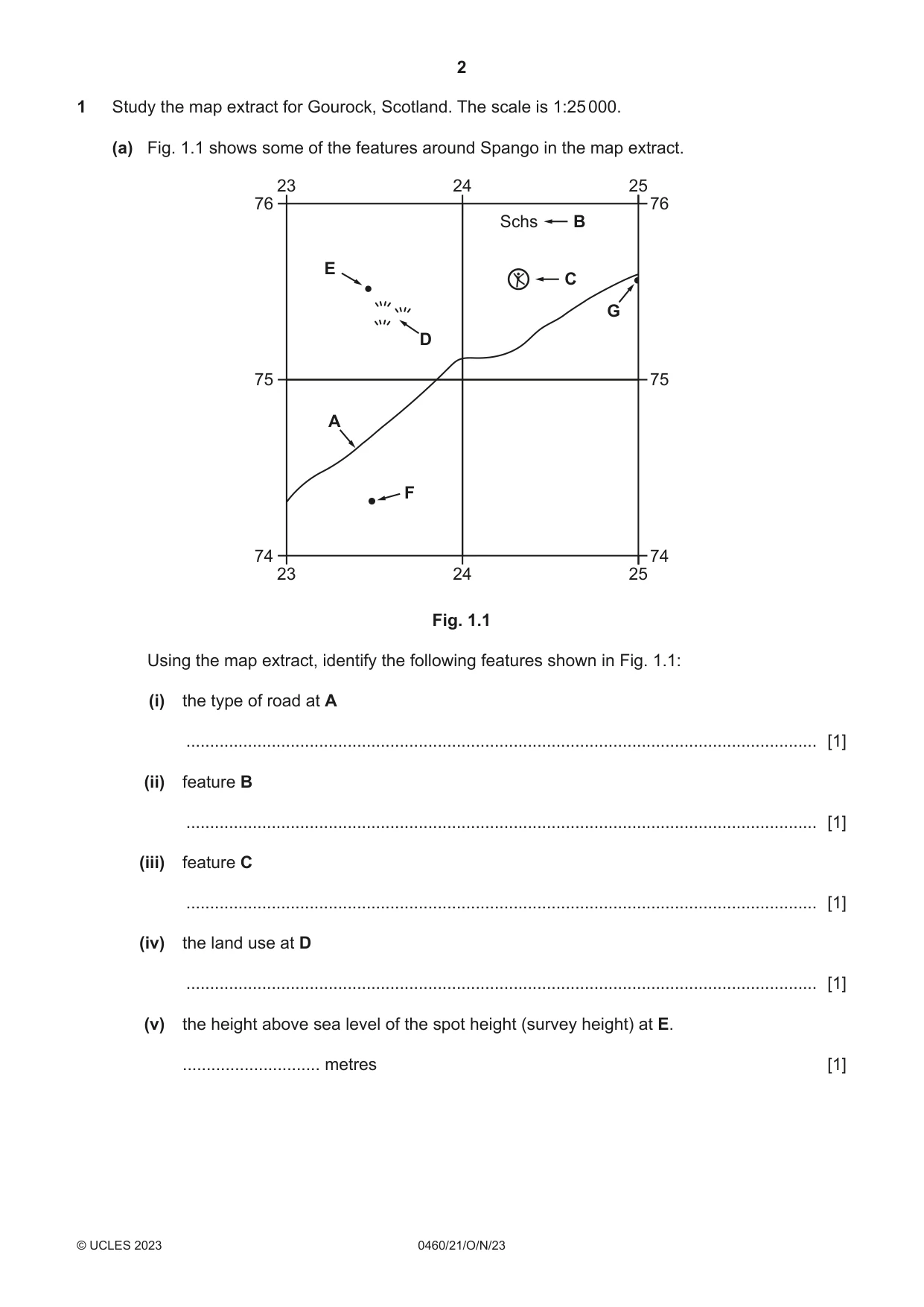
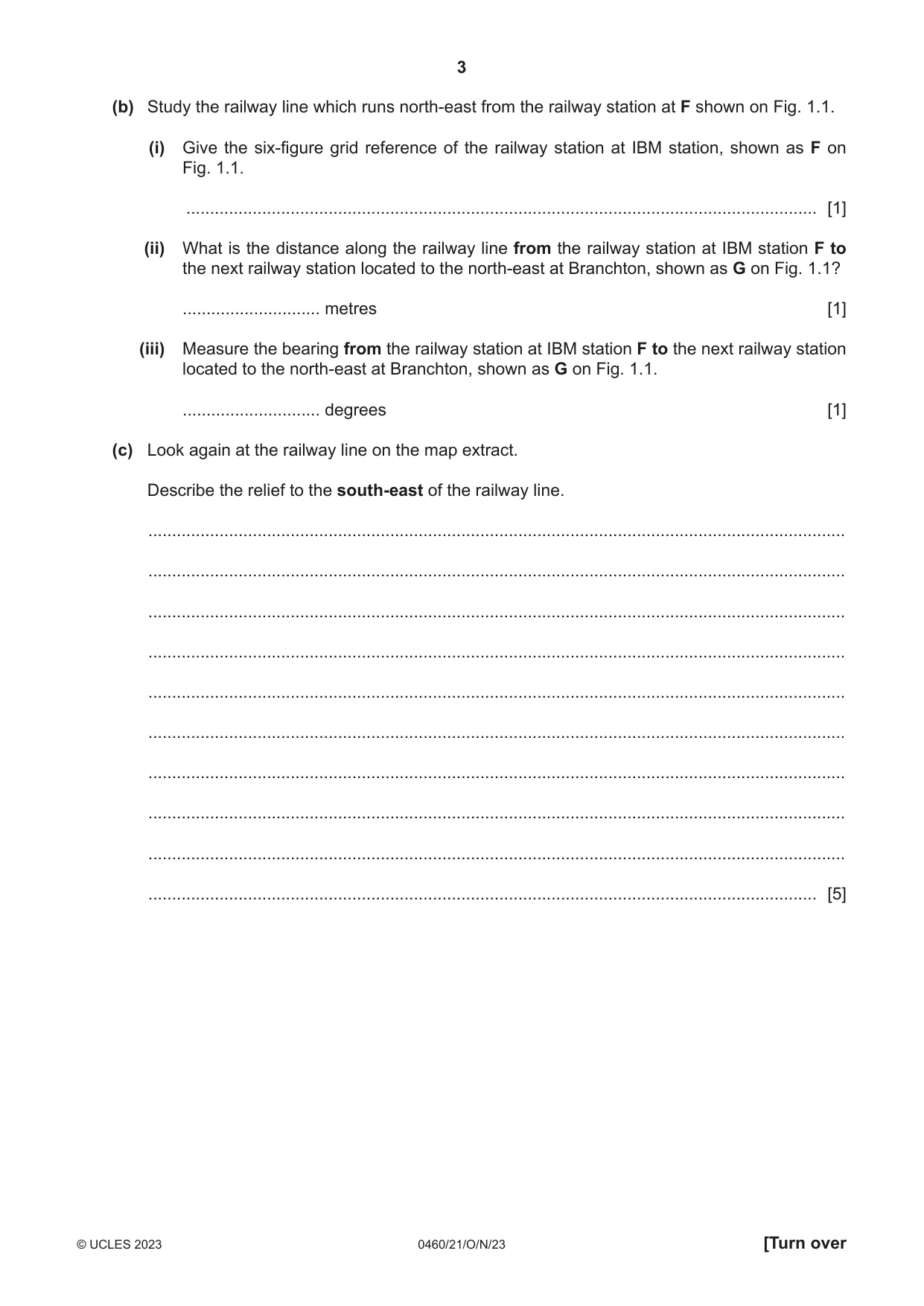
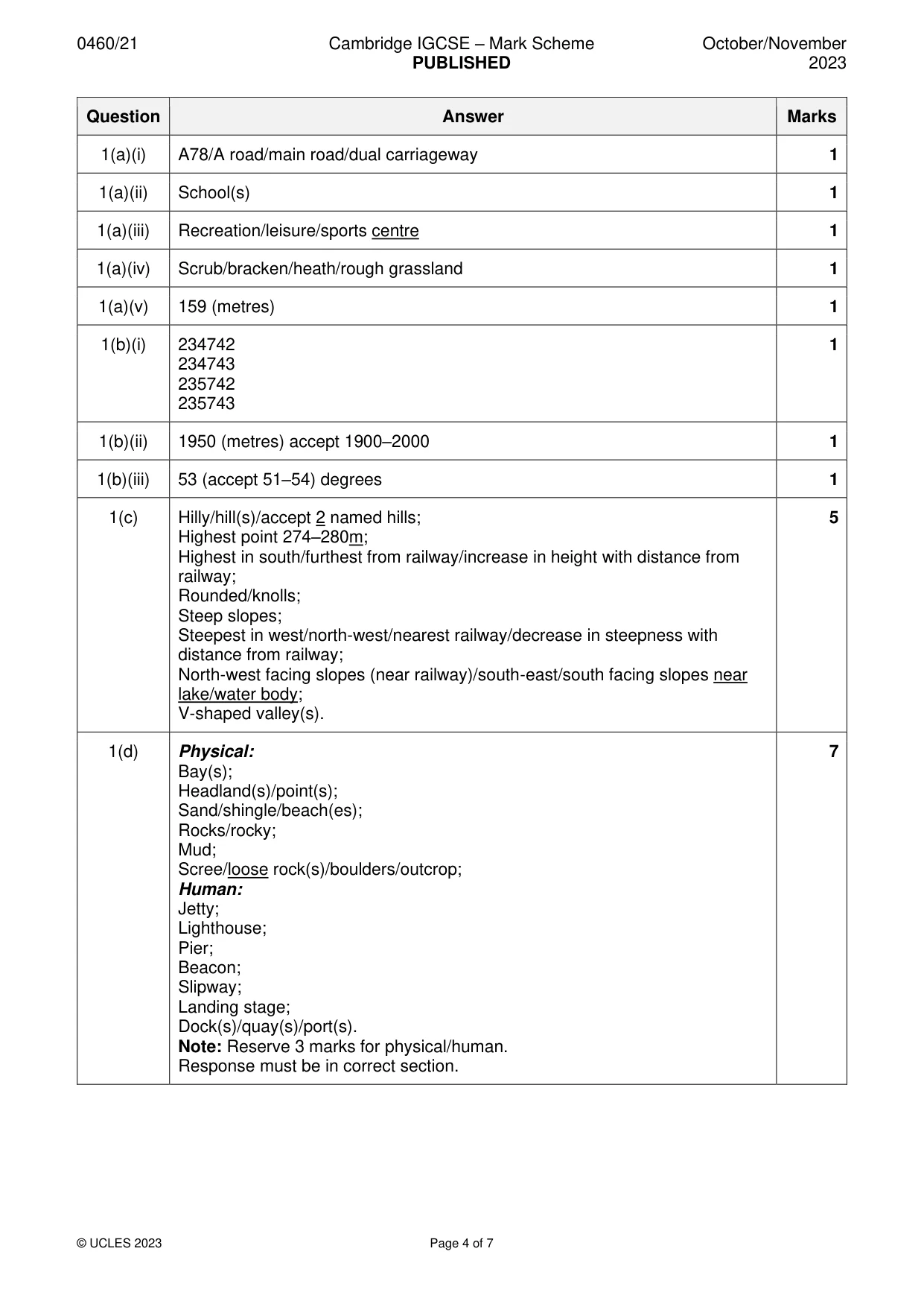
1 Study the map extract for Gourock, Scotland. The scale is 1:25 000. (a) Fig. 1.1 shows some of the features around Spango in the map extract. 23 24 25 76 76 Schs B E C G D 75 75 A F 74 74 23 24 25 Fig. 1.1 Using the map extract, identify the following features shown in Fig. 1.1: (i) the type of road at A ..................................................................................................................................... [1] (ii) feature B ..................................................................................................................................... [1] (iii) feature C ..................................................................................................................................... [1] (iv) the land use at D ..................................................................................................................................... [1] (v) the height above sea level of the spot height (survey height) at E. ............................. metres [1] (b) Study the railway line which runs north-east from the railway station at F shown on Fig. 1.1. (i) Give the six-figure grid reference of the railway station at IBM station, shown as F on Fig. 1.1. ..................................................................................................................................... [1] (ii) What is the distance along the railway line from the railway station at IBM station F to the next railway station located to the north-east at Branchton, shown as G on Fig. 1.1? ............................. metres [1] (iii) Measure the bearing from the railway station at IBM station F to the next railway station located to the north-east at Branchton, shown as G on Fig. 1.1. ............................. degrees [1] (c) Look again at the railway line on the map extract. Describe the relief to the south-east of the railway line. ................................................................................................................................................... ................................................................................................................................................... ................................................................................................................................................... ................................................................................................................................................... ................................................................................................................................................... ................................................................................................................................................... ................................................................................................................................................... ................................................................................................................................................... ................................................................................................................................................... ............................................................................................................................................. [5] (d) Describe the physical (natural) and human features of the coastline shown on the map extract. physical features ....................................................................................................................... ................................................................................................................................................... ................................................................................................................................................... ................................................................................................................................................... ................................................................................................................................................... ................................................................................................................................................... ................................................................................................................................................... human features ......................................................................................................................... ................................................................................................................................................... ................................................................................................................................................... ................................................................................................................................................... ................................................................................................................................................... ................................................................................................................................................... ............................................................................................................................................. [7] [Total: 20]
Mark scheme: Question Answer Marks 1(a)(i) A78/A road/main road/dual carriageway 1 1(a)(ii) School(s) 1 1(a)(iii) Recreation/leisure/sports centre 1 1(a)(iv) Scrub/bracken/heath/rough grassland 1 1(a)(v) 159 (metres) 1 1(b)(i) 234742 1 234743 235742 235743 1(b)(ii) 1950 (metres) accept 1900–2000 1 1(b)(iii) 53 (accept 51–54) degrees 1 1(c) Hilly/hill(s)/accept 2 named hills; 5 Highest point 274–280m; Highest in south/furthest from railway/increase in height with distance from railway; Rounded/knolls; Steep slopes; Steepest in west/north-west/nearest railway/decrease in steepness with distance from railway; North-west facing slopes (near railway)/south-east/south facing slopes near lake/water body; V-shaped valley(s). 1(d) Physical: 7 Bay(s); Headland(s)/point(s); Sand/shingle/beach(es); Rocks/rocky; Mud; Scree/loose rock(s)/boulders/outcrop; Human: Jetty; Lighthouse; Pier; Beacon; Slipway; Landing stage; Dock(s)/quay(s)/port(s). Note: Reserve 3 marks for physical/human. Response must be in correct section.
More questions on Settlements (rural and urban) and service provision
Q2 · The annual population growth rate of Burundi, Africa, between 1961 and 2019
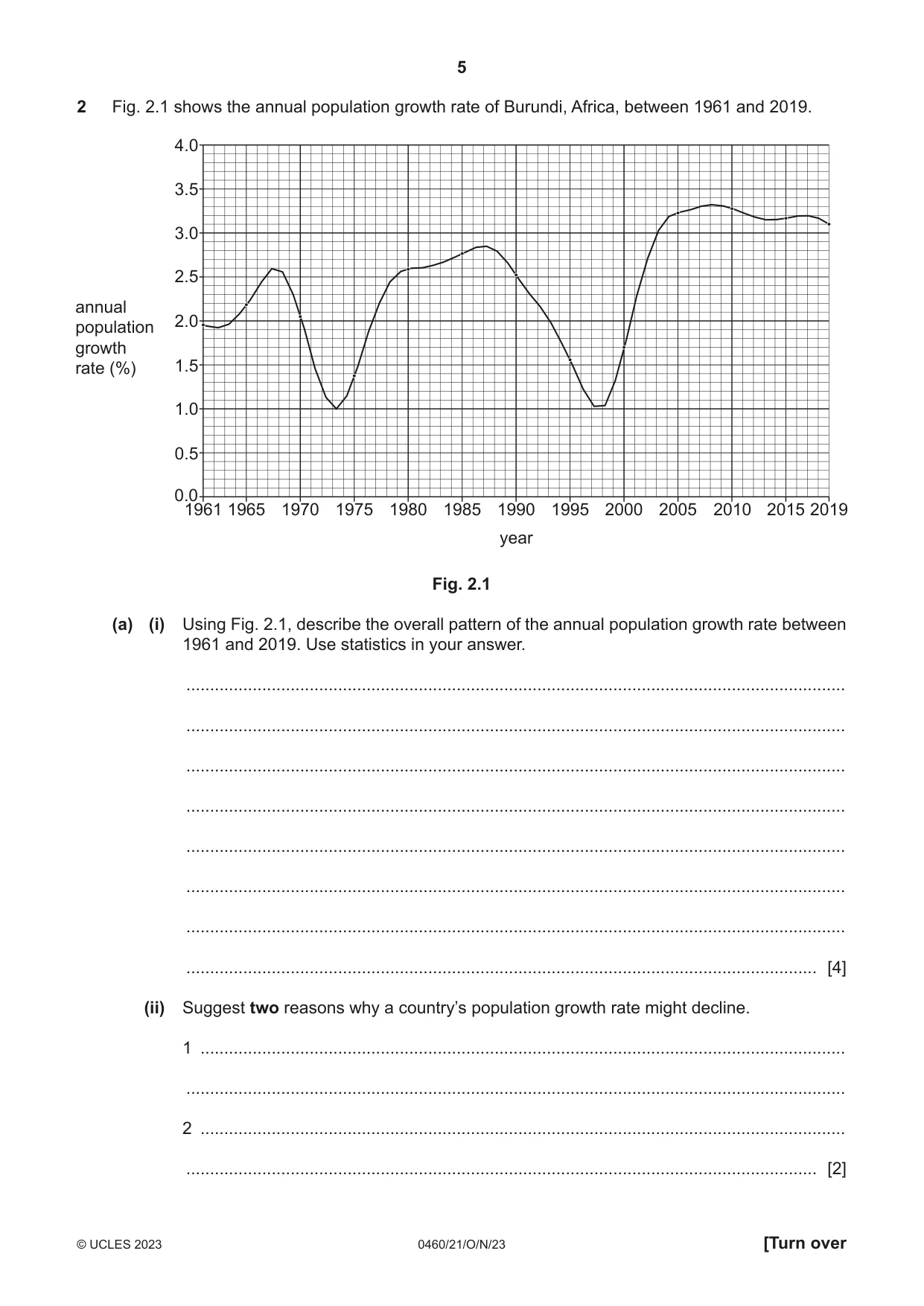
2 Fig. 2.1 shows the annual population growth rate of Burundi, Africa, between 1961 and 2019. 4.0 3.5 3.0 2.5 annual 2.0population growth rate (%) 1.5 1.0 0.5 0.0 1961 1965 1970 1975 1980 1985 1990 1995 2000 2005 2010 2015 2019 year Fig. 2.1 (a) (i) Using Fig. 2.1, describe the overall pattern of the annual population growth rate between 1961 and 2019. Use statistics in your answer. ........................................................................................................................................... ........................................................................................................................................... ........................................................................................................................................... ........................................................................................................................................... ........................................................................................................................................... ........................................................................................................................................... ........................................................................................................................................... ..................................................................................................................................... [4] (ii) Suggest two reasons why a country’s population growth rate might decline. 1 ........................................................................................................................................ ........................................................................................................................................... 2 ........................................................................................................................................ ..................................................................................................................................... [2] (b) Suggest two problems that could be caused by a high population growth rate. 1 ................................................................................................................................................ ................................................................................................................................................... 2 ................................................................................................................................................ ............................................................................................................................................. [2] [Total: 8]
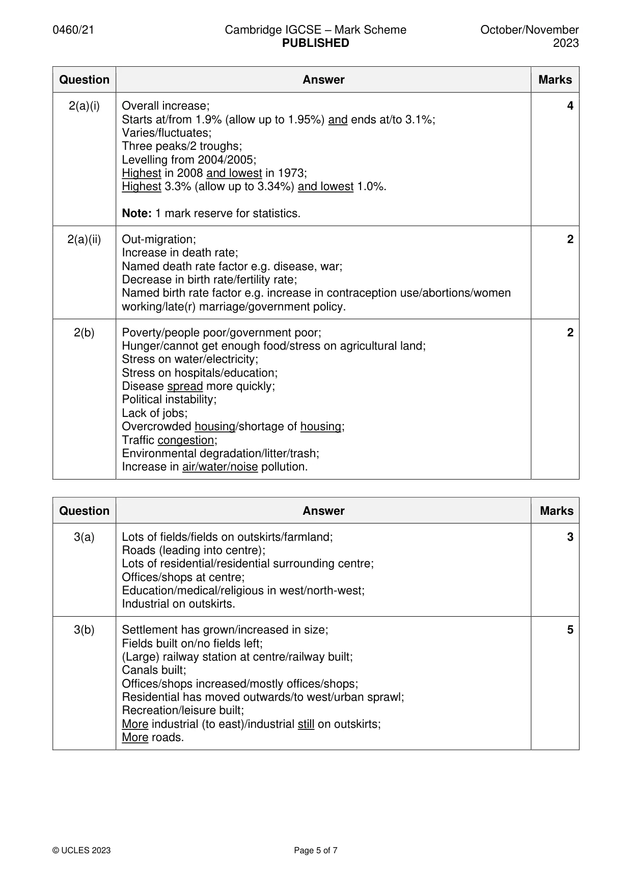
Mark scheme: 2(a)(i) Overall increase; 4 Starts at/from 1.9% (allow up to 1.95%) and ends at/to 3.1%; Varies/fluctuates; Three peaks/2 troughs; Levelling from 2004/2005; Highest in 2008 and lowest in 1973; Highest 3.3% (allow up to 3.34%) and lowest 1.0%. Note: 1 mark reserve for statistics. 2(a)(ii) Out-migration; 2 Increase in death rate; Named death rate factor e.g. disease, war; Decrease in birth rate/fertility rate; Named birth rate factor e.g. increase in contraception use/abortions/women working/late(r) marriage/government policy. 2(b) Poverty/people poor/government poor; 2 Hunger/cannot get enough food/stress on agricultural land; Stress on water/electricity; Stress on hospitals/education; Disease spread more quickly; Political instability; Lack of jobs; Overcrowded housing/shortage of housing; Traffic congestion; Environmental degradation/litter/trash; Increase in air/water/noise pollution.
Question 3
3 Figs. 3.1 and 3.2 (Insert) show the land use in and around the settlement of Birmingham, a city in the UK, in 1700 and 2014. (a) Using Fig. 3.1, describe the settlement of Birmingham in 1700. ................................................................................................................................................... ................................................................................................................................................... ................................................................................................................................................... ................................................................................................................................................... ................................................................................................................................................... ............................................................................................................................................. [3] (b) Using Figs. 3.1 and 3.2, describe how the land use has changed between 1700 and 2014. ................................................................................................................................................... ................................................................................................................................................... ................................................................................................................................................... ................................................................................................................................................... ................................................................................................................................................... ................................................................................................................................................... ................................................................................................................................................... ................................................................................................................................................... ................................................................................................................................................... ............................................................................................................................................. [5] [Total: 8]
Mark scheme: 3(a) Lots of fields/fields on outskirts/farmland; 3 Roads (leading into centre); Lots of residential/residential surrounding centre; Offices/shops at centre; Education/medical/religious in west/north-west; Industrial on outskirts. 3(b) Settlement has grown/increased in size; 5 Fields built on/no fields left; (Large) railway station at centre/railway built; Canals built; Offices/shops increased/mostly offices/shops; Residential has moved outwards/to west/urban sprawl; Recreation/leisure built; More industrial (to east)/industrial still on outskirts; More roads.
Question 4
4 Fig. 4.1 (Insert) shows pollution in Accra, the capital city of Ghana, a country in Africa. (a) Using Fig. 4.1, describe four types of pollution shown. 1 ................................................................................................................................................ ................................................................................................................................................... 2 ................................................................................................................................................ ................................................................................................................................................... 3 ................................................................................................................................................ ................................................................................................................................................... 4 ................................................................................................................................................ ............................................................................................................................................. [4] (b) Suggest four reasons why it may be difficult to reduce pollution in a city such as Accra. 1 ................................................................................................................................................ ................................................................................................................................................... 2 ................................................................................................................................................ ................................................................................................................................................... 3 ................................................................................................................................................ ................................................................................................................................................... 4 ................................................................................................................................................ ............................................................................................................................................. [4] [Total: 8]
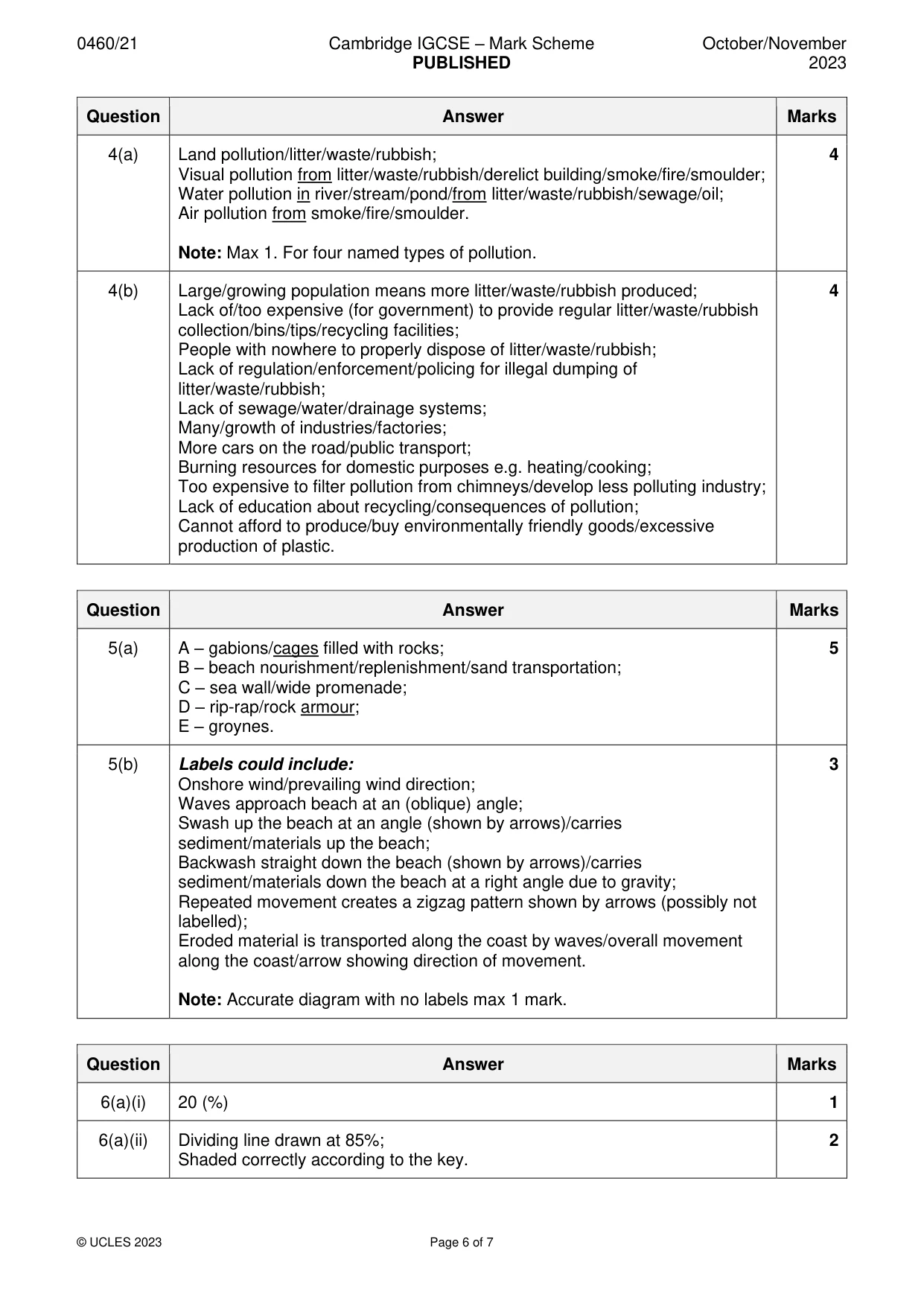
Mark scheme: 4(a) Land pollution/litter/waste/rubbish; 4 Visual pollution from litter/waste/rubbish/derelict building/smoke/fire/smoulder; Water pollution in river/stream/pond/from litter/waste/rubbish/sewage/oil; Air pollution from smoke/fire/smoulder. Note: Max 1. For four named types of pollution. 4(b) Large/growing population means more litter/waste/rubbish produced; 4 Lack of/too expensive (for government) to provide regular litter/waste/rubbish collection/bins/tips/recycling facilities; People with nowhere to properly dispose of litter/waste/rubbish; Lack of regulation/enforcement/policing for illegal dumping of litter/waste/rubbish; Lack of sewage/water/drainage systems; Many/growth of industries/factories; More cars on the road/public transport; Burning resources for domestic purposes e.g. heating/cooking; Too expensive to filter pollution from chimneys/develop less polluting industry; Lack of education about recycling/consequences of pollution; Cannot afford to produce/buy environmentally friendly goods/excessive production of plastic.
More questions on Environmental risks of economic development
Question 5
5 Fig. 5.1 (Insert) shows management techniques used to protect the coastline from erosion. (a) Using Fig. 5.1, name the coastal management techniques shown. A ............................................................................................................ B ............................................................................................................ C ............................................................................................................ D ............................................................................................................ E ............................................................................................................. [5] (b) Longshore drift can occur along coastal areas. Draw a labelled diagram to explain how longshore drift occurs. [3] [Total: 8]
Mark scheme: 5(a) A – gabions/cages filled with rocks; 5 B – beach nourishment/replenishment/sand transportation; C – sea wall/wide promenade; D – rip-rap/rock armour; E – groynes. 5(b) Labels could include: 3 Onshore wind/prevailing wind direction; Waves approach beach at an (oblique) angle; Swash up the beach at an angle (shown by arrows)/carries sediment/materials up the beach; Backwash straight down the beach (shown by arrows)/carries sediment/materials down the beach at a right angle due to gravity; Repeated movement creates a zigzag pattern shown by arrows (possibly not labelled); Eroded material is transported along the coast by waves/overall movement along the coast/arrow showing direction of movement. Note: Accurate diagram with no labels max 1 mark.
Q6 · Levels of children’s learning in three regions of the world
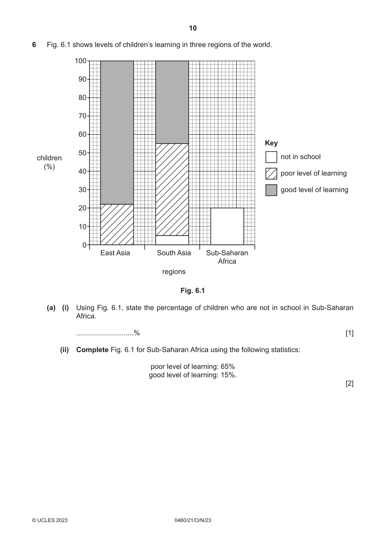
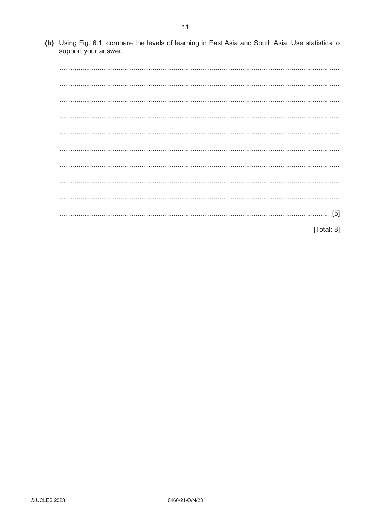
6 Fig. 6.1 shows levels of children’s learning in three regions of the world. 100 90 80 70 60 Key 50 children not in school (%) 40 poor level of learning 30 good level of learning 20 10 0 East Asia South Asia Sub-Saharan Africa regions Fig. 6.1 (a) (i) Using Fig. 6.1, state the percentage of children who are not in school in Sub-Saharan Africa. .............................% [1] (ii) Complete Fig. 6.1 for Sub-Saharan Africa using the following statistics: poor level of learning: 65% good level of learning: 15%. [2] (b) Using Fig. 6.1, compare the levels of learning in East Asia and South Asia. Use statistics to support your answer. ................................................................................................................................................... ................................................................................................................................................... ................................................................................................................................................... ................................................................................................................................................... ................................................................................................................................................... ................................................................................................................................................... ................................................................................................................................................... ................................................................................................................................................... ................................................................................................................................................... ............................................................................................................................................. [5] [Total: 8] Additional pages If you use the following pages to complete the answer to any question, the question number must be clearly shown. .................................................................................................................................................................. .................................................................................................................................................................. .................................................................................................................................................................. .................................................................................................................................................................. .................................................................................................................................................................. .................................................................................................................................................................. .................................................................................................................................................................. .................................................................................................................................................................. .................................................................................................................................................................. .................................................................................................................................................................. .................................................................................................................................................................. .................................................................................................................................................................. .................................................................................................................................................................. .................................................................................................................................................................. .................................................................................................................................................................. .................................................................................................................................................................. .................................................................................................................................................................. .................................................................................................................................................................. .................................................................................................................................................................. .................................................................................................................................................................. .................................................................................................................................................................. .................................................................................................................................................................. .................................................................................................................................................................. .................................................................................................................................................................. ..................................................................................................................................................................
Mark scheme: 6(a)(i) 20 (%) 1 6(a)(ii) Dividing line drawn at 85%; 2 Shaded correctly according to the key. 6(b) Level of learning better in East Asia/worse in South Asia; 5 More poor learning in South Asia; 50% compared to 22% in East Asia; More good learning in East Asia; 78% compared to 45% in South Asia; More out of school in South Asia; 5% out of school in South Asia/0% out of school in East Asia.
What was in this paper
The subtopics covered by these 6 questions, and how many questions each got. Open one in a new tab to see every Cambridge question on it.
What you needed in this session
Cambridge’s own grade thresholds for 2023 Oct/Nov, Paper 2 · Variant 1. A higher threshold means an easier paper — the bar moves with how the cohort did.