Cambridge IGCSE Geography 0460 — 2023 May/June Paper 2 · Variant 1
0460/21/M/J/23 · 6 questions · 60 marks · ≈68 min
The question paper and its mark scheme, free to read here and free to download. This is Cambridge’s own paper, exactly as it was sat.
Question paper20 pages




Mark scheme6 pages
Answers below. Sit the paper first if you are practising.



Questions as text
Q1 · Study the map extract for Kilmarnock, Scotland
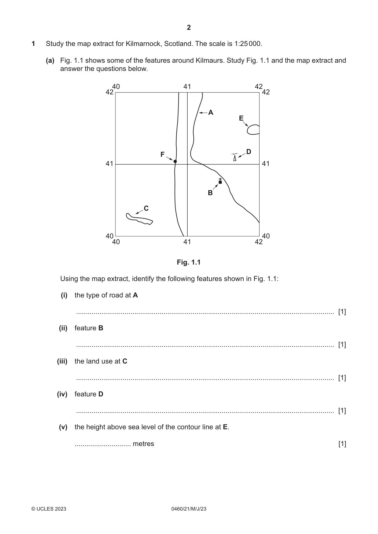
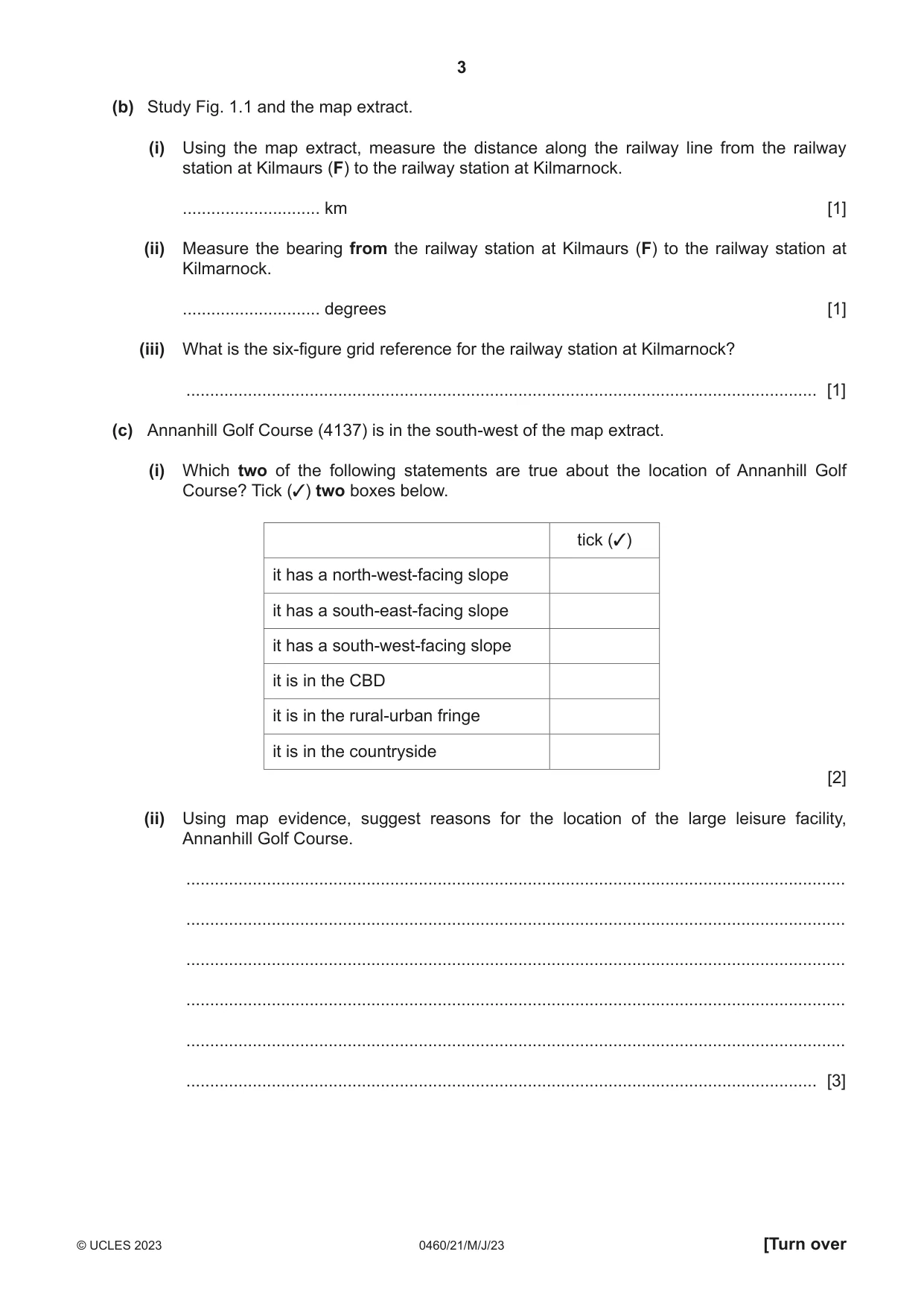
1 Study the map extract for Kilmarnock, Scotland. The scale is 1:25 000. (a) Fig. 1.1 shows some of the features around Kilmaurs. Study Fig. 1.1 and the map extract and answer the questions below. 40 41 42 42 42 A E D F 41 41 B C 40 40 40 41 42 Fig. 1.1 Using the map extract, identify the following features shown in Fig. 1.1: (i) the type of road at A ..................................................................................................................................... [1] (ii) feature B ..................................................................................................................................... [1] (iii) the land use at C ..................................................................................................................................... [1] (iv) feature D ..................................................................................................................................... [1] (v) the height above sea level of the contour line at E. ............................. metres [1] (b) Study Fig. 1.1 and the map extract. (i) Using the map extract, measure the distance along the railway line from the railway station at Kilmaurs (F) to the railway station at Kilmarnock. ............................. km [1] (ii) Measure the bearing from the railway station at Kilmaurs (F) to the railway station at Kilmarnock. ............................. degrees [1] (iii) What is the six-figure grid reference for the railway station at Kilmarnock? ..................................................................................................................................... [1] (c) Annanhill Golf Course (4137) is in the south-west of the map extract. (i) Which two of the following statements are true about the location of Annanhill Golf Course? Tick (3) two boxes below. tick (3) it has a north-west-facing slope it has a south-east-facing slope it has a south-west-facing slope it is in the CBD it is in the rural-urban fringe it is in the countryside [2] (ii) Using map evidence, suggest reasons for the location of the large leisure facility, Annanhill Golf Course. ........................................................................................................................................... ........................................................................................................................................... ........................................................................................................................................... ........................................................................................................................................... ........................................................................................................................................... ..................................................................................................................................... [3] (d) Describe the human and physical (natural) features of the River Irvine, which flows in the south of the map extract. Human features ................................................................................................................................................... ................................................................................................................................................... ................................................................................................................................................... ................................................................................................................................................... ................................................................................................................................................... ................................................................................................................................................... ................................................................................................................................................... ................................................................................................................................................... ................................................................................................................................................... ................................................................................................................................................... Physical features ................................................................................................................................................... ................................................................................................................................................... ................................................................................................................................................... ................................................................................................................................................... ................................................................................................................................................... ................................................................................................................................................... ................................................................................................................................................... ................................................................................................................................................... ................................................................................................................................................... ............................................................................................................................................. [7] [Total: 20]
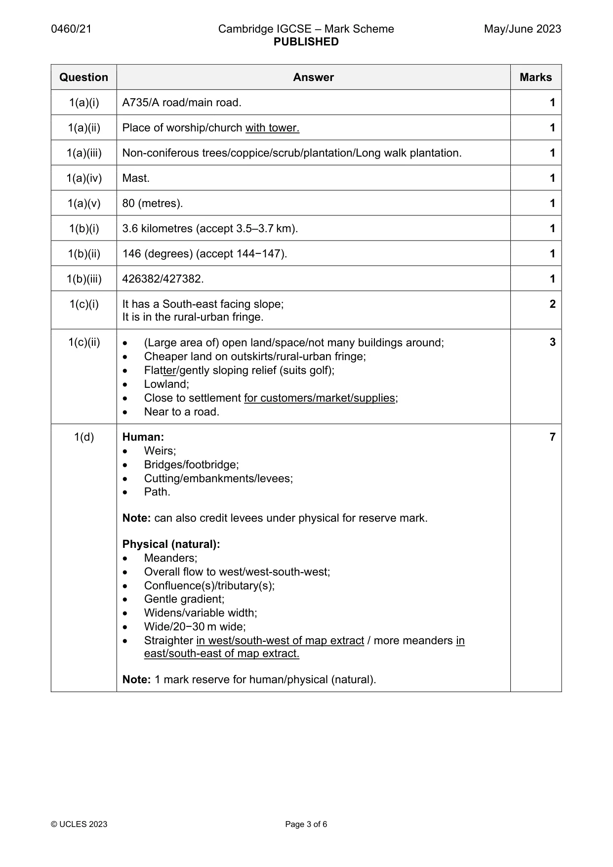
Mark scheme: Question Answer Marks 1(a)(i) A735/A road/main road. 1 1(a)(ii) Place of worship/church with tower. 1 1(a)(iii) Non-coniferous trees/coppice/scrub/plantation/Long walk plantation. 1 1(a)(iv) Mast. 1 1(a)(v) 80 (metres). 1 1(b)(i) 3.6 kilometres (accept 3.5–3.7 km). 1 1(b)(ii) 146 (degrees) (accept 144−147). 1 1(b)(iii) 426382/427382. 1 1(c)(i) It has a South-east facing slope; 2 It is in the rural-urban fringe. 1(c)(ii) (Large area of) open land/space/not many buildings around; 3 Cheaper land on outskirts/rural-urban fringe; Flatter/gently sloping relief (suits golf); Lowland; Close to settlement for customers/market/supplies; Near to a road. 1(d) Human: 7 Weirs; Bridges/footbridge; Cutting/embankments/levees; Path. Note: can also credit levees under physical for reserve mark. Physical (natural): Meanders; Overall flow to west/west-south-west; Confluence(s)/tributary(s); Gentle gradient; Widens/variable width; Wide/20−30 m wide; Straighter in west/south-west of map extract / more meanders in east/south-east of map extract. Note: 1 mark reserve for human/physical (natural).
More questions on Settlements (rural and urban) and service provision
Question 2
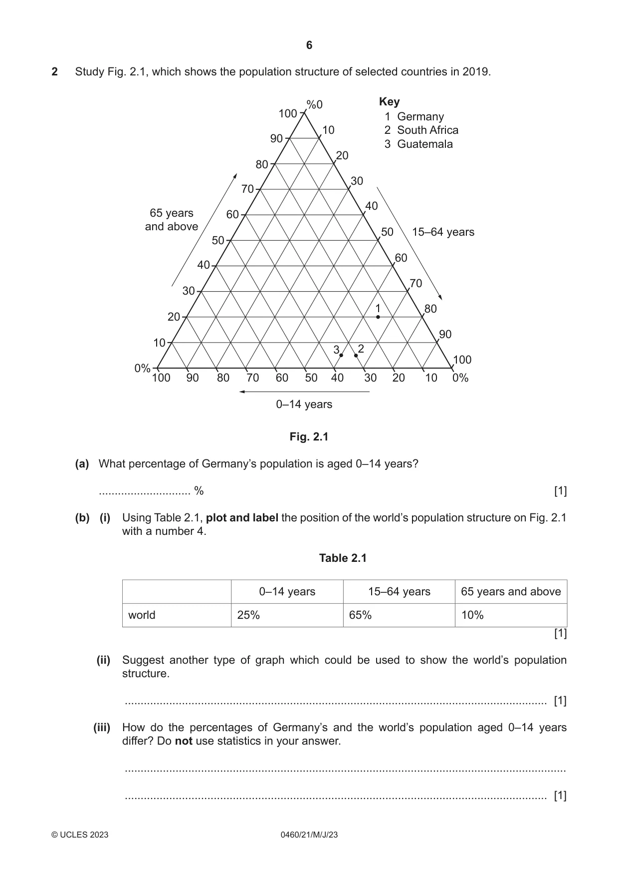
2 Study Fig. 2.1, which shows the population structure of selected countries in 2019. %0 Key 100 1 Germany 10 2 South Africa 90 3 Guatemala 20 80 30 70 40 65 years 60 and above 50 15–64 years 50 60 40 70 30 1 80 20 90 10 3 2 100 0% 100 90 80 70 60 50 40 30 20 10 0% 0–14 years Fig. 2.1 (a) What percentage of Germany’s population is aged 0–14 years? ............................. % [1] (b) (i) Using Table 2.1, plot and label the position of the world’s population structure on Fig. 2.1 with a number 4. Table 2.1 0–14 years 15–64 years 65 years and above world 25% 65% 10% [1] (ii) Suggest another type of graph which could be used to show the world’s population structure. ..................................................................................................................................... [1] (iii) How do the percentages of Germany’s and the world’s population aged 0–14 years differ? Do not use statistics in your answer. ........................................................................................................................................... ..................................................................................................................................... [1] (c) Suggest four problems caused by an ageing population. 1 ................................................................................................................................................ ................................................................................................................................................... 2 ................................................................................................................................................ ................................................................................................................................................... 3 ................................................................................................................................................ ................................................................................................................................................... 4 ................................................................................................................................................ ............................................................................................................................................. [4] [Total: 8]
Mark scheme: 2(a) 15 (%). 1 2(b)(i) Correctly plotted and labelled. 1 2(b)(ii) Population pyramid/(divided/compound) bar graph/pie graph/pie chart/donut 1 graph. 2(b)(iii) Germany is lower/the world is higher. 1 2(c) Need more care/nursing homes; 4 Pressure/strain/higher spending on health services; More money needed for pensions; Less economically active/smaller workforce; Less tax payers/workforce need to pay higher taxes; Increased proportion not contributing to economy; Less money for other services e.g., education; More difficult to defend country/recruit to forces; Immigration to fill jobs; Lower birth rate.
Question 3
3 Study Figs. 3.1, 3.2 and 3.3 (Insert), which show different areas of the city of Kuala Lumpur, Malaysia, an LEDC. (a) (i) Identify each land-use zone. Choose your answers from the following: industrial residential CBD rural-urban fringe transportation Fig. 3.1 ............................................................................................................................... Fig. 3.2 ............................................................................................................................... Fig. 3.3 ............................................................................................................................... [3] (ii) Suggest one reason why each area shown in Figs. 3.1, 3.2 and 3.3 has high-rise buildings. ........................................................................................................................................... ..................................................................................................................................... [1] (b) Figs. 3.4 and 3.5 (Insert) show models of urban land use in an MEDC and an LEDC. Compare the urban land-use models shown in Figs. 3.4 and 3.5. ................................................................................................................................................... ................................................................................................................................................... ................................................................................................................................................... ................................................................................................................................................... ................................................................................................................................................... ................................................................................................................................................... ................................................................................................................................................... ............................................................................................................................................. [4] [Total: 8]
Mark scheme: 3(a)(i) CBD; 3 Rural-urban fringe; Residential. 3(a)(ii) High cost of land/cheaper to build upwards; 1 Shortage of land/saves space; Need/demand for housing/offices; Large population can be accommodated. 3(b) CBD in centre in both; 4 Both have rings; MEDC has rings/LEDC has (rings and) wedges; Industry in centre in MEDC and in wedge/toward outskirts in LEDC; High class residential on outskirts in MEDC and in wedge/surrounding CBD in LEDC; No low class residential in LEDC; No medium class residential in LEDC; No informal housing in MEDC; Lower class toward centre in MEDC and toward outskirts in LEDC.
Q4 · The definitions of some terms used in the study of rivers and drainage basins
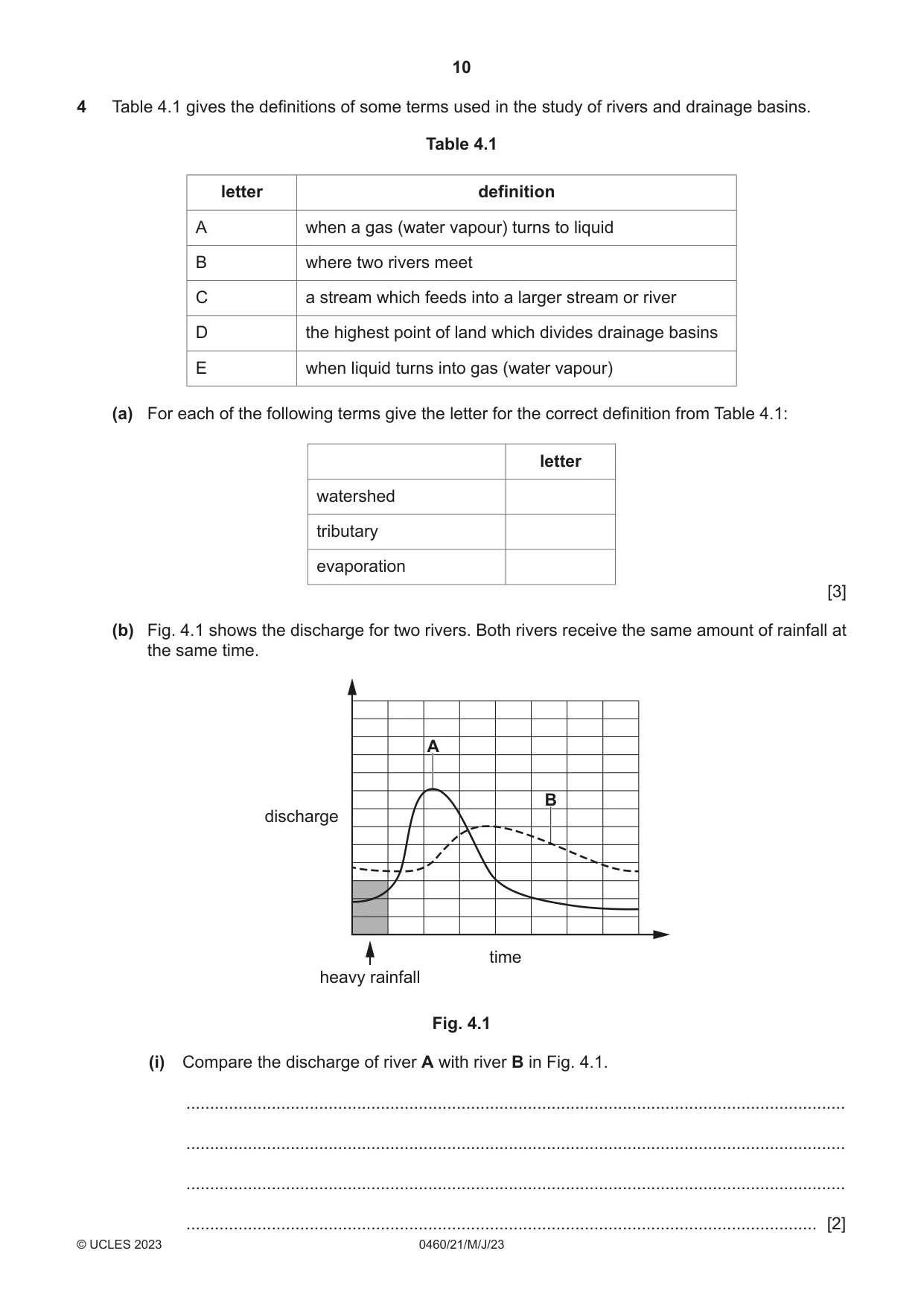
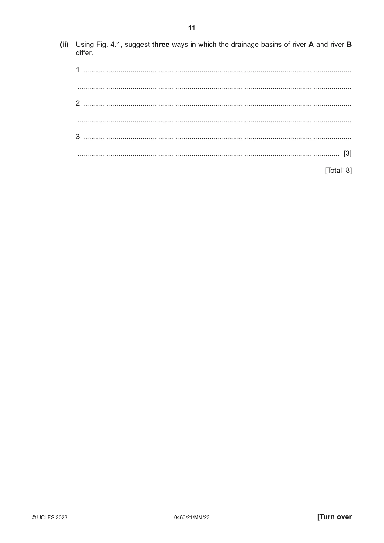
4 Table 4.1 gives the definitions of some terms used in the study of rivers and drainage basins. Table 4.1 letter definition A when a gas (water vapour) turns to liquid B where two rivers meet C a stream which feeds into a larger stream or river D the highest point of land which divides drainage basins E when liquid turns into gas (water vapour) (a) For each of the following terms give the letter for the correct definition from Table 4.1: letter watershed tributary evaporation [3] (b) Fig. 4.1 shows the discharge for two rivers. Both rivers receive the same amount of rainfall at the same time. A B discharge time heavy rainfall Fig. 4.1 (i) Compare the discharge of river A with river B in Fig. 4.1. ........................................................................................................................................... ........................................................................................................................................... ........................................................................................................................................... ..................................................................................................................................... [2] (ii) Using Fig. 4.1, suggest three ways in which the drainage basins of river A and river B differ. 1 ........................................................................................................................................ ........................................................................................................................................... 2 ........................................................................................................................................ ........................................................................................................................................... 3 ........................................................................................................................................ ..................................................................................................................................... [3] [Total: 8]
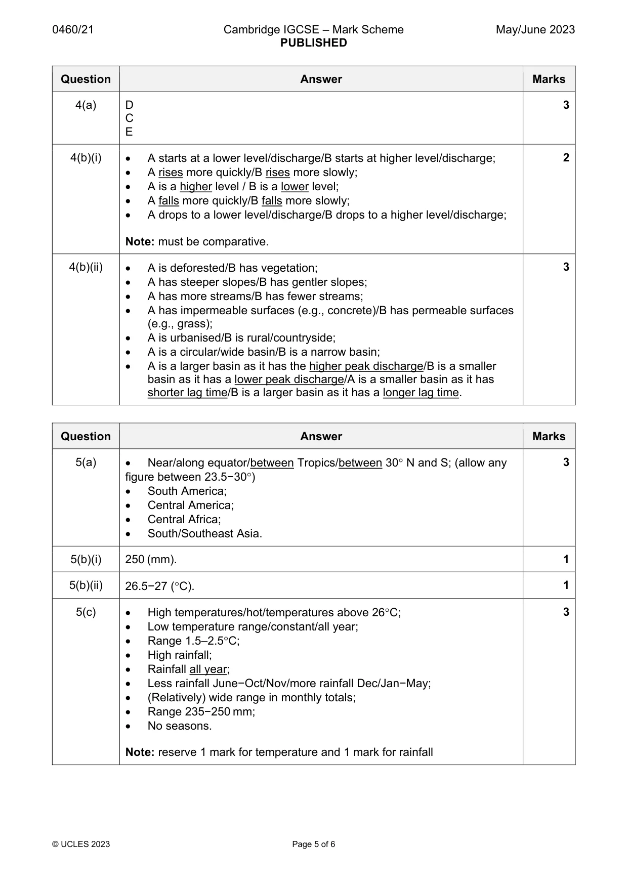
Mark scheme: 4(a) D 3 C E 4(b)(i) A starts at a lower level/discharge/B starts at higher level/discharge; 2 A rises more quickly/B rises more slowly; A is a higher level / B is a lower level; A falls more quickly/B falls more slowly; A drops to a lower level/discharge/B drops to a higher level/discharge; Note: must be comparative. 4(b)(ii) A is deforested/B has vegetation; 3 A has steeper slopes/B has gentler slopes; A has more streams/B has fewer streams; A has impermeable surfaces (e.g., concrete)/B has permeable surfaces (e.g., grass); A is urbanised/B is rural/countryside; A is a circular/wide basin/B is a narrow basin; A is a larger basin as it has the higher peak discharge/B is a smaller basin as it has a lower peak discharge/A is a smaller basin as it has shorter lag time/B is a larger basin as it has a longer lag time.
Q5 · The global distribution of tropical rainforests
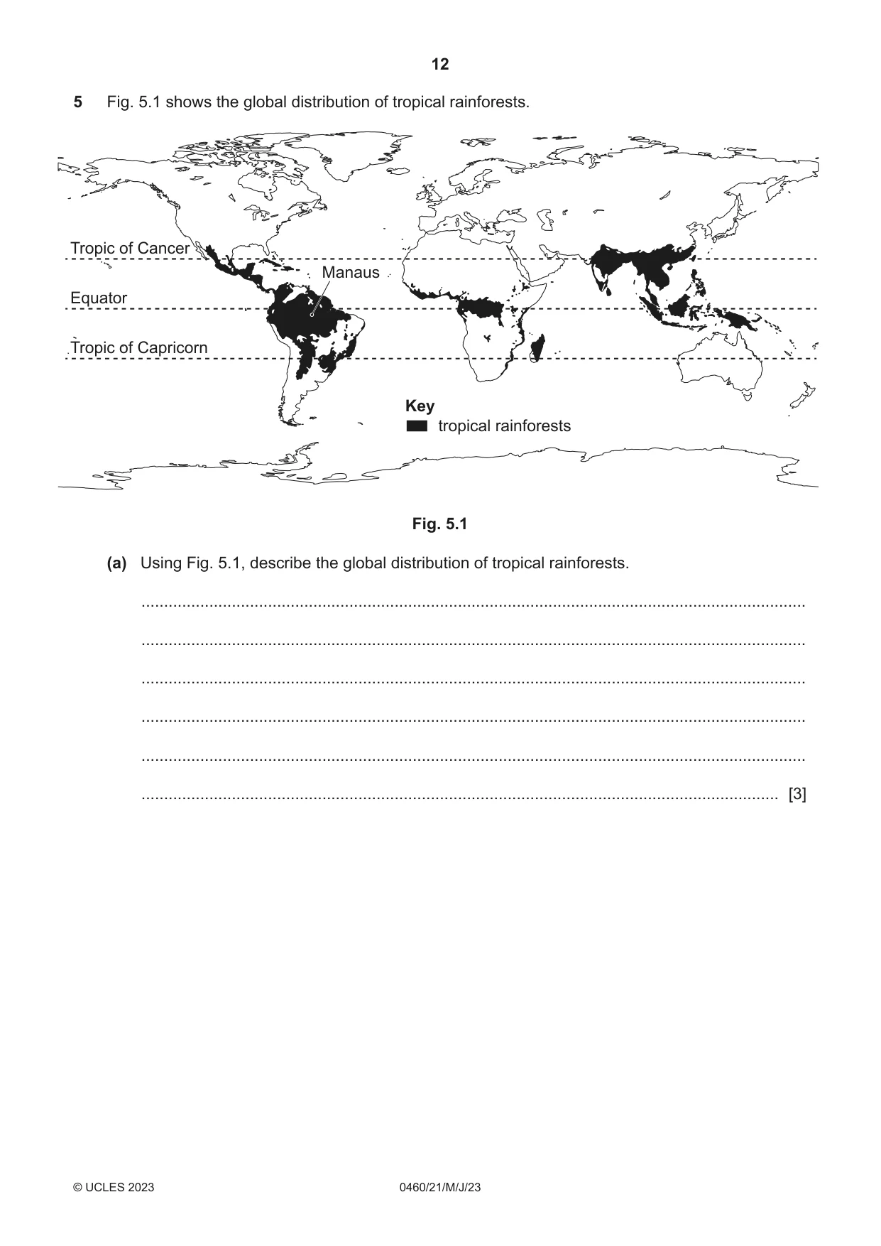
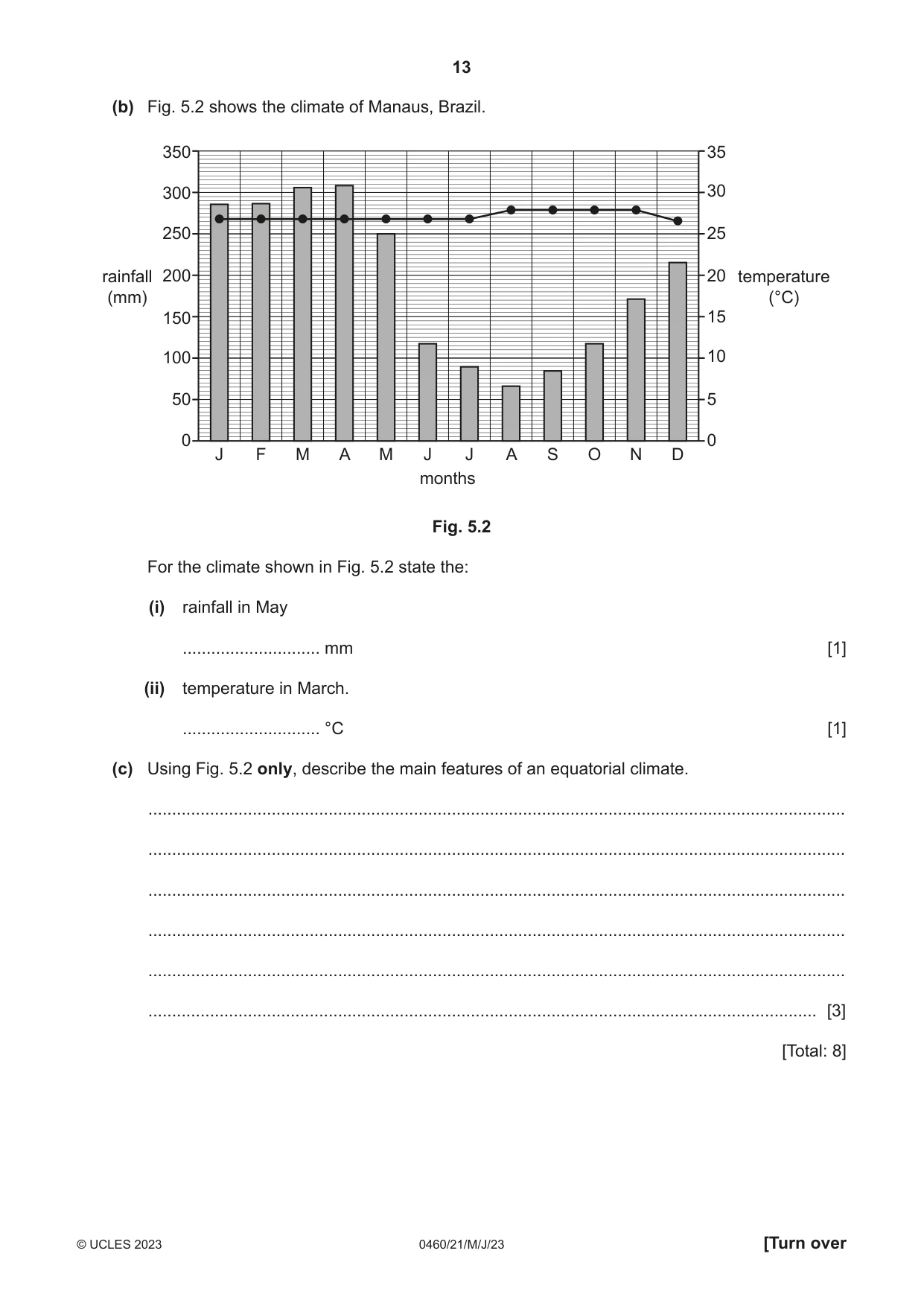
5 Fig. 5.1 shows the global distribution of tropical rainforests. Tropic of Cancer Manaus Equator Tropic of Capricorn Key tropical rainforests Fig. 5.1 (a) Using Fig. 5.1, describe the global distribution of tropical rainforests. ................................................................................................................................................... ................................................................................................................................................... ................................................................................................................................................... ................................................................................................................................................... ................................................................................................................................................... ............................................................................................................................................. [3] (b) Fig. 5.2 shows the climate of Manaus, Brazil. 350 35 300 30 250 25 rainfall 200 20 temperature (mm) (°C) 150 15 100 10 50 5 0 0 J F M A M J J A S O N D months Fig. 5.2 For the climate shown in Fig. 5.2 state the: (i) rainfall in May ............................. mm [1] (ii) temperature in March. ............................. °C [1] (c) Using Fig. 5.2 only, describe the main features of an equatorial climate. ................................................................................................................................................... ................................................................................................................................................... ................................................................................................................................................... ................................................................................................................................................... ................................................................................................................................................... ............................................................................................................................................. [3] [Total: 8]
Mark scheme: 5(a) Near/along equator/between Tropics/between 30 N and S; (allow any 3 figure between 23.5−30) South America; Central America; Central Africa; South/Southeast Asia. 5(b)(i) 250 (mm). 1 5(b)(ii) 26.5−27 (C). 1 5(c) High temperatures/hot/temperatures above 26C; 3 Low temperature range/constant/all year; Range 1.5–2.5C; High rainfall; Rainfall all year; Less rainfall June−Oct/Nov/more rainfall Dec/Jan−May; (Relatively) wide range in monthly totals; Range 235−250 mm; No seasons. Note: reserve 1 mark for temperature and 1 mark for rainfall
Question 6
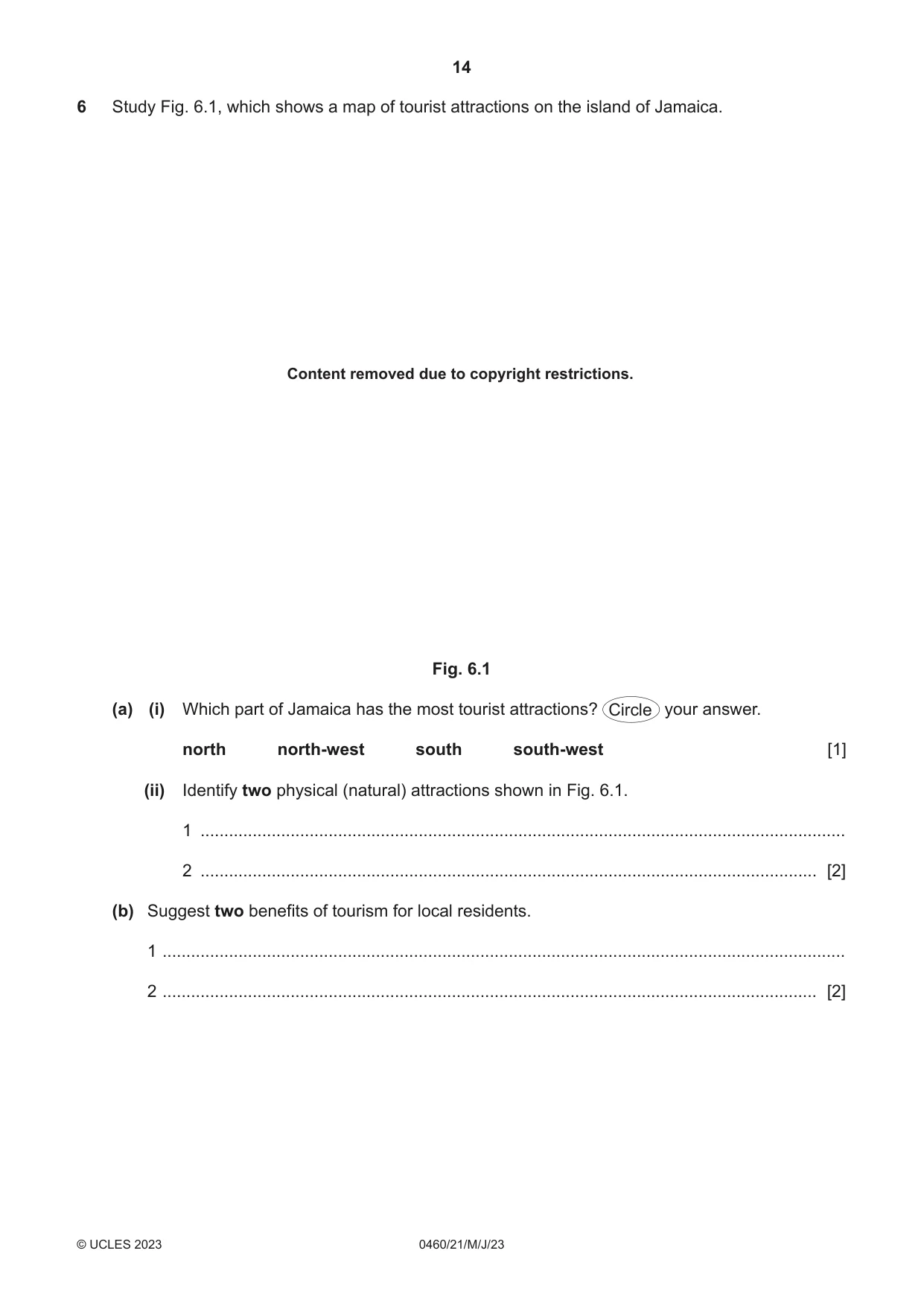
6 Study Fig. 6.1, which shows a map of tourist attractions on the island of Jamaica. Content removed due to copyright restrictions. Fig. 6.1 (a) (i) Which part of Jamaica has the most tourist attractions? Circle your answer. north north-west south south-west [1] (ii) Identify two physical (natural) attractions shown in Fig. 6.1. 1 ........................................................................................................................................ 2 .................................................................................................................................. [2] (b) Suggest two benefits of tourism for local residents. 1 ................................................................................................................................................ 2 .......................................................................................................................................... [2] (c) Suggest ways in which the Jamaican government can encourage sustainable development of tourism on the island. ................................................................................................................................................... ................................................................................................................................................... ................................................................................................................................................... ................................................................................................................................................... ................................................................................................................................................... ............................................................................................................................................. [3] [Total: 8] Additional pages If you use the following pages to complete the answer to any question, the question number must be clearly shown. .................................................................................................................................................................. .................................................................................................................................................................. .................................................................................................................................................................. .................................................................................................................................................................. .................................................................................................................................................................. .................................................................................................................................................................. .................................................................................................................................................................. .................................................................................................................................................................. .................................................................................................................................................................. .................................................................................................................................................................. .................................................................................................................................................................. .................................................................................................................................................................. .................................................................................................................................................................. .................................................................................................................................................................. .................................................................................................................................................................. .................................................................................................................................................................. .................................................................................................................................................................. .................................................................................................................................................................. .................................................................................................................................................................. .................................................................................................................................................................. .................................................................................................................................................................. .................................................................................................................................................................. .................................................................................................................................................................. .................................................................................................................................................................. ..................................................................................................................................................................
Mark scheme: 6(a)(i) North/north-west. 1 6(a)(ii) Hills/mountains; 2 Caving; Beaches/bays; Safaris. 6(b) Jobs/employment (or e.g., of tourist job); 2 Income/money/increase in the local economy/sales/profits/support for businesses; Cultural exchange/learn languages/promotes local culture/cultural understanding; Preserve traditions; Development of roads/water supply/electricity/railways/ airports/ sewerage/telecommunications; More facilities/services available for locals (or e.g., of tourist facility). 6(c) Limit tourist numbers/limit number of flights to the island; 3 Strict controls on tourist developments; Fines for littering/noise; Clean beaches/litter pick up exercises; Educating/advertising/campaigns for tourists e.g., not littering/not disturbing wildlife; Grants for eco-tourist developments; Promote cycling/more cycle paths/free public bikes; Electric vehicles/vehicles with reduced CO2 emissions; Develop public transport; Use of renewable energy in tourist accommodation/attractions; Nature reserves/conservation areas/national parks/marine parks; Employ locals as tour guides; Locals provide accommodation; Limit water use/example of limiting water use; Tourism tax.
What was in this paper
The subtopics covered by these 6 questions, and how many questions each got. Open one in a new tab to see every Cambridge question on it.
What you needed in this session
Cambridge’s own grade thresholds for 2023 May/June, Paper 2 · Variant 1. A higher threshold means an easier paper — the bar moves with how the cohort did.