Cambridge IGCSE Geography 0460 — 2016 May/June Paper 2 · Variant 3
0460/23/M/J/16 · 60 marks · ≈68 min
The question paper and its mark scheme, free to read here and free to download. This is Cambridge’s own paper, exactly as it was sat.
Question paper16 pages

Mark scheme5 pages
Answers below. Sit the paper first if you are practising.
Paper as text
Question paper, page 1
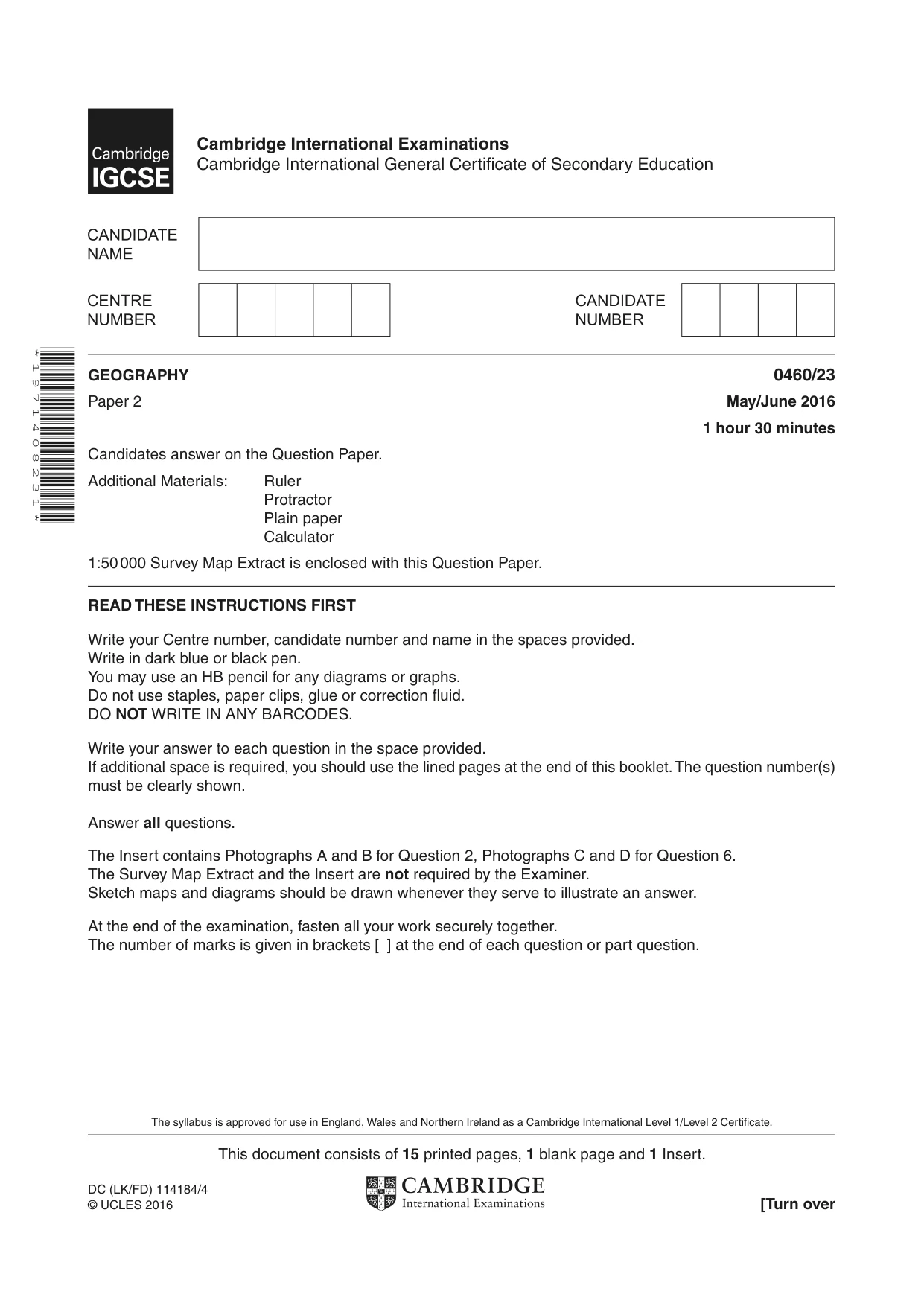
This document consists of 15 printed pages, 1 blank page and 1 Insert. DC (LK/FD) 114184/4 © UCLES 2016 [Turn over Cambridge International Examinations Cambridge International General Certificate of Secondary Education * 1 9 7 1 4 0 8 2 3 1 * GEOGRAPHY 0460/23 Paper 2 May/June 2016 1 hour 30 minutes Candidates answer on the Question Paper. Additional Materials: Ruler Protractor Plain paper Calculator 1:50 000 Survey Map Extract is enclosed with this Question Paper. READ THESE INSTRUCTIONS FIRST Write your Centre number, candidate number and name in the spaces provided. Write in dark blue or black pen. You may use an HB pencil for any diagrams or graphs. Do not use staples, paper clips, glue or correction fluid. DO NOT WRITE IN ANY BARCODES. Write your answer to each question in the space provided. If additional space is required, you should use the lined pages at the end of this booklet. The question number(s) must be clearly shown. Answer all questions. The Insert contains Photographs A and B for Question 2, Photographs C and D for Question 6. The Survey Map Extract and the Insert are not required by the Examiner. Sketch maps and diagrams should be drawn whenever they serve to illustrate an answer. At the end of the examination, fasten all your work securely together. The number of marks is given in brackets [ ] at the end of each question or part question. The syllabus is approved for use in England, Wales and Northern Ireland as a Cambridge International Level 1/Level 2 Certificate.
Question paper, page 2
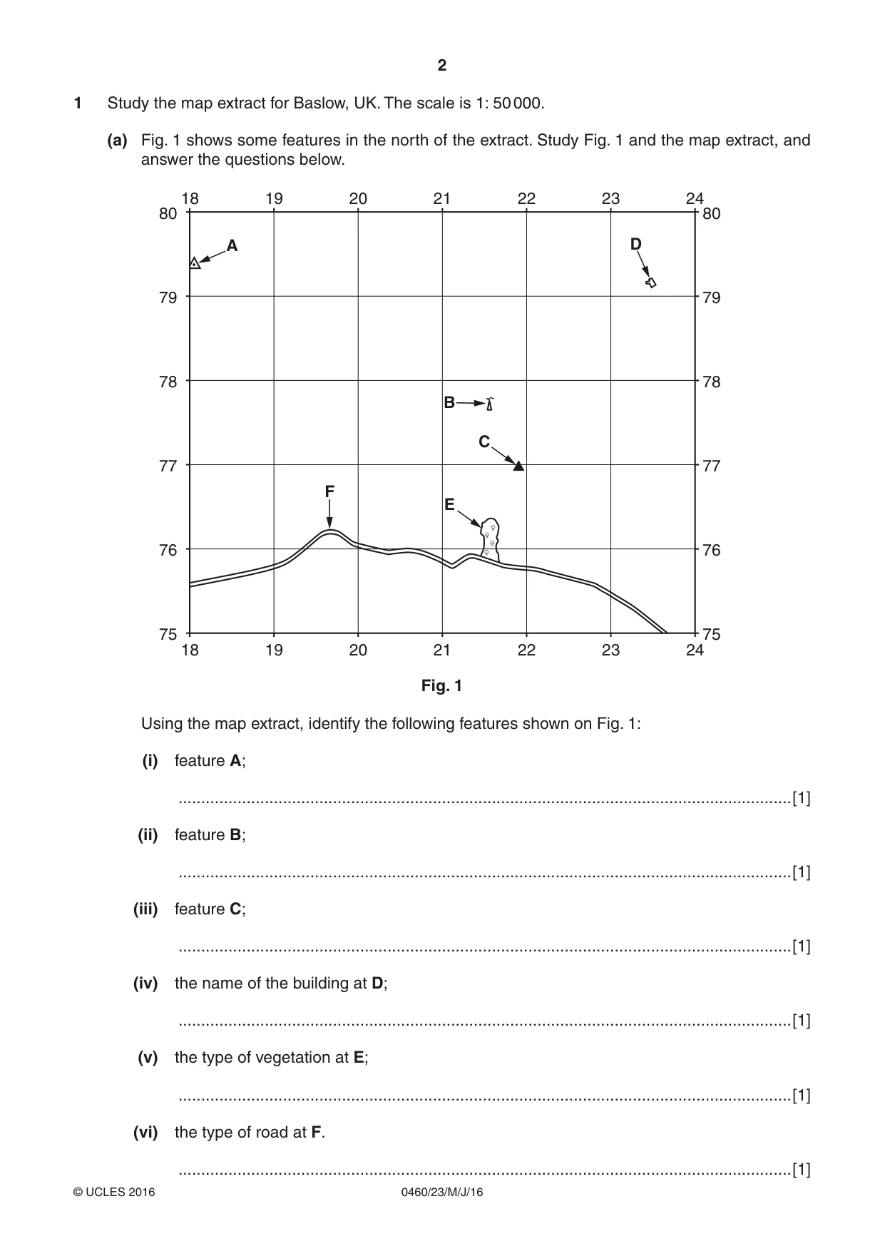
2 0460/23/M/J/16 © UCLES 2016 1 Study the map extract for Baslow, UK. The scale is 1: 50 000. (a) Fig. 1 shows some features in the north of the extract. Study Fig. 1 and the map extract, and answer the questions below. 80 79 78 77 76 75 80 79 78 77 76 75 24 23 22 21 20 19 18 24 23 22 21 20 19 18 D A B E F C Fig. 1 Using the map extract, identify the following features shown on Fig. 1: (i) feature A; …[1] (ii) feature B; …[1] (iii) feature C; …[1] (iv) the name of the building at D; …[1] (v) the type of vegetation at E; …[1] (vi) the type of road at F. …[1]
Question paper, page 3
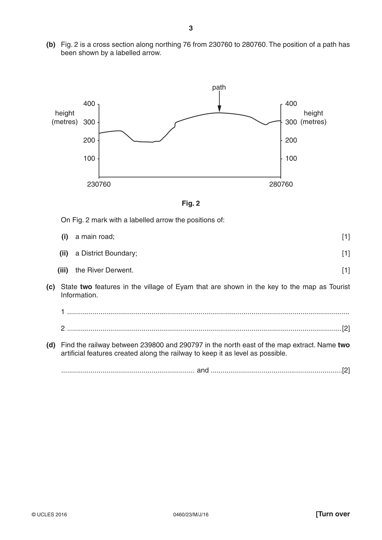
3 0460/23/M/J/16 © UCLES 2016 [Turn over (b) Fig. 2 is a cross section along northing 76 from 230760 to 280760. The position of a path has been shown by a labelled arrow. 400 height (metres) height (metres) path 300 200 100 230760 280760 400 300 200 100 Fig. 2 On Fig. 2 mark with a labelled arrow the positions of: (i) a main road; [1] (ii) a District Boundary; [1] (iii) the River Derwent. [1] (c) State two features in the village of Eyam that are shown in the key to the map as Tourist Information. 1 … 2 …[2] (d) Find the railway between 239800 and 290797 in the north east of the map extract. Name two artificial features created along the railway to keep it as level as possible. … and …[2]
Question paper, page 4
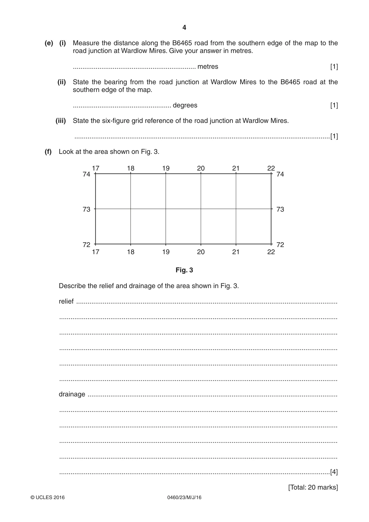
4 0460/23/M/J/16 © UCLES 2016 (e) (i) Measure the distance along the B6465 road from the southern edge of the map to the road junction at Wardlow Mires. Give your answer in metres. … metres [1] (ii) State the bearing from the road junction at Wardlow Mires to the B6465 road at the southern edge of the map. … degrees [1] (iii) State the six-figure grid reference of the road junction at Wardlow Mires. …[1] (f) Look at the area shown on Fig. 3. 74 73 72 74 73 72 22 21 20 19 18 17 22 21 20 19 18 17 Fig. 3 Describe the relief and drainage of the area shown in Fig. 3. relief … … … … … … drainage … … … … … …[4] [Total: 20 marks]
Question paper, page 5
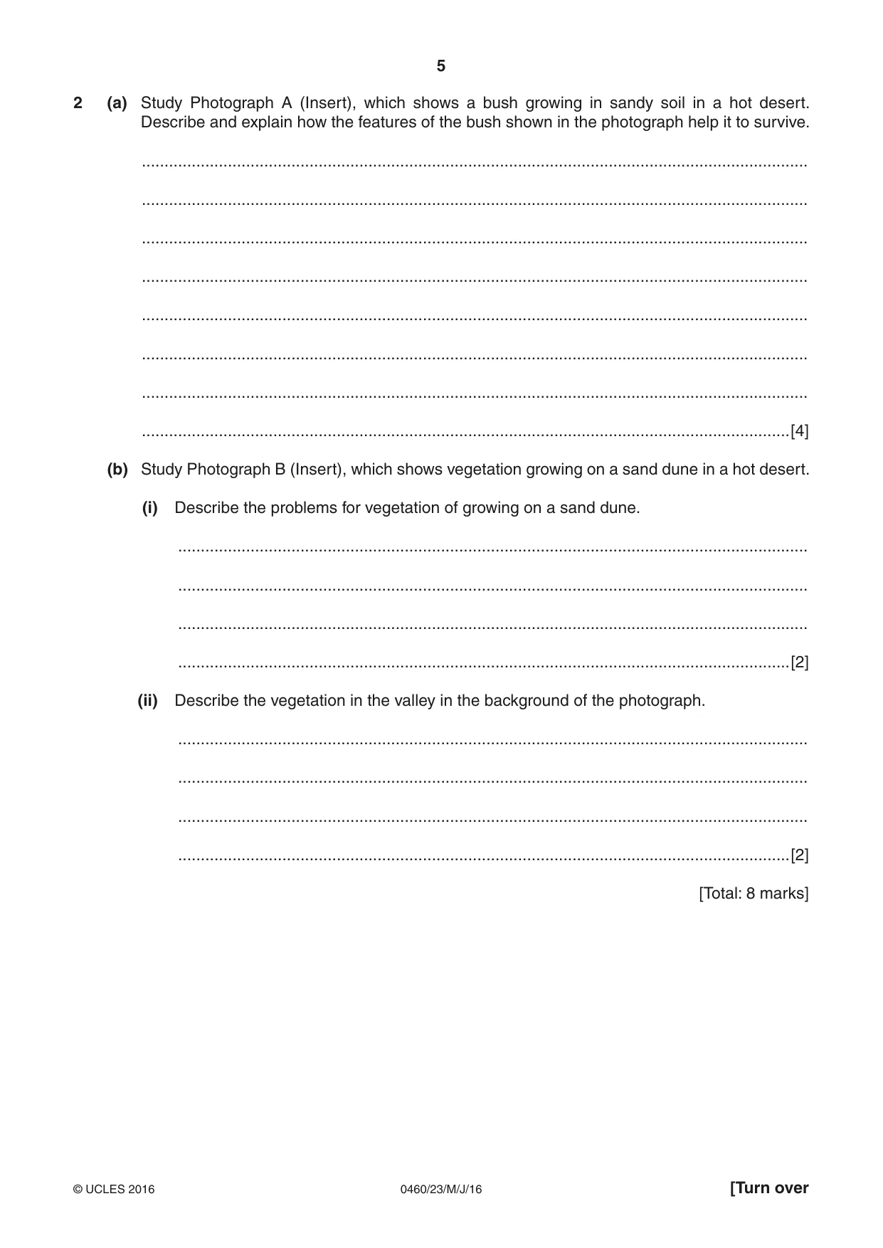
5 0460/23/M/J/16 © UCLES 2016 [Turn over 2 (a) Study Photograph A (Insert), which shows a bush growing in sandy soil in a hot desert. Describe and explain how the features of the bush shown in the photograph help it to survive. … … … … … … … …[4] (b) Study Photograph B (Insert), which shows vegetation growing on a sand dune in a hot desert. (i) Describe the problems for vegetation of growing on a sand dune. … … … …[2] (ii) Describe the vegetation in the valley in the background of the photograph. … … … …[2] [Total: 8 marks]
Question paper, page 6
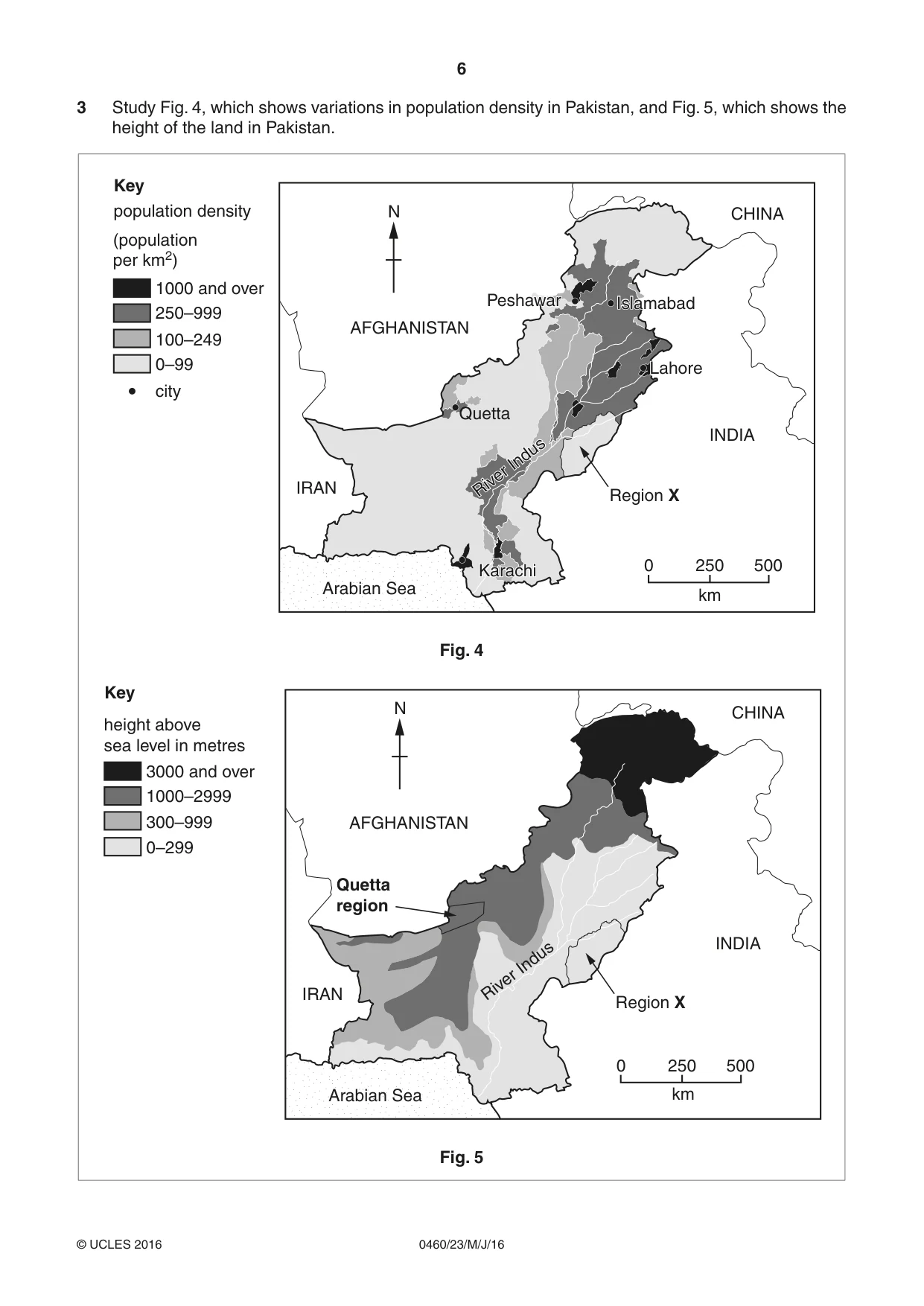
6 0460/23/M/J/16 © UCLES 2016 3 Study Fig. 4, which shows variations in population density in Pakistan, and Fig. 5, which shows the height of the land in Pakistan. River Indus River Indus 0 250 km 500 N Islamabad Islamabad Quetta Karachi Karachi Peshawar Peshawar Lahore Lahore IRAN Arabian Sea AFGHANISTAN 0–99 city population density (population per km2) Key 100–249 250–999 1000 and over INDIA Region X CHINA Fig. 4 0 250 500 N Quetta region IRAN Arabian Sea AFGHANISTAN INDIA River Indus Region X CHINA 0–299 height above sea level in metres Key 300–999 1000–2999 3000 and over km Fig. 5
Question paper, page 7
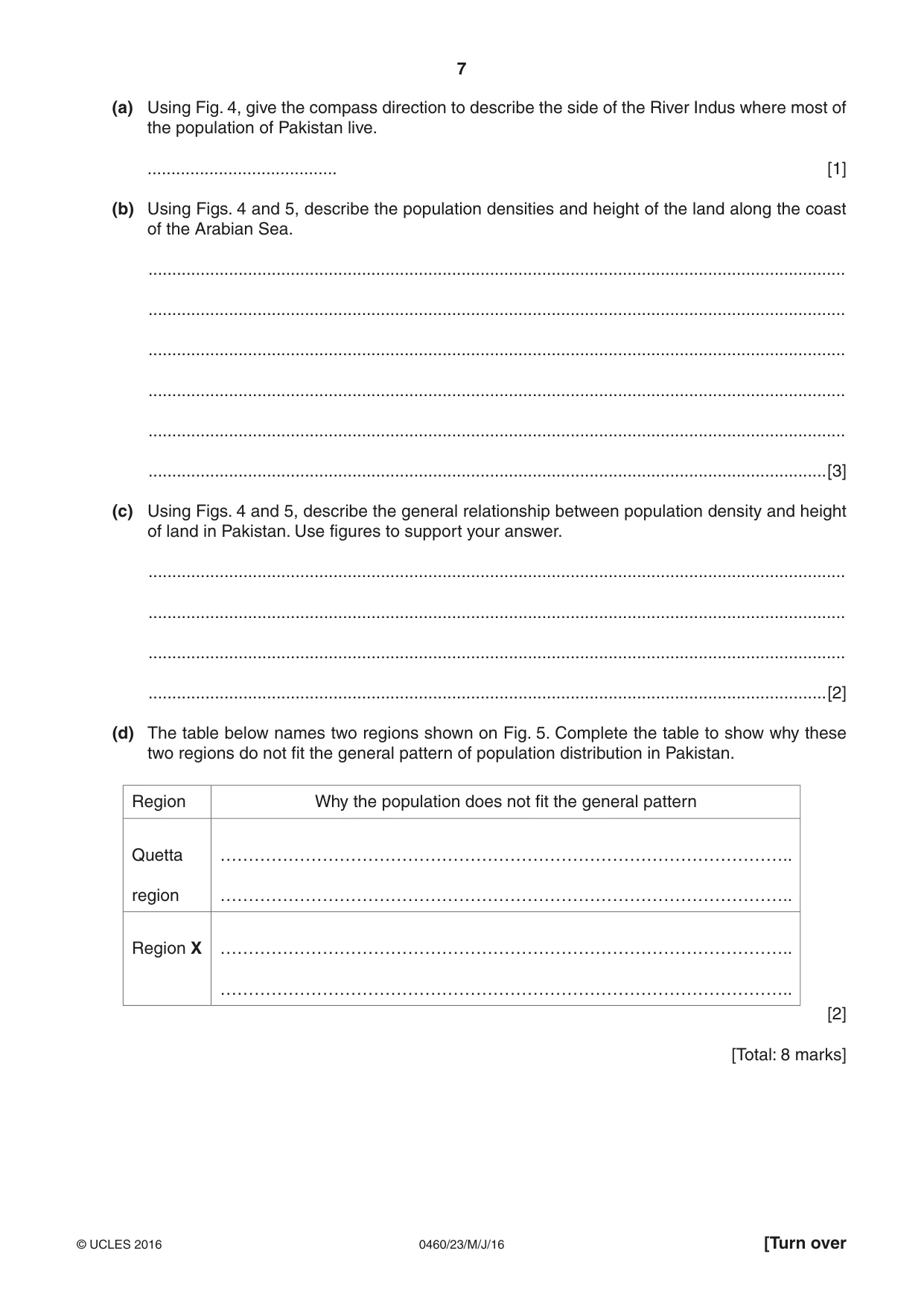
7 0460/23/M/J/16 © UCLES 2016 [Turn over (a) Using Fig. 4, give the compass direction to describe the side of the River Indus where most of the population of Pakistan live. … [1] (b) Using Figs. 4 and 5, describe the population densities and height of the land along the coast of the Arabian Sea. … … … … … …[3] (c) Using Figs. 4 and 5, describe the general relationship between population density and height of land in Pakistan. Use figures to support your answer. … … … …[2] (d) The table below names two regions shown on Fig. 5. Complete the table to show why these two regions do not fit the general pattern of population distribution in Pakistan. Region Why the population does not fit the general pattern Quetta region ……………………………………………………………………………………….. ……………………………………………………………………………………….. Region X ……………………………………………………………………………………….. ……………………………………………………………………………………….. [2] [Total: 8 marks]
Question paper, page 8
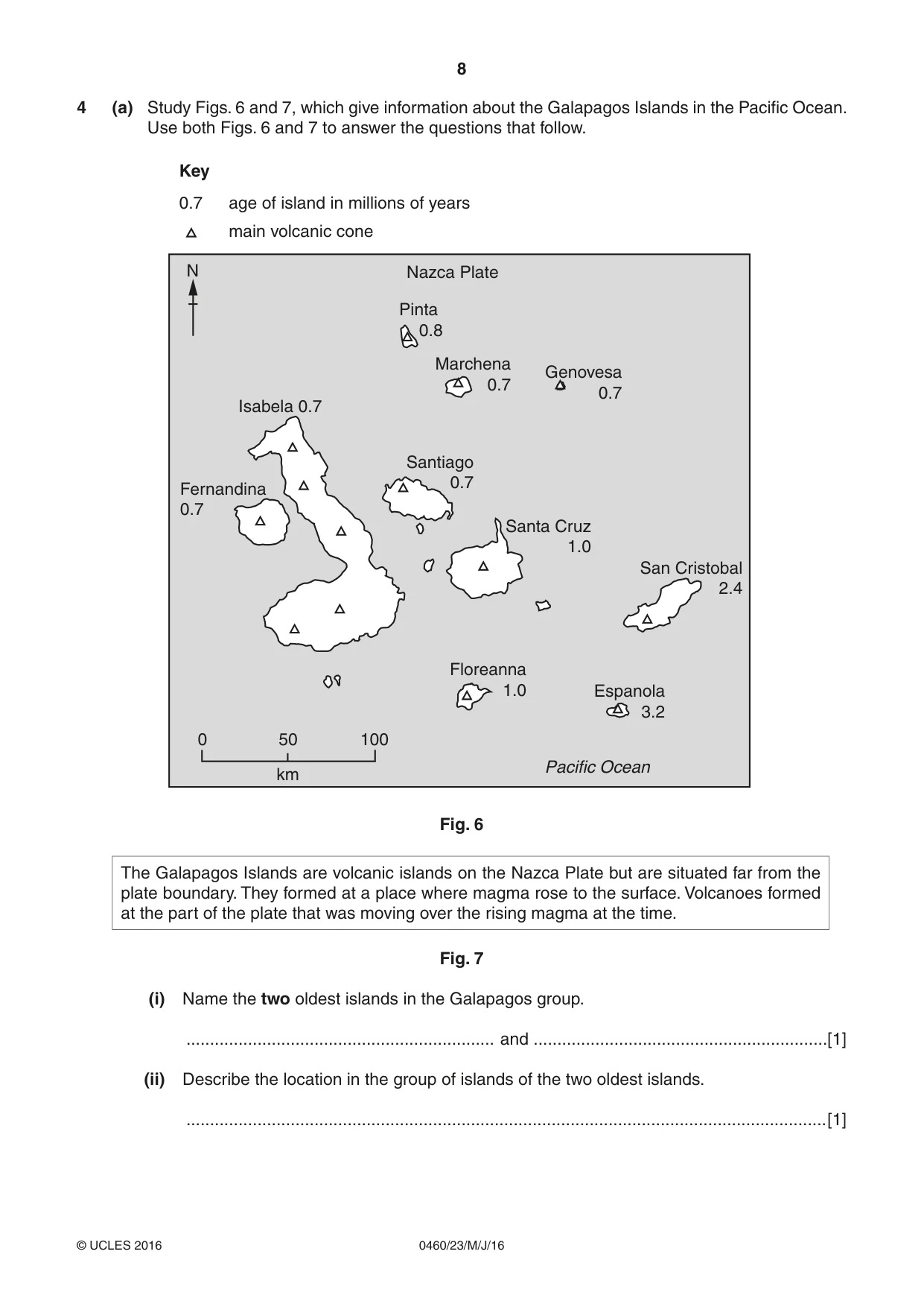
8 0460/23/M/J/16 © UCLES 2016 4 (a) Study Figs. 6 and 7, which give information about the Galapagos Islands in the Pacific Ocean. Use both Figs. 6 and 7 to answer the questions that follow. 0 50 100 Floreanna 1.0 Espanola 3.2 San Cristobal 2.4 Santa Cruz 1.0 Santiago 0.7 Fernandina 0.7 Isabela 0.7 Pinta 0.8 Nazca Plate age of island in millions of years main volcanic cone Key Marchena 0.7 0.7 Genovesa 0.7 km Pacific Ocean N Fig. 6 The Galapagos Islands are volcanic islands on the Nazca Plate but are situated far from the plate boundary. They formed at a place where magma rose to the surface. Volcanoes formed at the part of the plate that was moving over the rising magma at the time. Fig. 7 (i) Name the two oldest islands in the Galapagos group. … and …[1] (ii) Describe the location in the group of islands of the two oldest islands. …[1]
Question paper, page 9
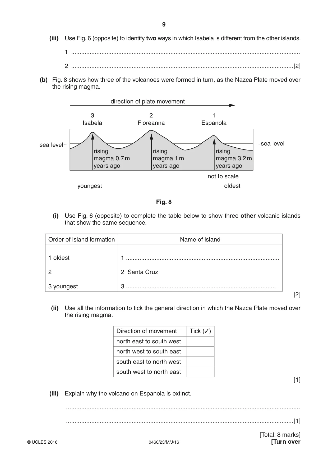
9 0460/23/M/J/16 © UCLES 2016 [Turn over (iii) Use Fig. 6 (opposite) to identify two ways in which Isabela is different from the other islands. 1 … 2 …[2] (b) Fig. 8 shows how three of the volcanoes were formed in turn, as the Nazca Plate moved over the rising magma. sea level youngest oldest sea level not to scale direction of plate movement 3 Isabela rising magma 0.7 m years ago rising magma 1 m years ago rising magma 3.2 m years ago 2 Floreanna 1 Espanola Fig. 8 (i) Use Fig. 6 (opposite) to complete the table below to show three other volcanic islands that show the same sequence. Order of island formation Name of island 1 oldest 2 3 youngest 1 … 2 Santa Cruz 3 … [2] (ii) Use all the information to tick the general direction in which the Nazca Plate moved over the rising magma. Direction of movement Tick (3) north east to south west north west to south east south east to north west south west to north east [1] (iii) Explain why the volcano on Espanola is extinct. … …[1] [Total: 8 marks]
Question paper, page 10
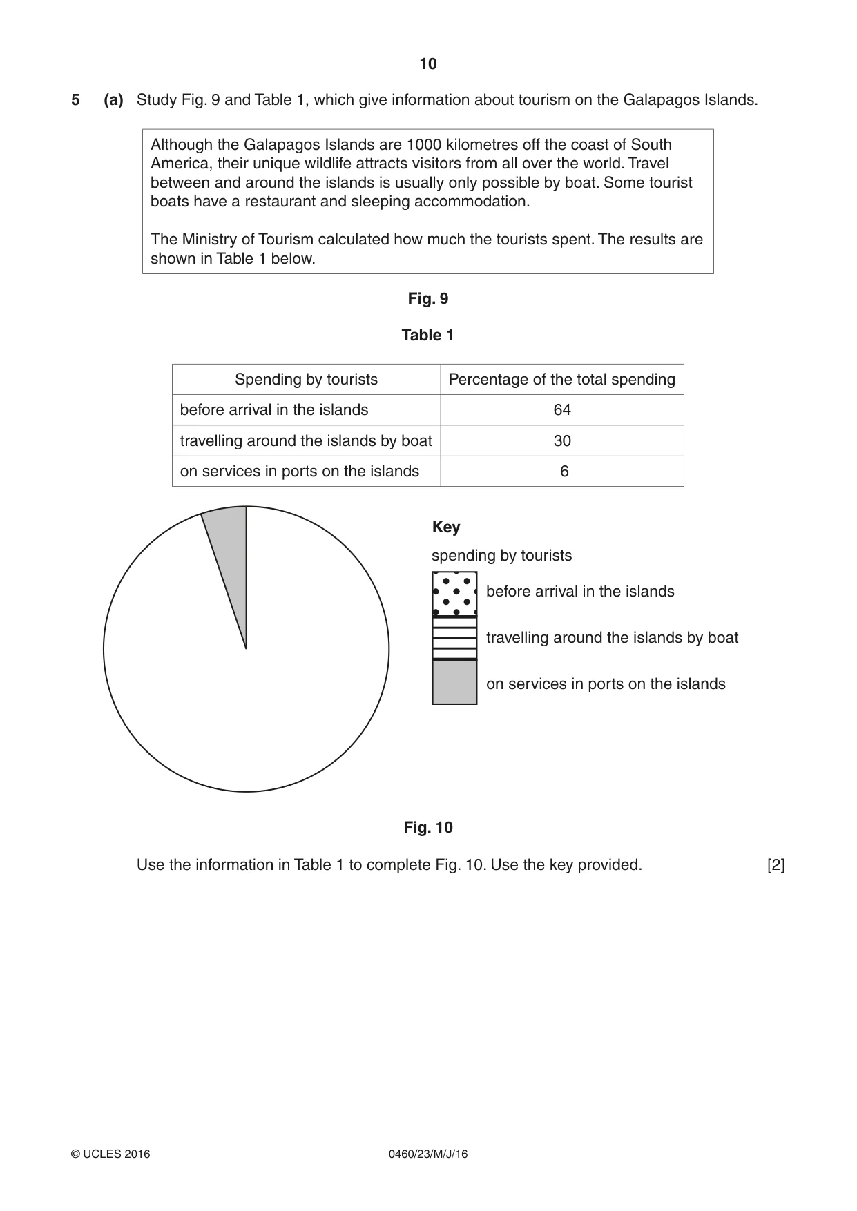
10 0460/23/M/J/16 © UCLES 2016 5 (a) Study Fig. 9 and Table 1, which give information about tourism on the Galapagos Islands. Although the Galapagos Islands are 1000 kilometres off the coast of South America, their unique wildlife attracts visitors from all over the world. Travel between and around the islands is usually only possible by boat. Some tourist boats have a restaurant and sleeping accommodation. The Ministry of Tourism calculated how much the tourists spent. The results are shown in Table 1 below. Fig. 9 Table 1 Spending by tourists Percentage of the total spending before arrival in the islands 64 travelling around the islands by boat 30 on services in ports on the islands 6 Key spending by tourists before arrival in the islands travelling around the islands by boat on services in ports on the islands Fig. 10 Use the information in Table 1 to complete Fig. 10. Use the key provided. [2]
Question paper, page 11
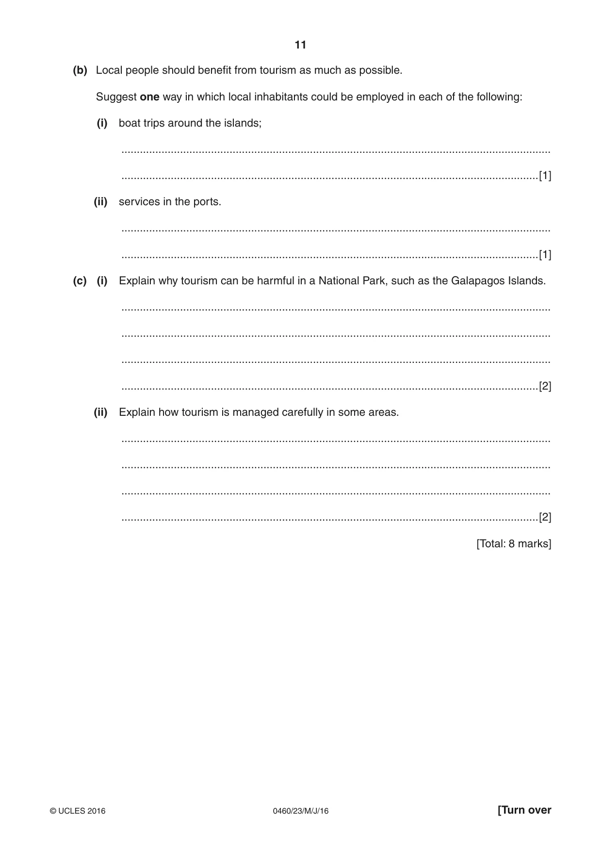
11 0460/23/M/J/16 © UCLES 2016 [Turn over (b) Local people should benefit from tourism as much as possible. Suggest one way in which local inhabitants could be employed in each of the following: (i) boat trips around the islands; … …[1] (ii) services in the ports. … …[1] (c) (i) Explain why tourism can be harmful in a National Park, such as the Galapagos Islands. … … … …[2] (ii) Explain how tourism is managed carefully in some areas. … … … …[2] [Total: 8 marks]
Question paper, page 12
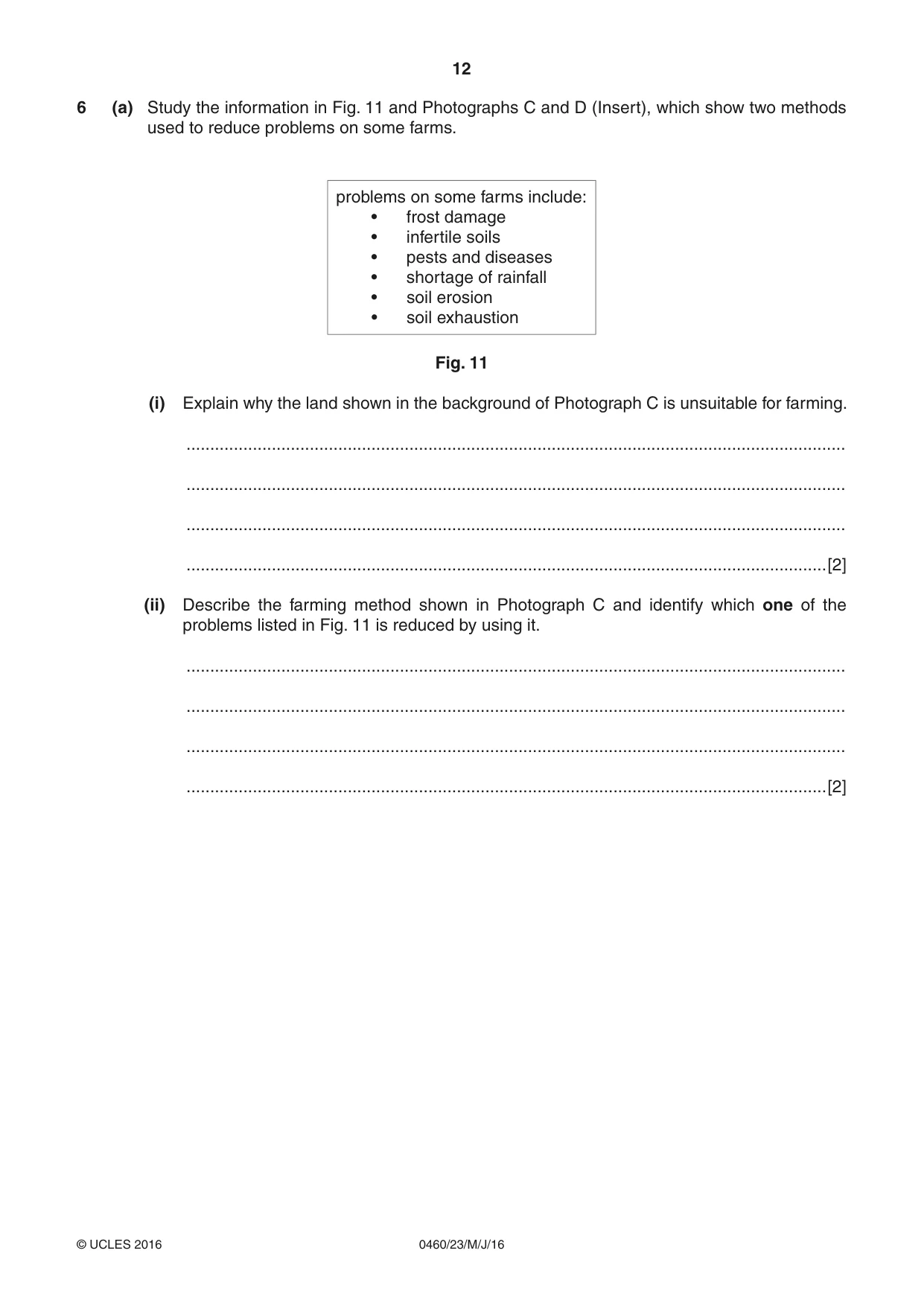
12 0460/23/M/J/16 © UCLES 2016 6 (a) Study the information in Fig. 11 and Photographs C and D (Insert), which show two methods used to reduce problems on some farms. problems on some farms include: • frost damage • infertile soils • pests and diseases • shortage of rainfall • soil erosion • soil exhaustion Fig. 11 (i) Explain why the land shown in the background of Photograph C is unsuitable for farming. … … … …[2] (ii) Describe the farming method shown in Photograph C and identify which one of the problems listed in Fig. 11 is reduced by using it. … … … …[2]
Question paper, page 13
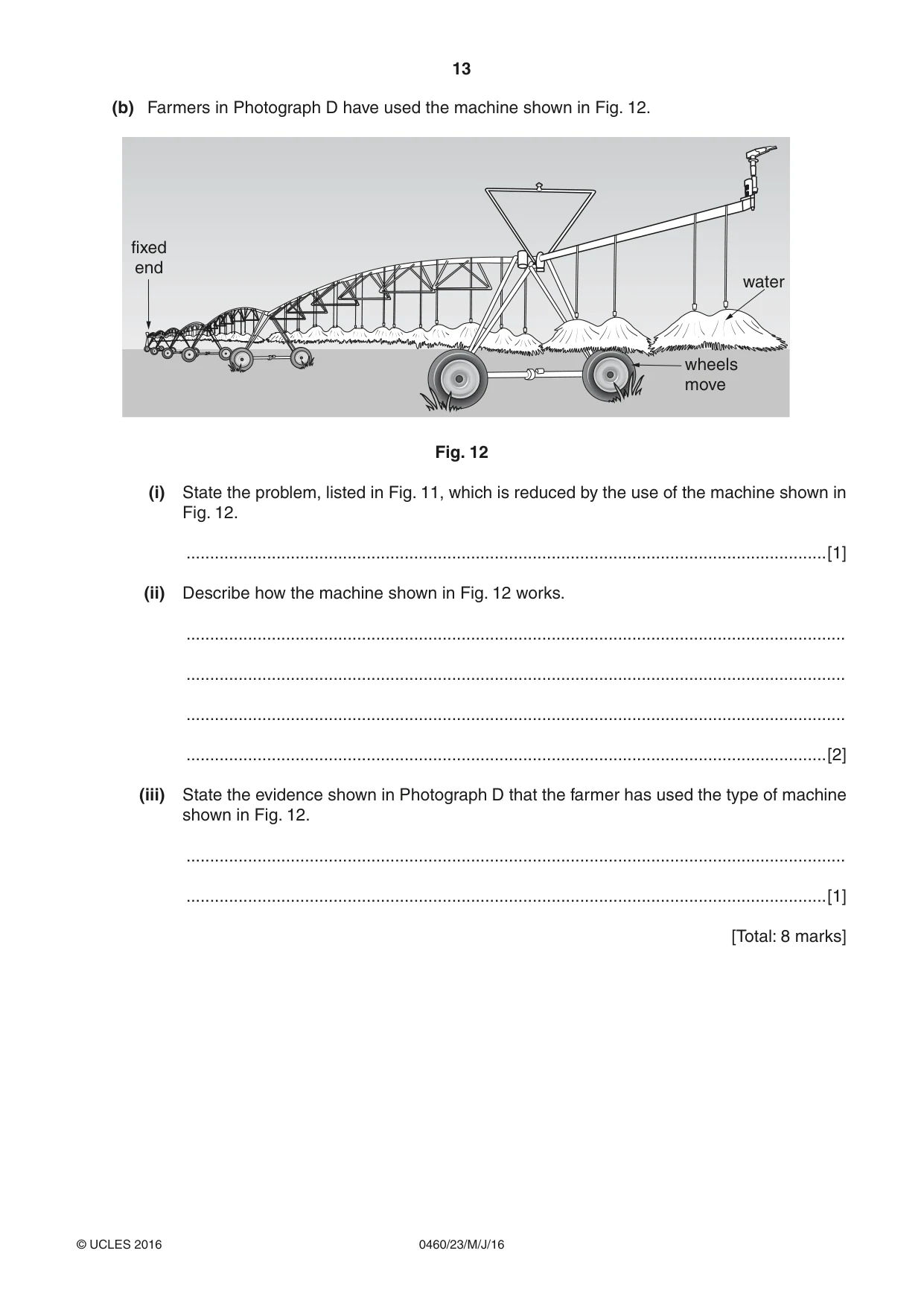
13 0460/23/M/J/16 © UCLES 2016 (b) Farmers in Photograph D have used the machine shown in Fig. 12. Fixed end wheels move Water fixed end water Fig. 12 (i) State the problem, listed in Fig. 11, which is reduced by the use of the machine shown in Fig. 12. …[1] (ii) Describe how the machine shown in Fig. 12 works. … … … …[2] (iii) State the evidence shown in Photograph D that the farmer has used the type of machine shown in Fig. 12. … …[1] [Total: 8 marks]
Question paper, page 14
14 0460/23/M/J/16 © UCLES 2016 Additional Pages If you use the following lined pages to complete the answer(s) to any question(s), the question number(s) must be clearly shown. … … … … … … … … … … … … … … … … … … … … … … … … …
Question paper, page 15
15 0460/23/M/J/16 © UCLES 2016 … … … … … … … … … … … … … … … … … … … … … … … … … … …
Question paper, page 16
16 0460/23/M/J/16 © UCLES 2016 Permission to reproduce items where third-party owned material protected by copyright is included has been sought and cleared where possible. Every reasonable effort has been made by the publisher (UCLES) to trace copyright holders, but if any items requiring clearance have unwittingly been included, the publisher will be pleased to make amends at the earliest possible opportunity. To avoid the issue of disclosure of answer-related information to candidates, all copyright acknowledgements are reproduced online in the Cambridge International Examinations Copyright Acknowledgements Booklet. This is produced for each series of examinations and is freely available to download at www.cie.org.uk after the live examination series. Cambridge International Examinations is part of the Cambridge Assessment Group. Cambridge Assessment is the brand name of University of Cambridge Local Examinations Syndicate (UCLES), which is itself a department of the University of Cambridge. BlANk PAGE
Mark scheme, page 1
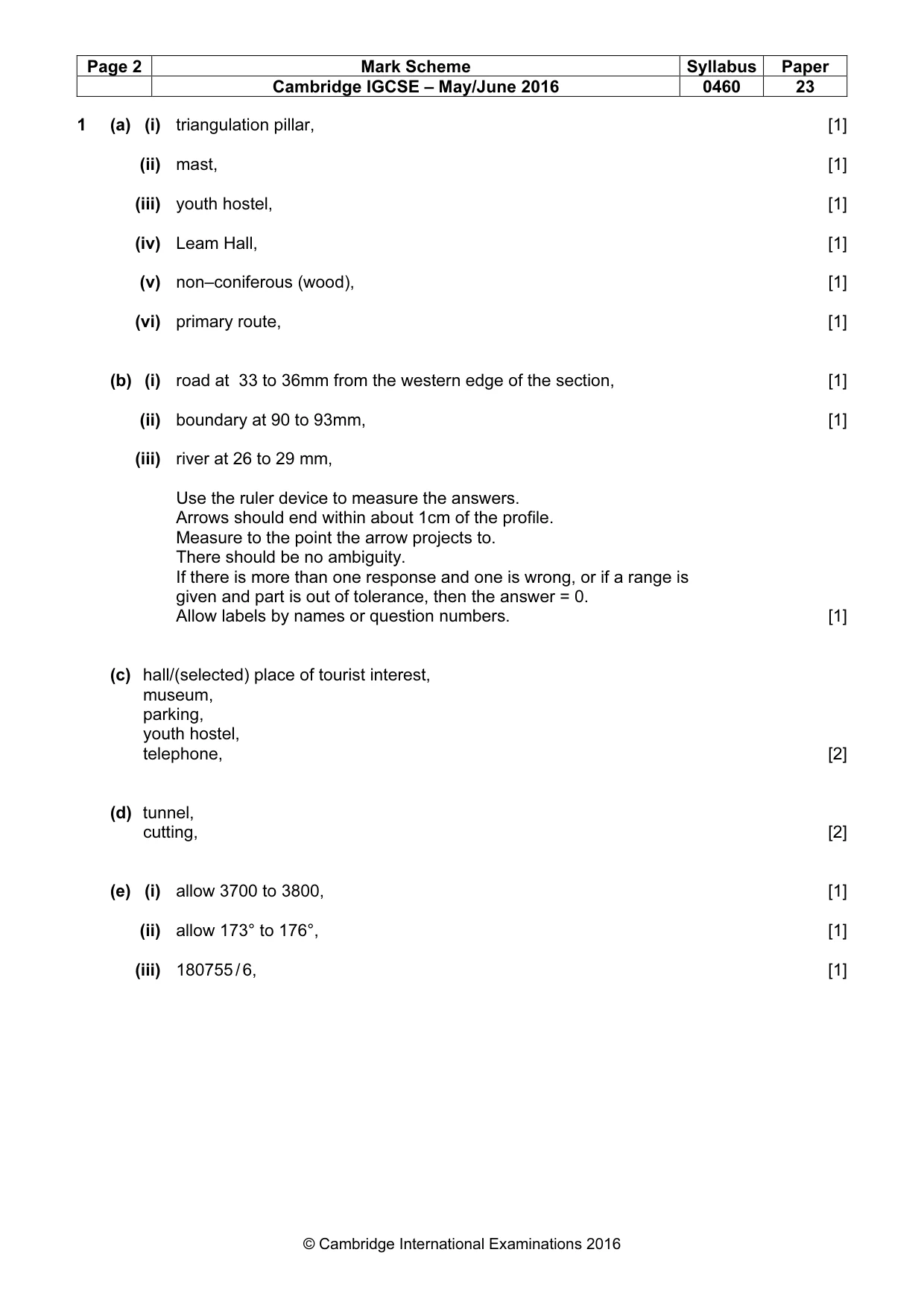
® IGCSE is the registered trademark of Cambridge International Examinations. This syllabus is approved for use in England, Wales and Northern Ireland as a Cambridge International Level 1/Level 2 Certificate. This document consists of 5 printed pages. © UCLES 2016 [Turn over Cambridge International Examinations Cambridge International General Certificate of Secondary Education GEOGRAPHY 0460/23 Paper 2 May/June 2016 MARK SCHEME Maximum Mark: 60 Published This mark scheme is published as an aid to teachers and candidates, to indicate the requirements of the examination. It shows the basis on which Examiners were instructed to award marks. It does not indicate the details of the discussions that took place at an Examiners’ meeting before marking began, which would have considered the acceptability of alternative answers. Mark schemes should be read in conjunction with the question paper and the Principal Examiner Report for Teachers. Cambridge will not enter into discussions about these mark schemes. Cambridge is publishing the mark schemes for the May/June 2016 series for most Cambridge IGCSE®, Cambridge International A and AS Level components and some Cambridge O Level components.
Mark scheme, page 2
Page 2 Mark Scheme Syllabus Paper Cambridge IGCSE – May/June 2016 0460 23 © Cambridge International Examinations 2016 1 (a) (i) triangulation pillar, [1] (ii) mast, [1] (iii) youth hostel, [1] (iv) Leam Hall, [1] (v) non–coniferous (wood), [1] (vi) primary route, [1] (b) (i) road at 33 to 36mm from the western edge of the section, [1] (ii) boundary at 90 to 93mm, [1] (iii) river at 26 to 29 mm, Use the ruler device to measure the answers. Arrows should end within about 1cm of the profile. Measure to the point the arrow projects to. There should be no ambiguity. If there is more than one response and one is wrong, or if a range is given and part is out of tolerance, then the answer = 0. Allow labels by names or question numbers. [1] (c) hall/(selected) place of tourist interest, museum, parking, youth hostel, telephone, [2] (d) tunnel, cutting, [2] (e) (i) allow 3700 to 3800, [1] (ii) allow 173° to 176°, [1] (iii) 180755 / 6, [1]
Mark scheme, page 3
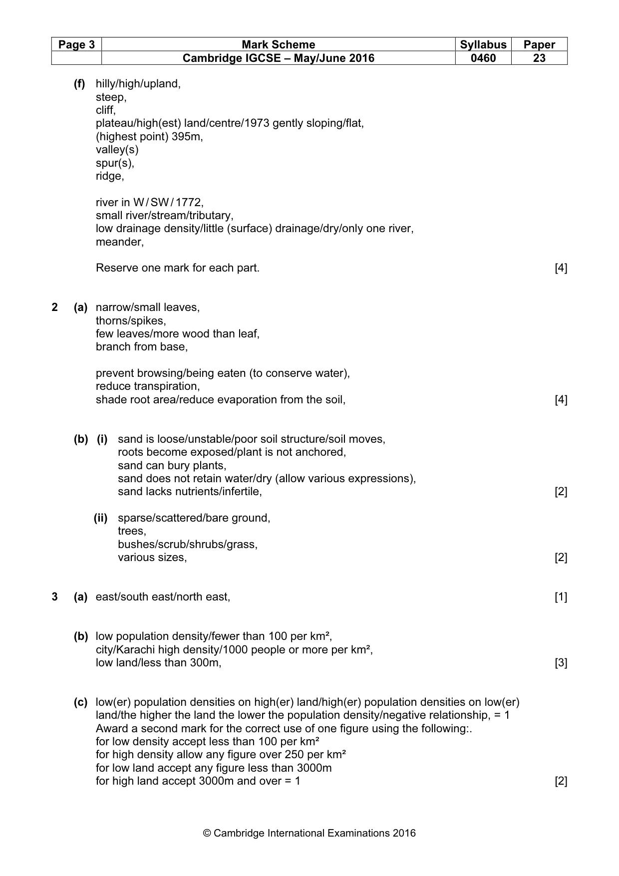
Page 3 Mark Scheme Syllabus Paper Cambridge IGCSE – May/June 2016 0460 23 © Cambridge International Examinations 2016 (f) hilly/high/upland, steep, cliff, plateau/high(est) land/centre/1973 gently sloping/flat, (highest point) 395m, valley(s) spur(s), ridge, river in W / SW / 1772, small river/stream/tributary, low drainage density/little (surface) drainage/dry/only one river, meander, Reserve one mark for each part. [4] 2 (a) narrow/small leaves, thorns/spikes, few leaves/more wood than leaf, branch from base, prevent browsing/being eaten (to conserve water), reduce transpiration, shade root area/reduce evaporation from the soil, [4] (b) (i) sand is loose/unstable/poor soil structure/soil moves, roots become exposed/plant is not anchored, sand can bury plants, sand does not retain water/dry (allow various expressions), sand lacks nutrients/infertile, [2] (ii) sparse/scattered/bare ground, trees, bushes/scrub/shrubs/grass, various sizes, [2] 3 (a) east/south east/north east, [1] (b) low population density/fewer than 100 per km², city/Karachi high density/1000 people or more per km², low land/less than 300m, [3] (c) low(er) population densities on high(er) land/high(er) population densities on low(er) land/the higher the land the lower the population density/negative relationship, = 1 Award a second mark for the correct use of one figure using the following:. for low density accept less than 100 per km² for high density allow any figure over 250 per km² for low land accept any figure less than 3000m for high land accept 3000m and over = 1 [2]
Mark scheme, page 4
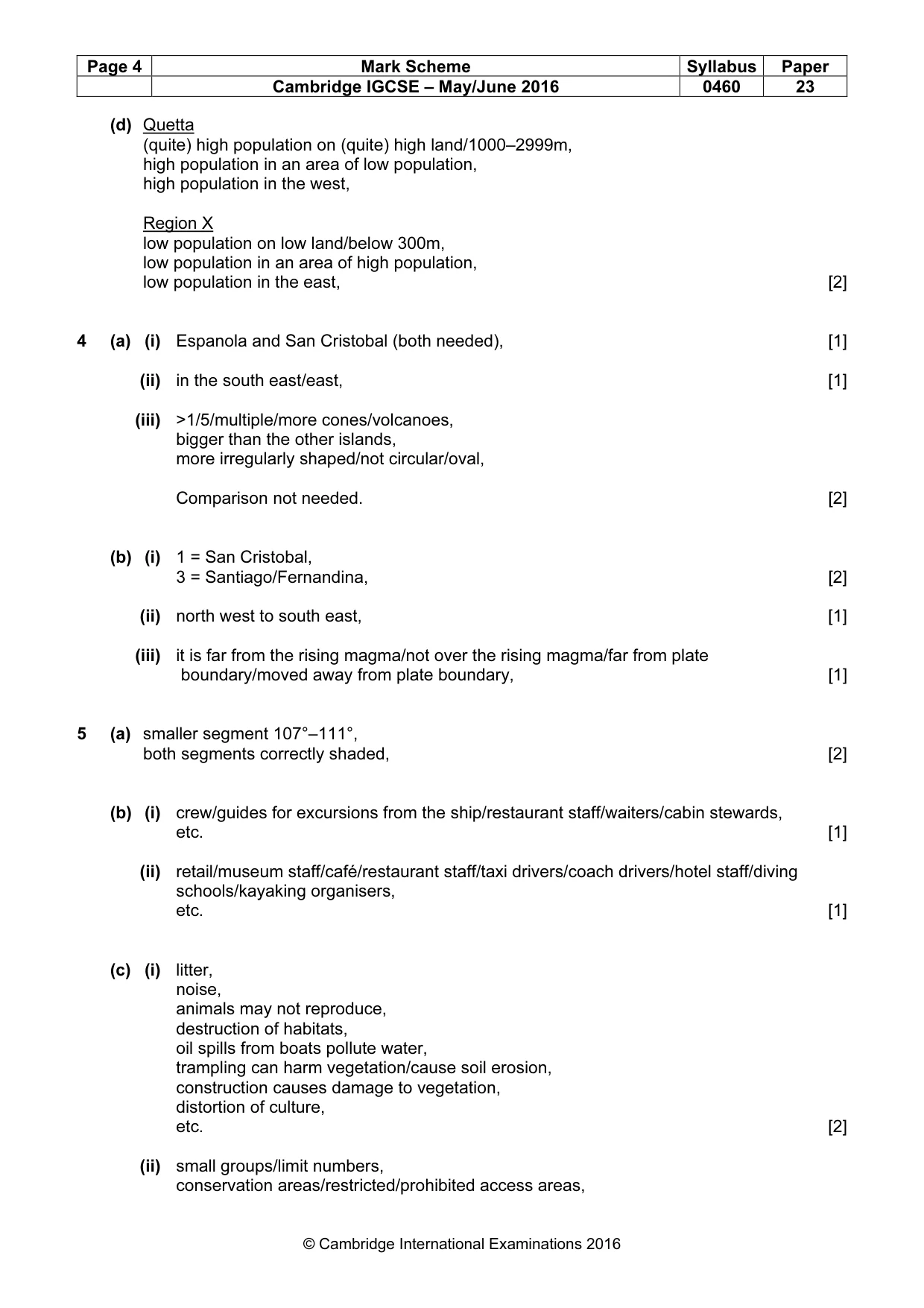
Page 4 Mark Scheme Syllabus Paper Cambridge IGCSE – May/June 2016 0460 23 © Cambridge International Examinations 2016 (d) Quetta (quite) high population on (quite) high land/1000–2999m, high population in an area of low population, high population in the west, Region X low population on low land/below 300m, low population in an area of high population, low population in the east, [2] 4 (a) (i) Espanola and San Cristobal (both needed), [1] (ii) in the south east/east, [1] (iii) >1/5/multiple/more cones/volcanoes, bigger than the other islands, more irregularly shaped/not circular/oval, Comparison not needed. [2] (b) (i) 1 = San Cristobal, 3 = Santiago/Fernandina, [2] (ii) north west to south east, [1] (iii) it is far from the rising magma/not over the rising magma/far from plate boundary/moved away from plate boundary, [1] 5 (a) smaller segment 107°–111°, both segments correctly shaded, [2] (b) (i) crew/guides for excursions from the ship/restaurant staff/waiters/cabin stewards, etc. [1] (ii) retail/museum staff/café/restaurant staff/taxi drivers/coach drivers/hotel staff/diving schools/kayaking organisers, etc. [1] (c) (i) litter, noise, animals may not reproduce, destruction of habitats, oil spills from boats pollute water, trampling can harm vegetation/cause soil erosion, construction causes damage to vegetation, distortion of culture, etc. [2] (ii) small groups/limit numbers, conservation areas/restricted/prohibited access areas,
Mark scheme, page 5
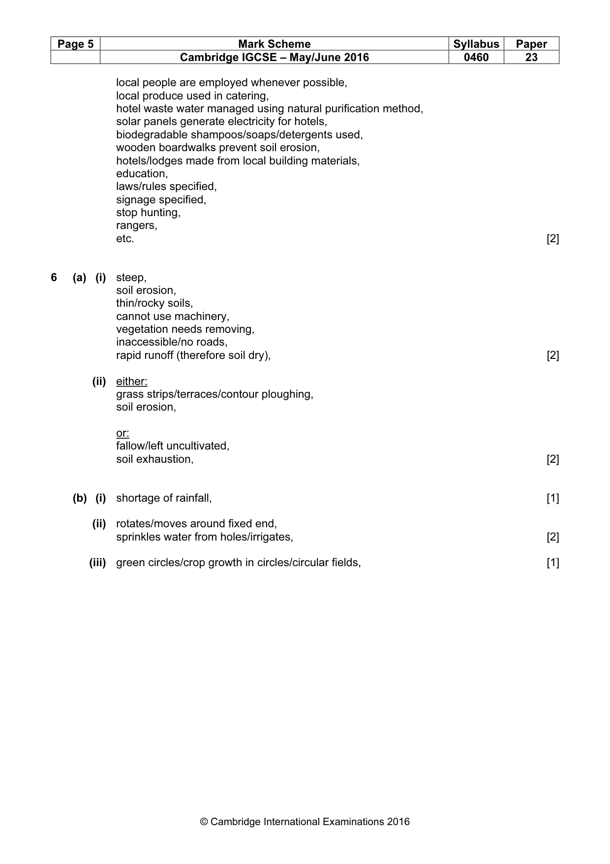
Page 5 Mark Scheme Syllabus Paper Cambridge IGCSE – May/June 2016 0460 23 © Cambridge International Examinations 2016 local people are employed whenever possible, local produce used in catering, hotel waste water managed using natural purification method, solar panels generate electricity for hotels, biodegradable shampoos/soaps/detergents used, wooden boardwalks prevent soil erosion, hotels/lodges made from local building materials, education, laws/rules specified, signage specified, stop hunting, rangers, etc. [2] 6 (a) (i) steep, soil erosion, thin/rocky soils, cannot use machinery, vegetation needs removing, inaccessible/no roads, rapid runoff (therefore soil dry), [2] (ii) either: grass strips/terraces/contour ploughing, soil erosion, or: fallow/left uncultivated, soil exhaustion, [2] (b) (i) shortage of rainfall, [1] (ii) rotates/moves around fixed end, sprinkles water from holes/irrigates, [2] (iii) green circles/crop growth in circles/circular fields, [1]
What you needed in this session
Cambridge’s own grade thresholds for 2016 May/June, Paper 2 · Variant 3. A higher threshold means an easier paper — the bar moves with how the cohort did.