Cambridge IGCSE Geography 0460 — 2016 May/June Paper 2 · Variant 2
0460/22/M/J/16 · 60 marks · ≈68 min
The question paper and its mark scheme, free to read here and free to download. This is Cambridge’s own paper, exactly as it was sat.
Question paper20 pages



Mark scheme6 pages
Answers below. Sit the paper first if you are practising.
Paper as text
Question paper, page 1
This document consists of 19 printed pages, 1 blank page and 1 Insert. DC (LK/CGW) 114180/4 © UCLES 2016 [Turn over Cambridge International Examinations Cambridge International General Certificate of Secondary Education * 6 8 3 8 7 0 6 4 6 5 * GEOGRAPHY 0460/22 Paper 2 May/June 2016 1 hour 30 minutes Candidates answer on the Question Paper. Additional Materials: Ruler Protractor Plain paper Calculator 1:50 000 Survey Map Extract is enclosed with this Question Paper. READ THESE INSTRUCTIONS FIRST Write your Centre number, candidate number and name in the spaces provided. Write in dark blue or black pen. You may use an HB pencil for any diagrams or graphs. Do not use staples, paper clips, glue or correction fluid. DO NOT WRITE IN ANY BARCODES. Write your answer to each question in the space provided. If additional space is required, you should use the lined pages at the end of the booklet. The question number(s) must be clearly shown. Answer all questions. The Insert contains Photograph A for Question 3 and Photograph B for Question 6. The Survey Map Extract and the Insert are not required by the Examiner. Sketch maps and diagrams should be drawn whenever they serve to illustrate an answer. At the end of the examination, fasten all your work securely together. The number of marks is given in brackets [ ] at the end of each question or part question. The syllabus is approved for use in England, Wales and Northern Ireland as a Cambridge International Level 1/Level 2 Certificate.
Question paper, page 2
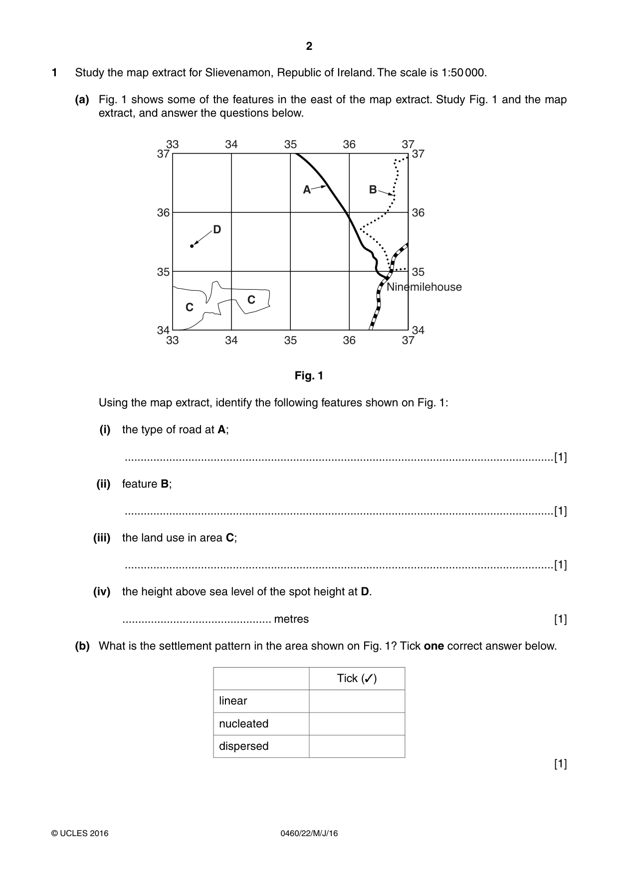
2 0460/22/M/J/16 © UCLES 2016 1 Study the map extract for Slievenamon, Republic of Ireland. The scale is 1:50 000. (a) Fig. 1 shows some of the features in the east of the map extract. Study Fig. 1 and the map extract, and answer the questions below. 36 35 Ninemilehouse 34 37 36 35 34 37 33 34 35 36 37 33 34 C D A B C 35 36 37 Fig. 1 Using the map extract, identify the following features shown on Fig. 1: (i) the type of road at A; …[1] (ii) feature B; …[1] (iii) the land use in area C; …[1] (iv) the height above sea level of the spot height at D. … metres [1] (b) What is the settlement pattern in the area shown on Fig. 1? Tick one correct answer below. Tick (✓) linear nucleated dispersed [1]
Question paper, page 3
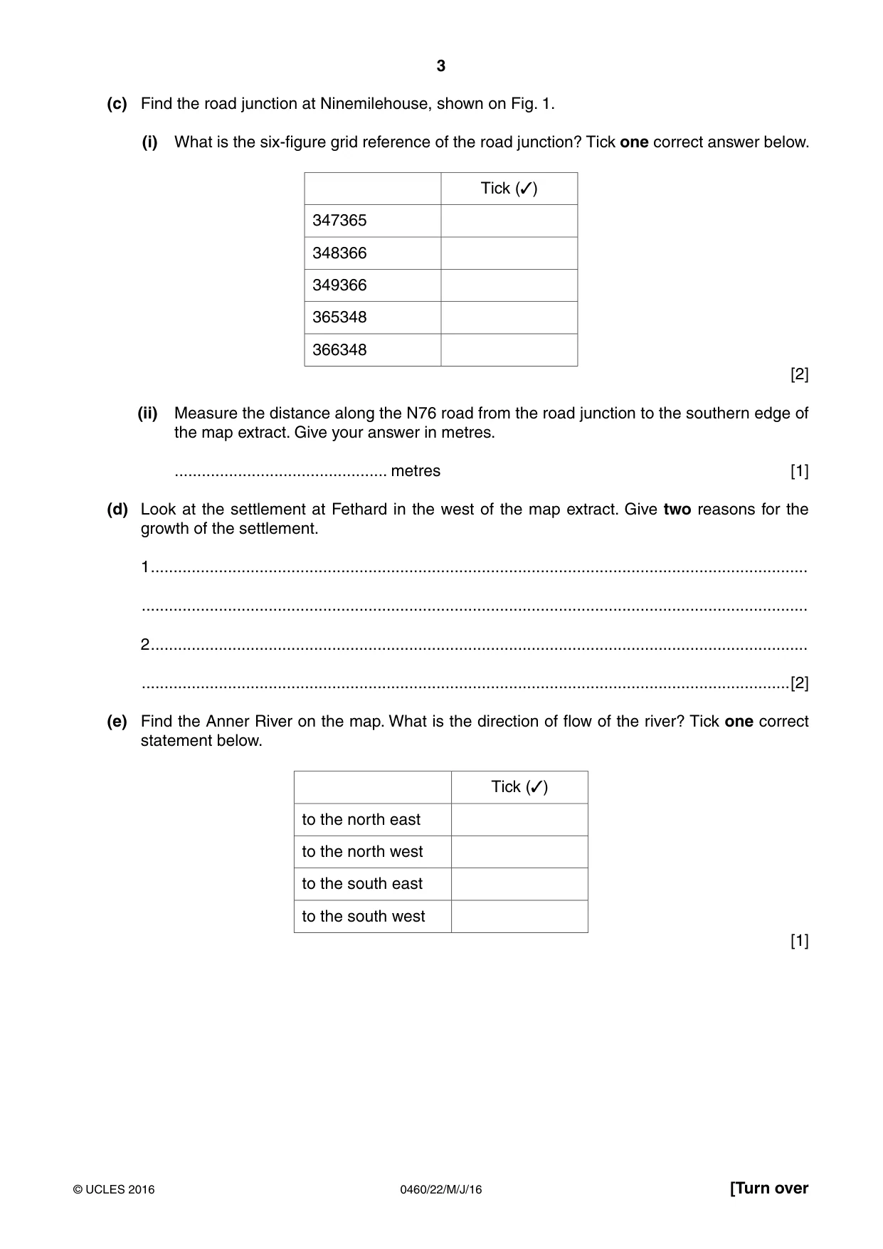
3 0460/22/M/J/16 © UCLES 2016 [Turn over (c) Find the road junction at Ninemilehouse, shown on Fig. 1. (i) What is the six-figure grid reference of the road junction? Tick one correct answer below. Tick (✓) 347365 348366 349366 365348 366348 [2] (ii) Measure the distance along the N76 road from the road junction to the southern edge of the map extract. Give your answer in metres. … metres [1] (d) Look at the settlement at Fethard in the west of the map extract. Give two reasons for the growth of the settlement. 1 … … 2 … …[2] (e) Find the Anner River on the map. What is the direction of flow of the river? Tick one correct statement below. Tick (✓) to the north east to the north west to the south east to the south west [1]
Question paper, page 4
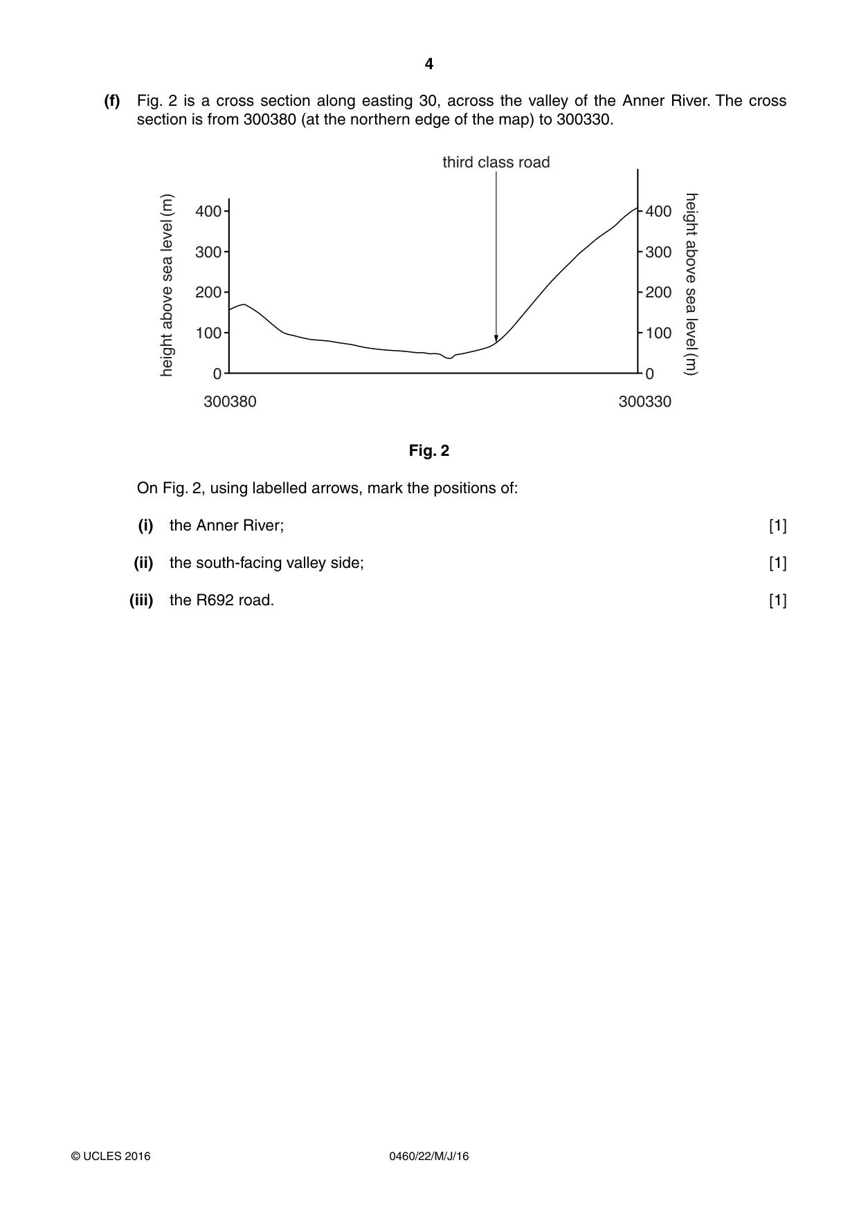
4 0460/22/M/J/16 © UCLES 2016 (f) Fig. 2 is a cross section along easting 30, across the valley of the Anner River. The cross section is from 300380 (at the northern edge of the map) to 300330. 400 300 200 height above sea level (m) height above sea level (m) 100 300380 0 400 300 third class road 200 100 300330 0 Fig. 2 On Fig. 2, using labelled arrows, mark the positions of: (i) the Anner River; [1] (ii) the south-facing valley side; [1] (iii) the R692 road. [1]
Question paper, page 5
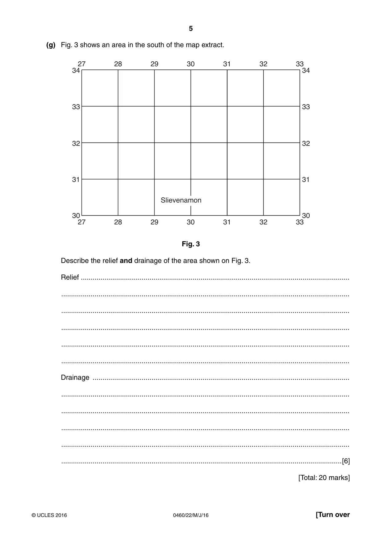
5 0460/22/M/J/16 © UCLES 2016 [Turn over (g) Fig. 3 shows an area in the south of the map extract. 33 32 31 30 34 33 32 31 30 34 27 28 29 30 31 32 33 27 28 29 30 31 32 33 Slievenamon Fig. 3 Describe the relief and drainage of the area shown on Fig. 3. Relief … … … … … … Drainage … … … … … …[6] [Total: 20 marks]
Question paper, page 6
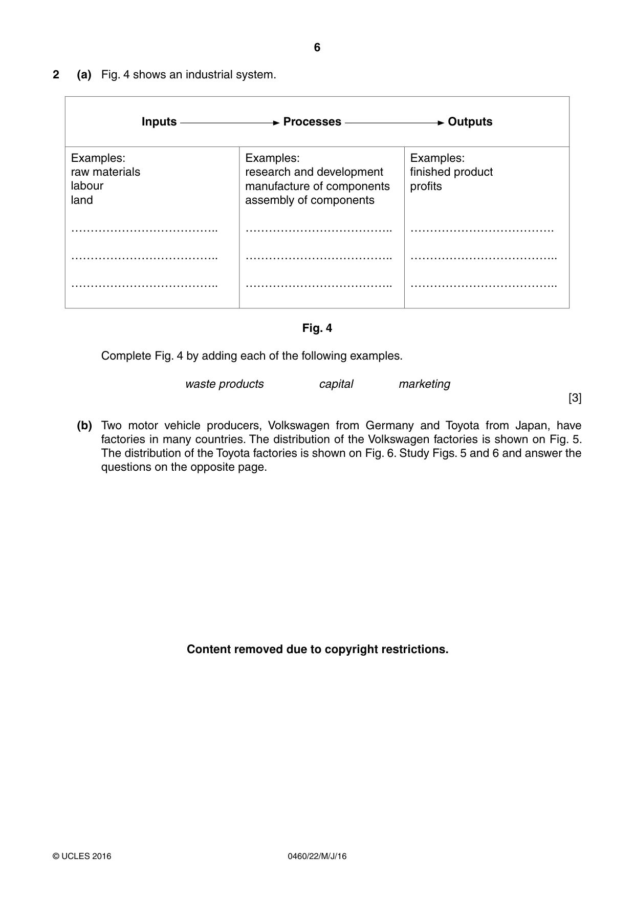
6 0460/22/M/J/16 © UCLES 2016 2 (a) Fig. 4 shows an industrial system. Inputs Processes Outputs Examples: raw materials labour land ……………………………….. ……………………………….. ……………………………….. Examples: research and development manufacture of components assembly of components ……………………………….. ……………………………….. ……………………………….. Examples: finished product profits ………………………………. ……………………………….. ……………………………….. Fig. 4 Complete Fig. 4 by adding each of the following examples. waste products capital marketing [3] (b) Two motor vehicle producers, Volkswagen from Germany and Toyota from Japan, have factories in many countries. The distribution of the Volkswagen factories is shown on Fig. 5. The distribution of the Toyota factories is shown on Fig. 6. Study Figs. 5 and 6 and answer the questions on the opposite page. Content removed due to copyright restrictions.
Question paper, page 7
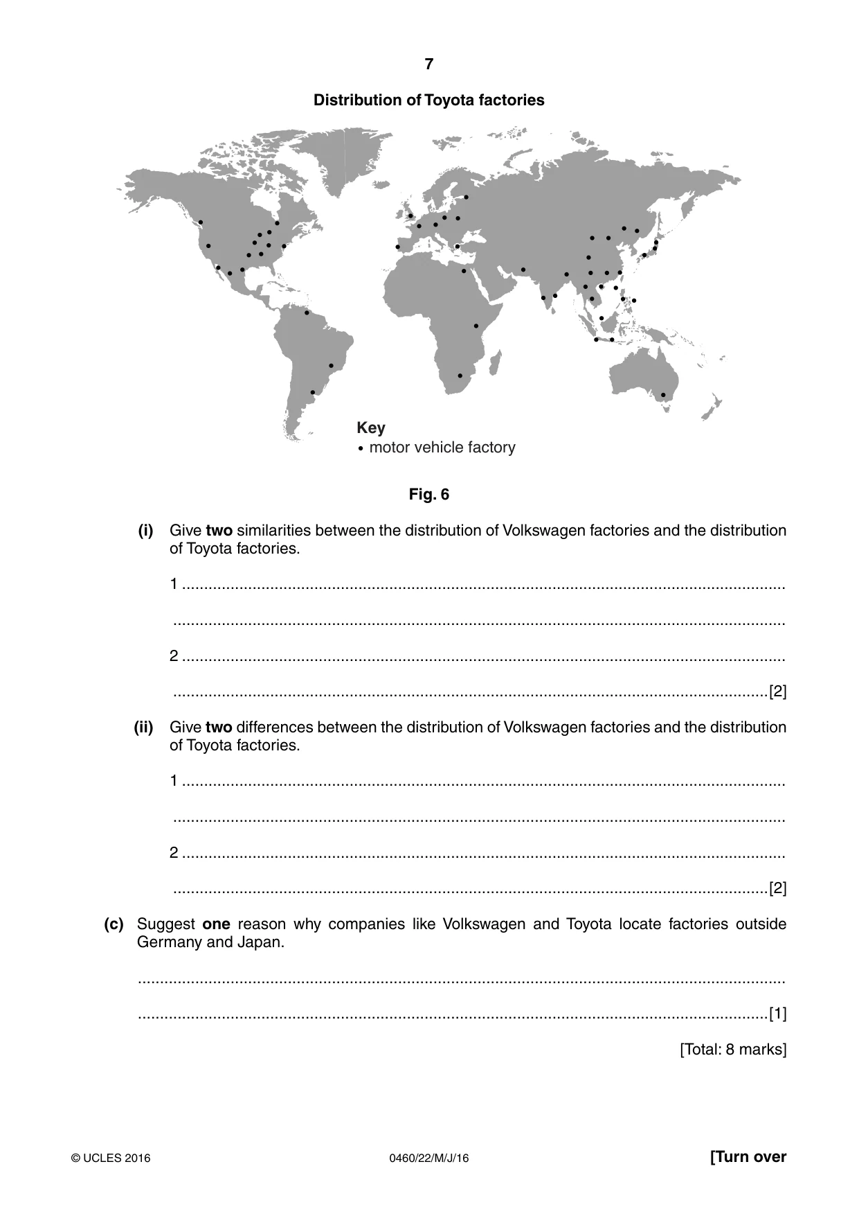
7 0460/22/M/J/16 © UCLES 2016 [Turn over Distribution of Toyota factories motor vehicle factory Key Fig. 6 (i) Give two similarities between the distribution of Volkswagen factories and the distribution of Toyota factories. 1 … … 2 … …[2] (ii) Give two differences between the distribution of Volkswagen factories and the distribution of Toyota factories. 1 … … 2 … …[2] (c) Suggest one reason why companies like Volkswagen and Toyota locate factories outside Germany and Japan. … …[1] [Total: 8 marks]
Question paper, page 8
8 0460/22/M/J/16 © UCLES 2016 3 (a) Study Photograph A (Insert), which shows an area of tropical rainforest. Describe the vegetation seen in the photograph. … … … … … … … … … … … …[6]
Question paper, page 9
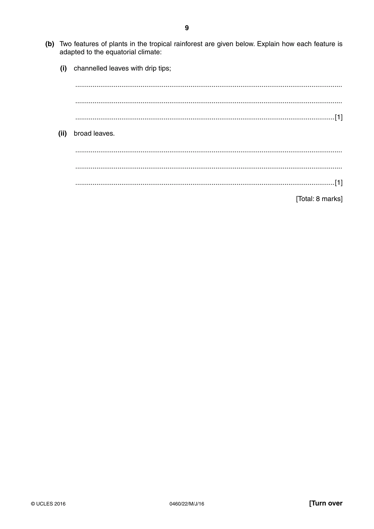
9 0460/22/M/J/16 © UCLES 2016 [Turn over (b) Two features of plants in the tropical rainforest are given below. Explain how each feature is adapted to the equatorial climate: (i) channelled leaves with drip tips; … … …[1] (ii) broad leaves. … … …[1] [Total: 8 marks]
Question paper, page 10
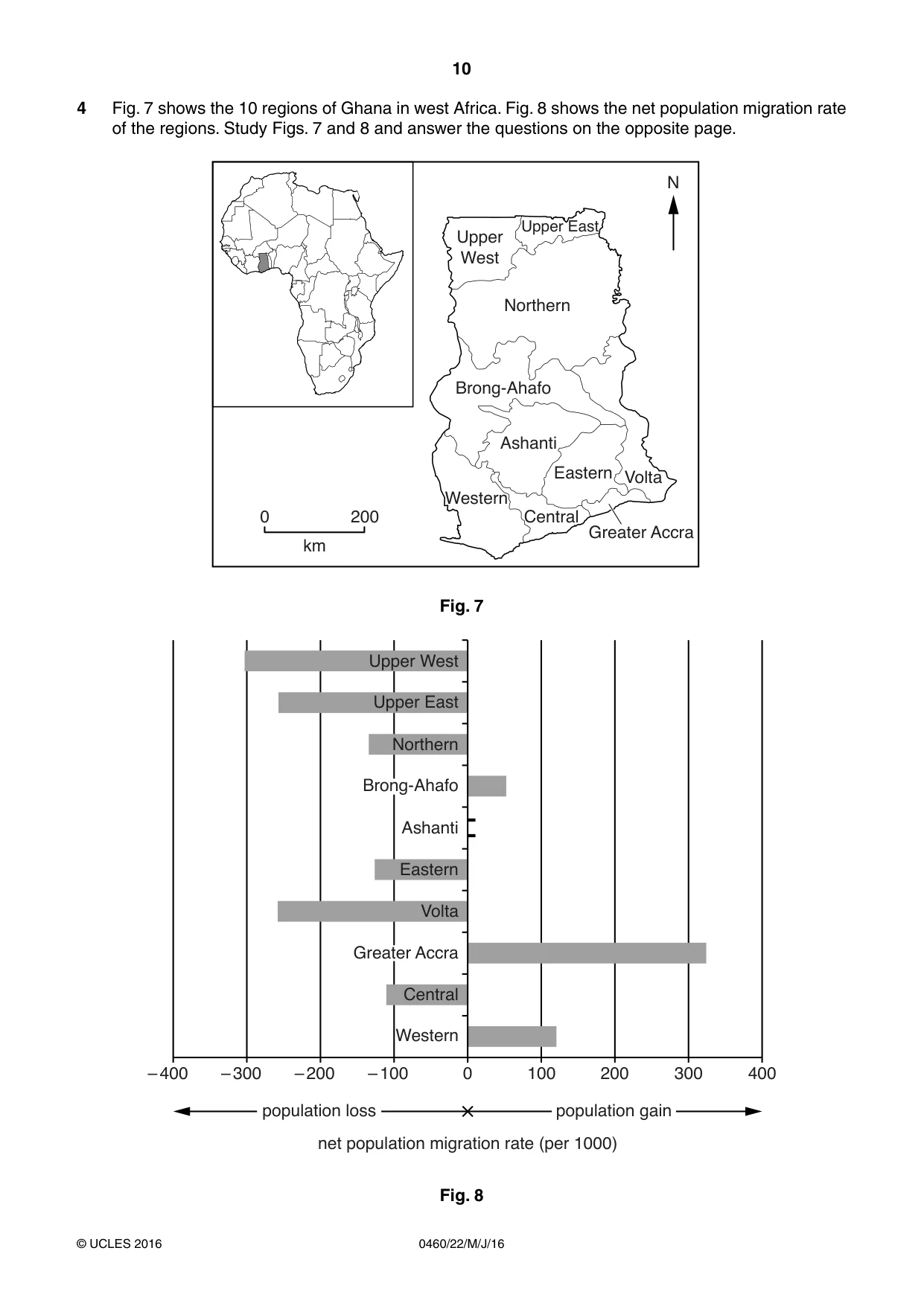
10 0460/22/M/J/16 © UCLES 2016 4 Fig. 7 shows the 10 regions of Ghana in west Africa. Fig. 8 shows the net population migration rate of the regions. Study Figs. 7 and 8 and answer the questions on the opposite page. 0 200 Greater Accra Central Western Ashanti Eastern Volta Brong-Ahafo Northern N Upper West Upper East km Fig. 7 Central 0 net population migration rate (per 1000) – 100 100 200 300 400 – 200 – 300 – 400 Western Ashanti Northern Upper East Upper West Eastern Volta population gain population loss Greater Accra Brong-Ahafo Fig. 8
Question paper, page 11
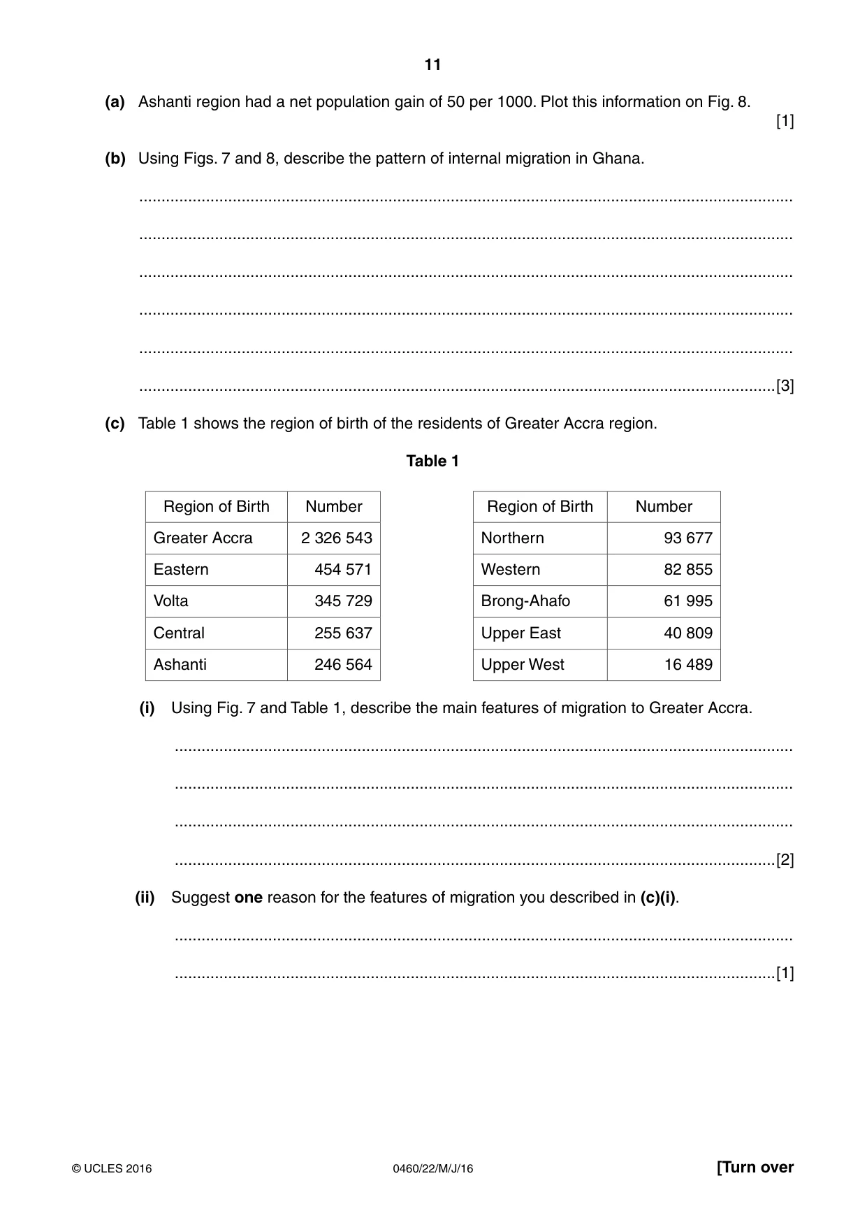
11 0460/22/M/J/16 © UCLES 2016 [Turn over (a) Ashanti region had a net population gain of 50 per 1000. Plot this information on Fig. 8. [1] (b) Using Figs. 7 and 8, describe the pattern of internal migration in Ghana. … … … … … …[3] (c) Table 1 shows the region of birth of the residents of Greater Accra region. Table 1 Region of Birth Number Region of Birth Number Greater Accra 2 326 543 Northern 93 677 Eastern 454 571 Western 82 855 Volta 345 729 Brong-Ahafo 61 995 Central 255 637 Upper East 40 809 Ashanti 246 564 Upper West 16 489 (i) Using Fig. 7 and Table 1, describe the main features of migration to Greater Accra. … … … …[2] (ii) Suggest one reason for the features of migration you described in (c)(i). … …[1]
Question paper, page 12
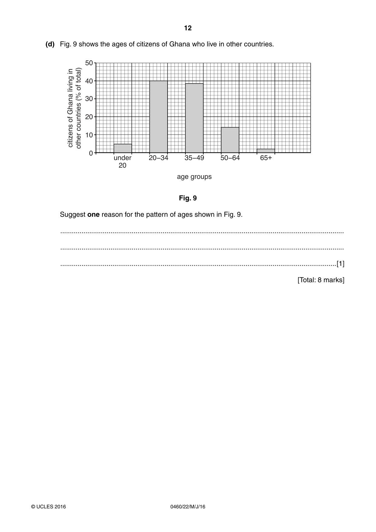
12 0460/22/M/J/16 © UCLES 2016 (d) Fig. 9 shows the ages of citizens of Ghana who live in other countries. under 20 20ï34 0 10 20 citizens of Ghana living in other countries (% of total) 30 40 50 35ï49 age groups 50ï64 65+ Fig. 9 Suggest one reason for the pattern of ages shown in Fig. 9. … … …[1] [Total: 8 marks]
Question paper, page 13
13 0460/22/M/J/16 © UCLES 2016 [Turn over TURN PAGE FOR QUESTION 5
Question paper, page 14
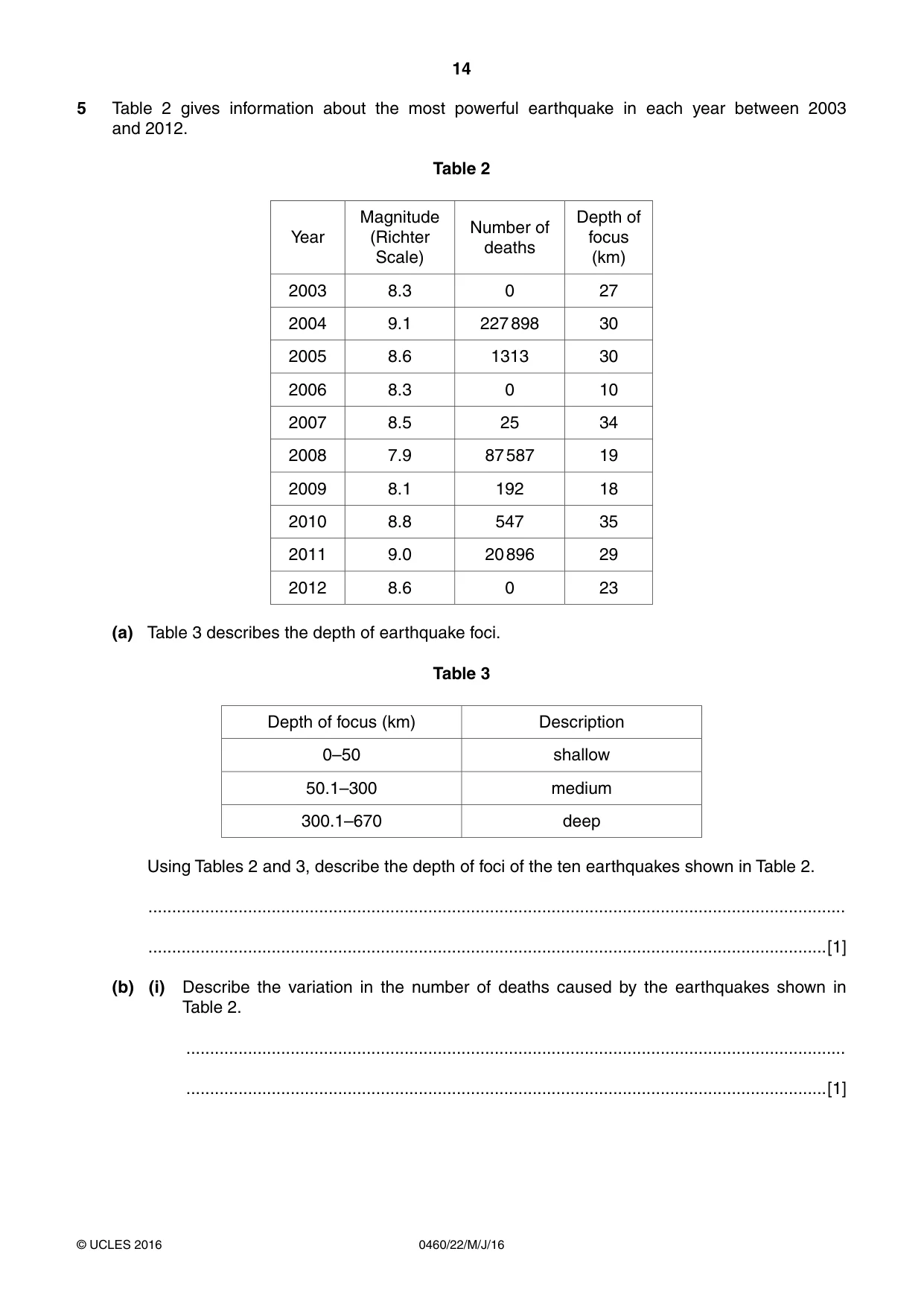
14 0460/22/M/J/16 © UCLES 2016 5 Table 2 gives information about the most powerful earthquake in each year between 2003 and 2012. Table 2 Year Magnitude (Richter Scale) Number of deaths Depth of focus (km) 2003 8.3 0 27 2004 9.1 227 898 30 2005 8.6 1313 30 2006 8.3 0 10 2007 8.5 25 34 2008 7.9 87 587 19 2009 8.1 192 18 2010 8.8 547 35 2011 9.0 20 896 29 2012 8.6 0 23 (a) Table 3 describes the depth of earthquake foci. Table 3 Depth of focus (km) Description 0–50 shallow 50.1–300 medium 300.1–670 deep Using Tables 2 and 3, describe the depth of foci of the ten earthquakes shown in Table 2. … …[1] (b) (i) Describe the variation in the number of deaths caused by the earthquakes shown in Table 2. … …[1]
Question paper, page 15
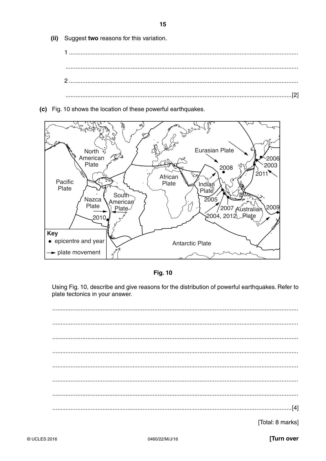
15 0460/22/M/J/16 © UCLES 2016 [Turn over (ii) Suggest two reasons for this variation. 1 … … 2 … …[2] (c) Fig. 10 shows the location of these powerful earthquakes. Antarctic Plate African Plate North American Plate 2008 2007 2009 2011 2003 2006 2005 2010 2004, 2012 Australian Plate South American Plate Indian Plate Eurasian Plate Nazca Plate Pacific Plate Key epicentre and year plate movement Fig. 10 Using Fig. 10, describe and give reasons for the distribution of powerful earthquakes. Refer to plate tectonics in your answer. … … … … … … … …[4] [Total: 8 marks]
Question paper, page 16
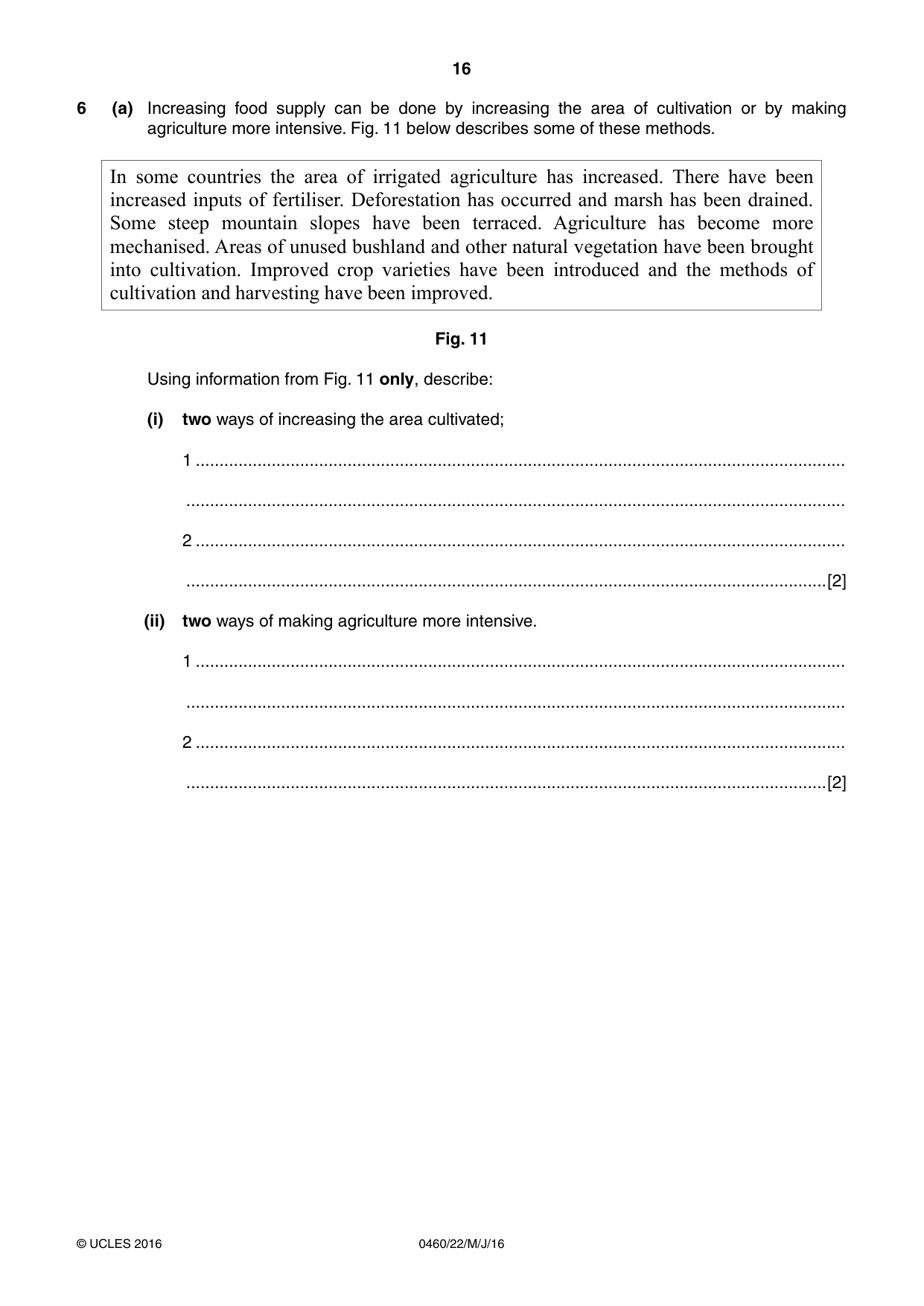
16 0460/22/M/J/16 © UCLES 2016 6 (a) Increasing food supply can be done by increasing the area of cultivation or by making agriculture more intensive. Fig. 11 below describes some of these methods. In some countries the area of irrigated agriculture has increased. There have been increased inputs of fertiliser. Deforestation has occurred and marsh has been drained. Some steep mountain slopes have been terraced. Agriculture has become more mechanised. Areas of unused bushland and other natural vegetation have been brought into cultivation. Improved crop varieties have been introduced and the methods of cultivation and harvesting have been improved. Fig. 11 Using information from Fig. 11 only, describe: (i) two ways of increasing the area cultivated; 1 … … 2 … …[2] (ii) two ways of making agriculture more intensive. 1 … … 2 … …[2]
Question paper, page 17
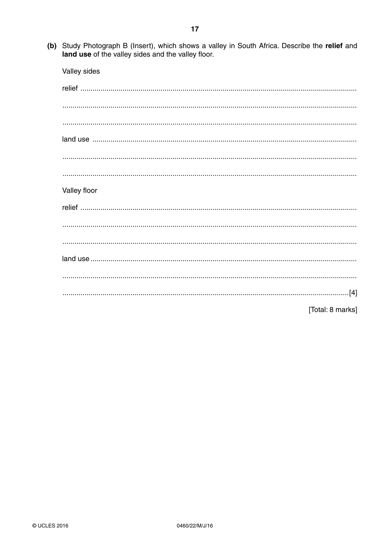
17 0460/22/M/J/16 © UCLES 2016 (b) Study Photograph B (Insert), which shows a valley in South Africa. Describe the relief and land use of the valley sides and the valley floor. Valley sides relief … … … land use … … … Valley floor relief … … … land use … … …[4] [Total: 8 marks]
Question paper, page 18
18 0460/22/M/J/16 © UCLES 2016 Additional Pages If you use the following lined pages to complete the answer(s) to any question(s), the question number(s) must be clearly shown. … … … … … … … … … … … … … … … … … … … … … … … … … …
Question paper, page 19
19 0460/22/M/J/16 © UCLES 2016 … … … … … … … … … … … … … … … … … … … … … … … … … … …
Question paper, page 20
20 0460/22/M/J/16 © UCLES 2016 Permission to reproduce items where third-party owned material protected by copyright is included has been sought and cleared where possible. Every reasonable effort has been made by the publisher (UCLES) to trace copyright holders, but if any items requiring clearance have unwittingly been included, the publisher will be pleased to make amends at the earliest possible opportunity. To avoid the issue of disclosure of answer-related information to candidates, all copyright acknowledgements are reproduced online in the Cambridge International Examinations Copyright Acknowledgements Booklet. This is produced for each series of examinations and is freely available to download at www.cie.org.uk after the live examination series. Cambridge International Examinations is part of the Cambridge Assessment Group. Cambridge Assessment is the brand name of University of Cambridge Local Examinations Syndicate (UCLES), which is itself a department of the University of Cambridge. BLANK PAGE
Mark scheme, page 1
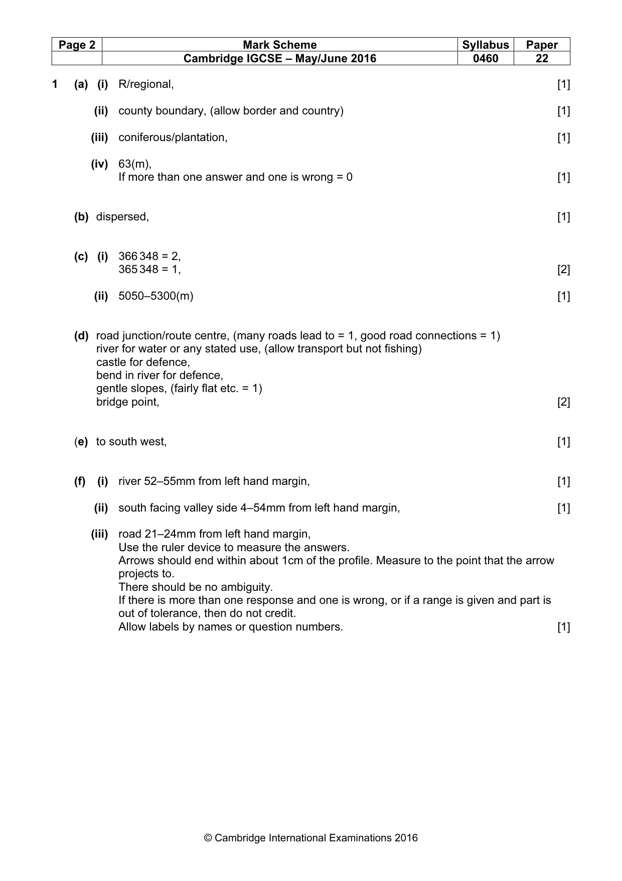
® IGCSE is the registered trademark of Cambridge International Examinations. This syllabus is approved for use in England, Wales and Northern Ireland as a Cambridge International Level 1/Level 2 Certificate. This document consists of 6 printed pages. © UCLES 2016 [Turn over Cambridge International Examinations Cambridge International General Certificate of Secondary Education GEOGRAPHY 0460/22 Paper 2 May/June 2016 MARK SCHEME Maximum Mark: 60 Published This mark scheme is published as an aid to teachers and candidates, to indicate the requirements of the examination. It shows the basis on which Examiners were instructed to award marks. It does not indicate the details of the discussions that took place at an Examiners’ meeting before marking began, which would have considered the acceptability of alternative answers. Mark schemes should be read in conjunction with the question paper and the Principal Examiner Report for Teachers. Cambridge will not enter into discussions about these mark schemes. Cambridge is publishing the mark schemes for the May/June 2016 series for most Cambridge IGCSE®, Cambridge International A and AS Level components and some Cambridge O Level components.
Mark scheme, page 2
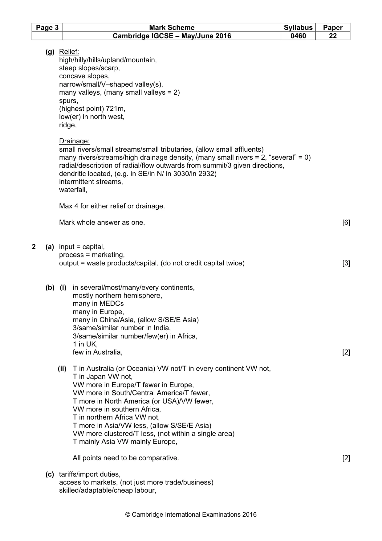
Page 2 Mark Scheme Syllabus Paper Cambridge IGCSE – May/June 2016 0460 22 © Cambridge International Examinations 2016 1 (a) (i) R/regional, [1] (ii) county boundary, (allow border and country) [1] (iii) coniferous/plantation, [1] (iv) 63(m), If more than one answer and one is wrong = 0 [1] (b) dispersed, [1] (c) (i) 366 348 = 2, 365 348 = 1, [2] (ii) 5050–5300(m) [1] (d) road junction/route centre, (many roads lead to = 1, good road connections = 1) river for water or any stated use, (allow transport but not fishing) castle for defence, bend in river for defence, gentle slopes, (fairly flat etc. = 1) bridge point, [2] (e) to south west, [1] (f) (i) river 52–55mm from left hand margin, [1] (ii) south facing valley side 4–54mm from left hand margin, [1] (iii) road 21–24mm from left hand margin, Use the ruler device to measure the answers. Arrows should end within about 1cm of the profile. Measure to the point that the arrow projects to. There should be no ambiguity. If there is more than one response and one is wrong, or if a range is given and part is out of tolerance, then do not credit. Allow labels by names or question numbers. [1]
Mark scheme, page 3
Page 3 Mark Scheme Syllabus Paper Cambridge IGCSE – May/June 2016 0460 22 © Cambridge International Examinations 2016 (g) Relief: high/hilly/hills/upland/mountain, steep slopes/scarp, concave slopes, narrow/small/V–shaped valley(s), many valleys, (many small valleys = 2) spurs, (highest point) 721m, low(er) in north west, ridge, Drainage: small rivers/small streams/small tributaries, (allow small affluents) many rivers/streams/high drainage density, (many small rivers = 2, “several” = 0) radial/description of radial/flow outwards from summit/3 given directions, dendritic located, (e.g. in SE/in N/ in 3030/in 2932) intermittent streams, waterfall, Max 4 for either relief or drainage. Mark whole answer as one. [6] 2 (a) input = capital, process = marketing, output = waste products/capital, (do not credit capital twice) [3] (b) (i) in several/most/many/every continents, mostly northern hemisphere, many in MEDCs many in Europe, many in China/Asia, (allow S/SE/E Asia) 3/same/similar number in India, 3/same/similar number/few(er) in Africa, 1 in UK, few in Australia, [2] (ii) T in Australia (or Oceania) VW not/T in every continent VW not, T in Japan VW not, VW more in Europe/T fewer in Europe, VW more in South/Central America/T fewer, T more in North America (or USA)/VW fewer, VW more in southern Africa, T in northern Africa VW not, T more in Asia/VW less, (allow S/SE/E Asia) VW more clustered/T less, (not within a single area) T mainly Asia VW mainly Europe, All points need to be comparative. [2] (c) tariffs/import duties, access to markets, (not just more trade/business) skilled/adaptable/cheap labour,
Mark scheme, page 4
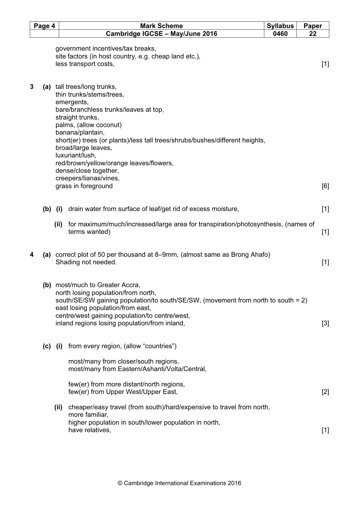
Page 4 Mark Scheme Syllabus Paper Cambridge IGCSE – May/June 2016 0460 22 © Cambridge International Examinations 2016 government incentives/tax breaks, site factors (in host country, e.g. cheap land etc.), less transport costs, [1] 3 (a) tall trees/long trunks, thin trunks/stems/trees, emergents, bare/branchless trunks/leaves at top, straight trunks, palms, (allow coconut) banana/plantain, short(er) trees (or plants)/less tall trees/shrubs/bushes/different heights, broad/large leaves, luxuriant/lush, red/brown/yellow/orange leaves/flowers, dense/close together, creepers/lianas/vines, grass in foreground [6] (b) (i) drain water from surface of leaf/get rid of excess moisture, [1] (ii) for maximum/much/increased/large area for transpiration/photosynthesis, (names of terms wanted) [1] 4 (a) correct plot of 50 per thousand at 8–9mm, (almost same as Brong Ahafo) Shading not needed. [1] (b) most/much to Greater Accra, north losing population/from north, south/SE/SW gaining population/to south/SE/SW, (movement from north to south = 2) east losing population/from east, centre/west gaining population/to centre/west, inland regions losing population/from inland, [3] (c) (i) from every region, (allow “countries”) most/many from closer/south regions, most/many from Eastern/Ashanti/Volta/Central, few(er) from more distant/north regions, few(er) from Upper West/Upper East, [2] (ii) cheaper/easy travel (from south)/hard/expensive to travel from north, more familiar, higher population in south/lower population in north, have relatives, [1]
Mark scheme, page 5
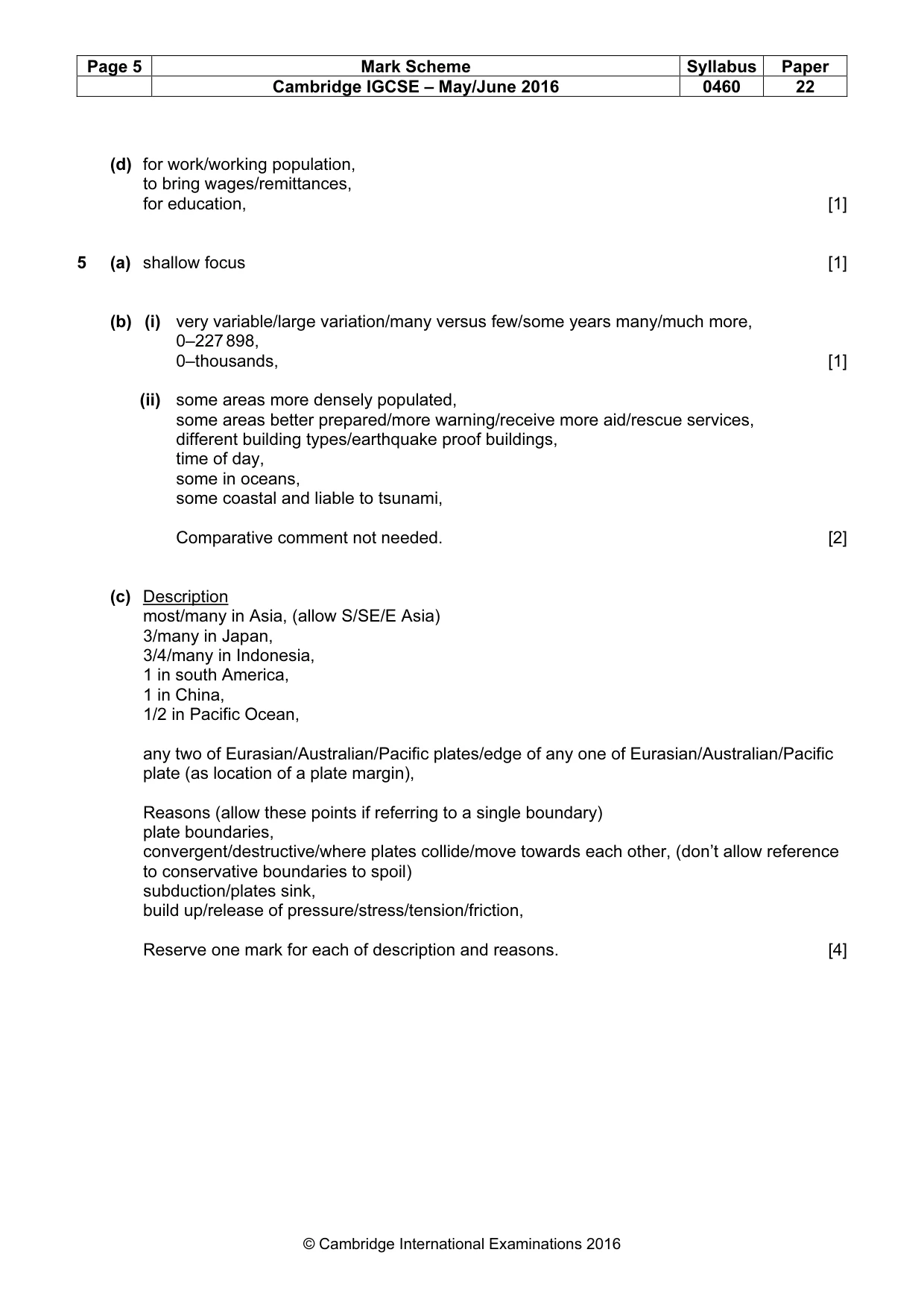
Page 5 Mark Scheme Syllabus Paper Cambridge IGCSE – May/June 2016 0460 22 © Cambridge International Examinations 2016 (d) for work/working population, to bring wages/remittances, for education, [1] 5 (a) shallow focus [1] (b) (i) very variable/large variation/many versus few/some years many/much more, 0–227 898, 0–thousands, [1] (ii) some areas more densely populated, some areas better prepared/more warning/receive more aid/rescue services, different building types/earthquake proof buildings, time of day, some in oceans, some coastal and liable to tsunami, Comparative comment not needed. [2] (c) Description most/many in Asia, (allow S/SE/E Asia) 3/many in Japan, 3/4/many in Indonesia, 1 in south America, 1 in China, 1/2 in Pacific Ocean, any two of Eurasian/Australian/Pacific plates/edge of any one of Eurasian/Australian/Pacific plate (as location of a plate margin), Reasons (allow these points if referring to a single boundary) plate boundaries, convergent/destructive/where plates collide/move towards each other, (don’t allow reference to conservative boundaries to spoil) subduction/plates sink, build up/release of pressure/stress/tension/friction, Reserve one mark for each of description and reasons. [4]
Mark scheme, page 6
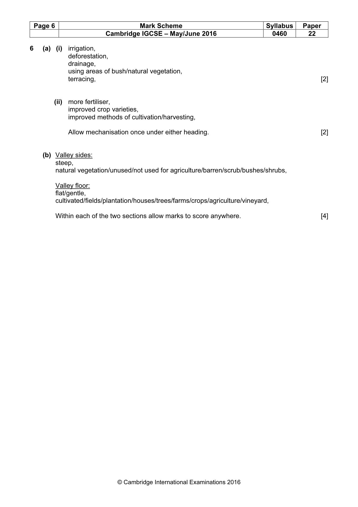
Page 6 Mark Scheme Syllabus Paper Cambridge IGCSE – May/June 2016 0460 22 © Cambridge International Examinations 2016 6 (a) (i) irrigation, deforestation, drainage, using areas of bush/natural vegetation, terracing, [2] (ii) more fertiliser, improved crop varieties, improved methods of cultivation/harvesting, Allow mechanisation once under either heading. [2] (b) Valley sides: steep, natural vegetation/unused/not used for agriculture/barren/scrub/bushes/shrubs, Valley floor: flat/gentle, cultivated/fields/plantation/houses/trees/farms/crops/agriculture/vineyard, Within each of the two sections allow marks to score anywhere. [4]
What you needed in this session
Cambridge’s own grade thresholds for 2016 May/June, Paper 2 · Variant 2. A higher threshold means an easier paper — the bar moves with how the cohort did.