Cambridge IGCSE Geography 0460 — 2014 Oct/Nov Paper 2 · Variant 1
0460/21/O/N/14 · 60 marks · ≈68 min
The question paper and its mark scheme, free to read here and free to download. This is Cambridge’s own paper, exactly as it was sat.
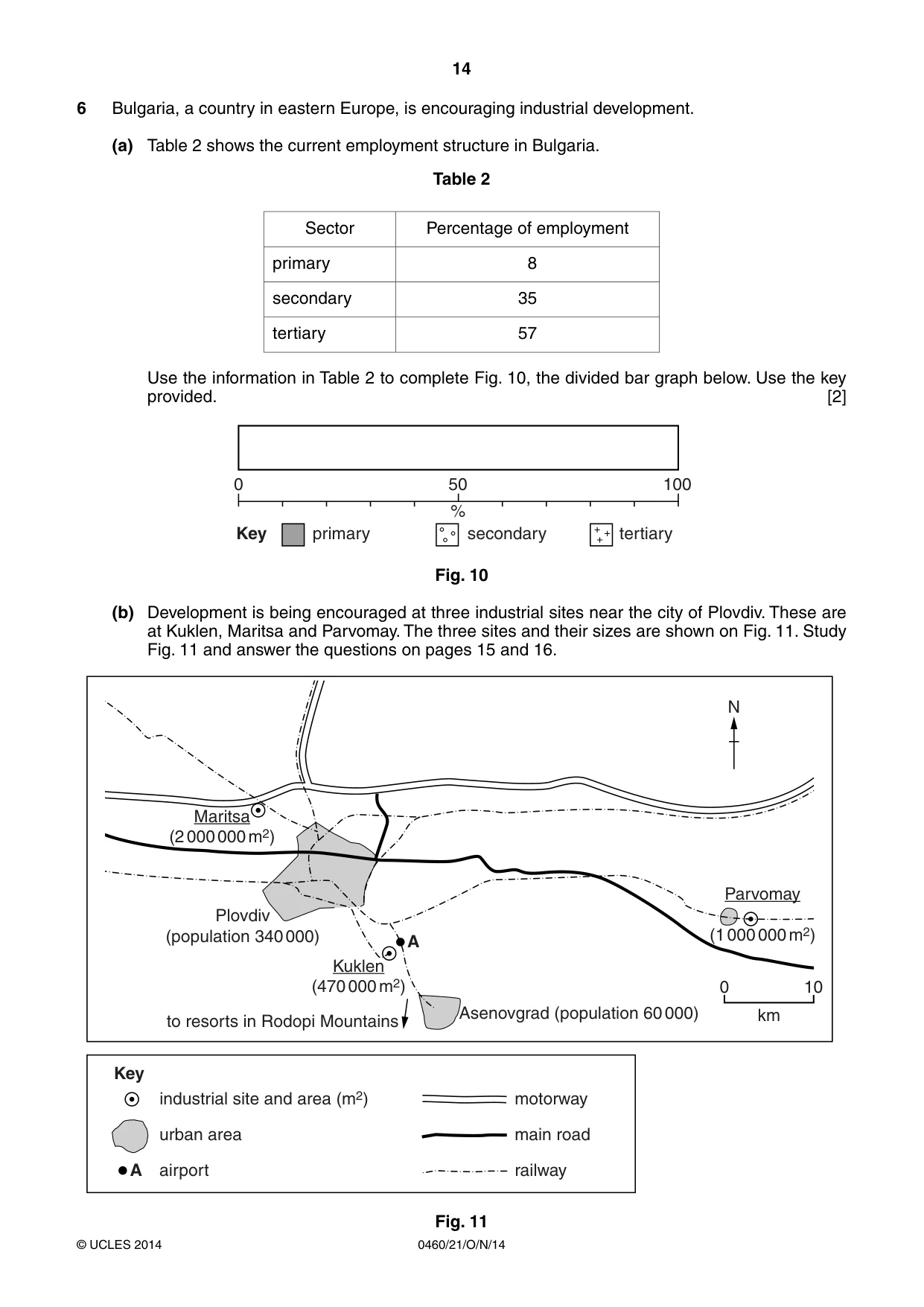
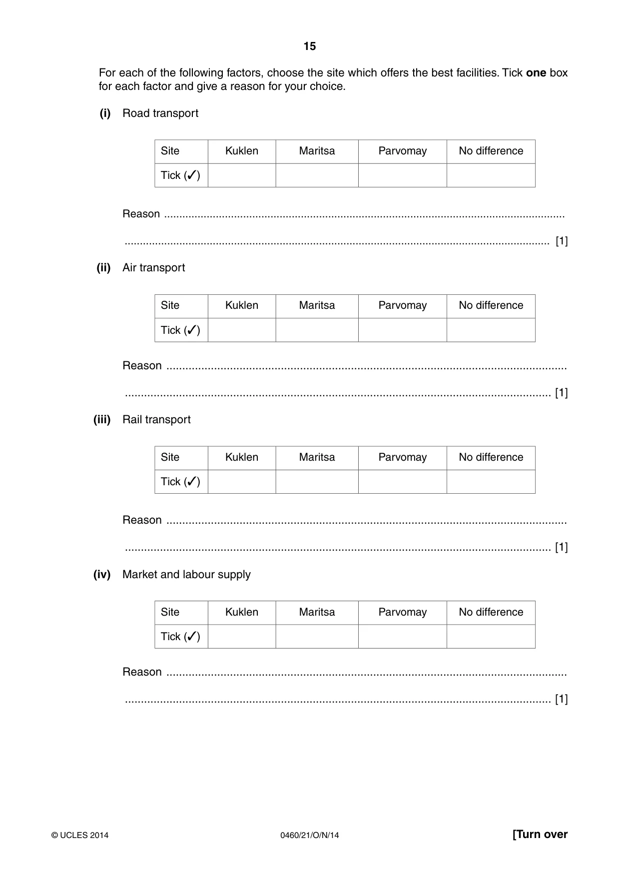
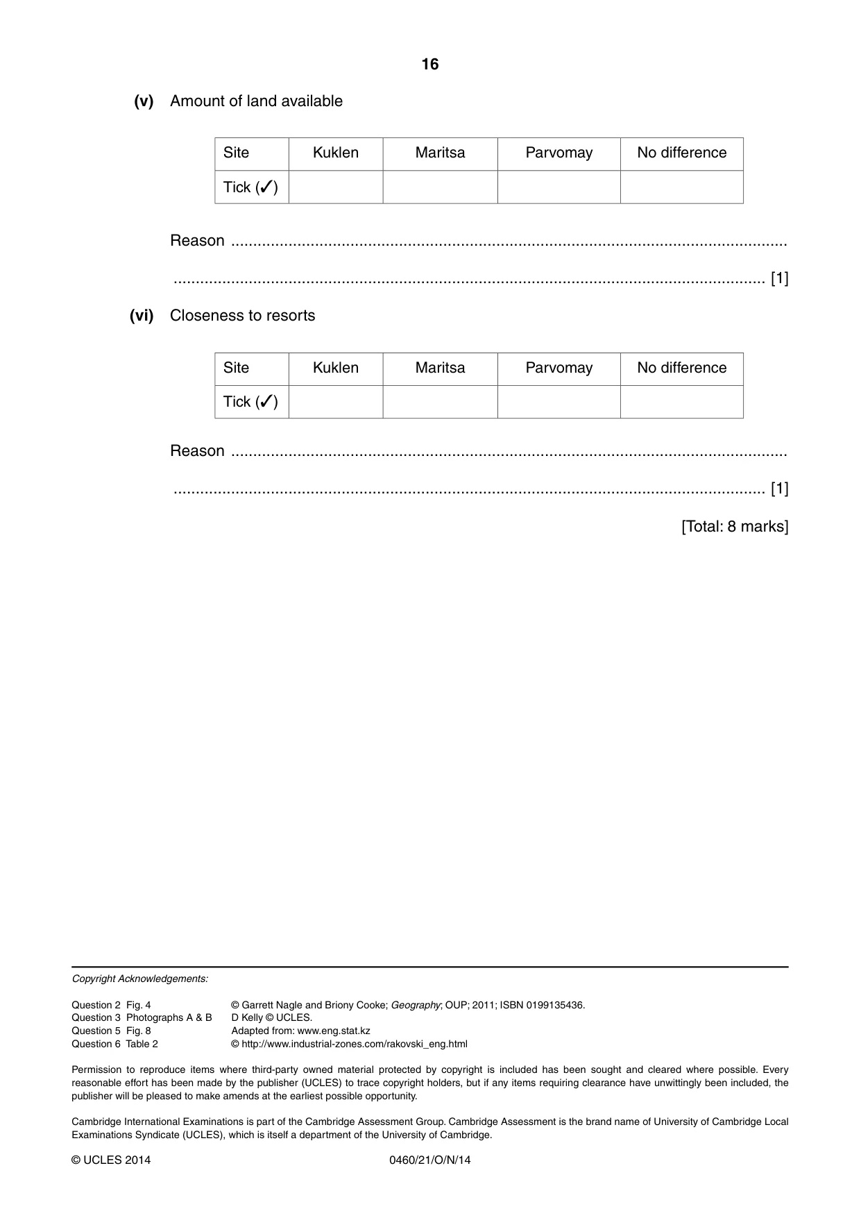
Question paper16 pages

Mark scheme5 pages
Answers below. Sit the paper first if you are practising.
Paper as text
Question paper, page 1
GEOGRAPHY 0460/21 Paper 2 October/November 2014 1 hour 30 minutes Candidates answer on the Question Paper. Additional Materials: Ruler Protractor Plain paper Calculator 1:50 000 Survey Map Extract is enclosed with this Question Paper. READ THESE INSTRUCTIONS FIRST Write your Centre number, candidate number and name in the spaces provided. Write in dark blue or black pen. You may use an HB pencil for any diagrams or graphs. Do not use staples, paper clips, glue or correction fluid. DO NOT WRITE IN ANY BARCODES. Answer all questions. The Insert contains Photographs A and B for Question 3. The Survey Map Extract and the Insert are not required by the Examiner. Sketch maps and diagrams should be drawn whenever they serve to illustrate an answer. At the end of the examination, fasten all your work securely together. The number of marks is given in brackets [ ] at the end of each question or part question. This document consists of 16 printed pages and 1 Insert. DC (NF/CGW) 80064/5 © UCLES 2014 [Turn over Cambridge International Examinations Cambridge International General Certificate of Secondary Education * 1 6 8 6 9 1 4 3 8 9 *
Question paper, page 2
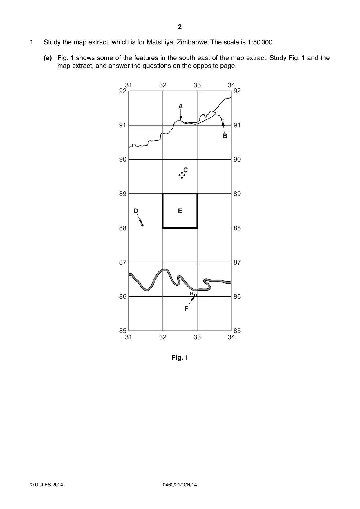
2 0460/21/O/N/14 © UCLES 2014 1 Study the map extract, which is for Matshiya, Zimbabwe. The scale is 1:50 000. (a) Fig. 1 shows some of the features in the south east of the map extract. Study Fig. 1 and the map extract, and answer the questions on the opposite page. 91 92 90 89 88 87 85 86 91 31 32 33 34 31 32 33 F R D E C B A 34 92 90 89 88 87 85 86 Fig. 1
Question paper, page 3
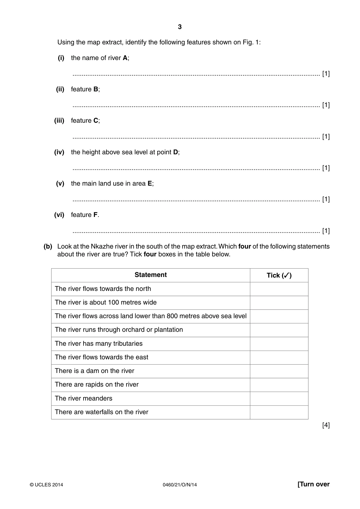
3 0460/21/O/N/14 © UCLES 2014 [Turn over Using the map extract, identify the following features shown on Fig. 1: (i) the name of river A; … [1] (ii) feature B; … [1] (iii) feature C; … [1] (iv) the height above sea level at point D; … [1] (v) the main land use in area E; … [1] (vi) feature F. … [1] (b) Look at the Nkazhe river in the south of the map extract. Which four of the following statements about the river are true? Tick four boxes in the table below. Statement Tick (✓) The river flows towards the north The river is about 100 metres wide The river flows across land lower than 800 metres above sea level The river runs through orchard or plantation The river has many tributaries The river flows towards the east There is a dam on the river There are rapids on the river The river meanders There are waterfalls on the river [4]
Question paper, page 4
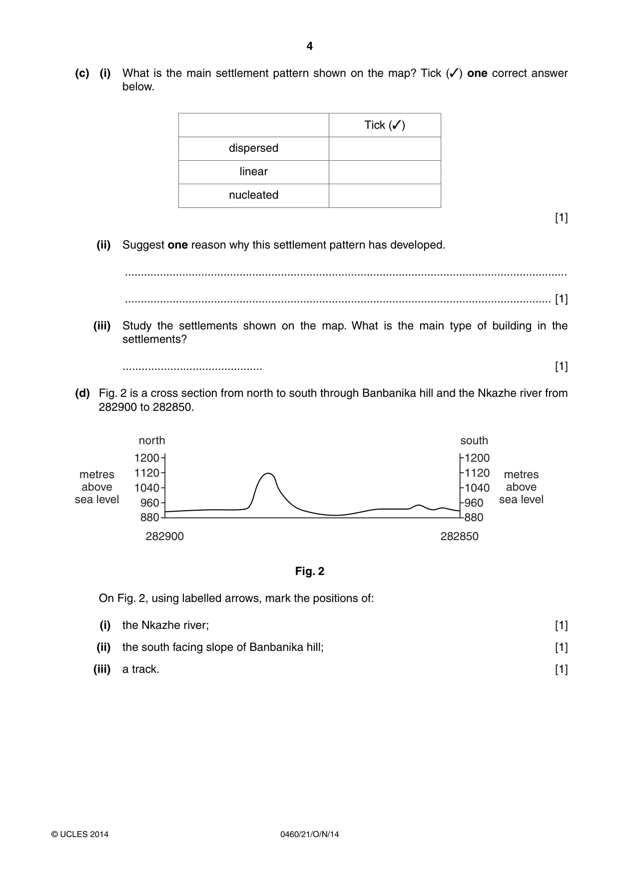
4 0460/21/O/N/14 © UCLES 2014 (c) (i) What is the main settlement pattern shown on the map? Tick (✓) one correct answer below. Tick (✓) dispersed linear nucleated [1] (ii) Suggest one reason why this settlement pattern has developed. … … [1] (iii) Study the settlements shown on the map. What is the main type of building in the settlements? … [1] (d) Fig. 2 is a cross section from north to south through Banbanika hill and the Nkazhe river from 282900 to 282850. 1200 1120 1040 960 880 282850 282900 1200 north south 1120 1040 metres above sea level metres above sea level 960 880 Fig. 2 On Fig. 2, using labelled arrows, mark the positions of: (i) the Nkazhe river; [1] (ii) the south facing slope of Banbanika hill; [1] (iii) a track. [1]
Question paper, page 5
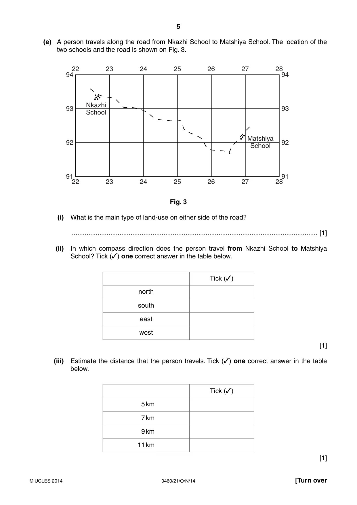
5 0460/21/O/N/14 © UCLES 2014 [Turn over (e) A person travels along the road from Nkazhi School to Matshiya School. The location of the two schools and the road is shown on Fig. 3. 94 93 91 92 94 93 91 92 Matshiya School Nkazhi School 22 23 24 25 26 27 28 22 23 24 25 26 27 28 Fig. 3 (i) What is the main type of land-use on either side of the road? … [1] (ii) In which compass direction does the person travel from Nkazhi School to Matshiya School? Tick (✓) one correct answer in the table below. Tick (✓) north south east west [1] (iii) Estimate the distance that the person travels. Tick (✓) one correct answer in the table below. Tick (✓) 5 km 7 km 9 km 11 km [1]
Question paper, page 6
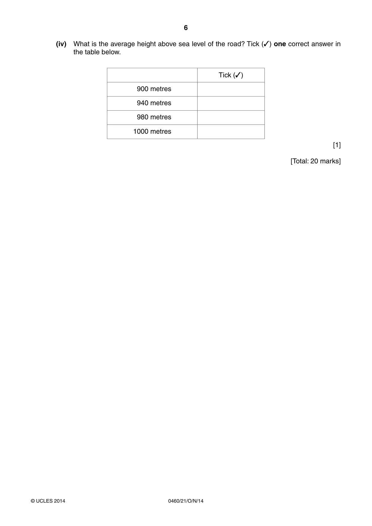
6 0460/21/O/N/14 © UCLES 2014 (iv) What is the average height above sea level of the road? Tick (✓) one correct answer in the table below. Tick (✓) 900 metres 940 metres 980 metres 1000 metres [1] [Total: 20 marks]
Question paper, page 7
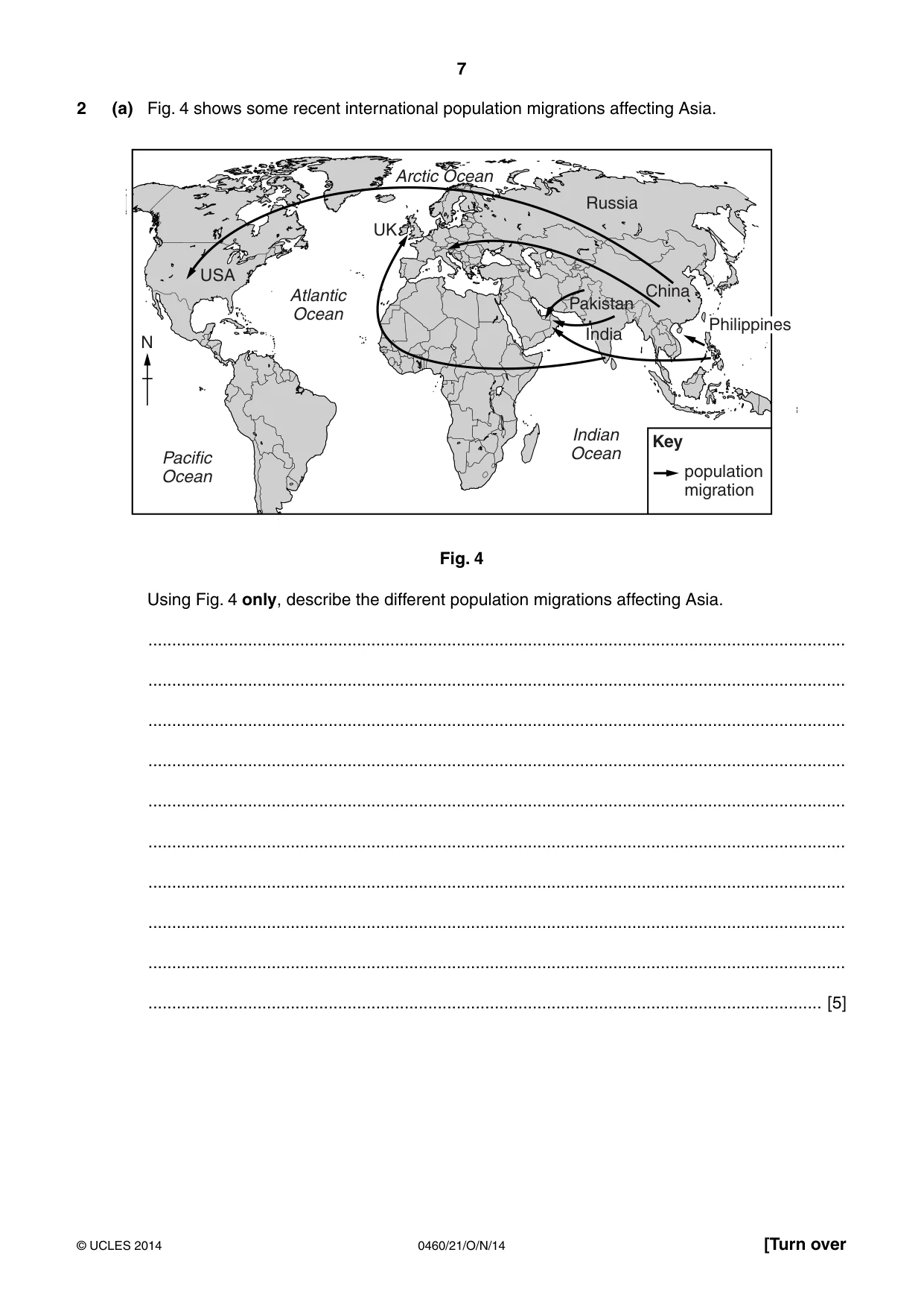
7 0460/21/O/N/14 © UCLES 2014 [Turn over 2 (a) Fig. 4 shows some recent international population migrations affecting Asia. N Pacific Ocean Atlantic Ocean Indian Ocean Arctic Ocean Philippines population migration China UK USA Russia India Pakistan Key Fig. 4 Using Fig. 4 only, describe the different population migrations affecting Asia. … … … … … … … … … … [5]
Question paper, page 8
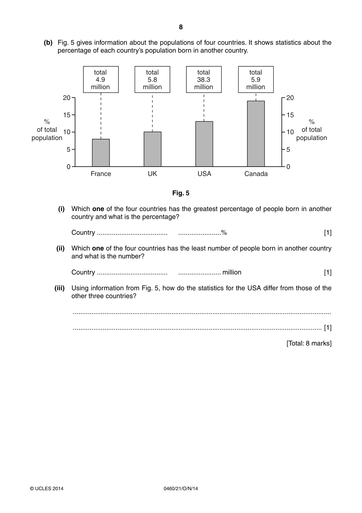
8 0460/21/O/N/14 © UCLES 2014 (b) Fig. 5 gives information about the populations of four countries. It shows statistics about the percentage of each country’s population born in another country. 20 15 % of total population % of total population total 5.8 million total 4.9 million total 5.9 million total 38.3 million 10 0 5 20 France UK USA Canada 15 10 0 5 Fig. 5 (i) Which one of the four countries has the greatest percentage of people born in another country and what is the percentage? Country … …% [1] (ii) Which one of the four countries has the least number of people born in another country and what is the number? Country … … million [1] (iii) Using information from Fig. 5, how do the statistics for the USA differ from those of the other three countries? … … [1] [Total: 8 marks]
Question paper, page 9
9 0460/21/O/N/14 © UCLES 2014 [Turn over 3 Photographs A and B (Insert) show two river valleys. (a) Identify features X, Y and Z on Photograph A. Choose your answers from the list below: flood plain, V-shaped valley, meanders, plateau, levees, interlocking spurs. X … Y … Z … [3] (b) Describe the river and the relief of the valley in Photograph B. … … … … … … … … … … … … [5] [Total: 8 marks]
Question paper, page 10
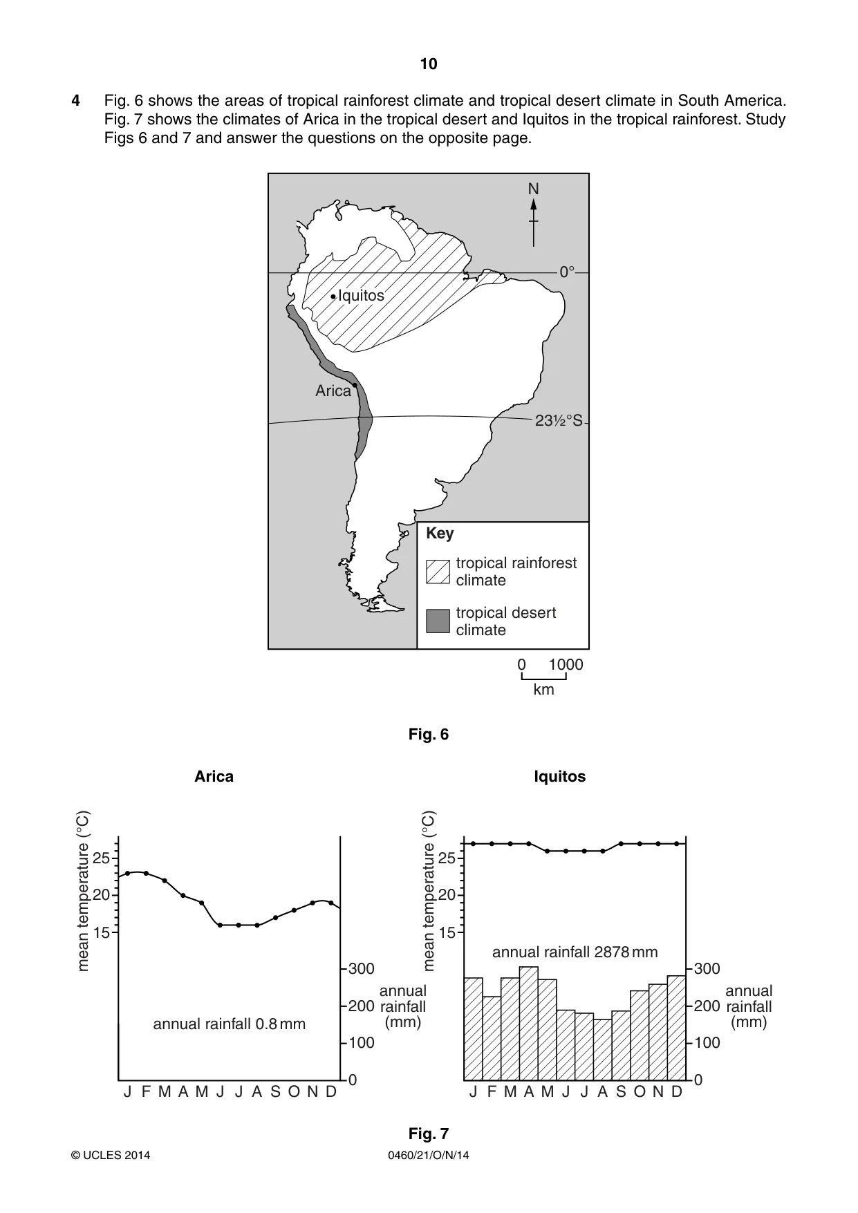
10 0460/21/O/N/14 © UCLES 2014 4 Fig. 6 shows the areas of tropical rainforest climate and tropical desert climate in South America. Fig. 7 shows the climates of Arica in the tropical desert and Iquitos in the tropical rainforest. Study Figs 6 and 7 and answer the questions on the opposite page. Iquitos Arica Key km 0 1000 tropical rainforest climate tropical desert climate 0° N 23½°S Fig. 6 Arica Iquitos J F M A M J J A S O N D 0 100 200 300 annual rainfall (mm) annual rainfall 0.8 mm 25 20 mean temperature (°C) 15 J F M A M J J A S O N D 0 100 200 300 annual rainfall (mm) annual rainfall 2878 mm 25 20 mean temperature (°C) 15 Fig. 7
Question paper, page 11
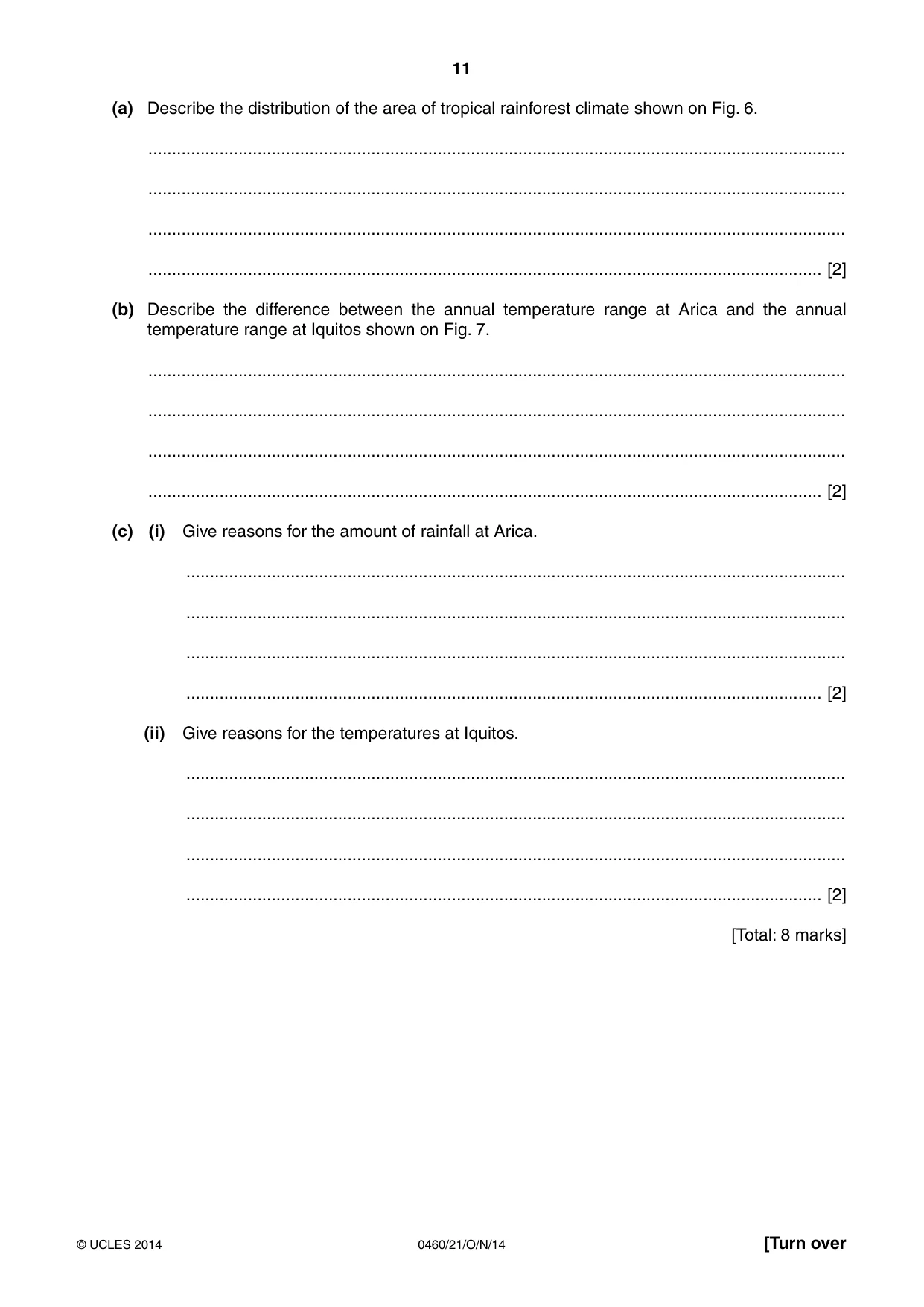
11 0460/21/O/N/14 © UCLES 2014 [Turn over (a) Describe the distribution of the area of tropical rainforest climate shown on Fig. 6. … … … … [2] (b) Describe the difference between the annual temperature range at Arica and the annual temperature range at Iquitos shown on Fig. 7. … … … … [2] (c) (i) Give reasons for the amount of rainfall at Arica. … … … … [2] (ii) Give reasons for the temperatures at Iquitos. … … … … [2] [Total: 8 marks]
Question paper, page 12
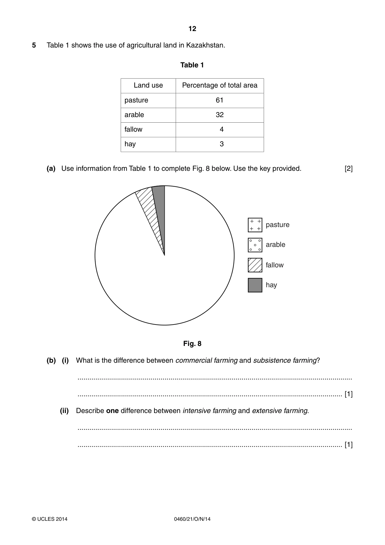
12 0460/21/O/N/14 © UCLES 2014 5 Table 1 shows the use of agricultural land in Kazakhstan. Table 1 Land use Percentage of total area pasture 61 arable 32 fallow 4 hay 3 (a) Use information from Table 1 to complete Fig. 8 below. Use the key provided. [2] pasture arable fallow hay Fig. 8 (b) (i) What is the difference between commercial farming and subsistence farming? … … [1] (ii) Describe one difference between intensive farming and extensive farming. … … [1]
Question paper, page 13
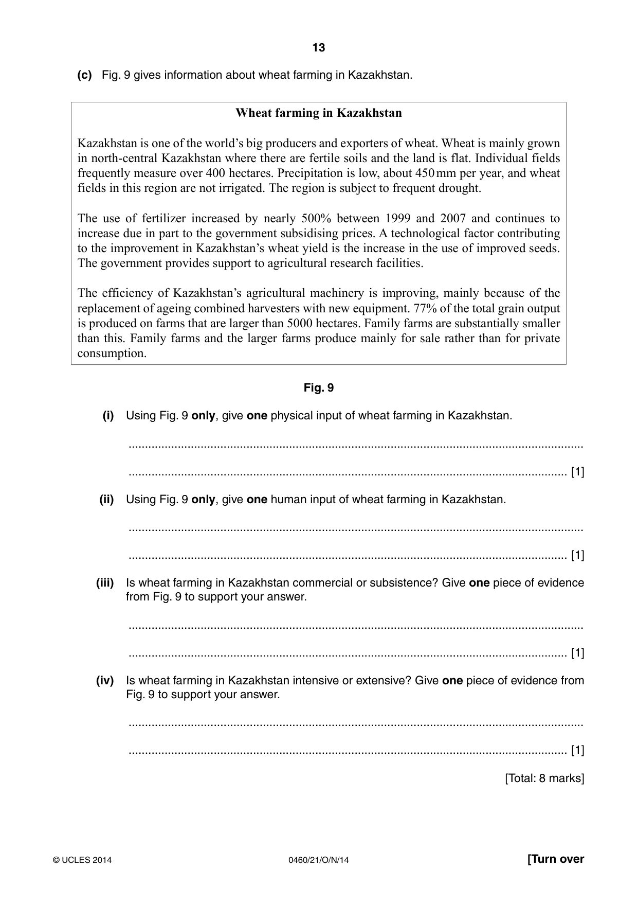
13 0460/21/O/N/14 © UCLES 2014 [Turn over (c) Fig. 9 gives information about wheat farming in Kazakhstan. Wheat farming in Kazakhstan Kazakhstan is one of the world’s big producers and exporters of wheat. Wheat is mainly grown in north-central Kazakhstan where there are fertile soils and the land is flat. Individual fields frequently measure over 400 hectares. Precipitation is low, about 450 mm per year, and wheat fields in this region are not irrigated. The region is subject to frequent drought. The use of fertilizer increased by nearly 500% between 1999 and 2007 and continues to increase due in part to the government subsidising prices. A technological factor contributing to the improvement in Kazakhstan’s wheat yield is the increase in the use of improved seeds. The government provides support to agricultural research facilities. The efficiency of Kazakhstan’s agricultural machinery is improving, mainly because of the replacement of ageing combined harvesters with new equipment. 77% of the total grain output is produced on farms that are larger than 5000 hectares. Family farms are substantially smaller than this. Family farms and the larger farms produce mainly for sale rather than for private consumption. Fig. 9 (i) Using Fig. 9 only, give one physical input of wheat farming in Kazakhstan. … … [1] (ii) Using Fig. 9 only, give one human input of wheat farming in Kazakhstan. … … [1] (iii) Is wheat farming in Kazakhstan commercial or subsistence? Give one piece of evidence from Fig. 9 to support your answer. … … [1] (iv) Is wheat farming in Kazakhstan intensive or extensive? Give one piece of evidence from Fig. 9 to support your answer. … … [1] [Total: 8 marks]
Question paper, page 14
14 0460/21/O/N/14 © UCLES 2014 6 Bulgaria, a country in eastern Europe, is encouraging industrial development. (a) Table 2 shows the current employment structure in Bulgaria. Table 2 Sector Percentage of employment primary 8 secondary 35 tertiary 57 Use the information in Table 2 to complete Fig. 10, the divided bar graph below. Use the key provided. [2] 0 50 % primary Key secondary tertiary 100 Fig. 10 (b) Development is being encouraged at three industrial sites near the city of Plovdiv. These are at Kuklen, Maritsa and Parvomay. The three sites and their sizes are shown on Fig. 11. Study Fig. 11 and answer the questions on pages 15 and 16. km 0 10 N A Maritsa (2 000 000 m2) Kuklen (470 000 m2) Plovdiv (population 340 000) Asenovgrad (population 60 000) to resorts in Rodopi Mountains industrial site and area (m2) Key urban area airport motorway main road railway Parvomay (1 000 000 m2) A Fig. 11
Question paper, page 15
15 0460/21/O/N/14 © UCLES 2014 [Turn over For each of the following factors, choose the site which offers the best facilities. Tick one box for each factor and give a reason for your choice. (i) Road transport Site Kuklen Maritsa Parvomay No difference Tick (✓) Reason … … [1] (ii) Air transport Site Kuklen Maritsa Parvomay No difference Tick (✓) Reason … … [1] (iii) Rail transport Site Kuklen Maritsa Parvomay No difference Tick (✓) Reason … … [1] (iv) Market and labour supply Site Kuklen Maritsa Parvomay No difference Tick (✓) Reason … … [1]
Question paper, page 16
16 0460/21/O/N/14 © UCLES 2014 (v) Amount of land available Site Kuklen Maritsa Parvomay No difference Tick (✓) Reason … … [1] (vi) Closeness to resorts Site Kuklen Maritsa Parvomay No difference Tick (✓) Reason … … [1] [Total: 8 marks] Copyright Acknowledgements: Question 2 Fig. 4 © Garrett Nagle and Briony Cooke; Geography; OUP; 2011; ISBN 0199135436. Question 3 Photographs A & B D Kelly © UCLES. Question 5 Fig. 8 Adapted from: www.eng.stat.kz Question 6 Table 2 © http://www.industrial-zones.com/rakovski_eng.html Permission to reproduce items where third-party owned material protected by copyright is included has been sought and cleared where possible. Every reasonable effort has been made by the publisher (UCLES) to trace copyright holders, but if any items requiring clearance have unwittingly been included, the publisher will be pleased to make amends at the earliest possible opportunity. Cambridge International Examinations is part of the Cambridge Assessment Group. Cambridge Assessment is the brand name of University of Cambridge Local Examinations Syndicate (UCLES), which is itself a department of the University of Cambridge.
Mark scheme, page 1
® IGCSE is the registered trademark of Cambridge International Examinations. CAMBRIDGE INTERNATIONAL EXAMINATIONS Cambridge International General Certificate of Secondary Education MARK SCHEME for the October/November 2014 series 0460 GEOGRAPHY 0460/21 Paper 2, maximum raw mark 60 This mark scheme is published as an aid to teachers and candidates, to indicate the requirements of the examination. It shows the basis on which Examiners were instructed to award marks. It does not indicate the details of the discussions that took place at an Examiners’ meeting before marking began, which would have considered the acceptability of alternative answers. Mark schemes should be read in conjunction with the question paper and the Principal Examiner Report for Teachers. Cambridge will not enter into discussions about these mark schemes. Cambridge is publishing the mark schemes for the October/November 2014 series for most Cambridge IGCSE®, Cambridge International A and AS Level components and some Cambridge O Level components.
Mark scheme, page 2
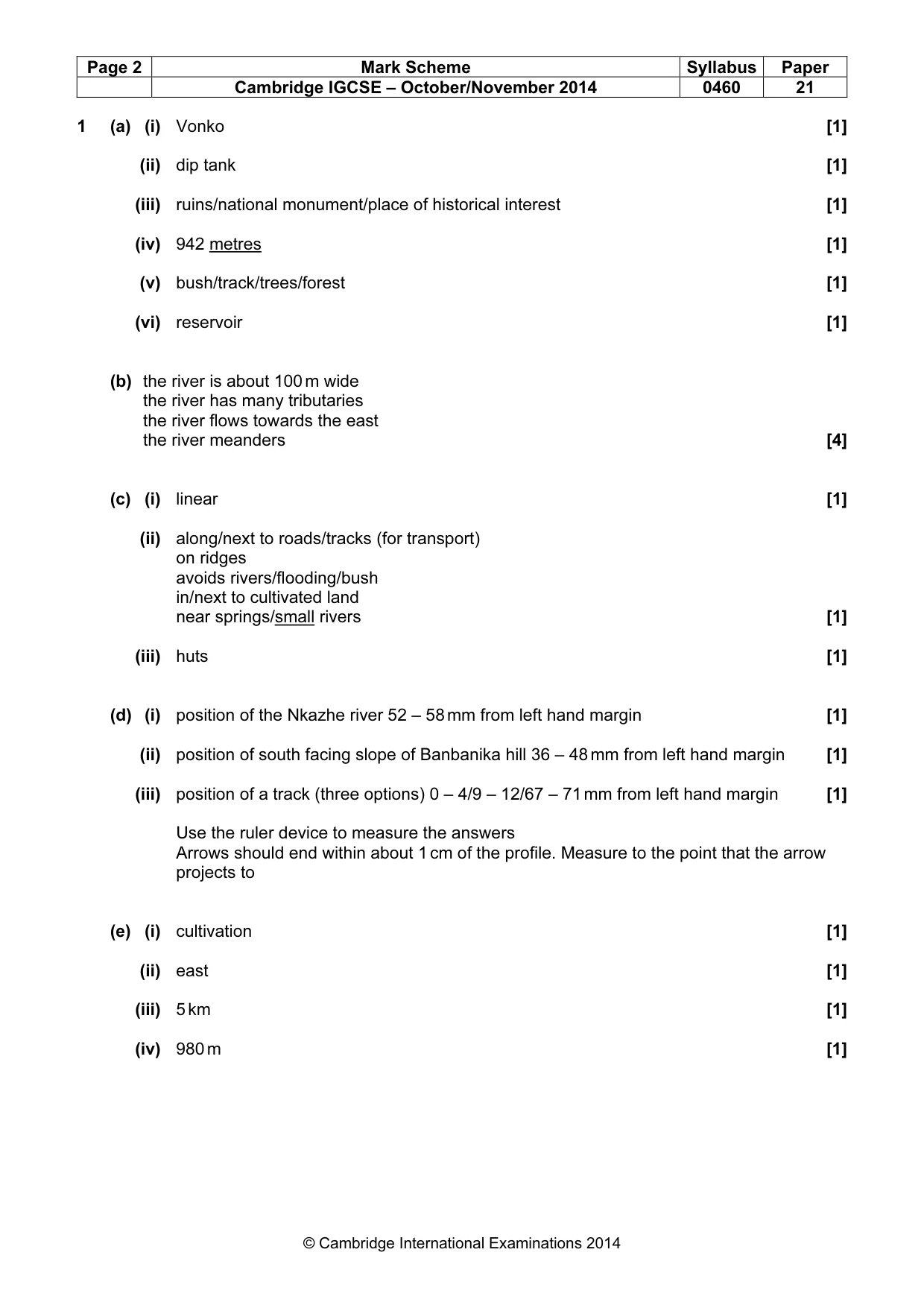
Page 2 Mark Scheme Syllabus Paper Cambridge IGCSE – October/November 2014 0460 21 © Cambridge International Examinations 2014 1 (a) (i) Vonko [1] (ii) dip tank [1] (iii) ruins/national monument/place of historical interest [1] (iv) 942 metres [1] (v) bush/track/trees/forest [1] (vi) reservoir [1] (b) the river is about 100 m wide the river has many tributaries the river flows towards the east the river meanders [4] (c) (i) linear [1] (ii) along/next to roads/tracks (for transport) on ridges avoids rivers/flooding/bush in/next to cultivated land near springs/small rivers [1] (iii) huts [1] (d) (i) position of the Nkazhe river 52 – 58 mm from left hand margin [1] (ii) position of south facing slope of Banbanika hill 36 – 48 mm from left hand margin [1] (iii) position of a track (three options) 0 – 4/9 – 12/67 – 71 mm from left hand margin [1] Use the ruler device to measure the answers Arrows should end within about 1 cm of the profile. Measure to the point that the arrow projects to (e) (i) cultivation [1] (ii) east [1] (iii) 5 km [1] (iv) 980 m [1]
Mark scheme, page 3
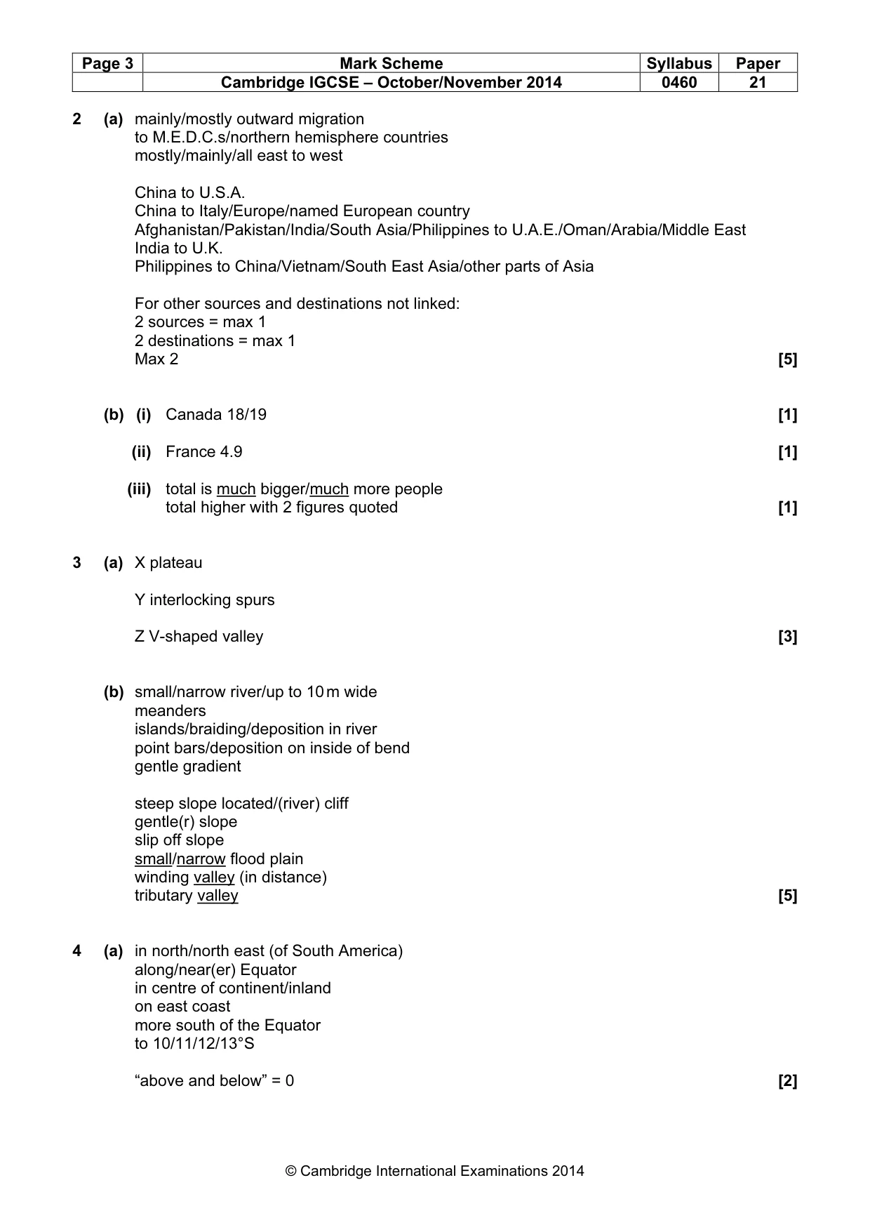
Page 3 Mark Scheme Syllabus Paper Cambridge IGCSE – October/November 2014 0460 21 © Cambridge International Examinations 2014 2 (a) mainly/mostly outward migration to M.E.D.C.s/northern hemisphere countries mostly/mainly/all east to west China to U.S.A. China to Italy/Europe/named European country Afghanistan/Pakistan/India/South Asia/Philippines to U.A.E./Oman/Arabia/Middle East India to U.K. Philippines to China/Vietnam/South East Asia/other parts of Asia For other sources and destinations not linked: 2 sources = max 1 2 destinations = max 1 Max 2 [5] (b) (i) Canada 18/19 [1] (ii) France 4.9 [1] (iii) total is much bigger/much more people total higher with 2 figures quoted [1] 3 (a) X plateau Y interlocking spurs Z V-shaped valley [3] (b) small/narrow river/up to 10 m wide meanders islands/braiding/deposition in river point bars/deposition on inside of bend gentle gradient steep slope located/(river) cliff gentle(r) slope slip off slope small/narrow flood plain winding valley (in distance) tributary valley [5] 4 (a) in north/north east (of South America) along/near(er) Equator in centre of continent/inland on east coast more south of the Equator to 10/11/12/13°S “above and below” = 0 [2]
Mark scheme, page 4
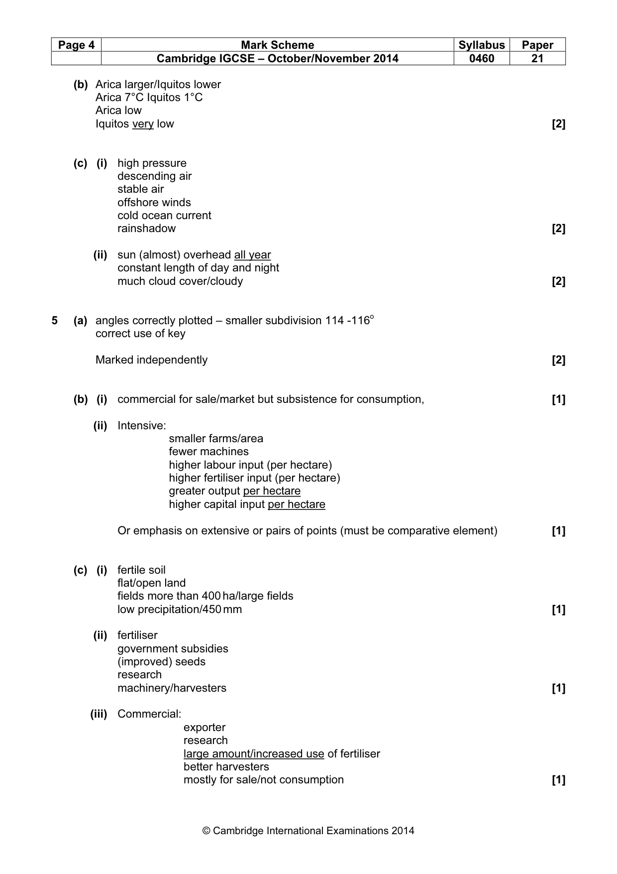
Page 4 Mark Scheme Syllabus Paper Cambridge IGCSE – October/November 2014 0460 21 © Cambridge International Examinations 2014 (b) Arica larger/Iquitos lower Arica 7°C Iquitos 1°C Arica low Iquitos very low [2] (c) (i) high pressure descending air stable air offshore winds cold ocean current rainshadow [2] (ii) sun (almost) overhead all year constant length of day and night much cloud cover/cloudy [2] 5 (a) angles correctly plotted – smaller subdivision 114 -116o correct use of key Marked independently [2] (b) (i) commercial for sale/market but subsistence for consumption, [1] (ii) Intensive: smaller farms/area fewer machines higher labour input (per hectare) higher fertiliser input (per hectare) greater output per hectare higher capital input per hectare Or emphasis on extensive or pairs of points (must be comparative element) [1] (c) (i) fertile soil flat/open land fields more than 400 ha/large fields low precipitation/450 mm [1] (ii) fertiliser government subsidies (improved) seeds research machinery/harvesters [1] (iii) Commercial: exporter research large amount/increased use of fertiliser better harvesters mostly for sale/not consumption [1]
Mark scheme, page 5
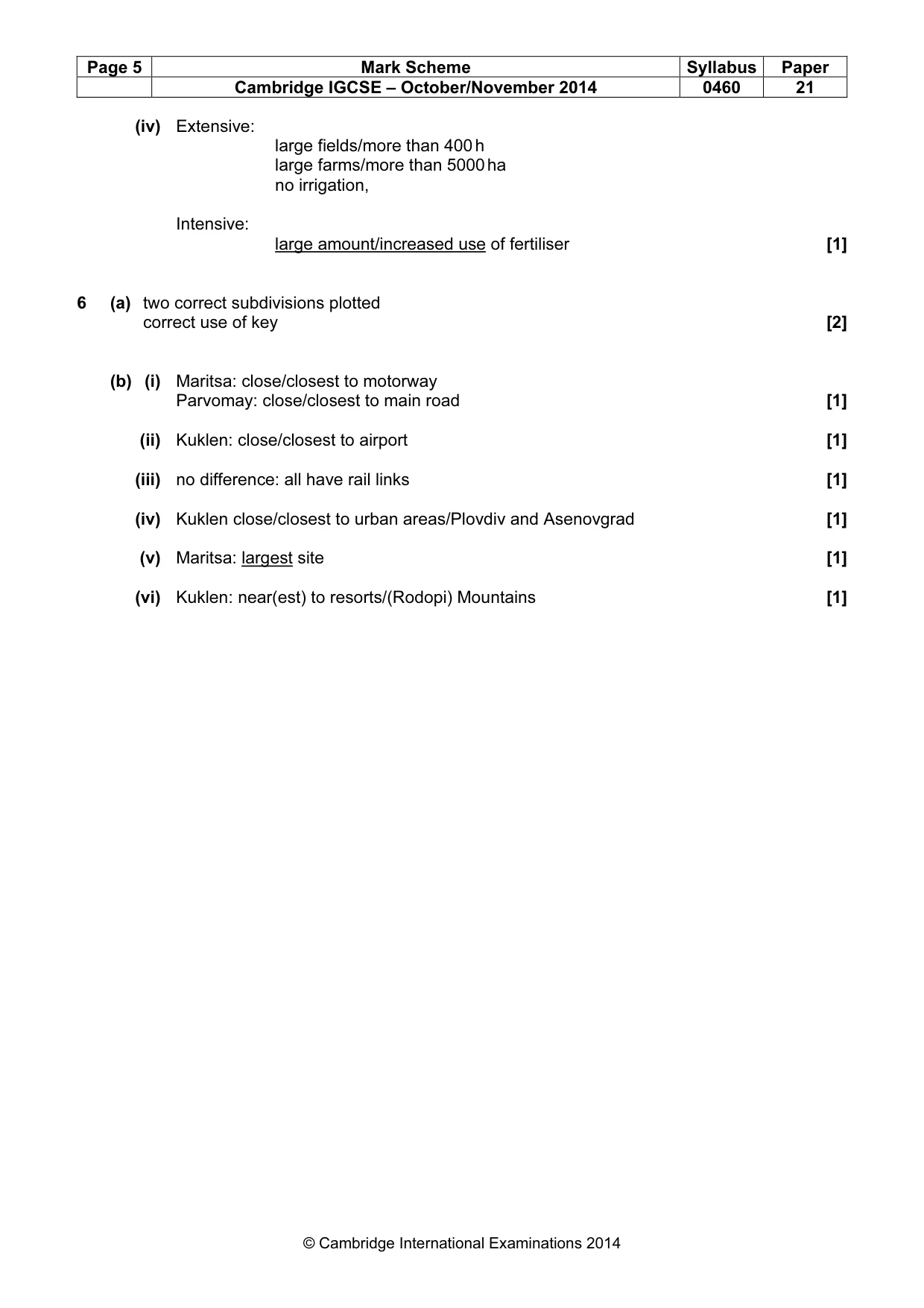
Page 5 Mark Scheme Syllabus Paper Cambridge IGCSE – October/November 2014 0460 21 © Cambridge International Examinations 2014 (iv) Extensive: large fields/more than 400 h large farms/more than 5000 ha no irrigation, Intensive: large amount/increased use of fertiliser [1] 6 (a) two correct subdivisions plotted correct use of key [2] (b) (i) Maritsa: close/closest to motorway Parvomay: close/closest to main road [1] (ii) Kuklen: close/closest to airport [1] (iii) no difference: all have rail links [1] (iv) Kuklen close/closest to urban areas/Plovdiv and Asenovgrad [1] (v) Maritsa: largest site [1] (vi) Kuklen: near(est) to resorts/(Rodopi) Mountains [1]
What you needed in this session
Cambridge’s own grade thresholds for 2014 Oct/Nov, Paper 2 · Variant 1. A higher threshold means an easier paper — the bar moves with how the cohort did.