Cambridge IGCSE Geography 0460 — 2012 May/June Paper 2 · Variant 3
0460/23/M/J/12 · 60 marks · ≈68 min
The question paper and its mark scheme, free to read here and free to download. This is Cambridge’s own paper, exactly as it was sat.
Question paper16 pages
Mark scheme5 pages
Answers below. Sit the paper first if you are practising.
Paper as text
Question paper, page 1
This document consists of 15 printed pages, 1 blank page and 1 Insert. DC (LEO/JG) 46757/5 © UCLES 2012 [Turn over UNIVERSITY OF CAMBRIDGE INTERNATIONAL EXAMINATIONS International General Certificate of Secondary Education * 7 0 9 4 1 8 3 7 2 5 * GEOGRAPHY 0460/23 Paper 2 May/June 2012 1 hour 30 minutes Candidates answer on the Question Paper. Additional Materials: Ruler Plain paper Protractor Calculator 1:25 000 Survey Map Extract is enclosed with this question paper. READ THESE INSTRUCTIONS FIRST Write your Centre number, candidate number and name in the spaces provided. Write in dark blue or black pen. You may use a soft pencil for any diagrams, graphs or rough working. Do not use staples, paper clips, highlighters, glue or correction fluid. DO NOT WRITE ON ANY BARCODES. Answer all questions. The Insert contains Fig. 4 for Question 2 and Photograph A for Question 3. The Survey Map Extract and the Insert are not required by the Examiner. Sketch maps and diagrams should be drawn whenever they serve to illustrate an answer. At the end of the examination, fasten all your work securely together. The number of marks is given in brackets [ ] at the end of each question or part question. For Examiner’s Use Q1 Q2 Q3 Q4 Q5 Q6 Total www.theallpapers.com
Question paper, page 2
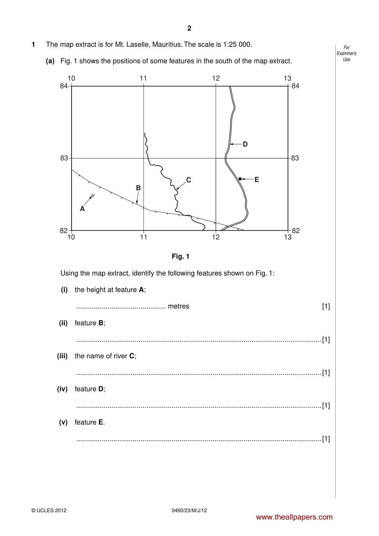
2 © UCLES 2012 0460/23/M/J/12 For Examiner’s Use 1 The map extract is for Mt. Laselle, Mauritius. The scale is 1:25 000. (a) Fig. 1 shows the positions of some features in the south of the map extract. 82 82 83 83 84 84 10 12 11 13 10 12 11 13 D E A B C Fig. 1 Using the map extract, identify the following features shown on Fig. 1: (i) the height at feature A; … metres [1] (ii) feature B; …[1] (iii) the name of river C; …[1] (iv) feature D; …[1] (v) feature E. …[1] www.theallpapers.com
Question paper, page 3
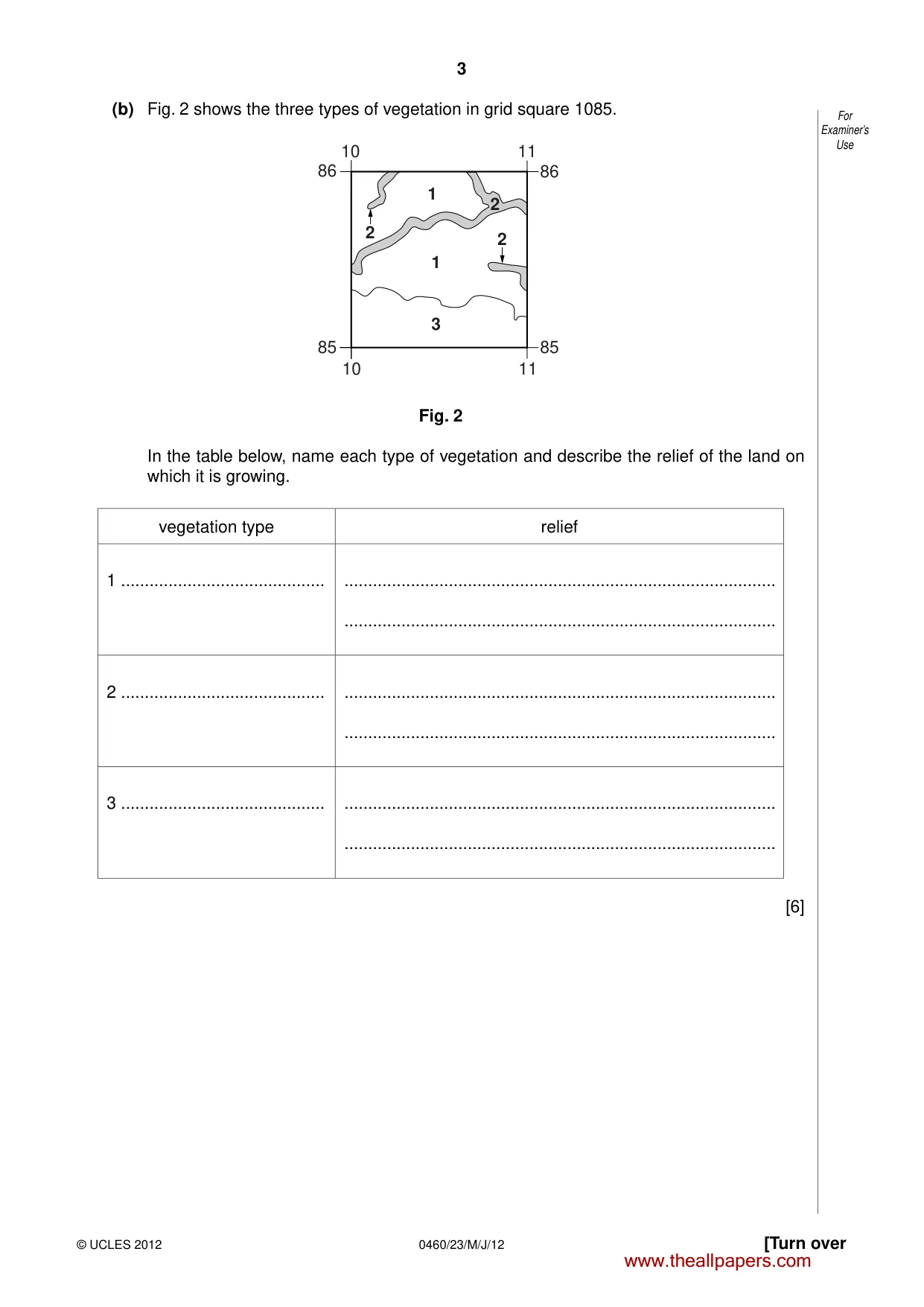
3 © UCLES 2012 [Turn over 0460/23/M/J/12 For Examiner’s Use (b) Fig. 2 shows the three types of vegetation in grid square 1085. 2 2 1 1 3 2 10 11 85 85 86 86 11 10 Fig. 2 In the table below, name each type of vegetation and describe the relief of the land on which it is growing. vegetation type relief 1 … … … 2 … … … 3 … … … [6] www.theallpapers.com
Question paper, page 4
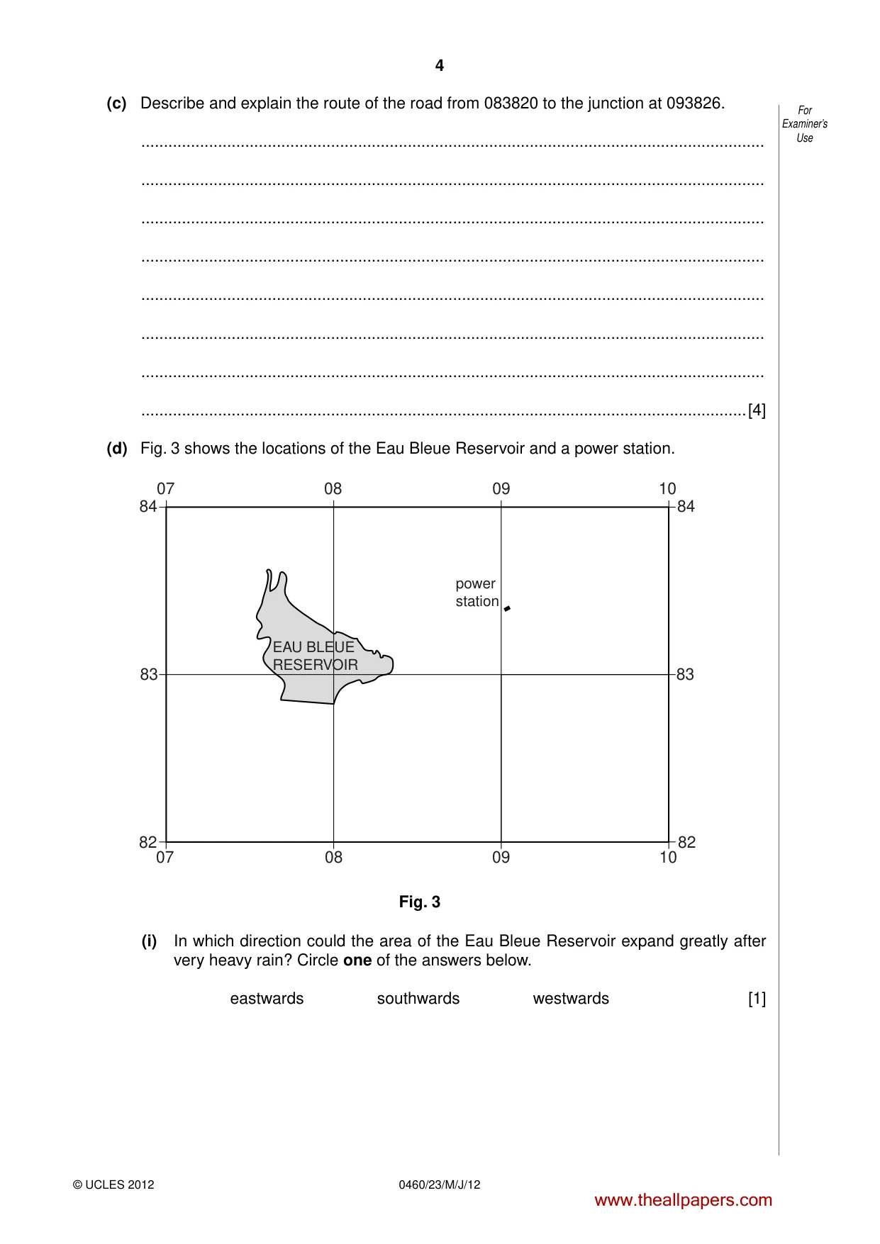
4 © UCLES 2012 0460/23/M/J/12 For Examiner’s Use (c) Describe and explain the route of the road from 083820 to the junction at 093826. … … … … … … … …[4] (d) Fig. 3 shows the locations of the Eau Bleue Reservoir and a power station. 82 82 83 83 84 84 07 09 08 10 07 09 08 10 EAU BLEUE RESERVOIR power station Fig. 3 (i) In which direction could the area of the Eau Bleue Reservoir expand greatly after very heavy rain? Circle one of the answers below. eastwards southwards westwards [1] www.theallpapers.com
Question paper, page 5
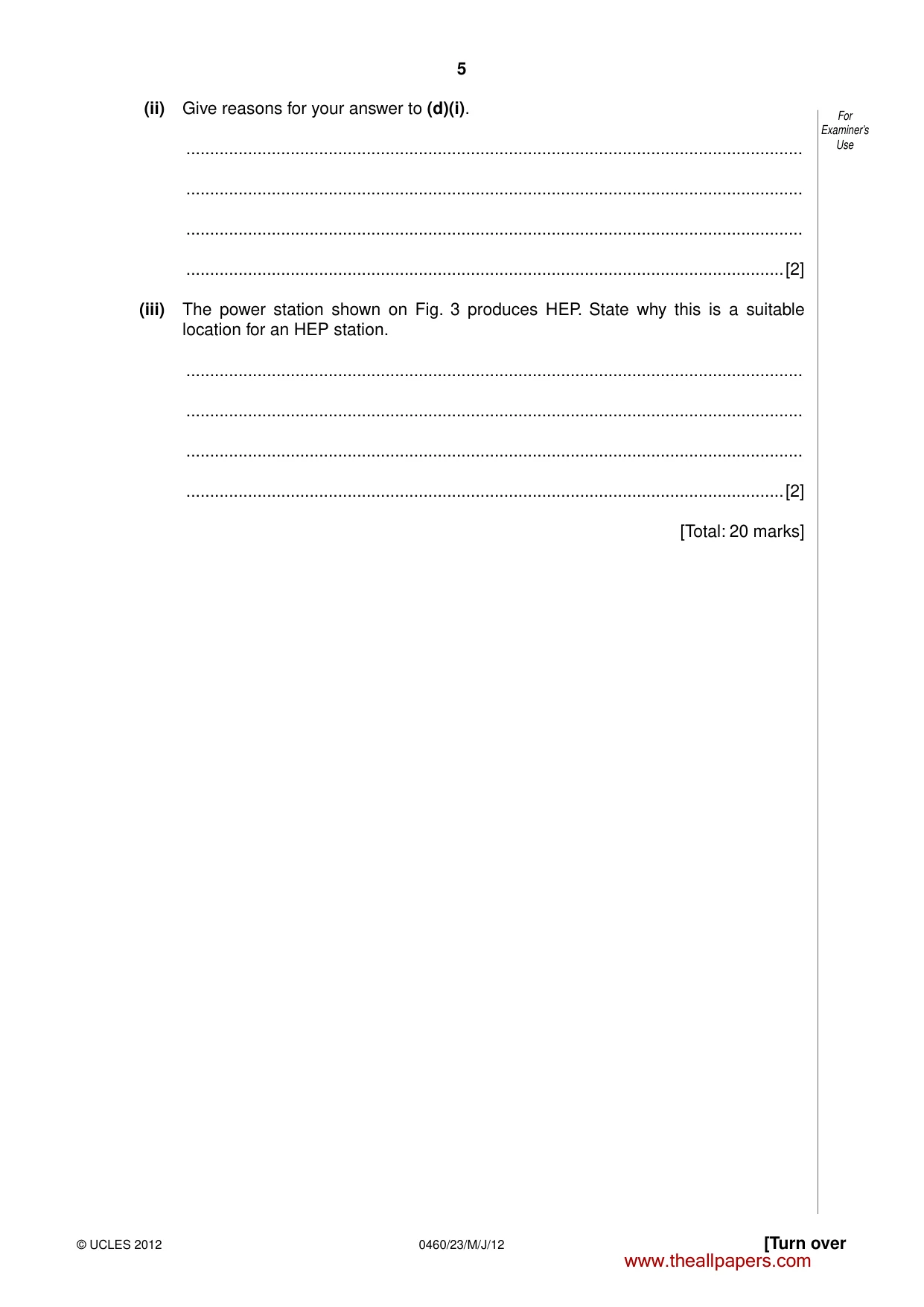
5 © UCLES 2012 [Turn over 0460/23/M/J/12 For Examiner’s Use (ii) Give reasons for your answer to (d)(i). … … … …[2] (iii) The power station shown on Fig. 3 produces HEP. State why this is a suitable location for an HEP station. … … … …[2] [Total: 20 marks] www.theallpapers.com
Question paper, page 6
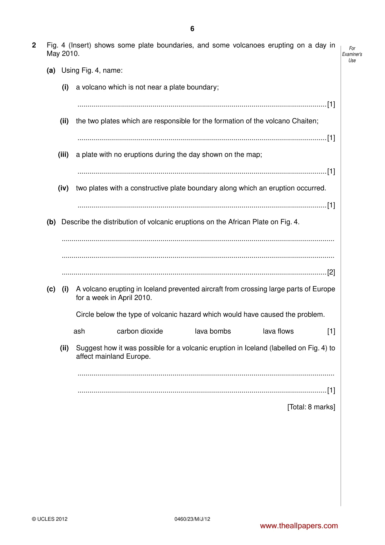
6 © UCLES 2012 0460/23/M/J/12 For Examiner’s Use 2 Fig. 4 (Insert) shows some plate boundaries, and some volcanoes erupting on a day in May 2010. (a) Using Fig. 4, name: (i) a volcano which is not near a plate boundary; …[1] (ii) the two plates which are responsible for the formation of the volcano Chaiten; …[1] (iii) a plate with no eruptions during the day shown on the map; …[1] (iv) two plates with a constructive plate boundary along which an eruption occurred. …[1] (b) Describe the distribution of volcanic eruptions on the African Plate on Fig. 4. … … …[2] (c) (i) A volcano erupting in Iceland prevented aircraft from crossing large parts of Europe for a week in April 2010. Circle below the type of volcanic hazard which would have caused the problem. ash carbon dioxide lava bombs lava flows [1] (ii) Suggest how it was possible for a volcanic eruption in Iceland (labelled on Fig. 4) to affect mainland Europe. … …[1] [Total: 8 marks] www.theallpapers.com
Question paper, page 7
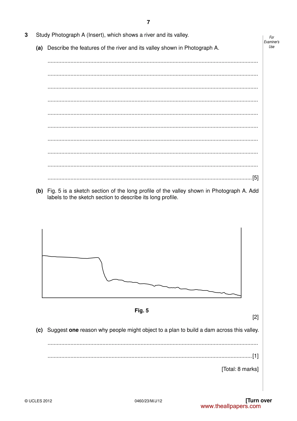
7 © UCLES 2012 [Turn over 0460/23/M/J/12 For Examiner’s Use 3 Study Photograph A (Insert), which shows a river and its valley. (a) Describe the features of the river and its valley shown in Photograph A. … … … … … … … … … …[5] (b) Fig. 5 is a sketch section of the long profile of the valley shown in Photograph A. Add labels to the sketch section to describe its long profile. Fig. 5 [2] (c) Suggest one reason why people might object to a plan to build a dam across this valley. … …[1] [Total: 8 marks] www.theallpapers.com
Question paper, page 8
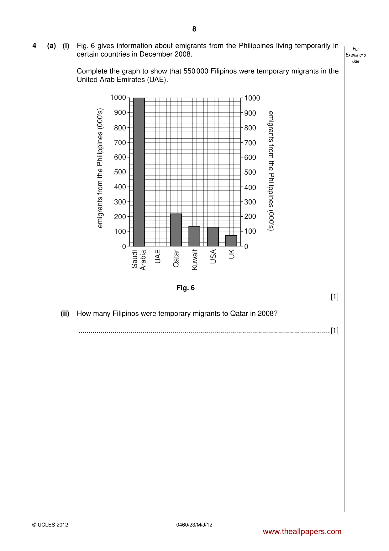
8 © UCLES 2012 0460/23/M/J/12 For Examiner’s Use 4 (a) (i) Fig. 6 gives information about emigrants from the Philippines living temporarily in certain countries in December 2008. Complete the graph to show that 550 000 Filipinos were temporary migrants in the United Arab Emirates (UAE). 0 100 200 300 400 500 600 700 800 900 1000 0 100 200 300 400 500 600 700 800 900 1000 emigrants from the Philippines (000’s) emigrants from the Philippines (000’s) Saudi Arabia Qatar Kuwait USA UAE UK Fig. 6 [1] (ii) How many Filipinos were temporary migrants to Qatar in 2008? …[1] www.theallpapers.com
Question paper, page 9
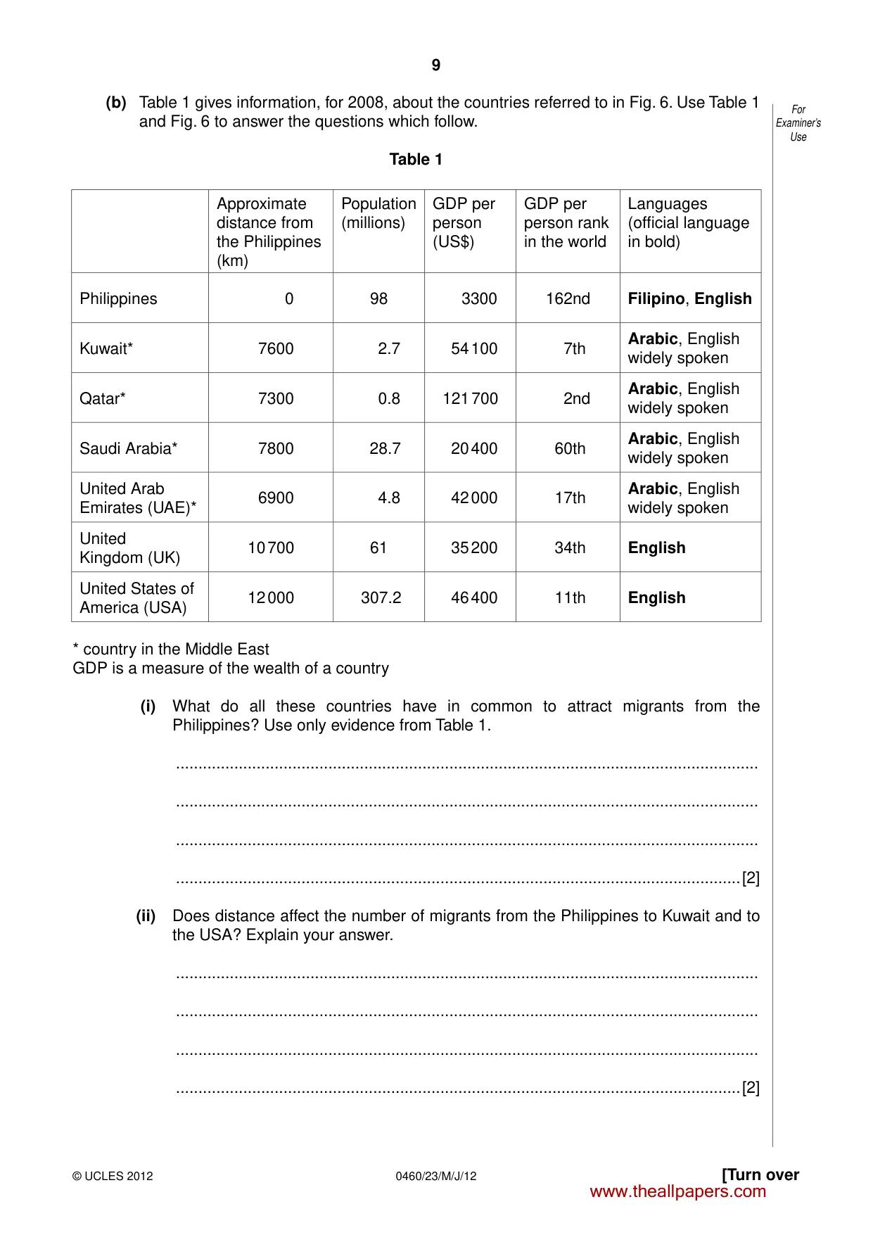
9 © UCLES 2012 [Turn over 0460/23/M/J/12 For Examiner’s Use (b) Table 1 gives information, for 2008, about the countries referred to in Fig. 6. Use Table 1 and Fig. 6 to answer the questions which follow. Table 1 Approximate distance from the Philippines (km) Population (millions) GDP per person (US$) GDP per person rank in the world Languages (official language in bold) Philippines 0 98 3300 162nd Filipino, English Kuwait* 7600 2.7 54 100 7th Arabic, English widely spoken Qatar* 7300 0.8 121 700 2nd Arabic, English widely spoken Saudi Arabia* 7800 28.7 20 400 60th Arabic, English widely spoken United Arab Emirates (UAE)* 6900 4.8 42 000 17th Arabic, English widely spoken United Kingdom (UK) 10 700 61 35 200 34th English United States of America (USA) 12 000 307.2 46 400 11th English * country in the Middle East GDP is a measure of the wealth of a country (i) What do all these countries have in common to attract migrants from the Philippines? Use only evidence from Table 1. … … … …[2] (ii) Does distance affect the number of migrants from the Philippines to Kuwait and to the USA? Explain your answer. … … … …[2] www.theallpapers.com
Question paper, page 10
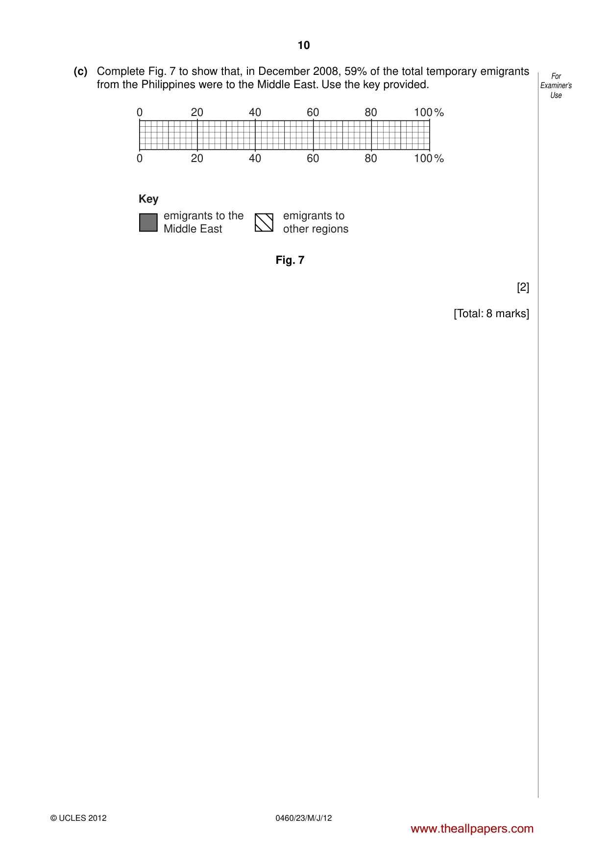
10 © UCLES 2012 0460/23/M/J/12 For Examiner’s Use (c) Complete Fig. 7 to show that, in December 2008, 59% of the total temporary emigrants from the Philippines were to the Middle East. Use the key provided. 0 20 20 emigrants to the Middle East 40 40 60 60 80 80 100 % 100 % 0 emigrants to other regions Key Fig. 7 [2] [Total: 8 marks] www.theallpapers.com
Question paper, page 11
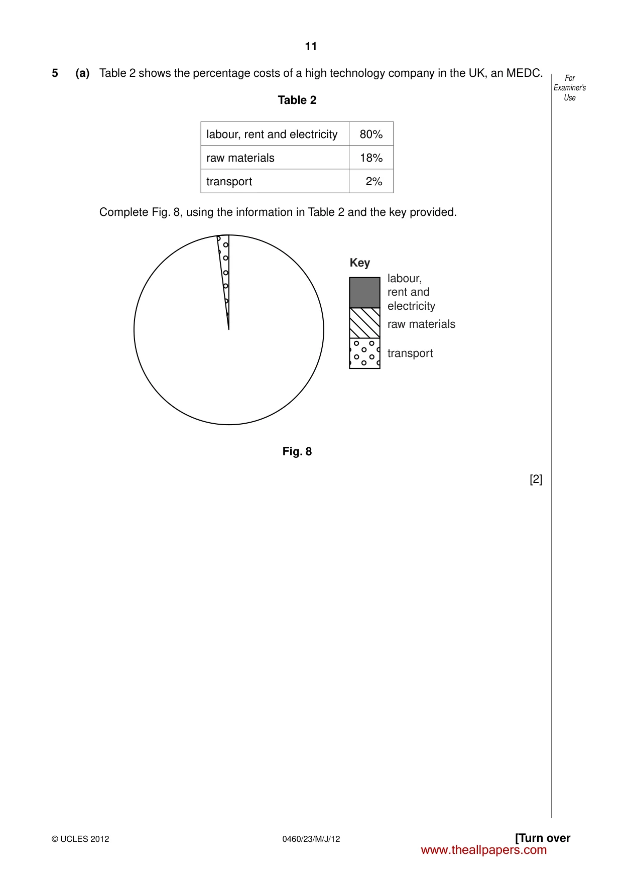
11 © UCLES 2012 [Turn over 0460/23/M/J/12 For Examiner’s Use 5 (a) Table 2 shows the percentage costs of a high technology company in the UK, an MEDC. Table 2 labour, rent and electricity 80% raw materials 18% transport 2% Complete Fig. 8, using the information in Table 2 and the key provided. Key labour, rent and electricity raw materials transport Fig. 8 [2] www.theallpapers.com
Question paper, page 12
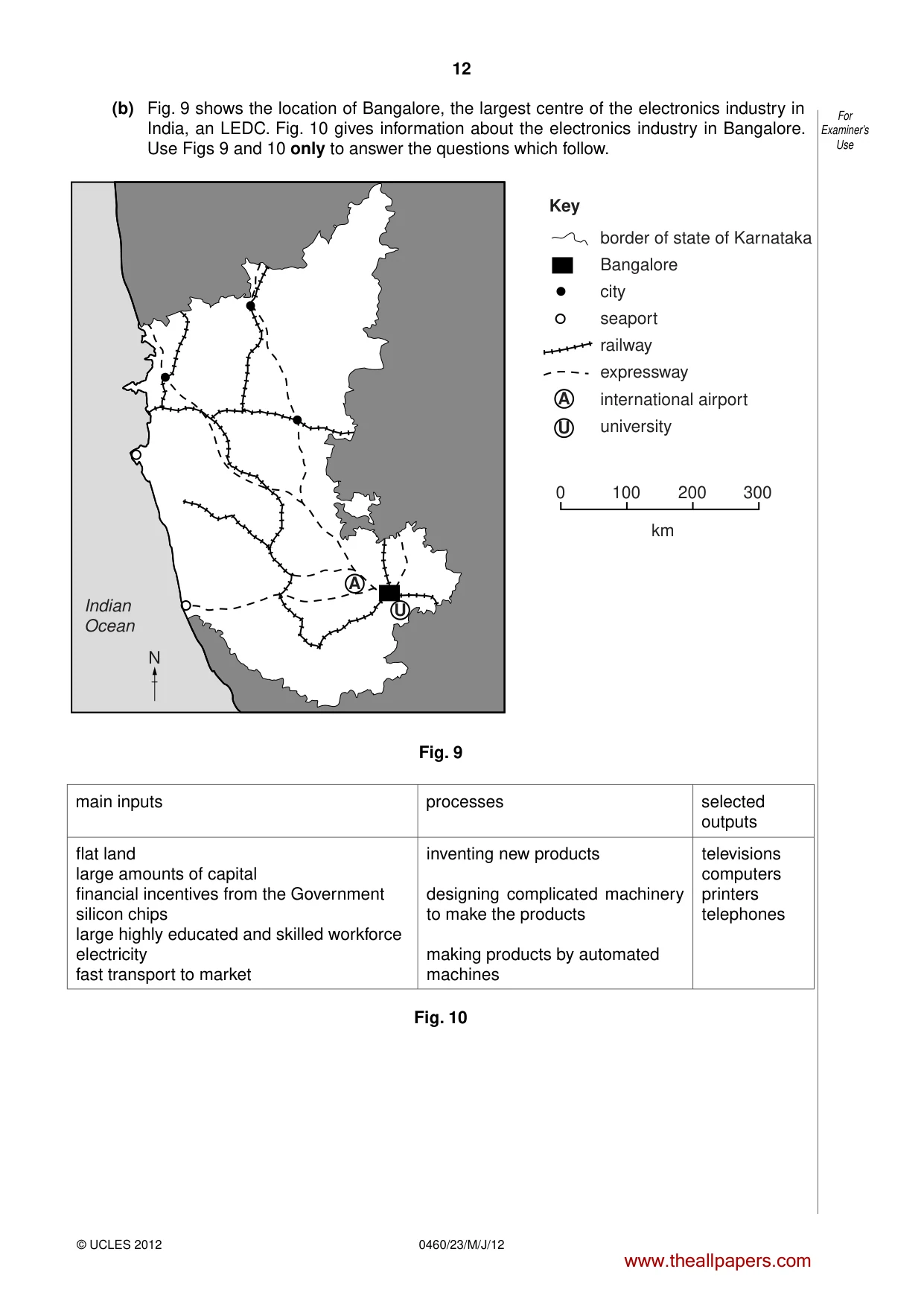
12 © UCLES 2012 0460/23/M/J/12 For Examiner’s Use (b) Fig. 9 shows the location of Bangalore, the largest centre of the electronics industry in India, an LEDC. Fig. 10 gives information about the electronics industry in Bangalore. Use Figs 9 and 10 only to answer the questions which follow. Indian Ocean A A U U Key 0 100 200 300 km border of state of Karnataka Bangalore city seaport railway expressway international airport university N Fig. 9 main inputs processes selected outputs flat land large amounts of capital financial incentives from the Government silicon chips large highly educated and skilled workforce electricity fast transport to market inventing new products designing complicated machinery to make the products making products by automated machines televisions computers printers telephones Fig. 10 www.theallpapers.com
Question paper, page 13
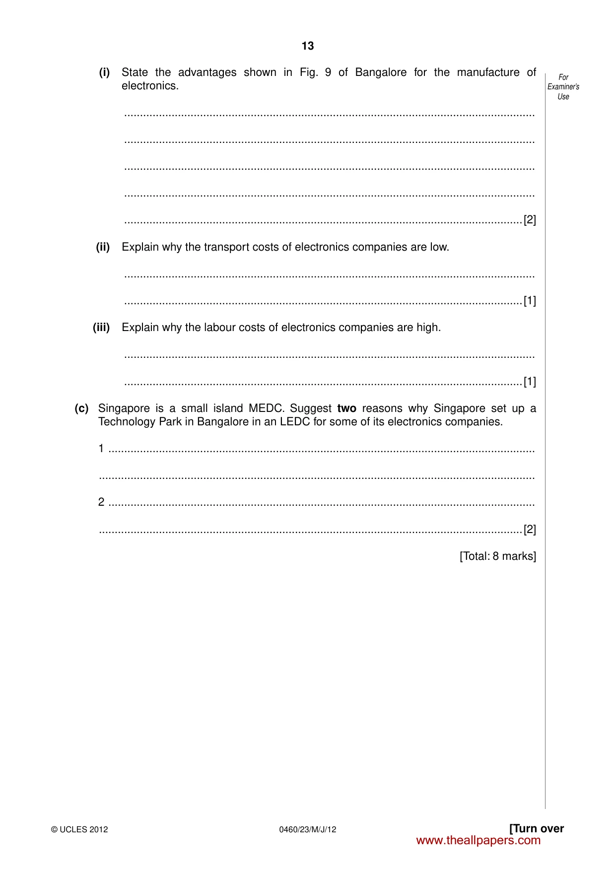
13 © UCLES 2012 [Turn over 0460/23/M/J/12 For Examiner’s Use (i) State the advantages shown in Fig. 9 of Bangalore for the manufacture of electronics. … … … … …[2] (ii) Explain why the transport costs of electronics companies are low. … …[1] (iii) Explain why the labour costs of electronics companies are high. … …[1] (c) Singapore is a small island MEDC. Suggest two reasons why Singapore set up a Technology Park in Bangalore in an LEDC for some of its electronics companies. 1 … … 2 … …[2] [Total: 8 marks] www.theallpapers.com
Question paper, page 14
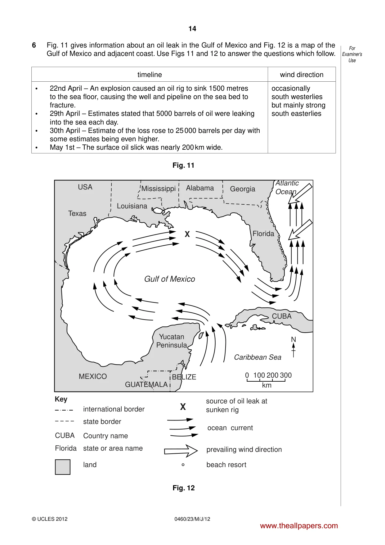
14 © UCLES 2012 0460/23/M/J/12 For Examiner’s Use 6 Fig. 11 gives information about an oil leak in the Gulf of Mexico and Fig. 12 is a map of the Gulf of Mexico and adjacent coast. Use Figs 11 and 12 to answer the questions which follow. timeline wind direction • 22nd April – An explosion caused an oil rig to sink 1500 metres to the sea floor, causing the well and pipeline on the sea bed to fracture. • 29th April – Estimates stated that 5000 barrels of oil were leaking into the sea each day. • 30th April – Estimate of the loss rose to 25 000 barrels per day with some estimates being even higher. • May 1st – The surface oil slick was nearly 200 km wide. occasionally south westerlies but mainly strong south easterlies Fig. 11 Gulf of Mexico Atlantic Ocean Caribbean Sea Key Texas Yucatan Peninsula USA Louisiana Mississippi Alabama Georgia Florida Florida CUBA MEXICO CUBA GUATEMALA GUATEMALA BELIZE international border source of oil leak at sunken rig state border ocean current prevailing wind direction beach resort Country name state or area name land X X 0 100 200 300 km N Fig. 12 www.theallpapers.com
Question paper, page 15
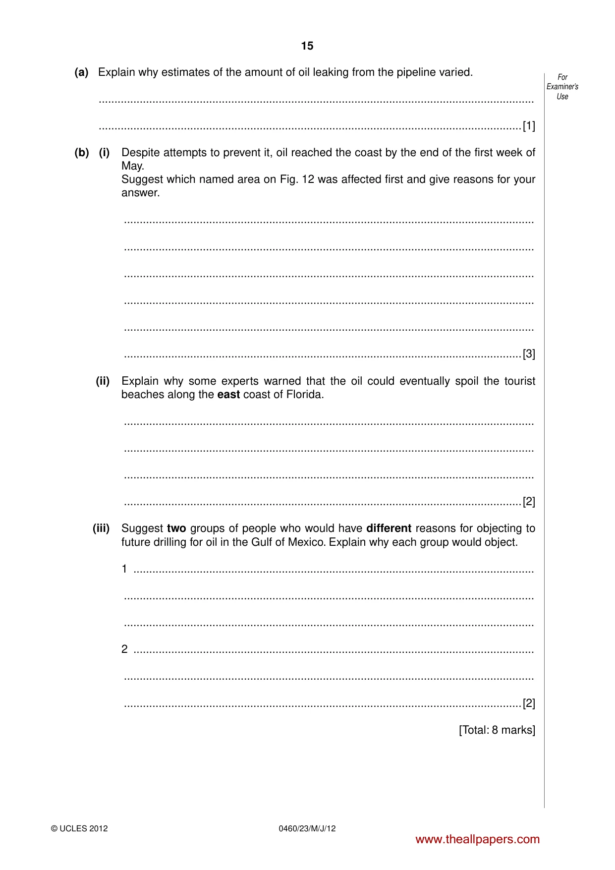
15 © UCLES 2012 0460/23/M/J/12 For Examiner’s Use (a) Explain why estimates of the amount of oil leaking from the pipeline varied. … …[1] (b) (i) Despite attempts to prevent it, oil reached the coast by the end of the first week of May. Suggest which named area on Fig. 12 was affected first and give reasons for your answer. … … … … … …[3] (ii) Explain why some experts warned that the oil could eventually spoil the tourist beaches along the east coast of Florida. … … … …[2] (iii) Suggest two groups of people who would have different reasons for objecting to future drilling for oil in the Gulf of Mexico. Explain why each group would object. 1 … … … 2 … … …[2] [Total: 8 marks] www.theallpapers.com
Question paper, page 16
16 0460/23/M/J/12 © UCLES 2012 BLANK PAGE Copyright Acknowledgements: Question 3 Photograph A © Muriel Fretwell © UCLES Question 4 Table 1 © CIA Worldfactbook ; www.cia.gov. Question 4 Fig. 6 www.cfo.gov/ph. Permission to reproduce items where third-party owned material protected by copyright is included has been sought and cleared where possible. Every reasonable effort has been made by the publisher (UCLES) to trace copyright holders, but if any items requiring clearance have unwittingly been included, the publisher will be pleased to make amends at the earliest possible opportunity. University of Cambridge International Examinations is part of the Cambridge Assessment Group. Cambridge Assessment is the brand name of University of Cambridge Local Examinations Syndicate (UCLES), which is itself a department of the University of Cambridge. www.theallpapers.com
Mark scheme, page 1
UNIVERSITY OF CAMBRIDGE INTERNATIONAL EXAMINATIONS International General Certificate of Secondary Education MARK SCHEME for the May/June 2012 question paper for the guidance of teachers 0460 GEOGRAPHY 0460/23 Paper 2, maximum raw mark 60 This mark scheme is published as an aid to teachers and candidates, to indicate the requirements of the examination. It shows the basis on which Examiners were instructed to award marks. It does not indicate the details of the discussions that took place at an Examiners’ meeting before marking began, which would have considered the acceptability of alternative answers. Mark schemes must be read in conjunction with the question papers and the report on the examination. • Cambridge will not enter into discussions or correspondence in connection with these mark schemes. Cambridge is publishing the mark schemes for the May/June 2012 question papers for most IGCSE, GCE Advanced Level and Advanced Subsidiary Level syllabuses and some Ordinary Level syllabuses. www.theallpapers.com
Mark scheme, page 2
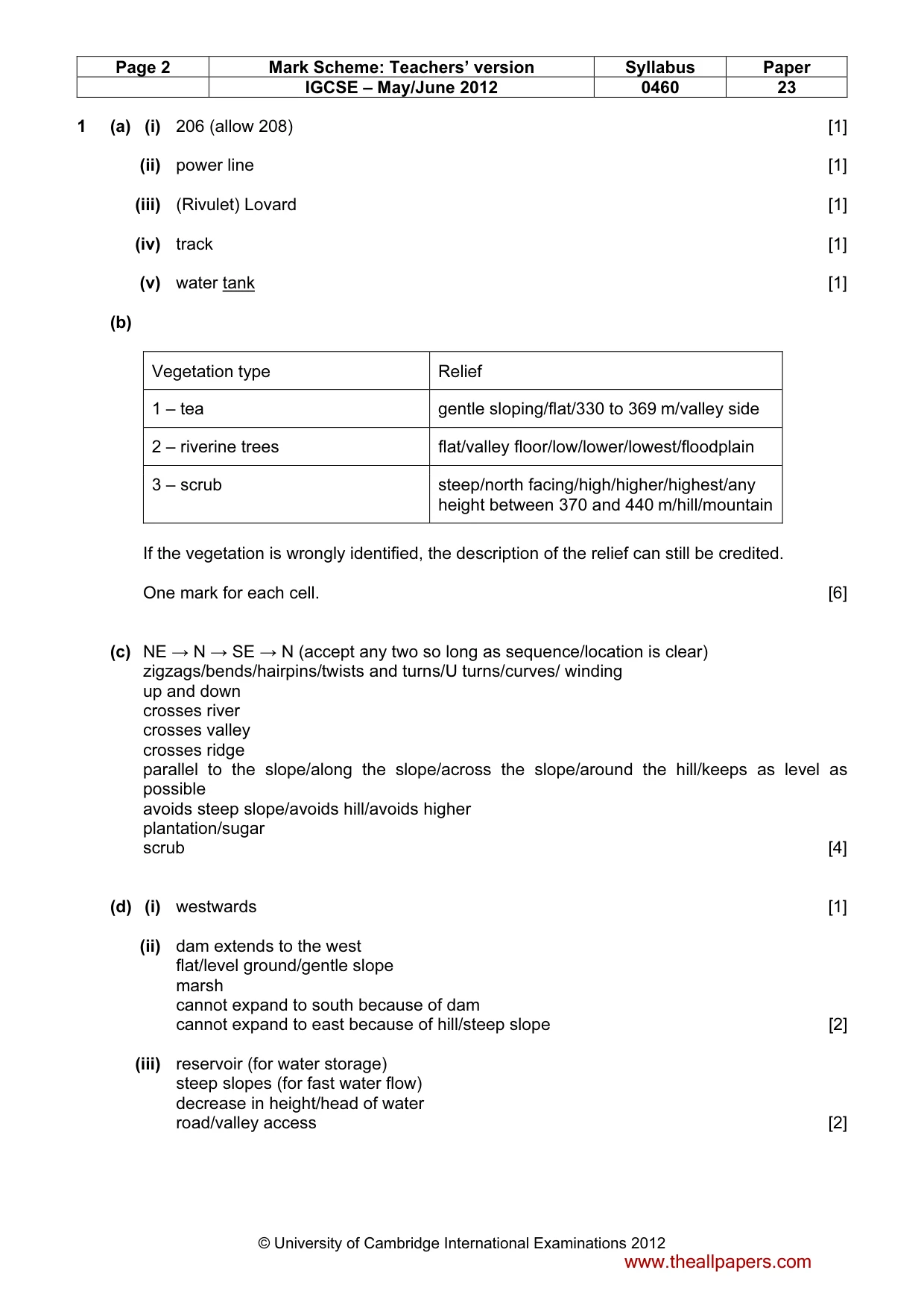
Page 2 Mark Scheme: Teachers’ version Syllabus Paper IGCSE – May/June 2012 0460 23 © University of Cambridge International Examinations 2012 1 (a) (i) 206 (allow 208) [1] (ii) power line [1] (iii) (Rivulet) Lovard [1] (iv) track [1] (v) water tank [1] (b) Vegetation type Relief 1 – tea gentle sloping/flat/330 to 369 m/valley side 2 – riverine trees flat/valley floor/low/lower/lowest/floodplain 3 – scrub steep/north facing/high/higher/highest/any height between 370 and 440 m/hill/mountain If the vegetation is wrongly identified, the description of the relief can still be credited. One mark for each cell. [6] (c) NE → N → SE → N (accept any two so long as sequence/location is clear) zigzags/bends/hairpins/twists and turns/U turns/curves/ winding up and down crosses river crosses valley crosses ridge parallel to the slope/along the slope/across the slope/around the hill/keeps as level as possible avoids steep slope/avoids hill/avoids higher plantation/sugar scrub [4] (d) (i) westwards [1] (ii) dam extends to the west flat/level ground/gentle slope marsh cannot expand to south because of dam cannot expand to east because of hill/steep slope [2] (iii) reservoir (for water storage) steep slopes (for fast water flow) decrease in height/head of water road/valley access [2] www.theallpapers.com
Mark scheme, page 3
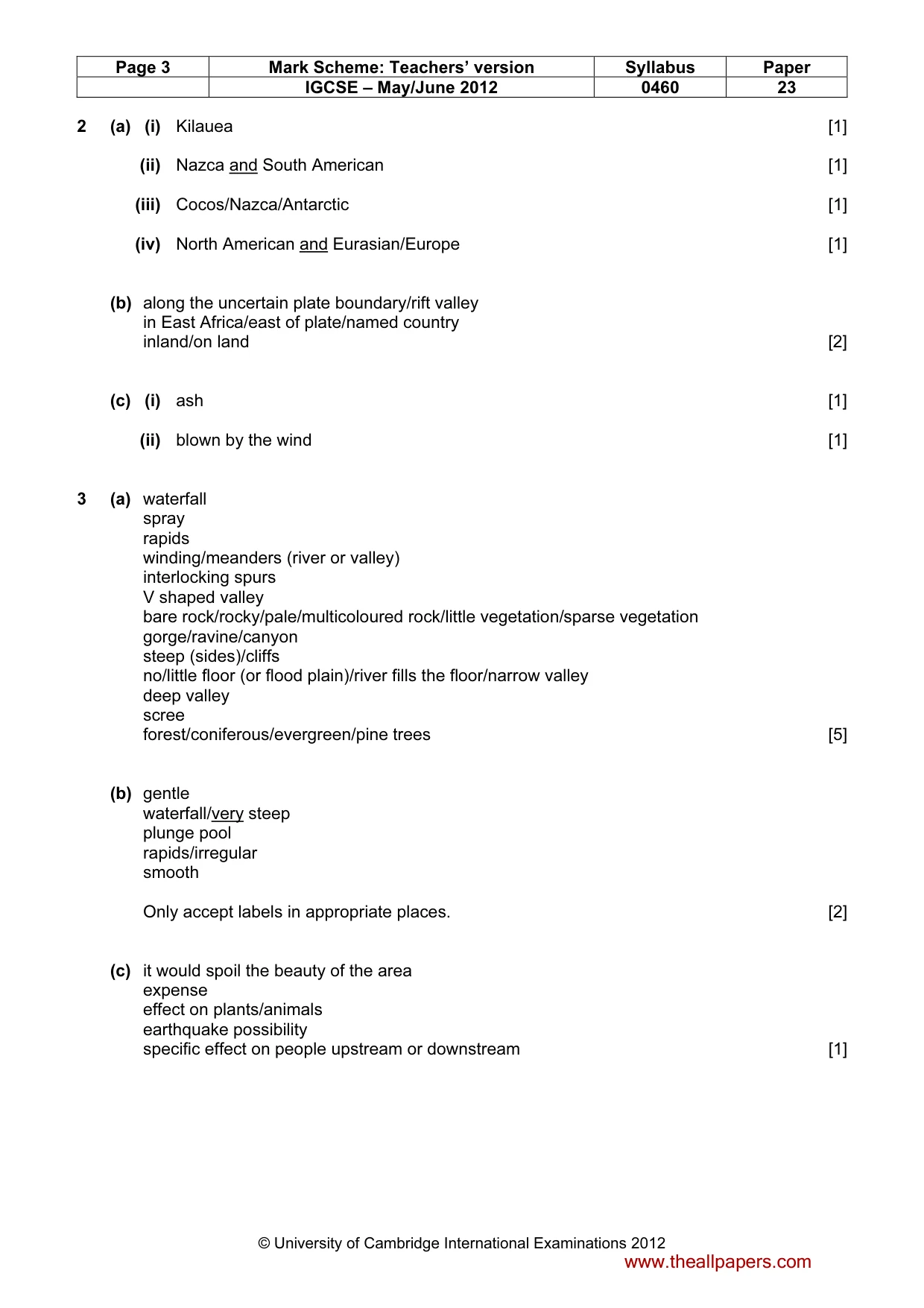
Page 3 Mark Scheme: Teachers’ version Syllabus Paper IGCSE – May/June 2012 0460 23 © University of Cambridge International Examinations 2012 2 (a) (i) Kilauea [1] (ii) Nazca and South American [1] (iii) Cocos/Nazca/Antarctic [1] (iv) North American and Eurasian/Europe [1] (b) along the uncertain plate boundary/rift valley in East Africa/east of plate/named country inland/on land [2] (c) (i) ash [1] (ii) blown by the wind [1] 3 (a) waterfall spray rapids winding/meanders (river or valley) interlocking spurs V shaped valley bare rock/rocky/pale/multicoloured rock/little vegetation/sparse vegetation gorge/ravine/canyon steep (sides)/cliffs no/little floor (or flood plain)/river fills the floor/narrow valley deep valley scree forest/coniferous/evergreen/pine trees [5] (b) gentle waterfall/very steep plunge pool rapids/irregular smooth Only accept labels in appropriate places. [2] (c) it would spoil the beauty of the area expense effect on plants/animals earthquake possibility specific effect on people upstream or downstream [1] www.theallpapers.com
Mark scheme, page 4
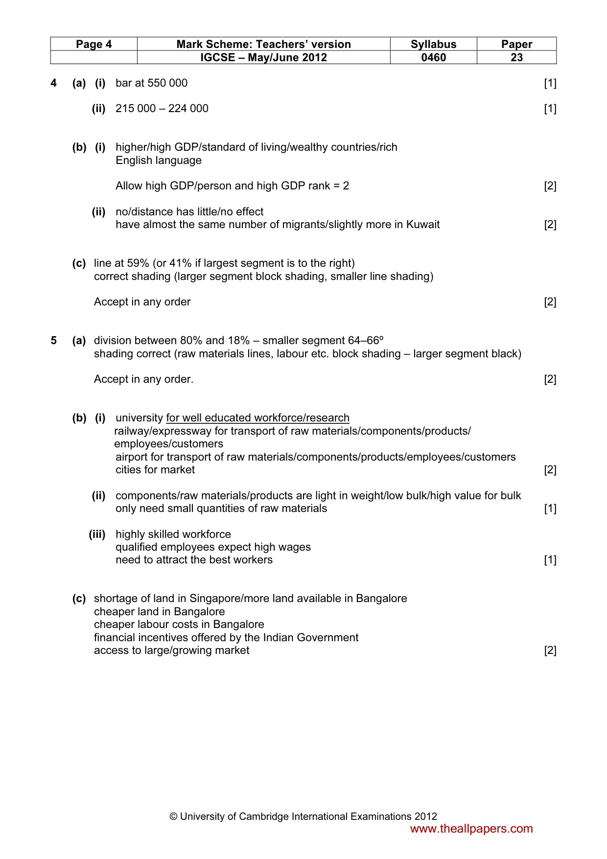
Page 4 Mark Scheme: Teachers’ version Syllabus Paper IGCSE – May/June 2012 0460 23 © University of Cambridge International Examinations 2012 4 (a) (i) bar at 550 000 [1] (ii) 215 000 – 224 000 [1] (b) (i) higher/high GDP/standard of living/wealthy countries/rich English language Allow high GDP/person and high GDP rank = 2 [2] (ii) no/distance has little/no effect have almost the same number of migrants/slightly more in Kuwait [2] (c) line at 59% (or 41% if largest segment is to the right) correct shading (larger segment block shading, smaller line shading) Accept in any order [2] 5 (a) division between 80% and 18% – smaller segment 64–66º shading correct (raw materials lines, labour etc. block shading – larger segment black) Accept in any order. [2] (b) (i) university for well educated workforce/research railway/expressway for transport of raw materials/components/products/ employees/customers airport for transport of raw materials/components/products/employees/customers cities for market [2] (ii) components/raw materials/products are light in weight/low bulk/high value for bulk only need small quantities of raw materials [1] (iii) highly skilled workforce qualified employees expect high wages need to attract the best workers [1] (c) shortage of land in Singapore/more land available in Bangalore cheaper land in Bangalore cheaper labour costs in Bangalore financial incentives offered by the Indian Government access to large/growing market [2] www.theallpapers.com
Mark scheme, page 5
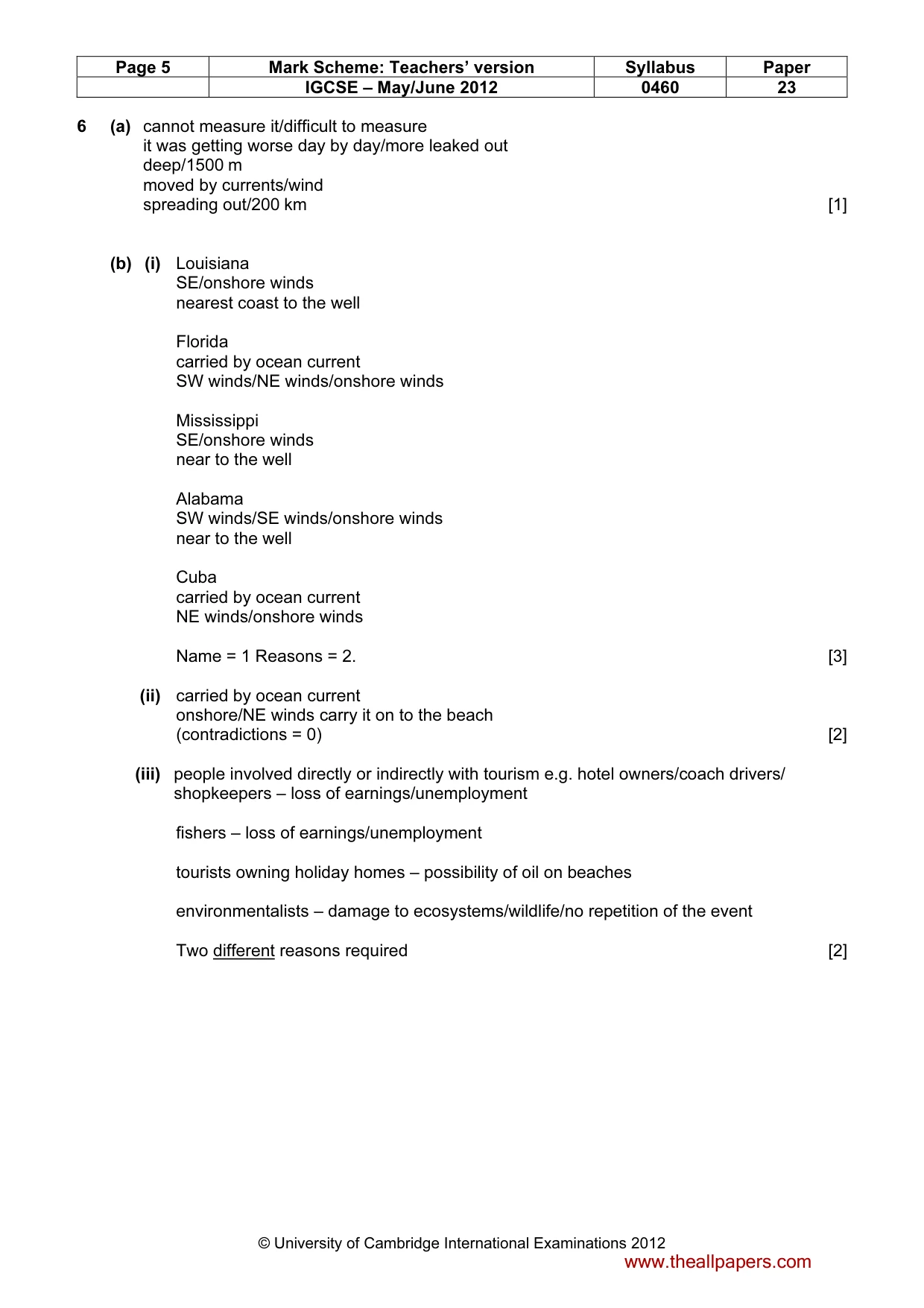
Page 5 Mark Scheme: Teachers’ version Syllabus Paper IGCSE – May/June 2012 0460 23 © University of Cambridge International Examinations 2012 6 (a) cannot measure it/difficult to measure it was getting worse day by day/more leaked out deep/1500 m moved by currents/wind spreading out/200 km [1] (b) (i) Louisiana SE/onshore winds nearest coast to the well Florida carried by ocean current SW winds/NE winds/onshore winds Mississippi SE/onshore winds near to the well Alabama SW winds/SE winds/onshore winds near to the well Cuba carried by ocean current NE winds/onshore winds Name = 1 Reasons = 2. [3] (ii) carried by ocean current onshore/NE winds carry it on to the beach (contradictions = 0) [2] (iii) people involved directly or indirectly with tourism e.g. hotel owners/coach drivers/ shopkeepers – loss of earnings/unemployment fishers – loss of earnings/unemployment tourists owning holiday homes – possibility of oil on beaches environmentalists – damage to ecosystems/wildlife/no repetition of the event Two different reasons required [2] www.theallpapers.com
What you needed in this session
Cambridge’s own grade thresholds for 2012 May/June, Paper 2 · Variant 3. A higher threshold means an easier paper — the bar moves with how the cohort did.