Cambridge IGCSE Geography 0460 — 2011 Oct/Nov Paper 2 · Variant 1
0460/21/O/N/11 · 60 marks · ≈68 min
The question paper and its mark scheme, free to read here and free to download. This is Cambridge’s own paper, exactly as it was sat.
Question paper16 pages


Mark scheme5 pages
Answers below. Sit the paper first if you are practising.
Paper as text
Question paper, page 1
This document consists of 14 printed pages and 2 blank pages and 1 Insert. DC (NF/DJ) 33787/2 © UCLES 2011 [Turn over UNIVERSITY OF CAMBRIDGE INTERNATIONAL EXAMINATIONS International General Certificate of Secondary Education * 5 0 2 0 3 7 7 3 1 8 * GEOGRAPHY 0460/21 Paper 2 October/November 2011 1 hour 30 minutes Candidates answer on the Question Paper. Additional Materials: Ruler Protractor Plain paper 1:50 000 Survey Map Extract is enclosed with this Question Paper. READ THESE INSTRUCTIONS FIRST Write your Centre number, candidate number and name in the spaces provided. Write in dark blue or black pen. You may use a soft pencil for any diagrams, graphs or rough working. Do not use staples, paper clips, highlighters, glue or correction fluid. DO NOT WRITE IN ANY BARCODES. Answer all questions. The Insert contains Photographs A, B and C for Question 4 and Photograph D for Question 6. Sketch maps and diagrams should be drawn whenever they serve to illustrate an answer. The Survey Map Extract and the Insert are not required by the Examiner. At the end of the examination, fasten all your work securely together. The number of marks is given in brackets [ ] at the end of each question or part question. www.theallpapers.com
Question paper, page 2
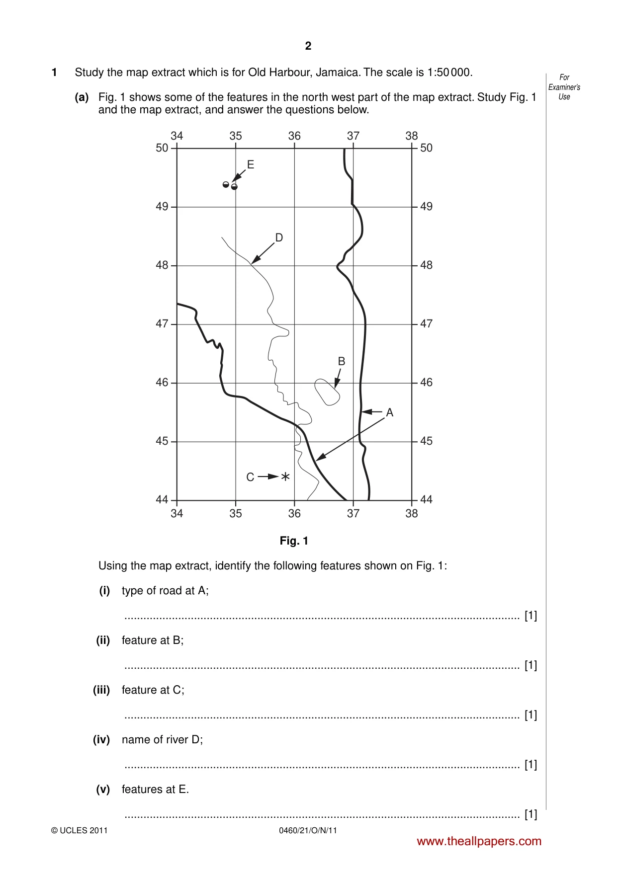
2 0460/21/O/N/11 © UCLES 2011 For Examiner’s Use 1 Study the map extract which is for Old Harbour, Jamaica. The scale is 1:50 000. (a) Fig. 1 shows some of the features in the north west part of the map extract. Study Fig. 1 and the map extract, and answer the questions below. 50 34 35 36 37 38 34 35 36 37 38 47 46 45 44 50 47 48 48 49 49 46 45 44 C A B D E Fig. 1 Using the map extract, identify the following features shown on Fig. 1: (i) type of road at A; … [1] (ii) feature at B; … [1] (iii) feature at C; … [1] (iv) name of river D; … [1] (v) features at E. … [1] www.theallpapers.com
Question paper, page 3
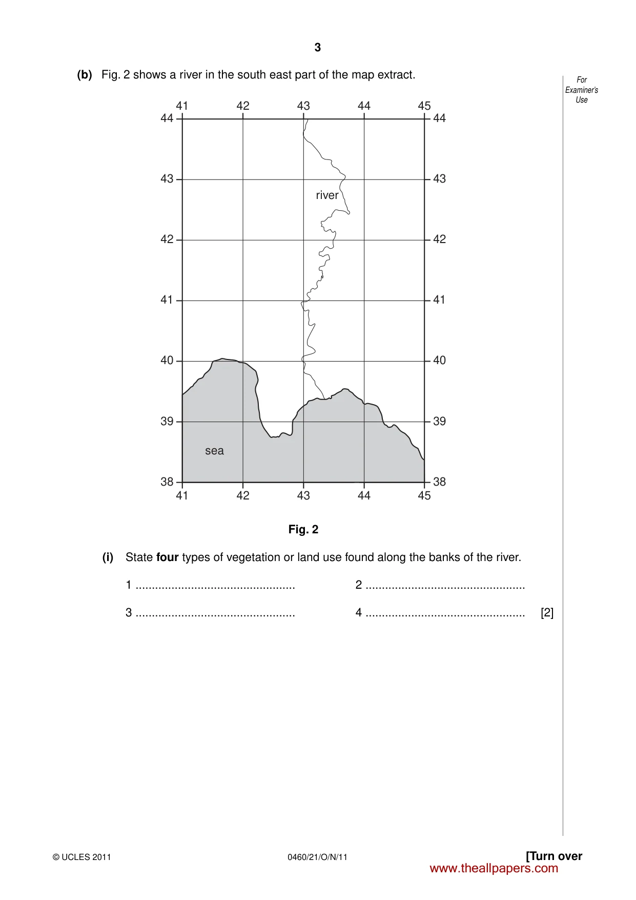
3 0460/21/O/N/11 © UCLES 2011 [Turn over For Examiner’s Use (b) Fig. 2 shows a river in the south east part of the map extract. 44 41 42 43 44 45 41 42 43 44 45 41 40 39 38 44 41 42 42 43 43 40 39 38 sea river Fig. 2 (i) State four types of vegetation or land use found along the banks of the river. 1 … 2 … 3 … 4 … [2] www.theallpapers.com
Question paper, page 4
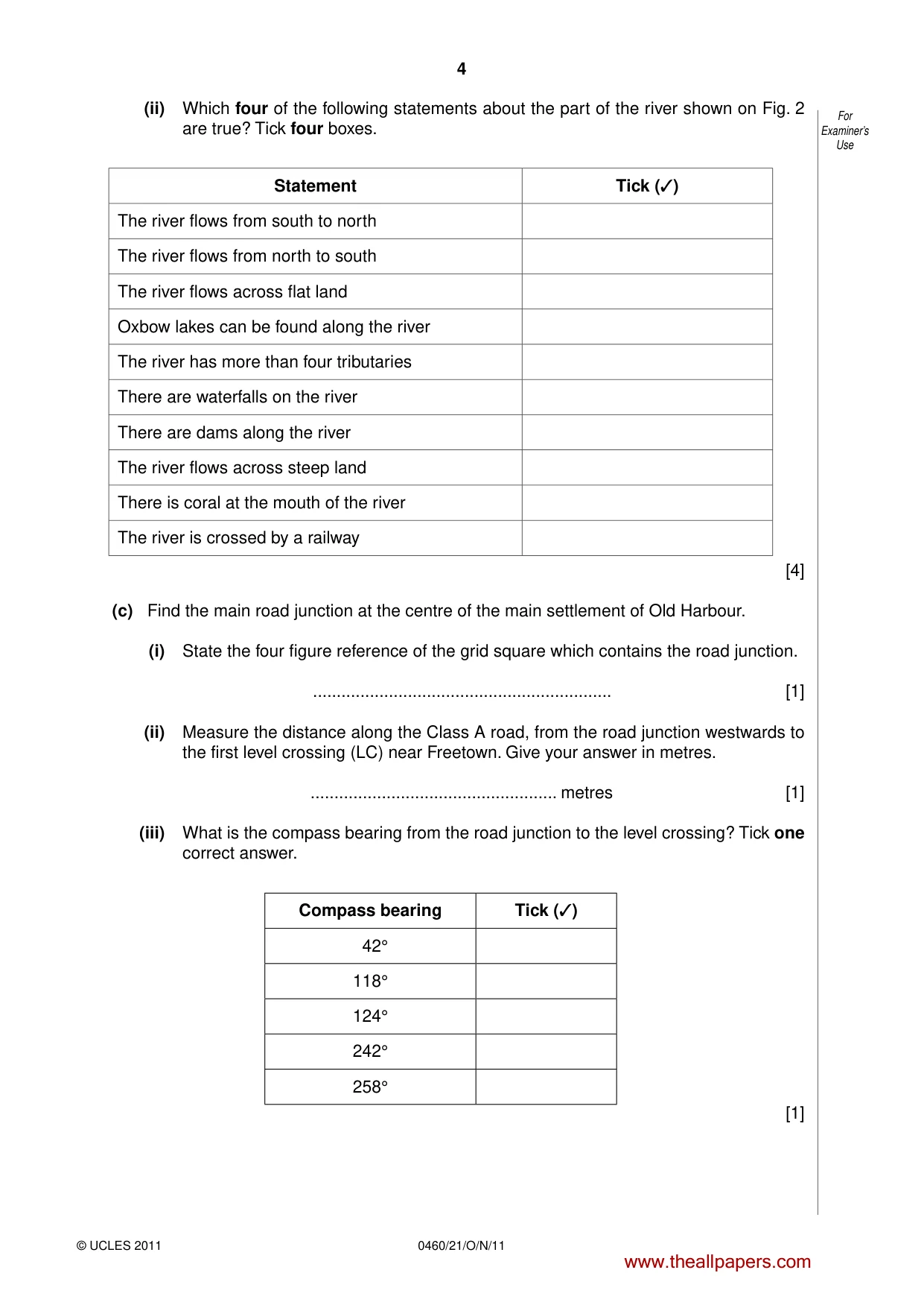
4 0460/21/O/N/11 © UCLES 2011 For Examiner’s Use (ii) Which four of the following statements about the part of the river shown on Fig. 2 are true? Tick four boxes. Statement Tick (✓) The river flows from south to north The river flows from north to south The river flows across flat land Oxbow lakes can be found along the river The river has more than four tributaries There are waterfalls on the river There are dams along the river The river flows across steep land There is coral at the mouth of the river The river is crossed by a railway [4] (c) Find the main road junction at the centre of the main settlement of Old Harbour. (i) State the four figure reference of the grid square which contains the road junction. … [1] (ii) Measure the distance along the Class A road, from the road junction westwards to the first level crossing (LC) near Freetown. Give your answer in metres. … metres [1] (iii) What is the compass bearing from the road junction to the level crossing? Tick one correct answer. Compass bearing Tick (✓) 42° 118° 124° 242° 258° [1] www.theallpapers.com
Question paper, page 5
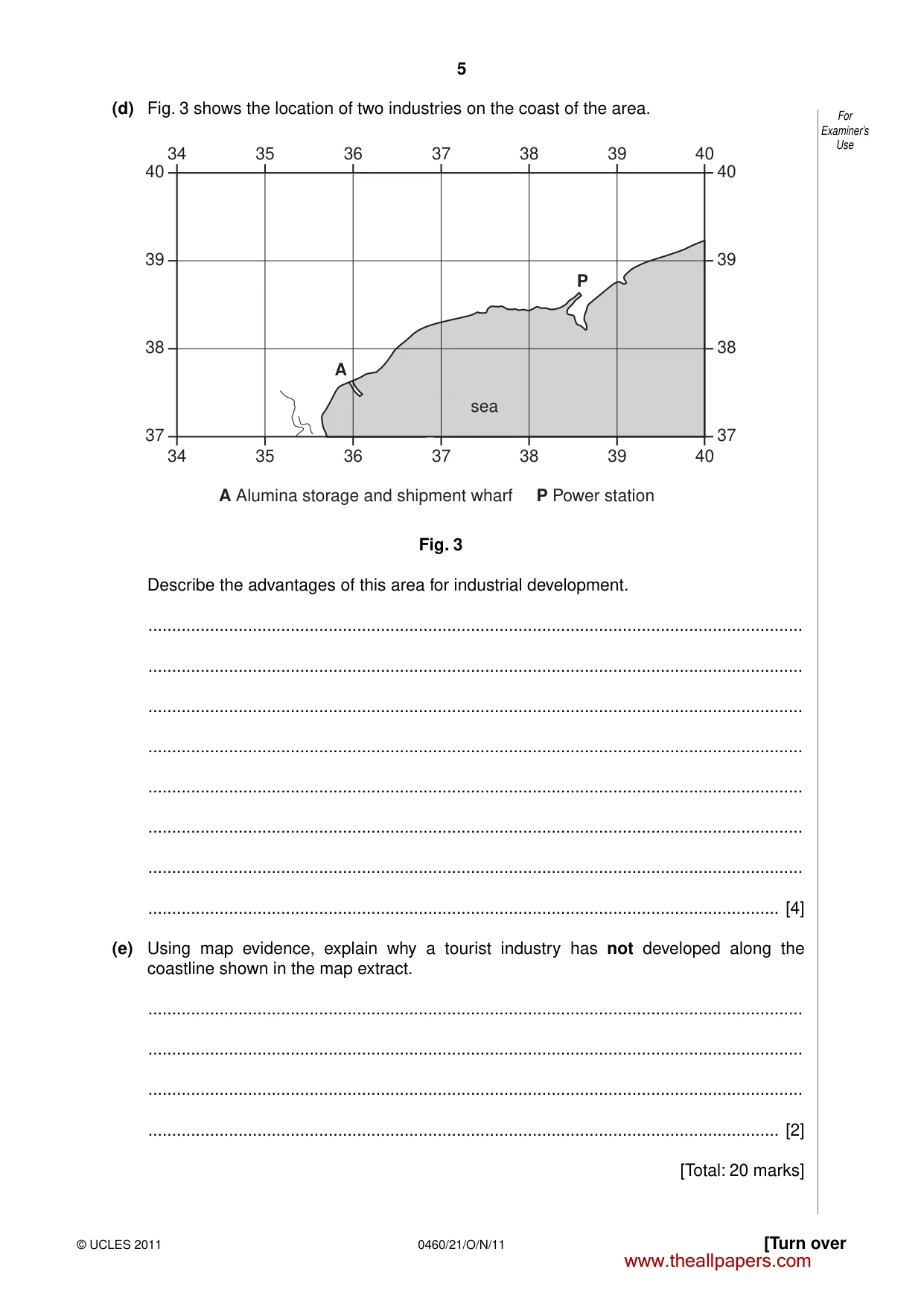
5 0460/21/O/N/11 © UCLES 2011 [Turn over For Examiner’s Use (d) Fig. 3 shows the location of two industries on the coast of the area. 34 35 36 37 40 34 35 36 37 38 38 39 39 40 40 39 38 37 40 39 38 37 sea A P A Alumina storage and shipment wharf P Power station Fig. 3 Describe the advantages of this area for industrial development. … … … … … … … … [4] (e) Using map evidence, explain why a tourist industry has not developed along the coastline shown in the map extract. … … … … [2] [Total: 20 marks] www.theallpapers.com
Question paper, page 6
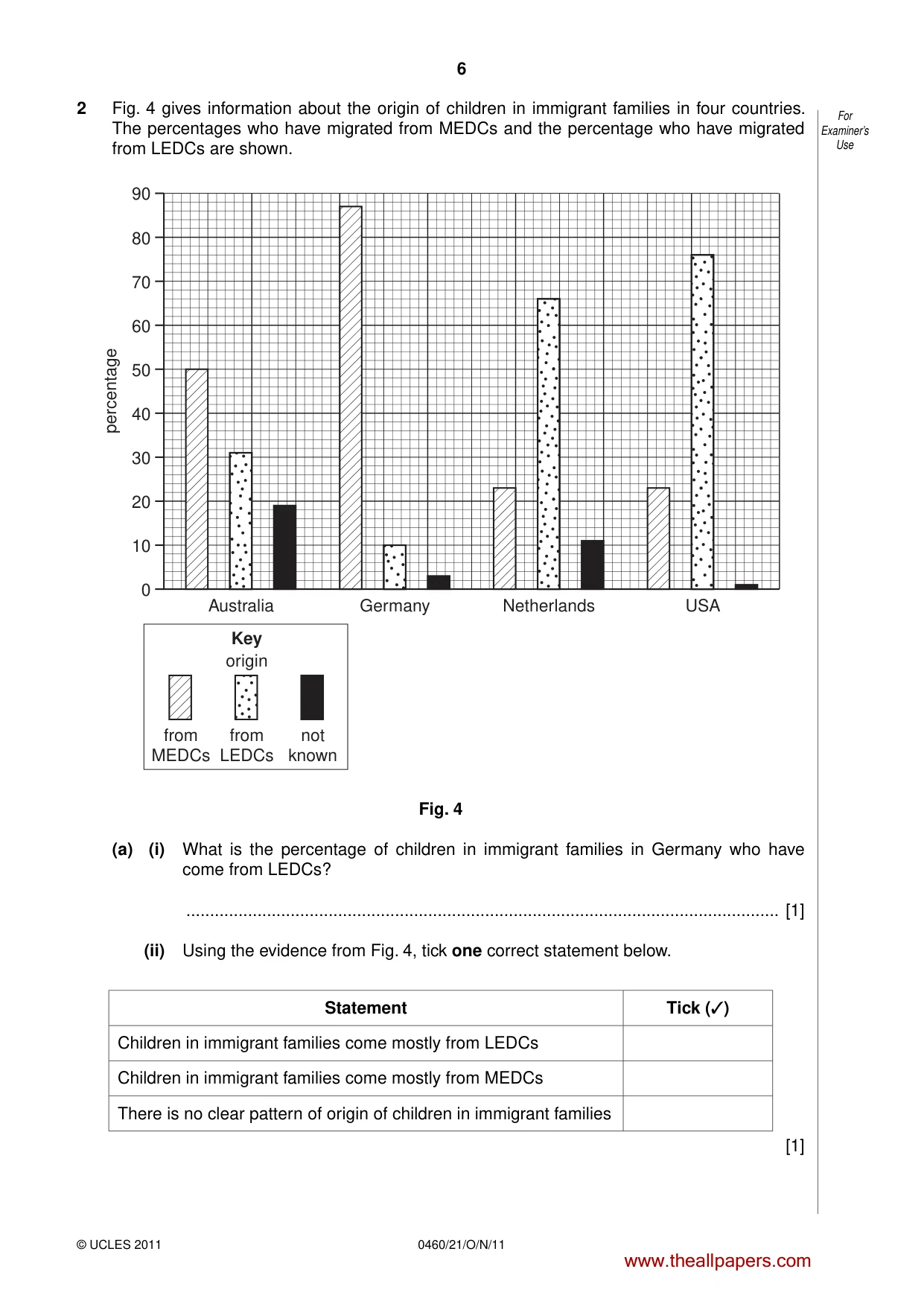
6 0460/21/O/N/11 © UCLES 2011 For Examiner’s Use 2 Fig. 4 gives information about the origin of children in immigrant families in four countries. The percentages who have migrated from MEDCs and the percentage who have migrated from LEDCs are shown. 0 0 Australia 10 20 30 40 50 percentage 60 70 80 90 Germany Key origin from LEDCs not known from MEDCs Netherlands USA Fig. 4 (a) (i) What is the percentage of children in immigrant families in Germany who have come from LEDCs? … [1] (ii) Using the evidence from Fig. 4, tick one correct statement below. Statement Tick (✓) Children in immigrant families come mostly from LEDCs Children in immigrant families come mostly from MEDCs There is no clear pattern of origin of children in immigrant families [1] www.theallpapers.com
Question paper, page 7
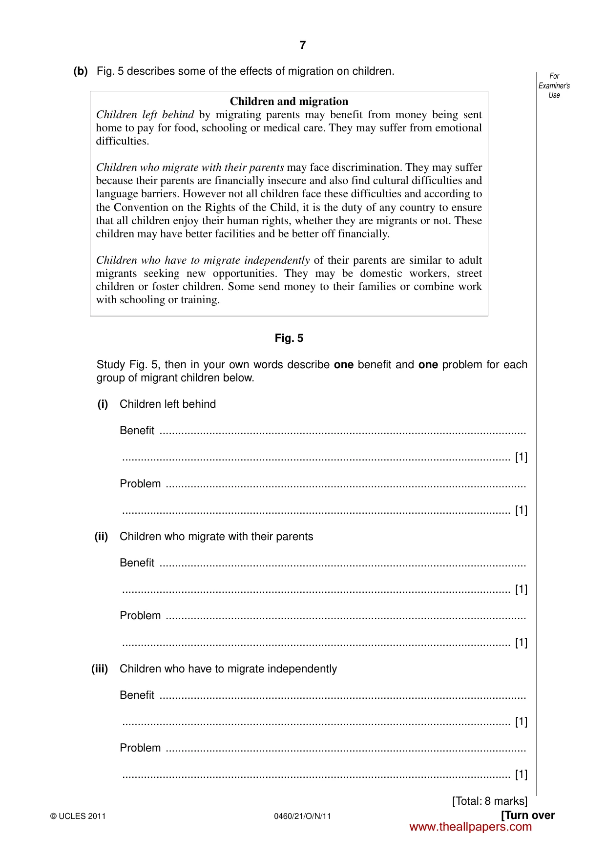
7 0460/21/O/N/11 © UCLES 2011 [Turn over For Examiner’s Use (b) Fig. 5 describes some of the effects of migration on children. Children and migration Children left behind by migrating parents may benefit from money being sent home to pay for food, schooling or medical care. They may suffer from emotional difficulties. Children who migrate with their parents may face discrimination. They may suffer because their parents are financially insecure and also find cultural difficulties and language barriers. However not all children face these difficulties and according to the Convention on the Rights of the Child, it is the duty of any country to ensure that all children enjoy their human rights, whether they are migrants or not. These children may have better facilities and be better off financially. Children who have to migrate independently of their parents are similar to adult migrants seeking new opportunities. They may be domestic workers, street children or foster children. Some send money to their families or combine work with schooling or training. Fig. 5 Study Fig. 5, then in your own words describe one benefit and one problem for each group of migrant children below. (i) Children left behind Benefit … … [1] Problem … … [1] (ii) Children who migrate with their parents Benefit … … [1] Problem … … [1] (iii) Children who have to migrate independently Benefit … … [1] Problem … … [1] [Total: 8 marks] www.theallpapers.com
Question paper, page 8
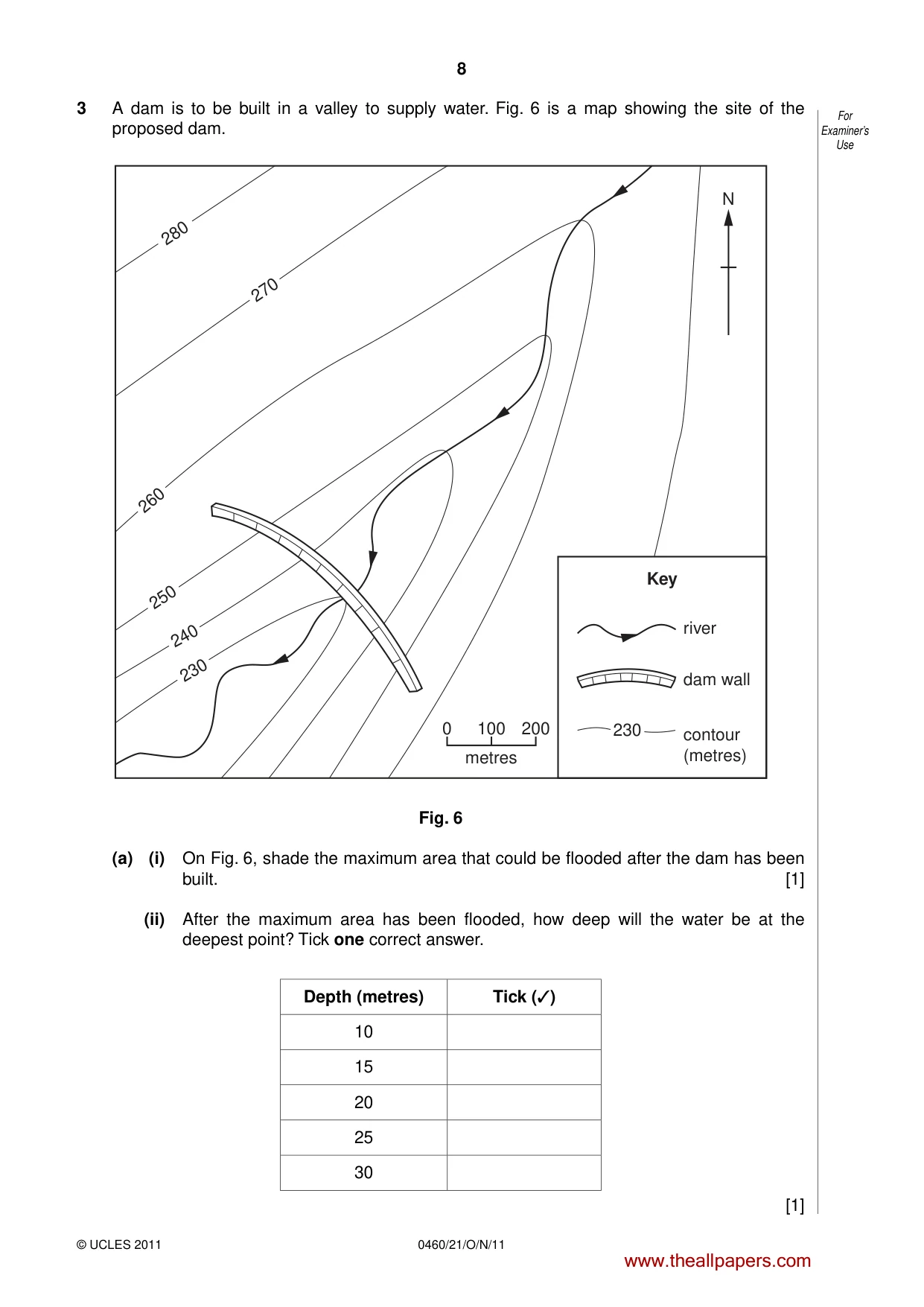
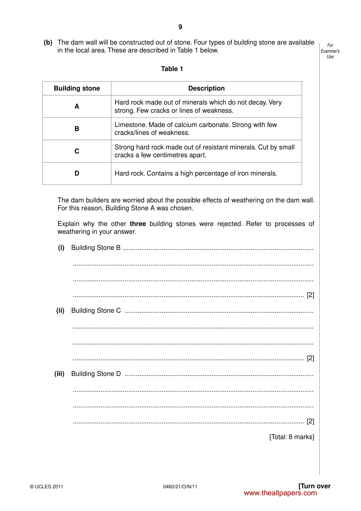
8 0460/21/O/N/11 © UCLES 2011 For Examiner’s Use 3 A dam is to be built in a valley to supply water. Fig. 6 is a map showing the site of the proposed dam. 280 270 260 250 240 230 N Key river dam wall 230 0 100 200 metres contour (metres) Fig. 6 (a) (i) On Fig. 6, shade the maximum area that could be flooded after the dam has been built. [1] (ii) After the maximum area has been flooded, how deep will the water be at the deepest point? Tick one correct answer. Depth (metres) Tick (✓) 10 15 20 25 30 [1] www.theallpapers.com
Question paper, page 9
9 0460/21/O/N/11 © UCLES 2011 [Turn over For Examiner’s Use (b) The dam wall will be constructed out of stone. Four types of building stone are available in the local area. These are described in Table 1 below. Table 1 Building stone Description A Hard rock made out of minerals which do not decay. Very strong. Few cracks or lines of weakness. B Limestone. Made of calcium carbonate. Strong with few cracks/lines of weakness. C Strong hard rock made out of resistant minerals. Cut by small cracks a few centimetres apart. D Hard rock. Contains a high percentage of iron minerals. The dam builders are worried about the possible effects of weathering on the dam wall. For this reason, Building Stone A was chosen. Explain why the other three building stones were rejected. Refer to processes of weathering in your answer. (i) Building Stone B … … … … [2] (ii) Building Stone C … … … … [2] (iii) Building Stone D … … … … [2] [Total: 8 marks] www.theallpapers.com
Question paper, page 10
10 0460/21/O/N/11 © UCLES 2011 BLANK PAGE www.theallpapers.com
Question paper, page 11
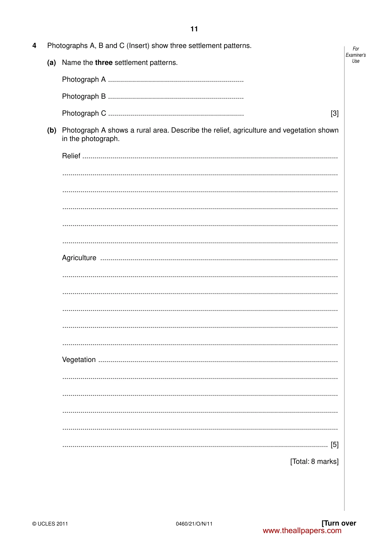
11 0460/21/O/N/11 © UCLES 2011 [Turn over For Examiner’s Use 4 Photographs A, B and C (Insert) show three settlement patterns. (a) Name the three settlement patterns. Photograph A … Photograph B … Photograph C … [3] (b) Photograph A shows a rural area. Describe the relief, agriculture and vegetation shown in the photograph. Relief … … … … … … Agriculture … … … … … … Vegetation … … … … … … [5] [Total: 8 marks] www.theallpapers.com
Question paper, page 12
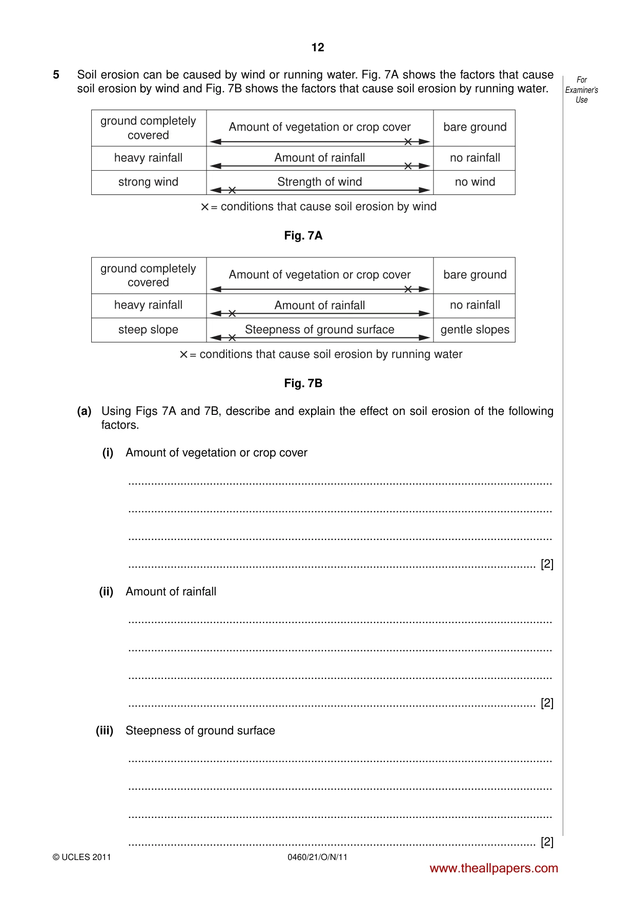
12 0460/21/O/N/11 © UCLES 2011 For Examiner’s Use 5 Soil erosion can be caused by wind or running water. Fig. 7A shows the factors that cause soil erosion by wind and Fig. 7B shows the factors that cause soil erosion by running water. ground completely covered strong wind heavy rainfall Amount of vegetation or crop cover Strength of wind = conditions that cause soil erosion by wind Amount of rainfall bare ground no wind no rainfall Fig. 7A ground completely covered steep slope heavy rainfall Amount of vegetation or crop cover Steepness of ground surface = conditions that cause soil erosion by running water Amount of rainfall bare ground gentle slopes no rainfall Fig. 7B (a) Using Figs 7A and 7B, describe and explain the effect on soil erosion of the following factors. (i) Amount of vegetation or crop cover … … … … [2] (ii) Amount of rainfall … … … … [2] (iii) Steepness of ground surface … … … … [2] www.theallpapers.com
Question paper, page 13
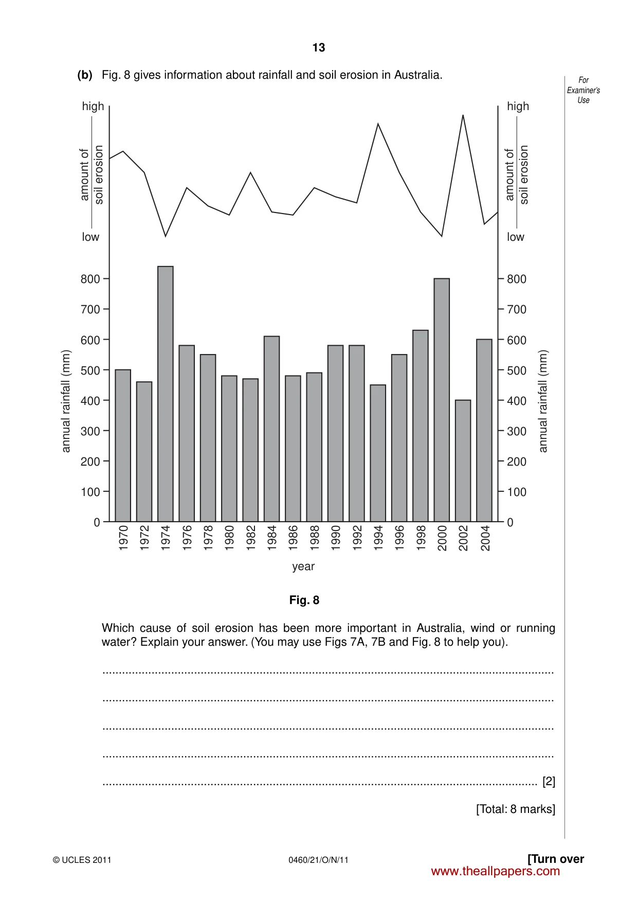
13 0460/21/O/N/11 © UCLES 2011 [Turn over For Examiner’s Use (b) Fig. 8 gives information about rainfall and soil erosion in Australia. 1970 0 100 200 300 400 500 annual rainfall (mm) annual rainfall (mm) 600 700 800 0 100 year 200 300 400 500 600 700 800 high low amount of soil erosion 1972 1974 1976 1978 1980 1982 1984 1986 1988 1990 1992 1994 1996 1998 2000 2002 2004 high low amount of soil erosion Fig. 8 Which cause of soil erosion has been more important in Australia, wind or running water? Explain your answer. (You may use Figs 7A, 7B and Fig. 8 to help you). … … … … … [2] [Total: 8 marks] www.theallpapers.com
Question paper, page 14
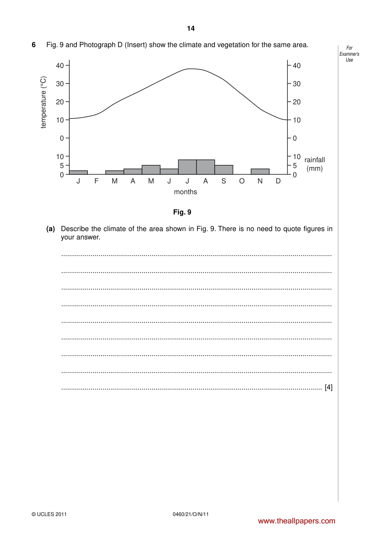
14 0460/21/O/N/11 © UCLES 2011 For Examiner’s Use 6 Fig. 9 and Photograph D (Insert) show the climate and vegetation for the same area. 0 10 5 0 10 20 30 40 temperature (°C) rainfall (mm) 0 10 5 months 0 10 20 30 40 J F M A M J J A S O N D Fig. 9 (a) Describe the climate of the area shown in Fig. 9. There is no need to quote figures in your answer. … … … … … … … … … [4] www.theallpapers.com
Question paper, page 15
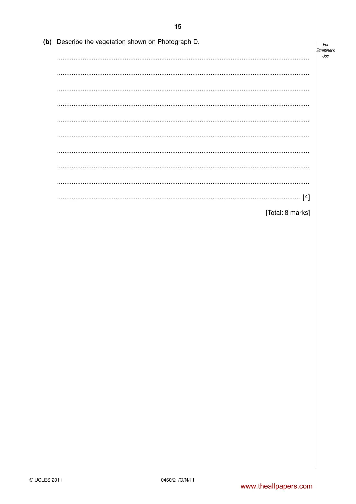
15 0460/21/O/N/11 © UCLES 2011 For Examiner’s Use (b) Describe the vegetation shown on Photograph D. … … … … … … … … … … [4] [Total: 8 marks] www.theallpapers.com
Question paper, page 16
16 0460/21/O/N/11 © UCLES 2011 BLANK PAGE Copyright Acknowledgements: Question 2 Fig. 4 © http://www.unicef-irc.org/publications/pdf/ii_immig_families.pdf; 9 August 2010. Question 2 Fig. 5 © http://www.unicef-irc.org/knowledge_pages/resource_pages/migration/index.html; 9 August 2010 Photographs A–D David Kelly; © UCLES Permission to reproduce items where third-party owned material protected by copyright is included has been sought and cleared where possible. Every reasonable effort has been made by the publisher (UCLES) to trace copyright holders, but if any items requiring clearance have unwittingly been included, the publisher will be pleased to make amends at the earliest possible opportunity. University of Cambridge International Examinations is part of the Cambridge Assessment Group. Cambridge Assessment is the brand name of University of Cambridge Local Examinations Syndicate (UCLES), which is itself a department of the University of Cambridge. www.theallpapers.com
Mark scheme, page 1
UNIVERSITY OF CAMBRIDGE INTERNATIONAL EXAMINATIONS International General Certificate of Secondary Education MARK SCHEME for the October/November 2011 question paper for the guidance of teachers 0460 GEOGRAPHY 0460/21 Paper 2, maximum raw mark 60 This mark scheme is published as an aid to teachers and candidates, to indicate the requirements of the examination. It shows the basis on which Examiners were instructed to award marks. It does not indicate the details of the discussions that took place at an Examiners’ meeting before marking began, which would have considered the acceptability of alternative answers. Mark schemes must be read in conjunction with the question papers and the report on the examination. • Cambridge will not enter into discussions or correspondence in connection with these mark schemes. Cambridge is publishing the mark schemes for the October/November 2011 question papers for most IGCSE, GCE Advanced Level and Advanced Subsidiary Level syllabuses and some Ordinary Level syllabuses. www.theallpapers.com
Mark scheme, page 2
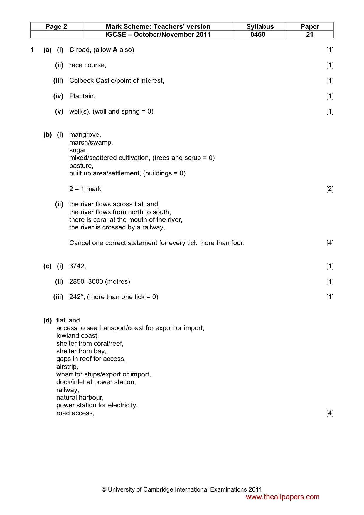
Page 2 Mark Scheme: Teachers’ version Syllabus Paper IGCSE – October/November 2011 0460 21 © University of Cambridge International Examinations 2011 1 (a) (i) C road, (allow A also) [1] (ii) race course, [1] (iii) Colbeck Castle/point of interest, [1] (iv) Plantain, [1] (v) well(s), (well and spring = 0) [1] (b) (i) mangrove, marsh/swamp, sugar, mixed/scattered cultivation, (trees and scrub = 0) pasture, built up area/settlement, (buildings = 0) 2 = 1 mark [2] (ii) the river flows across flat land, the river flows from north to south, there is coral at the mouth of the river, the river is crossed by a railway, Cancel one correct statement for every tick more than four. [4] (c) (i) 3742, [1] (ii) 2850–3000 (metres) [1] (iii) 242°, (more than one tick = 0) [1] (d) flat land, access to sea transport/coast for export or import, lowland coast, shelter from coral/reef, shelter from bay, gaps in reef for access, airstrip, wharf for ships/export or import, dock/inlet at power station, railway, natural harbour, power station for electricity, road access, [4] www.theallpapers.com
Mark scheme, page 3
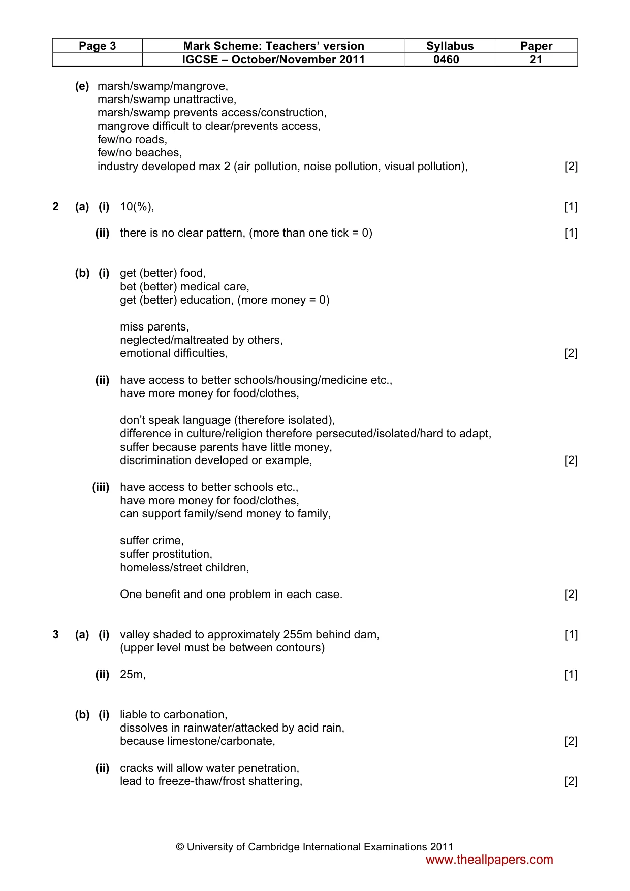
Page 3 Mark Scheme: Teachers’ version Syllabus Paper IGCSE – October/November 2011 0460 21 © University of Cambridge International Examinations 2011 (e) marsh/swamp/mangrove, marsh/swamp unattractive, marsh/swamp prevents access/construction, mangrove difficult to clear/prevents access, few/no roads, few/no beaches, industry developed max 2 (air pollution, noise pollution, visual pollution), [2] 2 (a) (i) 10(%), [1] (ii) there is no clear pattern, (more than one tick = 0) [1] (b) (i) get (better) food, bet (better) medical care, get (better) education, (more money = 0) miss parents, neglected/maltreated by others, emotional difficulties, [2] (ii) have access to better schools/housing/medicine etc., have more money for food/clothes, don’t speak language (therefore isolated), difference in culture/religion therefore persecuted/isolated/hard to adapt, suffer because parents have little money, discrimination developed or example, [2] (iii) have access to better schools etc., have more money for food/clothes, can support family/send money to family, suffer crime, suffer prostitution, homeless/street children, One benefit and one problem in each case. [2] 3 (a) (i) valley shaded to approximately 255m behind dam, [1] (upper level must be between contours) (ii) 25m, [1] (b) (i) liable to carbonation, dissolves in rainwater/attacked by acid rain, because limestone/carbonate, [2] (ii) cracks will allow water penetration, lead to freeze-thaw/frost shattering, [2] www.theallpapers.com
Mark scheme, page 4
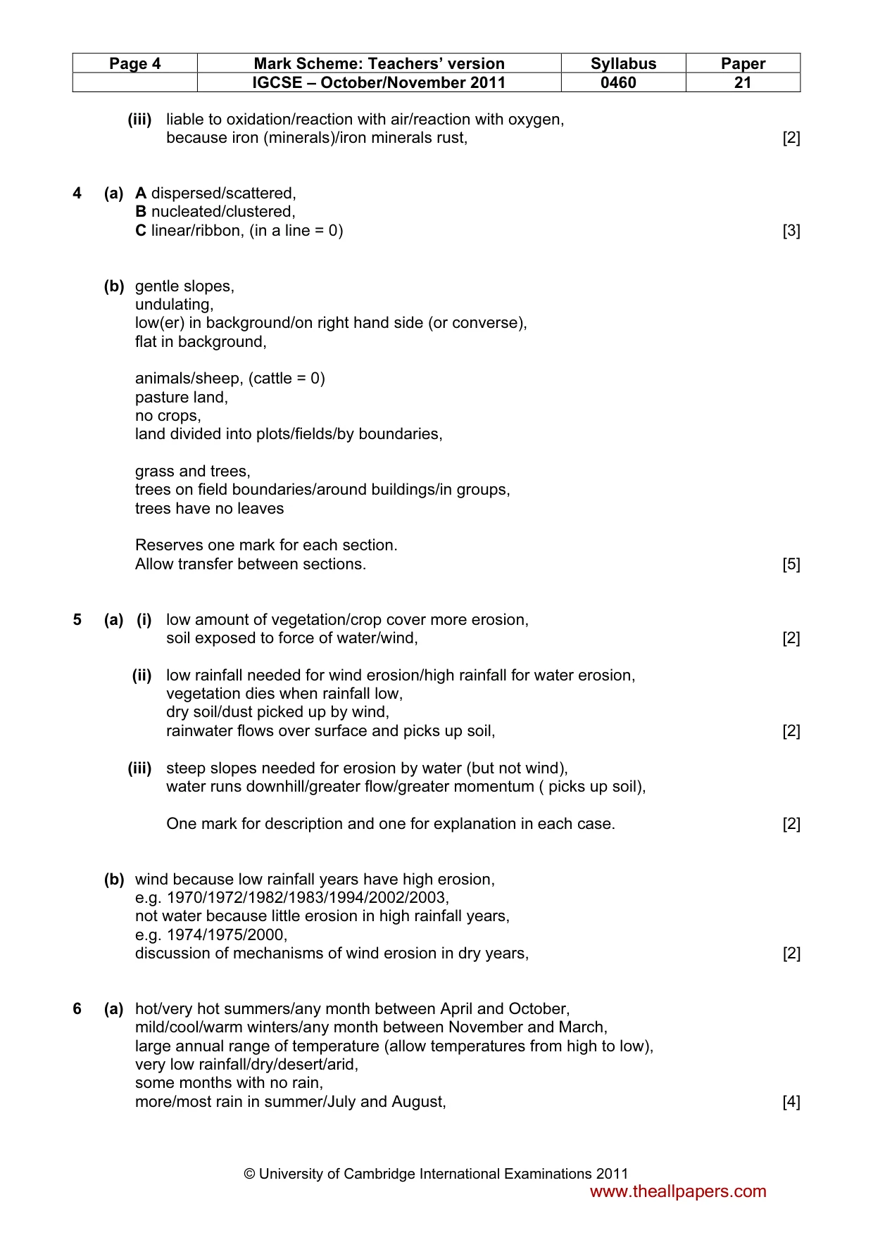
Page 4 Mark Scheme: Teachers’ version Syllabus Paper IGCSE – October/November 2011 0460 21 © University of Cambridge International Examinations 2011 (iii) liable to oxidation/reaction with air/reaction with oxygen, because iron (minerals)/iron minerals rust, [2] 4 (a) A dispersed/scattered, B nucleated/clustered, C linear/ribbon, (in a line = 0) [3] (b) gentle slopes, undulating, low(er) in background/on right hand side (or converse), flat in background, animals/sheep, (cattle = 0) pasture land, no crops, land divided into plots/fields/by boundaries, grass and trees, trees on field boundaries/around buildings/in groups, trees have no leaves Reserves one mark for each section. Allow transfer between sections. [5] 5 (a) (i) low amount of vegetation/crop cover more erosion, soil exposed to force of water/wind, [2] (ii) low rainfall needed for wind erosion/high rainfall for water erosion, vegetation dies when rainfall low, dry soil/dust picked up by wind, rainwater flows over surface and picks up soil, [2] (iii) steep slopes needed for erosion by water (but not wind), water runs downhill/greater flow/greater momentum ( picks up soil), One mark for description and one for explanation in each case. [2] (b) wind because low rainfall years have high erosion, e.g. 1970/1972/1982/1983/1994/2002/2003, not water because little erosion in high rainfall years, e.g. 1974/1975/2000, discussion of mechanisms of wind erosion in dry years, [2] 6 (a) hot/very hot summers/any month between April and October, mild/cool/warm winters/any month between November and March, large annual range of temperature (allow temperatures from high to low), very low rainfall/dry/desert/arid, some months with no rain, more/most rain in summer/July and August, [4] www.theallpapers.com
Mark scheme, page 5
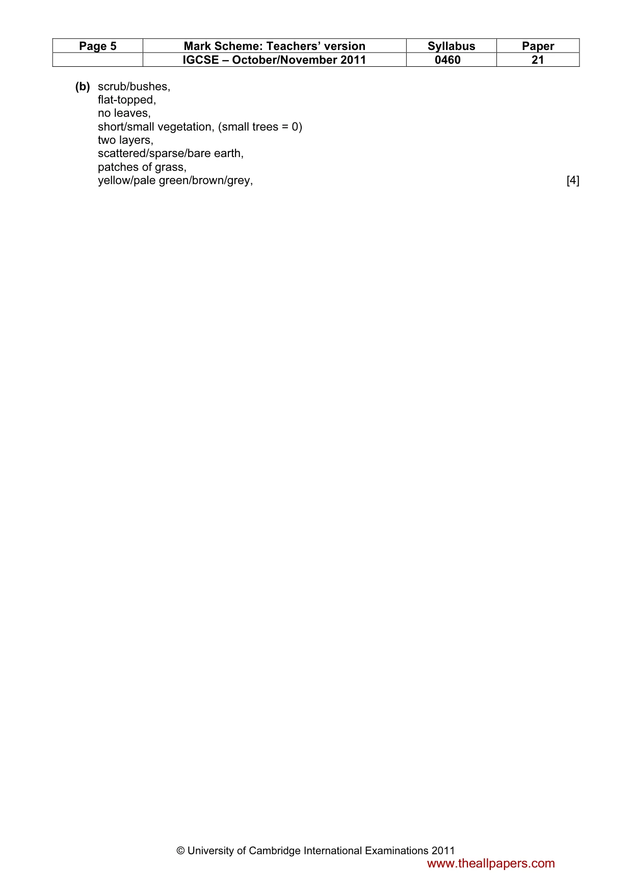
Page 5 Mark Scheme: Teachers’ version Syllabus Paper IGCSE – October/November 2011 0460 21 © University of Cambridge International Examinations 2011 (b) scrub/bushes, flat-topped, no leaves, short/small vegetation, (small trees = 0) two layers, scattered/sparse/bare earth, patches of grass, yellow/pale green/brown/grey, [4] www.theallpapers.com
What you needed in this session
Cambridge’s own grade thresholds for 2011 Oct/Nov, Paper 2 · Variant 1. A higher threshold means an easier paper — the bar moves with how the cohort did.