Cambridge IGCSE Geography 0460 — 2011 Oct/Nov Paper 2 · Variant 2
0460/22/O/N/11 · 60 marks · ≈68 min
The question paper and its mark scheme, free to read here and free to download. This is Cambridge’s own paper, exactly as it was sat.
Question paper16 pages
Mark scheme5 pages
Answers below. Sit the paper first if you are practising.
Paper as text
Question paper, page 1
This document consists of 15 printed pages, 1 blank page and 1 Insert. DC (LEO/SW) 32838/3 © UCLES 2011 [Turn over UNIVERSITY OF CAMBRIDGE INTERNATIONAL EXAMINATIONS International General Certificate of Secondary Education READ THESE INSTRUCTIONS FIRST Write your Centre number, candidate number and name in the spaces provided. Write in dark blue or black pen. You may use a soft pencil for any diagrams, graphs or rough working. Do not use staples, paper clips, highlighters, glue or correction fluid. DO NOT WRITE IN ANY BARCODES. Answer all questions. The Insert contains Photographs A and B for Question 5. Sketch maps and diagrams should be drawn whenever they serve to illustrate an answer. The Survey Map Extract and the Insert are not required by the Examiner. At the end of the examination, fasten all your work securely together. The number of marks is given in brackets [ ] at the end of each question or part question. * 0 5 8 7 5 1 9 5 6 6 * GEOGRAPHY 0460/22 Paper 2 October/November 2011 1 hour 30 minutes Candidates answer on the Question Paper. Additional Materials: Ruler Protractor Plain paper 1:25 000 Survey Map Extract is enclosed with this Question Paper. www.theallpapers.com
Question paper, page 2
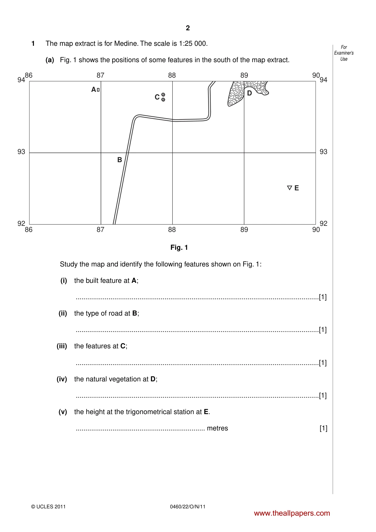
2 For Examiner’s Use 0460/22/O/N/11 © UCLES 2011 1 The map extract is for Medine. The scale is 1:25 000. (a) Fig. 1 shows the positions of some features in the south of the map extract. 94 93 92 9486 87 88 89 90 86 87 88 89 90 93 92 A C B D E Fig. 1 Study the map and identify the following features shown on Fig. 1: (i) the built feature at A; …[1] (ii) the type of road at B; …[1] (iii) the features at C; …[1] (iv) the natural vegetation at D; …[1] (v) the height at the trigonometrical station at E. … metres [1] www.theallpapers.com
Question paper, page 3
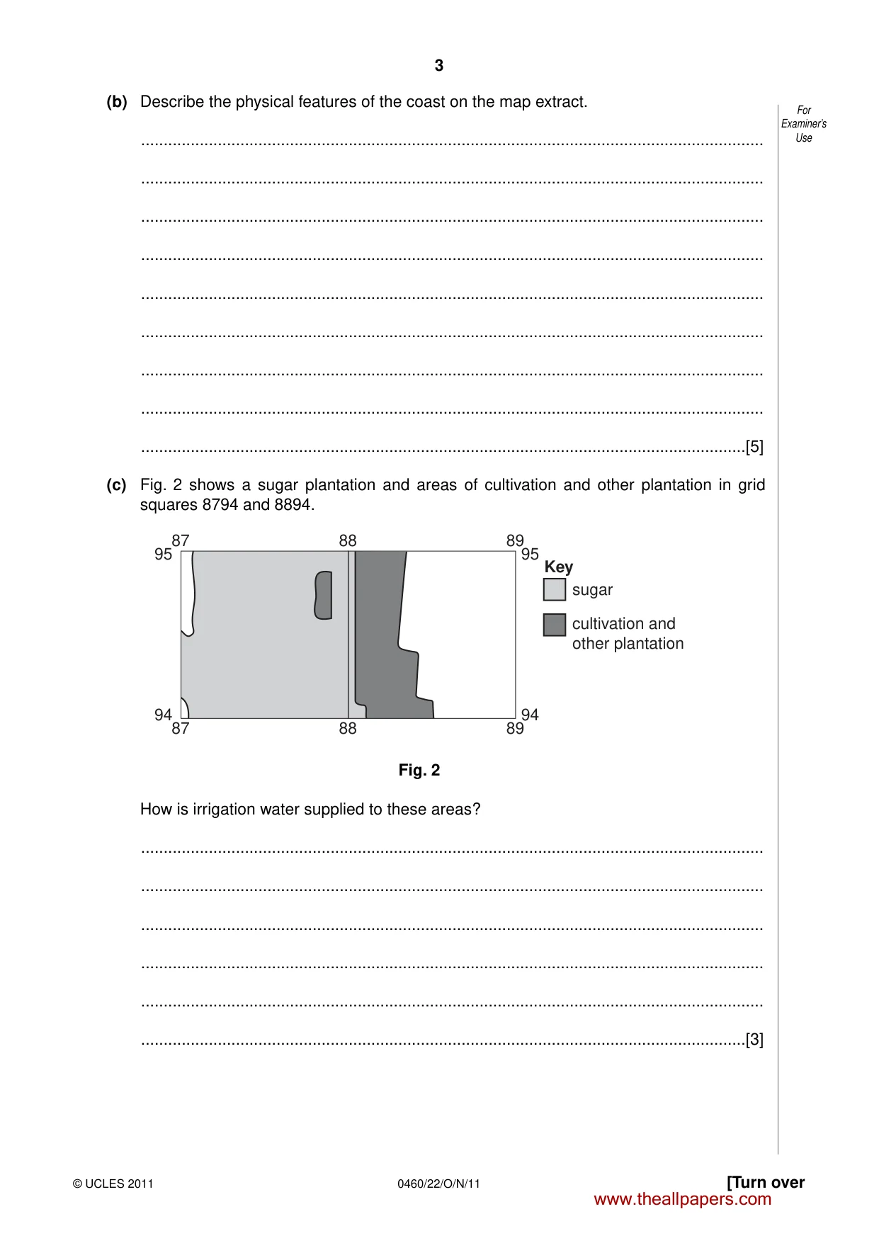
3 [Turn over For Examiner’s Use © UCLES 2011 0460/22/O/N/11 (b) Describe the physical features of the coast on the map extract. … … … … … … … … …[5] (c) Fig. 2 shows a sugar plantation and areas of cultivation and other plantation in grid squares 8794 and 8894. 87 88 89 87 88 89 95 sugar Key cultivation and other plantation 94 95 94 Fig. 2 How is irrigation water supplied to these areas? … … … … … …[3] www.theallpapers.com
Question paper, page 4
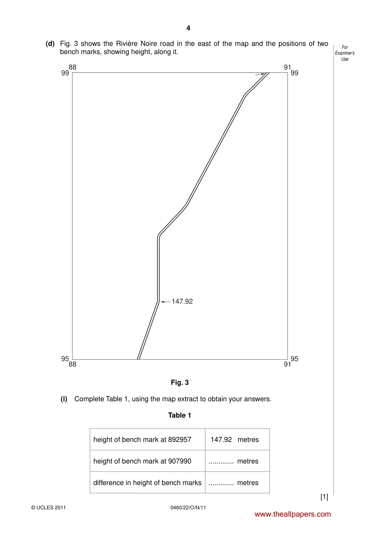
4 For Examiner’s Use 0460/22/O/N/11 © UCLES 2011 (d) Fig. 3 shows the Rivière Noire road in the east of the map and the positions of two bench marks, showing height, along it. 88 91 88 95 99 95 99 91 147.92 Fig. 3 (i) Complete Table 1, using the map extract to obtain your answers. Table 1 height of bench mark at 892957 147.92 metres height of bench mark at 907990 … metres difference in height of bench marks … metres [1] www.theallpapers.com
Question paper, page 5
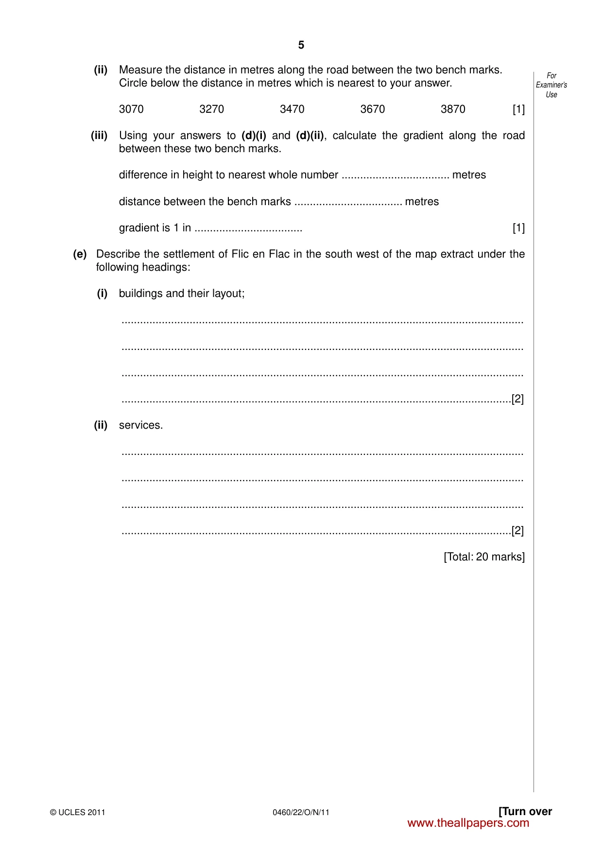
5 [Turn over For Examiner’s Use © UCLES 2011 0460/22/O/N/11 (ii) Measure the distance in metres along the road between the two bench marks. Circle below the distance in metres which is nearest to your answer. 3070 3270 3470 3670 3870 [1] (iii) Using your answers to (d)(i) and (d)(ii), calculate the gradient along the road between these two bench marks. difference in height to nearest whole number … metres distance between the bench marks … metres gradient is 1 in … [1] (e) Describe the settlement of Flic en Flac in the south west of the map extract under the following headings: (i) buildings and their layout; … … … …[2] (ii) services. … … … …[2] [Total: 20 marks] www.theallpapers.com
Question paper, page 6
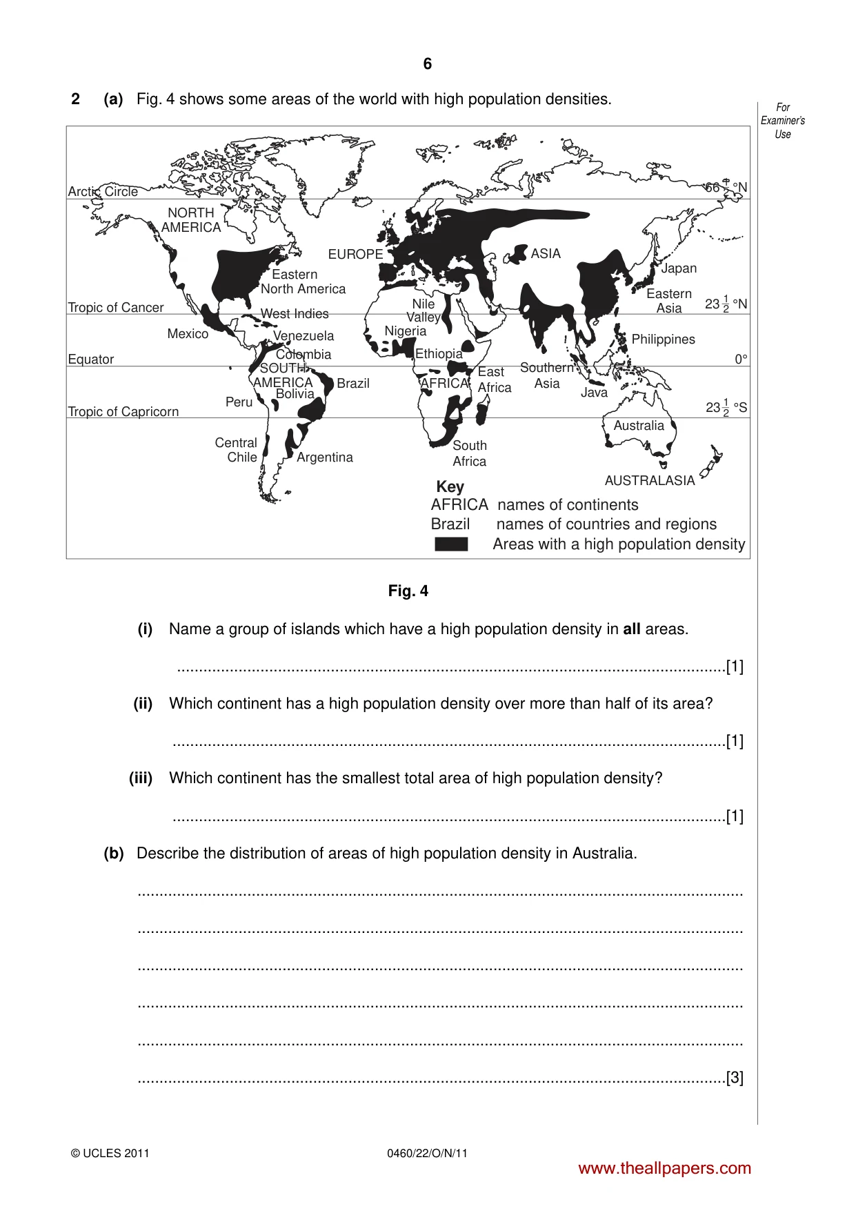
6 For Examiner’s Use 0460/22/O/N/11 © UCLES 2011 2 (a) Fig. 4 shows some areas of the world with high population densities. EUROPE Eastern North America West Indies Venezuela Brazil AFRICA AFRICA East Africa Philippines Eastern Asia Japan 66 °N 1 2 Southern Asia Java Australia AUSTRALASIA South Africa Areas with a high population density AFRICA names of continents Brazil names of countries and regions Key Nigeria Ethiopia Nile Valley Argentina Central Chile Peru Mexico Tropic of Cancer Arctic Circle Tropic of Capricorn Equator NORTH AMERICA SOUTH AMERICA SOUTH AMERICA Colombia Bolivia ASIA 23 °N 1 2 23 °S 1 2 0° Fig. 4 (i) Name a group of islands which have a high population density in all areas. …[1] (ii) Which continent has a high population density over more than half of its area? …[1] (iii) Which continent has the smallest total area of high population density? …[1] (b) Describe the distribution of areas of high population density in Australia. … … … … … …[3] www.theallpapers.com
Question paper, page 7
7 [Turn over For Examiner’s Use © UCLES 2011 0460/22/O/N/11 (c) Suggest why there are no areas of high population density north of the Arctic Circle. … … … …[2] [Total: 8 marks] www.theallpapers.com
Question paper, page 8
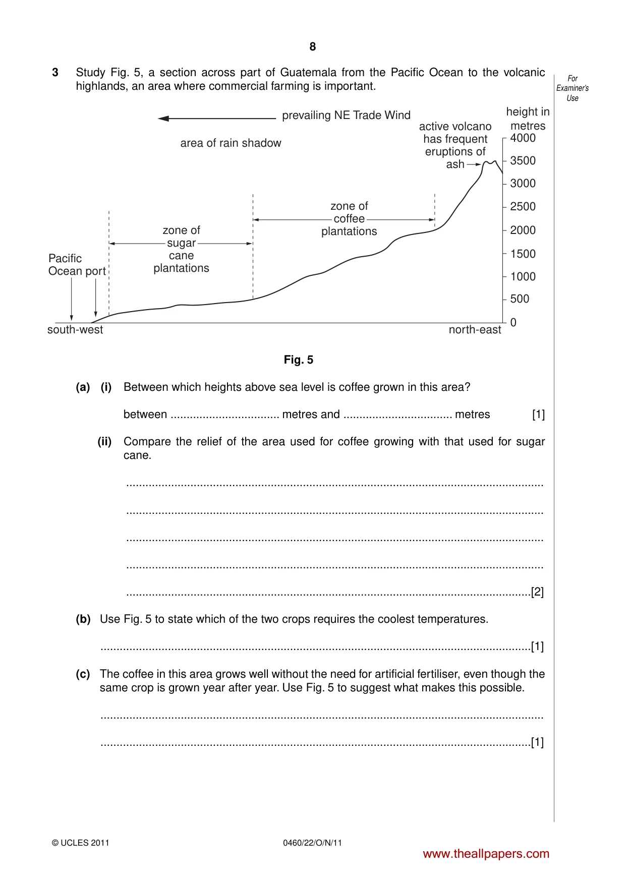
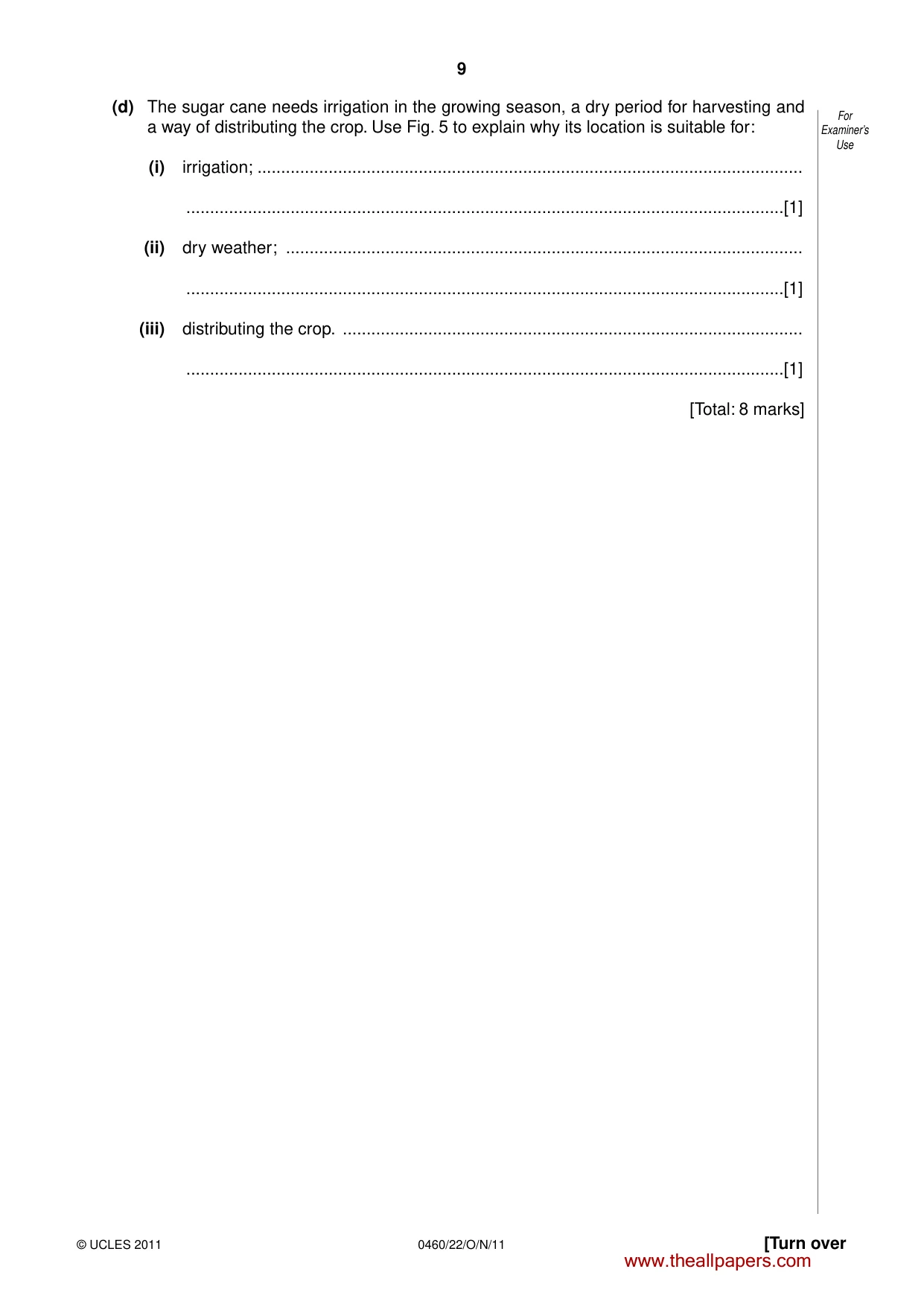
8 For Examiner’s Use 0460/22/O/N/11 © UCLES 2011 3 Study Fig. 5, a section across part of Guatemala from the Pacific Ocean to the volcanic highlands, an area where commercial farming is important. 4000 height in metres 3500 3000 2500 2000 1500 1000 500 0 Pacific Ocean port south-west north-east prevailing NE Trade Wind active volcano has frequent eruptions of ash area of rain shadow zone of sugar cane plantations zone of coffee plantations Fig. 5 (a) (i) Between which heights above sea level is coffee grown in this area? between … metres and … metres [1] (ii) Compare the relief of the area used for coffee growing with that used for sugar cane. … … … … …[2] (b) Use Fig. 5 to state which of the two crops requires the coolest temperatures. …[1] (c) The coffee in this area grows well without the need for artificial fertiliser, even though the same crop is grown year after year. Use Fig. 5 to suggest what makes this possible. … …[1] www.theallpapers.com
Question paper, page 9
9 [Turn over For Examiner’s Use © UCLES 2011 0460/22/O/N/11 (d) The sugar cane needs irrigation in the growing season, a dry period for harvesting and a way of distributing the crop. Use Fig. 5 to explain why its location is suitable for: (i) irrigation; … …[1] (ii) dry weather; … …[1] (iii) distributing the crop. … …[1] [Total: 8 marks] www.theallpapers.com
Question paper, page 10
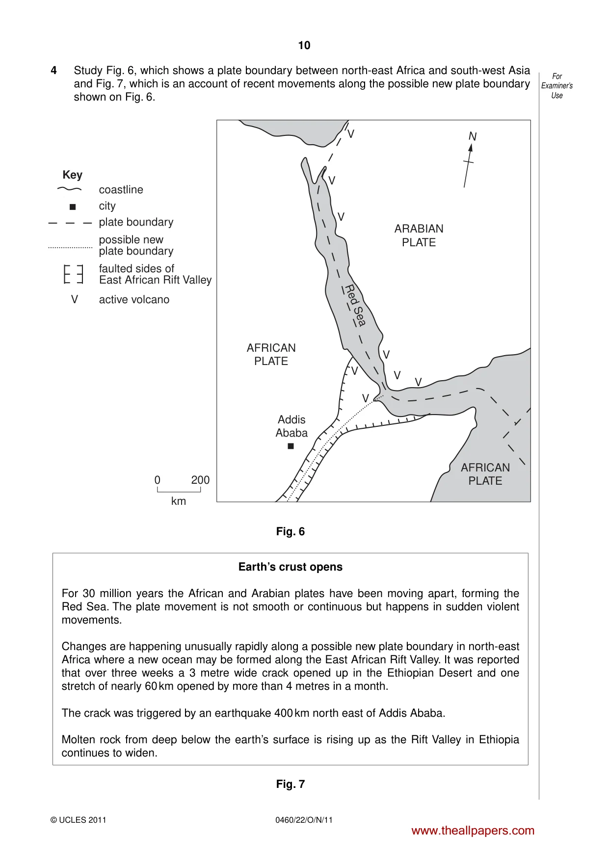
10 For Examiner’s Use 0460/22/O/N/11 © UCLES 2011 4 Study Fig. 6, which shows a plate boundary between north-east Africa and south-west Asia and Fig. 7, which is an account of recent movements along the possible new plate boundary shown on Fig. 6. V V V V V V V V V 0 200 km coastline city plate boundary Key possible new plate boundary faulted sides of East African Rift Valley active volcano N ARABIAN PLATE Red Sea AFRICAN PLATE AFRICAN PLATE Addis Ababa Fig. 6 Earth’s crust opens For 30 million years the African and Arabian plates have been moving apart, forming the Red Sea. The plate movement is not smooth or continuous but happens in sudden violent movements. Changes are happening unusually rapidly along a possible new plate boundary in north-east Africa where a new ocean may be formed along the East African Rift Valley. It was reported that over three weeks a 3 metre wide crack opened up in the Ethiopian Desert and one stretch of nearly 60 km opened by more than 4 metres in a month. The crack was triggered by an earthquake 400 km north east of Addis Ababa. Molten rock from deep below the earth’s surface is rising up as the Rift Valley in Ethiopia continues to widen. Fig. 7 www.theallpapers.com
Question paper, page 11
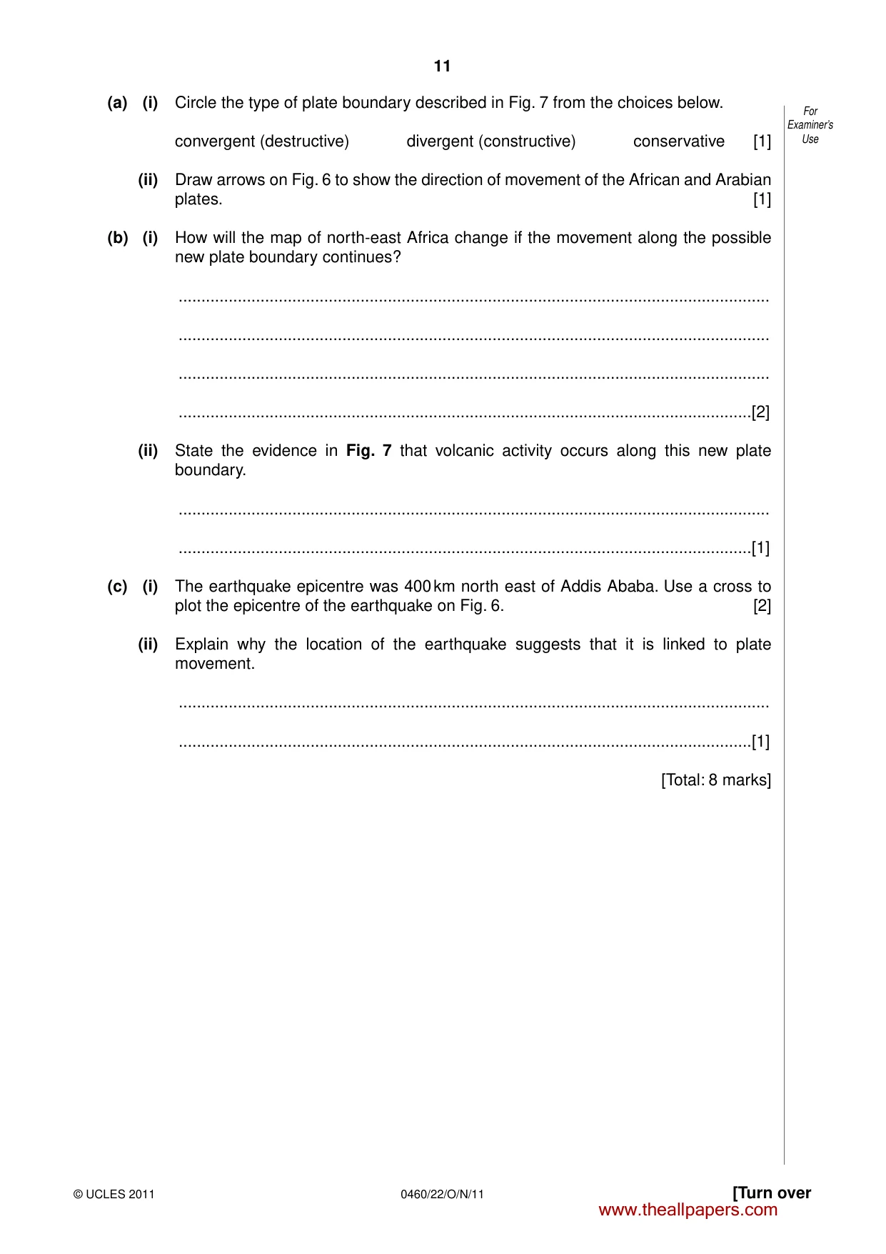
11 [Turn over For Examiner’s Use © UCLES 2011 0460/22/O/N/11 (a) (i) Circle the type of plate boundary described in Fig. 7 from the choices below. convergent (destructive) divergent (constructive) conservative [1] (ii) Draw arrows on Fig. 6 to show the direction of movement of the African and Arabian plates. [1] (b) (i) How will the map of north-east Africa change if the movement along the possible new plate boundary continues? … … … …[2] (ii) State the evidence in Fig. 7 that volcanic activity occurs along this new plate boundary. … …[1] (c) (i) The earthquake epicentre was 400 km north east of Addis Ababa. Use a cross to plot the epicentre of the earthquake on Fig. 6. [2] (ii) Explain why the location of the earthquake suggests that it is linked to plate movement. … …[1] [Total: 8 marks] www.theallpapers.com
Question paper, page 12
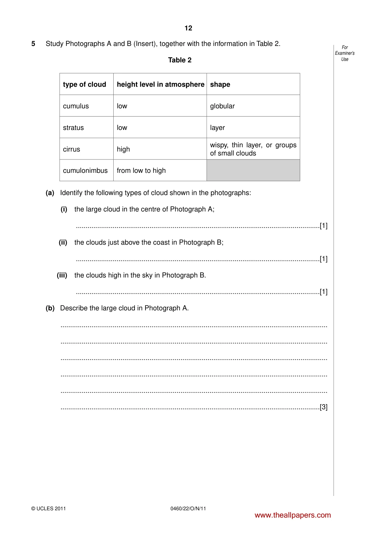
12 For Examiner’s Use 0460/22/O/N/11 © UCLES 2011 5 Study Photographs A and B (Insert), together with the information in Table 2. Table 2 type of cloud height level in atmosphere shape cumulus low globular stratus low layer cirrus high wispy, thin layer, or groups of small clouds cumulonimbus from low to high (a) Identify the following types of cloud shown in the photographs: (i) the large cloud in the centre of Photograph A; …[1] (ii) the clouds just above the coast in Photograph B; …[1] (iii) the clouds high in the sky in Photograph B. …[1] (b) Describe the large cloud in Photograph A. … … … … … …[3] www.theallpapers.com
Question paper, page 13
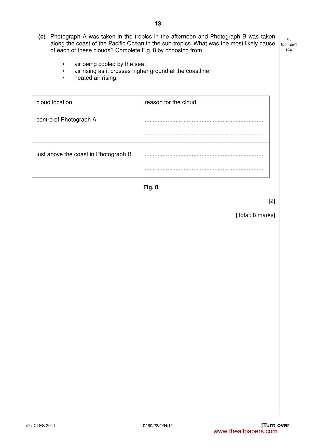
13 [Turn over For Examiner’s Use © UCLES 2011 0460/22/O/N/11 (c) Photograph A was taken in the tropics in the afternoon and Photograph B was taken along the coast of the Pacific Ocean in the sub-tropics. What was the most likely cause of each of these clouds? Complete Fig. 8 by choosing from: • air being cooled by the sea; • air rising as it crosses higher ground at the coastline; • heated air rising. cloud location reason for the cloud centre of Photograph A … … just above the coast in Photograph B … … Fig. 8 [2] [Total: 8 marks] www.theallpapers.com
Question paper, page 14
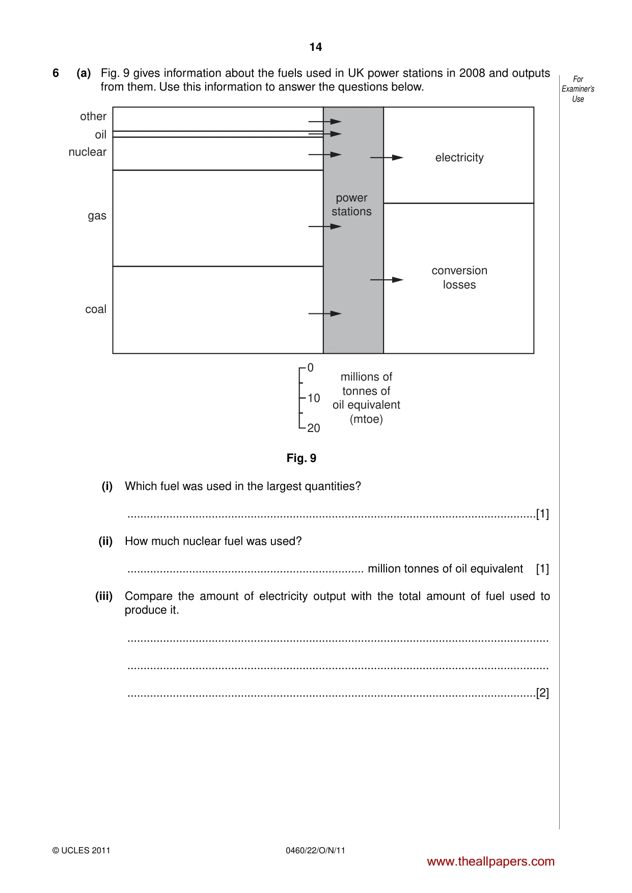
14 For Examiner’s Use 0460/22/O/N/11 © UCLES 2011 6 (a) Fig. 9 gives information about the fuels used in UK power stations in 2008 and outputs from them. Use this information to answer the questions below. power stations electricity conversion losses gas nuclear oil other coal 0 10 20 millions of tonnes of oil equivalent (mtoe) Fig. 9 (i) Which fuel was used in the largest quantities? …[1] (ii) How much nuclear fuel was used? … million tonnes of oil equivalent [1] (iii) Compare the amount of electricity output with the total amount of fuel used to produce it. … … …[2] www.theallpapers.com
Question paper, page 15
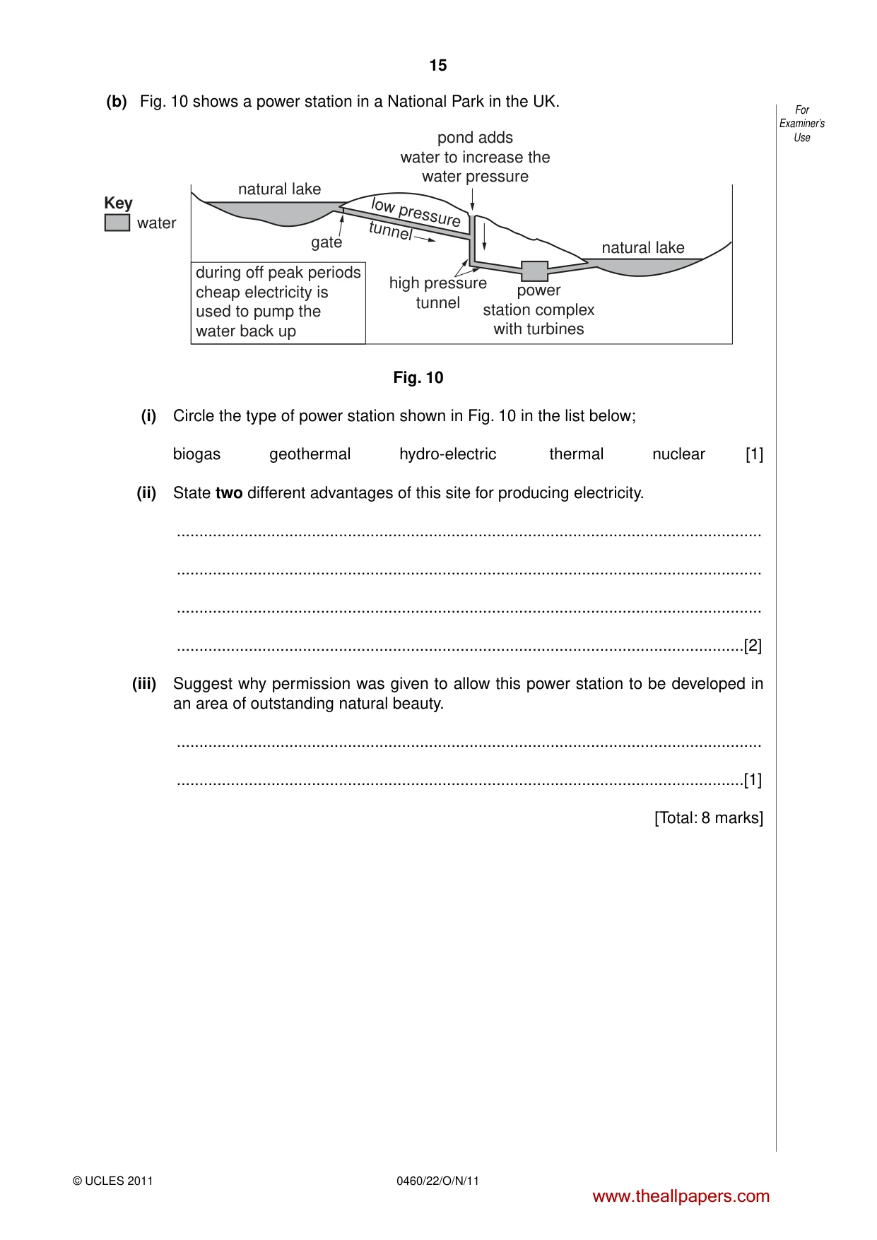
15 For Examiner’s Use © UCLES 2011 0460/22/O/N/11 (b) Fig. 10 shows a power station in a National Park in the UK. low pressure tunnel gate natural lake water Key natural lake pond adds water to increase the water pressure high pressure tunnel during off peak periods cheap electricity is used to pump the water back up power station complex with turbines Fig. 10 (i) Circle the type of power station shown in Fig. 10 in the list below; biogas geothermal hydro-electric thermal nuclear [1] (ii) State two different advantages of this site for producing electricity. … … … …[2] (iii) Suggest why permission was given to allow this power station to be developed in an area of outstanding natural beauty. … …[1] [Total: 8 marks] www.theallpapers.com
Question paper, page 16
16 0460/22/O/N/11 © UCLES 2011 BLANK PAGE Copyright Acknowledgements: Question 1 © Map of Medine, Mauritius, Mauritius Government. Question 5 Photographs A and B Muriel Fretwell © UCLES Question 6 Fig. 10 © http://www.reuk.co.uk/UK-Hydro-Power-Stations.htm; 3 August 2010 Permission to reproduce items where third-party owned material protected by copyright is included has been sought and cleared where possible. Every reasonable effort has been made by the publisher (UCLES) to trace copyright holders, but if any items requiring clearance have unwittingly been included, the publisher will be pleased to make amends at the earliest possible opportunity. University of Cambridge International Examinations is part of the Cambridge Assessment Group. Cambridge Assessment is the brand name of University of Cambridge Local Examinations Syndicate (UCLES), which is itself a department of the University of Cambridge. www.theallpapers.com
Mark scheme, page 1
UNIVERSITY OF CAMBRIDGE INTERNATIONAL EXAMINATIONS International General Certificate of Secondary Education MARK SCHEME for the October/November 2011 question paper for the guidance of teachers 0460 GEOGRAPHY 0460/22 Paper 2, maximum raw mark 60 This mark scheme is published as an aid to teachers and candidates, to indicate the requirements of the examination. It shows the basis on which Examiners were instructed to award marks. It does not indicate the details of the discussions that took place at an Examiners’ meeting before marking began, which would have considered the acceptability of alternative answers. Mark schemes must be read in conjunction with the question papers and the report on the examination. • Cambridge will not enter into discussions or correspondence in connection with these mark schemes. Cambridge is publishing the mark schemes for the October/November 2011 question papers for most IGCSE, GCE Advanced Level and Advanced Subsidiary Level syllabuses and some Ordinary Level syllabuses. www.theallpapers.com
Mark scheme, page 2
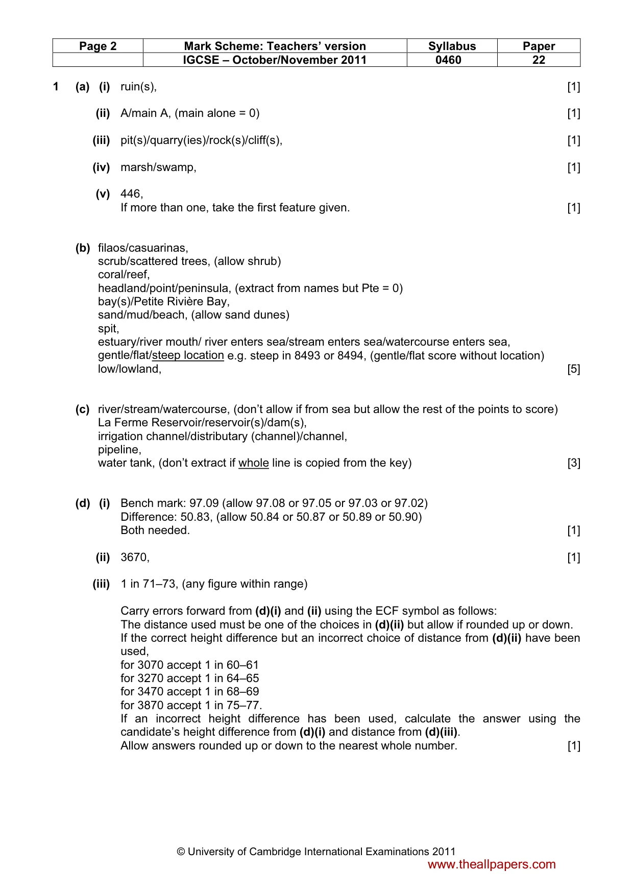
Page 2 Mark Scheme: Teachers’ version Syllabus Paper IGCSE – October/November 2011 0460 22 © University of Cambridge International Examinations 2011 1 (a) (i) ruin(s), [1] (ii) A/main A, (main alone = 0) [1] (iii) pit(s)/quarry(ies)/rock(s)/cliff(s), [1] (iv) marsh/swamp, [1] (v) 446, If more than one, take the first feature given. [1] (b) filaos/casuarinas, scrub/scattered trees, (allow shrub) coral/reef, headland/point/peninsula, (extract from names but Pte = 0) bay(s)/Petite Rivière Bay, sand/mud/beach, (allow sand dunes) spit, estuary/river mouth/ river enters sea/stream enters sea/watercourse enters sea, gentle/flat/steep location e.g. steep in 8493 or 8494, (gentle/flat score without location) low/lowland, [5] (c) river/stream/watercourse, (don’t allow if from sea but allow the rest of the points to score) La Ferme Reservoir/reservoir(s)/dam(s), irrigation channel/distributary (channel)/channel, pipeline, water tank, (don’t extract if whole line is copied from the key) [3] (d) (i) Bench mark: 97.09 (allow 97.08 or 97.05 or 97.03 or 97.02) Difference: 50.83, (allow 50.84 or 50.87 or 50.89 or 50.90) Both needed. [1] (ii) 3670, [1] (iii) 1 in 71–73, (any figure within range) Carry errors forward from (d)(i) and (ii) using the ECF symbol as follows: The distance used must be one of the choices in (d)(ii) but allow if rounded up or down. If the correct height difference but an incorrect choice of distance from (d)(ii) have been used, for 3070 accept 1 in 60–61 for 3270 accept 1 in 64–65 for 3470 accept 1 in 68–69 for 3870 accept 1 in 75–77. If an incorrect height difference has been used, calculate the answer using the candidate’s height difference from (d)(i) and distance from (d)(iii). Allow answers rounded up or down to the nearest whole number. [1] www.theallpapers.com
Mark scheme, page 3
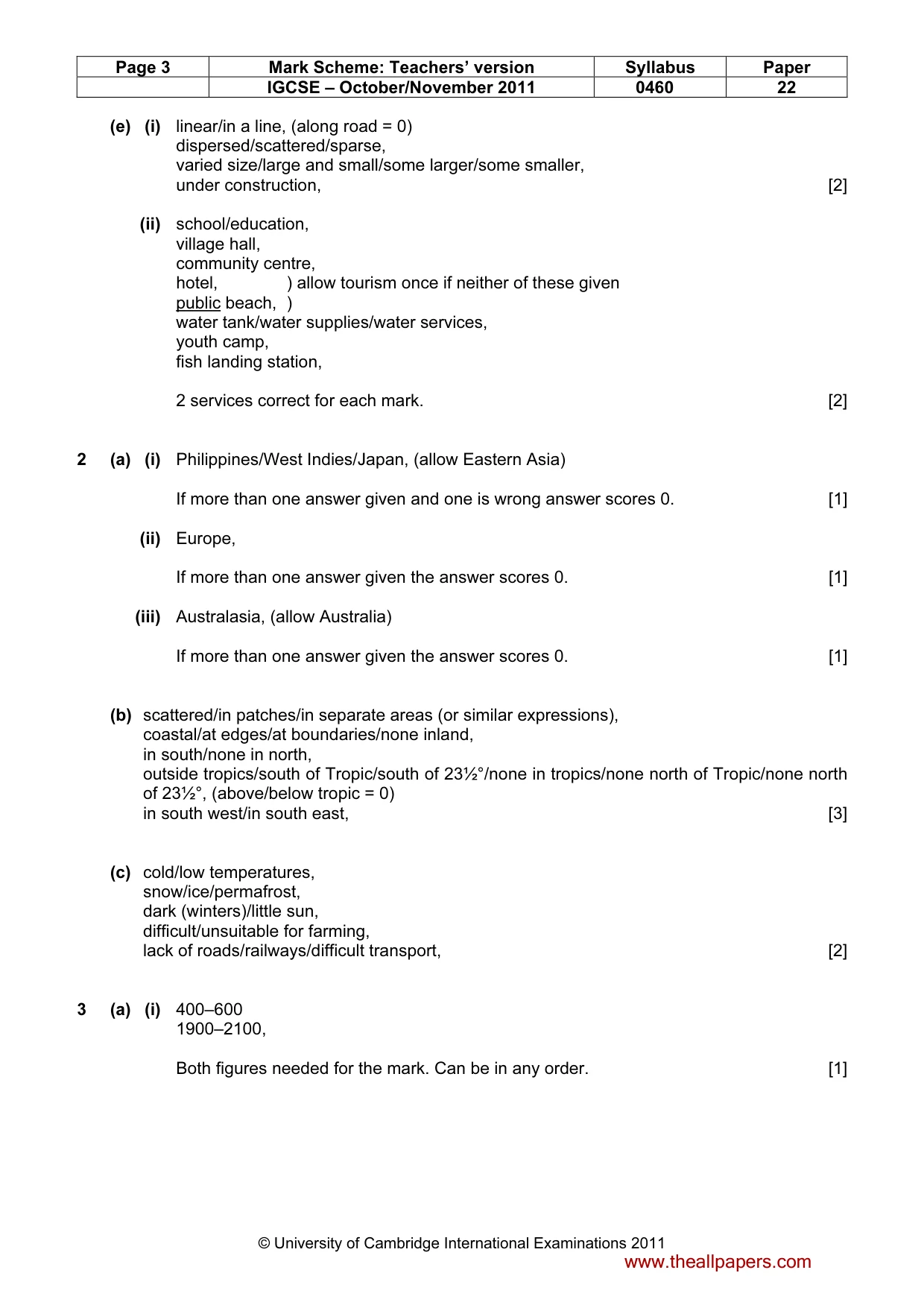
Page 3 Mark Scheme: Teachers’ version Syllabus Paper IGCSE – October/November 2011 0460 22 © University of Cambridge International Examinations 2011 (e) (i) linear/in a line, (along road = 0) dispersed/scattered/sparse, varied size/large and small/some larger/some smaller, under construction, [2] (ii) school/education, village hall, community centre, hotel, ) allow tourism once if neither of these given public beach, ) water tank/water supplies/water services, youth camp, fish landing station, 2 services correct for each mark. [2] 2 (a) (i) Philippines/West Indies/Japan, (allow Eastern Asia) If more than one answer given and one is wrong answer scores 0. [1] (ii) Europe, If more than one answer given the answer scores 0. [1] (iii) Australasia, (allow Australia) If more than one answer given the answer scores 0. [1] (b) scattered/in patches/in separate areas (or similar expressions), coastal/at edges/at boundaries/none inland, in south/none in north, outside tropics/south of Tropic/south of 23½°/none in tropics/none north of Tropic/none north of 23½°, (above/below tropic = 0) in south west/in south east, [3] (c) cold/low temperatures, snow/ice/permafrost, dark (winters)/little sun, difficult/unsuitable for farming, lack of roads/railways/difficult transport, [2] 3 (a) (i) 400–600 1900–2100, Both figures needed for the mark. Can be in any order. [1] www.theallpapers.com
Mark scheme, page 4
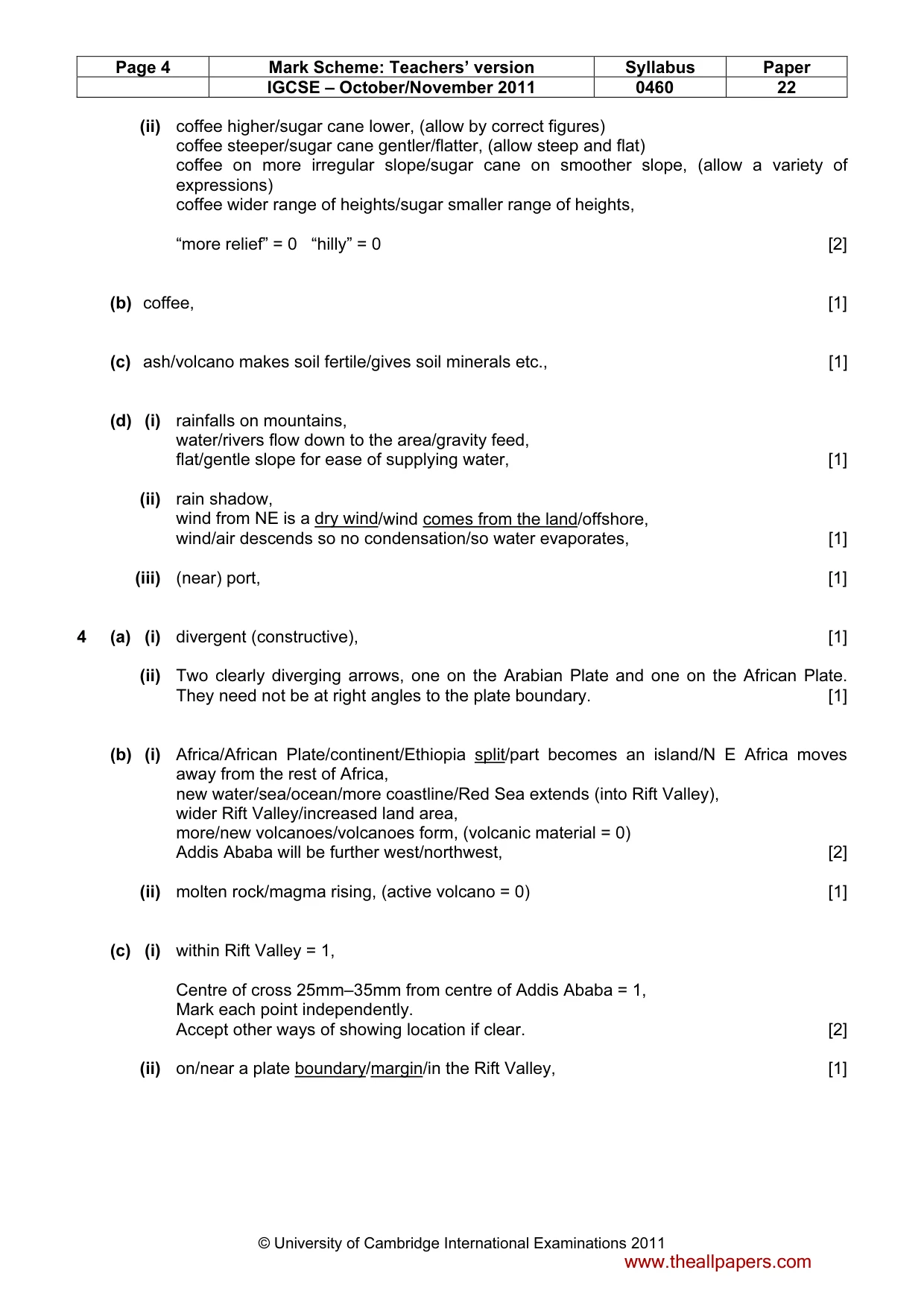
Page 4 Mark Scheme: Teachers’ version Syllabus Paper IGCSE – October/November 2011 0460 22 © University of Cambridge International Examinations 2011 (ii) coffee higher/sugar cane lower, (allow by correct figures) coffee steeper/sugar cane gentler/flatter, (allow steep and flat) coffee on more irregular slope/sugar cane on smoother slope, (allow a variety of expressions) coffee wider range of heights/sugar smaller range of heights, “more relief” = 0 “hilly” = 0 [2] (b) coffee, [1] (c) ash/volcano makes soil fertile/gives soil minerals etc., [1] (d) (i) rainfalls on mountains, water/rivers flow down to the area/gravity feed, flat/gentle slope for ease of supplying water, [1] (ii) rain shadow, wind from NE is a dry wind/wind comes from the land/offshore, wind/air descends so no condensation/so water evaporates, [1] (iii) (near) port, [1] 4 (a) (i) divergent (constructive), [1] (ii) Two clearly diverging arrows, one on the Arabian Plate and one on the African Plate. They need not be at right angles to the plate boundary. [1] (b) (i) Africa/African Plate/continent/Ethiopia split/part becomes an island/N E Africa moves away from the rest of Africa, new water/sea/ocean/more coastline/Red Sea extends (into Rift Valley), wider Rift Valley/increased land area, more/new volcanoes/volcanoes form, (volcanic material = 0) Addis Ababa will be further west/northwest, [2] (ii) molten rock/magma rising, (active volcano = 0) [1] (c) (i) within Rift Valley = 1, Centre of cross 25mm–35mm from centre of Addis Ababa = 1, Mark each point independently. Accept other ways of showing location if clear. [2] (ii) on/near a plate boundary/margin/in the Rift Valley, [1] www.theallpapers.com
Mark scheme, page 5
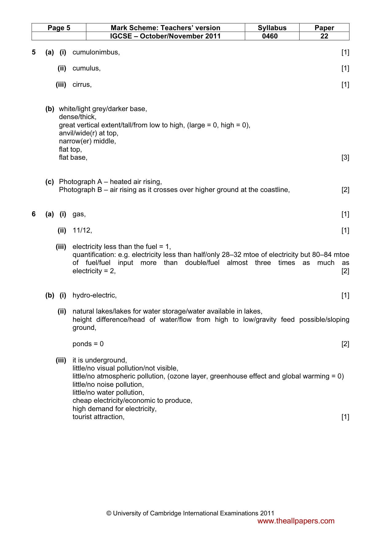
Page 5 Mark Scheme: Teachers’ version Syllabus Paper IGCSE – October/November 2011 0460 22 © University of Cambridge International Examinations 2011 5 (a) (i) cumulonimbus, [1] (ii) cumulus, [1] (iii) cirrus, [1] (b) white/light grey/darker base, dense/thick, great vertical extent/tall/from low to high, (large = 0, high = 0), anvil/wide(r) at top, narrow(er) middle, flat top, flat base, [3] (c) Photograph A – heated air rising, Photograph B – air rising as it crosses over higher ground at the coastline, [2] 6 (a) (i) gas, [1] (ii) 11/12, [1] (iii) electricity less than the fuel = 1, quantification: e.g. electricity less than half/only 28–32 mtoe of electricity but 80–84 mtoe of fuel/fuel input more than double/fuel almost three times as much as electricity = 2, [2] (b) (i) hydro-electric, [1] (ii) natural lakes/lakes for water storage/water available in lakes, height difference/head of water/flow from high to low/gravity feed possible/sloping ground, ponds = 0 [2] (iii) it is underground, little/no visual pollution/not visible, little/no atmospheric pollution, (ozone layer, greenhouse effect and global warming = 0) little/no noise pollution, little/no water pollution, cheap electricity/economic to produce, high demand for electricity, tourist attraction, [1] www.theallpapers.com
What you needed in this session
Cambridge’s own grade thresholds for 2011 Oct/Nov, Paper 2 · Variant 2. A higher threshold means an easier paper — the bar moves with how the cohort did.