Cambridge IGCSE Environmental Management 0680 — 2025 Oct/Nov Paper 2 · Variant 2
0680/22/O/N/25 · 4 questions · 80 marks · 105 min
The question paper and its mark scheme, free to read here and free to download. This is Cambridge’s own paper, exactly as it was sat.
Question paper20 pages
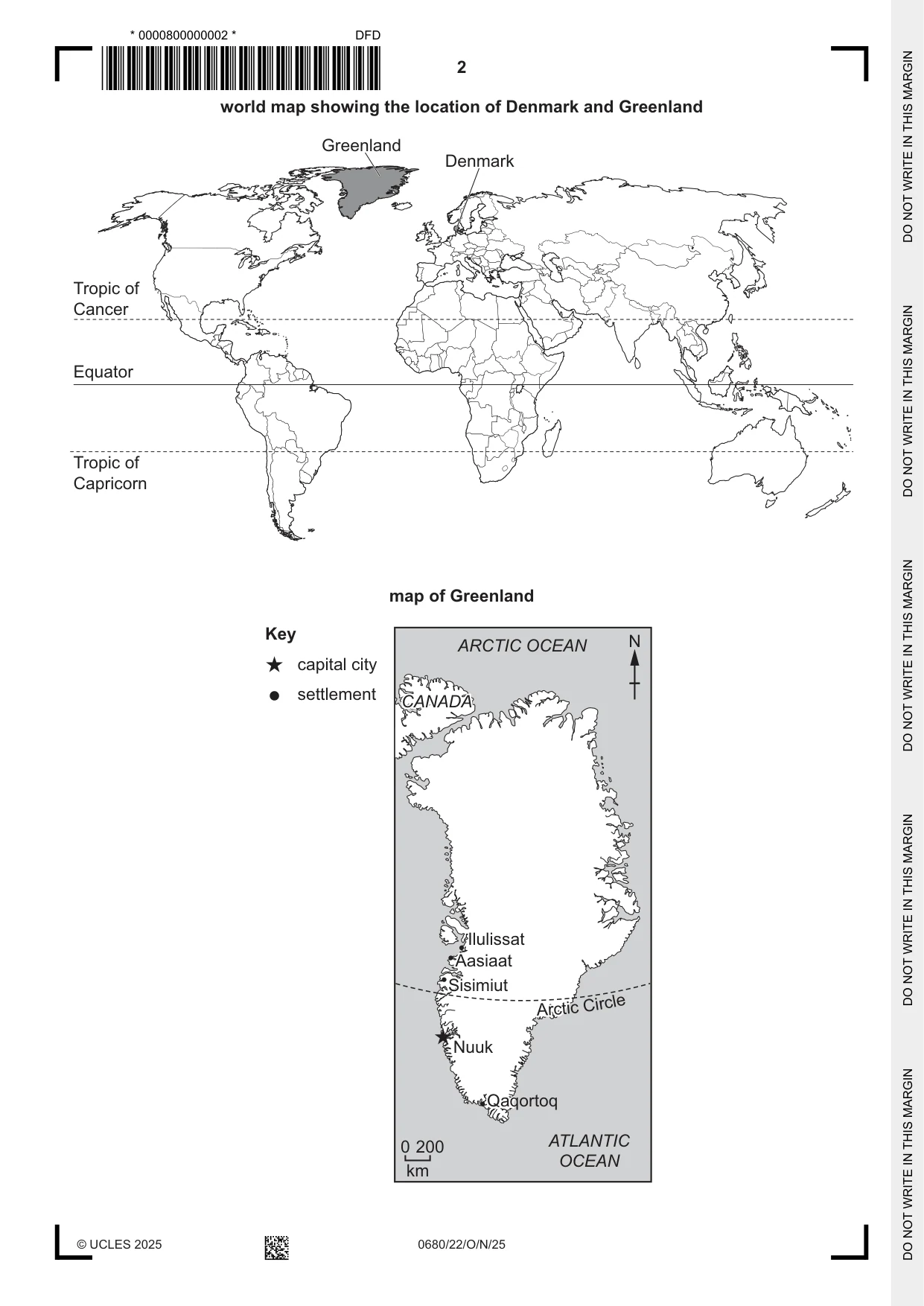
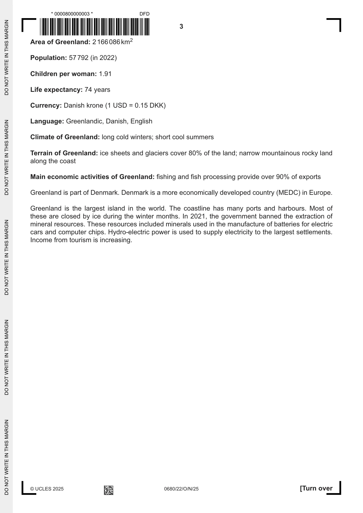
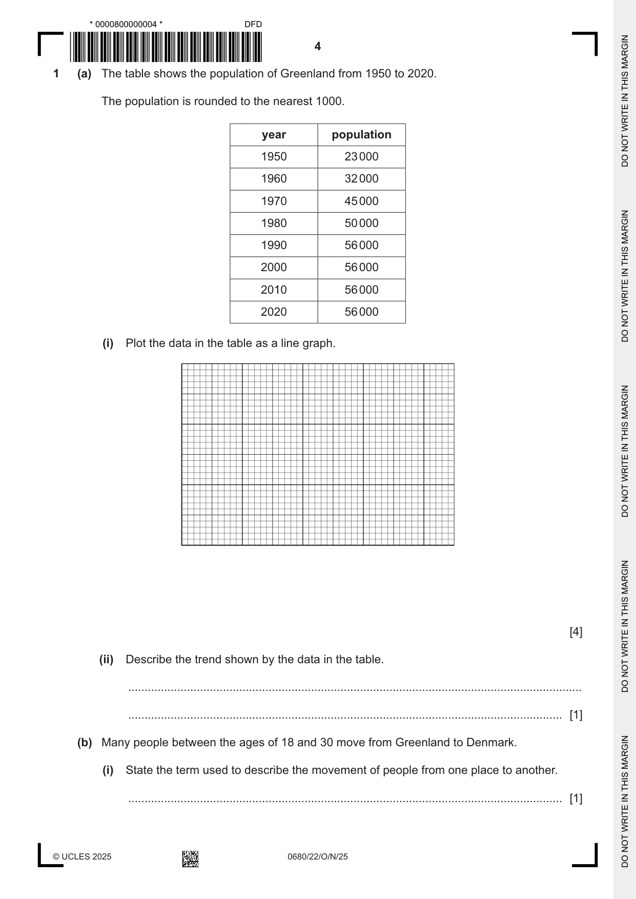


Mark scheme17 pages
Answers below. Sit the paper first if you are practising.
Questions as text
Q1 · The table shows the population of Greenland from 1950 to 2020
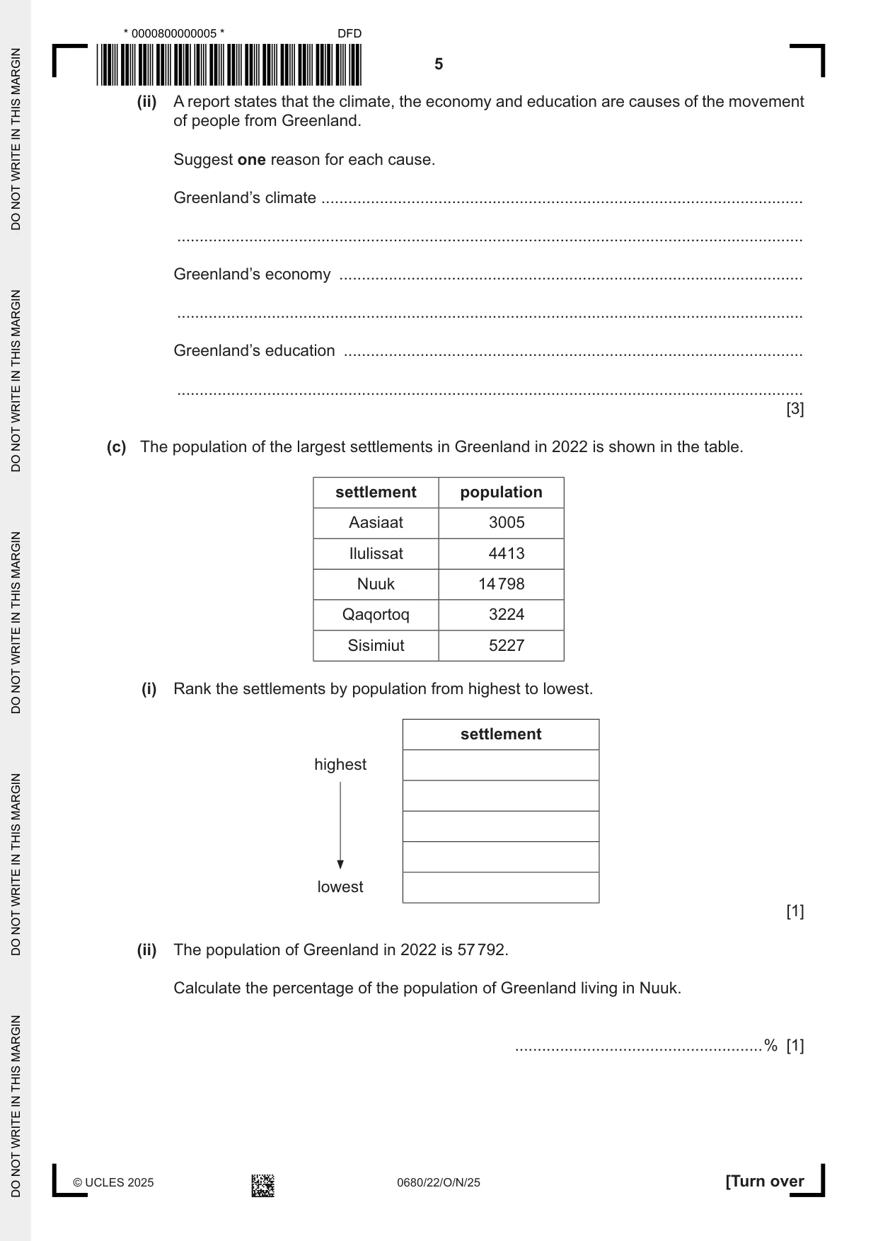
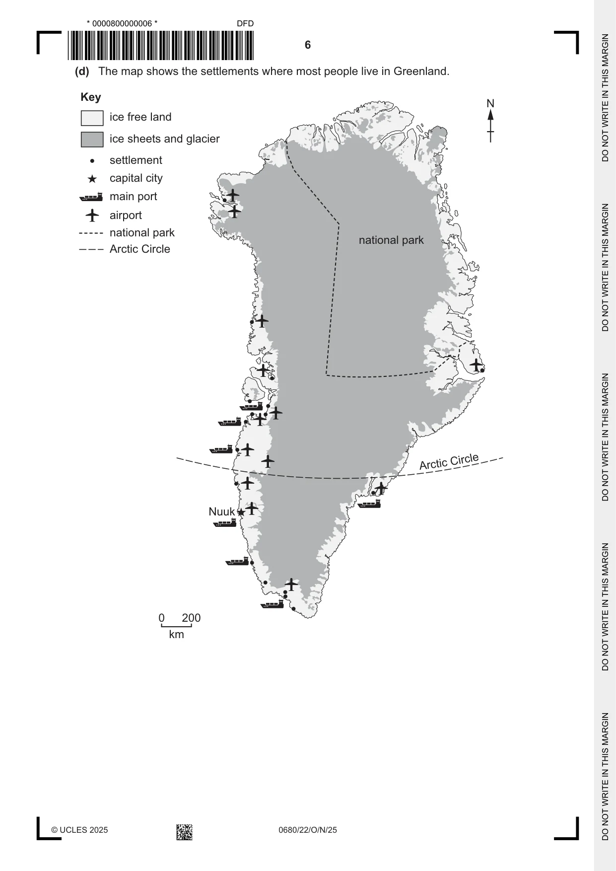
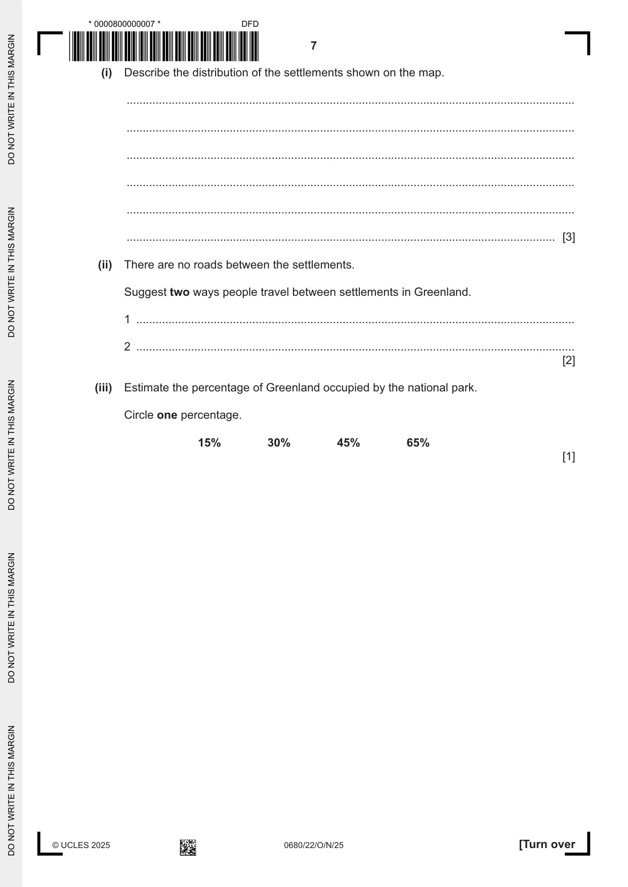
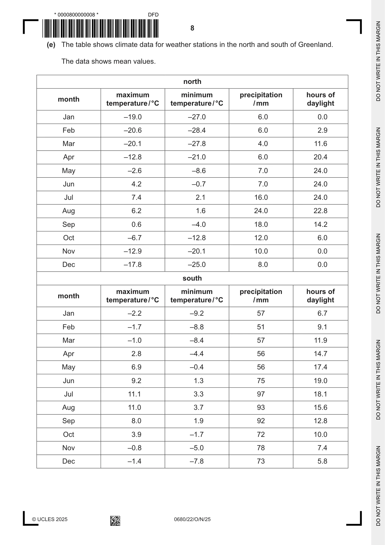
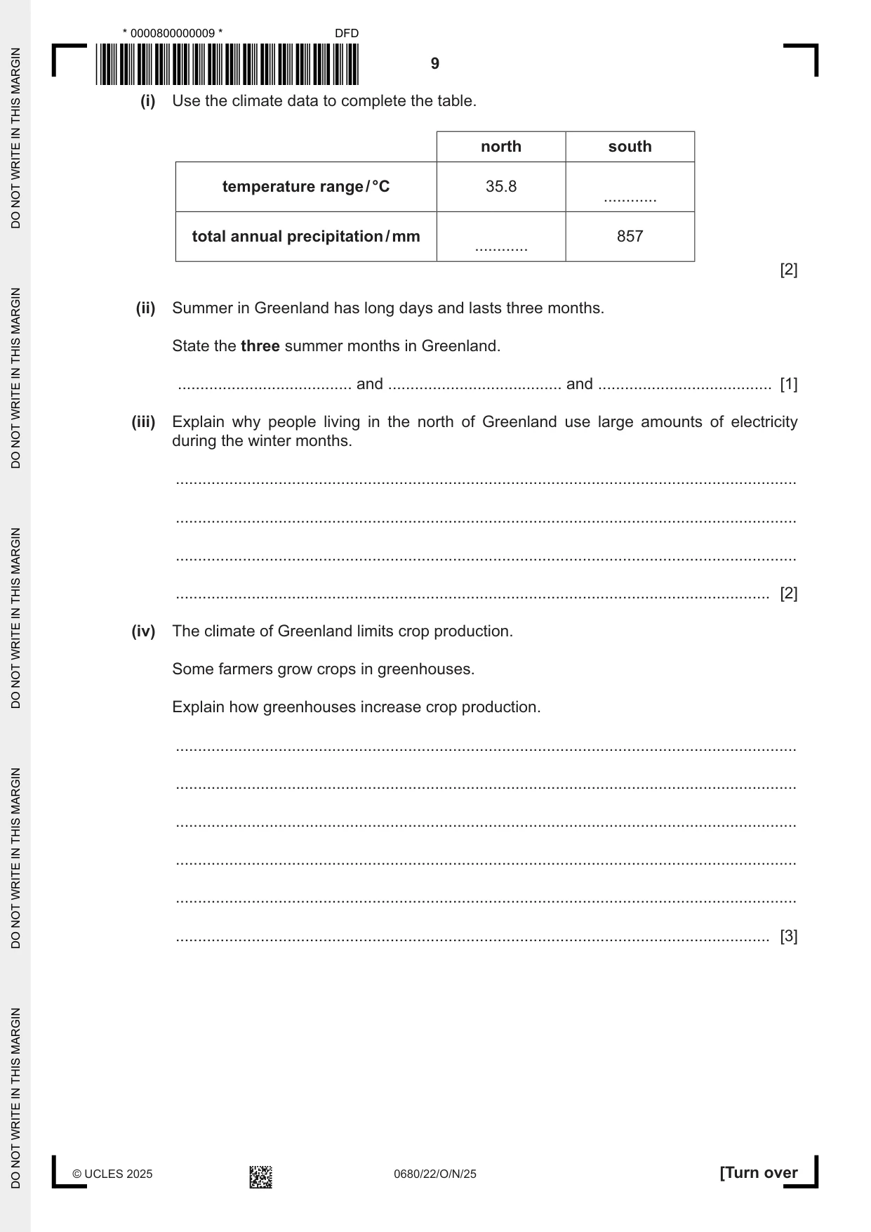
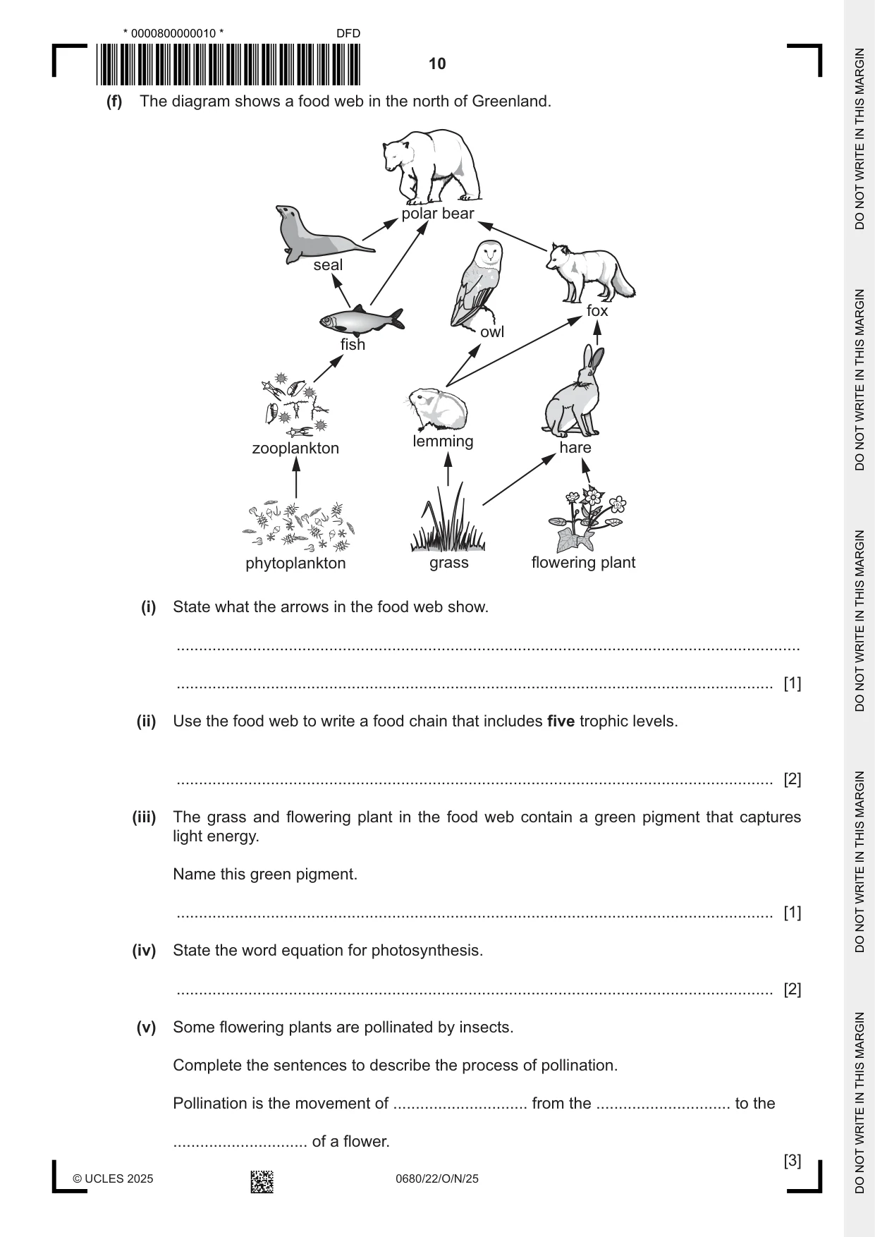
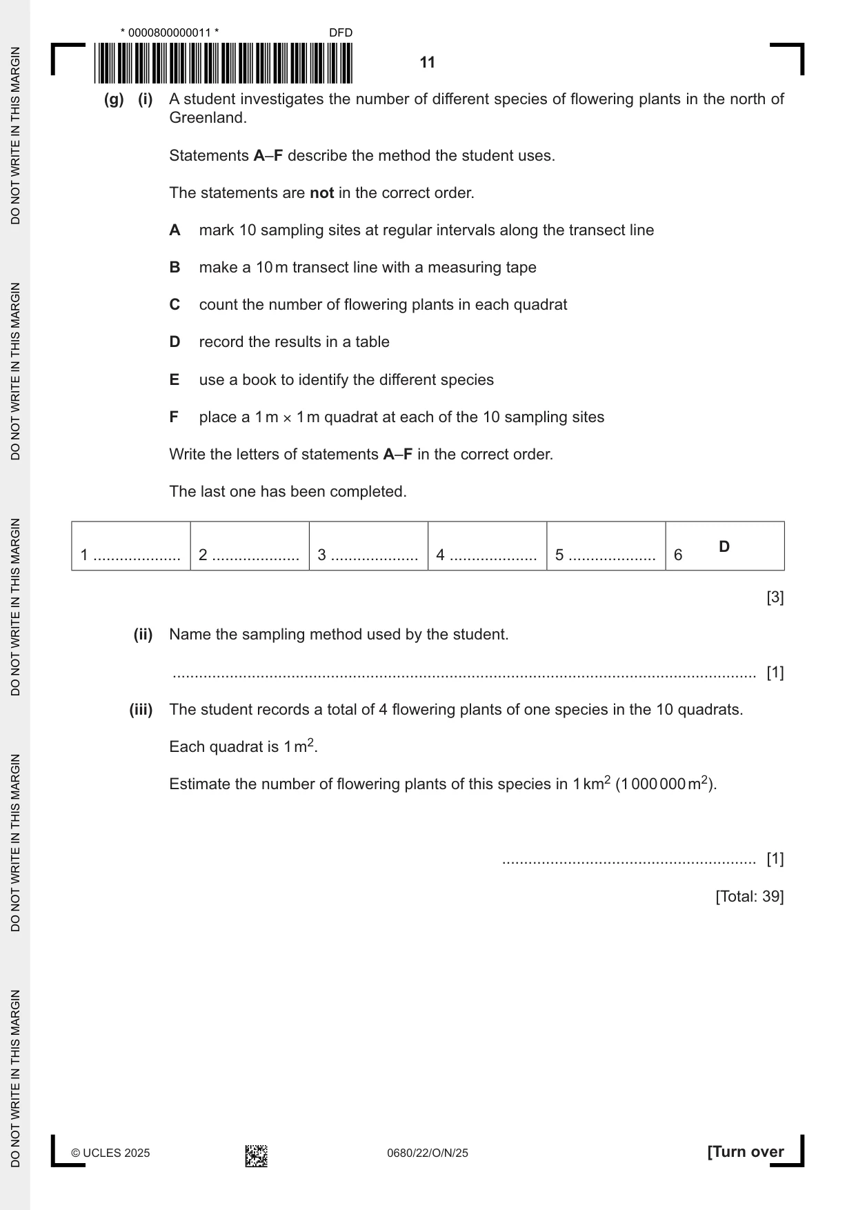
1 (a) The table shows the population of Greenland from 1950 to 2020. The population is rounded to the nearest 1000. year population 1950 23 000 1960 32 000 1970 45 000 1980 50 000 1990 56 000 2000 56 000 2010 56 000 2020 56 000 (i) Plot the data in the table as a line graph. [4] (ii) Describe the trend shown by the data in the table. ........................................................................................................................................... ..................................................................................................................................... [1] (b) Many people between the ages of 18 and 30 move from Greenland to Denmark. (i) State the term used to describe the movement of people from one place to another. ..................................................................................................................................... [1] (ii) A report states that the climate, the economy and education are causes of the movement of people from Greenland. Suggest one reason for each cause. Greenland’s climate ........................................................................................................... ........................................................................................................................................... Greenland’s economy ....................................................................................................... ........................................................................................................................................... Greenland’s education ...................................................................................................... ........................................................................................................................................... [3] (c) The population of the largest settlements in Greenland in 2022 is shown in the table. settlement population Aasiaat 3005 Ilulissat 4413 Nuuk 14 798 Qaqortoq 3224 Sisimiut 5227 (i) Rank the settlements by population from highest to lowest. settlement highest lowest [1] (ii) The population of Greenland in 2022 is 57 792. Calculate the percentage of the population of Greenland living in Nuuk. .......................................................% [1] (d) The map shows the settlements where most people live in Greenland. Key N ice free land ice sheets and glacier settlement capital city main port airport national park national park Arctic Circle Circle Arctic Nuuk 0 200 km (i) Describe the distribution of the settlements shown on the map. ........................................................................................................................................... ........................................................................................................................................... ........................................................................................................................................... ........................................................................................................................................... ........................................................................................................................................... ..................................................................................................................................... [3] (ii) There are no roads between the settlements. Suggest two ways people travel between settlements in Greenland. 1 ........................................................................................................................................ 2 ........................................................................................................................................ [2] (iii) Estimate the percentage of Greenland occupied by the national park. Circle one percentage. 15% 30% 45% 65% [1] (e) The table shows climate data for weather stations in the north and south of Greenland. The data shows mean values. north maximum minimum precipitation hours of month temperature / °C temperature / °C / mm daylight Jan –19.0 –27.0 6.0 0.0 Feb –20.6 –28.4 6.0 2.9 Mar –20.1 –27.8 4.0 11.6 Apr –12.8 –21.0 6.0 20.4 May –2.6 –8.6 7.0 24.0 Jun 4.2 –0.7 7.0 24.0 Jul 7.4 2.1 16.0 24.0 Aug 6.2 1.6 24.0 22.8 Sep 0.6 –4.0 18.0 14.2 Oct –6.7 –12.8 12.0 6.0 Nov –12.9 –20.1 10.0 0.0 Dec –17.8 –25.0 8.0 0.0 south maximum minimum precipitation hours of month temperature / °C temperature / °C / mm daylight Jan –2.2 –9.2 57 6.7 Feb –1.7 –8.8 51 9.1 Mar –1.0 –8.4 57 11.9 Apr 2.8 –4.4 56 14.7 May 6.9 –0.4 56 17.4 Jun 9.2 1.3 75 19.0 Jul 11.1 3.3 97 18.1 Aug 11.0 3.7 93 15.6 Sep 8.0 1.9 92 12.8 Oct 3.9 –1.7 72 10.0 Nov –0.8 –5.0 78 7.4 Dec –1.4 –7.8 73 5.8 (i) Use the climate data to complete the table. north south temperature range / °C 35.8 ............ total annual precipitation / mm 857 ............ [2] (ii) Summer in Greenland has long days and lasts three months. State the three summer months in Greenland. ....................................... and ....................................... and ....................................... [1] (iii) Explain why people living in the north of Greenland use large amounts of electricity during the winter months. ........................................................................................................................................... ........................................................................................................................................... ........................................................................................................................................... ..................................................................................................................................... [2] (iv) The climate of Greenland limits crop production. Some farmers grow crops in greenhouses. Explain how greenhouses increase crop production. ........................................................................................................................................... ........................................................................................................................................... ........................................................................................................................................... ........................................................................................................................................... ........................................................................................................................................... ..................................................................................................................................... [3] (f) The diagram shows a food web in the north of Greenland. polar bear seal fox owl fish lemming zooplankton hare phytoplankton grass flowering plant (i) State what the arrows in the food web show. ........................................................................................................................................... ..................................................................................................................................... [1] (ii) Use the food web to write a food chain that includes five trophic levels. ..................................................................................................................................... [2] (iii) The grass and flowering plant in the food web contain a green pigment that captures light energy. Name this green pigment. ..................................................................................................................................... [1] (iv) State the word equation for photosynthesis. ..................................................................................................................................... [2] (v) Some flowering plants are pollinated by insects. Complete the sentences to describe the process of pollination. Pollination is the movement of .............................. from the .............................. to the .............................. of a flower. [3] (g) (i) A student investigates the number of different species of flowering plants in the north of Greenland. Statements A–F describe the method the student uses. The statements are not in the correct order. A mark 10 sampling sites at regular intervals along the transect line B make a 10 m transect line with a measuring tape C count the number of flowering plants in each quadrat D record the results in a table E use a book to identify the different species F place a 1 m × 1 m quadrat at each of the 10 sampling sites Write the letters of statements A–F in the correct order. The last one has been completed. D 1 .................... 2 .................... 3 .................... 4 .................... 5 .................... 6 [3] (ii) Name the sampling method used by the student. ..................................................................................................................................... [1] (iii) The student records a total of 4 flowering plants of one species in the 10 quadrats. Each quadrat is 1 m2. Estimate the number of flowering plants of this species in 1 km2 (1 000 000 m2). .......................................................... [1] [Total: 39]
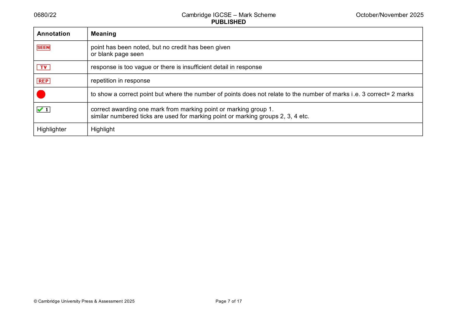
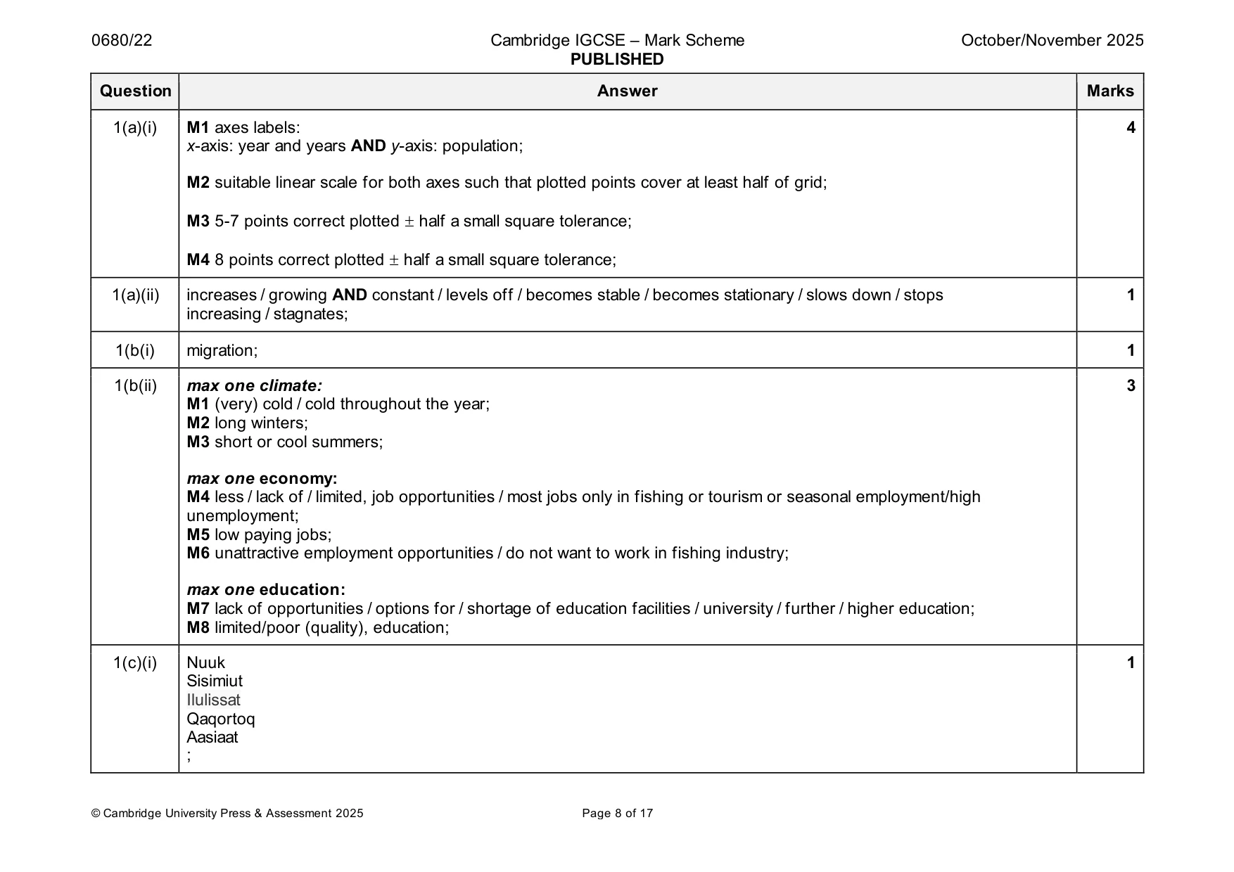
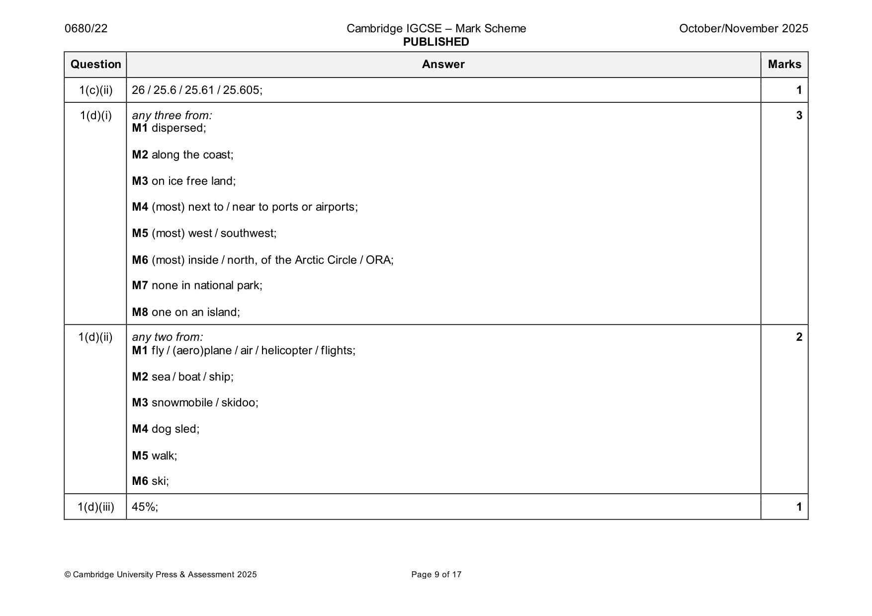
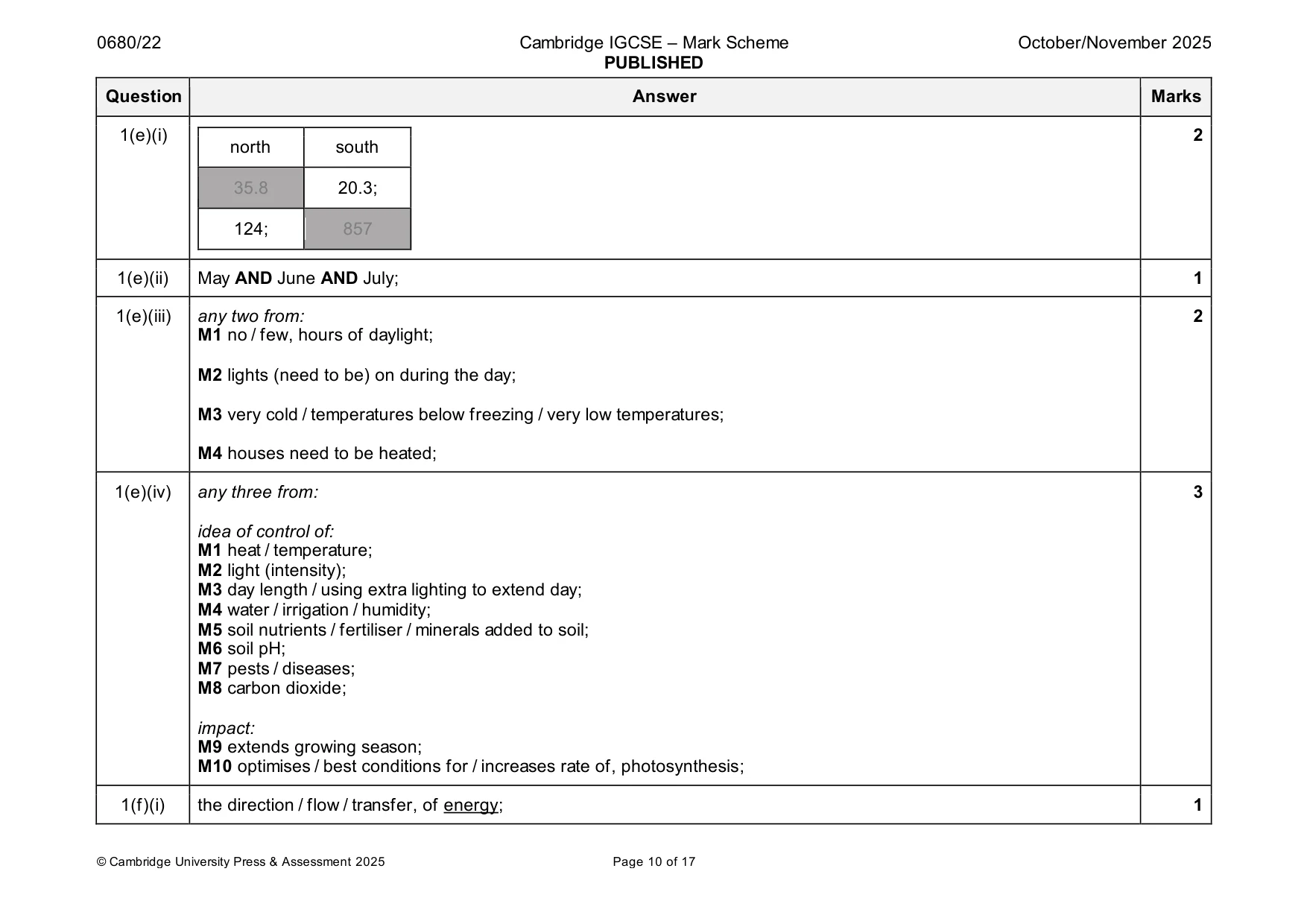
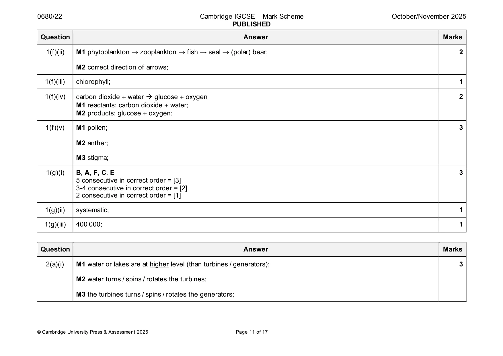
Mark scheme: Question Answer Marks 1(a)(i) M1 axes labels: 4 x-axis: year and years AND y-axis: population; M2 suitable linear scale for both axes such that plotted points cover at least half of grid; M3 5-7 points correct plotted half a small square tolerance; M4 8 points correct plotted half a small square tolerance; 1(a)(ii) increases / growing AND constant / levels off / becomes stable / becomes stationary / slows down / stops 1 increasing / stagnates; 1(b(i) migration; 1 1(b(ii) max one climate: 3 M1 (very) cold / cold throughout the year; M2 long winters; M3 short or cool summers; max one economy: M4 less / lack of / limited, job opportunities / most jobs only in fishing or tourism or seasonal employment/high unemployment; M5 low paying jobs; M6 unattractive employment opportunities / do not want to work in fishing industry; max one education: M7 lack of opportunities / options for / shortage of education facilities / university / further / higher education; M8 limited/poor (quality), education; 1(c)(i) Nuuk 1 Sisimiut Ilulissat Qaqortoq Aasiaat ; 1(c)(ii) 26 / 25.6 / 25.61 / 25.605; 1 1(d)(i) any three from: 3 M1 dispersed; M2 along the coast; M3 on ice free land; M4 (most) next to / near to ports or airports; M5 (most) west / southwest; M6 (most) inside / north, of the Arctic Circle / ORA; M7 none in national park; M8 one on an island; 1(d)(ii) any two from: 2 M1 fly / (aero)plane / air / helicopter / flights; M2 sea / boat / ship; M3 snowmobile / skidoo; M4 dog sled; M5 walk; M6 ski; 1(d)(iii) 45%; 1 1(e)(i) 2 north south 35.8 20.3; 124; 857 1(e)(ii) May AND June AND July; 1 1(e)(iii) any two from: 2 M1 no / few, hours of daylight; M2 lights (need to be) on during the day; M3 very cold / temperatures below freezing / very low temperatures; M4 houses need to be heated; 1(e)(iv) any three from: 3 idea of control of: M1 heat / temperature; M2 light (intensity); M3 day length / using extra lighting to extend day; M4 water / irrigation / humidity; M5 soil nutrients / fertiliser / minerals added to soil; M6 soil pH; M7 pests / diseases; M8 carbon dioxide; impact: M9 extends growing season; M10 optimises / best conditions for / increases rate of, photosynthesis; 1(f)(i) the direction / flow / transfer, of energy; 1 1(f)(ii) M1 phytoplankton → zooplankton → fish → seal → (polar) bear; 2 M2 correct direction of arrows; 1(f)(iii) chlorophyll; 1 1(f)(iv) carbon dioxide + water → glucose + oxygen 2 M1 reactants: carbon dioxide + water; M2 products: glucose + oxygen; 1(f)(v) M1 pollen; 3 M2 anther; M3 stigma; 1(g)(i) B, A, F, C, E 3 5 consecutive in correct order = [3] 3-4 consecutive in correct order = [2] 2 consecutive in correct order = [1] 1(g)(ii) systematic; 1 1(g)(iii) 400 000; 1
Q2 · Greenland has 5 hydro-electric power (HEP) stations
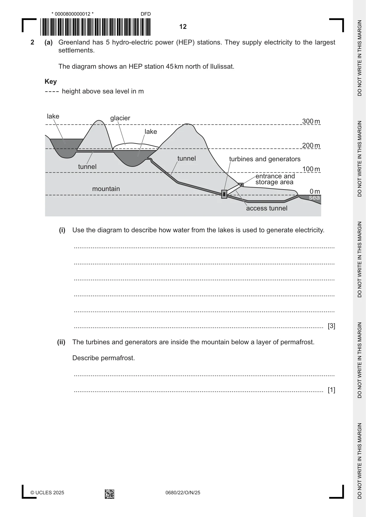
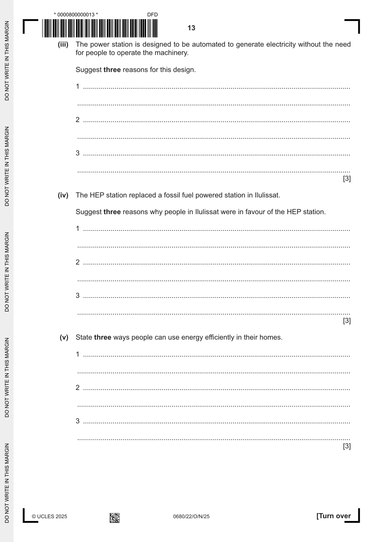
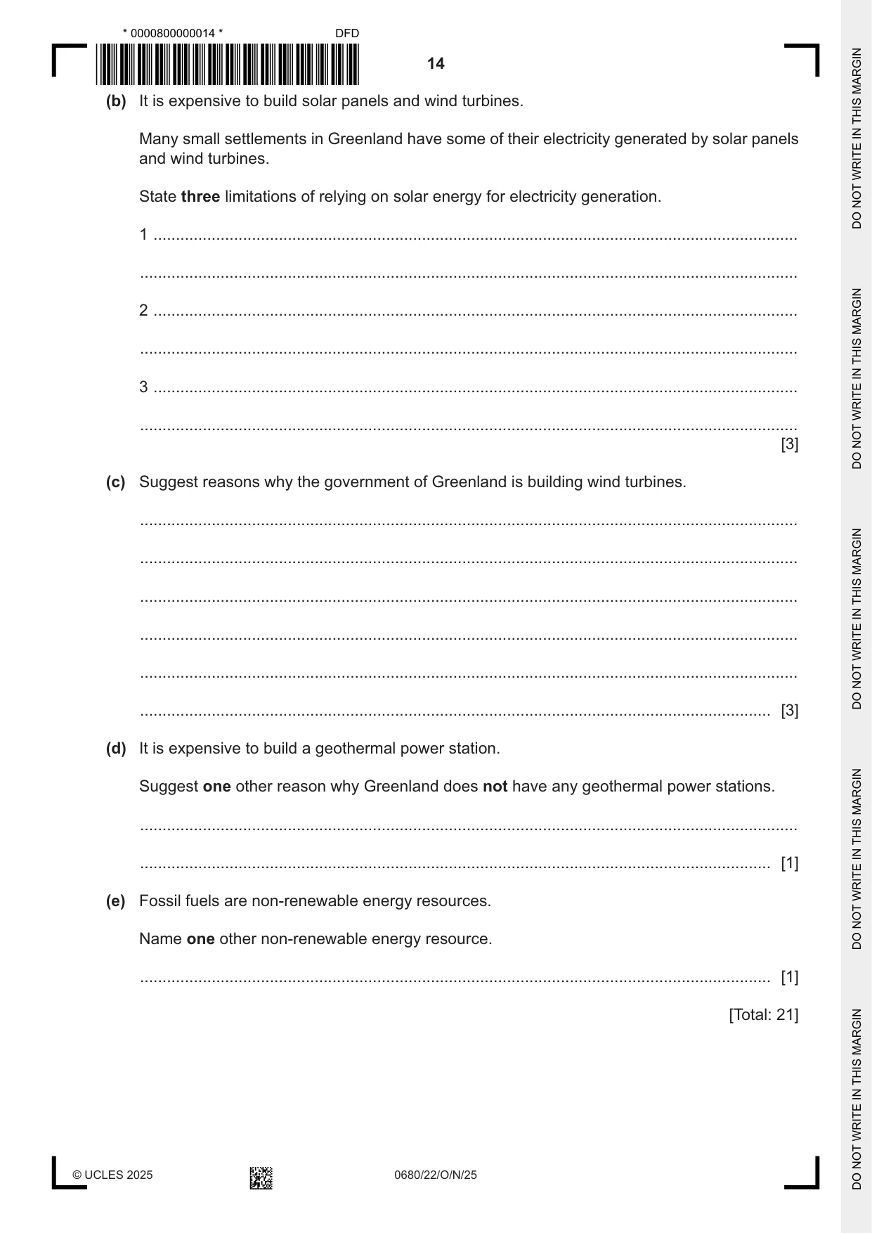
2 (a) Greenland has 5 hydro-electric power (HEP) stations. They supply electricity to the largest settlements. The diagram shows an HEP station 45 km north of Ilulissat. Key height above sea level in m lake glacier 300 m lake 200 m tunnel turbines and generators tunnel 100 m entrance and storage area mountain 0 m sea access tunnel (i) Use the diagram to describe how water from the lakes is used to generate electricity. ........................................................................................................................................... ........................................................................................................................................... ........................................................................................................................................... ........................................................................................................................................... ........................................................................................................................................... ..................................................................................................................................... [3] (ii) The turbines and generators are inside the mountain below a layer of permafrost. Describe permafrost. ........................................................................................................................................... ..................................................................................................................................... [1] (iii) The power station is designed to be automated to generate electricity without the need for people to operate the machinery. Suggest three reasons for this design. 1 ........................................................................................................................................ ........................................................................................................................................... 2 ........................................................................................................................................ ........................................................................................................................................... 3 ........................................................................................................................................ ........................................................................................................................................... [3] (iv) The HEP station replaced a fossil fuel powered station in Ilulissat. Suggest three reasons why people in Ilulissat were in favour of the HEP station. 1 ........................................................................................................................................ ........................................................................................................................................... 2 ........................................................................................................................................ ........................................................................................................................................... 3 ........................................................................................................................................ ........................................................................................................................................... [3] (v) State three ways people can use energy efficiently in their homes. 1 ........................................................................................................................................ ........................................................................................................................................... 2 ........................................................................................................................................ ........................................................................................................................................... 3 ........................................................................................................................................ ........................................................................................................................................... [3] (b) It is expensive to build solar panels and wind turbines. Many small settlements in Greenland have some of their electricity generated by solar panels and wind turbines. State three limitations of relying on solar energy for electricity generation. 1 ................................................................................................................................................ ................................................................................................................................................... 2 ................................................................................................................................................ ................................................................................................................................................... 3 ................................................................................................................................................ ................................................................................................................................................... [3] (c) Suggest reasons why the government of Greenland is building wind turbines. ................................................................................................................................................... ................................................................................................................................................... ................................................................................................................................................... ................................................................................................................................................... ................................................................................................................................................... ............................................................................................................................................. [3] (d) It is expensive to build a geothermal power station. Suggest one other reason why Greenland does not have any geothermal power stations. ................................................................................................................................................... ............................................................................................................................................. [1] (e) Fossil fuels are non-renewable energy resources. Name one other non-renewable energy resource. ............................................................................................................................................. [1] [Total: 21]
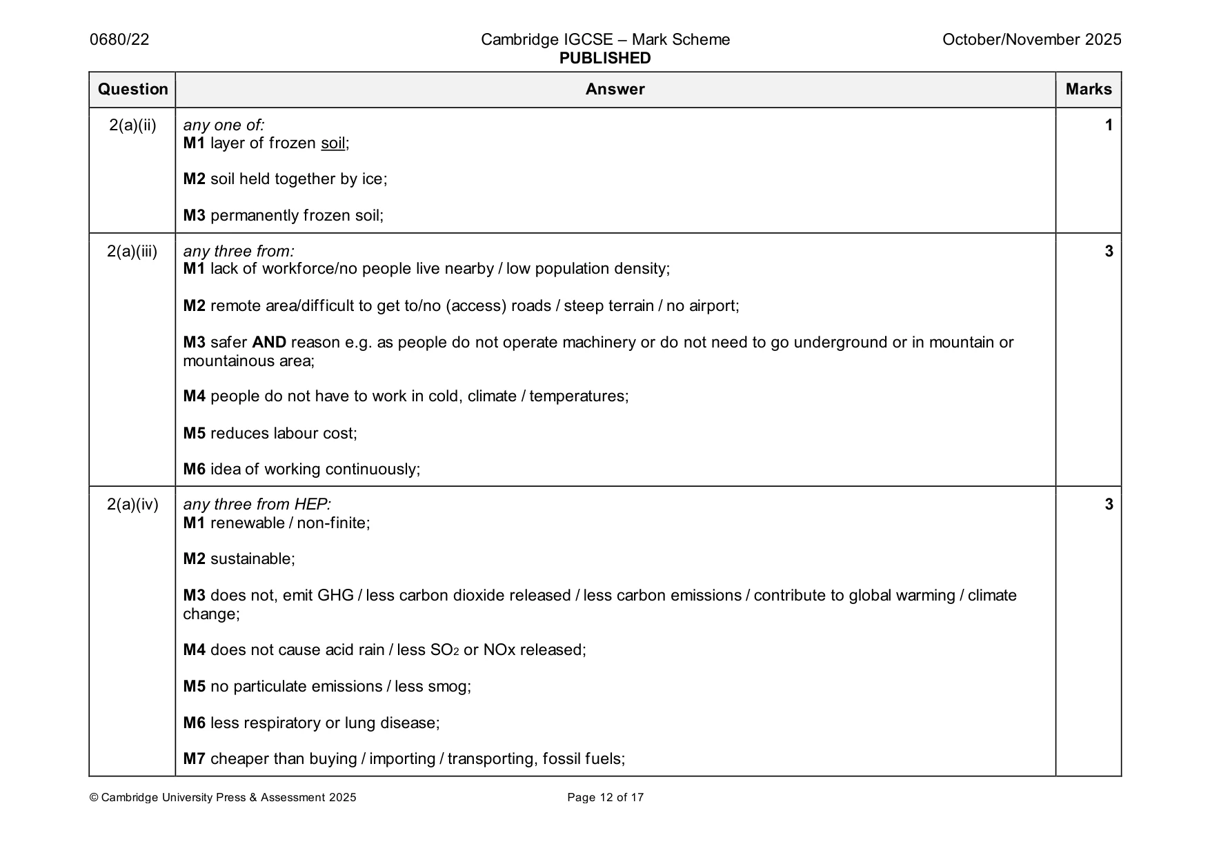
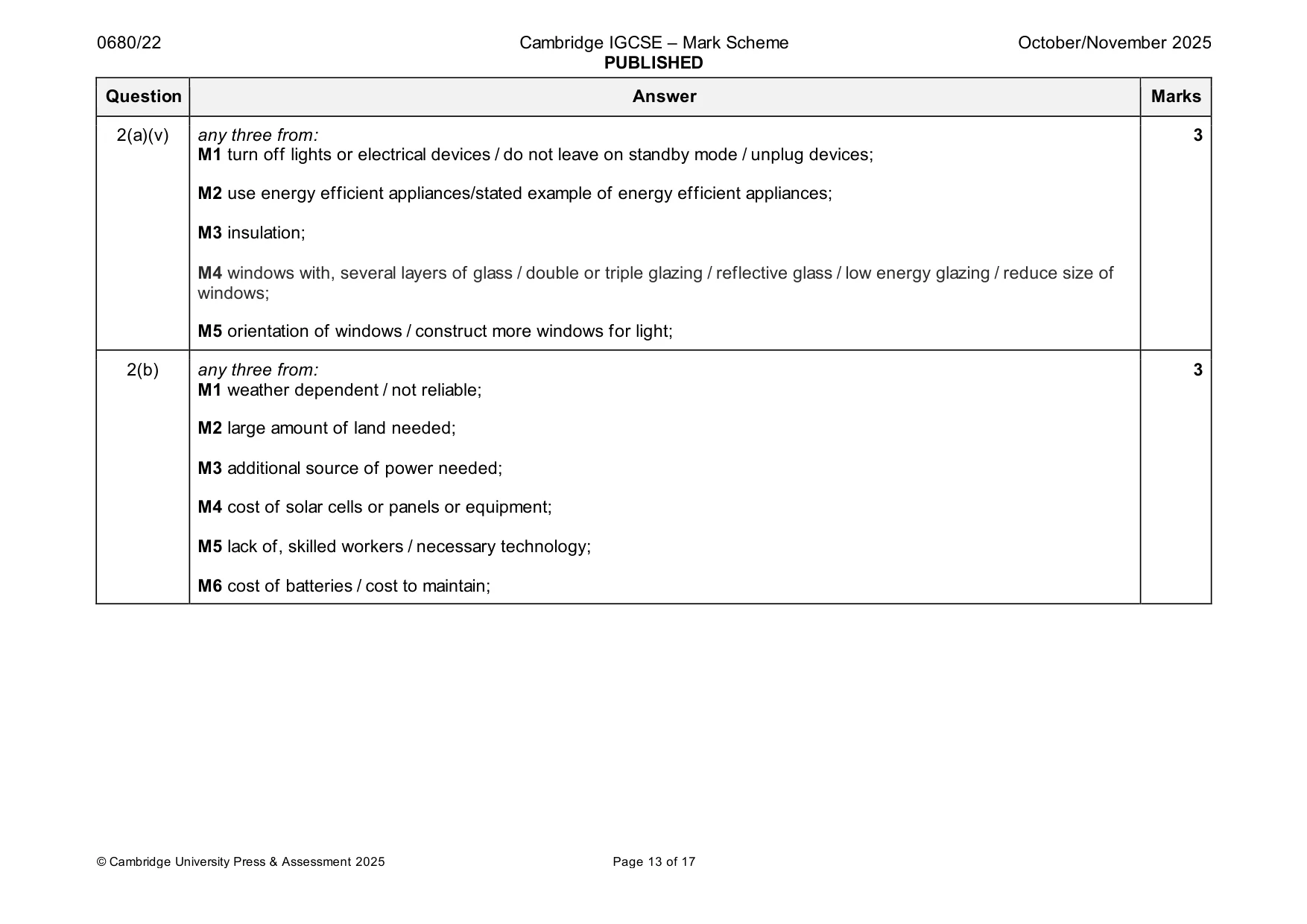
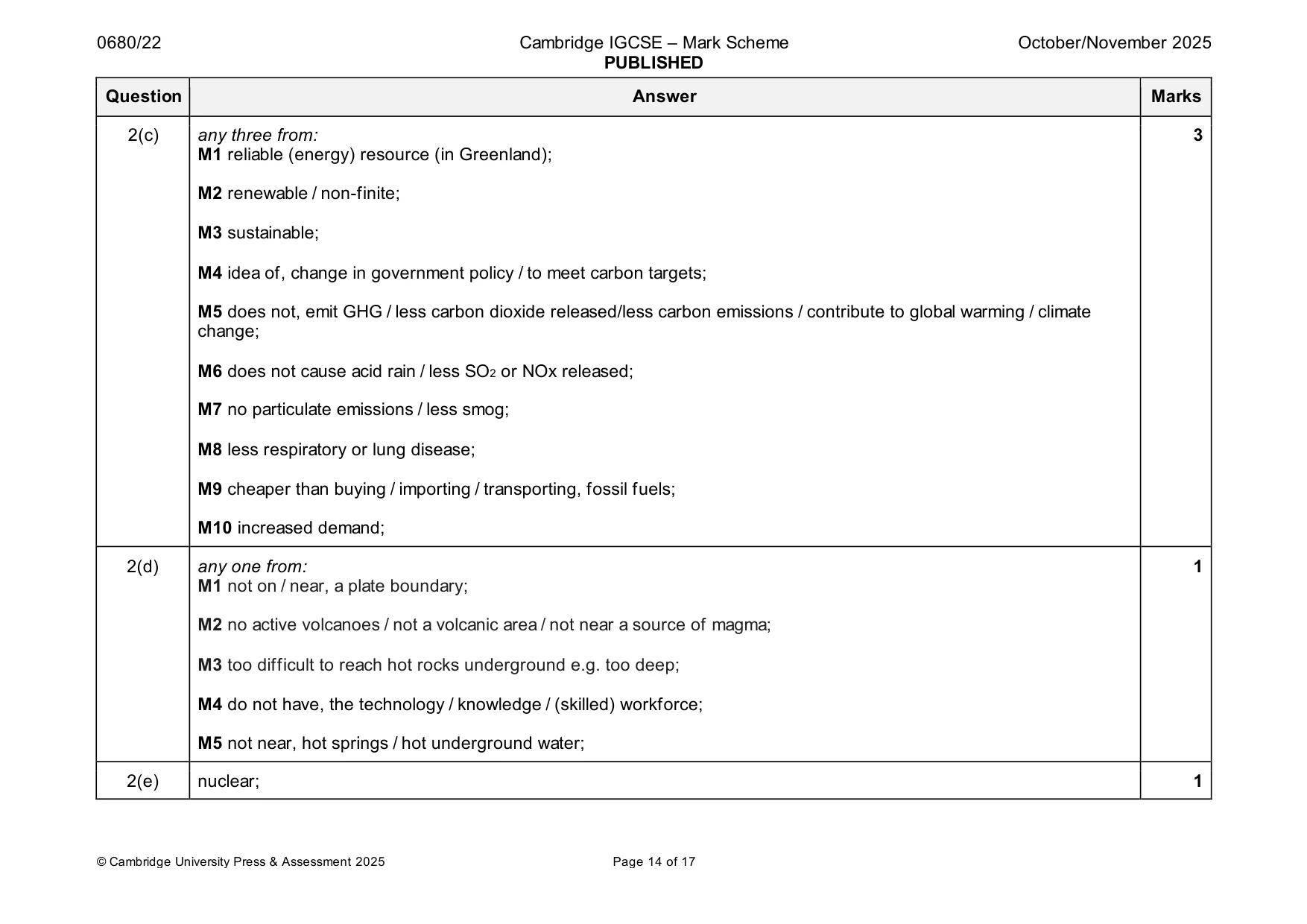
Mark scheme: 2(a)(i) M1 water or lakes are at higher level (than turbines / generators); 3 M2 water turns / spins / rotates the turbines; M3 the turbines turns / spins / rotates the generators; 2(a)(ii) any one of: 1 M1 layer of frozen soil; M2 soil held together by ice; M3 permanently frozen soil; 2(a)(iii) any three from: 3 M1 lack of workforce/no people live nearby / low population density; M2 remote area/difficult to get to/no (access) roads / steep terrain / no airport; M3 safer AND reason e.g. as people do not operate machinery or do not need to go underground or in mountain or mountainous area; M4 people do not have to work in cold, climate / temperatures; M5 reduces labour cost; M6 idea of working continuously; 2(a)(iv) any three from HEP: 3 M1 renewable / non-finite; M2 sustainable; M3 does not, emit GHG / less carbon dioxide released / less carbon emissions / contribute to global warming / climate change; M4 does not cause acid rain / less SO2 or NOx released; M5 no particulate emissions / less smog; M6 less respiratory or lung disease; M7 cheaper than buying / importing / transporting, fossil fuels; 2(a)(v) any three from: 3 M1 turn off lights or electrical devices / do not leave on standby mode / unplug devices; M2 use energy efficient appliances/stated example of energy efficient appliances; M3 insulation; M4 windows with, several layers of glass / double or triple glazing / reflective glass / low energy glazing / reduce size of windows; M5 orientation of windows / construct more windows for light; 2(b) any three from: 3 M1 weather dependent / not reliable; M2 large amount of land needed; M3 additional source of power needed; M4 cost of solar cells or panels or equipment; M5 lack of, skilled workers / necessary technology; M6 cost of batteries / cost to maintain; 2(c) any three from: 3 M1 reliable (energy) resource (in Greenland); M2 renewable / non-finite; M3 sustainable; M4 idea of, change in government policy / to meet carbon targets; M5 does not, emit GHG / less carbon dioxide released/less carbon emissions / contribute to global warming / climate change; M6 does not cause acid rain / less SO2 or NOx released; M7 no particulate emissions / less smog; M8 less respiratory or lung disease; M9 cheaper than buying / importing / transporting, fossil fuels; M10 increased demand; 2(d) any one from: 1 M1 not on / near, a plate boundary; M2 no active volcanoes / not a volcanic area / not near a source of magma; M3 too difficult to reach hot rocks underground e.g. too deep; M4 do not have, the technology / knowledge / (skilled) workforce; M5 not near, hot springs / hot underground water; 2(e) nuclear; 1
Q3 · The map shows the location of eight mines in Greenland
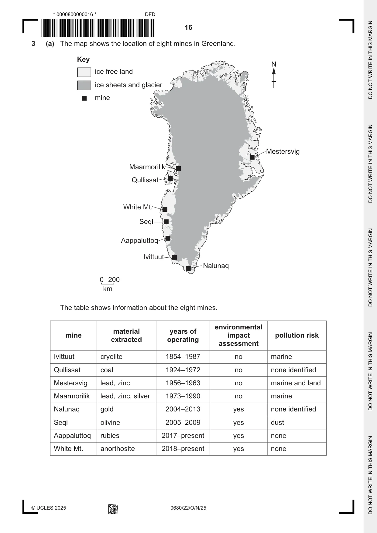
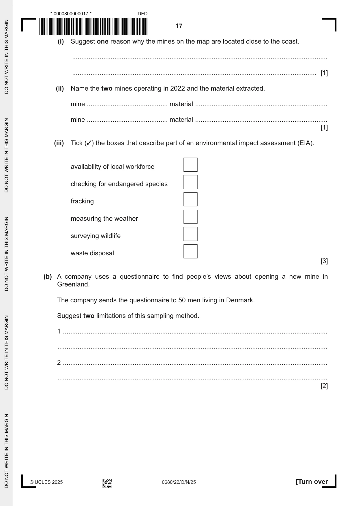
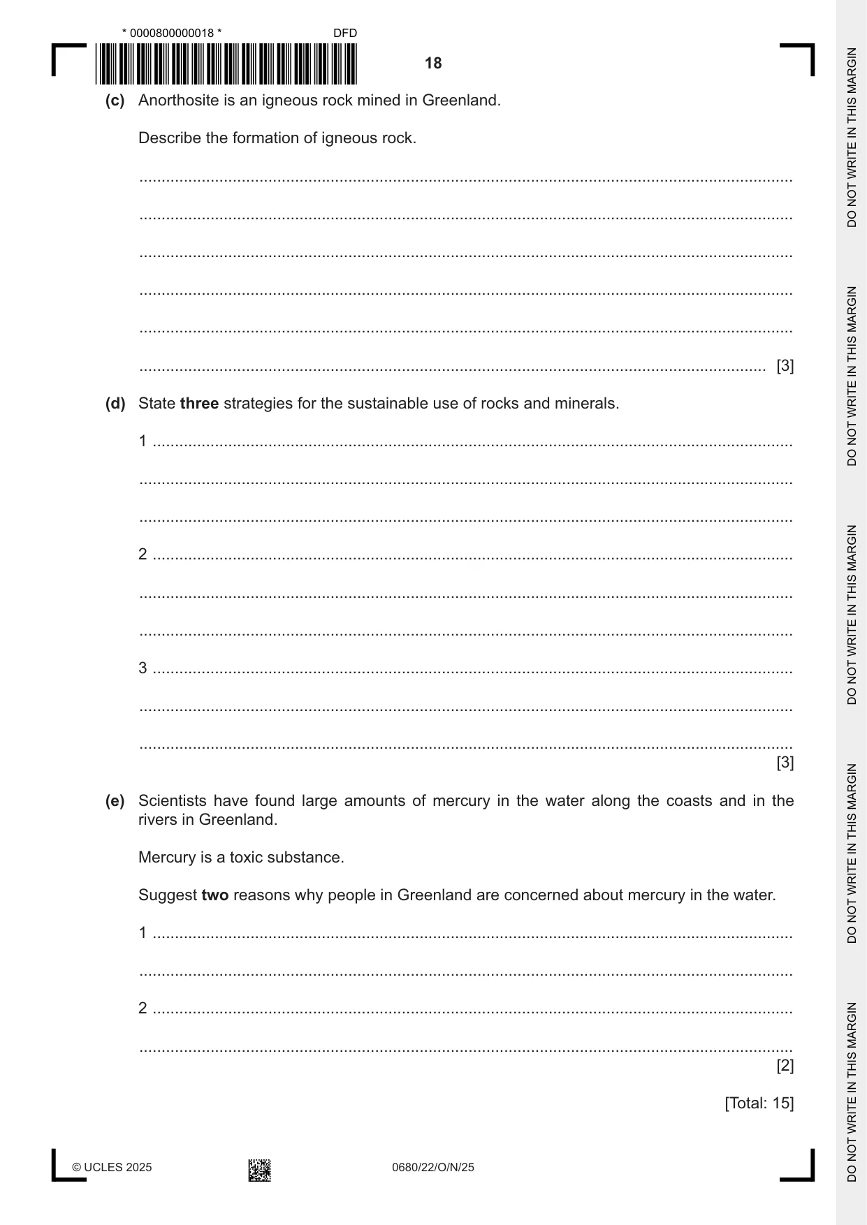
3 (a) The map shows the location of eight mines in Greenland. Key N ice free land ice sheets and glacier mine Mestersvig Maarmorilik Qullissat White Mt. Seqi Aappaluttoq Ivittuut Nalunaq 0 200 km The table shows information about the eight mines. environmental material years of mine impact pollution risk extracted operating assessment Ivittuut cryolite 1854–1987 no marine Qullissat coal 1924–1972 no none identified Mestersvig lead, zinc 1956–1963 no marine and land Maarmorilik lead, zinc, silver 1973–1990 no marine Nalunaq gold 2004–2013 yes none identified Seqi olivine 2005–2009 yes dust Aappaluttoq rubies 2017–present yes none White Mt. anorthosite 2018–present yes none (i) Suggest one reason why the mines on the map are located close to the coast. ........................................................................................................................................... ..................................................................................................................................... [1] (ii) Name the two mines operating in 2022 and the material extracted. mine ............................................ material ........................................................................ mine ............................................ material ........................................................................ [1] (iii) Tick (✓) the boxes that describe part of an environmental impact assessment (EIA). availability of local workforce checking for endangered species fracking measuring the weather surveying wildlife waste disposal [3] (b) A company uses a questionnaire to find people’s views about opening a new mine in Greenland. The company sends the questionnaire to 50 men living in Denmark. Suggest two limitations of this sampling method. 1 ................................................................................................................................................ ................................................................................................................................................... 2 ................................................................................................................................................ ................................................................................................................................................... [2] (c) Anorthosite is an igneous rock mined in Greenland. Describe the formation of igneous rock. ................................................................................................................................................... ................................................................................................................................................... ................................................................................................................................................... ................................................................................................................................................... ................................................................................................................................................... ............................................................................................................................................. [3] (d) State three strategies for the sustainable use of rocks and minerals. 1 ................................................................................................................................................ ................................................................................................................................................... ................................................................................................................................................... 2 ................................................................................................................................................ ................................................................................................................................................... ................................................................................................................................................... 3 ................................................................................................................................................ ................................................................................................................................................... ................................................................................................................................................... [3] (e) Scientists have found large amounts of mercury in the water along the coasts and in the rivers in Greenland. Mercury is a toxic substance. Suggest two reasons why people in Greenland are concerned about mercury in the water. 1 ................................................................................................................................................ ................................................................................................................................................... 2 ................................................................................................................................................ ................................................................................................................................................... [2] [Total: 15]
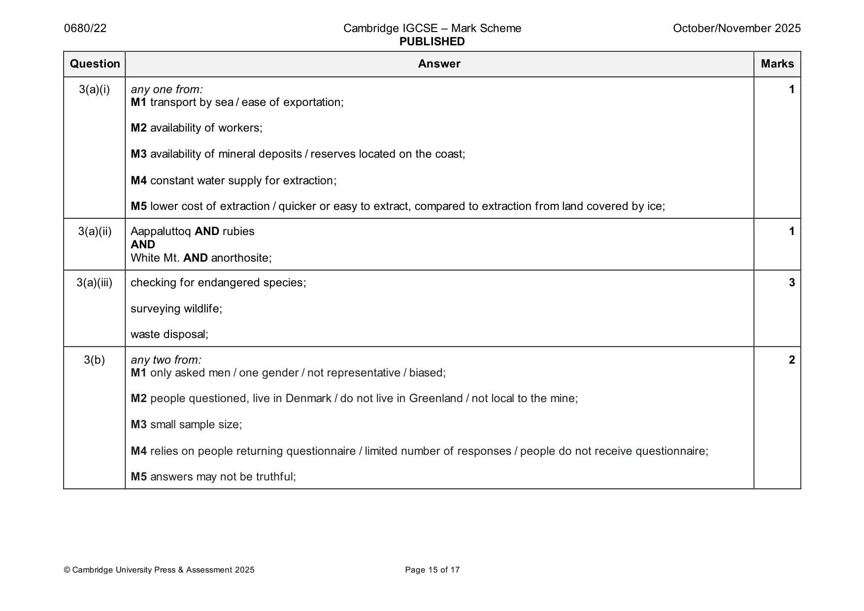
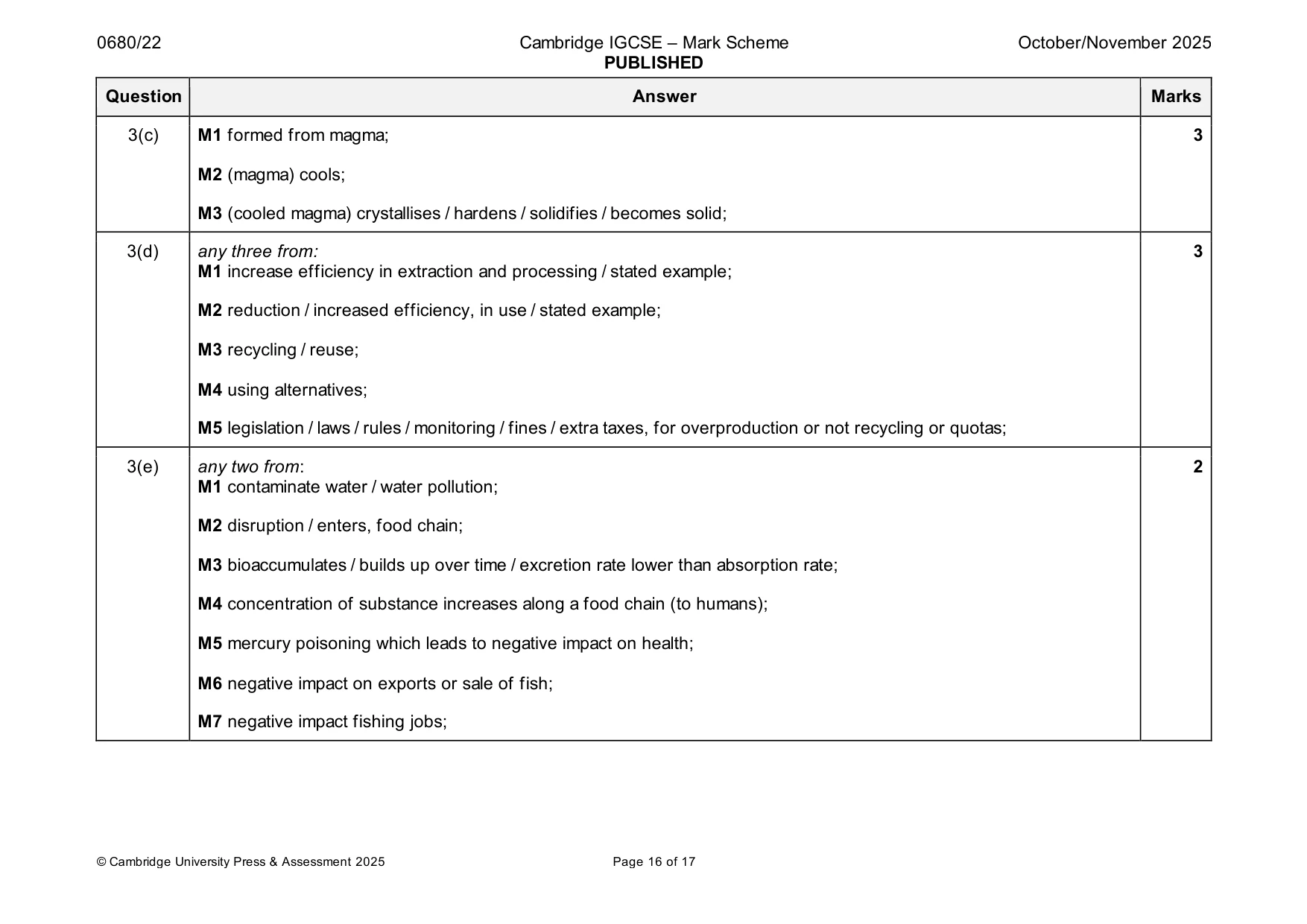
Mark scheme: 3(a)(i) any one from: 1 M1 transport by sea / ease of exportation; M2 availability of workers; M3 availability of mineral deposits / reserves located on the coast; M4 constant water supply for extraction; M5 lower cost of extraction / quicker or easy to extract, compared to extraction from land covered by ice; 3(a)(ii) Aappaluttoq AND rubies 1 AND White Mt. AND anorthosite; 3(a)(iii) checking for endangered species; 3 surveying wildlife; waste disposal; 3(b) any two from: 2 M1 only asked men / one gender / not representative / biased; M2 people questioned, live in Denmark / do not live in Greenland / not local to the mine; M3 small sample size; M4 relies on people returning questionnaire / limited number of responses / people do not receive questionnaire; M5 answers may not be truthful; 3(c) M1 formed from magma; 3 M2 (magma) cools; M3 (cooled magma) crystallises / hardens / solidifies / becomes solid; 3(d) any three from: 3 M1 increase efficiency in extraction and processing / stated example; M2 reduction / increased efficiency, in use / stated example; M3 recycling / reuse; M4 using alternatives; M5 legislation / laws / rules / monitoring / fines / extra taxes, for overproduction or not recycling or quotas; 3(e) any two from: 2 M1 contaminate water / water pollution; M2 disruption / enters, food chain; M3 bioaccumulates / builds up over time / excretion rate lower than absorption rate; M4 concentration of substance increases along a food chain (to humans); M5 mercury poisoning which leads to negative impact on health; M6 negative impact on exports or sale of fish; M7 negative impact fishing jobs;
Q4 · A report states that the largest ice sheet in Greenland is getting smaller
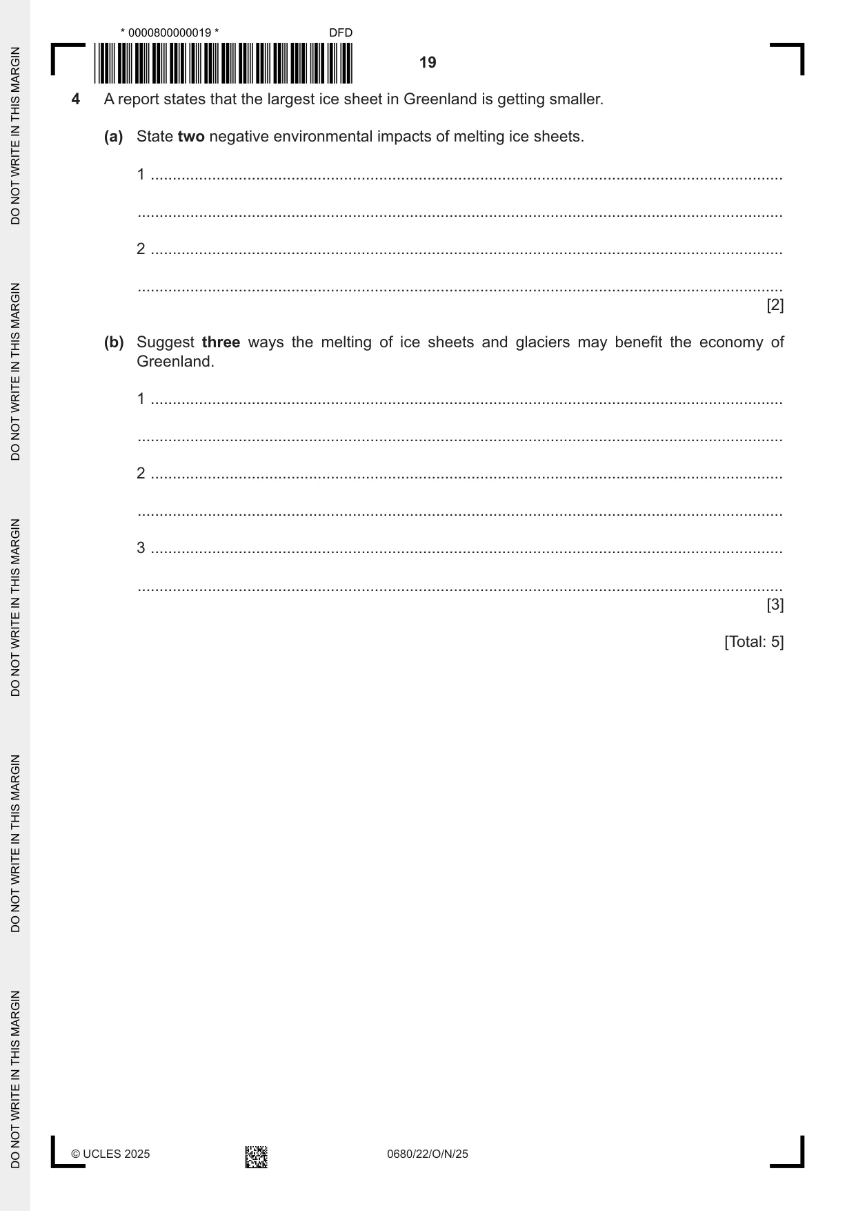
4 A report states that the largest ice sheet in Greenland is getting smaller. (a) State two negative environmental impacts of melting ice sheets. 1 ................................................................................................................................................ ................................................................................................................................................... 2 ................................................................................................................................................ ................................................................................................................................................... [2] (b) Suggest three ways the melting of ice sheets and glaciers may benefit the economy of Greenland. 1 ................................................................................................................................................ ................................................................................................................................................... 2 ................................................................................................................................................ ................................................................................................................................................... 3 ................................................................................................................................................ ................................................................................................................................................... [3] [Total: 5]
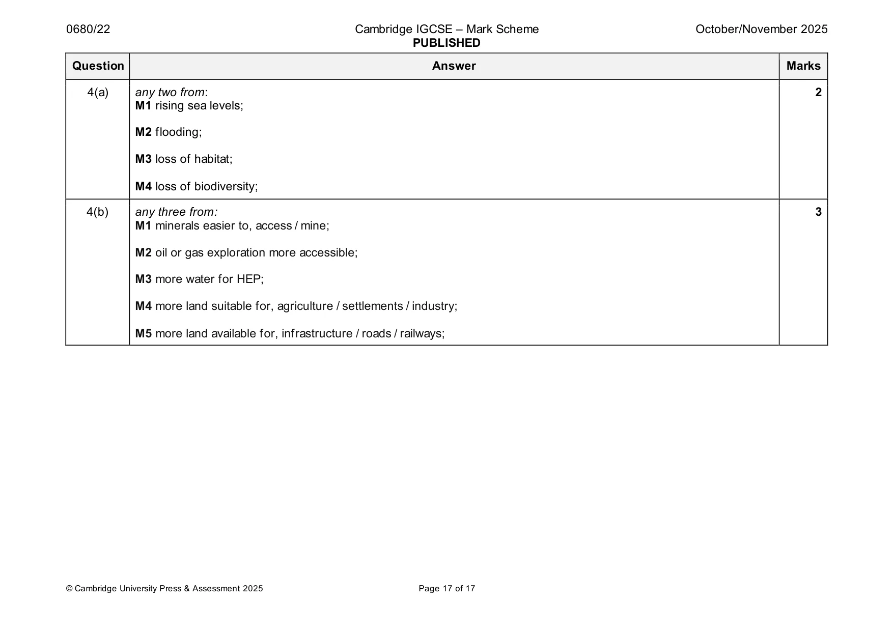
Mark scheme: 4(a) any two from: 2 M1 rising sea levels; M2 flooding; M3 loss of habitat; M4 loss of biodiversity; 4(b) any three from: 3 M1 minerals easier to, access / mine; M2 oil or gas exploration more accessible; M3 more water for HEP; M4 more land suitable for, agriculture / settlements / industry; M5 more land available for, infrastructure / roads / railways;
What was in this paper
The subtopics covered by these 4 questions, and how many questions each got. Open one in a new tab to see every Cambridge question on it.
What you needed in this session
Cambridge’s own grade thresholds for 2025 Oct/Nov, Paper 2 · Variant 2. A higher threshold means an easier paper — the bar moves with how the cohort did.