Cambridge IGCSE Geography 0460 — 2016 Oct/Nov Paper 2 · Variant 2
0460/22/O/N/16 · 60 marks · ≈68 min
The question paper and its mark scheme, free to read here and free to download. This is Cambridge’s own paper, exactly as it was sat.
Question paper20 pages
Mark scheme5 pages
Answers below. Sit the paper first if you are practising.
Paper as text
Question paper, page 1
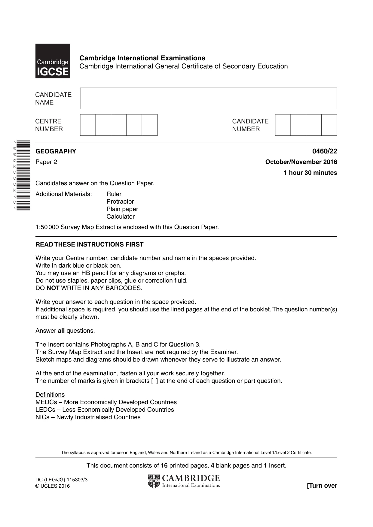
This document consists of 16 printed pages, 4 blank pages and 1 Insert. DC (LEG/JG) 115303/3 © UCLES 2016 [Turn over Cambridge International Examinations Cambridge International General Certificate of Secondary Education * 8 9 6 2 5 0 0 2 7 0 * GEOGRAPHY 0460/22 Paper 2 October/November 2016 1 hour 30 minutes Candidates answer on the Question Paper. Additional Materials: Ruler Protractor Plain paper Calculator 1:50 000 Survey Map Extract is enclosed with this Question Paper. READ THESE INSTRUCTIONS FIRST Write your Centre number, candidate number and name in the spaces provided. Write in dark blue or black pen. You may use an HB pencil for any diagrams or graphs. Do not use staples, paper clips, glue or correction fluid. DO NOT WRITE IN ANY BARCODES. Write your answer to each question in the space provided. If additional space is required, you should use the lined pages at the end of the booklet. The question number(s) must be clearly shown. Answer all questions. The Insert contains Photographs A, B and C for Question 3. The Survey Map Extract and the Insert are not required by the Examiner. Sketch maps and diagrams should be drawn whenever they serve to illustrate an answer. At the end of the examination, fasten all your work securely together. The number of marks is given in brackets [ ] at the end of each question or part question. Definitions MEDCs – More Economically Developed Countries LEDCs – Less Economically Developed Countries NICs – Newly Industrialised Countries The syllabus is approved for use in England, Wales and Northern Ireland as a Cambridge International Level 1/Level 2 Certificate.
Question paper, page 2
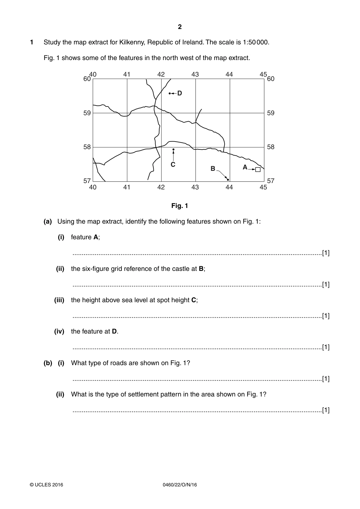
2 0460/22/O/N/16 © UCLES 2016 1 Study the map extract for Kilkenny, Republic of Ireland. The scale is 1:50 000. Fig. 1 shows some of the features in the north west of the map extract. 60 59 58 57 60 59 58 57 40 41 42 43 44 45 40 41 42 43 44 45 D A B C Fig. 1 (a) Using the map extract, identify the following features shown on Fig. 1: (i) feature A; …[1] (ii) the six-figure grid reference of the castle at B; …[1] (iii) the height above sea level at spot height C; …[1] (iv) the feature at D. …[1] (b) (i) What type of roads are shown on Fig. 1? …[1] (ii) What is the type of settlement pattern in the area shown on Fig. 1? …[1]
Question paper, page 3
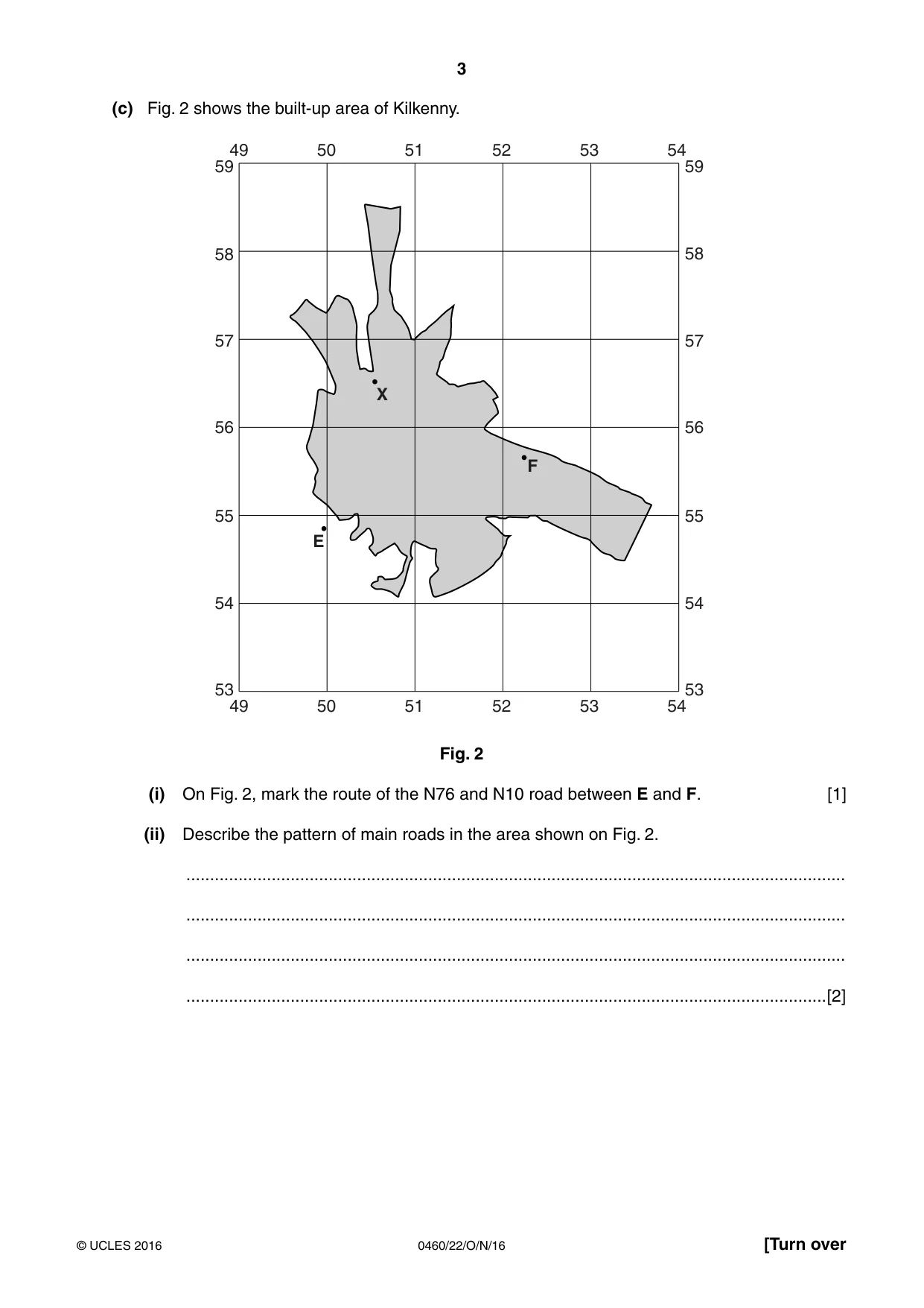
3 0460/22/O/N/16 © UCLES 2016 [Turn over (c) Fig. 2 shows the built-up area of Kilkenny. X F E 59 58 57 56 55 54 53 59 58 57 56 55 54 53 49 50 51 52 53 54 49 50 51 52 53 54 Fig. 2 (i) On Fig. 2, mark the route of the N76 and N10 road between E and F. [1] (ii) Describe the pattern of main roads in the area shown on Fig. 2. … … … …[2]
Question paper, page 4
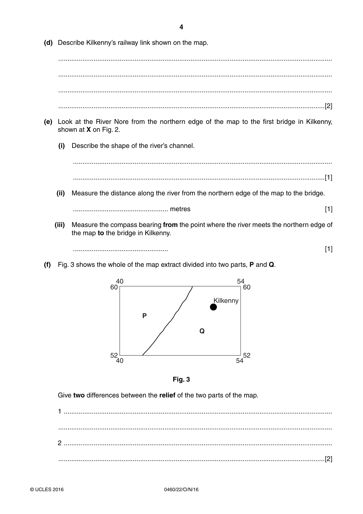
4 0460/22/O/N/16 © UCLES 2016 (d) Describe Kilkenny’s railway link shown on the map. … … … …[2] (e) Look at the River Nore from the northern edge of the map to the first bridge in Kilkenny, shown at X on Fig. 2. (i) Describe the shape of the river’s channel. … …[1] (ii) Measure the distance along the river from the northern edge of the map to the bridge. … metres [1] (iii) Measure the compass bearing from the point where the river meets the northern edge of the map to the bridge in Kilkenny. … [1] (f) Fig. 3 shows the whole of the map extract divided into two parts, P and Q. P Q 40 54 60 52 60 52 40 54 Kilkenny Fig. 3 Give two differences between the relief of the two parts of the map. 1 … … 2 … …[2]
Question paper, page 5
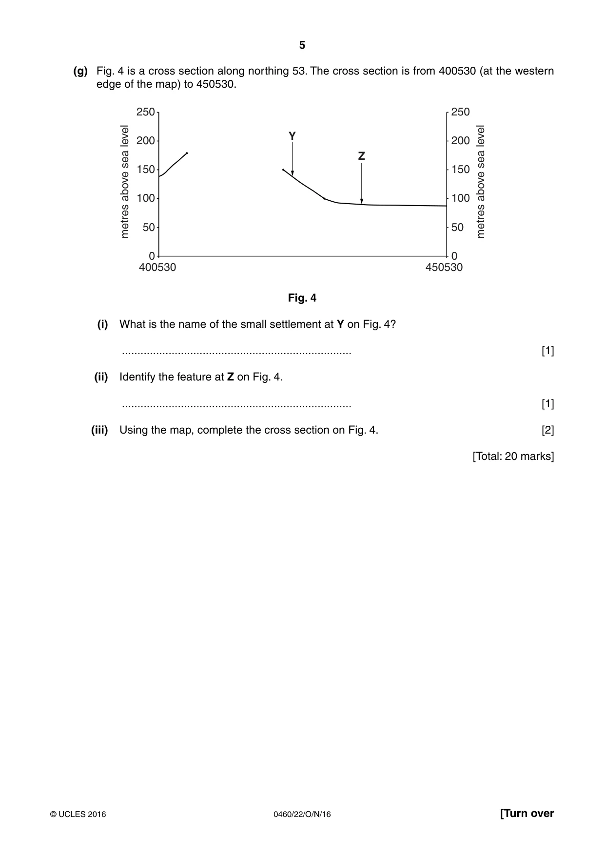
5 0460/22/O/N/16 © UCLES 2016 [Turn over (g) Fig. 4 is a cross section along northing 53. The cross section is from 400530 (at the western edge of the map) to 450530. metres above sea level metres above sea level 250 200 150 100 50 0 250 200 150 100 50 0 400530 450530 Y Z Fig. 4 (i) What is the name of the small settlement at Y on Fig. 4? … [1] (ii) Identify the feature at Z on Fig. 4. … [1] (iii) Using the map, complete the cross section on Fig. 4. [2] [Total: 20 marks]
Question paper, page 6
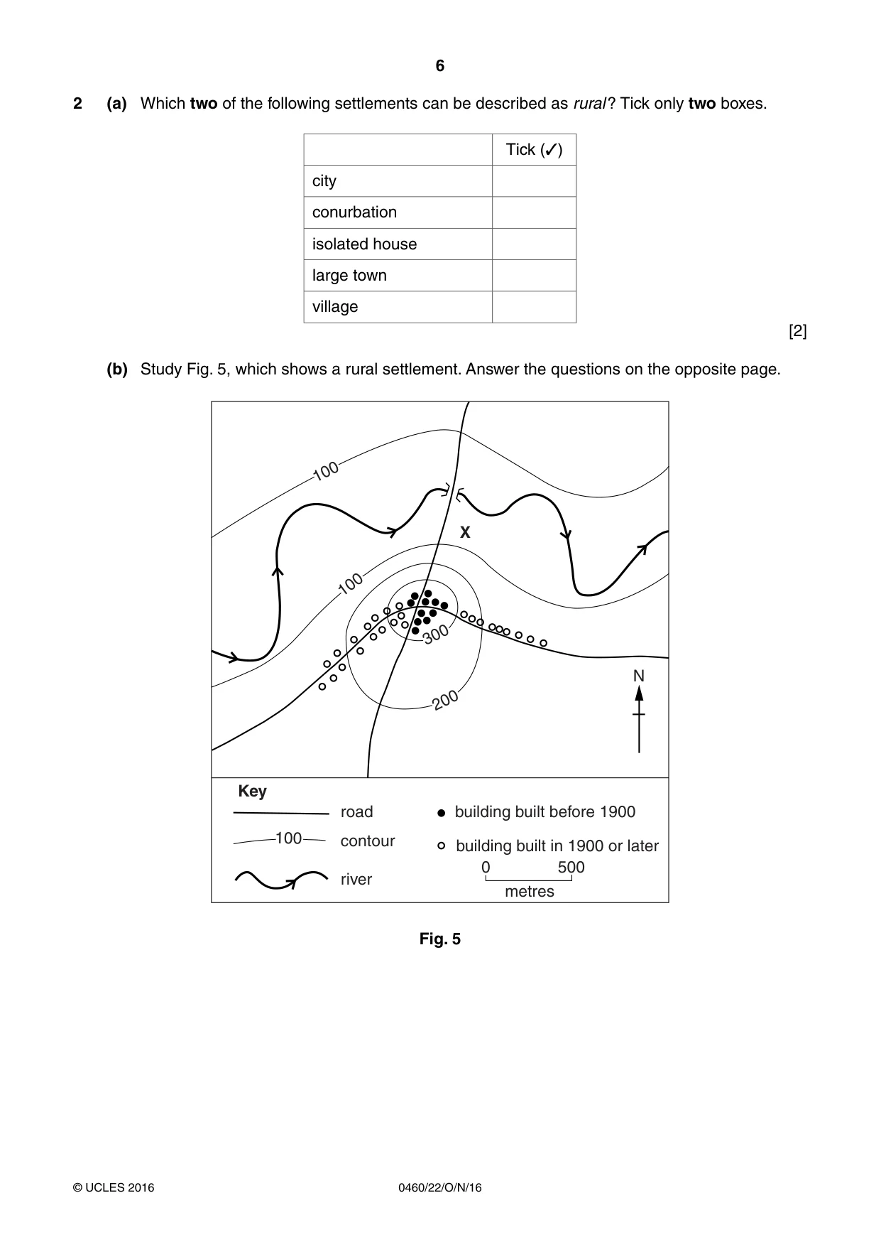
6 0460/22/O/N/16 © UCLES 2016 2 (a) Which two of the following settlements can be described as rural ? Tick only two boxes. Tick (✓) city conurbation isolated house large town village [2] (b) Study Fig. 5, which shows a rural settlement. Answer the questions on the opposite page. 100 100 100 300 200 N road Key building built before 1900 contour building built in 1900 or later river 0 500 metres X Fig. 5
Question paper, page 7
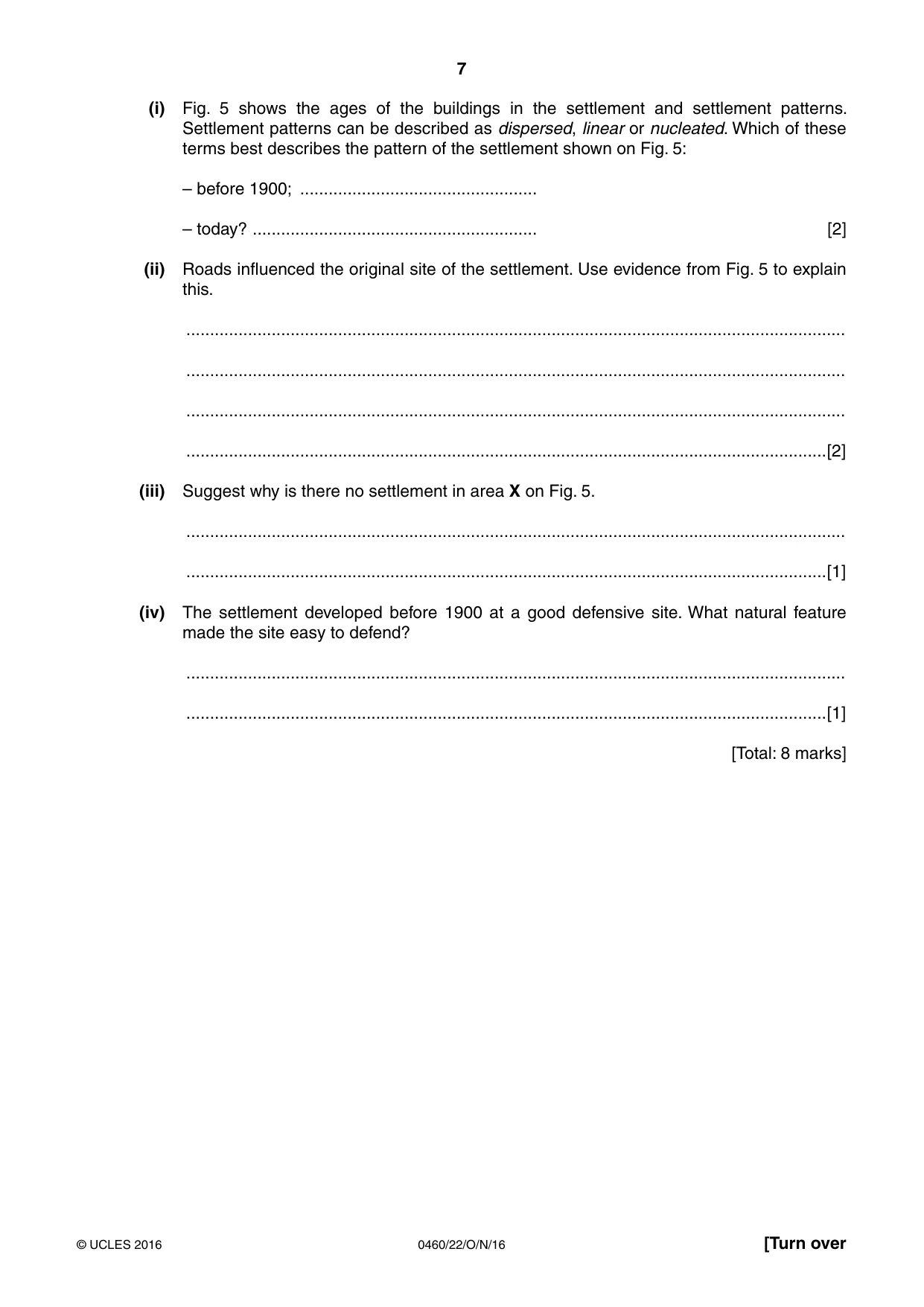
7 0460/22/O/N/16 © UCLES 2016 [Turn over (i) Fig. 5 shows the ages of the buildings in the settlement and settlement patterns. Settlement patterns can be described as dispersed, linear or nucleated. Which of these terms best describes the pattern of the settlement shown on Fig. 5: – before 1900; … – today? … [2] (ii) Roads influenced the original site of the settlement. Use evidence from Fig. 5 to explain this. … … … …[2] (iii) Suggest why is there no settlement in area X on Fig. 5. … …[1] (iv) The settlement developed before 1900 at a good defensive site. What natural feature made the site easy to defend? … …[1] [Total: 8 marks]
Question paper, page 8
8 0460/22/O/N/16 © UCLES 2016 BLANK PAGE
Question paper, page 9
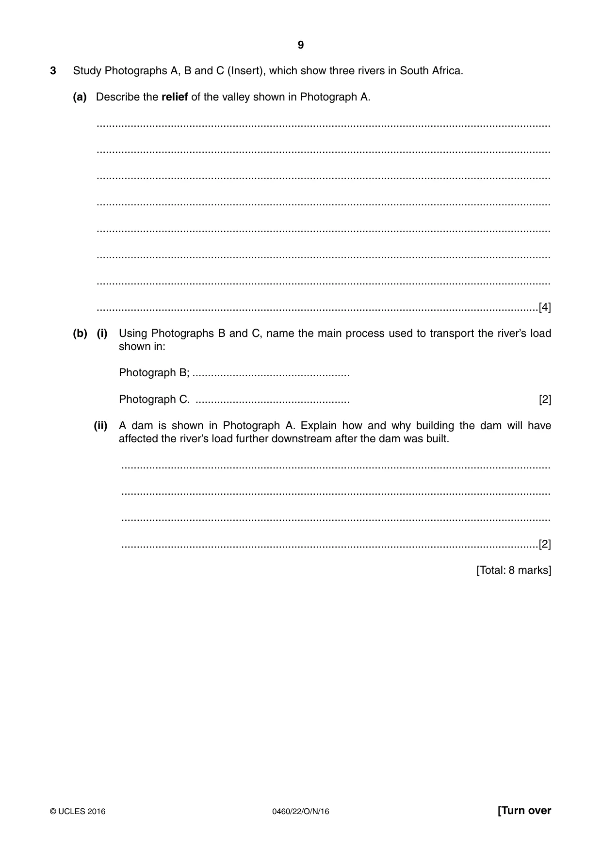
9 0460/22/O/N/16 © UCLES 2016 [Turn over 3 Study Photographs A, B and C (Insert), which show three rivers in South Africa. (a) Describe the relief of the valley shown in Photograph A. … … … … … … … …[4] (b) (i) Using Photographs B and C, name the main process used to transport the river’s load shown in: Photograph B; … Photograph C. … [2] (ii) A dam is shown in Photograph A. Explain how and why building the dam will have affected the river’s load further downstream after the dam was built. … … … …[2] [Total: 8 marks]
Question paper, page 10
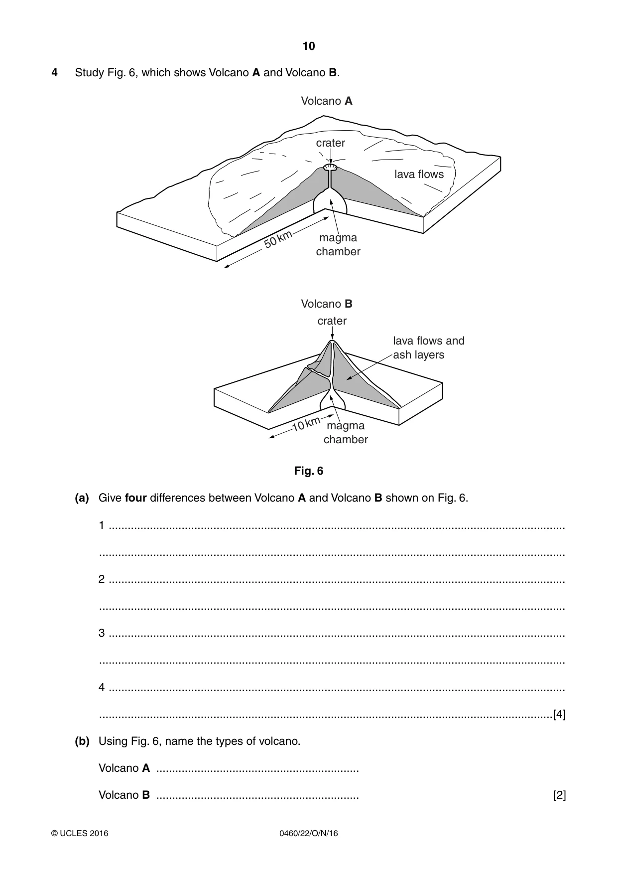
10 0460/22/O/N/16 © UCLES 2016 4 Study Fig. 6, which shows Volcano A and Volcano B. lava flows lava flows and ash layers magma chamber magma chamber crater crater 50 km 10 km Volcano A Volcano B Fig. 6 (a) Give four differences between Volcano A and Volcano B shown on Fig. 6. 1 … … 2 … … 3 … … 4 … …[4] (b) Using Fig. 6, name the types of volcano. Volcano A … Volcano B … [2]
Question paper, page 11
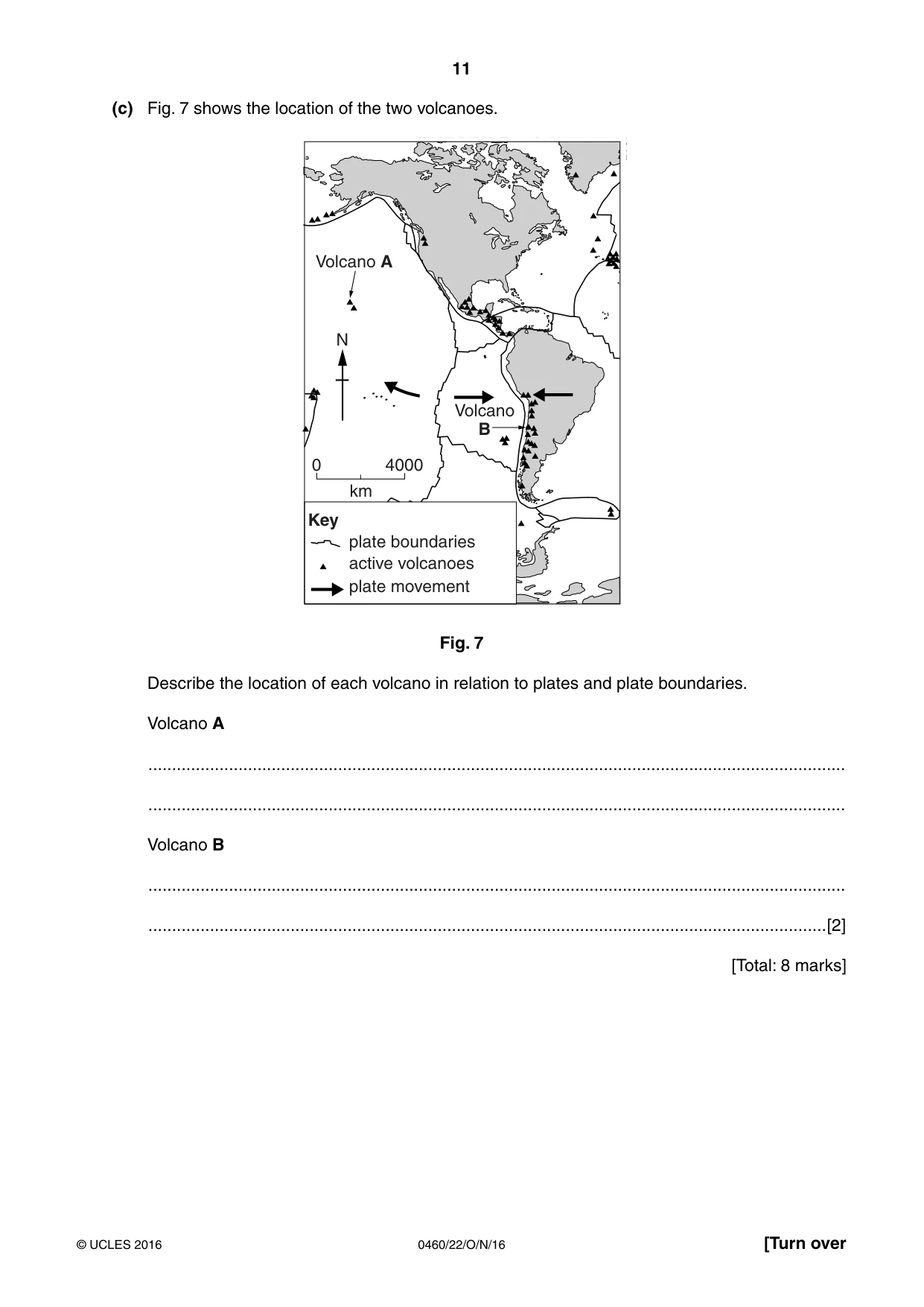
11 0460/22/O/N/16 © UCLES 2016 [Turn over (c) Fig. 7 shows the location of the two volcanoes. Volcano A Volcano B N Key plate boundaries active volcanoes plate movement 0 4000 km Fig. 7 Describe the location of each volcano in relation to plates and plate boundaries. Volcano A … … Volcano B … …[2] [Total: 8 marks]
Question paper, page 12
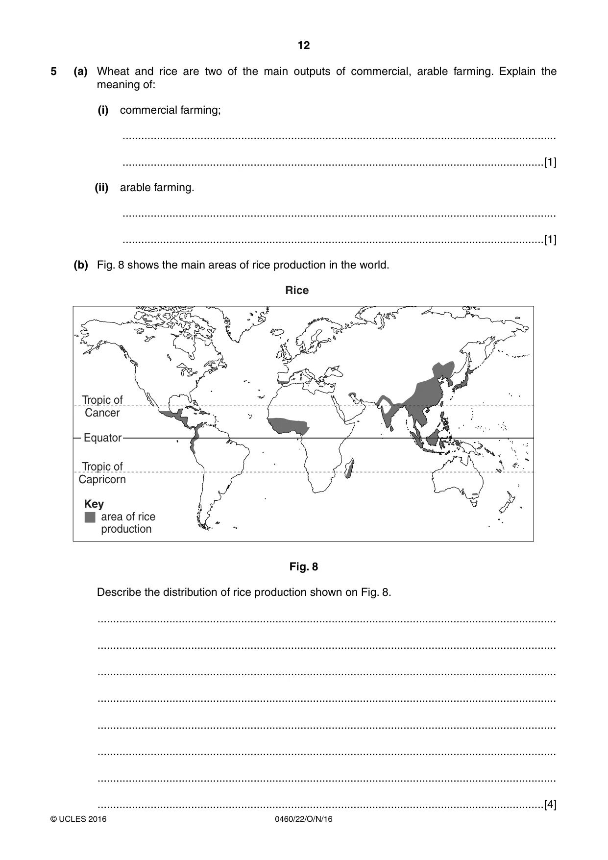
12 0460/22/O/N/16 © UCLES 2016 5 (a) Wheat and rice are two of the main outputs of commercial, arable farming. Explain the meaning of: (i) commercial farming; … …[1] (ii) arable farming. … …[1] (b) Fig. 8 shows the main areas of rice production in the world. Equator Tropic of Capricorn Tropic of Cancer area of rice production Key Rice Fig. 8 Describe the distribution of rice production shown on Fig. 8. … … … … … … … …[4]
Question paper, page 13
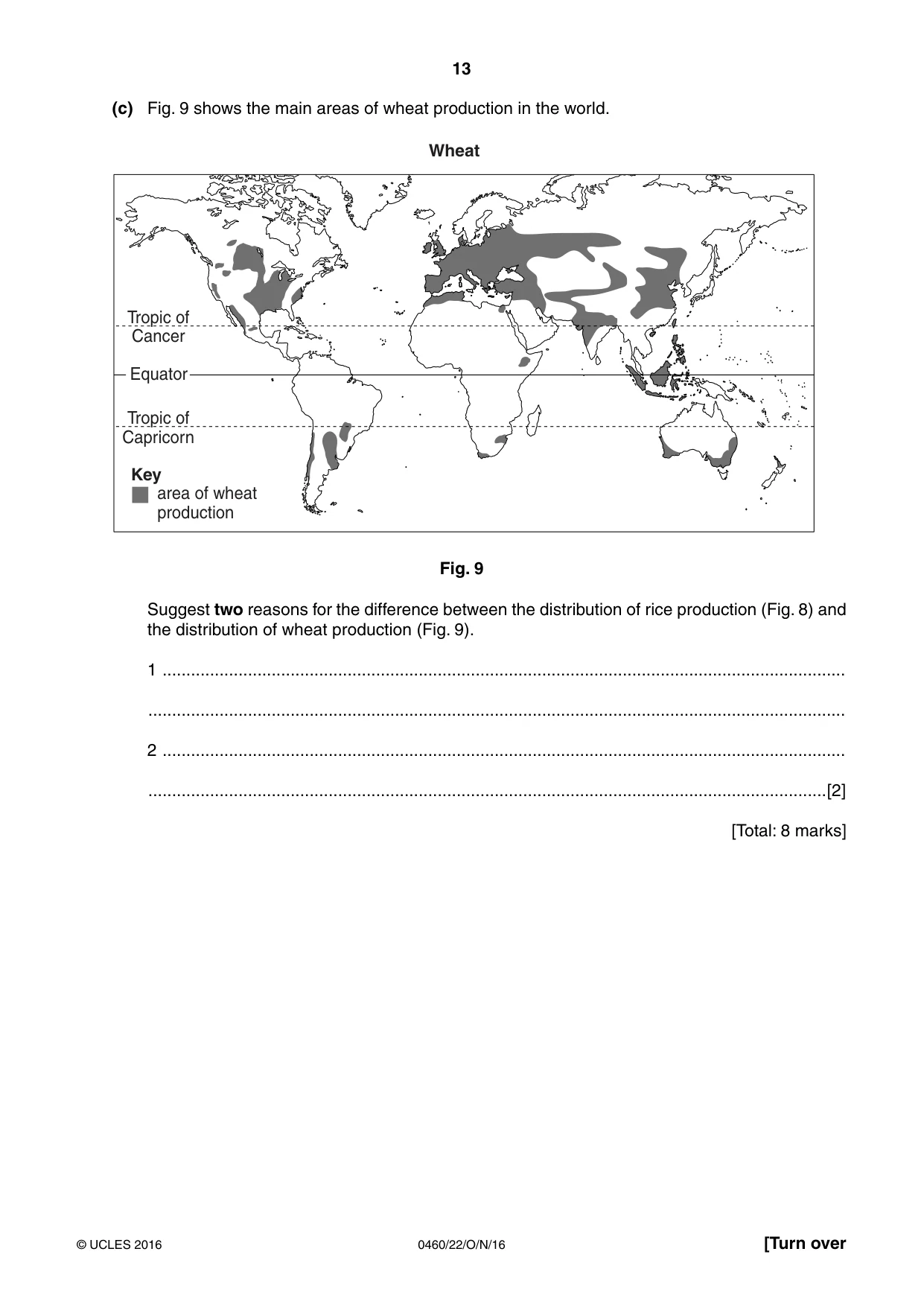
13 0460/22/O/N/16 © UCLES 2016 [Turn over (c) Fig. 9 shows the main areas of wheat production in the world. Equator Tropic of Capricorn Tropic of Cancer area of wheat production Key Wheat Fig. 9 Suggest two reasons for the difference between the distribution of rice production (Fig. 8) and the distribution of wheat production (Fig. 9). 1 … … 2 … …[2] [Total: 8 marks]
Question paper, page 14
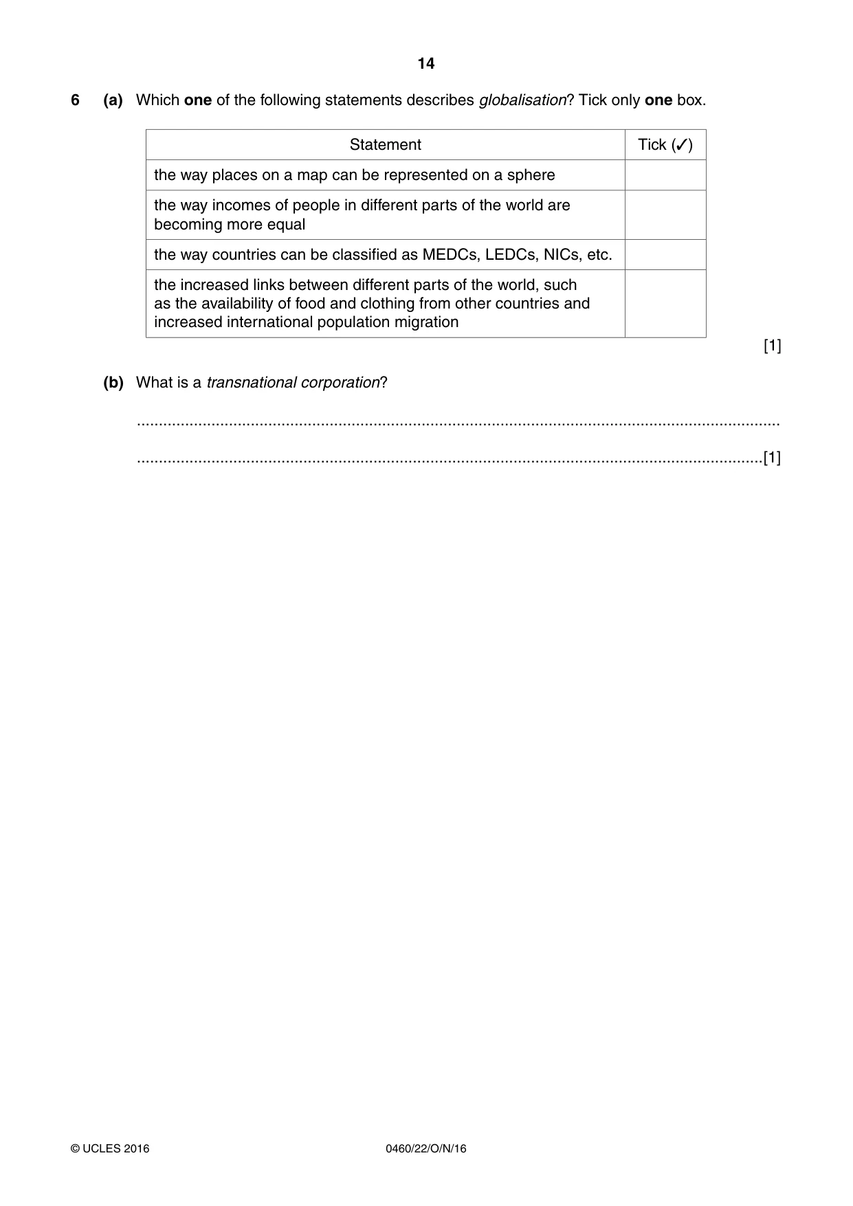
14 0460/22/O/N/16 © UCLES 2016 6 (a) Which one of the following statements describes globalisation? Tick only one box. Statement Tick (✓) the way places on a map can be represented on a sphere the way incomes of people in different parts of the world are becoming more equal the way countries can be classified as MEDCs, LEDCs, NICs, etc. the increased links between different parts of the world, such as the availability of food and clothing from other countries and increased international population migration [1] (b) What is a transnational corporation? … …[1]
Question paper, page 15
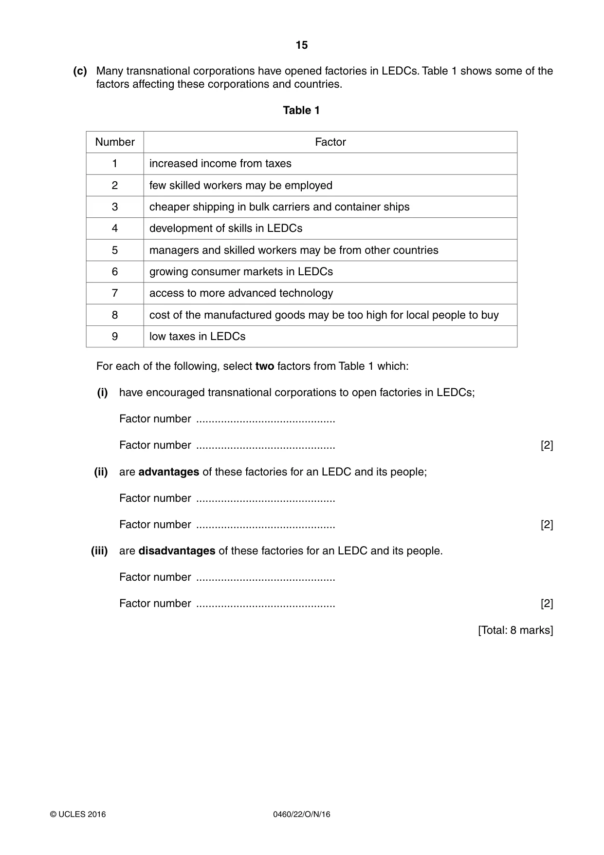
15 0460/22/O/N/16 © UCLES 2016 (c) Many transnational corporations have opened factories in LEDCs. Table 1 shows some of the factors affecting these corporations and countries. Table 1 Number Factor 1 increased income from taxes 2 few skilled workers may be employed 3 cheaper shipping in bulk carriers and container ships 4 development of skills in LEDCs 5 managers and skilled workers may be from other countries 6 growing consumer markets in LEDCs 7 access to more advanced technology 8 cost of the manufactured goods may be too high for local people to buy 9 low taxes in LEDCs For each of the following, select two factors from Table 1 which: (i) have encouraged transnational corporations to open factories in LEDCs; Factor number … Factor number … [2] (ii) are advantages of these factories for an LEDC and its people; Factor number … Factor number … [2] (iii) are disadvantages of these factories for an LEDC and its people. Factor number … Factor number … [2] [Total: 8 marks]
Question paper, page 16
16 0460/22/O/N/16 © UCLES 2016 Additional Pages If you use the following lined pages to complete the answer(s) to any question(s), the question number(s) must be clearly shown. … … … … … … … … … … … … … … … … … … … … … … … … … …
Question paper, page 17
17 0460/22/O/N/16 © UCLES 2016 … … … … … … … … … … … … … … … … … … … … … … … … … … …
Question paper, page 18
18 0460/22/O/N/16 © UCLES 2016 BLANK PAGE
Question paper, page 19
19 0460/22/O/N/16 © UCLES 2016 BLANK PAGE
Question paper, page 20
20 0460/22/O/N/16 © UCLES 2016 Permission to reproduce items where third-party owned material protected by copyright is included has been sought and cleared where possible. Every reasonable effort has been made by the publisher (UCLES) to trace copyright holders, but if any items requiring clearance have unwittingly been included, the publisher will be pleased to make amends at the earliest possible opportunity. To avoid the issue of disclosure of answer-related information to candidates, all copyright acknowledgements are reproduced online in the Cambridge International Examinations Copyright Acknowledgements Booklet. This is produced for each series of examinations and is freely available to download at www.cie.org.uk after the live examination series. Cambridge International Examinations is part of the Cambridge Assessment Group. Cambridge Assessment is the brand name of University of Cambridge Local Examinations Syndicate (UCLES), which is itself a department of the University of Cambridge. BLANK PAGE
Mark scheme, page 1
® IGCSE is the registered trademark of Cambridge International Examinations. This syllabus is approved for use in England, Wales and Northern Ireland as a Cambridge International Level 1/Level 2 Certificate. This document consists of 5 printed pages. © UCLES 2016 [Turn over Cambridge International Examinations Cambridge International General Certificate of Secondary Education GEOGRAPHY 0460/22 Paper 2 October/November 2016 MARK SCHEME Maximum Mark: 60 Published This mark scheme is published as an aid to teachers and candidates, to indicate the requirements of the examination. It shows the basis on which Examiners were instructed to award marks. It does not indicate the details of the discussions that took place at an Examiners’ meeting before marking began, which would have considered the acceptability of alternative answers. Mark schemes should be read in conjunction with the question paper and the Principal Examiner Report for Teachers. Cambridge will not enter into discussions about these mark schemes. Cambridge is publishing the mark schemes for the October/November 2016 series for most Cambridge IGCSE®, Cambridge International A and AS Level components and some Cambridge O Level components.
Mark scheme, page 2
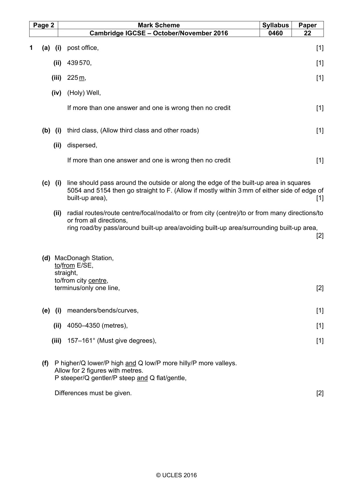
Page 2 Mark Scheme Syllabus Paper Cambridge IGCSE – October/November 2016 0460 22 © UCLES 2016 1 (a) (i) post office, [1] (ii) 439 570, [1] (iii) 225 m, [1] (iv) (Holy) Well, If more than one answer and one is wrong then no credit [1] (b) (i) third class, (Allow third class and other roads) [1] (ii) dispersed, If more than one answer and one is wrong then no credit [1] (c) (i) line should pass around the outside or along the edge of the built-up area in squares 5054 and 5154 then go straight to F. (Allow if mostly within 3 mm of either side of edge of built-up area), [1] (ii) radial routes/route centre/focal/nodal/to or from city (centre)/to or from many directions/to or from all directions, ring road/by pass/around built-up area/avoiding built-up area/surrounding built-up area, [2] (d) MacDonagh Station, to/from E/SE, straight, to/from city centre, terminus/only one line, [2] (e) (i) meanders/bends/curves, [1] (ii) 4050–4350 (metres), [1] (iii) 157–161° (Must give degrees), [1] (f) P higher/Q lower/P high and Q low/P more hilly/P more valleys. Allow for 2 figures with metres. P steeper/Q gentler/P steep and Q flat/gentle, Differences must be given. [2]
Mark scheme, page 3
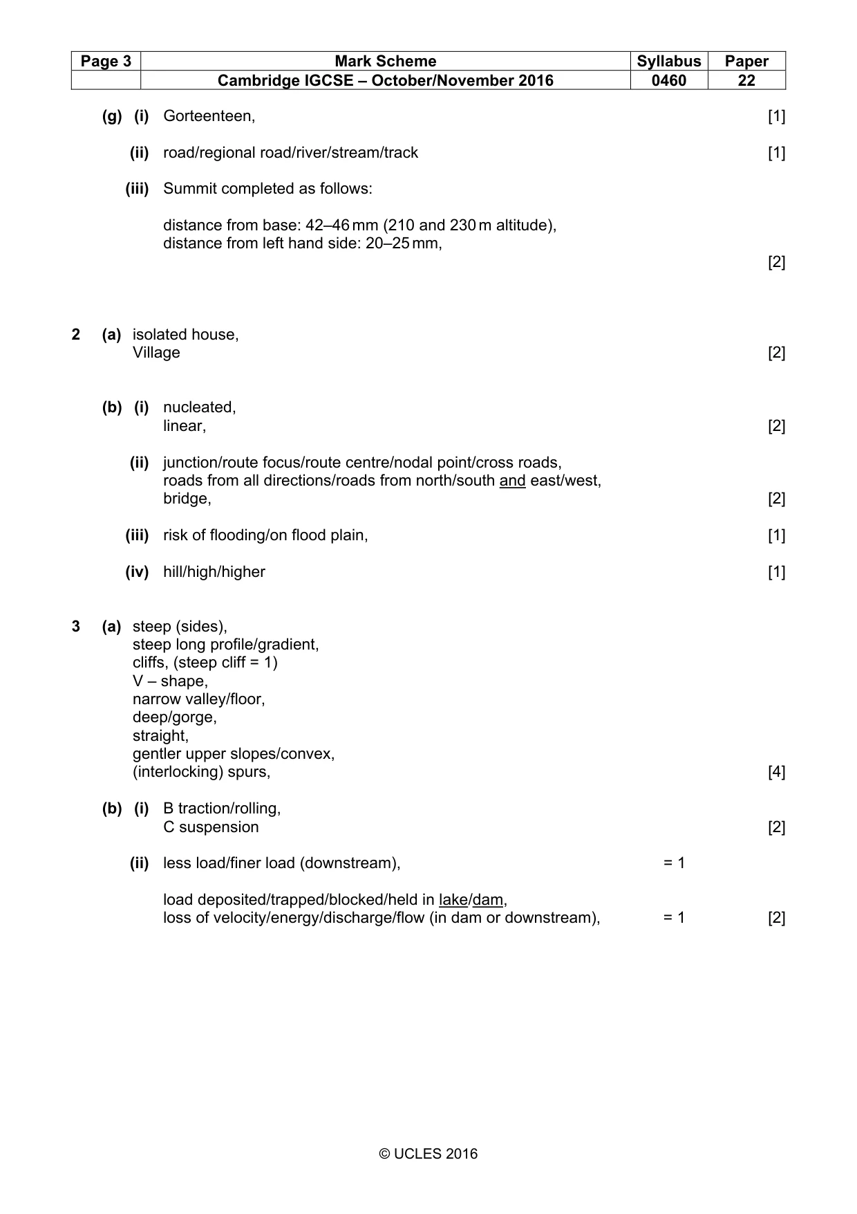
Page 3 Mark Scheme Syllabus Paper Cambridge IGCSE – October/November 2016 0460 22 © UCLES 2016 (g) (i) Gorteenteen, [1] (ii) road/regional road/river/stream/track [1] (iii) Summit completed as follows: distance from base: 42–46 mm (210 and 230 m altitude), distance from left hand side: 20–25 mm, [2] 2 (a) isolated house, Village [2] (b) (i) nucleated, linear, [2] (ii) junction/route focus/route centre/nodal point/cross roads, roads from all directions/roads from north/south and east/west, bridge, [2] (iii) risk of flooding/on flood plain, [1] (iv) hill/high/higher [1] 3 (a) steep (sides), steep long profile/gradient, cliffs, (steep cliff = 1) V – shape, narrow valley/floor, deep/gorge, straight, gentler upper slopes/convex, (interlocking) spurs, [4] (b) (i) B traction/rolling, C suspension [2] (ii) less load/finer load (downstream), = 1 load deposited/trapped/blocked/held in lake/dam, loss of velocity/energy/discharge/flow (in dam or downstream), = 1 [2]
Mark scheme, page 4
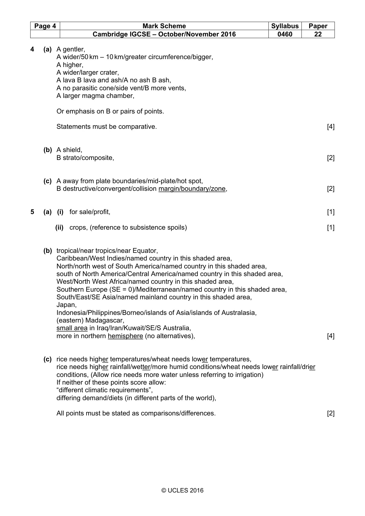
Page 4 Mark Scheme Syllabus Paper Cambridge IGCSE – October/November 2016 0460 22 © UCLES 2016 4 (a) A gentler, A wider/50 km – 10 km/greater circumference/bigger, A higher, A wider/larger crater, A lava B lava and ash/A no ash B ash, A no parasitic cone/side vent/B more vents, A larger magma chamber, Or emphasis on B or pairs of points. Statements must be comparative. [4] (b) A shield, B strato/composite, [2] (c) A away from plate boundaries/mid-plate/hot spot, B destructive/convergent/collision margin/boundary/zone, [2] 5 (a) (i) for sale/profit, [1] (ii) crops, (reference to subsistence spoils) [1] (b) tropical/near tropics/near Equator, Caribbean/West Indies/named country in this shaded area, North/north west of South America/named country in this shaded area, south of North America/Central America/named country in this shaded area, West/North West Africa/named country in this shaded area, Southern Europe (SE = 0)/Mediterranean/named country in this shaded area, South/East/SE Asia/named mainland country in this shaded area, Japan, Indonesia/Philippines/Borneo/islands of Asia/islands of Australasia, (eastern) Madagascar, small area in Iraq/Iran/Kuwait/SE/S Australia, more in northern hemisphere (no alternatives), [4] (c) rice needs higher temperatures/wheat needs lower temperatures, rice needs higher rainfall/wetter/more humid conditions/wheat needs lower rainfall/drier conditions, (Allow rice needs more water unless referring to irrigation) If neither of these points score allow: “different climatic requirements”, differing demand/diets (in different parts of the world), All points must be stated as comparisons/differences. [2]
Mark scheme, page 5
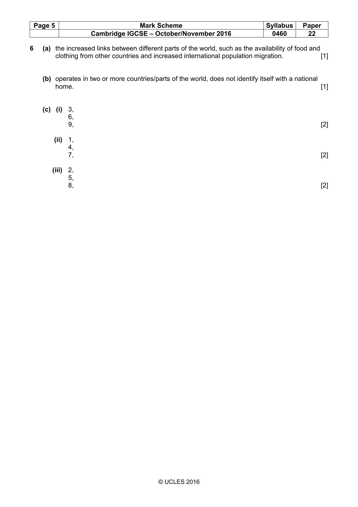
Page 5 Mark Scheme Syllabus Paper Cambridge IGCSE – October/November 2016 0460 22 © UCLES 2016 6 (a) the increased links between different parts of the world, such as the availability of food and clothing from other countries and increased international population migration. [1] (b) operates in two or more countries/parts of the world, does not identify itself with a national home. [1] (c) (i) 3, 6, 9, [2] (ii) 1, 4, 7, [2] (iii) 2, 5, 8, [2]
What you needed in this session
Cambridge’s own grade thresholds for 2016 Oct/Nov, Paper 2 · Variant 2. A higher threshold means an easier paper — the bar moves with how the cohort did.