Cambridge IGCSE Geography 0460 — 2017 Oct/Nov Paper 1 · Variant 1
0460/11/O/N/17 · 75 marks · ≈84 min
The question paper and its mark scheme, free to read here and free to download. This is Cambridge’s own paper, exactly as it was sat.
Question paper32 pages




Mark scheme16 pages
Answers below. Sit the paper first if you are practising.
Paper as text
Question paper, page 1
This document consists of 29 printed pages, 3 blank pages and 1 Insert. DC (ST/SG) 132672/3 © UCLES 2017 [Turn over Cambridge International Examinations Cambridge International General Certificate of Secondary Education * 1 8 6 9 9 9 9 6 0 5 * GEOGRAPHY 0460/11 Paper 1 October/November 2017 1 hour 45 minutes Candidates answer on the Question Paper. Additional Materials: Ruler Calculator READ THESE INSTRUCTIONS FIRST Write your Centre number, candidate number and name in the spaces provided. Write in dark blue or black pen. You may use an HB pencil for any diagrams or graphs. Do not use staples, paper clips, glue or correction fluid. DO NOT WRITE IN ANY BARCODES. Write your answer to each question in the space provided. If additional space is required, you should use the lined pages at the end of this booklet. The question number(s) must be clearly shown. Answer three questions, one from each section. The Insert contains Fig. 1 for Question 1, Photographs A, B, C and D for Question 5, and Photograph E for Question 6. The Insert is not required by the Examiner. Sketch maps and diagrams should be drawn whenever they serve to illustrate an answer. At the end of the examination, fasten all your work securely together. The number of marks is given in brackets [ ] at the end of each question or part question. Definitions MEDCs – More Economically Developed Countries LEDCs – Less Economically Developed Countries The syllabus is approved for use in England, Wales and Northern Ireland as a Cambridge International Level 1/Level 2 Certificate.
Question paper, page 2
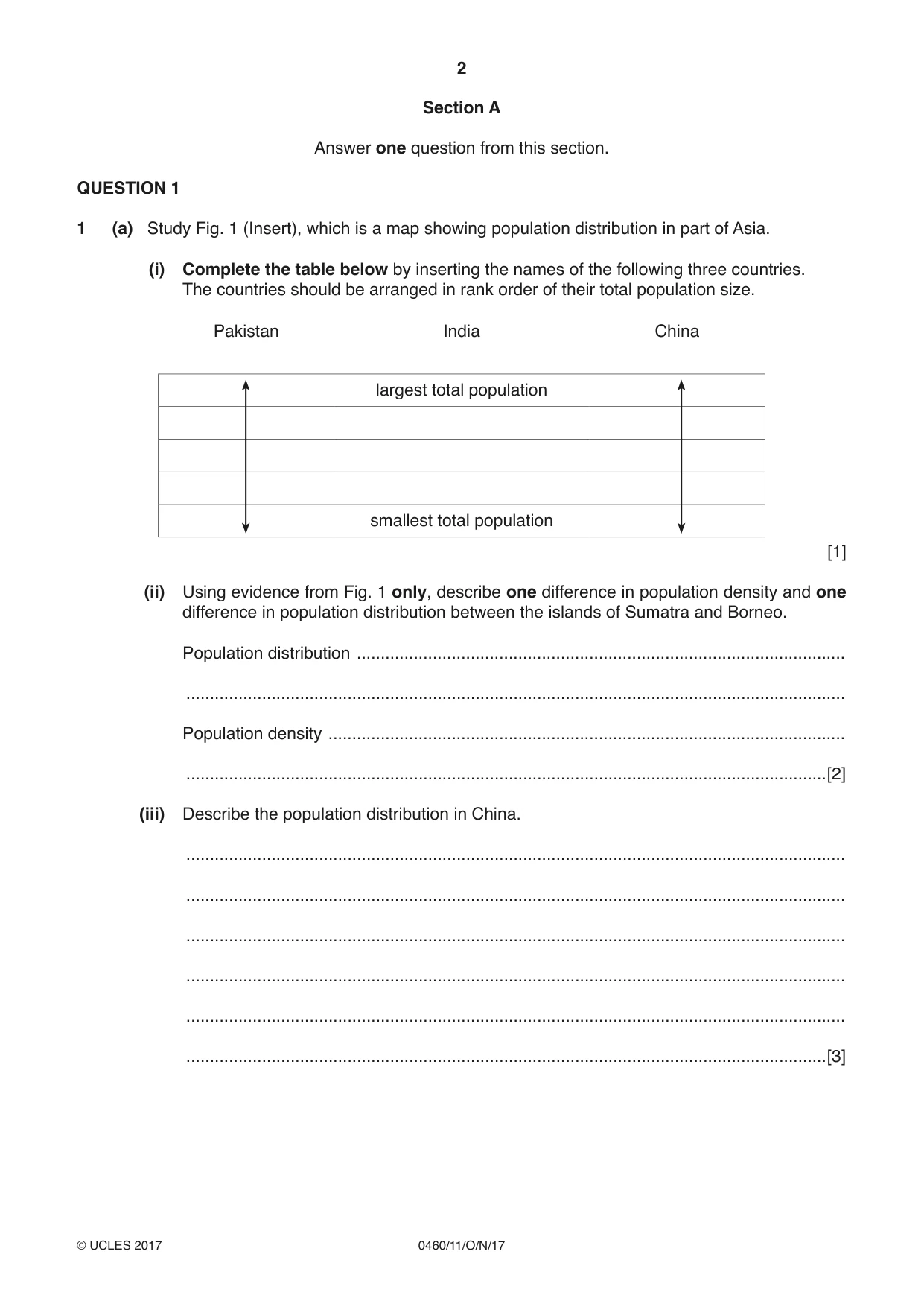
2 0460/11/O/N/17 © UCLES 2017 Section A Answer one question from this section. QUESTION 1 1 (a) Study Fig. 1 (Insert), which is a map showing population distribution in part of Asia. (i) Complete the table below by inserting the names of the following three countries. The countries should be arranged in rank order of their total population size. Pakistan India China largest total population smallest total population [1] (ii) Using evidence from Fig. 1 only, describe one difference in population density and one difference in population distribution between the islands of Sumatra and Borneo. Population distribution … … Population density … …[2] (iii) Describe the population distribution in China. … … … … … …[3]
Question paper, page 3
3 0460/11/O/N/17 © UCLES 2017 [Turn over (iv) Suggest reasons for the low population density in Mongolia. … … … … … … … …[4]
Question paper, page 4
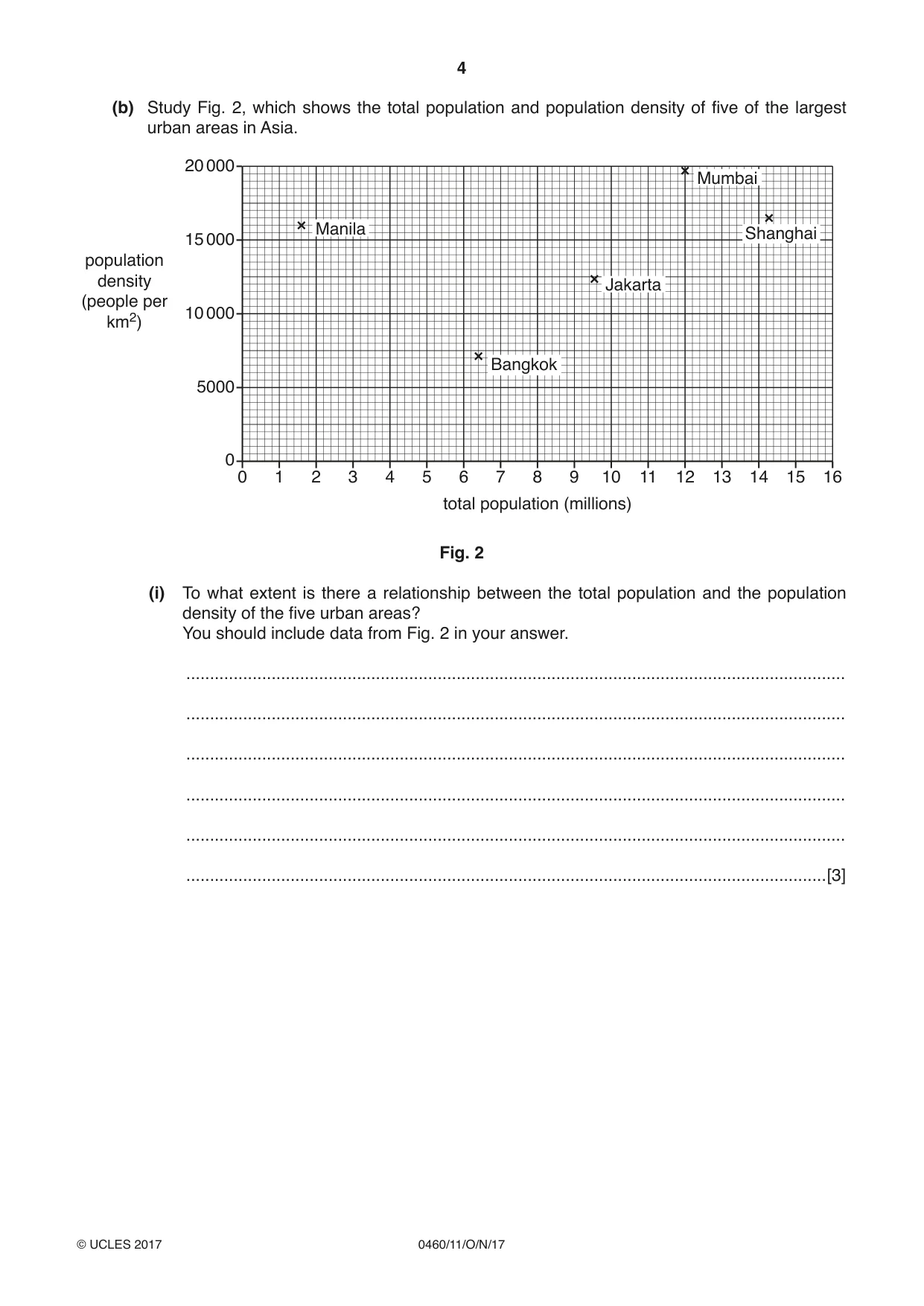
4 0460/11/O/N/17 © UCLES 2017 (b) Study Fig. 2, which shows the total population and population density of five of the largest urban areas in Asia. 20 000 15 000 10 000 5000 0 0 1 2 3 4 5 6 7 8 9 10 11 12 13 14 15 16 total population (millions) population density (people per km2) Manila Jakarta Mumbai Bangkok Shanghai Fig. 2 (i) To what extent is there a relationship between the total population and the population density of the five urban areas? You should include data from Fig. 2 in your answer. … … … … … …[3]
Question paper, page 5
5 0460/11/O/N/17 © UCLES 2017 [Turn over (ii) Suggest the likely difficulties which planners and city authorities face in urban areas with very high population densities. … … … … … … … … … …[5]
Question paper, page 6
6 0460/11/O/N/17 © UCLES 2017 (c) Name a country you have studied and give reasons why people have migrated from it to another named country. International migration from … to … … … … … … … … … … … … … … … … … … … … … … … … …[7] [Total: 25 marks] END OF QUESTION 1
Question paper, page 7
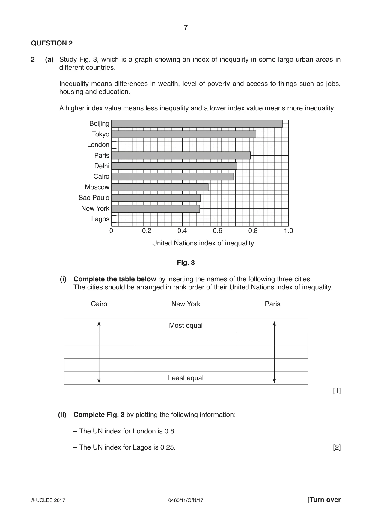
7 0460/11/O/N/17 © UCLES 2017 [Turn over QUESTION 2 2 (a) Study Fig. 3, which is a graph showing an index of inequality in some large urban areas in different countries. Inequality means differences in wealth, level of poverty and access to things such as jobs, housing and education. A higher index value means less inequality and a lower index value means more inequality. Beijing Tokyo London Paris Delhi Cairo Moscow Sao Paulo New York Lagos 0 0.2 0.4 0.6 0.8 1.0 United Nations index of inequality Fig. 3 (i) Complete the table below by inserting the names of the following three cities. The cities should be arranged in rank order of their United Nations index of inequality. Cairo New York Paris Most equal Least equal [1] (ii) Complete Fig. 3 by plotting the following information: – The UN index for London is 0.8. – The UN index for Lagos is 0.25. [2]
Question paper, page 8
8 0460/11/O/N/17 © UCLES 2017 (iii) Lagos is the urban area with the highest level of inequality. Suggest three likely problems this will cause. 1 … … 2 … … 3 … …[3] (iv) Explain why, in many cities, there is a high level of inequality. … … … … … … … …[4]
Question paper, page 9
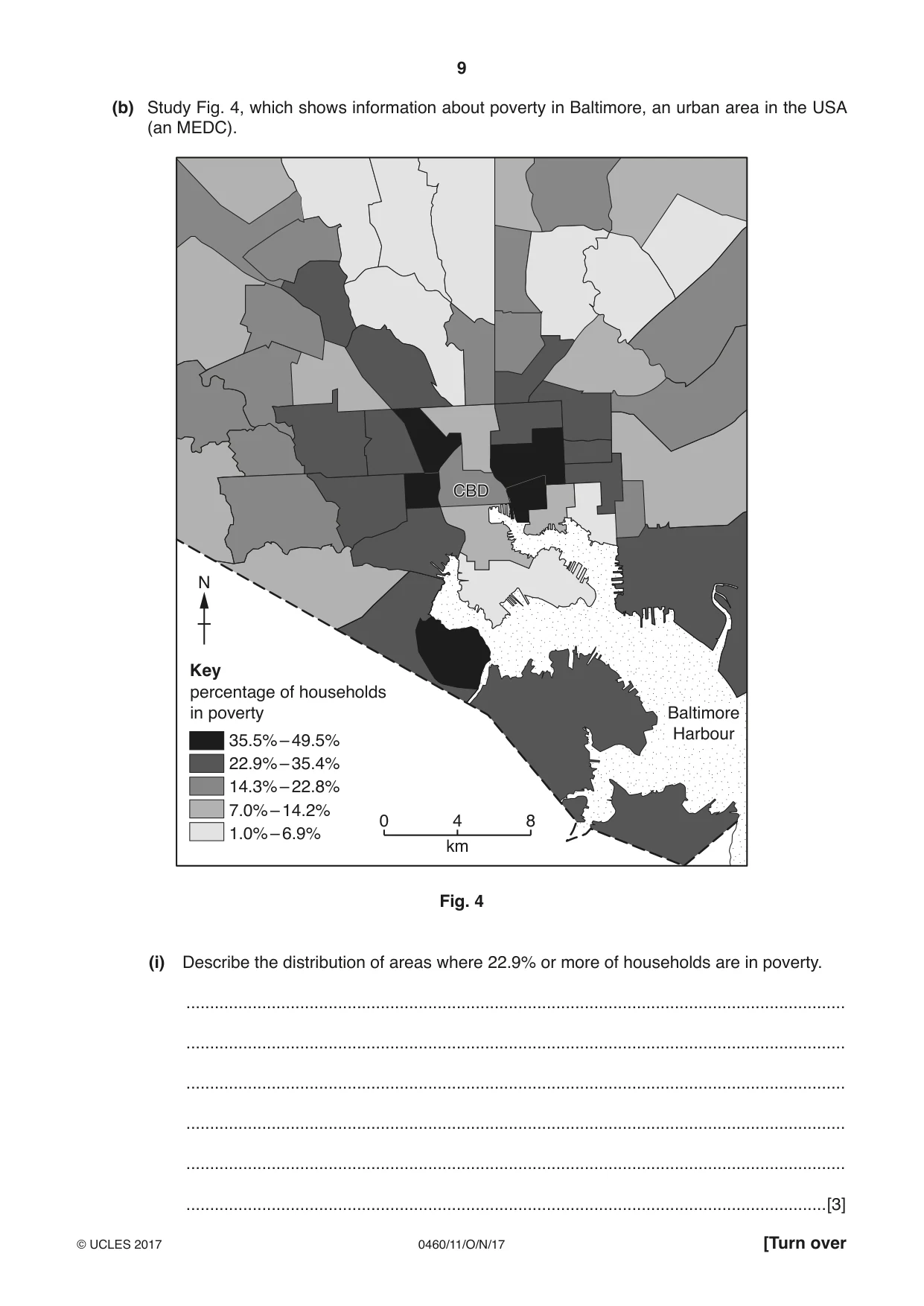
9 0460/11/O/N/17 © UCLES 2017 [Turn over (b) Study Fig. 4, which shows information about poverty in Baltimore, an urban area in the USA (an MEDC). Key percentage of households in poverty N CBD CBD 0 4 km 8 1.0% – 6.9% 7.0% – 14.2% 14.3% – 22.8% 22.9% – 35.4% 35.5% – 49.5% Baltimore Harbour Fig. 4 (i) Describe the distribution of areas where 22.9% or more of households are in poverty. … … … … … …[3]
Question paper, page 10
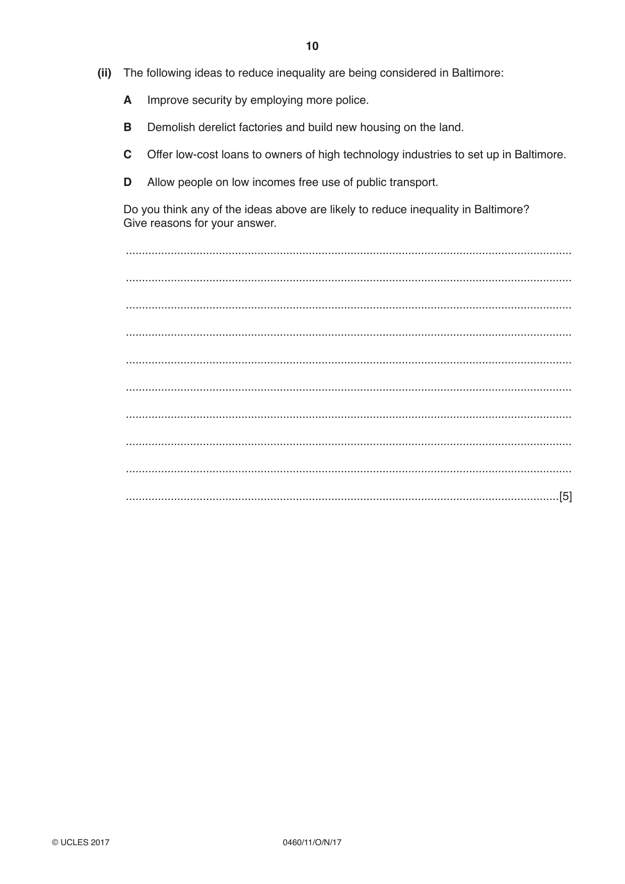
10 0460/11/O/N/17 © UCLES 2017 (ii) The following ideas to reduce inequality are being considered in Baltimore: A Improve security by employing more police. B Demolish derelict factories and build new housing on the land. C Offer low-cost loans to owners of high technology industries to set up in Baltimore. D Allow people on low incomes free use of public transport. Do you think any of the ideas above are likely to reduce inequality in Baltimore? Give reasons for your answer. … … … … … … … … … …[5]
Question paper, page 11
11 0460/11/O/N/17 © UCLES 2017 [Turn over (c) Most urban areas experience traffic problems. For an urban area you have studied, describe the strategies which have been used to reduce traffic congestion. Name of urban area … … … … … … … … … … … … … … … … … … … … … … … …[7] [Total: 25 marks] END OF QUESTION 2
Question paper, page 12
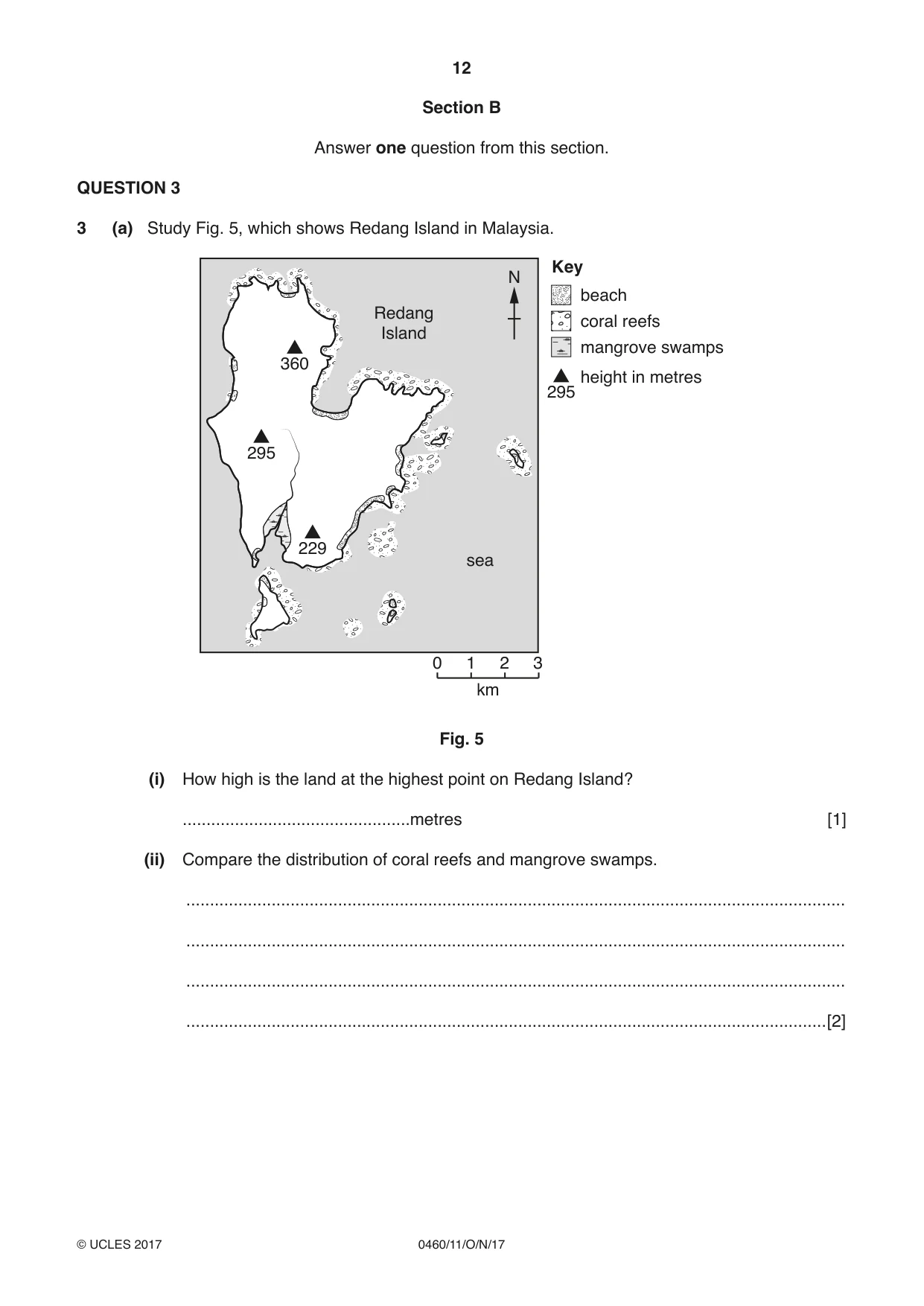
12 0460/11/O/N/17 © UCLES 2017 Section B Answer one question from this section. QUESTION 3 3 (a) Study Fig. 5, which shows Redang Island in Malaysia. km 3 2 1 0 N 295 295 229 360 Redang Island coral reefs mangrove swamps height in metres beach Key sea Fig. 5 (i) How high is the land at the highest point on Redang Island? …metres [1] (ii) Compare the distribution of coral reefs and mangrove swamps. … … … …[2]
Question paper, page 13
13 0460/11/O/N/17 © UCLES 2017 [Turn over (iii) Describe the main characteristics of mangrove swamps. … … … … … …[3] (iv) Describe the conditions required for coral reefs to develop. … … … … … … … …[4]
Question paper, page 14
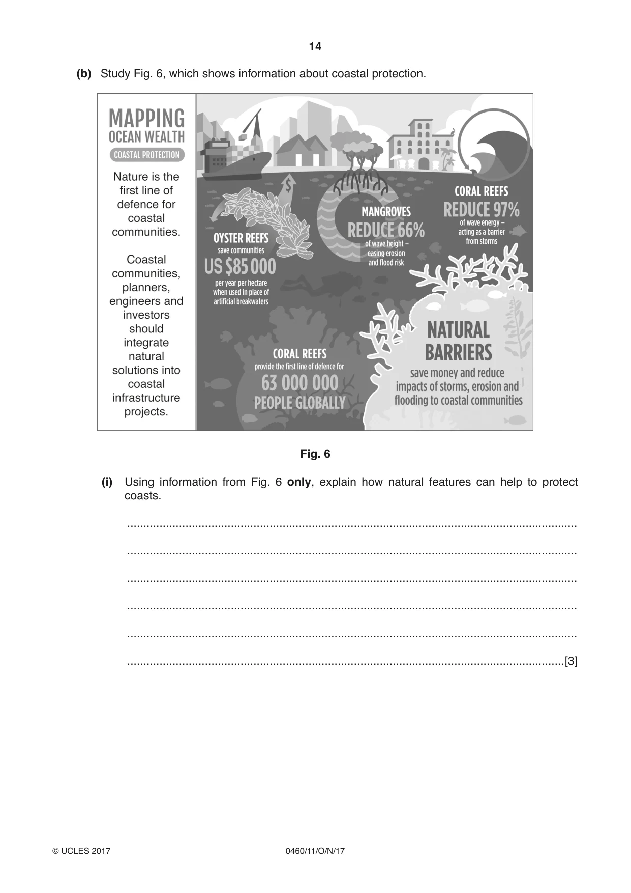
14 0460/11/O/N/17 © UCLES 2017 (b) Study Fig. 6, which shows information about coastal protection. Fig. 6 (i) Using information from Fig. 6 only, explain how natural features can help to protect coasts. … … … … … …[3]
Question paper, page 15
15 0460/11/O/N/17 © UCLES 2017 [Turn over (ii) Describe other methods which can be used to manage coastal erosion. … … … … … … … … … …[5]
Question paper, page 16
16 0460/11/O/N/17 © UCLES 2017 (c) Explain how bays and headlands are formed on a coast. You may use a labelled diagram or diagrams. … … … … … … … … … … … … … … [7] [Total: 25 marks] END OF QUESTION 3
Question paper, page 17
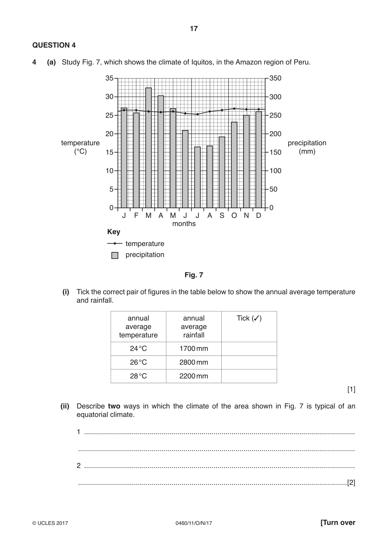
17 0460/11/O/N/17 © UCLES 2017 [Turn over QUESTION 4 4 (a) Study Fig. 7, which shows the climate of Iquitos, in the Amazon region of Peru. 35 30 25 20 15 10 5 0 350 300 250 200 150 100 50 0 J F M A M J J A S O N D months temperature (°C) temperature precipitation (mm) precipitation Key Fig. 7 (i) Tick the correct pair of figures in the table below to show the annual average temperature and rainfall. annual average temperature annual average rainfall Tick (3) 24 °C 1700 mm 26 °C 2800 mm 28 °C 2200 mm [1] (ii) Describe two ways in which the climate of the area shown in Fig. 7 is typical of an equatorial climate. 1 … … 2 … …[2]
Question paper, page 18
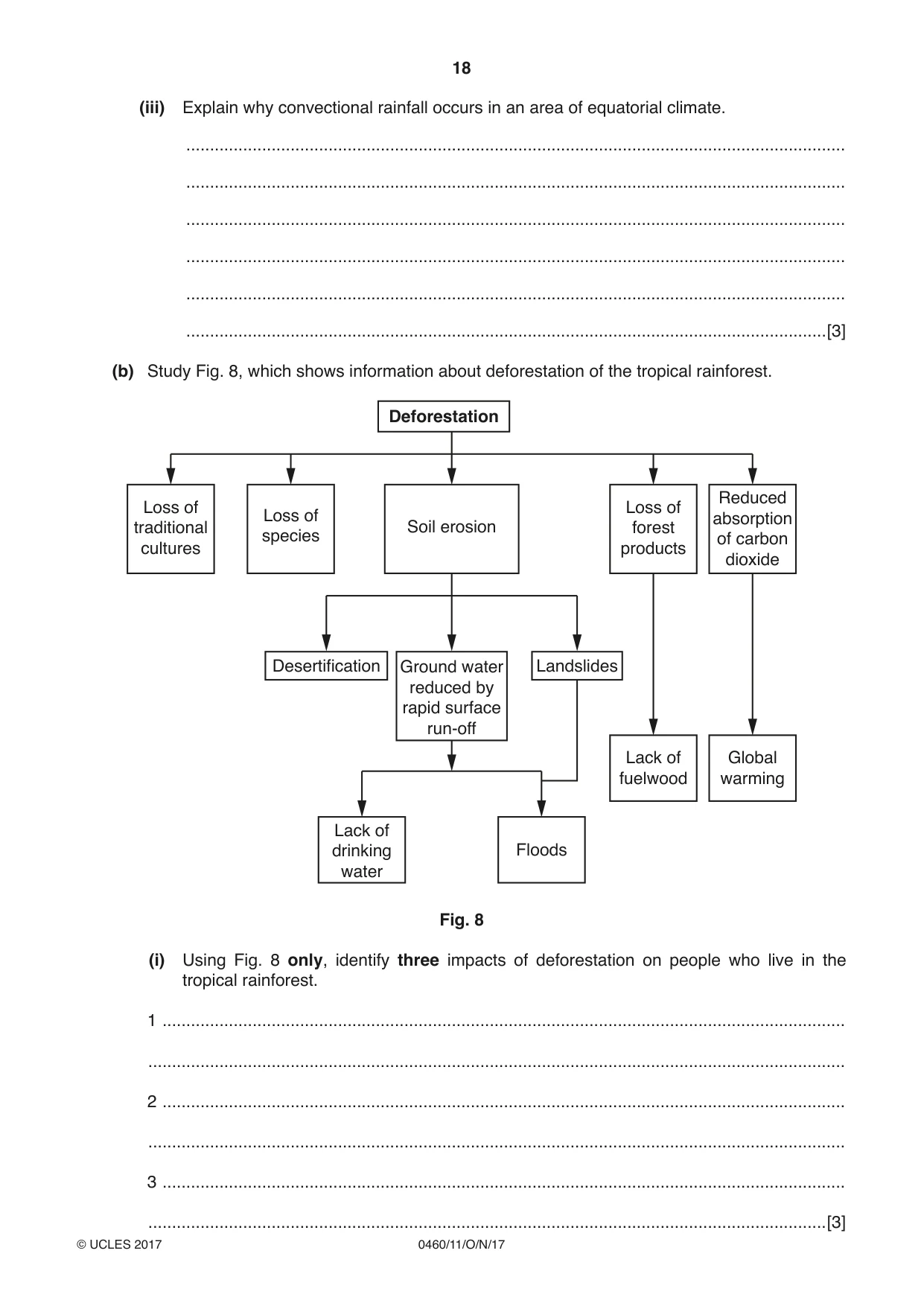
18 0460/11/O/N/17 © UCLES 2017 (iii) Explain why convectional rainfall occurs in an area of equatorial climate. … … … … … …[3] (b) Study Fig. 8, which shows information about deforestation of the tropical rainforest. Deforestation Soil erosion Ground water reduced by rapid surface run-off Loss of forest products Lack of fuelwood Global warming Lack of drinking water Floods Reduced absorption of carbon dioxide Loss of species Loss of traditional cultures Desertification Landslides Fig. 8 (i) Using Fig. 8 only, identify three impacts of deforestation on people who live in the tropical rainforest. 1 … … 2 … … 3 … …[3]
Question paper, page 19
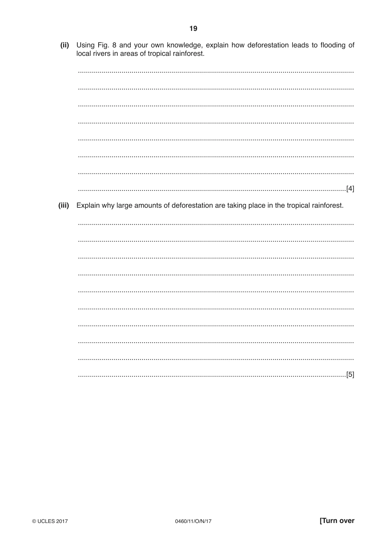
19 0460/11/O/N/17 © UCLES 2017 [Turn over (ii) Using Fig. 8 and your own knowledge, explain how deforestation leads to flooding of local rivers in areas of tropical rainforest. … … … … … … … …[4] (iii) Explain why large amounts of deforestation are taking place in the tropical rainforest. … … … … … … … … … …[5]
Question paper, page 20
20 0460/11/O/N/17 © UCLES 2017 (c) For a named area of desert you have studied, explain why the climate is hot and dry. Name of desert … … … … … … … … … … … … … … … … … … … … … … … … … …[7] [Total: 25 marks] END OF QUESTION 4
Question paper, page 21
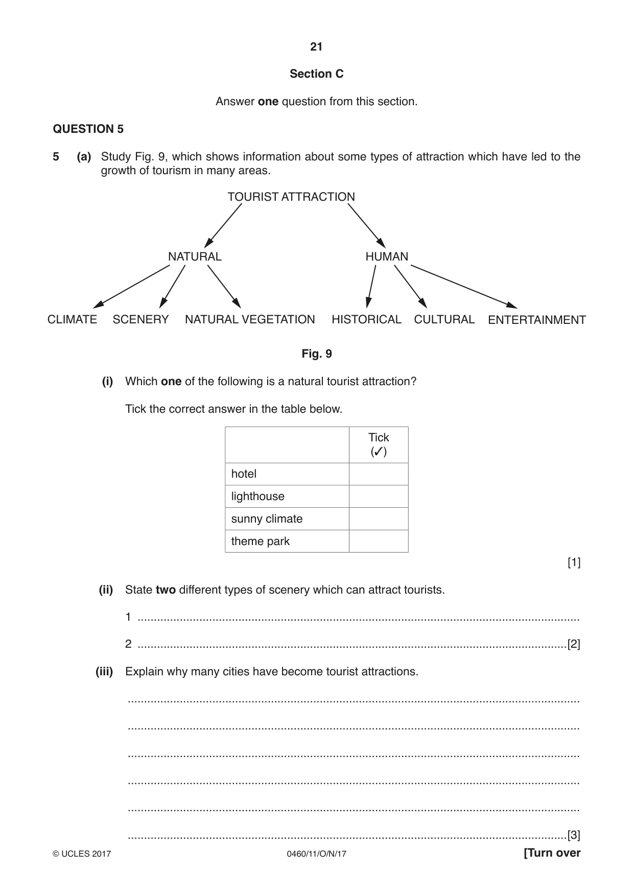
21 0460/11/O/N/17 © UCLES 2017 [Turn over Section C Answer one question from this section. QUESTION 5 5 (a) Study Fig. 9, which shows information about some types of attraction which have led to the growth of tourism in many areas. TOURIST ATTRACTION CLIMATE SCENERY NATURAL VEGETATION NATURAL HUMAN HISTORICAL CULTURAL ENTERTAINMENT Fig. 9 (i) Which one of the following is a natural tourist attraction? Tick the correct answer in the table below. Tick (3) hotel lighthouse sunny climate theme park [1] (ii) State two different types of scenery which can attract tourists. 1 … 2 …[2] (iii) Explain why many cities have become tourist attractions. … … … … … …[3]
Question paper, page 22
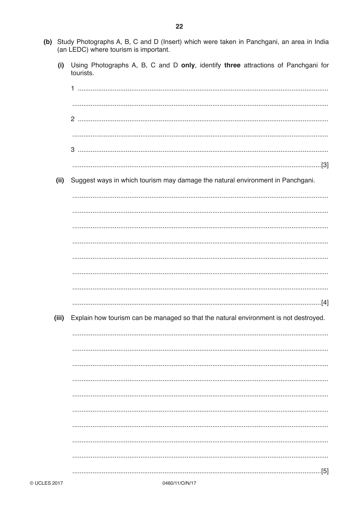
22 0460/11/O/N/17 © UCLES 2017 (b) Study Photographs A, B, C and D (Insert) which were taken in Panchgani, an area in India (an LEDC) where tourism is important. (i) Using Photographs A, B, C and D only, identify three attractions of Panchgani for tourists. 1 … … 2 … … 3 … …[3] (ii) Suggest ways in which tourism may damage the natural environment in Panchgani. … … … … … … … …[4] (iii) Explain how tourism can be managed so that the natural environment is not destroyed. … … … … … … … … … …[5]
Question paper, page 23
23 0460/11/O/N/17 © UCLES 2017 [Turn over (c) For a named area you have studied where tourism is important, explain how it has both positive and negative impacts on local people. Name of area … … … … … … … … … … … … … … … … … … … … … … … … …[7] [Total: 25 marks] END OF QUESTION 5
Question paper, page 24
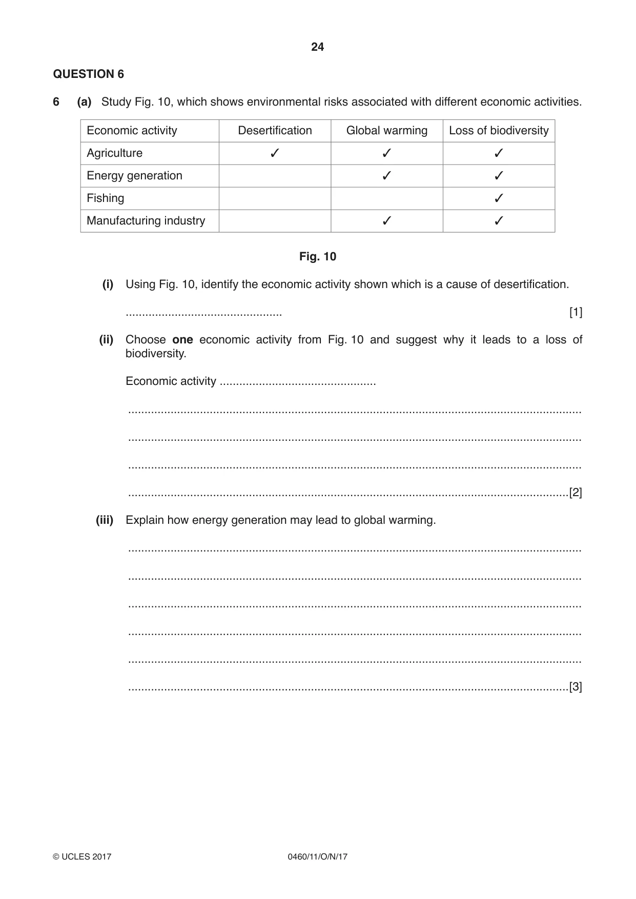
24 0460/11/O/N/17 © UCLES 2017 QUESTION 6 6 (a) Study Fig. 10, which shows environmental risks associated with different economic activities. Economic activity Desertification Global warming Loss of biodiversity Agriculture 3 3 3 Energy generation 3 3 Fishing 3 Manufacturing industry 3 3 Fig. 10 (i) Using Fig. 10, identify the economic activity shown which is a cause of desertification. … [1] (ii) Choose one economic activity from Fig. 10 and suggest why it leads to a loss of biodiversity. Economic activity … … … … …[2] (iii) Explain how energy generation may lead to global warming. … … … … … …[3]
Question paper, page 25
25 0460/11/O/N/17 © UCLES 2017 [Turn over (iv) Explain why global warming is a threat to the natural environment. … … … … … … … …[4]
Question paper, page 26
26 0460/11/O/N/17 © UCLES 2017 (b) Study Photograph E (Insert), which shows an area of soil erosion in Swaziland (an LEDC in Africa). (i) Using evidence from Photograph E only, describe the impacts of soil erosion. … … … … … …[3] (ii) Suggest ways in which both economic activities and natural processes may have caused soil erosion in the area shown in Photograph E. … … … … … … … … … …[5]
Question paper, page 27
27 0460/11/O/N/17 © UCLES 2017 (c) For a named country you have studied, describe the importance of different types of energy. Name of country … … … … … … … … … … … … … … … … … … … … … … … … … …[7] [Total: 25 marks] END OF QUESTION 6
Question paper, page 28
28 0460/11/O/N/17 © UCLES 2017 Additional Pages If you use the following lined pages to complete the answer(s) to any question(s), the question number(s) must be clearly shown. … … … … … … … … … … … … … … … … … … … … … … … … … …
Question paper, page 29
29 0460/11/O/N/17 © UCLES 2017 … … … … … … … … … … … … … … … … … … … … … … … … … … … …
Question paper, page 30
30 0460/11/O/N/17 © UCLES 2017 BLANK PAGE
Question paper, page 31
31 0460/11/O/N/17 © UCLES 2017 BLANK PAGE
Question paper, page 32
32 0460/11/O/N/17 © UCLES 2017 Permission to reproduce items where third-party owned material protected by copyright is included has been sought and cleared where possible. Every reasonable effort has been made by the publisher (UCLES) to trace copyright holders, but if any items requiring clearance have unwittingly been included, the publisher will be pleased to make amends at the earliest possible opportunity. To avoid the issue of disclosure of answer-related information to candidates, all copyright acknowledgements are reproduced online in the Cambridge International Examinations Copyright Acknowledgements Booklet. This is produced for each series of examinations and is freely available to download at www.cie.org.uk after the live examination series. Cambridge International Examinations is part of the Cambridge Assessment Group. Cambridge Assessment is the brand name of University of Cambridge Local Examinations Syndicate (UCLES), which is itself a department of the University of Cambridge. BLANK PAGE
Mark scheme, page 1
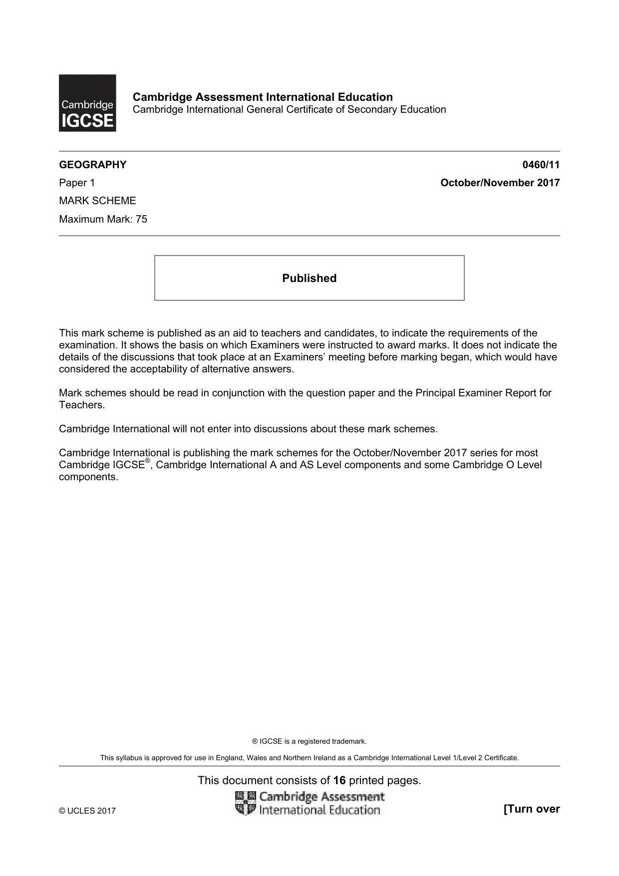
® IGCSE is a registered trademark. This syllabus is approved for use in England, Wales and Northern Ireland as a Cambridge International Level 1/Level 2 Certificate. This document consists of 16 printed pages. © UCLES 2017 [Turn over Cambridge Assessment International Education Cambridge International General Certificate of Secondary Education GEOGRAPHY 0460/11 Paper 1 October/November 2017 MARK SCHEME Maximum Mark: 75 Published This mark scheme is published as an aid to teachers and candidates, to indicate the requirements of the examination. It shows the basis on which Examiners were instructed to award marks. It does not indicate the details of the discussions that took place at an Examiners’ meeting before marking began, which would have considered the acceptability of alternative answers. Mark schemes should be read in conjunction with the question paper and the Principal Examiner Report for Teachers. Cambridge International will not enter into discussions about these mark schemes. Cambridge International is publishing the mark schemes for the October/November 2017 series for most Cambridge IGCSE®, Cambridge International A and AS Level components and some Cambridge O Level components.
Mark scheme, page 2
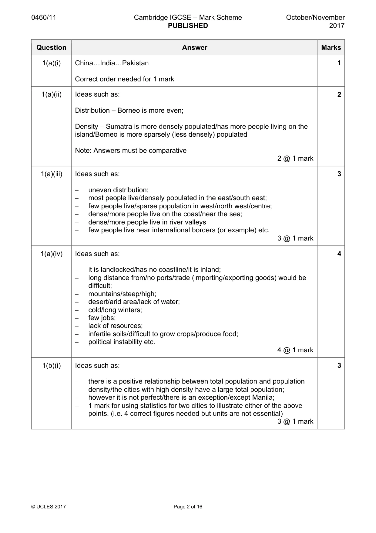
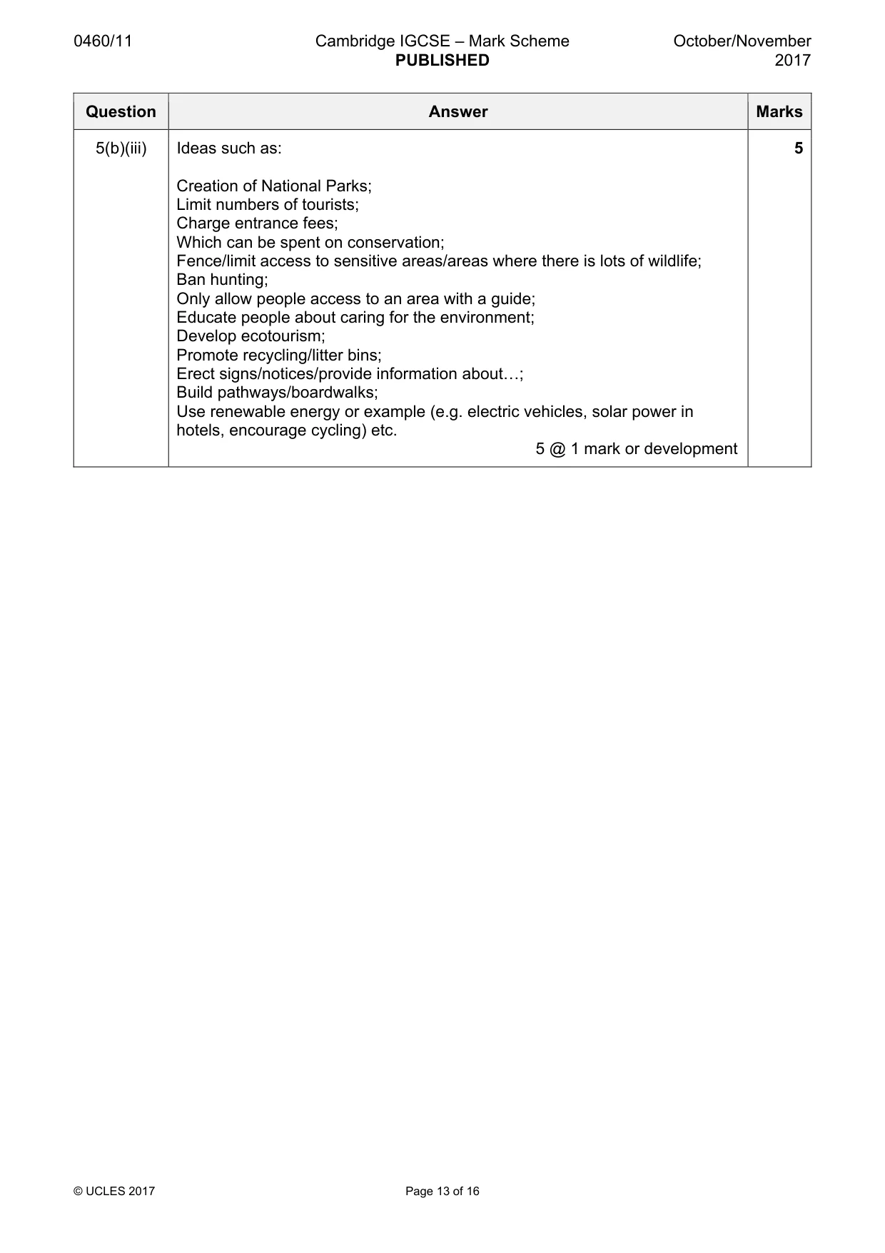
0460/11 Cambridge IGCSE – Mark Scheme PUBLISHED October/November 2017 © UCLES 2017 Page 2 of 16 Question Answer Marks 1(a)(i) China«India«Pakistan Correct order needed for 1 mark 1 1(a)(ii) Ideas such as: Distribution – Borneo is more even; Density – Sumatra is more densely populated/has more people living on the island/Borneo is more sparsely (less densely) populated Note: Answers must be comparative 2 @ 1 mark 2 1(a)(iii) Ideas such as: – uneven distribution; – most people live/densely populated in the east/south east; – few people live/sparse population in west/north west/centre; – dense/more people live on the coast/near the sea; – dense/more people live in river valleys – few people live near international borders (or example) etc. 3 @ 1 mark 3 1(a)(iv) Ideas such as: – it is landlocked/has no coastline/it is inland; – long distance from/no ports/trade (importing/exporting goods) would be difficult; – mountains/steep/high; – desert/arid area/lack of water; – cold/long winters; – few jobs; – lack of resources; – infertile soils/difficult to grow crops/produce food; – political instability etc. 4 @ 1 mark 4 1(b)(i) Ideas such as: – there is a positive relationship between total population and population density/the cities with high density have a large total population; – however it is not perfect/there is an exception/except Manila; – 1 mark for using statistics for two cities to illustrate either of the above points. (i.e. 4 correct figures needed but units are not essential) 3 @ 1 mark 3
Mark scheme, page 3
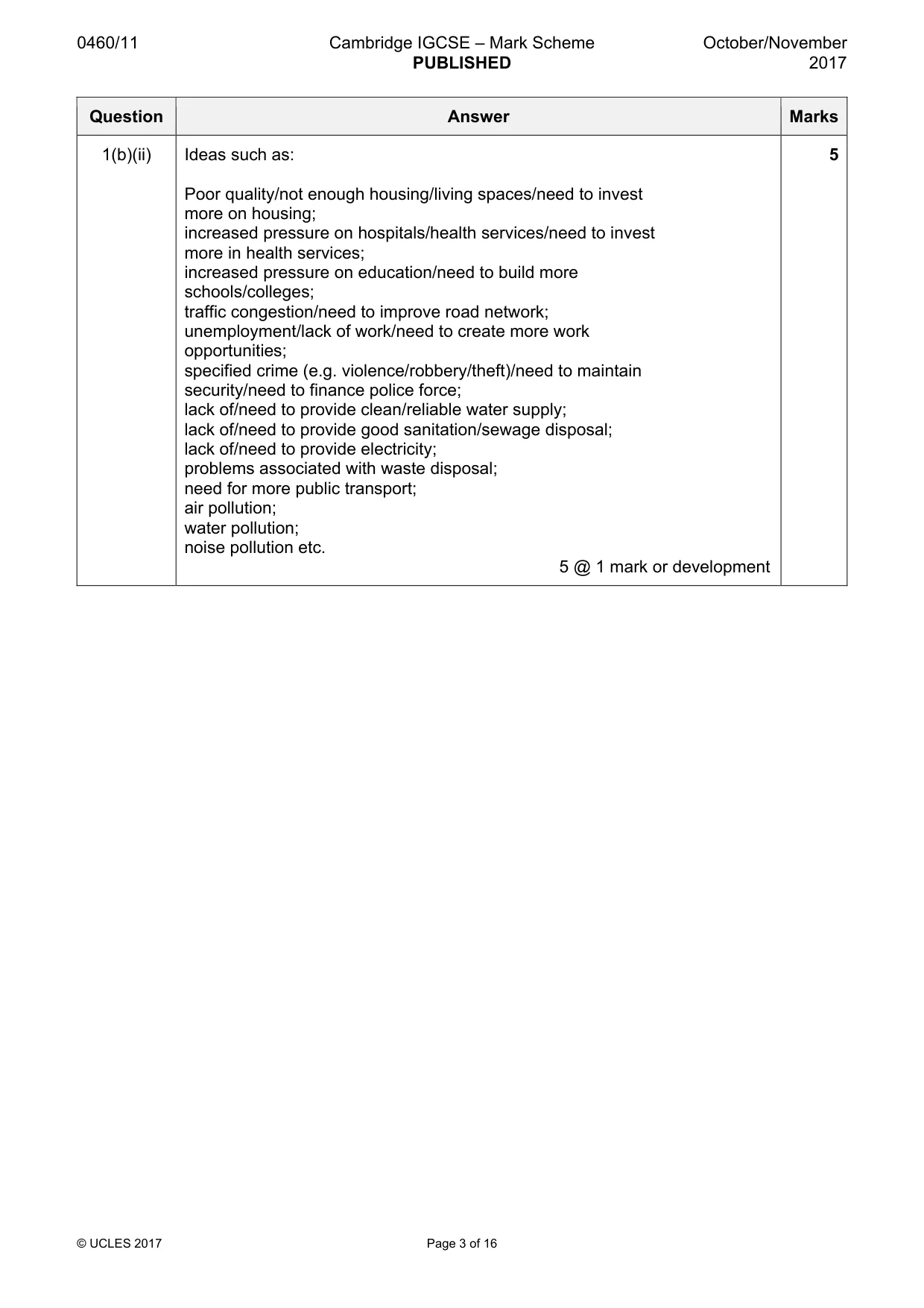
0460/11 Cambridge IGCSE – Mark Scheme PUBLISHED October/November 2017 © UCLES 2017 Page 3 of 16 Question Answer Marks 1(b)(ii) Ideas such as: Poor quality/not enough housing/living spaces/need to invest more on housing; increased pressure on hospitals/health services/need to invest more in health services; increased pressure on education/need to build more schools/colleges; traffic congestion/need to improve road network; unemployment/lack of work/need to create more work opportunities; specified crime (e.g. violence/robbery/theft)/need to maintain security/need to finance police force; lack of/need to provide clean/reliable water supply; lack of/need to provide good sanitation/sewage disposal; lack of/need to provide electricity; problems associated with waste disposal; need for more public transport; air pollution; water pollution; noise pollution etc. 5 @ 1 mark or development 5
Mark scheme, page 4
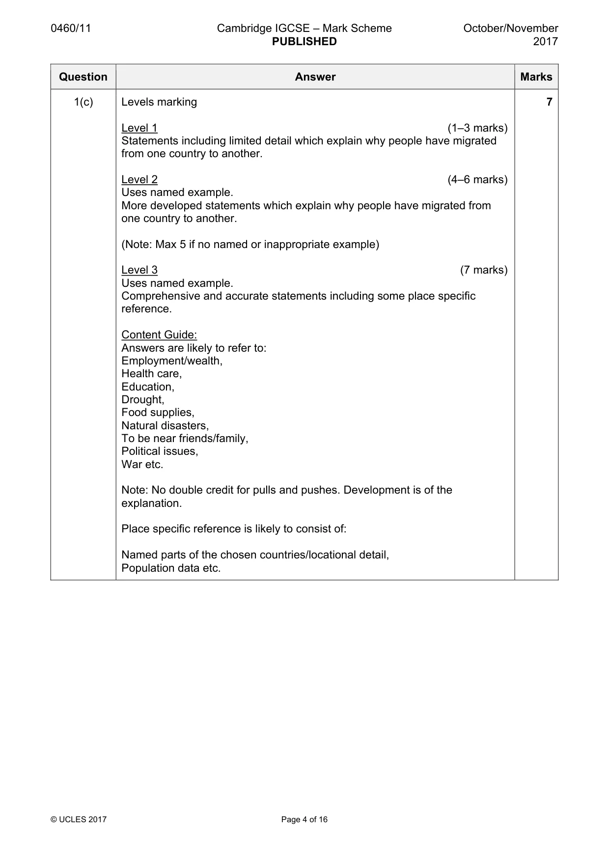
0460/11 Cambridge IGCSE – Mark Scheme PUBLISHED October/November 2017 © UCLES 2017 Page 4 of 16 Question Answer Marks 1(c) Levels marking Level 1 (1–3 marks) Statements including limited detail which explain why people have migrated from one country to another. Level 2 (4–6 marks) Uses named example. More developed statements which explain why people have migrated from one country to another. (Note: Max 5 if no named or inappropriate example) Level 3 (7 marks) Uses named example. Comprehensive and accurate statements including some place specific reference. Content Guide: Answers are likely to refer to: Employment/wealth, Health care, Education, Drought, Food supplies, Natural disasters, To be near friends/family, Political issues, War etc. Note: No double credit for pulls and pushes. Development is of the explanation. Place specific reference is likely to consist of: Named parts of the chosen countries/locational detail, Population data etc. 7
Mark scheme, page 5
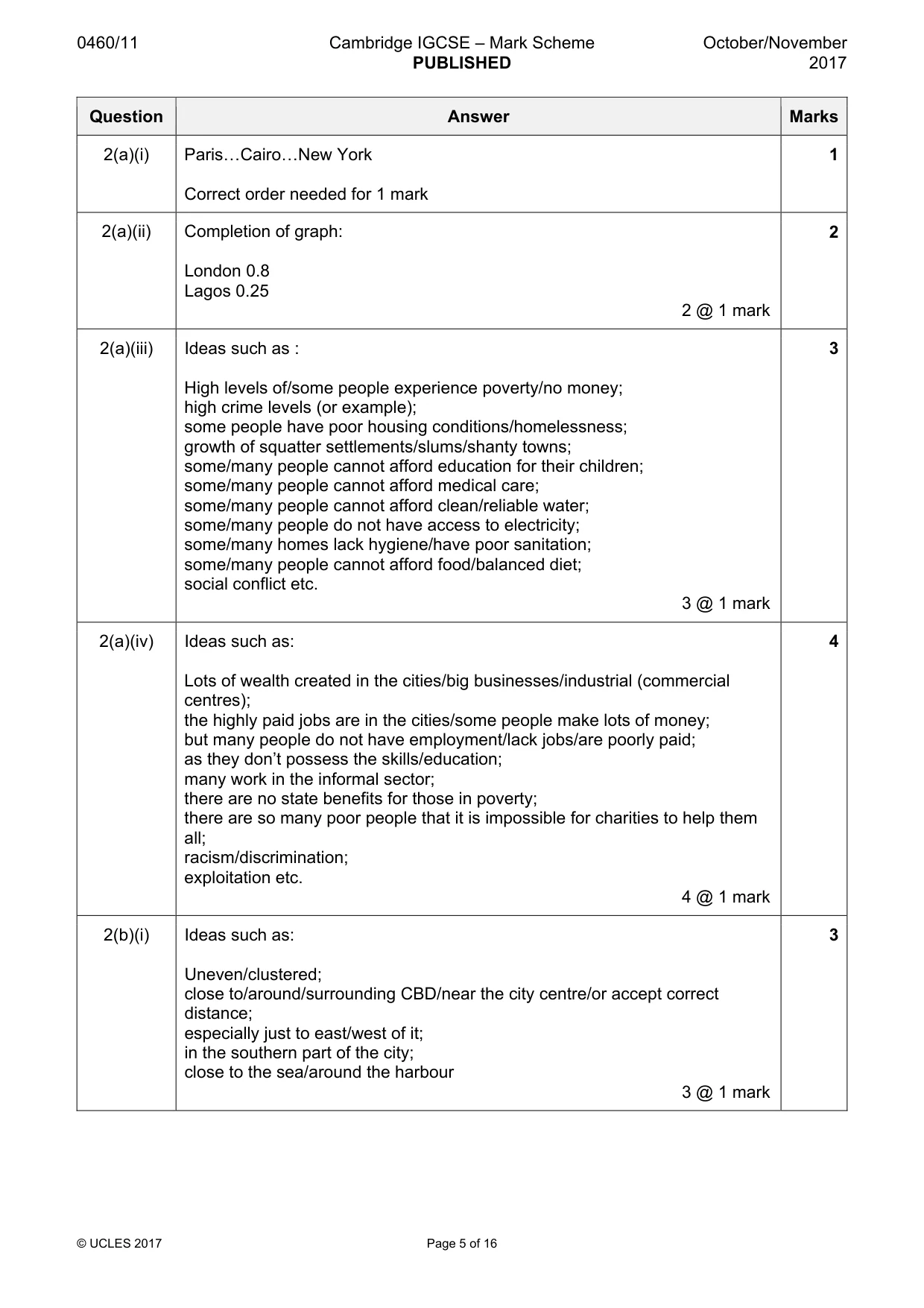
0460/11 Cambridge IGCSE – Mark Scheme PUBLISHED October/November 2017 © UCLES 2017 Page 5 of 16 Question Answer Marks 2(a)(i) Paris«Cairo«New York Correct order needed for 1 mark 1 2(a)(ii) Completion of graph: London 0.8 Lagos 0.25 2 @ 1 mark 2 2(a)(iii) Ideas such as : High levels of/some people experience poverty/no money; high crime levels (or example); some people have poor housing conditions/homelessness; growth of squatter settlements/slums/shanty towns; some/many people cannot afford education for their children; some/many people cannot afford medical care; some/many people cannot afford clean/reliable water; some/many people do not have access to electricity; some/many homes lack hygiene/have poor sanitation; some/many people cannot afford food/balanced diet; social conflict etc. 3 @ 1 mark 3 2(a)(iv) Ideas such as: Lots of wealth created in the cities/big businesses/industrial (commercial centres); the highly paid jobs are in the cities/some people make lots of money; but many people do not have employment/lack jobs/are poorly paid; as they don’t possess the skills/education; many work in the informal sector; there are no state benefits for those in poverty; there are so many poor people that it is impossible for charities to help them all; racism/discrimination; exploitation etc. 4 @ 1 mark 4 2(b)(i) Ideas such as: Uneven/clustered; close to/around/surrounding CBD/near the city centre/or accept correct distance; especially just to east/west of it; in the southern part of the city; close to the sea/around the harbour 3 @ 1 mark 3
Mark scheme, page 6
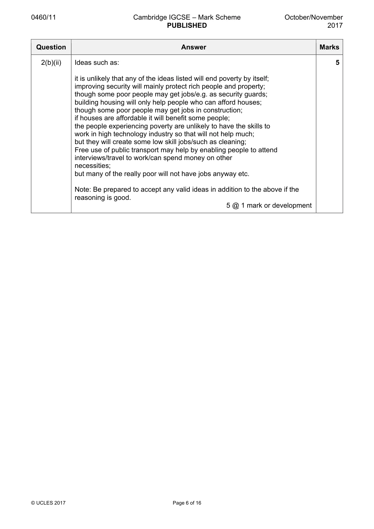
0460/11 Cambridge IGCSE – Mark Scheme PUBLISHED October/November 2017 © UCLES 2017 Page 6 of 16 Question Answer Marks 2(b)(ii) Ideas such as: it is unlikely that any of the ideas listed will end poverty by itself; improving security will mainly protect rich people and property; though some poor people may get jobs/e.g. as security guards; building housing will only help people who can afford houses; though some poor people may get jobs in construction; if houses are affordable it will benefit some people; the people experiencing poverty are unlikely to have the skills to work in high technology industry so that will not help much; but they will create some low skill jobs/such as cleaning; Free use of public transport may help by enabling people to attend interviews/travel to work/can spend money on other necessities; but many of the really poor will not have jobs anyway etc. Note: Be prepared to accept any valid ideas in addition to the above if the reasoning is good. 5 @ 1 mark or development 5
Mark scheme, page 7
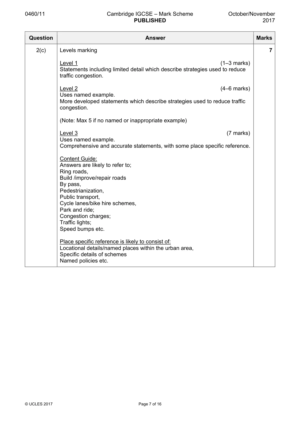
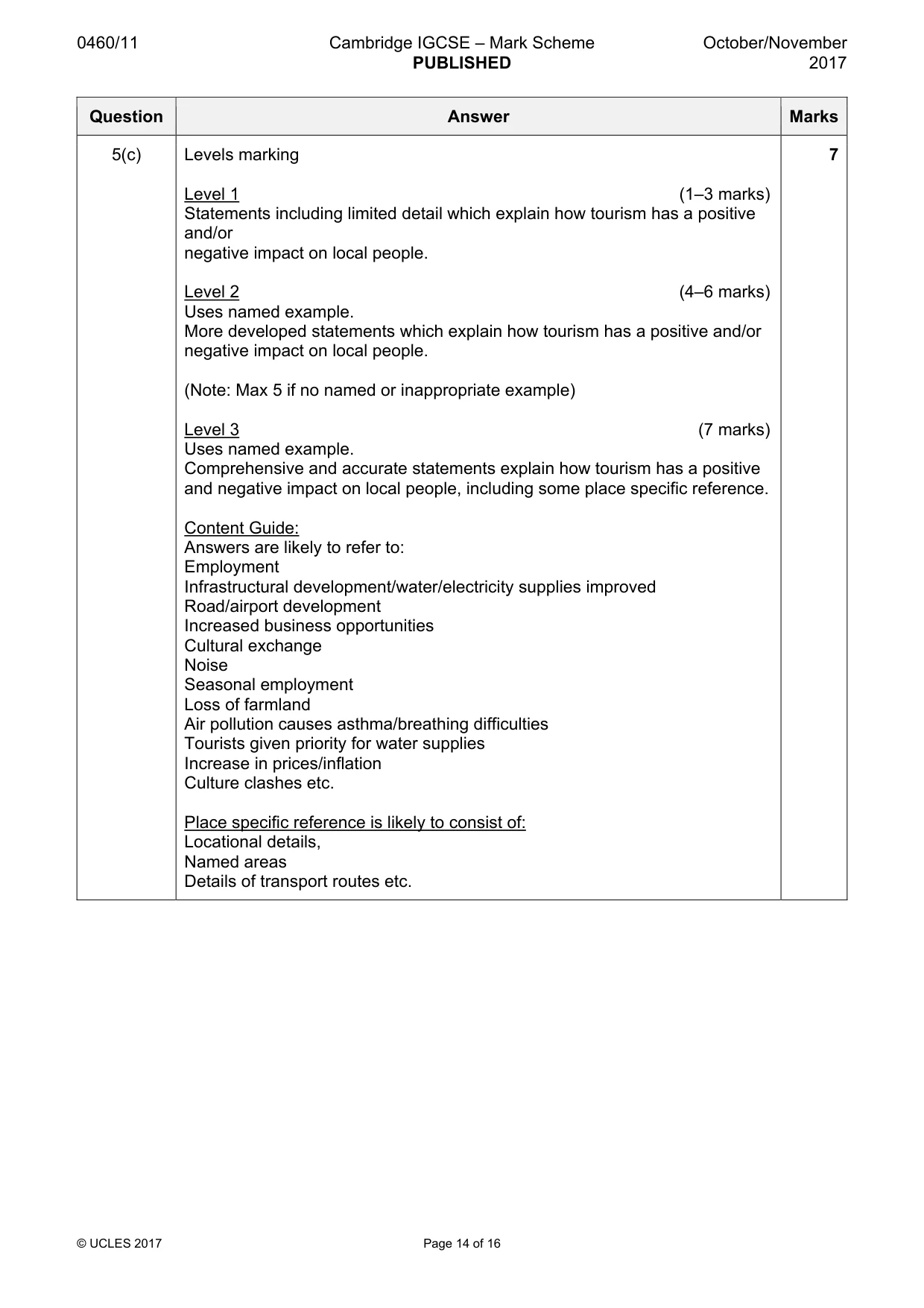
0460/11 Cambridge IGCSE – Mark Scheme PUBLISHED October/November 2017 © UCLES 2017 Page 7 of 16 Question Answer Marks 2(c) Levels marking Level 1 (1–3 marks) Statements including limited detail which describe strategies used to reduce traffic congestion. Level 2 (4–6 marks) Uses named example. More developed statements which describe strategies used to reduce traffic congestion. (Note: Max 5 if no named or inappropriate example) Level 3 (7 marks) Uses named example. Comprehensive and accurate statements, with some place specific reference. Content Guide: Answers are likely to refer to; Ring roads, Build /improve/repair roads By pass, Pedestrianization, Public transport, Cycle lanes/bike hire schemes, Park and ride; Congestion charges; Traffic lights; Speed bumps etc. Place specific reference is likely to consist of: Locational details/named places within the urban area, Specific details of schemes Named policies etc. 7
Mark scheme, page 8
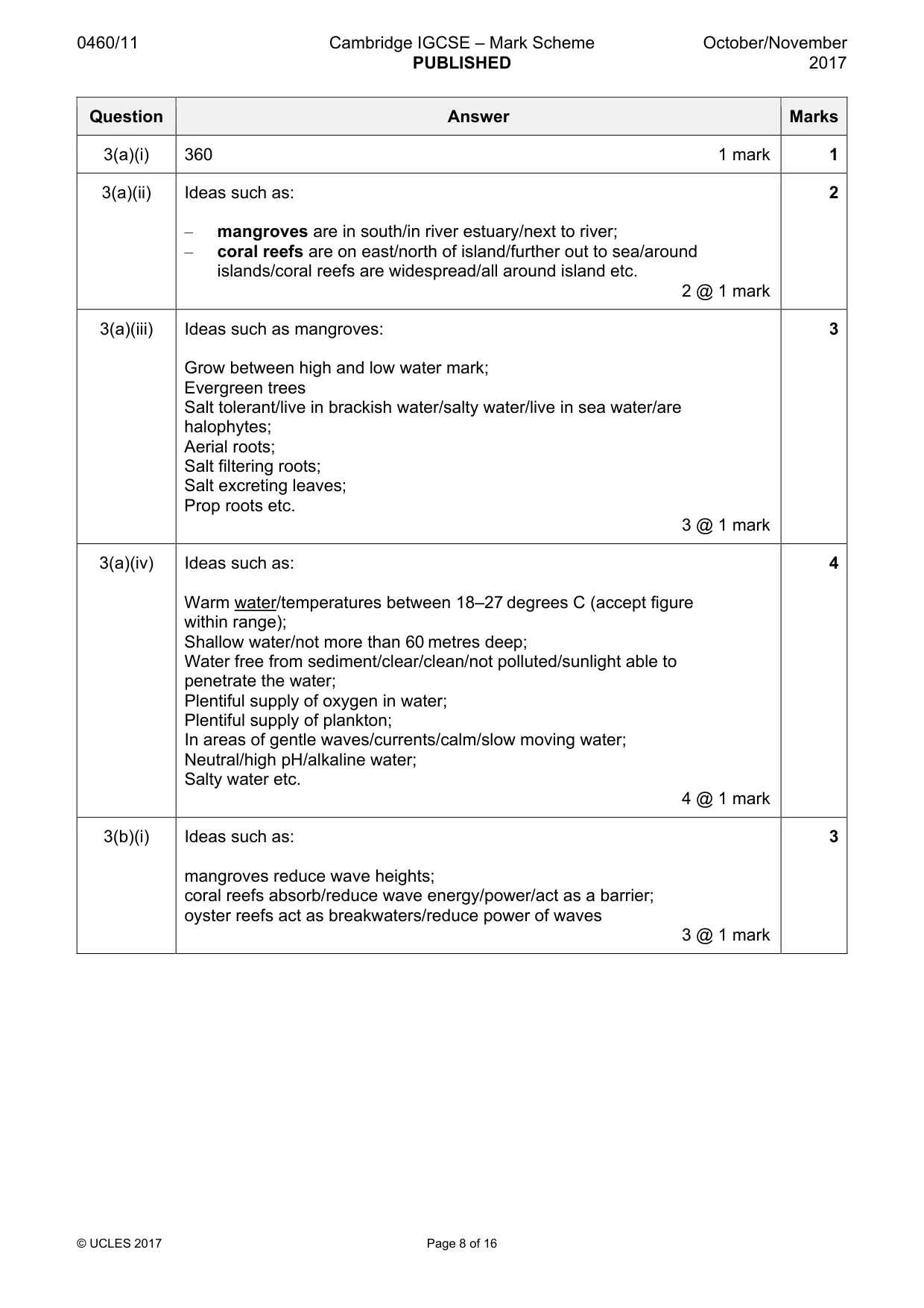
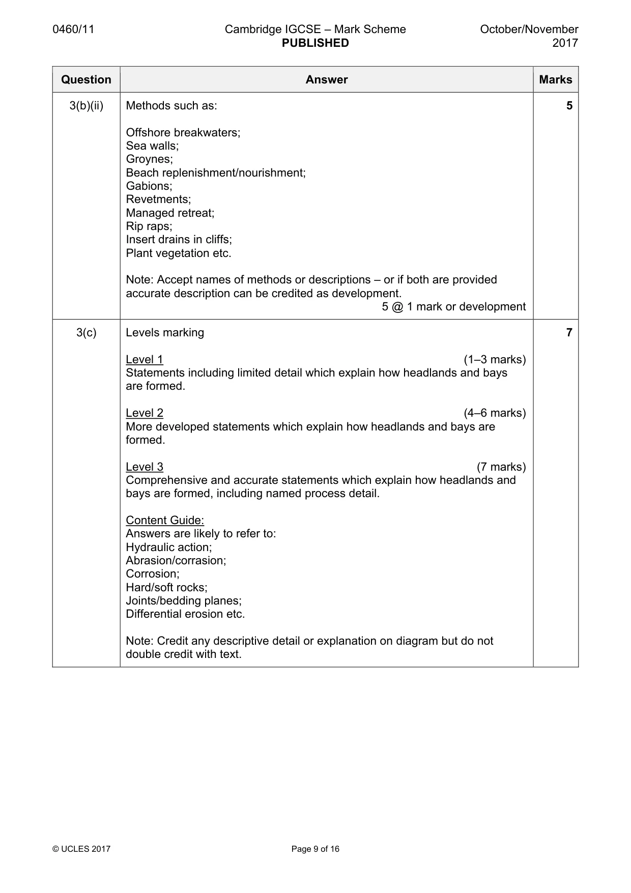
0460/11 Cambridge IGCSE – Mark Scheme PUBLISHED October/November 2017 © UCLES 2017 Page 8 of 16 Question Answer Marks 3(a)(i) 360 1 mark 1 3(a)(ii) Ideas such as: – mangroves are in south/in river estuary/next to river; – coral reefs are on east/north of island/further out to sea/around islands/coral reefs are widespread/all around island etc. 2 @ 1 mark 2 3(a)(iii) Ideas such as mangroves: Grow between high and low water mark; Evergreen trees Salt tolerant/live in brackish water/salty water/live in sea water/are halophytes; Aerial roots; Salt filtering roots; Salt excreting leaves; Prop roots etc. 3 @ 1 mark 3 3(a)(iv) Ideas such as: Warm water/temperatures between 18–27 degrees C (accept figure within range); Shallow water/not more than 60 metres deep; Water free from sediment/clear/clean/not polluted/sunlight able to penetrate the water; Plentiful supply of oxygen in water; Plentiful supply of plankton; In areas of gentle waves/currents/calm/slow moving water; Neutral/high pH/alkaline water; Salty water etc. 4 @ 1 mark 4 3(b)(i) Ideas such as: mangroves reduce wave heights; coral reefs absorb/reduce wave energy/power/act as a barrier; oyster reefs act as breakwaters/reduce power of waves 3 @ 1 mark 3
Mark scheme, page 9
0460/11 Cambridge IGCSE – Mark Scheme PUBLISHED October/November 2017 © UCLES 2017 Page 9 of 16 Question Answer Marks 3(b)(ii) Methods such as: Offshore breakwaters; Sea walls; Groynes; Beach replenishment/nourishment; Gabions; Revetments; Managed retreat; Rip raps; Insert drains in cliffs; Plant vegetation etc. Note: Accept names of methods or descriptions – or if both are provided accurate description can be credited as development. 5 @ 1 mark or development 5 3(c) Levels marking Level 1 (1–3 marks) Statements including limited detail which explain how headlands and bays are formed. Level 2 (4–6 marks) More developed statements which explain how headlands and bays are formed. Level 3 (7 marks) Comprehensive and accurate statements which explain how headlands and bays are formed, including named process detail. Content Guide: Answers are likely to refer to: Hydraulic action; Abrasion/corrasion; Corrosion; Hard/soft rocks; Joints/bedding planes; Differential erosion etc. Note: Credit any descriptive detail or explanation on diagram but do not double credit with text. 7
Mark scheme, page 10
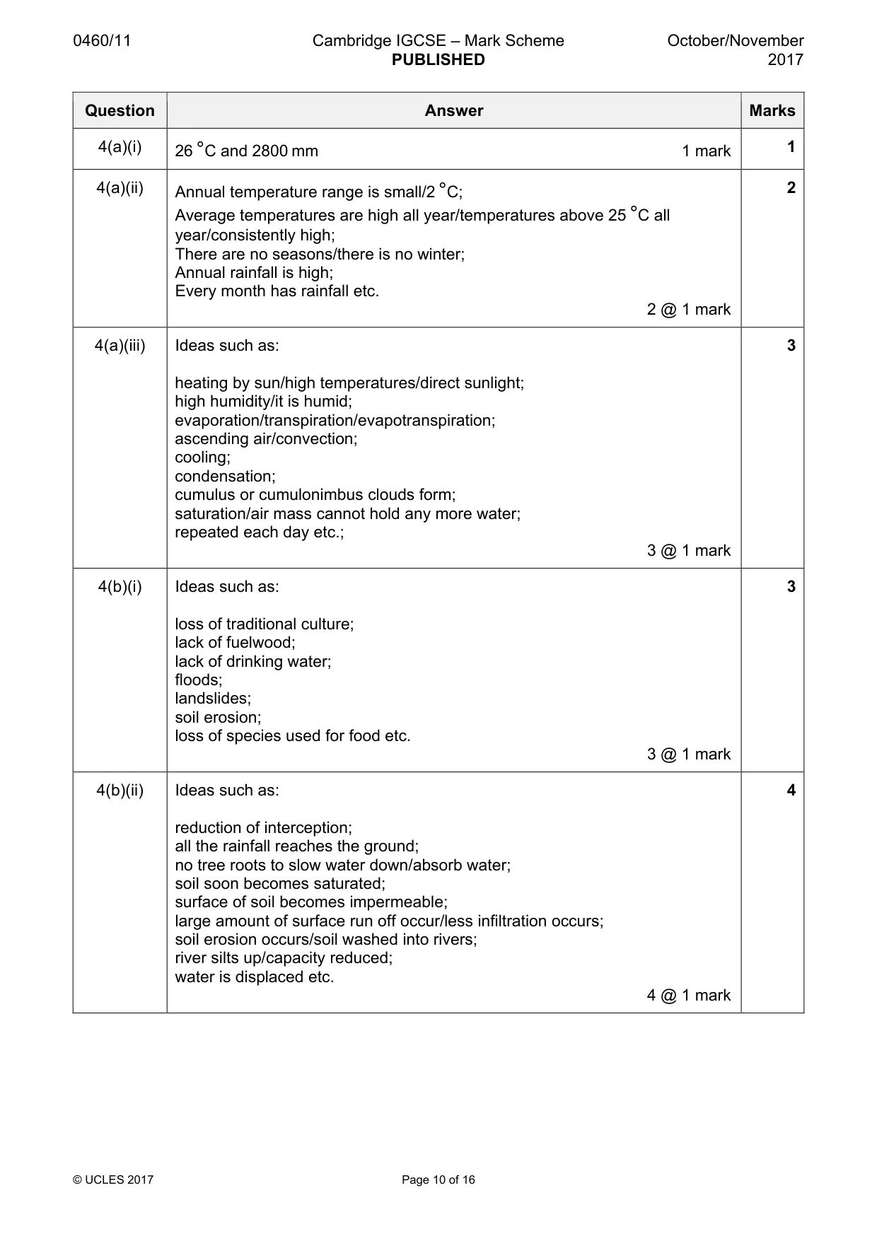
0460/11 Cambridge IGCSE – Mark Scheme PUBLISHED October/November 2017 © UCLES 2017 Page 10 of 16 Question Answer Marks 4(a)(i) 26 °C and 2800 mm 1 mark 1 4(a)(ii) Annual temperature range is small/2 °C; Average temperatures are high all year/temperatures above 25 °C all year/consistently high; There are no seasons/there is no winter; Annual rainfall is high; Every month has rainfall etc. 2 @ 1 mark 2 4(a)(iii) Ideas such as: heating by sun/high temperatures/direct sunlight; high humidity/it is humid; evaporation/transpiration/evapotranspiration; ascending air/convection; cooling; condensation; cumulus or cumulonimbus clouds form; saturation/air mass cannot hold any more water; repeated each day etc.; 3 @ 1 mark 3 4(b)(i) Ideas such as: loss of traditional culture; lack of fuelwood; lack of drinking water; floods; landslides; soil erosion; loss of species used for food etc. 3 @ 1 mark 3 4(b)(ii) Ideas such as: reduction of interception; all the rainfall reaches the ground; no tree roots to slow water down/absorb water; soil soon becomes saturated; surface of soil becomes impermeable; large amount of surface run off occur/less infiltration occurs; soil erosion occurs/soil washed into rivers; river silts up/capacity reduced; water is displaced etc. 4 @ 1 mark 4
Mark scheme, page 11
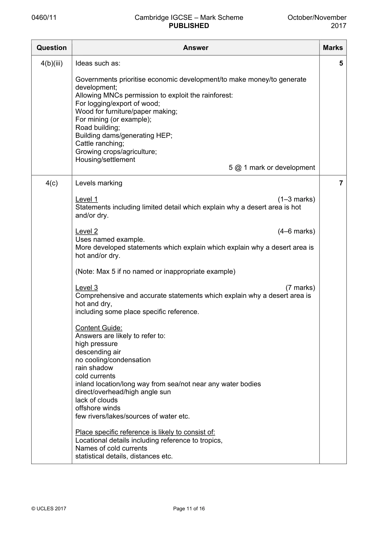
0460/11 Cambridge IGCSE – Mark Scheme PUBLISHED October/November 2017 © UCLES 2017 Page 11 of 16 Question Answer Marks 4(b)(iii) Ideas such as: Governments prioritise economic development/to make money/to generate development; Allowing MNCs permission to exploit the rainforest: For logging/export of wood; Wood for furniture/paper making; For mining (or example); Road building; Building dams/generating HEP; Cattle ranching; Growing crops/agriculture; Housing/settlement 5 @ 1 mark or development 5 4(c) Levels marking Level 1 (1–3 marks) Statements including limited detail which explain why a desert area is hot and/or dry. Level 2 (4–6 marks) Uses named example. More developed statements which explain which explain why a desert area is hot and/or dry. (Note: Max 5 if no named or inappropriate example) Level 3 (7 marks) Comprehensive and accurate statements which explain why a desert area is hot and dry, including some place specific reference. Content Guide: Answers are likely to refer to: high pressure descending air no cooling/condensation rain shadow cold currents inland location/long way from sea/not near any water bodies direct/overhead/high angle sun lack of clouds offshore winds few rivers/lakes/sources of water etc. Place specific reference is likely to consist of: Locational details including reference to tropics, Names of cold currents statistical details, distances etc. 7
Mark scheme, page 12
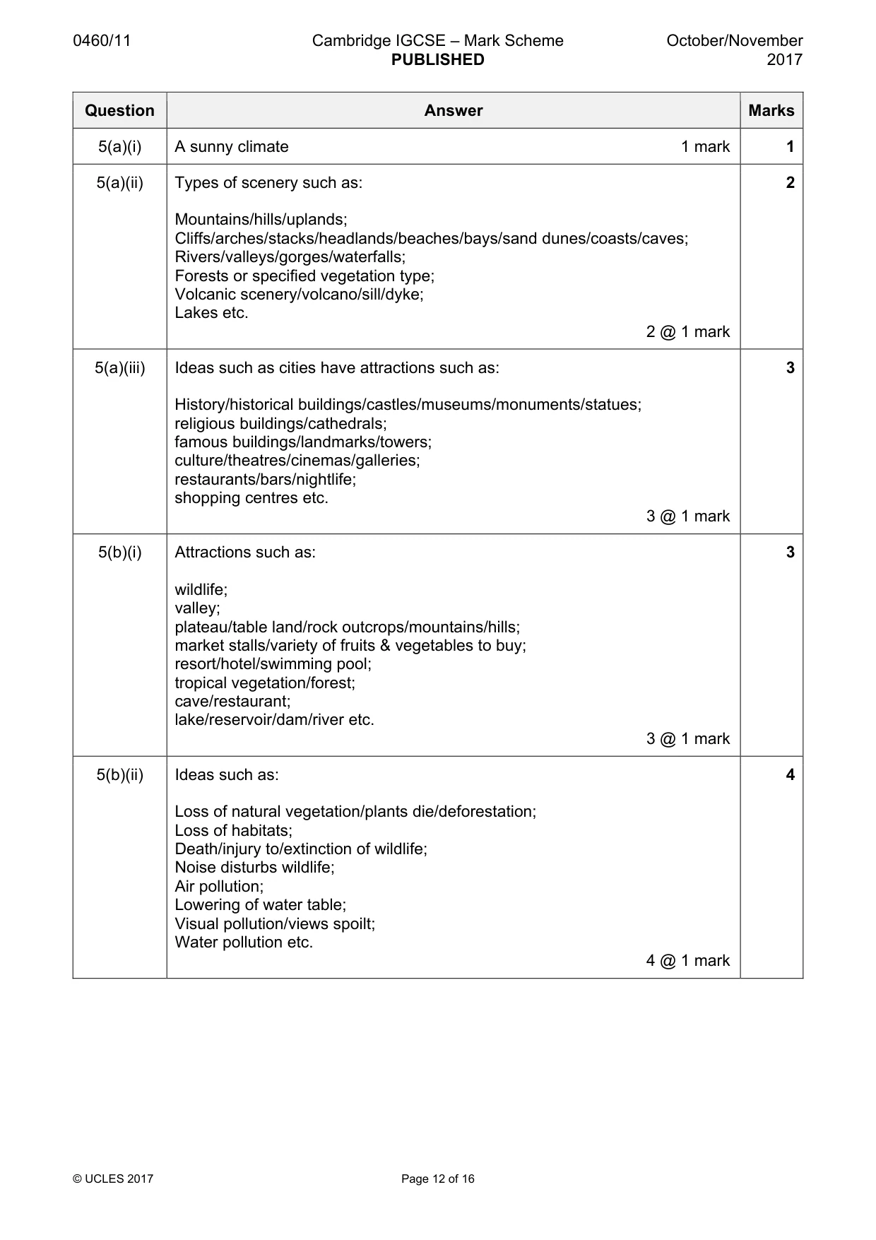
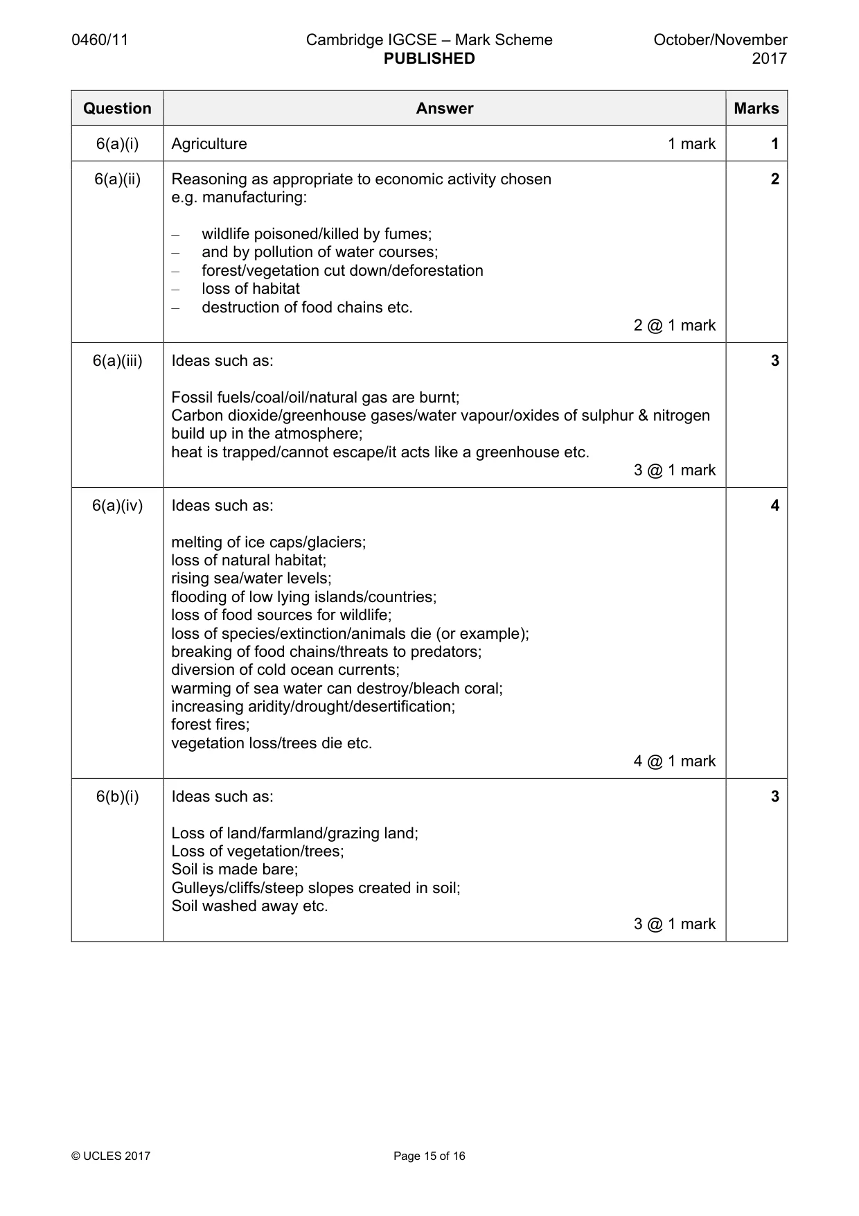
0460/11 Cambridge IGCSE – Mark Scheme PUBLISHED October/November 2017 © UCLES 2017 Page 12 of 16 Question Answer Marks 5(a)(i) A sunny climate 1 mark 1 5(a)(ii) Types of scenery such as: Mountains/hills/uplands; Cliffs/arches/stacks/headlands/beaches/bays/sand dunes/coasts/caves; Rivers/valleys/gorges/waterfalls; Forests or specified vegetation type; Volcanic scenery/volcano/sill/dyke; Lakes etc. 2 @ 1 mark 2 5(a)(iii) Ideas such as cities have attractions such as: History/historical buildings/castles/museums/monuments/statues; religious buildings/cathedrals; famous buildings/landmarks/towers; culture/theatres/cinemas/galleries; restaurants/bars/nightlife; shopping centres etc. 3 @ 1 mark 3 5(b)(i) Attractions such as: wildlife; valley; plateau/table land/rock outcrops/mountains/hills; market stalls/variety of fruits & vegetables to buy; resort/hotel/swimming pool; tropical vegetation/forest; cave/restaurant; lake/reservoir/dam/river etc. 3 @ 1 mark 3 5(b)(ii) Ideas such as: Loss of natural vegetation/plants die/deforestation; Loss of habitats; Death/injury to/extinction of wildlife; Noise disturbs wildlife; Air pollution; Lowering of water table; Visual pollution/views spoilt; Water pollution etc. 4 @ 1 mark 4
Mark scheme, page 13
0460/11 Cambridge IGCSE – Mark Scheme PUBLISHED October/November 2017 © UCLES 2017 Page 13 of 16 Question Answer Marks 5(b)(iii) Ideas such as: Creation of National Parks; Limit numbers of tourists; Charge entrance fees; Which can be spent on conservation; Fence/limit access to sensitive areas/areas where there is lots of wildlife; Ban hunting; Only allow people access to an area with a guide; Educate people about caring for the environment; Develop ecotourism; Promote recycling/litter bins; Erect signs/notices/provide information about«; Build pathways/boardwalks; Use renewable energy or example (e.g. electric vehicles, solar power in hotels, encourage cycling) etc. 5 @ 1 mark or development 5
Mark scheme, page 14
0460/11 Cambridge IGCSE – Mark Scheme PUBLISHED October/November 2017 © UCLES 2017 Page 14 of 16 Question Answer Marks 5(c) Levels marking Level 1 (1–3 marks) Statements including limited detail which explain how tourism has a positive and/or negative impact on local people. Level 2 (4–6 marks) Uses named example. More developed statements which explain how tourism has a positive and/or negative impact on local people. (Note: Max 5 if no named or inappropriate example) Level 3 (7 marks) Uses named example. Comprehensive and accurate statements explain how tourism has a positive and negative impact on local people, including some place specific reference. Content Guide: Answers are likely to refer to: Employment Infrastructural development/water/electricity supplies improved Road/airport development Increased business opportunities Cultural exchange Noise Seasonal employment Loss of farmland Air pollution causes asthma/breathing difficulties Tourists given priority for water supplies Increase in prices/inflation Culture clashes etc. Place specific reference is likely to consist of: Locational details, Named areas Details of transport routes etc. 7
Mark scheme, page 15
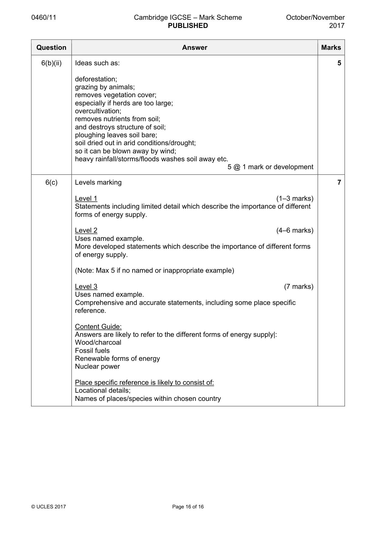
0460/11 Cambridge IGCSE – Mark Scheme PUBLISHED October/November 2017 © UCLES 2017 Page 15 of 16 Question Answer Marks 6(a)(i) Agriculture 1 mark 1 6(a)(ii) Reasoning as appropriate to economic activity chosen e.g. manufacturing: – wildlife poisoned/killed by fumes; – and by pollution of water courses; – forest/vegetation cut down/deforestation – loss of habitat – destruction of food chains etc. 2 @ 1 mark 2 6(a)(iii) Ideas such as: Fossil fuels/coal/oil/natural gas are burnt; Carbon dioxide/greenhouse gases/water vapour/oxides of sulphur & nitrogen build up in the atmosphere; heat is trapped/cannot escape/it acts like a greenhouse etc. 3 @ 1 mark 3 6(a)(iv) Ideas such as: melting of ice caps/glaciers; loss of natural habitat; rising sea/water levels; flooding of low lying islands/countries; loss of food sources for wildlife; loss of species/extinction/animals die (or example); breaking of food chains/threats to predators; diversion of cold ocean currents; warming of sea water can destroy/bleach coral; increasing aridity/drought/desertification; forest fires; vegetation loss/trees die etc. 4 @ 1 mark 4 6(b)(i) Ideas such as: Loss of land/farmland/grazing land; Loss of vegetation/trees; Soil is made bare; Gulleys/cliffs/steep slopes created in soil; Soil washed away etc. 3 @ 1 mark 3
Mark scheme, page 16
0460/11 Cambridge IGCSE – Mark Scheme PUBLISHED October/November 2017 © UCLES 2017 Page 16 of 16 Question Answer Marks 6(b)(ii) Ideas such as: deforestation; grazing by animals; removes vegetation cover; especially if herds are too large; overcultivation; removes nutrients from soil; and destroys structure of soil; ploughing leaves soil bare; soil dried out in arid conditions/drought; so it can be blown away by wind; heavy rainfall/storms/floods washes soil away etc. 5 @ 1 mark or development 5 6(c) Levels marking Level 1 (1–3 marks) Statements including limited detail which describe the importance of different forms of energy supply. Level 2 (4–6 marks) Uses named example. More developed statements which describe the importance of different forms of energy supply. (Note: Max 5 if no named or inappropriate example) Level 3 (7 marks) Uses named example. Comprehensive and accurate statements, including some place specific reference. Content Guide: Answers are likely to refer to the different forms of energy supply|: Wood/charcoal Fossil fuels Renewable forms of energy Nuclear power Place specific reference is likely to consist of: Locational details; Names of places/species within chosen country 7
What you needed in this session
Cambridge’s own grade thresholds for 2017 Oct/Nov, Paper 1 · Variant 1. A higher threshold means an easier paper — the bar moves with how the cohort did.