Cambridge IGCSE Geography 0460 — 2017 Oct/Nov Paper 1 · Variant 2
0460/12/O/N/17 · 75 marks · ≈84 min
The question paper and its mark scheme, free to read here and free to download. This is Cambridge’s own paper, exactly as it was sat.
Question paper28 pages







Mark scheme20 pages
Answers below. Sit the paper first if you are practising.
Paper as text
Question paper, page 1
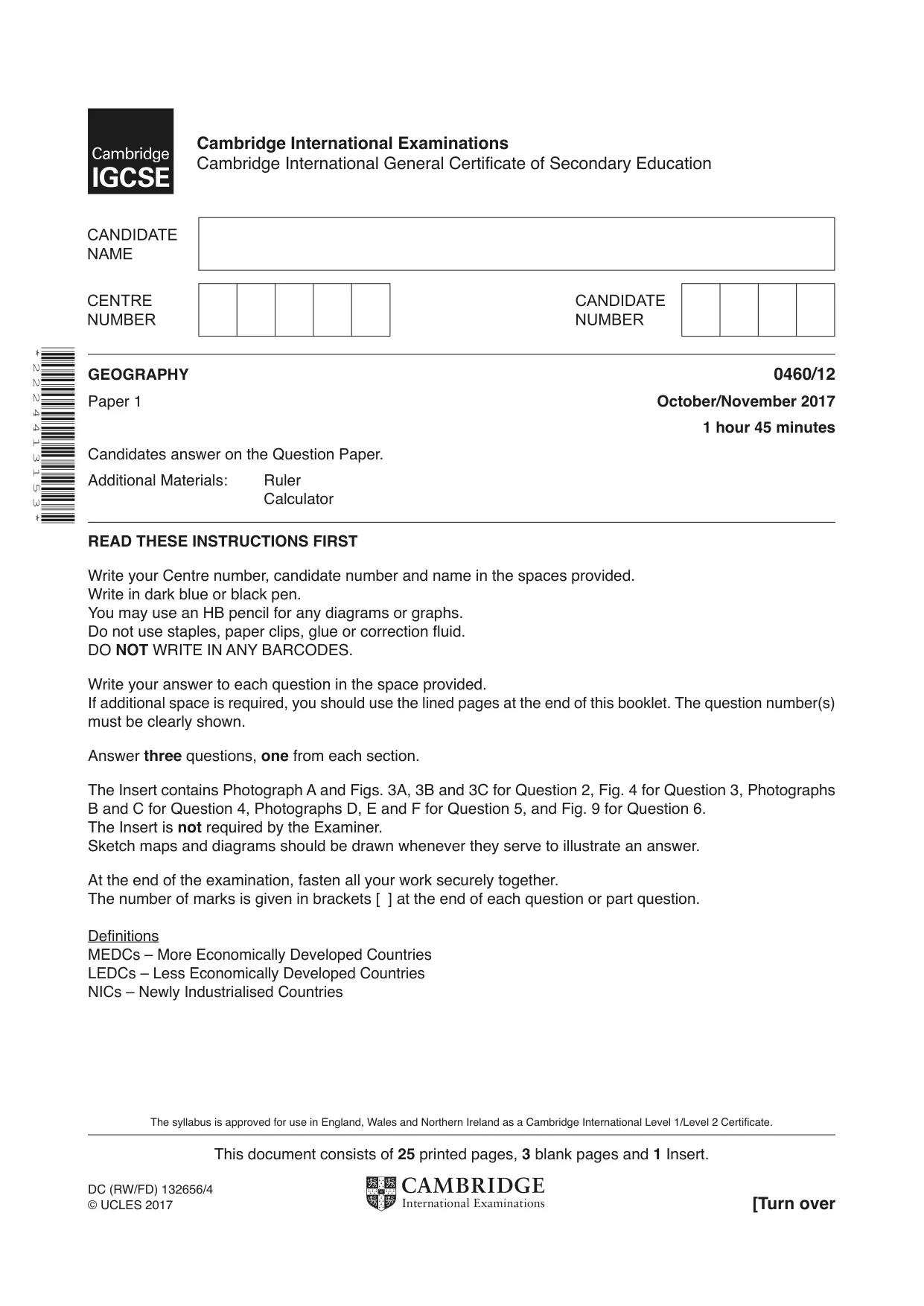
This document consists of 25 printed pages, 3 blank pages and 1 Insert. DC (RW/FD) 132656/4 © UCLES 2017 [Turn over Cambridge International Examinations Cambridge International General Certificate of Secondary Education * 2 2 2 4 4 1 3 1 5 3 * GEOGRAPHY 0460/12 Paper 1 October/November 2017 1 hour 45 minutes Candidates answer on the Question Paper. Additional Materials: Ruler Calculator READ THESE INSTRUCTIONS FIRST Write your Centre number, candidate number and name in the spaces provided. Write in dark blue or black pen. You may use an HB pencil for any diagrams or graphs. Do not use staples, paper clips, glue or correction fluid. DO NOT WRITE IN ANY BARCODES. Write your answer to each question in the space provided. If additional space is required, you should use the lined pages at the end of this booklet. The question number(s) must be clearly shown. Answer three questions, one from each section. The Insert contains Photograph A and Figs. 3A, 3B and 3C for Question 2, Fig. 4 for Question 3, Photographs B and C for Question 4, Photographs D, E and F for Question 5, and Fig. 9 for Question 6. The Insert is not required by the Examiner. Sketch maps and diagrams should be drawn whenever they serve to illustrate an answer. At the end of the examination, fasten all your work securely together. The number of marks is given in brackets [ ] at the end of each question or part question. Definitions MEDCs – More Economically Developed Countries LEDCs – Less Economically Developed Countries NICs – Newly Industrialised Countries The syllabus is approved for use in England, Wales and Northern Ireland as a Cambridge International Level 1/Level 2 Certificate.
Question paper, page 2
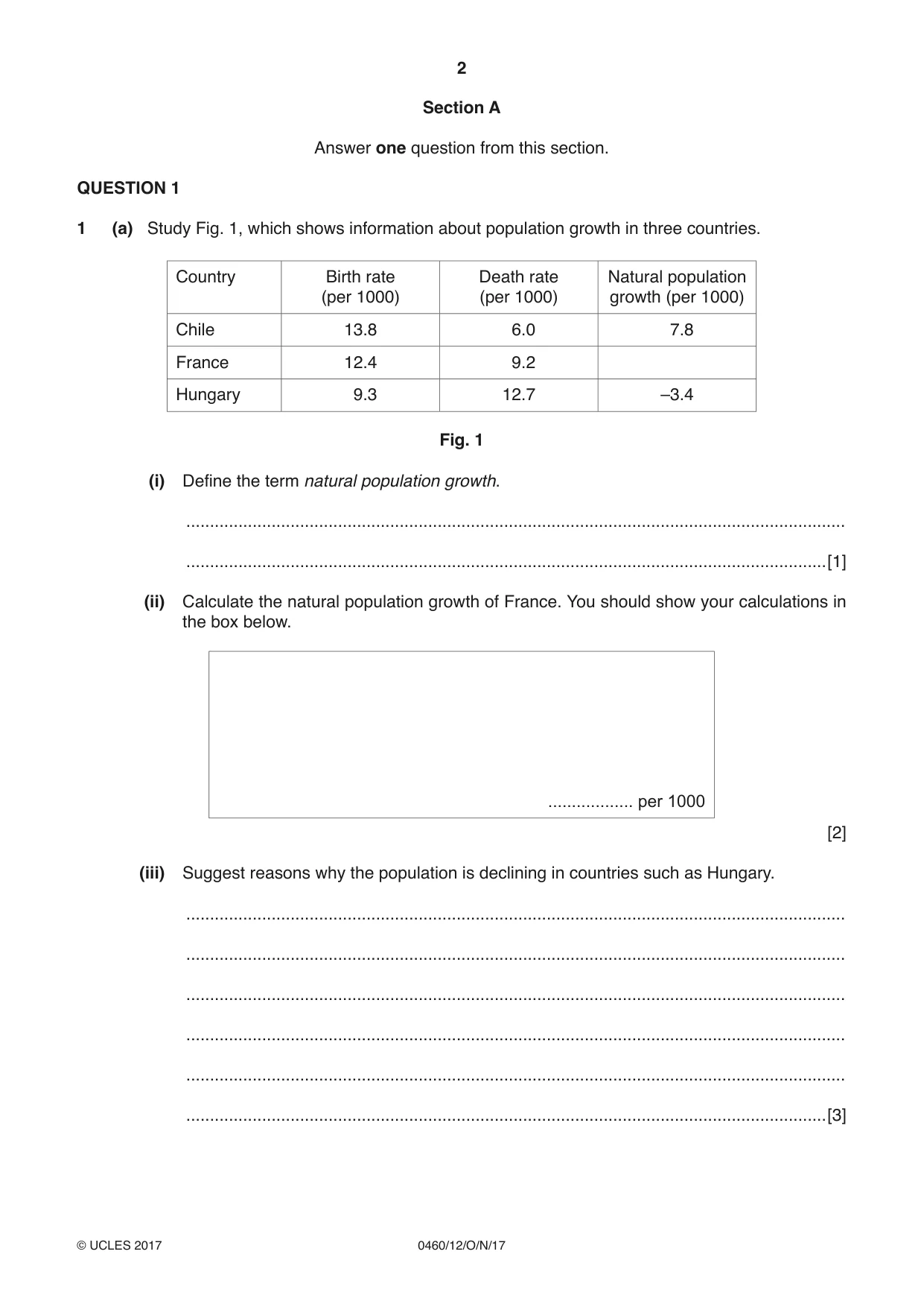
2 0460/12/O/N/17 © UCLES 2017 Section A Answer one question from this section. QUESTION 1 1 (a) Study Fig. 1, which shows information about population growth in three countries. Country Birth rate (per 1000) Death rate (per 1000) Natural population growth (per 1000) Chile 13.8 6.0 7.8 France 12.4 9.2 Hungary 9.3 12.7 –3.4 Fig. 1 (i) Define the term natural population growth. … …[1] (ii) Calculate the natural population growth of France. You should show your calculations in the box below. … per 1000 [2] (iii) Suggest reasons why the population is declining in countries such as Hungary. … … … … … …[3]
Question paper, page 3
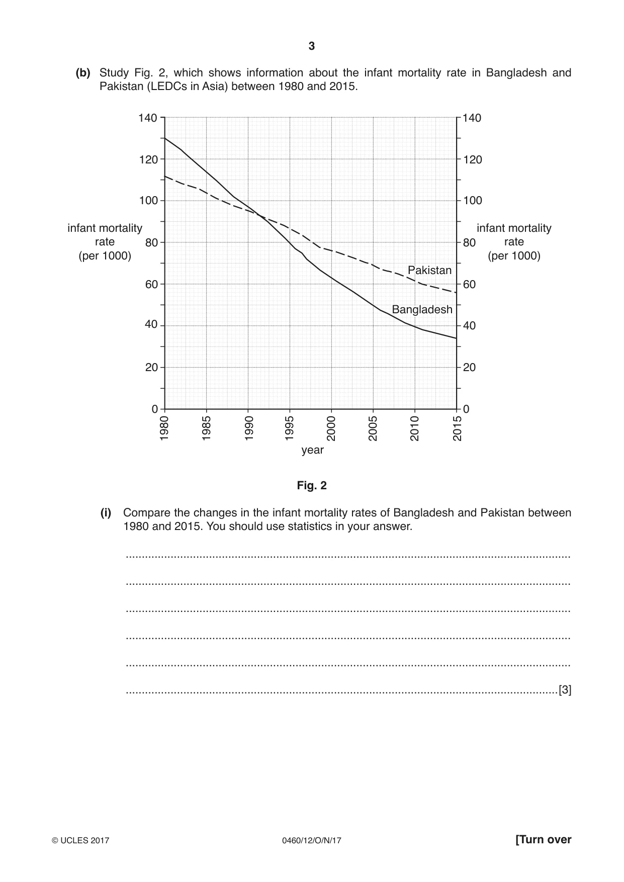
3 0460/12/O/N/17 © UCLES 2017 [Turn over (b) Study Fig. 2, which shows information about the infant mortality rate in Bangladesh and Pakistan (LEDCs in Asia) between 1980 and 2015. 120 100 80 60 40 20 0 140 120 100 80 60 40 20 0 140 1980 1990 1985 1995 2000 2005 2010 2015 infant mortality rate (per 1000) infant mortality rate (per 1000) year Pakistan Bangladesh Pakistan Bangladesh Fig. 2 (i) Compare the changes in the infant mortality rates of Bangladesh and Pakistan between 1980 and 2015. You should use statistics in your answer. … … … … … …[3]
Question paper, page 4
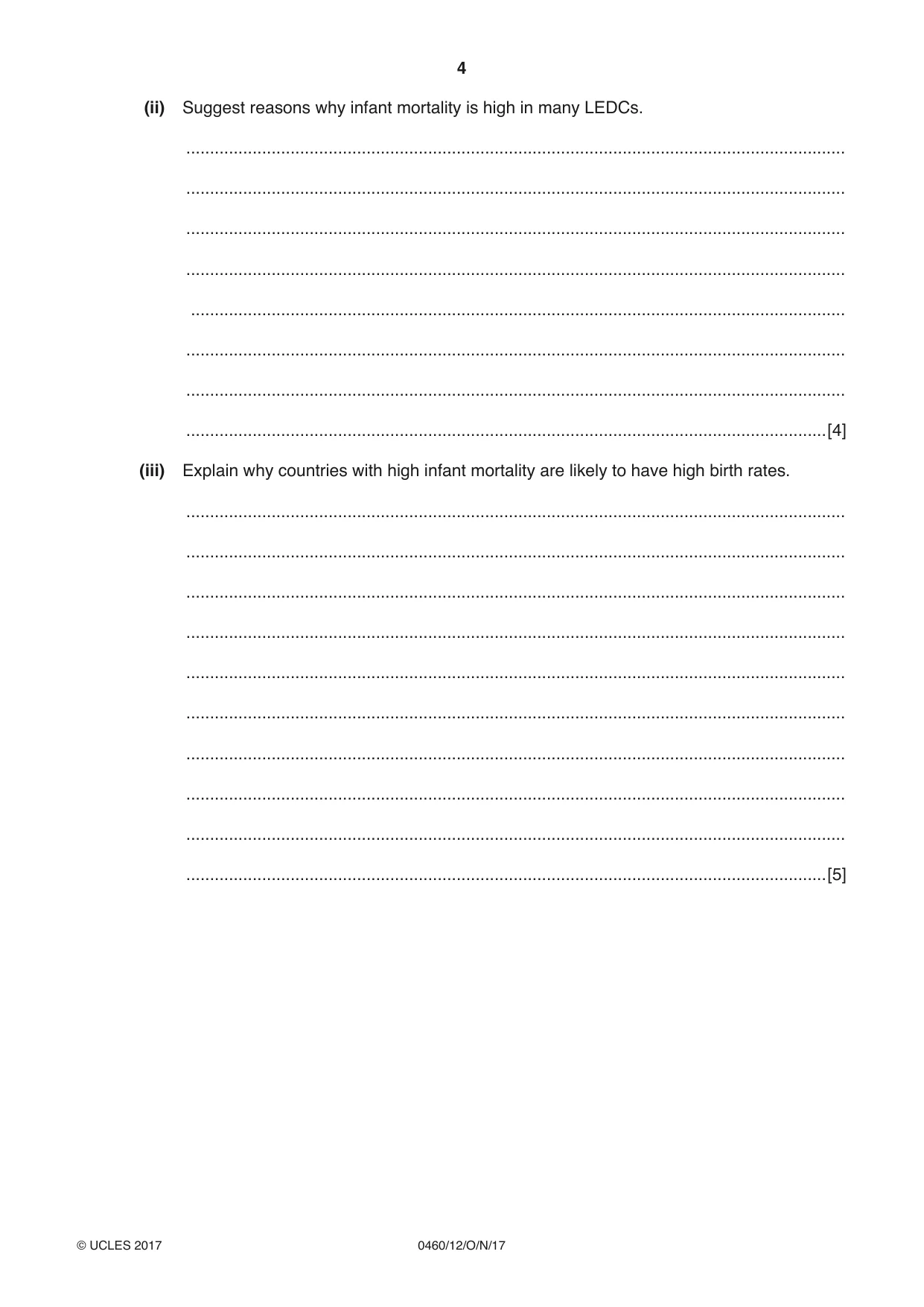
4 0460/12/O/N/17 © UCLES 2017 (ii) Suggest reasons why infant mortality is high in many LEDCs. … … … … … … … …[4] (iii) Explain why countries with high infant mortality are likely to have high birth rates. … … … … … … … … … …[5]
Question paper, page 5
5 0460/12/O/N/17 © UCLES 2017 [Turn over (c) For a named country you have studied, describe a population policy or policies which has been used to influence its growth rate. Name of country … … … … … … … … … … … … … … … … … … … … … … … … …[7] [Total: 25 marks] END OF QUESTION 1
Question paper, page 6
6 0460/12/O/N/17 © UCLES 2017 QUESTION 2 2 (a) Study Photograph A (Insert), which shows a rural settlement in Lesotho (an LEDC in Africa). (i) What is meant by a rural settlement? … …[1] (ii) Using evidence from Photograph A only, describe two characteristics of the houses in the settlement shown. … … … …[2] (iii) Explain how rural settlements, such as the one shown in Photograph A, fit into the hierarchy of settlement in a country. … … … … … …[3] (iv) Explain why many people have migrated away from rural settlements, such as the one shown in Photograph A. … … … … … … … …[4]
Question paper, page 7
7 0460/12/O/N/17 © UCLES 2017 [Turn over (b) Study Figs. 3A, 3B and 3C (Insert), which show maps of three rural settlements in the Czech Republic (an MEDC in Europe). (i) Identify the settlement patterns shown by each of the three maps. Fig. 3A … Fig. 3B … Fig. 3C … [3] (ii) Suggest reasons why different settlement patterns have developed in the areas shown in Figs. 3A, 3B and 3C. … … … … … … … … … …[5]
Question paper, page 8
8 0460/12/O/N/17 © UCLES 2017 (c) Give reasons for the growth of a named urban settlement (town or city). Name of town or city … … … … … … … … … … … … … … … … … … … … … … … … …[7] [Total: 25 marks] END OF QUESTION 2
Question paper, page 9
9 0460/12/O/N/17 © UCLES 2017 [Turn over Section B Answer one question from this section. QUESTION 3 3 (a) Study Fig. 4 (Insert), a map showing the location of recorded earthquakes which have occurred in New Zealand. (i) What is meant by the focus of an earthquake? … …[1] (ii) Identify the depth of the focus and the strength (on the Richter scale) of the earthquake which occurred at 40 °S 178 °E. Depth of focus … km Strength … [2] (iii) Using Fig. 4 only, compare the similarities and differences of the earthquakes which have occurred on North Island and South Island of New Zealand. … … … … … …[3] (iv) Using Fig. 4, explain why New Zealand experiences earthquakes. … … … … … … … …[4]
Question paper, page 10
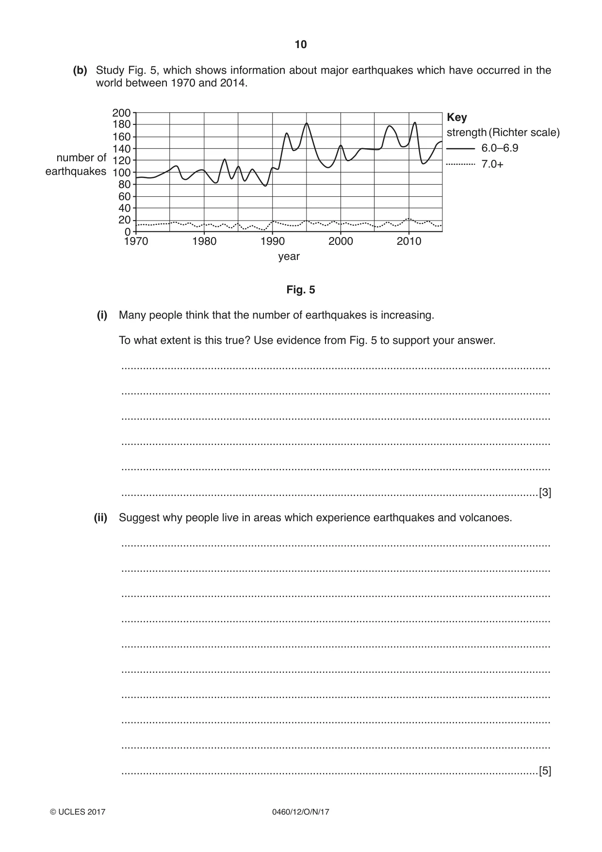
10 0460/12/O/N/17 © UCLES 2017 (b) Study Fig. 5, which shows information about major earthquakes which have occurred in the world between 1970 and 2014. 0 1970 strength (Richter scale) Key 6.0–6.9 7.0+ 1980 1990 year 2000 2010 20 40 60 80 100 120 number of earthquakes 140 160 180 200 Fig. 5 (i) Many people think that the number of earthquakes is increasing. To what extent is this true? Use evidence from Fig. 5 to support your answer. … … … … … …[3] (ii) Suggest why people live in areas which experience earthquakes and volcanoes. … … … … … … … … … …[5]
Question paper, page 11
11 0460/12/O/N/17 © UCLES 2017 [Turn over (c) Describe the hazards created by a named volcanic eruption you have studied. Name of volcano … … … … … … … … … … … … … … … … … … … … … … … … …[7] [Total: 25 marks] END OF QUESTION 3
Question paper, page 12
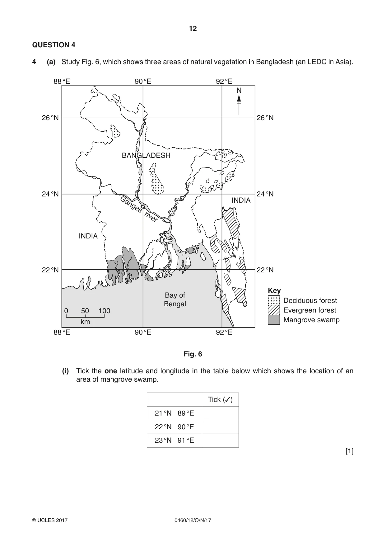
12 0460/12/O/N/17 © UCLES 2017 QUESTION 4 4 (a) Study Fig. 6, which shows three areas of natural vegetation in Bangladesh (an LEDC in Asia). Bay of Bengal INDIA Ganges river INDIA 88 °E 90 °E 92 °E 88 °E 90 °E 92 °E 22 °N 24 °N 26 °N 22 °N 24 °N 26 °N 0 50 100 km Key N Mangrove swamp Evergreen forest Deciduous forest BANGLADESH BANGLADESH Fig. 6 (i) Tick the one latitude and longitude in the table below which shows the location of an area of mangrove swamp. Tick (✓) 21 °N 89 °E 22 °N 90 °E 23 °N 91 °E [1]
Question paper, page 13
13 0460/12/O/N/17 © UCLES 2017 [Turn over (ii) Using Fig. 6 only, describe the distribution of the areas of mangrove swamp. … … … …[2] (iii) Describe the main features of a mangrove swamp. … … … … … …[3] (iv) Coral reefs are located along many coastlines in tropical areas. Describe four conditions which are needed for the development of a coral reef. 1 … … 2 … … 3 … … 4 … …[4]
Question paper, page 14
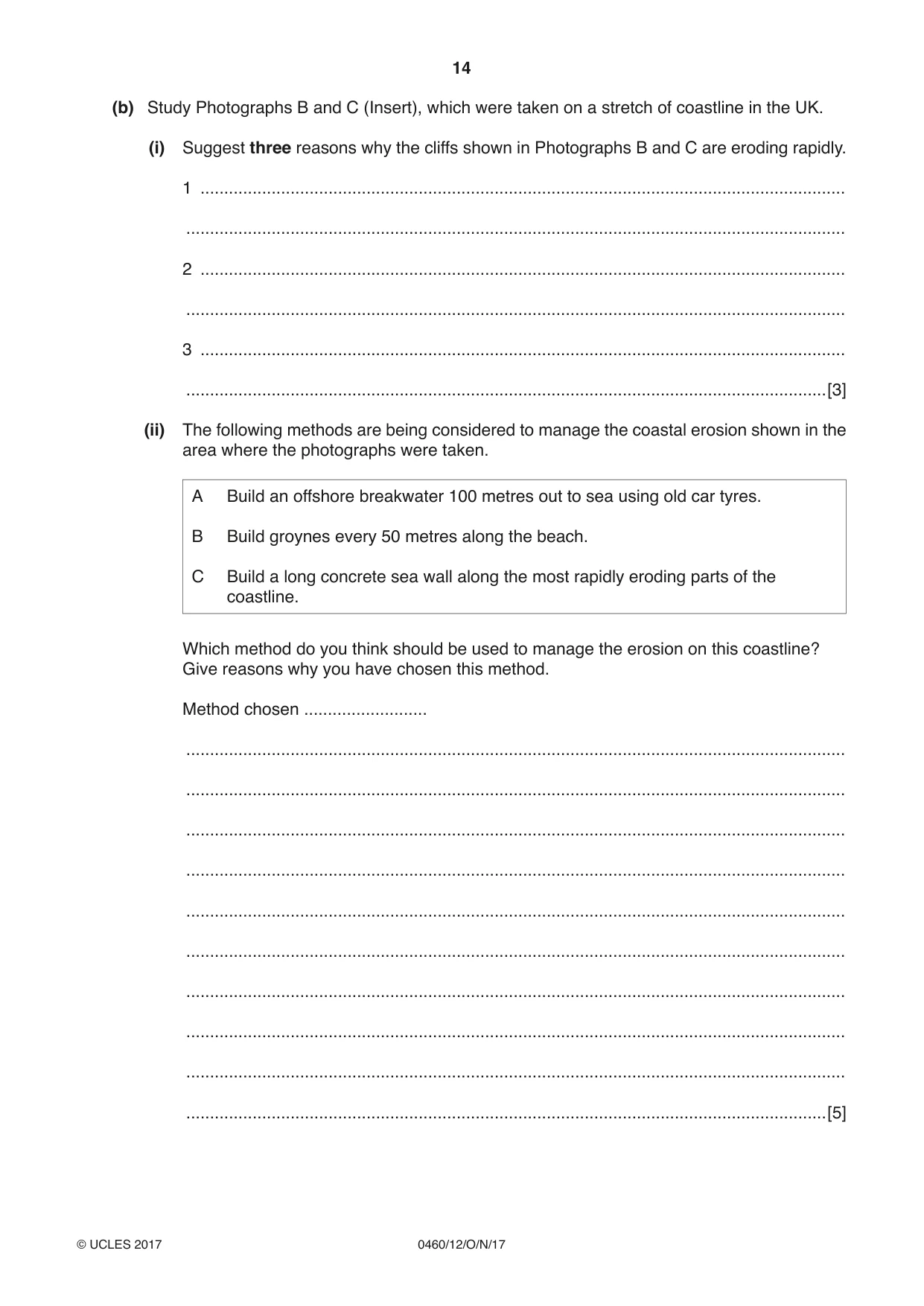
14 0460/12/O/N/17 © UCLES 2017 (b) Study Photographs B and C (Insert), which were taken on a stretch of coastline in the UK. (i) Suggest three reasons why the cliffs shown in Photographs B and C are eroding rapidly. 1 … … 2 … … 3 … …[3] (ii) The following methods are being considered to manage the coastal erosion shown in the area where the photographs were taken. A Build an offshore breakwater 100 metres out to sea using old car tyres. B Build groynes every 50 metres along the beach. C Build a long concrete sea wall along the most rapidly eroding parts of the coastline. Which method do you think should be used to manage the erosion on this coastline? Give reasons why you have chosen this method. Method chosen … … … … … … … … … … …[5]
Question paper, page 15
15 0460/12/O/N/17 © UCLES 2017 [Turn over (c) Explain why people live along a named area of coastline you have studied. Name of area of coastline … … … … … … … … … … … … … … … … … … … … … … … … …[7] [Total: 25 marks] END OF QUESTION 4
Question paper, page 16
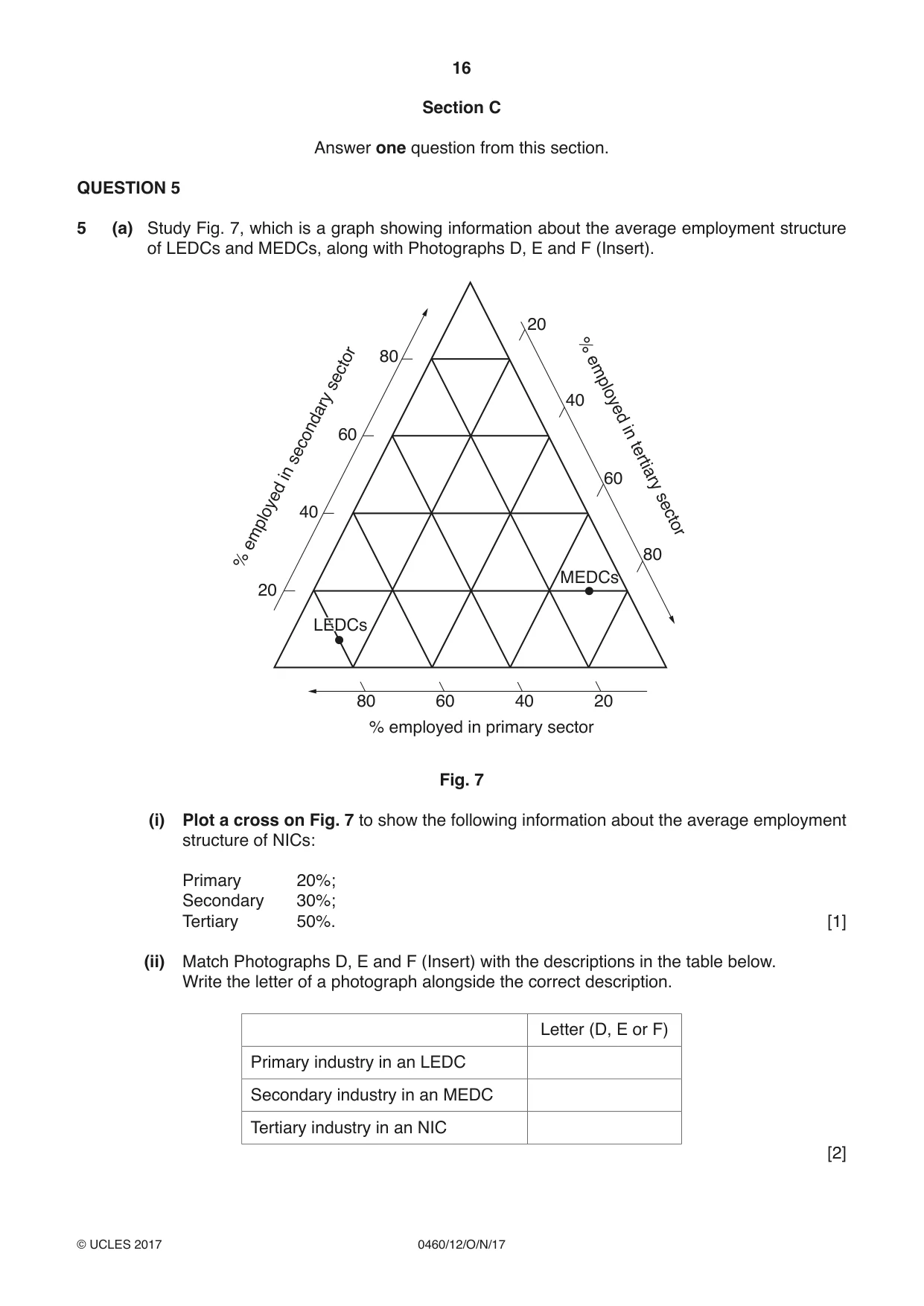
16 0460/12/O/N/17 © UCLES 2017 Section C Answer one question from this section. QUESTION 5 5 (a) Study Fig. 7, which is a graph showing information about the average employment structure of LEDCs and MEDCs, along with Photographs D, E and F (Insert). 80 80 60 60 % employed in primary sector % employed in secondary sector % employed in tertiary sector 40 MEDCs LEDC LEDCs 40 20 20 80 60 40 20 Fig. 7 (i) Plot a cross on Fig. 7 to show the following information about the average employment structure of NICs: Primary 20%; Secondary 30%; Tertiary 50%. [1] (ii) Match Photographs D, E and F (Insert) with the descriptions in the table below. Write the letter of a photograph alongside the correct description. Letter (D, E or F) Primary industry in an LEDC Secondary industry in an MEDC Tertiary industry in an NIC [2]
Question paper, page 17
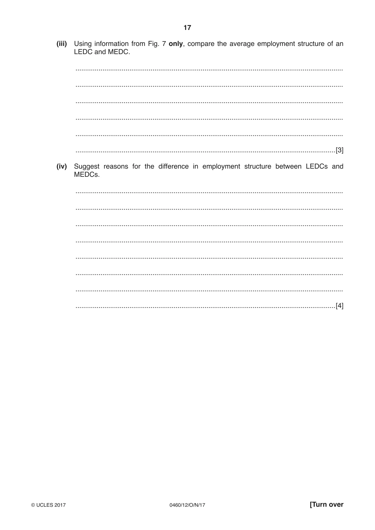
17 0460/12/O/N/17 © UCLES 2017 [Turn over (iii) Using information from Fig. 7 only, compare the average employment structure of an LEDC and MEDC. … … … … … …[3] (iv) Suggest reasons for the difference in employment structure between LEDCs and MEDCs. … … … … … … … …[4]
Question paper, page 18
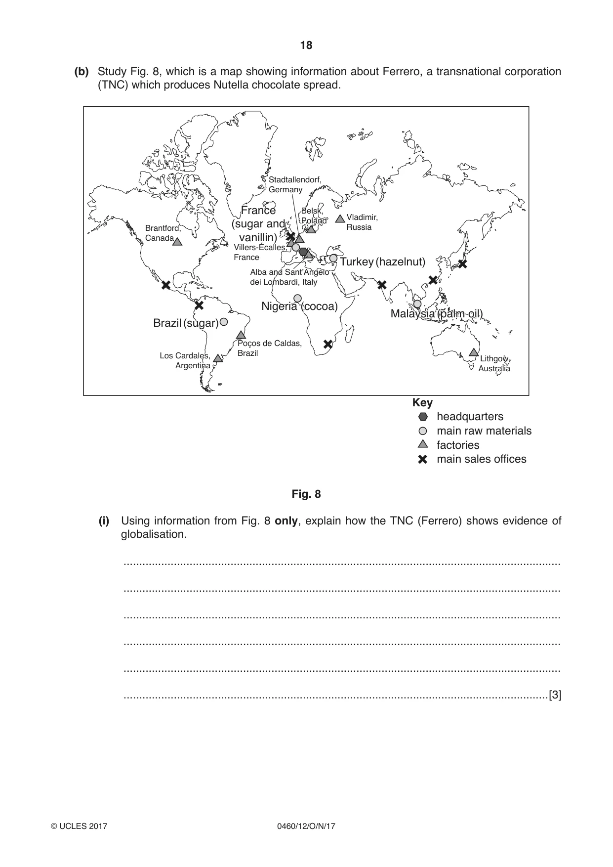
18 0460/12/O/N/17 © UCLES 2017 (b) Study Fig. 8, which is a map showing information about Ferrero, a transnational corporation (TNC) which produces Nutella chocolate spread. Key headquarters main raw materials factories main sales offices Brantford, Canada France (sugar and vanilla) France (sugar and vanillin) Turkey (hazelnut) Malaysia (palm oil) Malaysia (palm oil) Villers-Écalles, France Stadtallendorf, Germany Vladimir, Russia Belsk, Poland Belsk, Poland Alba and Sant’Angelo dei Lombardi, Italy Alba and Sant’Angelo dei Lombardi, Italy Brazil (sugar) Brazil (sugar) Los Cardales, Argentina Los Cardales, Argentina Lithgow, Australia Lithgow, Australia Poҫos de Caldas, Brazil Nigeria (cocoa) Nigeria (cocoa) Fig. 8 (i) Using information from Fig. 8 only, explain how the TNC (Ferrero) shows evidence of globalisation. … … … … … …[3]
Question paper, page 19
19 0460/12/O/N/17 © UCLES 2017 [Turn over (ii) Explain why globalisation has occurred. … … … … … … … … … …[5]
Question paper, page 20
20 0460/12/O/N/17 © UCLES 2017 (c) For a named example you have studied, describe the impacts of a transnational corporation (TNC) on an LEDC. Name of transnational corporation (TNC) … Name of LEDC … … … … … … … … … … … … … … … … … … … … … … … …[7] [Total: 25 marks] END OF QUESTION 5
Question paper, page 21
21 0460/12/O/N/17 © UCLES 2017 [Turn over QUESTION 6 6 (a) Study Fig. 9 (Insert), which is a map showing information about industry in Panama (an LEDC in Central America). (i) What is meant by manufacturing? … …[1] (ii) Identify the following from Fig. 9: - A food processing industry in Colón; … - A crop grown around Puerto Armuelles. … [2] (iii) What evidence on Fig. 9 suggests that raw materials influence the location of manufacturing industry in Panama? … … … … … …[3] (iv) Suggest other factors which may have influenced the location of manufacturing industry in Panama. … … … … … … … …[4]
Question paper, page 22
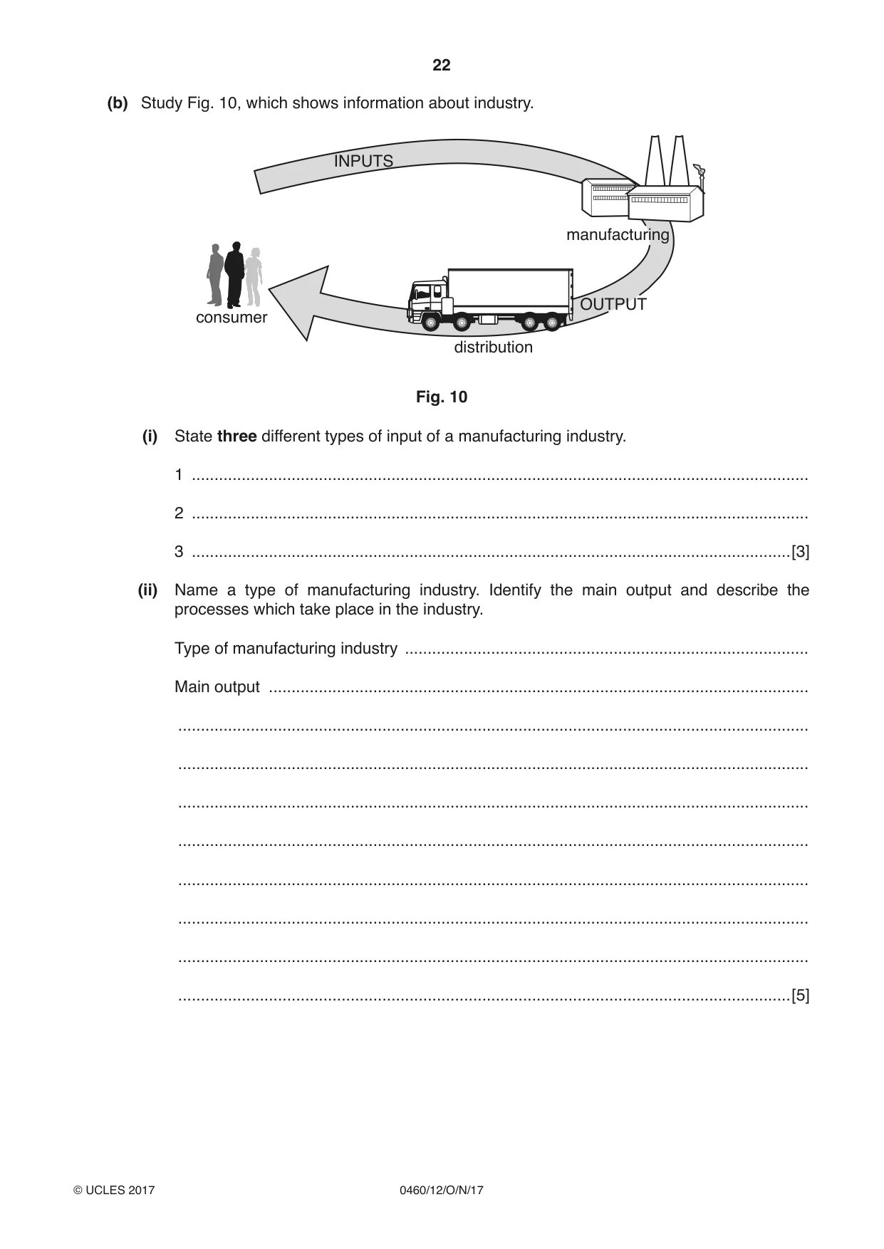
22 0460/12/O/N/17 © UCLES 2017 (b) Study Fig. 10, which shows information about industry. INPUTS consumer distribution manufacturing OUTPUT Fig. 10 (i) State three different types of input of a manufacturing industry. 1 … 2 … 3 …[3] (ii) Name a type of manufacturing industry. Identify the main output and describe the processes which take place in the industry. Type of manufacturing industry … Main output … … … … … … … … …[5]
Question paper, page 23
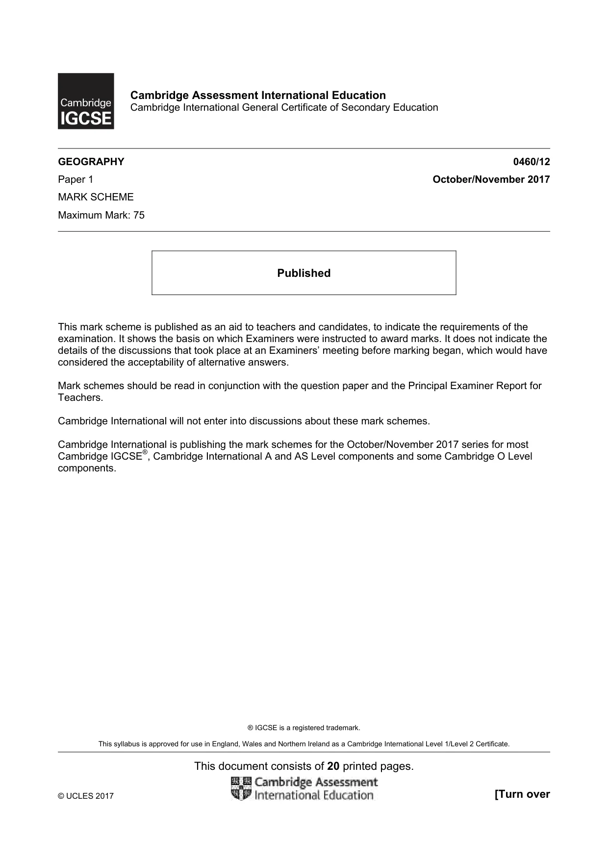
23 0460/12/O/N/17 © UCLES 2017 (c) For a farm or agricultural system in a named area you have studied, explain how the land use is influenced by natural factors. Name of area … … … … … … … … … … … … … … … … … … … … … … … …[7] [Total: 25 marks] END OF QUESTION 6
Question paper, page 24
24 0460/12/O/N/17 © UCLES 2017 Additional Pages If you use the following lined pages to complete the answer(s) to any question(s), the question number(s) must be clearly shown. … … … … … … … … … … … … … … … … … … … … … … … … … …
Question paper, page 25
25 0460/12/O/N/17 © UCLES 2017 … … … … … … … … … … … … … … … … … … … … … … … … … … … …
Question paper, page 26
26 0460/12/O/N/17 © UCLES 2017 BLANK PAGE
Question paper, page 27
27 0460/12/O/N/17 © UCLES 2017 BLANK PAGE
Question paper, page 28
28 0460/12/O/N/17 © UCLES 2017 Permission to reproduce items where third-party owned material protected by copyright is included has been sought and cleared where possible. Every reasonable effort has been made by the publisher (UCLES) to trace copyright holders, but if any items requiring clearance have unwittingly been included, the publisher will be pleased to make amends at the earliest possible opportunity. To avoid the issue of disclosure of answer-related information to candidates, all copyright acknowledgements are reproduced online in the Cambridge International Examinations Copyright Acknowledgements Booklet. This is produced for each series of examinations and is freely available to download at www.cie.org.uk after the live examination series. Cambridge International Examinations is part of the Cambridge Assessment Group. Cambridge Assessment is the brand name of University of Cambridge Local Examinations Syndicate (UCLES), which is itself a department of the University of Cambridge. BLANK PAGE
Mark scheme, page 1
® IGCSE is a registered trademark. This syllabus is approved for use in England, Wales and Northern Ireland as a Cambridge International Level 1/Level 2 Certificate. This document consists of 20 printed pages. © UCLES 2017 [Turn over Cambridge Assessment International Education Cambridge International General Certificate of Secondary Education GEOGRAPHY 0460/12 Paper 1 October/November 2017 MARK SCHEME Maximum Mark: 75 Published This mark scheme is published as an aid to teachers and candidates, to indicate the requirements of the examination. It shows the basis on which Examiners were instructed to award marks. It does not indicate the details of the discussions that took place at an Examiners’ meeting before marking began, which would have considered the acceptability of alternative answers. Mark schemes should be read in conjunction with the question paper and the Principal Examiner Report for Teachers. Cambridge International will not enter into discussions about these mark schemes. Cambridge International is publishing the mark schemes for the October/November 2017 series for most Cambridge IGCSE®, Cambridge International A and AS Level components and some Cambridge O Level components.
Mark scheme, page 2
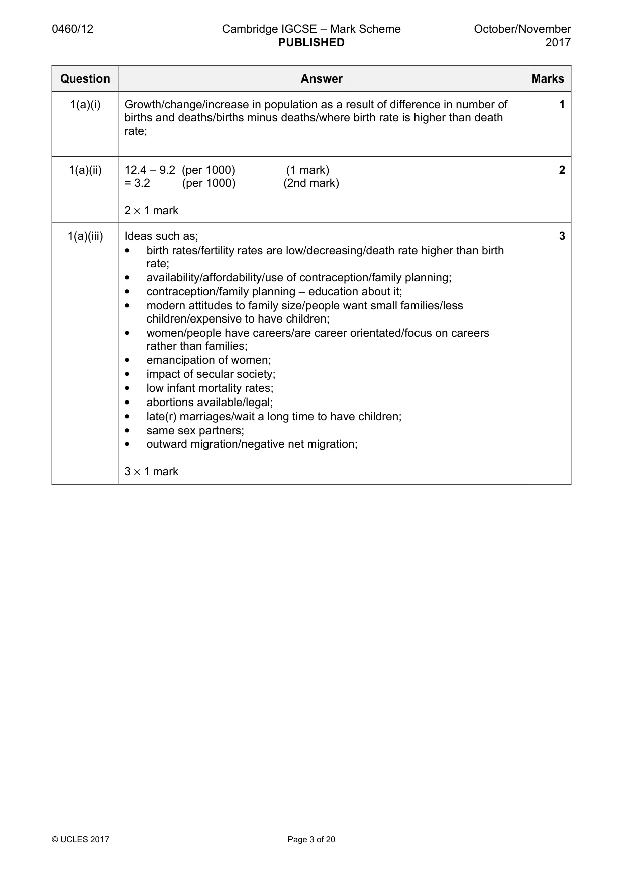
0460/12 Cambridge IGCSE – Mark Scheme PUBLISHED October/November 2017 © UCLES 2017 Page 2 of 20 Levels of response marking is used for section (c) of each question. Thus it is the quality of the response that determines which level an answer is achieved rather than the quantity of statements contained within it. However, once assigned to a level the mark achieved within that level is determined by the number of points made. Levels 1 and 2 are distinguished by whether statements are simple (level 1) or developed/elaborated (level 2). A candidate can immediately enter L2 by making developed points without making any L1 statements. In order to achieve L3 a candidate must have already reached the top end of L2 – in addition his/her answer should have a clear example and if the answer is place specific as well (7 marks). Highlight place specific detail. Where statements are assigned levels by the examiner this should be indicated by the use of L1 and L2 next to the statements. Ticks should not be used on answers that are marked using levels of response marking. L1 annotation should be removed once a L2 is awarded for an answer. L3 annotation is not used. There is no need for a summary level at the end of a response. Summary: Level 1 (1 to 3 marks): 1 simple statement (1 mark) 2 simple statements (2 marks) 3 simple statements (3 marks) Level 2 (4 to 6 marks): 1 developed statement (4 marks) 2 developed statements (5 marks) 3 or more developed statements with e.g. (6 marks) Level 3 (7 marks) 3 or more developed statements + named example with at least one piece of place specific detail.
Mark scheme, page 3
0460/12 Cambridge IGCSE – Mark Scheme PUBLISHED October/November 2017 © UCLES 2017 Page 3 of 20 Question Answer Marks 1(a)(i) Growth/change/increase in population as a result of difference in number of births and deaths/births minus deaths/where birth rate is higher than death rate; 1 1(a)(ii) 12.4 – 9.2 (per 1000) (1 mark) = 3.2 (per 1000) (2nd mark) 2 × 1 mark 2 1(a)(iii) Ideas such as; • birth rates/fertility rates are low/decreasing/death rate higher than birth rate; • availability/affordability/use of contraception/family planning; • contraception/family planning – education about it; • modern attitudes to family size/people want small families/less children/expensive to have children; • women/people have careers/are career orientated/focus on careers rather than families; • emancipation of women; • impact of secular society; • low infant mortality rates; • abortions available/legal; • late(r) marriages/wait a long time to have children; • same sex partners; • outward migration/negative net migration; 3 × 1 mark 3
Mark scheme, page 4
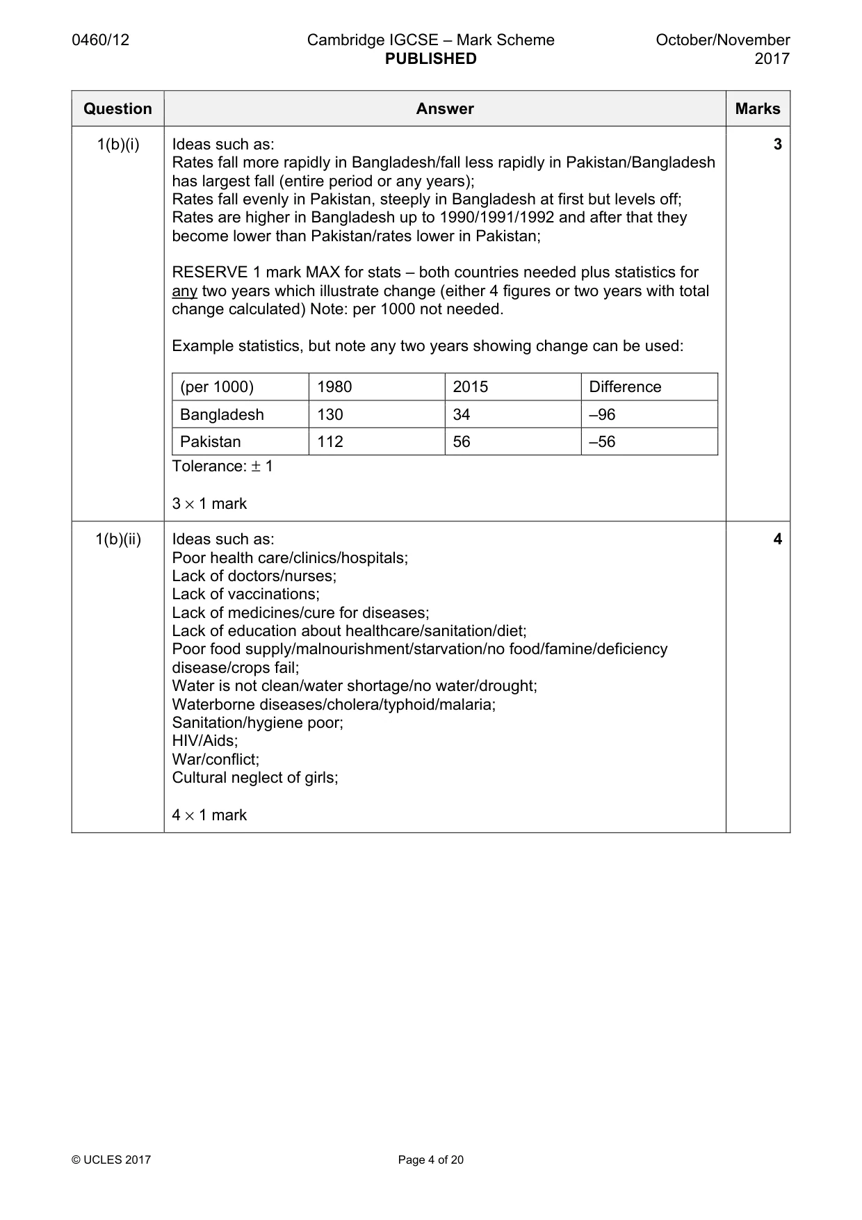
0460/12 Cambridge IGCSE – Mark Scheme PUBLISHED October/November 2017 © UCLES 2017 Page 4 of 20 Question Answer Marks 1(b)(i) Ideas such as: Rates fall more rapidly in Bangladesh/fall less rapidly in Pakistan/Bangladesh has largest fall (entire period or any years); Rates fall evenly in Pakistan, steeply in Bangladesh at first but levels off; Rates are higher in Bangladesh up to 1990/1991/1992 and after that they become lower than Pakistan/rates lower in Pakistan; RESERVE 1 mark MAX for stats – both countries needed plus statistics for any two years which illustrate change (either 4 figures or two years with total change calculated) Note: per 1000 not needed. Example statistics, but note any two years showing change can be used: (per 1000) 1980 2015 Difference Bangladesh 130 34 –96 Pakistan 112 56 –56 Tolerance: ± 1 3 × 1 mark 3 1(b)(ii) Ideas such as: Poor health care/clinics/hospitals; Lack of doctors/nurses; Lack of vaccinations; Lack of medicines/cure for diseases; Lack of education about healthcare/sanitation/diet; Poor food supply/malnourishment/starvation/no food/famine/deficiency disease/crops fail; Water is not clean/water shortage/no water/drought; Waterborne diseases/cholera/typhoid/malaria; Sanitation/hygiene poor; HIV/Aids; War/conflict; Cultural neglect of girls; 4 × 1 mark 4
Mark scheme, page 5
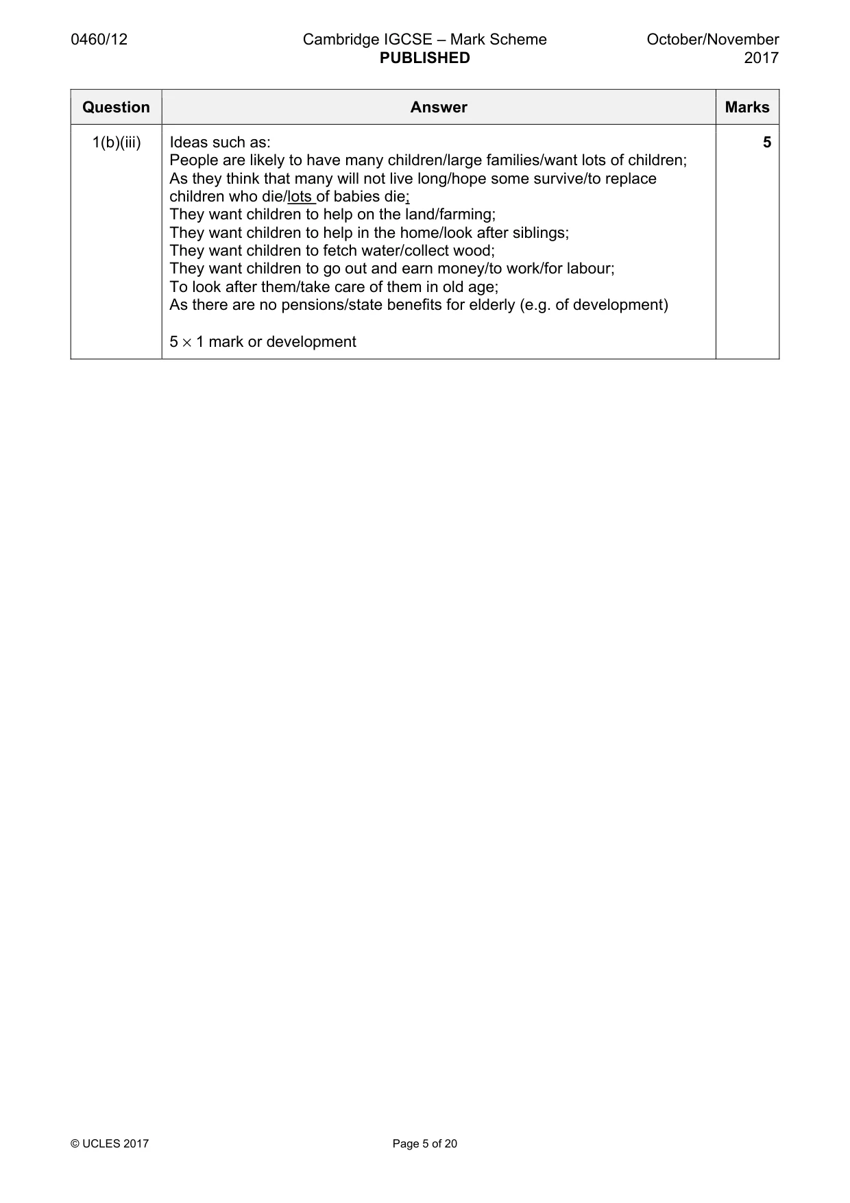
0460/12 Cambridge IGCSE – Mark Scheme PUBLISHED October/November 2017 © UCLES 2017 Page 5 of 20 Question Answer Marks 1(b)(iii) Ideas such as: People are likely to have many children/large families/want lots of children; As they think that many will not live long/hope some survive/to replace children who die/lots of babies die; They want children to help on the land/farming; They want children to help in the home/look after siblings; They want children to fetch water/collect wood; They want children to go out and earn money/to work/for labour; To look after them/take care of them in old age; As there are no pensions/state benefits for elderly (e.g. of development) 5 × 1 mark or development 5
Mark scheme, page 6
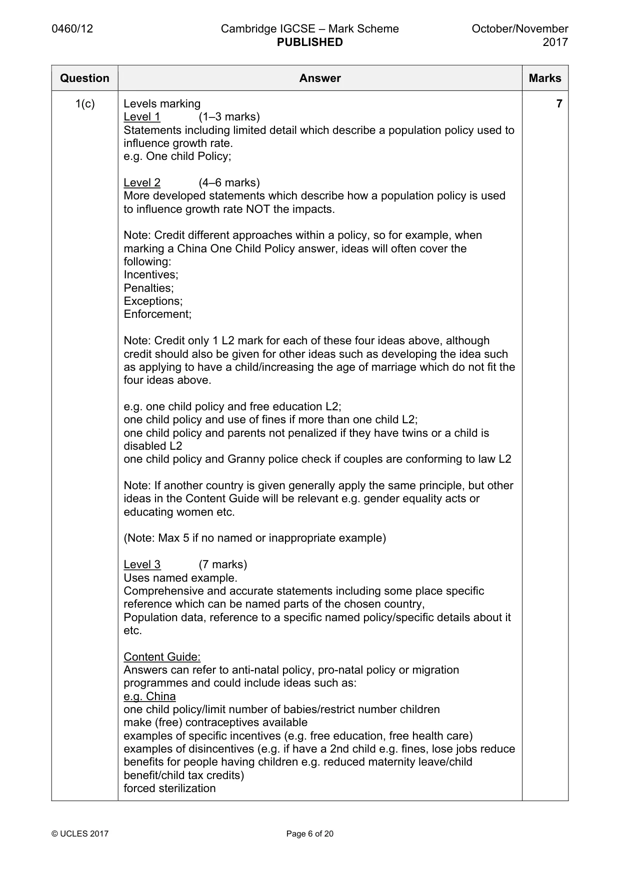
0460/12 Cambridge IGCSE – Mark Scheme PUBLISHED October/November 2017 © UCLES 2017 Page 6 of 20 Question Answer Marks 1(c) Levels marking Level 1 (1–3 marks) Statements including limited detail which describe a population policy used to influence growth rate. e.g. One child Policy; Level 2 (4–6 marks) More developed statements which describe how a population policy is used to influence growth rate NOT the impacts. Note: Credit different approaches within a policy, so for example, when marking a China One Child Policy answer, ideas will often cover the following: Incentives; Penalties; Exceptions; Enforcement; Note: Credit only 1 L2 mark for each of these four ideas above, although credit should also be given for other ideas such as developing the idea such as applying to have a child/increasing the age of marriage which do not fit the four ideas above. e.g. one child policy and free education L2; one child policy and use of fines if more than one child L2; one child policy and parents not penalized if they have twins or a child is disabled L2 one child policy and Granny police check if couples are conforming to law L2 Note: If another country is given generally apply the same principle, but other ideas in the Content Guide will be relevant e.g. gender equality acts or educating women etc. (Note: Max 5 if no named or inappropriate example) Level 3 (7 marks) Uses named example. Comprehensive and accurate statements including some place specific reference which can be named parts of the chosen country, Population data, reference to a specific named policy/specific details about it etc. Content Guide: Answers can refer to anti-natal policy, pro-natal policy or migration programmes and could include ideas such as: e.g. China one child policy/limit number of babies/restrict number children make (free) contraceptives available examples of specific incentives (e.g. free education, free health care) examples of disincentives (e.g. if have a 2nd child e.g. fines, lose jobs reduce benefits for people having children e.g. reduced maternity leave/child benefit/child tax credits) forced sterilization 7
Mark scheme, page 7
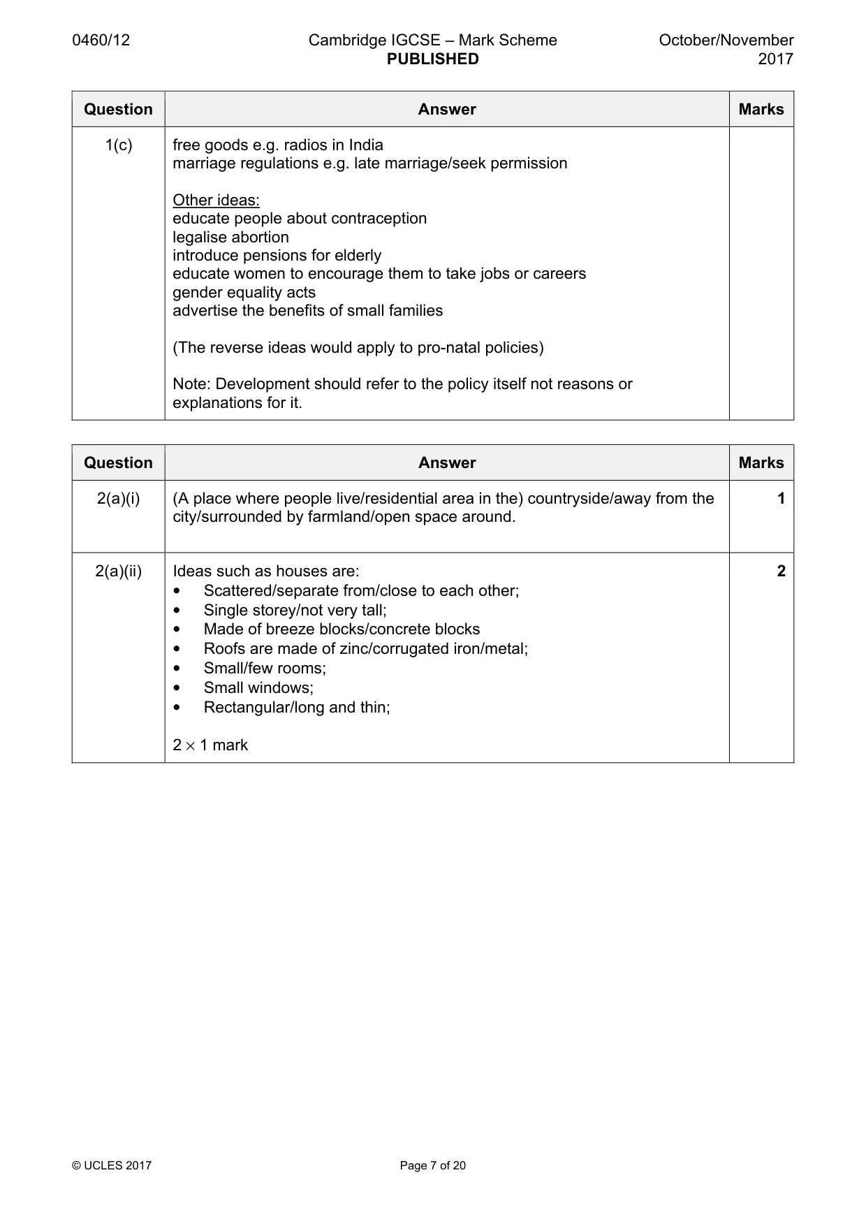
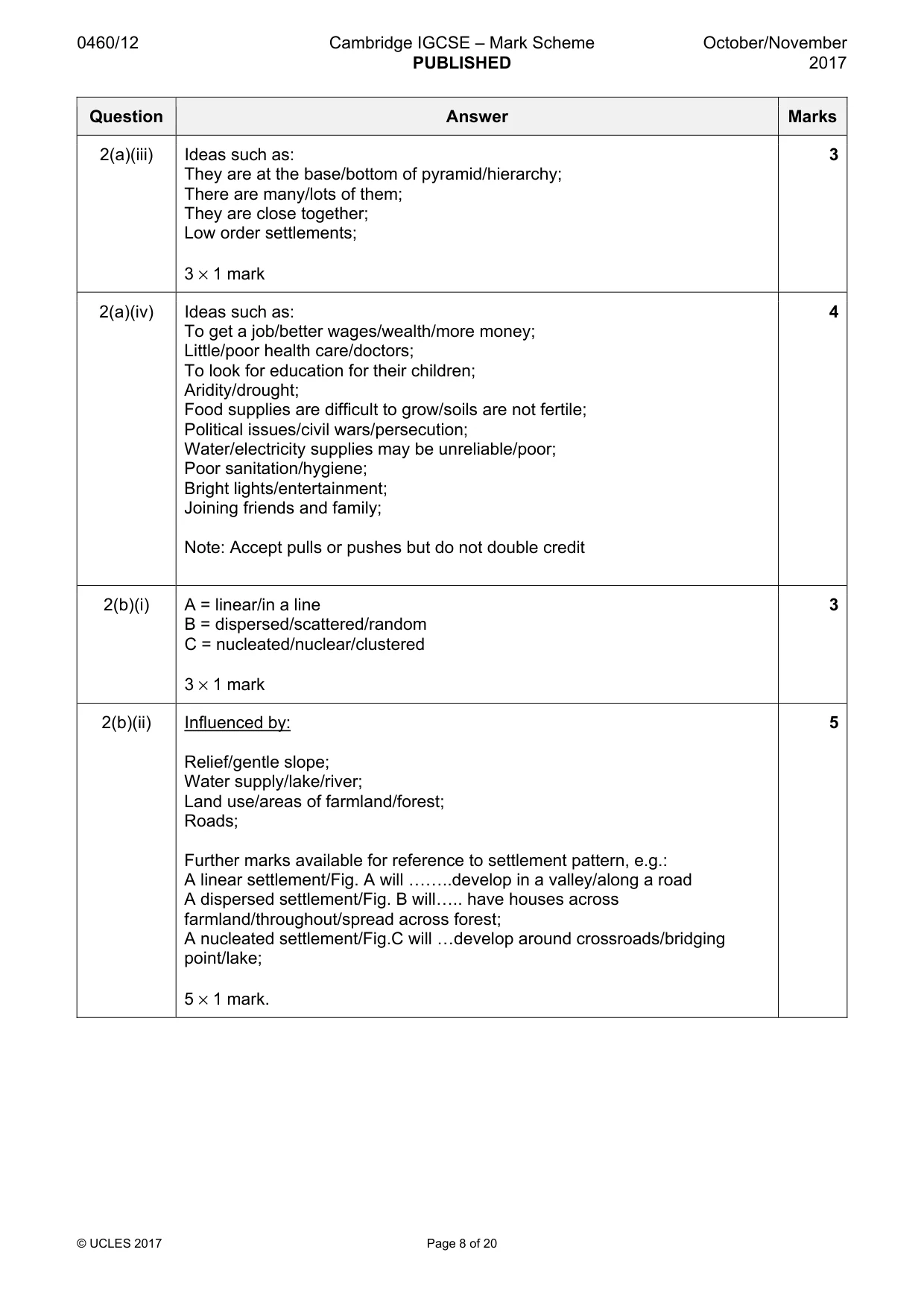
0460/12 Cambridge IGCSE – Mark Scheme PUBLISHED October/November 2017 © UCLES 2017 Page 7 of 20 Question Answer Marks 1(c) free goods e.g. radios in India marriage regulations e.g. late marriage/seek permission Other ideas: educate people about contraception legalise abortion introduce pensions for elderly educate women to encourage them to take jobs or careers gender equality acts advertise the benefits of small families (The reverse ideas would apply to pro-natal policies) Note: Development should refer to the policy itself not reasons or explanations for it. Question Answer Marks 2(a)(i) (A place where people live/residential area in the) countryside/away from the city/surrounded by farmland/open space around. 1 2(a)(ii) Ideas such as houses are: • Scattered/separate from/close to each other; • Single storey/not very tall; • Made of breeze blocks/concrete blocks • Roofs are made of zinc/corrugated iron/metal; • Small/few rooms; • Small windows; • Rectangular/long and thin; 2 × 1 mark 2
Mark scheme, page 8
0460/12 Cambridge IGCSE – Mark Scheme PUBLISHED October/November 2017 © UCLES 2017 Page 8 of 20 Question Answer Marks 2(a)(iii) Ideas such as: They are at the base/bottom of pyramid/hierarchy; There are many/lots of them; They are close together; Low order settlements; 3 × 1 mark 3 2(a)(iv) Ideas such as: To get a job/better wages/wealth/more money; Little/poor health care/doctors; To look for education for their children; Aridity/drought; Food supplies are difficult to grow/soils are not fertile; Political issues/civil wars/persecution; Water/electricity supplies may be unreliable/poor; Poor sanitation/hygiene; Bright lights/entertainment; Joining friends and family; Note: Accept pulls or pushes but do not double credit 4 2(b)(i) A = linear/in a line B = dispersed/scattered/random C = nucleated/nuclear/clustered 3 × 1 mark 3 2(b)(ii) Influenced by: Relief/gentle slope; Water supply/lake/river; Land use/areas of farmland/forest; Roads; Further marks available for reference to settlement pattern, e.g.: A linear settlement/Fig. A will ««..develop in a valley/along a road A dispersed settlement/Fig. B will«.. have houses across farmland/throughout/spread across forest; A nucleated settlement/Fig.C will «develop around crossroads/bridging point/lake; 5 × 1 mark. 5
Mark scheme, page 9
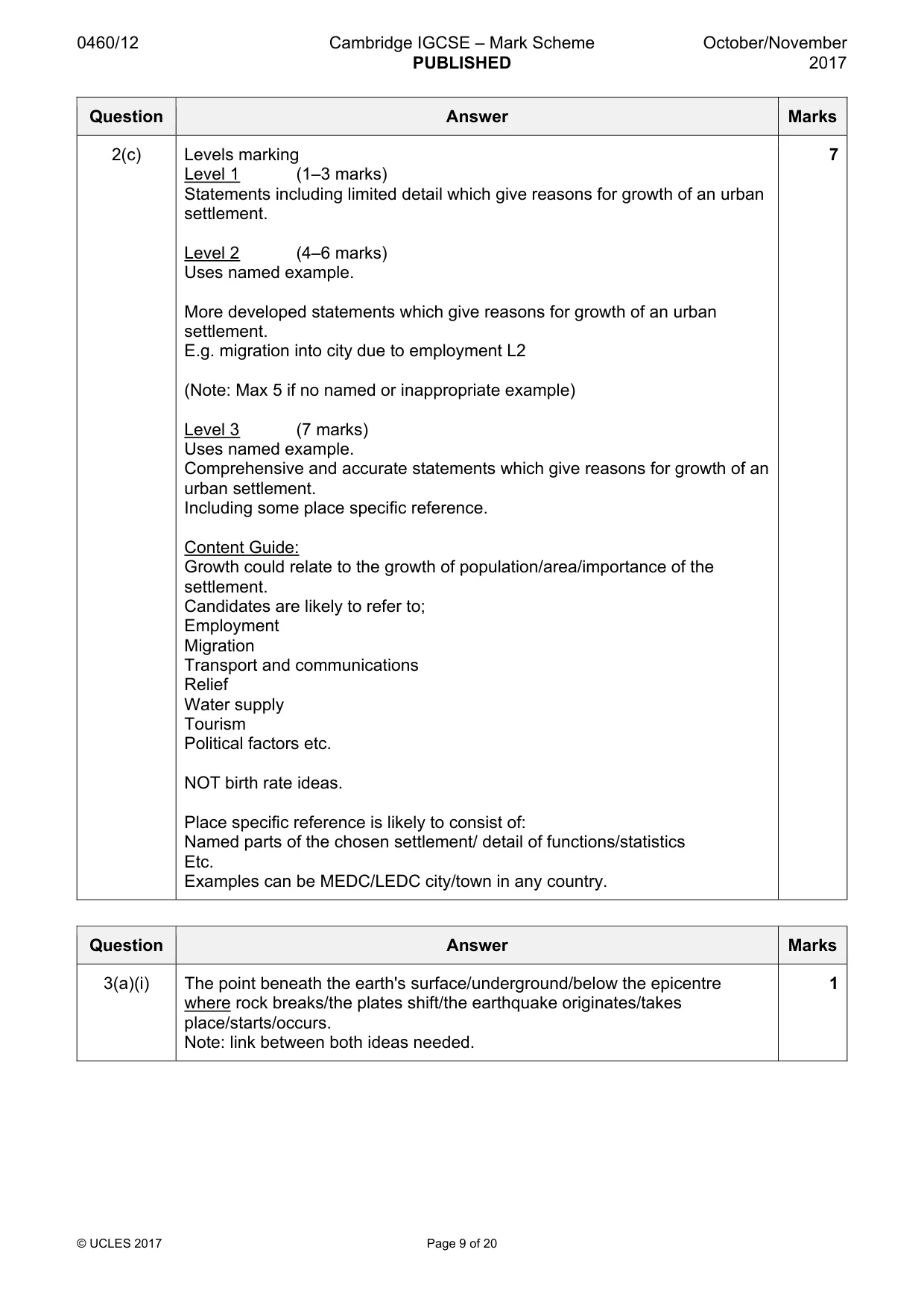
0460/12 Cambridge IGCSE – Mark Scheme PUBLISHED October/November 2017 © UCLES 2017 Page 9 of 20 Question Answer Marks 2(c) Levels marking Level 1 (1–3 marks) Statements including limited detail which give reasons for growth of an urban settlement. Level 2 (4–6 marks) Uses named example. More developed statements which give reasons for growth of an urban settlement. E.g. migration into city due to employment L2 (Note: Max 5 if no named or inappropriate example) Level 3 (7 marks) Uses named example. Comprehensive and accurate statements which give reasons for growth of an urban settlement. Including some place specific reference. Content Guide: Growth could relate to the growth of population/area/importance of the settlement. Candidates are likely to refer to; Employment Migration Transport and communications Relief Water supply Tourism Political factors etc. NOT birth rate ideas. Place specific reference is likely to consist of: Named parts of the chosen settlement/ detail of functions/statistics Etc. Examples can be MEDC/LEDC city/town in any country. 7 Question Answer Marks 3(a)(i) The point beneath the earth's surface/underground/below the epicentre where rock breaks/the plates shift/the earthquake originates/takes place/starts/occurs. Note: link between both ideas needed. 1
Mark scheme, page 10
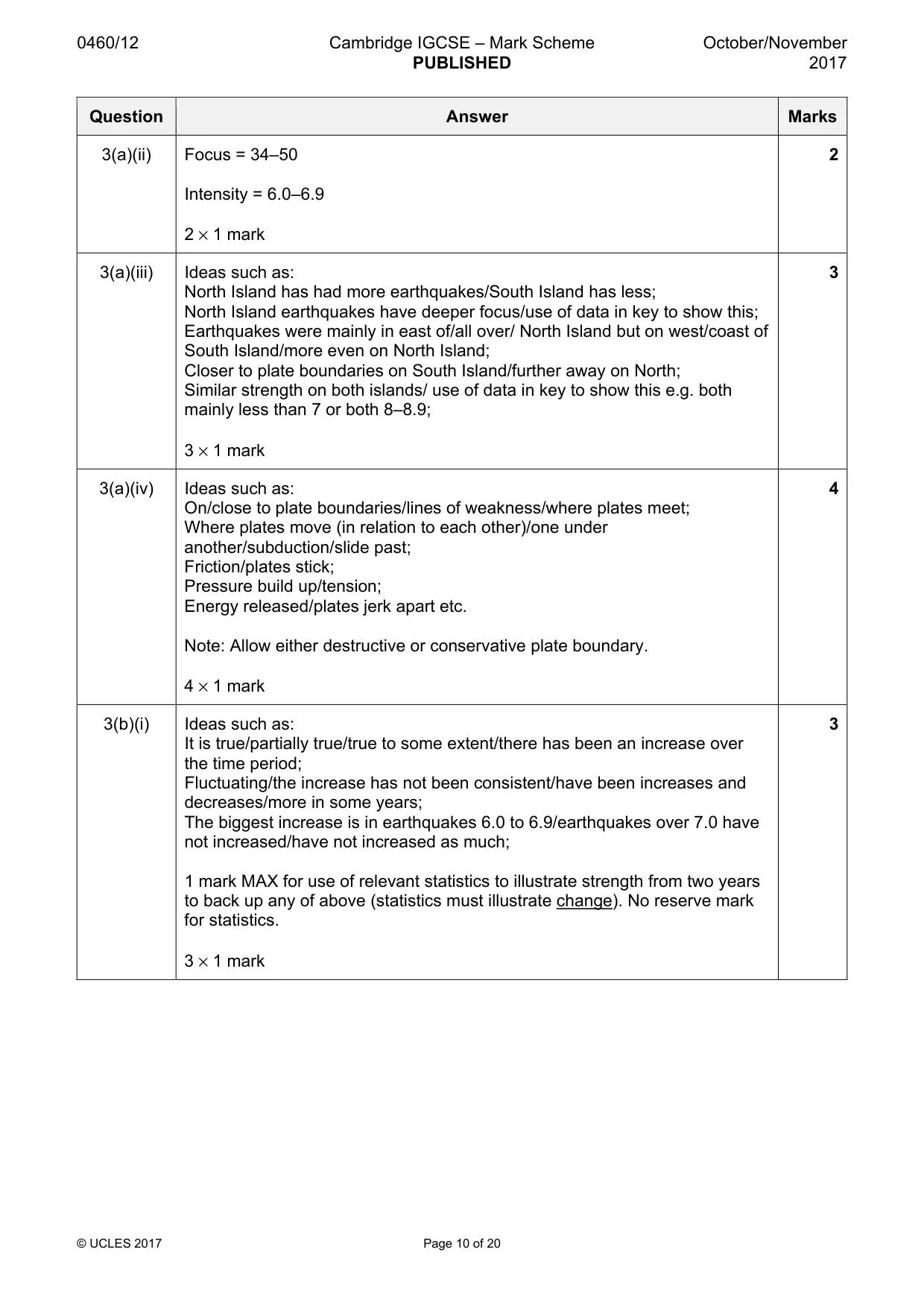
0460/12 Cambridge IGCSE – Mark Scheme PUBLISHED October/November 2017 © UCLES 2017 Page 10 of 20 Question Answer Marks 3(a)(ii) Focus = 34–50 Intensity = 6.0–6.9 2 × 1 mark 2 3(a)(iii) Ideas such as: North Island has had more earthquakes/South Island has less; North Island earthquakes have deeper focus/use of data in key to show this; Earthquakes were mainly in east of/all over/ North Island but on west/coast of South Island/more even on North Island; Closer to plate boundaries on South Island/further away on North; Similar strength on both islands/ use of data in key to show this e.g. both mainly less than 7 or both 8–8.9; 3 × 1 mark 3 3(a)(iv) Ideas such as: On/close to plate boundaries/lines of weakness/where plates meet; Where plates move (in relation to each other)/one under another/subduction/slide past; Friction/plates stick; Pressure build up/tension; Energy released/plates jerk apart etc. Note: Allow either destructive or conservative plate boundary. 4 × 1 mark 4 3(b)(i) Ideas such as: It is true/partially true/true to some extent/there has been an increase over the time period; Fluctuating/the increase has not been consistent/have been increases and decreases/more in some years; The biggest increase is in earthquakes 6.0 to 6.9/earthquakes over 7.0 have not increased/have not increased as much; 1 mark MAX for use of relevant statistics to illustrate strength from two years to back up any of above (statistics must illustrate change). No reserve mark for statistics. 3 × 1 mark 3
Mark scheme, page 11
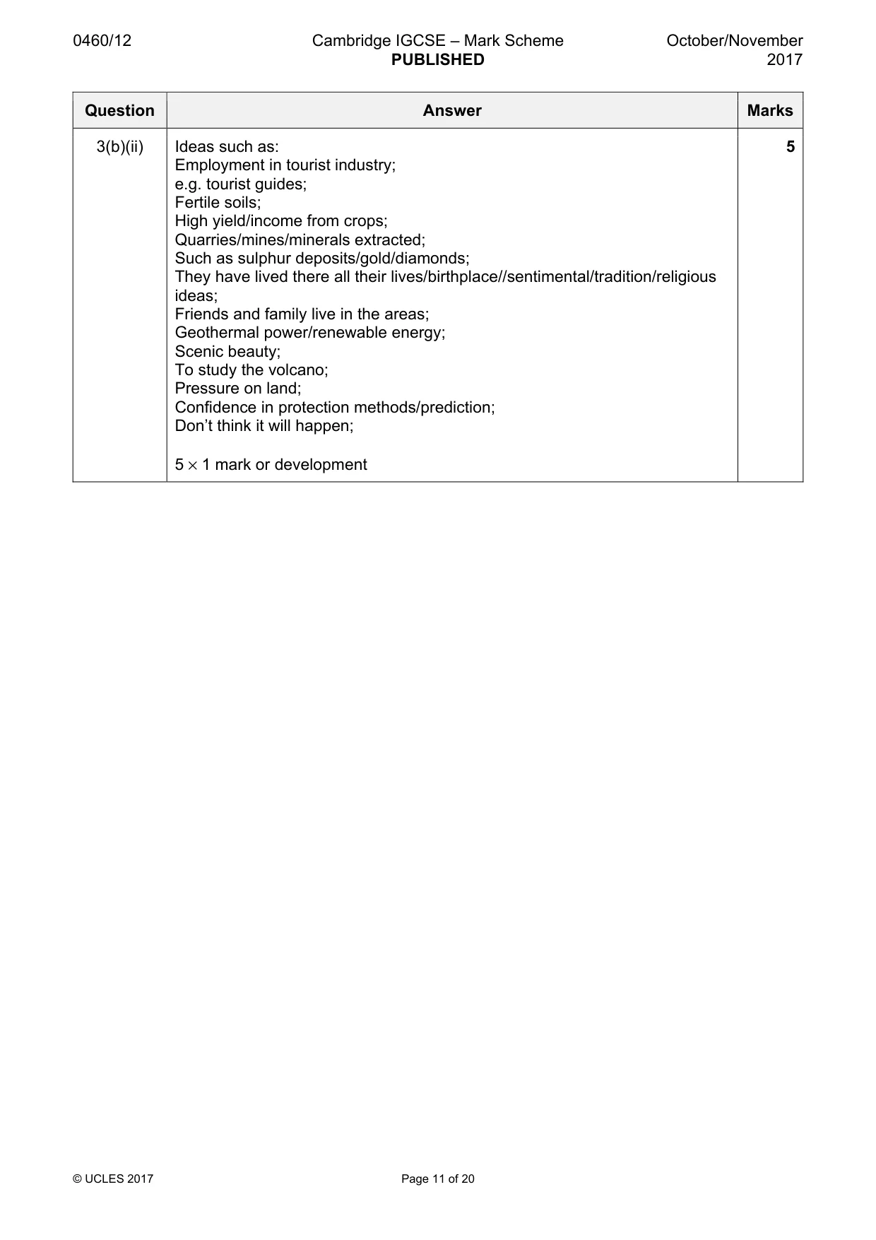
0460/12 Cambridge IGCSE – Mark Scheme PUBLISHED October/November 2017 © UCLES 2017 Page 11 of 20 Question Answer Marks 3(b)(ii) Ideas such as: Employment in tourist industry; e.g. tourist guides; Fertile soils; High yield/income from crops; Quarries/mines/minerals extracted; Such as sulphur deposits/gold/diamonds; They have lived there all their lives/birthplace//sentimental/tradition/religious ideas; Friends and family live in the areas; Geothermal power/renewable energy; Scenic beauty; To study the volcano; Pressure on land; Confidence in protection methods/prediction; Don’t think it will happen; 5 × 1 mark or development 5
Mark scheme, page 12
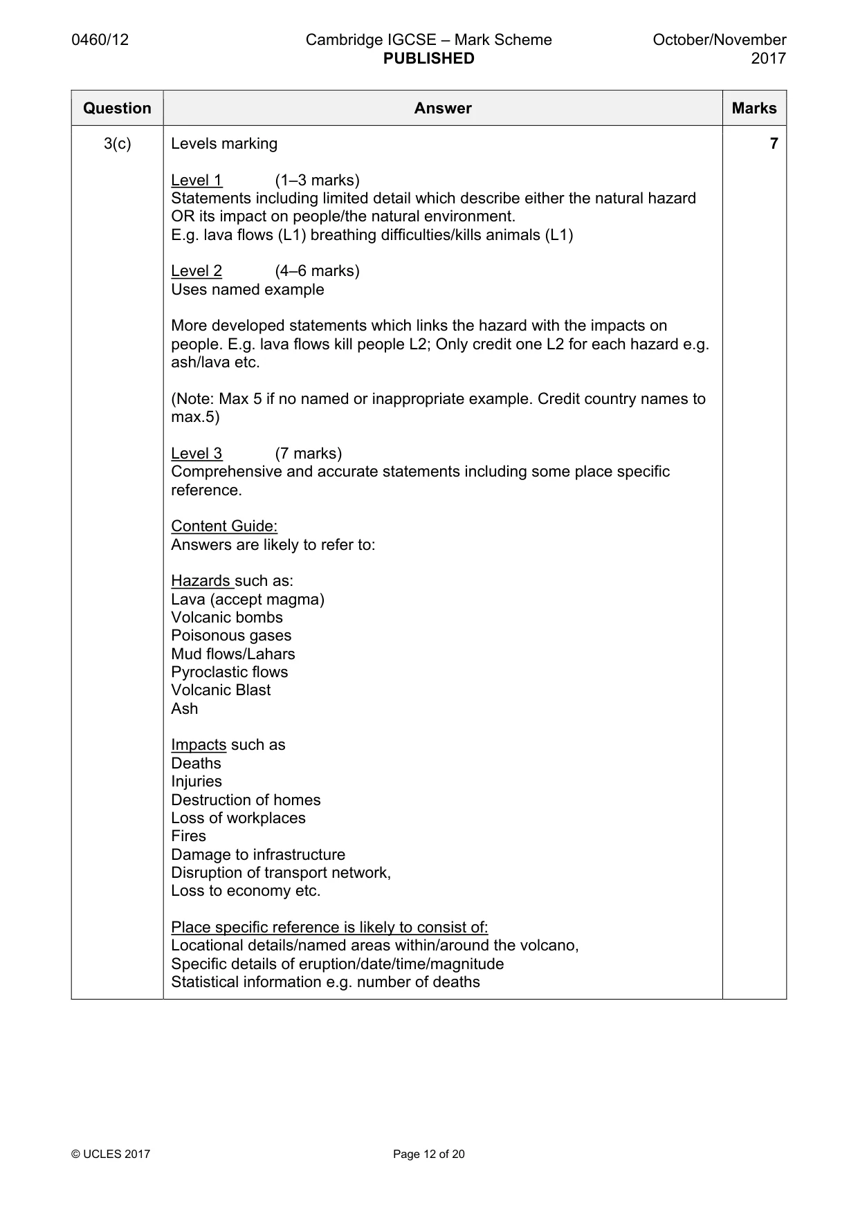
0460/12 Cambridge IGCSE – Mark Scheme PUBLISHED October/November 2017 © UCLES 2017 Page 12 of 20 Question Answer Marks 3(c) Levels marking Level 1 (1–3 marks) Statements including limited detail which describe either the natural hazard OR its impact on people/the natural environment. E.g. lava flows (L1) breathing difficulties/kills animals (L1) Level 2 (4–6 marks) Uses named example More developed statements which links the hazard with the impacts on people. E.g. lava flows kill people L2; Only credit one L2 for each hazard e.g. ash/lava etc. (Note: Max 5 if no named or inappropriate example. Credit country names to max.5) Level 3 (7 marks) Comprehensive and accurate statements including some place specific reference. Content Guide: Answers are likely to refer to: Hazards such as: Lava (accept magma) Volcanic bombs Poisonous gases Mud flows/Lahars Pyroclastic flows Volcanic Blast Ash Impacts such as Deaths Injuries Destruction of homes Loss of workplaces Fires Damage to infrastructure Disruption of transport network, Loss to economy etc. Place specific reference is likely to consist of: Locational details/named areas within/around the volcano, Specific details of eruption/date/time/magnitude Statistical information e.g. number of deaths 7
Mark scheme, page 13
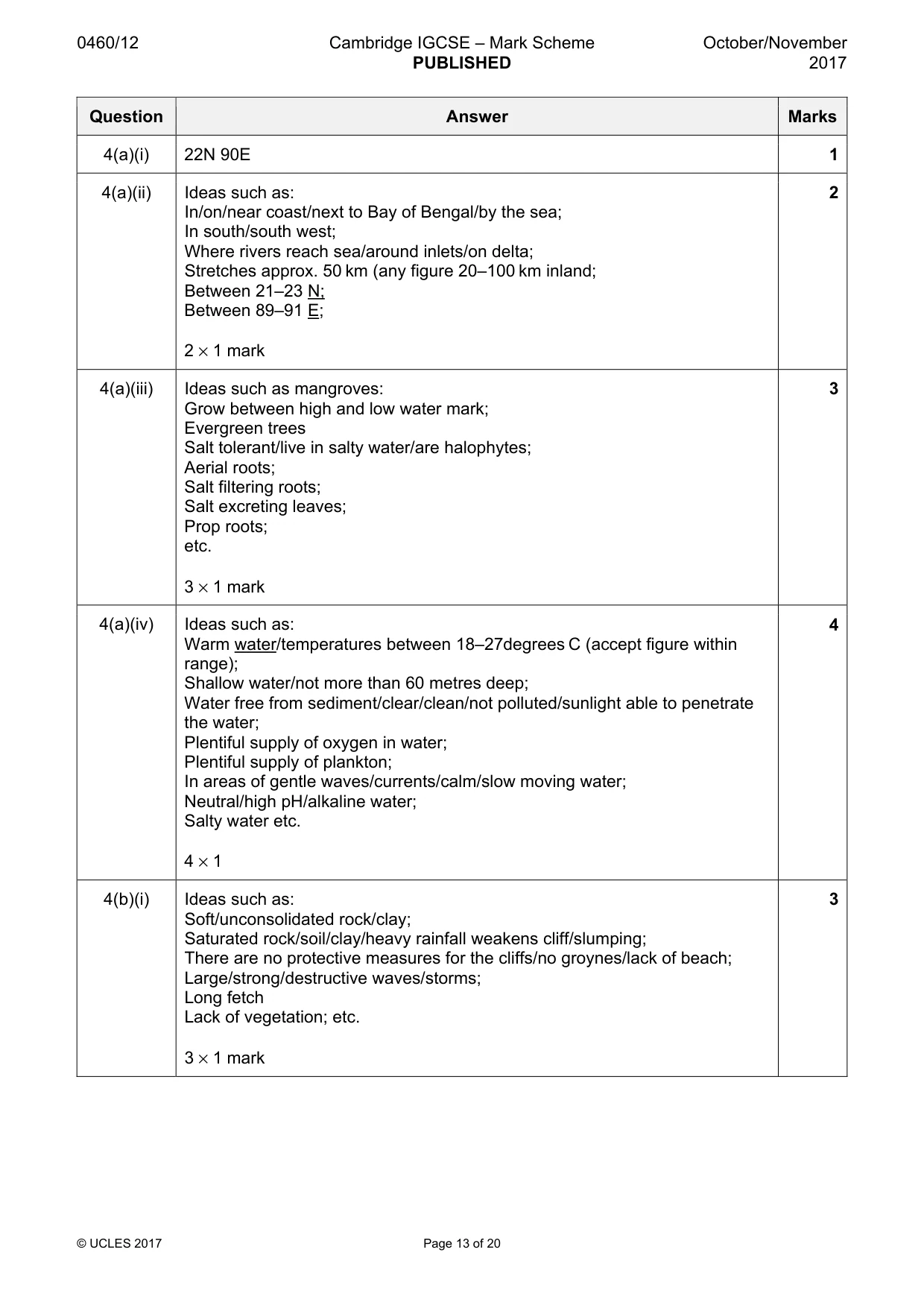
0460/12 Cambridge IGCSE – Mark Scheme PUBLISHED October/November 2017 © UCLES 2017 Page 13 of 20 Question Answer Marks 4(a)(i) 22N 90E 1 4(a)(ii) Ideas such as: In/on/near coast/next to Bay of Bengal/by the sea; In south/south west; Where rivers reach sea/around inlets/on delta; Stretches approx. 50 km (any figure 20–100 km inland; Between 21–23 N; Between 89–91 E; 2 × 1 mark 2 4(a)(iii) Ideas such as mangroves: Grow between high and low water mark; Evergreen trees Salt tolerant/live in salty water/are halophytes; Aerial roots; Salt filtering roots; Salt excreting leaves; Prop roots; etc. 3 × 1 mark 3 4(a)(iv) Ideas such as: Warm water/temperatures between 18–27degrees C (accept figure within range); Shallow water/not more than 60 metres deep; Water free from sediment/clear/clean/not polluted/sunlight able to penetrate the water; Plentiful supply of oxygen in water; Plentiful supply of plankton; In areas of gentle waves/currents/calm/slow moving water; Neutral/high pH/alkaline water; Salty water etc. 4 × 1 4 4(b)(i) Ideas such as: Soft/unconsolidated rock/clay; Saturated rock/soil/clay/heavy rainfall weakens cliff/slumping; There are no protective measures for the cliffs/no groynes/lack of beach; Large/strong/destructive waves/storms; Long fetch Lack of vegetation; etc. 3 × 1 mark 3
Mark scheme, page 14
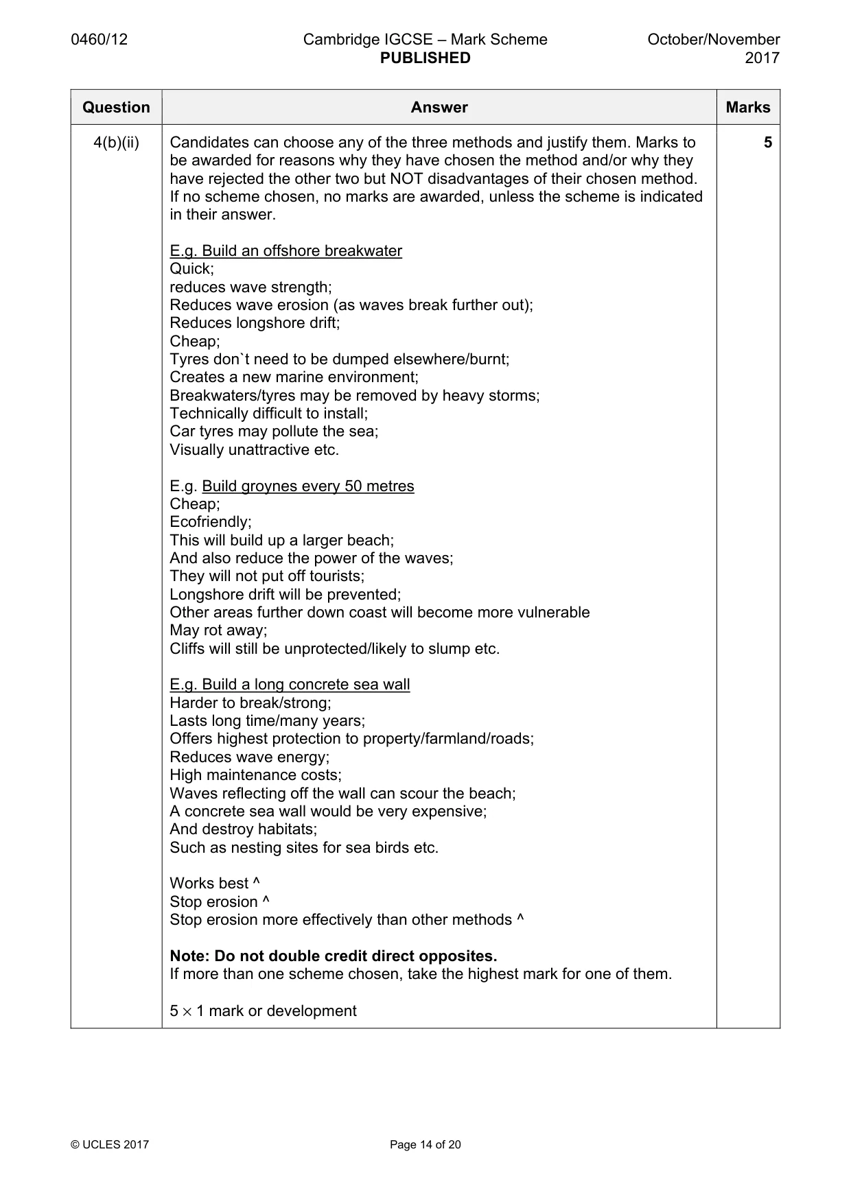
0460/12 Cambridge IGCSE – Mark Scheme PUBLISHED October/November 2017 © UCLES 2017 Page 14 of 20 Question Answer Marks 4(b)(ii) Candidates can choose any of the three methods and justify them. Marks to be awarded for reasons why they have chosen the method and/or why they have rejected the other two but NOT disadvantages of their chosen method. If no scheme chosen, no marks are awarded, unless the scheme is indicated in their answer. E.g. Build an offshore breakwater Quick; reduces wave strength; Reduces wave erosion (as waves break further out); Reduces longshore drift; Cheap; Tyres don`t need to be dumped elsewhere/burnt; Creates a new marine environment; Breakwaters/tyres may be removed by heavy storms; Technically difficult to install; Car tyres may pollute the sea; Visually unattractive etc. E.g. Build groynes every 50 metres Cheap; Ecofriendly; This will build up a larger beach; And also reduce the power of the waves; They will not put off tourists; Longshore drift will be prevented; Other areas further down coast will become more vulnerable May rot away; Cliffs will still be unprotected/likely to slump etc. E.g. Build a long concrete sea wall Harder to break/strong; Lasts long time/many years; Offers highest protection to property/farmland/roads; Reduces wave energy; High maintenance costs; Waves reflecting off the wall can scour the beach; A concrete sea wall would be very expensive; And destroy habitats; Such as nesting sites for sea birds etc. Works best ^ Stop erosion ^ Stop erosion more effectively than other methods ^ Note: Do not double credit direct opposites. If more than one scheme chosen, take the highest mark for one of them. 5 × 1 mark or development 5
Mark scheme, page 15
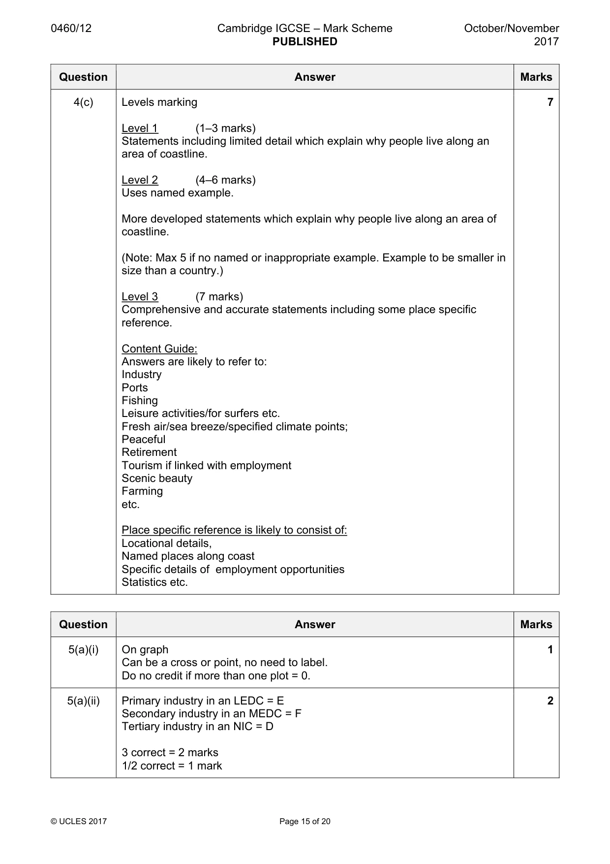
0460/12 Cambridge IGCSE – Mark Scheme PUBLISHED October/November 2017 © UCLES 2017 Page 15 of 20 Question Answer Marks 4(c) Levels marking Level 1 (1–3 marks) Statements including limited detail which explain why people live along an area of coastline. Level 2 (4–6 marks) Uses named example. More developed statements which explain why people live along an area of coastline. (Note: Max 5 if no named or inappropriate example. Example to be smaller in size than a country.) Level 3 (7 marks) Comprehensive and accurate statements including some place specific reference. Content Guide: Answers are likely to refer to: Industry Ports Fishing Leisure activities/for surfers etc. Fresh air/sea breeze/specified climate points; Peaceful Retirement Tourism if linked with employment Scenic beauty Farming etc. Place specific reference is likely to consist of: Locational details, Named places along coast Specific details of employment opportunities Statistics etc. 7 Question Answer Marks 5(a)(i) On graph Can be a cross or point, no need to label. Do no credit if more than one plot = 0. 1 5(a)(ii) Primary industry in an LEDC = E Secondary industry in an MEDC = F Tertiary industry in an NIC = D 3 correct = 2 marks 1/2 correct = 1 mark 2
Mark scheme, page 16
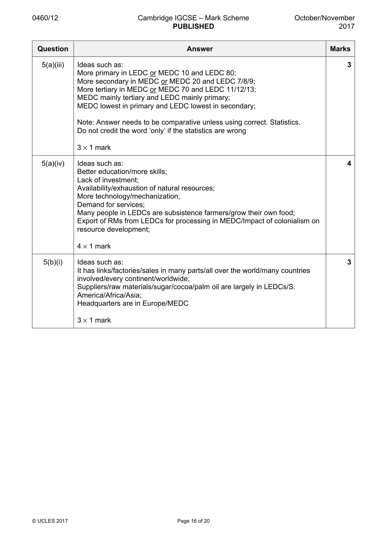
0460/12 Cambridge IGCSE – Mark Scheme PUBLISHED October/November 2017 © UCLES 2017 Page 16 of 20 Question Answer Marks 5(a)(iii) Ideas such as: More primary in LEDC or MEDC 10 and LEDC 80; More secondary in MEDC or MEDC 20 and LEDC 7/8/9; More tertiary in MEDC or MEDC 70 and LEDC 11/12/13; MEDC mainly tertiary and LEDC mainly primary; MEDC lowest in primary and LEDC lowest in secondary; Note: Answer needs to be comparative unless using correct. Statistics. Do not credit the word ‘only’ if the statistics are wrong 3 × 1 mark 3 5(a)(iv) Ideas such as: Better education/more skills; Lack of investment; Availability/exhaustion of natural resources; More technology/mechanization; Demand for services; Many people in LEDCs are subsistence farmers/grow their own food; Export of RMs from LEDCs for processing in MEDC/Impact of colonialism on resource development; 4 × 1 mark 4 5(b)(i) Ideas such as: It has links/factories/sales in many parts/all over the world/many countries involved/every continent/worldwide; Suppliers/raw materials/sugar/cocoa/palm oil are largely in LEDCs/S. America/Africa/Asia; Headquarters are in Europe/MEDC 3 × 1 mark 3
Mark scheme, page 17
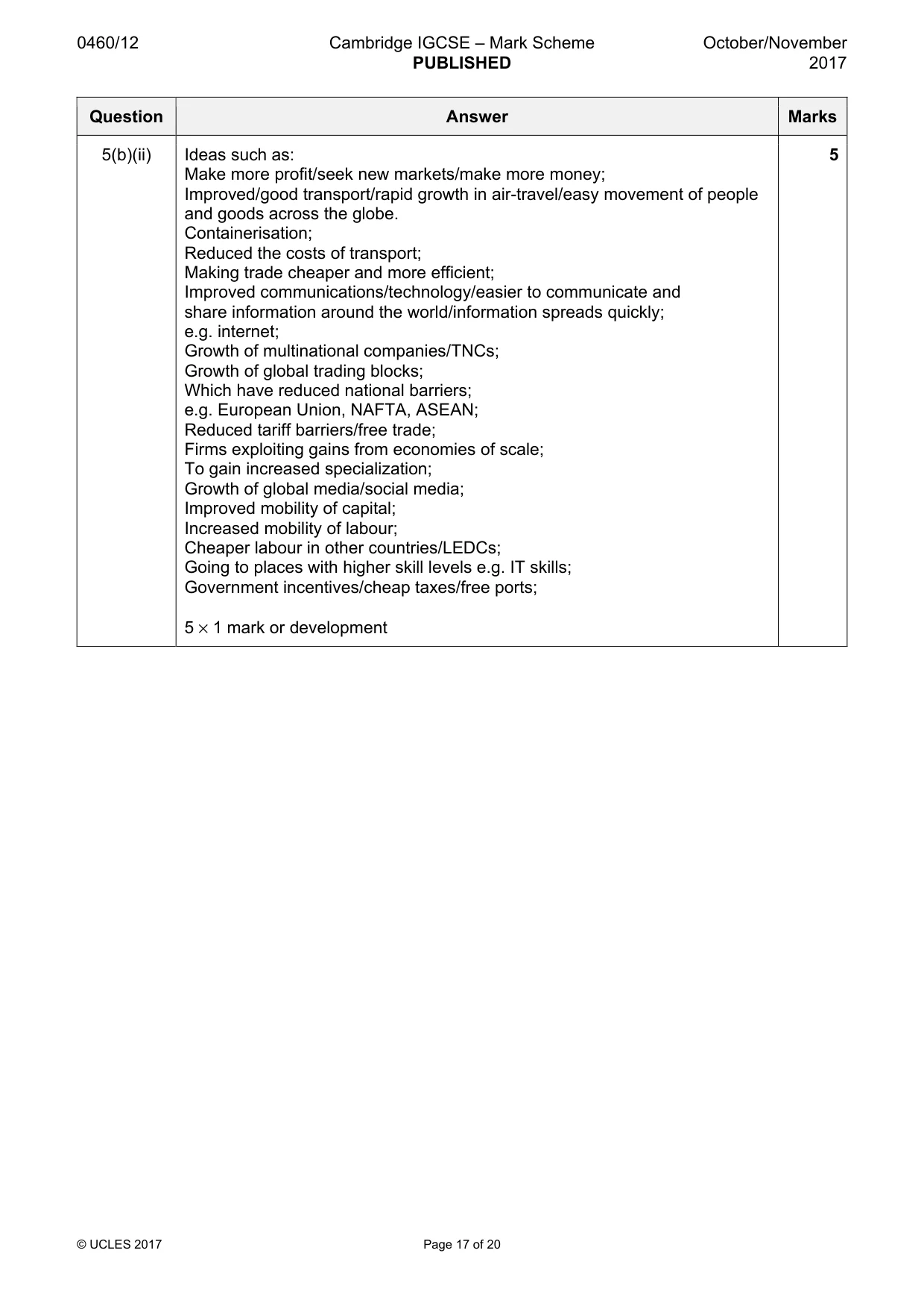
0460/12 Cambridge IGCSE – Mark Scheme PUBLISHED October/November 2017 © UCLES 2017 Page 17 of 20 Question Answer Marks 5(b)(ii) Ideas such as: Make more profit/seek new markets/make more money; Improved/good transport/rapid growth in air-travel/easy movement of people and goods across the globe. Containerisation; Reduced the costs of transport; Making trade cheaper and more efficient; Improved communications/technology/easier to communicate and share information around the world/information spreads quickly; e.g. internet; Growth of multinational companies/TNCs; Growth of global trading blocks; Which have reduced national barriers; e.g. European Union, NAFTA, ASEAN; Reduced tariff barriers/free trade; Firms exploiting gains from economies of scale; To gain increased specialization; Growth of global media/social media; Improved mobility of capital; Increased mobility of labour; Cheaper labour in other countries/LEDCs; Going to places with higher skill levels e.g. IT skills; Government incentives/cheap taxes/free ports; 5 × 1 mark or development 5
Mark scheme, page 18
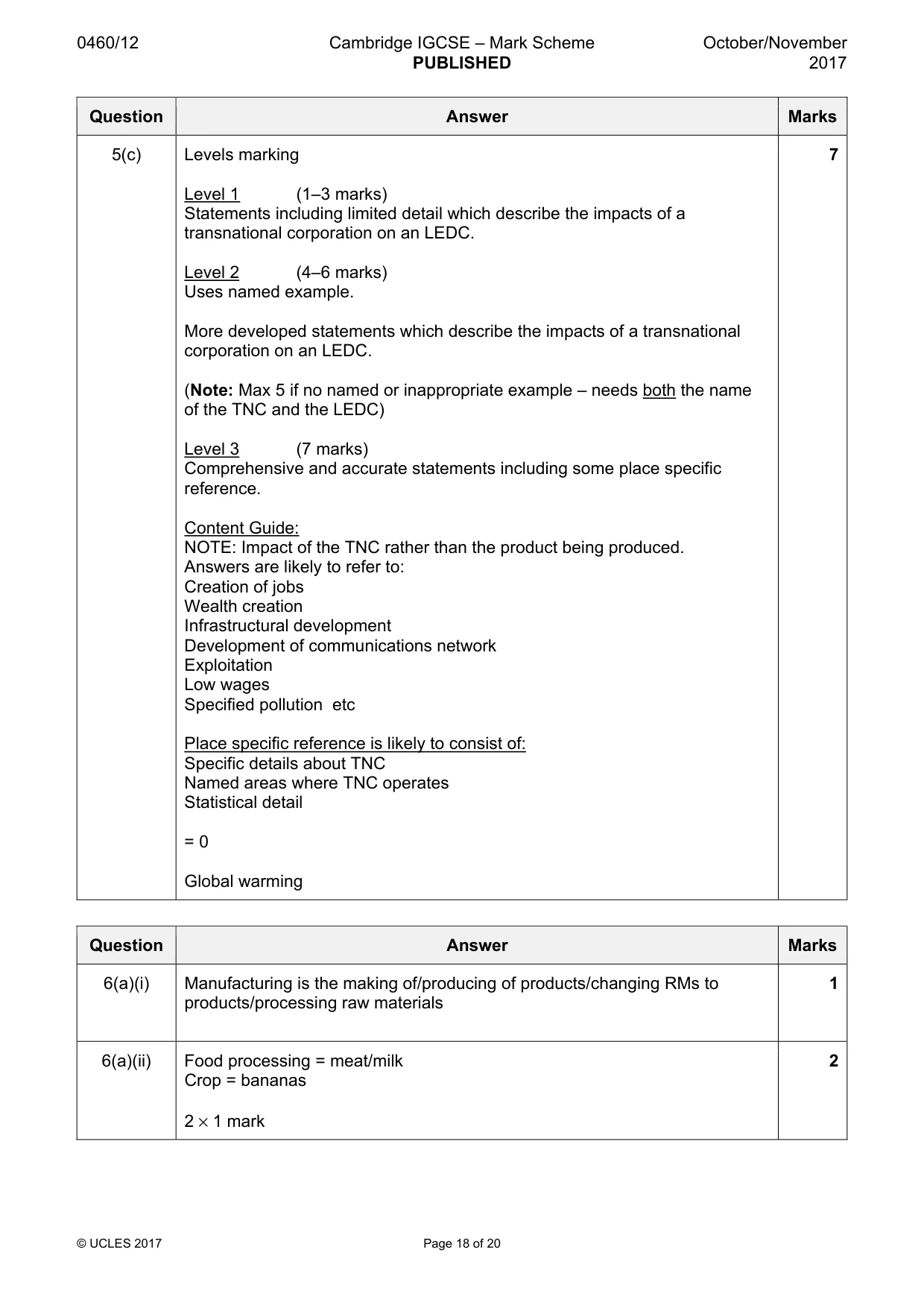
0460/12 Cambridge IGCSE – Mark Scheme PUBLISHED October/November 2017 © UCLES 2017 Page 18 of 20 Question Answer Marks 5(c) Levels marking Level 1 (1–3 marks) Statements including limited detail which describe the impacts of a transnational corporation on an LEDC. Level 2 (4–6 marks) Uses named example. More developed statements which describe the impacts of a transnational corporation on an LEDC. (Note: Max 5 if no named or inappropriate example – needs both the name of the TNC and the LEDC) Level 3 (7 marks) Comprehensive and accurate statements including some place specific reference. Content Guide: NOTE: Impact of the TNC rather than the product being produced. Answers are likely to refer to: Creation of jobs Wealth creation Infrastructural development Development of communications network Exploitation Low wages Specified pollution etc Place specific reference is likely to consist of: Specific details about TNC Named areas where TNC operates Statistical detail = 0 Global warming 7 Question Answer Marks 6(a)(i) Manufacturing is the making of/producing of products/changing RMs to products/processing raw materials 1 6(a)(ii) Food processing = meat/milk Crop = bananas 2 × 1 mark 2
Mark scheme, page 19
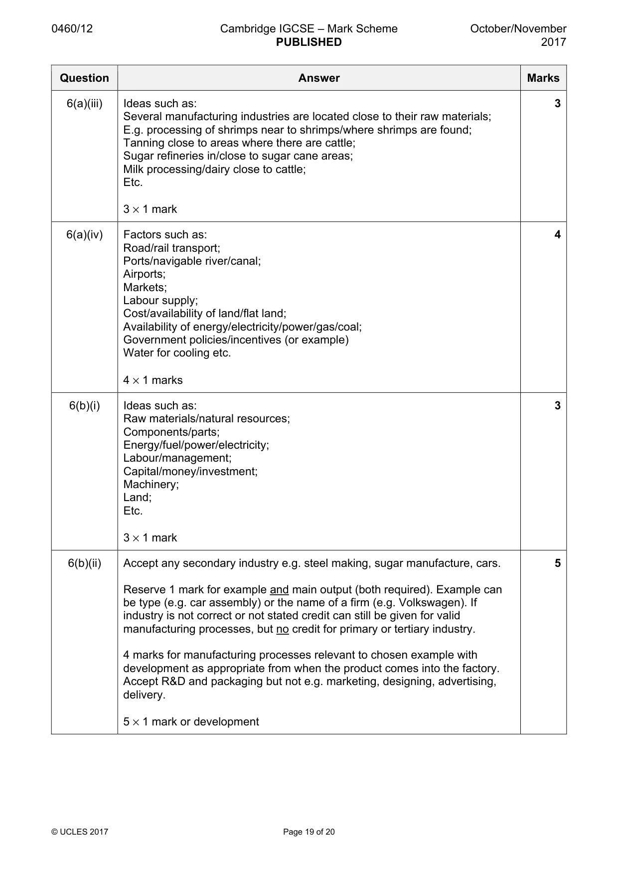
0460/12 Cambridge IGCSE – Mark Scheme PUBLISHED October/November 2017 © UCLES 2017 Page 19 of 20 Question Answer Marks 6(a)(iii) Ideas such as: Several manufacturing industries are located close to their raw materials; E.g. processing of shrimps near to shrimps/where shrimps are found; Tanning close to areas where there are cattle; Sugar refineries in/close to sugar cane areas; Milk processing/dairy close to cattle; Etc. 3 × 1 mark 3 6(a)(iv) Factors such as: Road/rail transport; Ports/navigable river/canal; Airports; Markets; Labour supply; Cost/availability of land/flat land; Availability of energy/electricity/power/gas/coal; Government policies/incentives (or example) Water for cooling etc. 4 × 1 marks 4 6(b)(i) Ideas such as: Raw materials/natural resources; Components/parts; Energy/fuel/power/electricity; Labour/management; Capital/money/investment; Machinery; Land; Etc. 3 × 1 mark 3 6(b)(ii) Accept any secondary industry e.g. steel making, sugar manufacture, cars. Reserve 1 mark for example and main output (both required). Example can be type (e.g. car assembly) or the name of a firm (e.g. Volkswagen). If industry is not correct or not stated credit can still be given for valid manufacturing processes, but no credit for primary or tertiary industry. 4 marks for manufacturing processes relevant to chosen example with development as appropriate from when the product comes into the factory. Accept R&D and packaging but not e.g. marketing, designing, advertising, delivery. 5 × 1 mark or development 5
Mark scheme, page 20
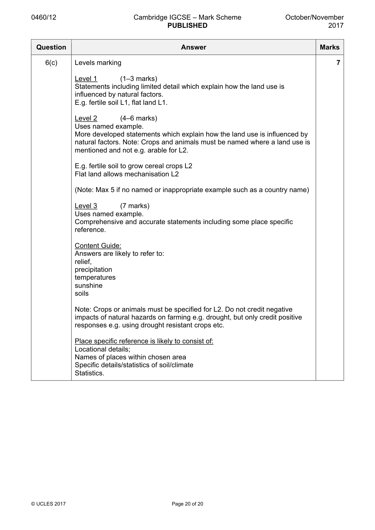
0460/12 Cambridge IGCSE – Mark Scheme PUBLISHED October/November 2017 © UCLES 2017 Page 20 of 20 Question Answer Marks 6(c) Levels marking Level 1 (1–3 marks) Statements including limited detail which explain how the land use is influenced by natural factors. E.g. fertile soil L1, flat land L1. Level 2 (4–6 marks) Uses named example. More developed statements which explain how the land use is influenced by natural factors. Note: Crops and animals must be named where a land use is mentioned and not e.g. arable for L2. E.g. fertile soil to grow cereal crops L2 Flat land allows mechanisation L2 (Note: Max 5 if no named or inappropriate example such as a country name) Level 3 (7 marks) Uses named example. Comprehensive and accurate statements including some place specific reference. Content Guide: Answers are likely to refer to: relief, precipitation temperatures sunshine soils Note: Crops or animals must be specified for L2. Do not credit negative impacts of natural hazards on farming e.g. drought, but only credit positive responses e.g. using drought resistant crops etc. Place specific reference is likely to consist of: Locational details; Names of places within chosen area Specific details/statistics of soil/climate Statistics. 7
What you needed in this session
Cambridge’s own grade thresholds for 2017 Oct/Nov, Paper 1 · Variant 2. A higher threshold means an easier paper — the bar moves with how the cohort did.