Cambridge IGCSE Geography 0460 — 2017 May/June Paper 1 · Variant 1
0460/11/M/J/17 · 75 marks · ≈84 min
The question paper and its mark scheme, free to read here and free to download. This is Cambridge’s own paper, exactly as it was sat.
Question paper32 pages






Mark scheme16 pages
Answers below. Sit the paper first if you are practising.
Paper as text
Question paper, page 1
This document consists of 30 printed pages, 2 blank pages and 1 Insert. DC (NF/SW) 130433/4 © UCLES 2017 [Turn over Cambridge International Examinations Cambridge International General Certificate of Secondary Education * 8 2 6 9 2 1 2 9 0 5 * GEOGRAPHY 0460/11 Paper 1 May/June 2017 1 hour 45 minutes Candidates answer on the Question Paper. Additional Materials: Ruler Calculator READ THESE INSTRUCTIONS FIRST Write your Centre number, candidate number and name in the spaces provided. Write in dark blue or black pen. You may use an HB pencil for any diagrams or graphs. Do not use staples, paper clips, glue or correction fluid. DO NOT WRITE IN ANY BARCODES. Write your answer to each question in the space provided. If additional space is required, you should use the lined pages at the end of this booklet. The question number(s) must be clearly shown. Answer three questions, one from each section. The Insert contains Photographs A and B for Question 3, Photograph C and Fig. 5 for Question 4, Fig. 6 for Question 5 and Photograph D for Question 6. The Insert is not required by the Examiner. Sketch maps and diagrams should be drawn whenever they serve to illustrate an answer. At the end of the examination, fasten all your work securely together. The number of marks is given in brackets [ ] at the end of each question or part question. Definitions MEDCs – More Economically Developed Countries LEDCs – Less Economically Developed Countries The syllabus is approved for use in England, Wales and Northern Ireland as a Cambridge International Level 1/Level 2 Certificate.
Question paper, page 2
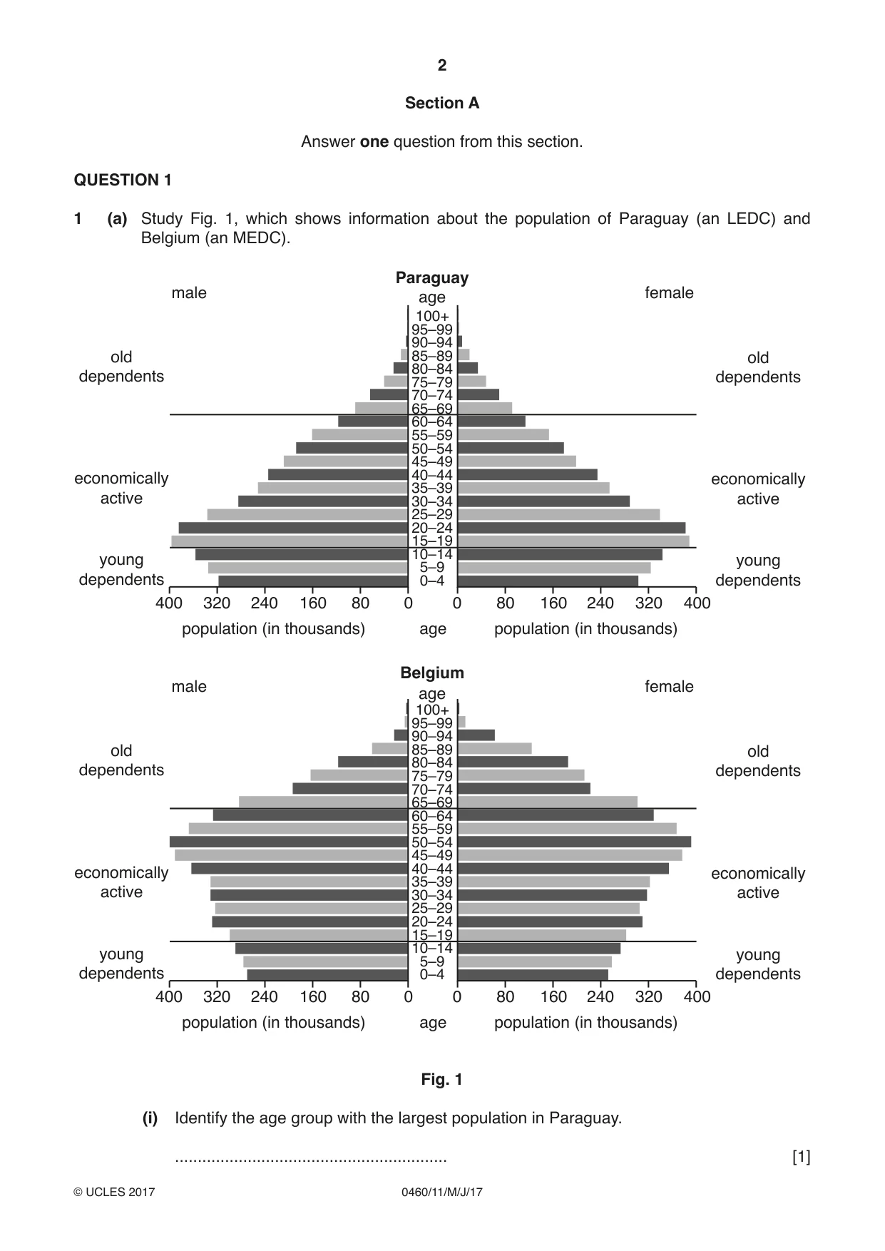
2 0460/11/M/J/17 © UCLES 2017 Section A Answer one question from this section. QUESTION 1 1 (a) Study Fig. 1, which shows information about the population of Paraguay (an LEDC) and Belgium (an MEDC). 0 0 80 80 160 population (in thousands) population (in thousands) age 160 240 240 320 320 400 400 young dependents economically active old dependents 100+ 95–99 90–94 85–89 80–84 75–79 70–74 65–69 60–64 55–59 50–54 45–49 40–44 35–39 30–34 25–29 20–24 15–19 10–14 5–9 0–4 age Paraguay male female 0 0 80 80 160 population (in thousands) population (in thousands) age 160 240 240 320 320 400 400 young dependents economically active old dependents young dependents economically active old dependents young dependents economically active old dependents 100+ 95–99 90–94 85–89 80–84 75–79 70–74 65–69 60–64 55–59 50–54 45–49 40–44 35–39 30–34 25–29 20–24 15–19 10–14 5–9 0–4 age Belgium male female Fig. 1 (i) Identify the age group with the largest population in Paraguay. … [1]
Question paper, page 3
3 0460/11/M/J/17 © UCLES 2017 [Turn over (ii) Describe two differences between the shape of the population pyramids of Paraguay and Belgium. 1 … … 2 … … [2] (iii) Give three reasons why the number of young dependents in LEDCs such as Paraguay is high. 1 … … 2 … … 3 … … [3] (iv) Explain why there is a large number of old dependents in MEDCs such as Belgium. … … … … … … … … [4]
Question paper, page 4
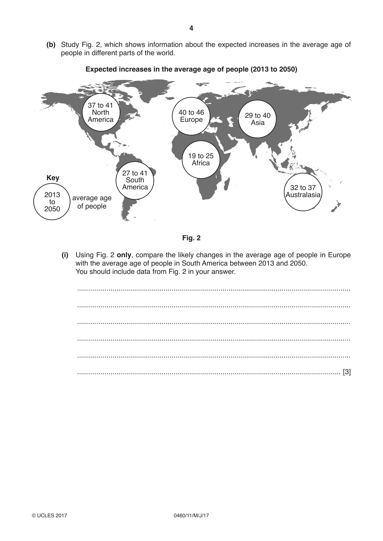
4 0460/11/M/J/17 © UCLES 2017 (b) Study Fig. 2, which shows information about the expected increases in the average age of people in different parts of the world. 37 to 41 North America 40 to 46 Europe Expected increases in the average age of people (2013 to 2050) 29 to 40 Asia 32 to 37 Australasia 19 to 25 Africa 2013 to 2050 average age of people Key 27 to 41 South America Fig. 2 (i) Using Fig. 2 only, compare the likely changes in the average age of people in Europe with the average age of people in South America between 2013 and 2050. You should include data from Fig. 2 in your answer. … … … … … … [3]
Question paper, page 5
5 0460/11/M/J/17 © UCLES 2017 [Turn over (ii) Explain why an increase in the percentage of old dependents may cause problems for a country. … … … … … … … … … … [5]
Question paper, page 6
6 0460/11/M/J/17 © UCLES 2017 (c) For a named country you have studied, explain why the natural population growth rate is low. Name of country … … … … … … … … … … … … … … … … … … … … … … … … [7] [Total: 25 marks] END OF QUESTION 1
Question paper, page 7
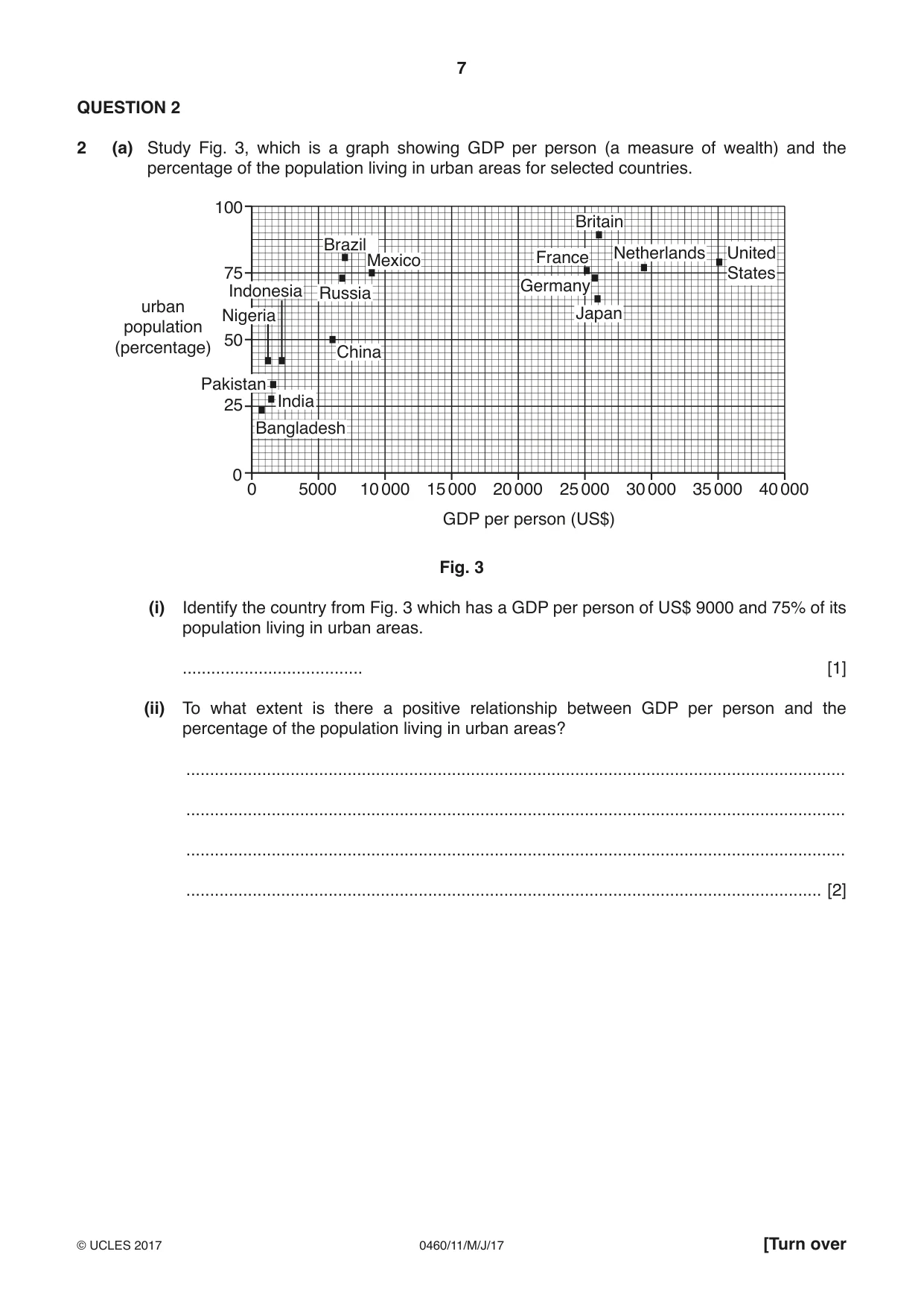
7 0460/11/M/J/17 © UCLES 2017 [Turn over QUESTION 2 2 (a) Study Fig. 3, which is a graph showing GDP per person (a measure of wealth) and the percentage of the population living in urban areas for selected countries. 5000 0 0 25 50 75 100 10 000 15 000 20 000 25 000 GDP per person (US$) urban population (percentage) 30 000 35 000 40 000 United States Netherlands Britain France Mexico China India Pakistan Bangladesh Brazil Russia Germany Japan Nigeria Indonesia Fig. 3 (i) Identify the country from Fig. 3 which has a GDP per person of US$ 9000 and 75% of its population living in urban areas. … [1] (ii) To what extent is there a positive relationship between GDP per person and the percentage of the population living in urban areas? … … … … [2]
Question paper, page 8
8 0460/11/M/J/17 © UCLES 2017 (iii) Give three different reasons why large numbers of people are migrating from urban areas to rural areas in MEDCs. 1 … … 2 … … 3 … … [3] (iv) Explain why the percentage of the population living in urban areas in LEDCs is increasing. … … … … … … … … [4]
Question paper, page 9
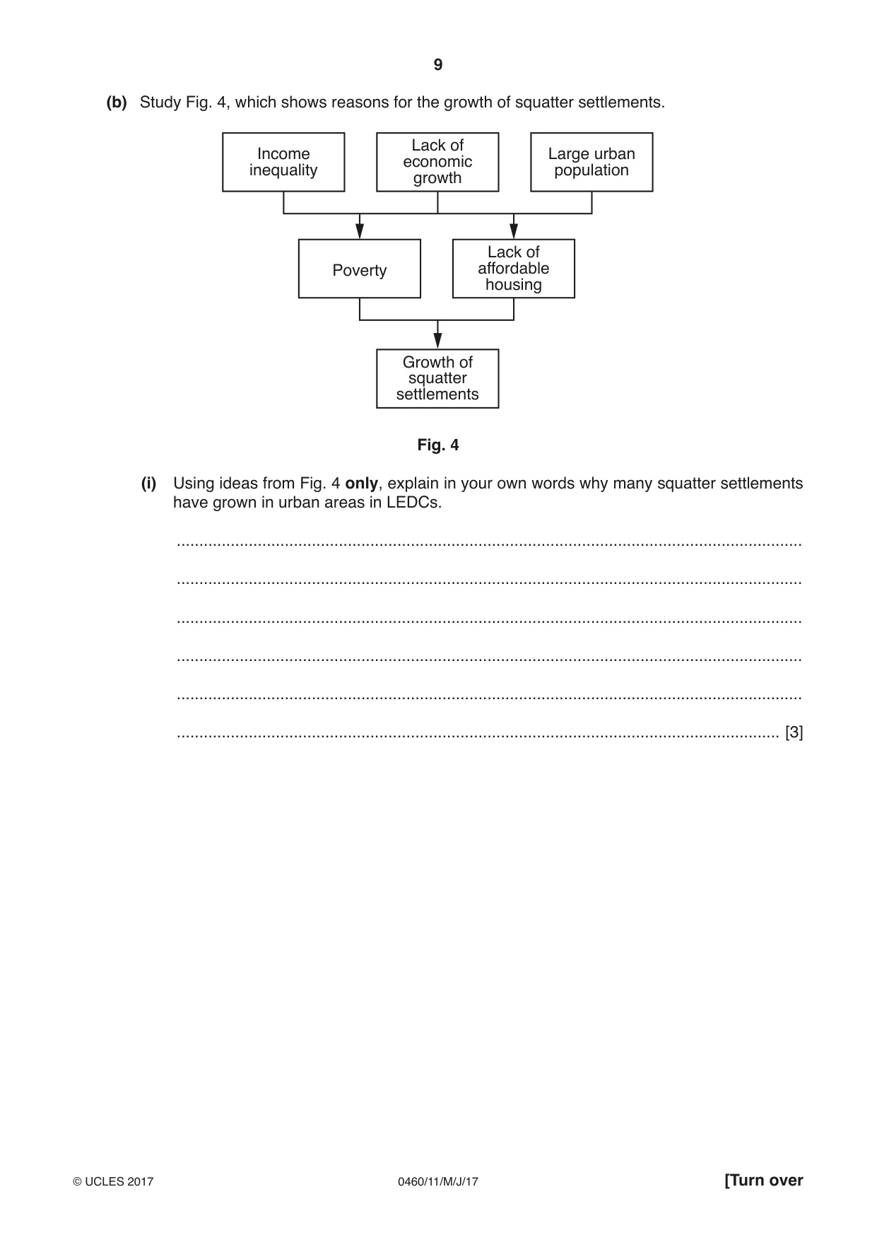
9 0460/11/M/J/17 © UCLES 2017 [Turn over (b) Study Fig. 4, which shows reasons for the growth of squatter settlements. Income inequality Lack of economic growth Poverty Lack of affordable housing Growth of squatter settlements Large urban population Fig. 4 (i) Using ideas from Fig. 4 only, explain in your own words why many squatter settlements have grown in urban areas in LEDCs. … … … … … … [3]
Question paper, page 10
10 0460/11/M/J/17 © UCLES 2017 (ii) Describe the problems of living in a squatter settlement. … … … … … … … … … … [5]
Question paper, page 11
11 0460/11/M/J/17 © UCLES 2017 [Turn over (c) For an urban area you have studied, describe the strategies used to reduce problems caused by the growth of squatter settlements. Name of urban area … … … … … … … … … … … … … … … … … … … … … … … … [7] [Total: 25 marks] END OF QUESTION 2
Question paper, page 12
12 0460/11/M/J/17 © UCLES 2017 Section B Answer one question from this section. QUESTION 3 3 (a) Study Photograph A (Insert), which shows a coastal landform. (i) Name the landform shown in Photograph A. Choose from the landforms below and circle your answer. Arch Cave Spit Stack [1] (ii) Describe the landform shown in Photograph A. … … … … [2] (iii) Suggest how the landform shown in Photograph A was formed by coastal erosion. … … … … … … [3]
Question paper, page 13
13 0460/11/M/J/17 © UCLES 2017 [Turn over (iv) Explain how the landform shown in Photograph A may change in the future as a result of natural processes. … … … … … … .. … … [4] (b) Study Photograph B (Insert), which shows an area where coastal erosion is occurring. (i) Suggest three problems which are likely to be faced by people living in the area shown in Photograph B as a result of coastal erosion. 1 … … 2 … … 3 … … [3]
Question paper, page 14
14 0460/11/M/J/17 © UCLES 2017 (ii) Explain why many people live on or close to the coast even though it may be hazardous. … … … … … … … … … … [5]
Question paper, page 15
15 0460/11/M/J/17 © UCLES 2017 [Turn over (c) Explain how a sand spit is formed. You should include a labelled diagram or series of diagrams. … … … … … … … … … … … … … [7] [Total: 25 marks] END OF QUESTION 3
Question paper, page 16
16 0460/11/M/J/17 © UCLES 2017 QUESTION 4 4 (a) Study Photograph C (Insert), which shows a river landform. (i) Name the landform shown in Photograph C. Choose from the landforms below and circle your answer. Delta Levee Rapids Waterfall [1] (ii) Describe the landform shown in Photograph C. … … … … [2] (iii) Suggest how the landform shown in Photograph C was formed by river erosion. … … … … … … [3]
Question paper, page 17
17 0460/11/M/J/17 © UCLES 2017 [Turn over (iv) Explain how the landform shown in Photograph C may change in the future as a result of natural processes. … … … … … … … … [4]
Question paper, page 18
18 0460/11/M/J/17 © UCLES 2017 (b) Study Fig. 5 (Insert), which shows an area close to the Fraser River in British Columbia, Canada (an MEDC). (i) Using evidence from Fig. 5 only, suggest three problems which flooding of the Fraser River may cause. 1 … … 2 … … 3 … … [3]
Question paper, page 19
19 0460/11/M/J/17 © UCLES 2017 [Turn over (ii) Explain why many people live near to rivers even though it may be hazardous. … … … … … … … … … … [5]
Question paper, page 20
20 0460/11/M/J/17 © UCLES 2017 (c) For a named river you have studied, explain the causes of flooding. Name of river … … … … … … … … … … … … … … … … … … … … … … … … [7] [Total: 25 marks] END OF QUESTION 4
Question paper, page 21
21 0460/11/M/J/17 © UCLES 2017 [Turn over Section C Answer one question from this section. QUESTION 5 5 (a) Study Fig. 6 (Insert), which shows information about electricity generation in France. (i) How much electricity was generated in total in France in 2012? … TWh [1] (ii) Using Fig. 6 only, identify: – a fossil fuel used to generate electricity in France; … – a renewable form of energy used in France. … [2] (iii) Using Fig. 6 only, describe three changes in the importance of different methods of generating electricity in France between 1972 and 2012. 1 … … 2 … … 3 … … [3] (iv) Explain how a country can benefit by generating electricity using renewable forms of energy rather than by using fossil fuels. … … … … … … … … [4]
Question paper, page 22
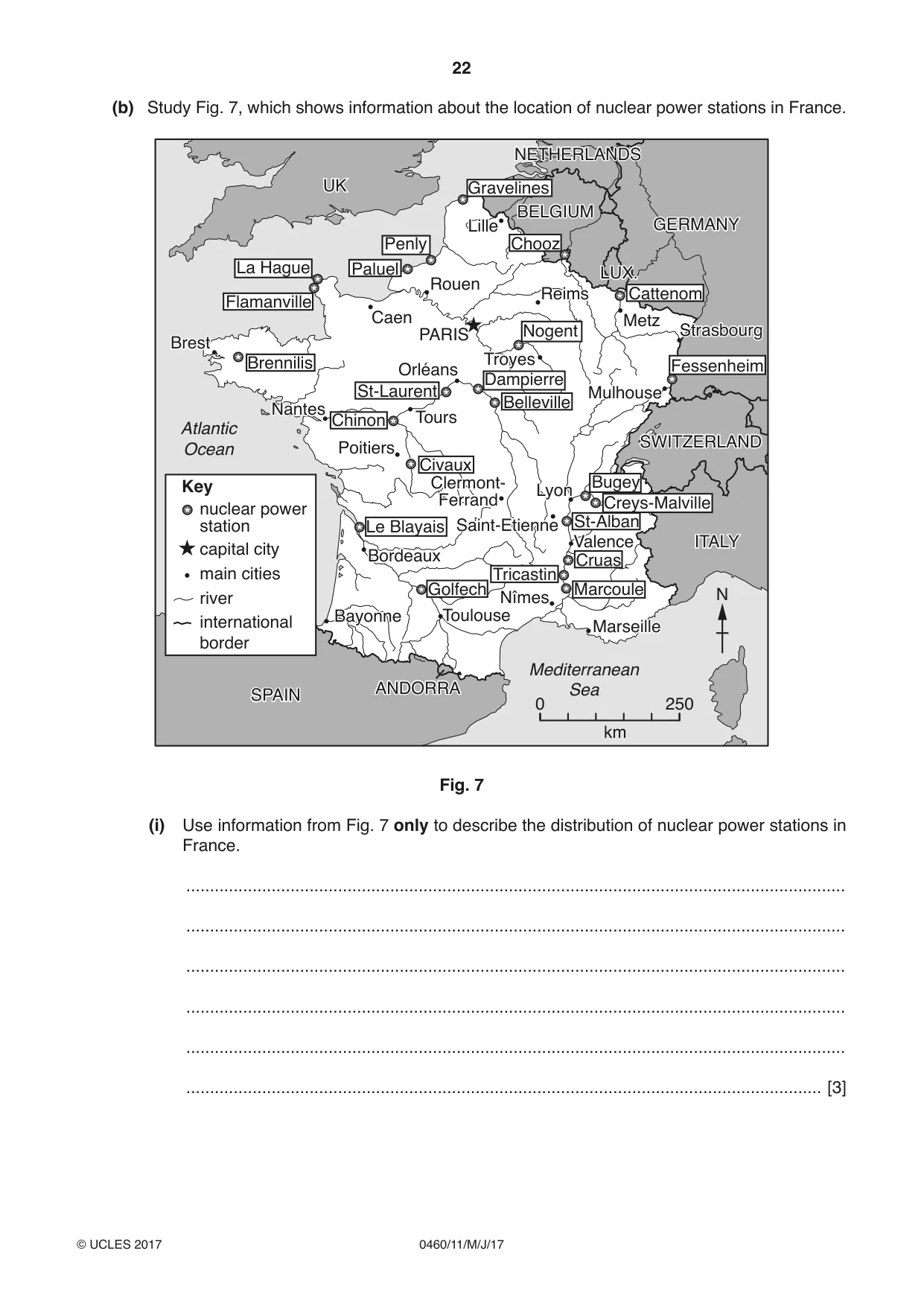
22 0460/11/M/J/17 © UCLES 2017 (b) Study Fig. 7, which shows information about the location of nuclear power stations in France. Civaux Chinon Brennilis St-Laurent Belleville Dampierre Nogent Paluel La Hague Flamanville Penly Gravelines UK ITALY Lille Reims Tours Caen Rouen Poitiers Bayonne Toulouse Valence Saint-Etienne Clermont- Ferrand Lyon Nîmes Orléans PARIS BELGIUM GERMANY Troyes Metz Mulhouse SPAIN ANDORRA Brest Nantes Bordeaux Marseille Mediterranean Sea Atlantic Ocean NETHERLANDS Strasbourg SWITZERLAND LUX. Chooz Cattenom Fessenheim Bugey Creys-Malville St-Alban Cruas Marcoule Tricastin Golfech Le Blayais nuclear power station Key capital city main cities river international border 0 250 km N Fig. 7 (i) Use information from Fig. 7 only to describe the distribution of nuclear power stations in France. … … … … … … [3]
Question paper, page 23
23 0460/11/M/J/17 © UCLES 2017 [Turn over (ii) Describe the benefits and disadvantages of nuclear power. … … … … … … … … … … [5]
Question paper, page 24
24 0460/11/M/J/17 © UCLES 2017 (c) Explain the location of a factory or industrial zone in a named area you have studied. Name of area … … … … … … … … … … … … … … … … … … … … … … … … [7] [Total: 25 marks] END OF QUESTION 5
Question paper, page 25
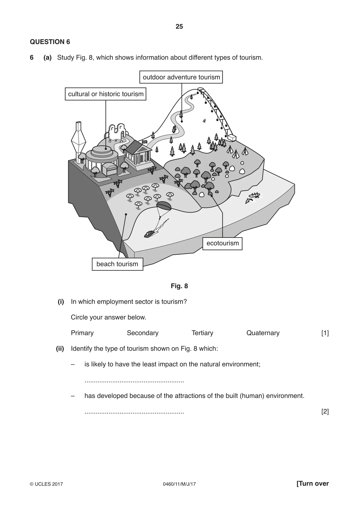
25 0460/11/M/J/17 © UCLES 2017 [Turn over QUESTION 6 6 (a) Study Fig. 8, which shows information about different types of tourism. cultural or historic tourism outdoor adventure tourism beach tourism ecotourism Fig. 8 (i) In which employment sector is tourism? Circle your answer below. Primary Secondary Tertiary Quaternary [1] (ii) Identify the type of tourism shown on Fig. 8 which: – is likely to have the least impact on the natural environment; … – has developed because of the attractions of the built (human) environment. … [2]
Question paper, page 26
26 0460/11/M/J/17 © UCLES 2017 (iii) Choose one type of tourism shown on Fig. 8 and explain how it might cause problems for local people. Type of tourism chosen … … … … … … … [3] (iv) Choose two different types of landscape and explain why they attract tourists. 1 … … … … 2 … … … … [4]
Question paper, page 27
27 0460/11/M/J/17 © UCLES 2017 [Turn over (b) Study Photograph D (Insert), which was taken in Mumbai, India (an LEDC). (i) Using Photograph D, suggest three ways in which tourism can create employment for people in Mumbai. 1 … … 2 … … 3 … … [3] (ii) Explain how the tourist industry shown in Photograph D might cause problems for the local natural environment. … … … … … … … … … … [5]
Question paper, page 28
28 0460/11/M/J/17 © UCLES 2017 (c) For a named area you have studied where tourism is important, explain how it is being managed in order for it to be sustainable. Name of area … … … … … … … … … … … … … … … … … … … … … … [7] [Total: 25 marks] END OF QUESTION 6
Question paper, page 29
29 0460/11/M/J/17 © UCLES 2017 Additional Pages If you use the following lined pages to complete the answer(s) to any question(s), the question number(s) must be clearly shown. … … … … … … … … … … … … … … … … … … … … … … … … … …
Question paper, page 30
30 0460/11/M/J/17 © UCLES 2017 … … … … … … … … … … … … … … … … … … … … … … … … … … … …
Question paper, page 31
31 0460/11/M/J/17 © UCLES 2017 BLANK PAGE
Question paper, page 32
32 0460/11/M/J/17 © UCLES 2017 BLANK PAGE Permission to reproduce items where third-party owned material protected by copyright is included has been sought and cleared where possible. Every reasonable effort has been made by the publisher (UCLES) to trace copyright holders, but if any items requiring clearance have unwittingly been included, the publisher will be pleased to make amends at the earliest possible opportunity. To avoid the issue of disclosure of answer-related information to candidates, all copyright acknowledgements are reproduced online in the Cambridge International Examinations Copyright Acknowledgements Booklet. This is produced for each series of examinations and is freely available to download at www.cie.org.uk after the live examination series. Cambridge International Examinations is part of the Cambridge Assessment Group. Cambridge Assessment is the brand name of University of Cambridge Local Examinations Syndicate (UCLES), which is itself a department of the University of Cambridge.
Mark scheme, page 1
® IGCSE is a registered trademark. This syllabus is approved for use in England, Wales and Northern Ireland as a Cambridge International Level 1/Level 2 Certificate. This document consists of 16 printed pages. © UCLES 2017 [Turn over Cambridge International Examinations Cambridge International General Certificate of Secondary Education GEOGRAPHY 0460/11 Paper 1 May/June 2017 MARK SCHEME Maximum Mark: 75 Published This mark scheme is published as an aid to teachers and candidates, to indicate the requirements of the examination. It shows the basis on which Examiners were instructed to award marks. It does not indicate the details of the discussions that took place at an Examiners’ meeting before marking began, which would have considered the acceptability of alternative answers. Mark schemes should be read in conjunction with the question paper and the Principal Examiner Report for Teachers. Cambridge will not enter into discussions about these mark schemes. Cambridge is publishing the mark schemes for the May/June 2017 series for most Cambridge IGCSE®, Cambridge International A and AS Level and Cambridge Pre-U components, and some Cambridge O Level components.
Mark scheme, page 2
0460/11 Cambridge IGCSE – Mark Scheme PUBLISHED May/June 2017 © UCLES 2017 Page 2 of 16 Levels of response marking is used for section (c) of each question. Thus it is the quality of the response that determines which level an answer is achieved rather than the quantity of statements contained within it. However, once assigned to a level the mark achieved within that level is determined by the number of points made. Levels 1 and 2 are distinguished by whether statements are simple (level 1) or developed/elaborated (level 2). A candidate can immediately enter L2 by making developed points without making any L1 statements. In order to achieve L3 a candidate must have already reached the top end of L2 – in addition his/her answer should have a clear example and if the answer is place specific as well (7 marks). Highlight place specific detail. Where statements are assigned levels by the examiner this should be indicated by the use of L1 and L2 next to the statements. Ticks should not be used on answers that are marked using levels of response marking. L1 annotation should be removed once a L2 is awarded for an answer. L3 annotation is not used. There is no need for a summary level at the end of a response. Summary: Level 1 (1 to 3 marks): 1 simple statement (1 mark) 2 simple statements (2 marks) 3 simple statements (3 marks) Level 2 (4 to 6 marks): 1 developed statement (4 marks) 2 developed statements (5 marks) 3 or more developed statements with eg (6 marks) Level 3 (7 marks) 3 or more developed statements + named example with at least one piece of place specific detail.
Mark scheme, page 3
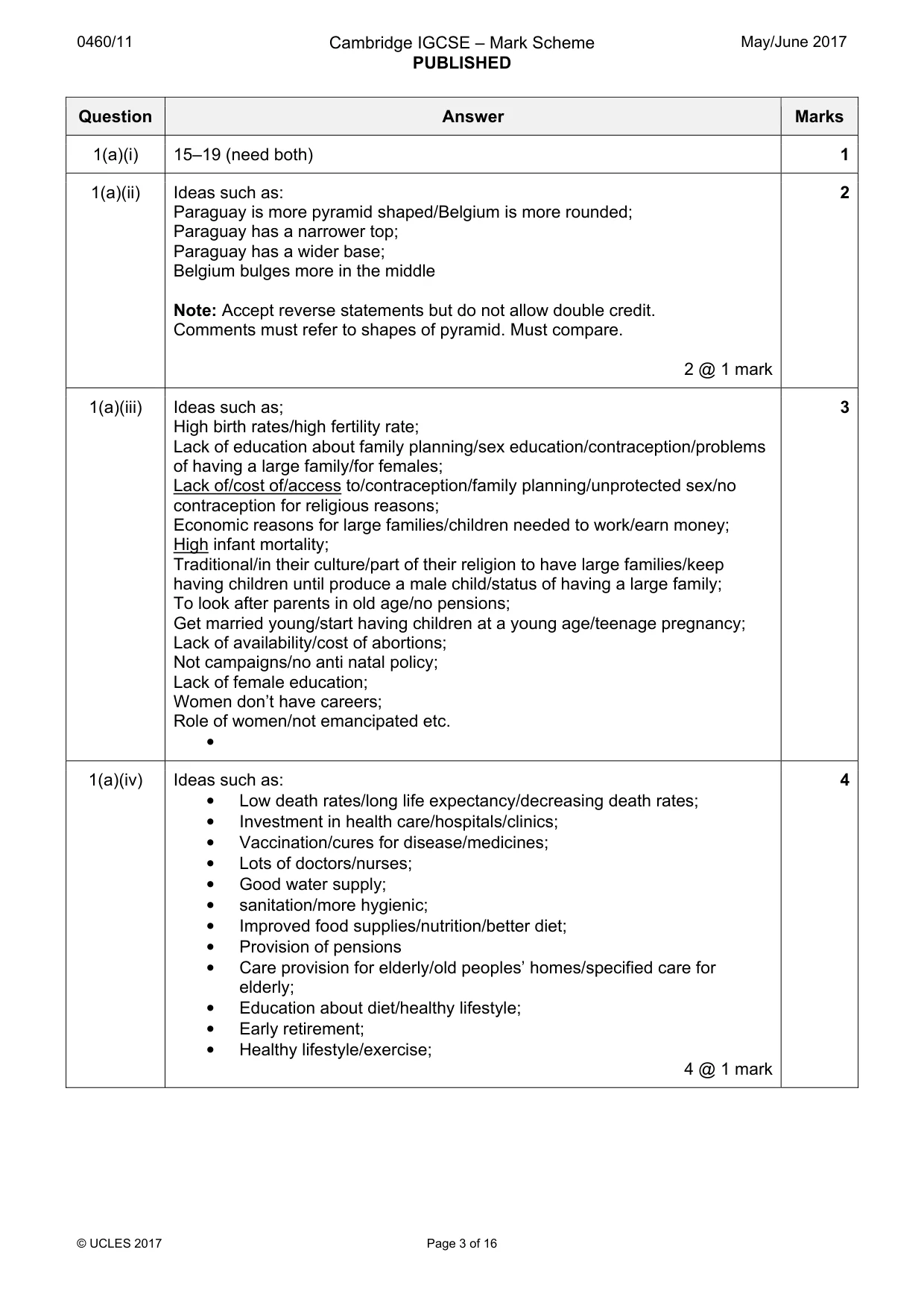
0460/11 Cambridge IGCSE – Mark Scheme PUBLISHED May/June 2017 © UCLES 2017 Page 3 of 16 Question Answer Marks 1(a)(i) 15–19 (need both) 1 1(a)(ii) Ideas such as: Paraguay is more pyramid shaped/Belgium is more rounded; Paraguay has a narrower top; Paraguay has a wider base; Belgium bulges more in the middle Note: Accept reverse statements but do not allow double credit. Comments must refer to shapes of pyramid. Must compare. 2 @ 1 mark 2 1(a)(iii) Ideas such as; High birth rates/high fertility rate; Lack of education about family planning/sex education/contraception/problems of having a large family/for females; Lack of/cost of/access to/contraception/family planning/unprotected sex/no contraception for religious reasons; Economic reasons for large families/children needed to work/earn money; High infant mortality; Traditional/in their culture/part of their religion to have large families/keep having children until produce a male child/status of having a large family; To look after parents in old age/no pensions; Get married young/start having children at a young age/teenage pregnancy; Lack of availability/cost of abortions; Not campaigns/no anti natal policy; Lack of female education; Women don’t have careers; Role of women/not emancipated etc. • 3 1(a)(iv) Ideas such as: • Low death rates/long life expectancy/decreasing death rates; • Investment in health care/hospitals/clinics; • Vaccination/cures for disease/medicines; • Lots of doctors/nurses; • Good water supply; • sanitation/more hygienic; • Improved food supplies/nutrition/better diet; • Provision of pensions • Care provision for elderly/old peoples’ homes/specified care for elderly; • Education about diet/healthy lifestyle; • Early retirement; • Healthy lifestyle/exercise; 4 @ 1 mark 4
Mark scheme, page 4
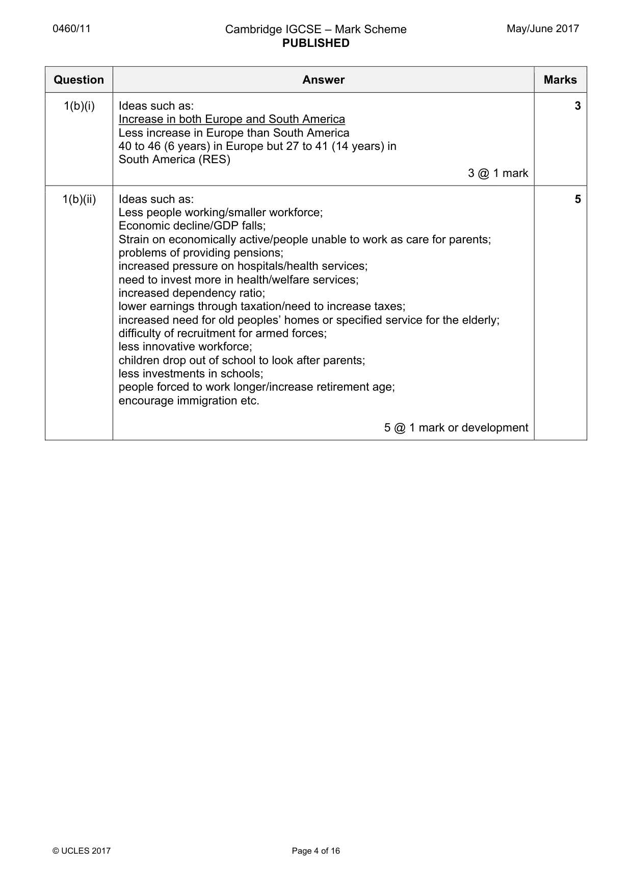
0460/11 Cambridge IGCSE – Mark Scheme PUBLISHED May/June 2017 © UCLES 2017 Page 4 of 16 Question Answer Marks 1(b)(i) Ideas such as: Increase in both Europe and South America Less increase in Europe than South America 40 to 46 (6 years) in Europe but 27 to 41 (14 years) in South America (RES) 3 @ 1 mark 3 1(b)(ii) Ideas such as: Less people working/smaller workforce; Economic decline/GDP falls; Strain on economically active/people unable to work as care for parents; problems of providing pensions; increased pressure on hospitals/health services; need to invest more in health/welfare services; increased dependency ratio; lower earnings through taxation/need to increase taxes; increased need for old peoples’ homes or specified service for the elderly; difficulty of recruitment for armed forces; less innovative workforce; children drop out of school to look after parents; less investments in schools; people forced to work longer/increase retirement age; encourage immigration etc. 5 @ 1 mark or development 5
Mark scheme, page 5
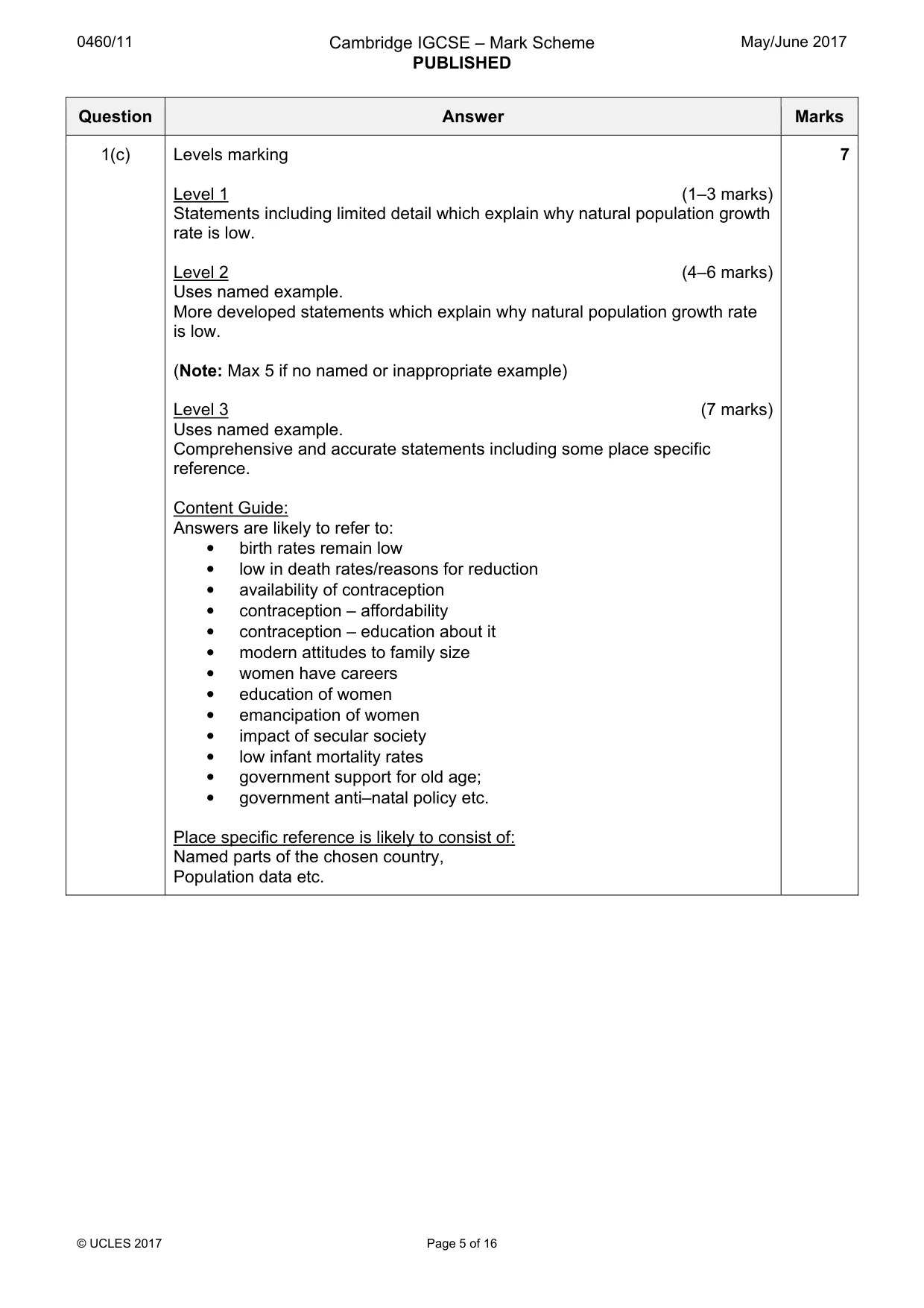
0460/11 Cambridge IGCSE – Mark Scheme PUBLISHED May/June 2017 © UCLES 2017 Page 5 of 16 Question Answer Marks 1(c) Levels marking Level 1 (1–3 marks) Statements including limited detail which explain why natural population growth rate is low. Level 2 (4–6 marks) Uses named example. More developed statements which explain why natural population growth rate is low. (Note: Max 5 if no named or inappropriate example) Level 3 (7 marks) Uses named example. Comprehensive and accurate statements including some place specific reference. Content Guide: Answers are likely to refer to: • birth rates remain low • low in death rates/reasons for reduction • availability of contraception • contraception – affordability • contraception – education about it • modern attitudes to family size • women have careers • education of women • emancipation of women • impact of secular society • low infant mortality rates • government support for old age; • government anti–natal policy etc. Place specific reference is likely to consist of: Named parts of the chosen country, Population data etc. 7
Mark scheme, page 6
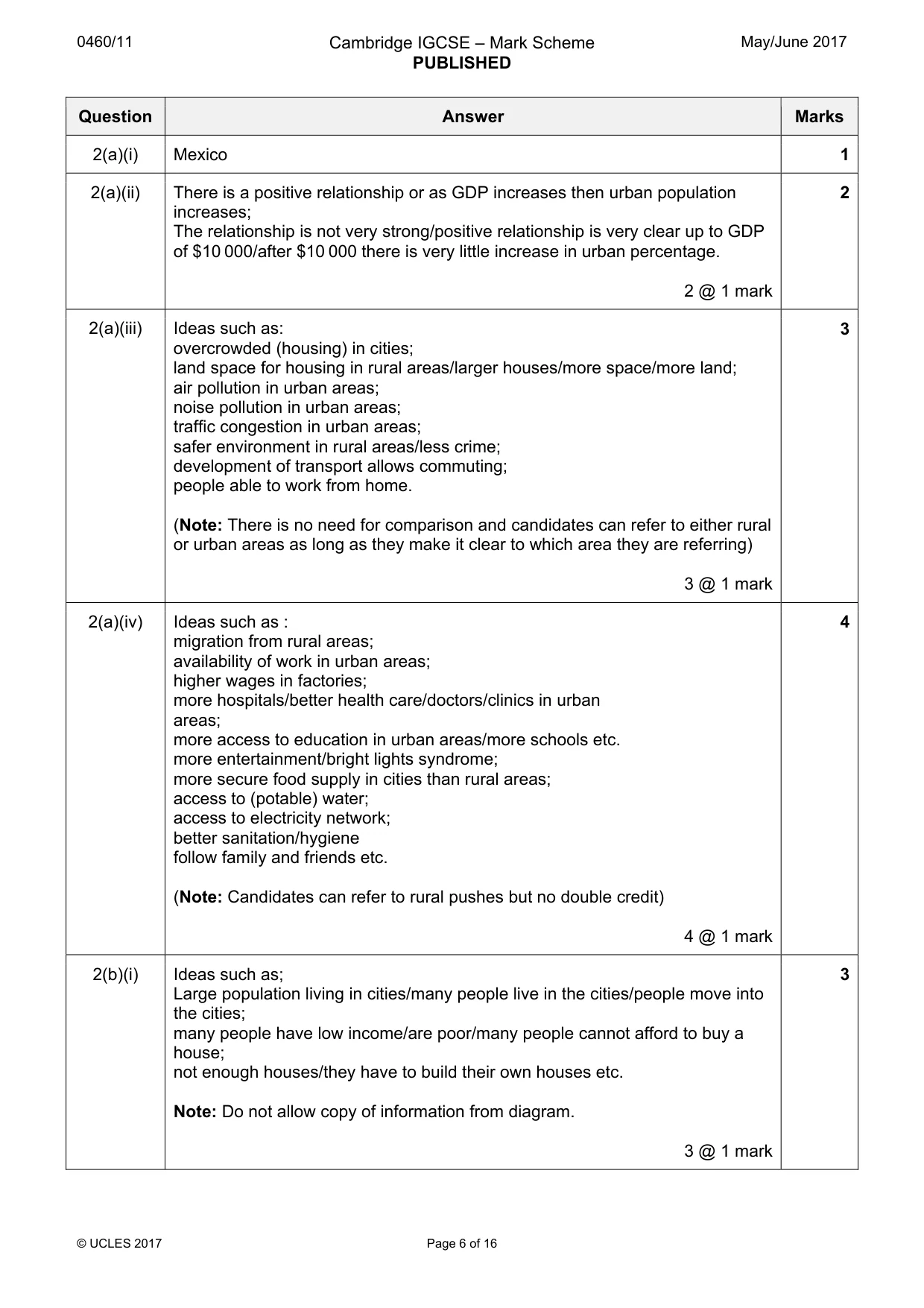
0460/11 Cambridge IGCSE – Mark Scheme PUBLISHED May/June 2017 © UCLES 2017 Page 6 of 16 Question Answer Marks 2(a)(i) Mexico 1 2(a)(ii) There is a positive relationship or as GDP increases then urban population increases; The relationship is not very strong/positive relationship is very clear up to GDP of $10 000/after $10 000 there is very little increase in urban percentage. 2 @ 1 mark 2 2(a)(iii) Ideas such as: overcrowded (housing) in cities; land space for housing in rural areas/larger houses/more space/more land; air pollution in urban areas; noise pollution in urban areas; traffic congestion in urban areas; safer environment in rural areas/less crime; development of transport allows commuting; people able to work from home. (Note: There is no need for comparison and candidates can refer to either rural or urban areas as long as they make it clear to which area they are referring) 3 @ 1 mark 3 2(a)(iv) Ideas such as : migration from rural areas; availability of work in urban areas; higher wages in factories; more hospitals/better health care/doctors/clinics in urban areas; more access to education in urban areas/more schools etc. more entertainment/bright lights syndrome; more secure food supply in cities than rural areas; access to (potable) water; access to electricity network; better sanitation/hygiene follow family and friends etc. (Note: Candidates can refer to rural pushes but no double credit) 4 @ 1 mark 4 2(b)(i) Ideas such as; Large population living in cities/many people live in the cities/people move into the cities; many people have low income/are poor/many people cannot afford to buy a house; not enough houses/they have to build their own houses etc. Note: Do not allow copy of information from diagram. 3 @ 1 mark 3
Mark scheme, page 7
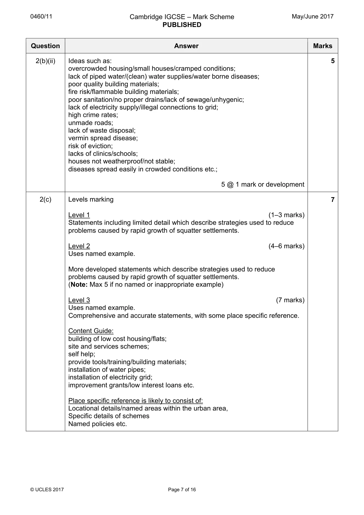
0460/11 Cambridge IGCSE – Mark Scheme PUBLISHED May/June 2017 © UCLES 2017 Page 7 of 16 Question Answer Marks 2(b)(ii) Ideas such as: overcrowded housing/small houses/cramped conditions; lack of piped water/(clean) water supplies/water borne diseases; poor quality building materials; fire risk/flammable building materials; poor sanitation/no proper drains/lack of sewage/unhygenic; lack of electricity supply/illegal connections to grid; high crime rates; unmade roads; lack of waste disposal; vermin spread disease; risk of eviction; lacks of clinics/schools; houses not weatherproof/not stable; diseases spread easily in crowded conditions etc.; 5 @ 1 mark or development 5 2(c) Levels marking Level 1 (1–3 marks) Statements including limited detail which describe strategies used to reduce problems caused by rapid growth of squatter settlements. Level 2 (4–6 marks) Uses named example. More developed statements which describe strategies used to reduce problems caused by rapid growth of squatter settlements. (Note: Max 5 if no named or inappropriate example) Level 3 (7 marks) Uses named example. Comprehensive and accurate statements, with some place specific reference. Content Guide: building of low cost housing/flats; site and services schemes; self help; provide tools/training/building materials; installation of water pipes; installation of electricity grid; improvement grants/low interest loans etc. Place specific reference is likely to consist of: Locational details/named areas within the urban area, Specific details of schemes Named policies etc. 7
Mark scheme, page 8
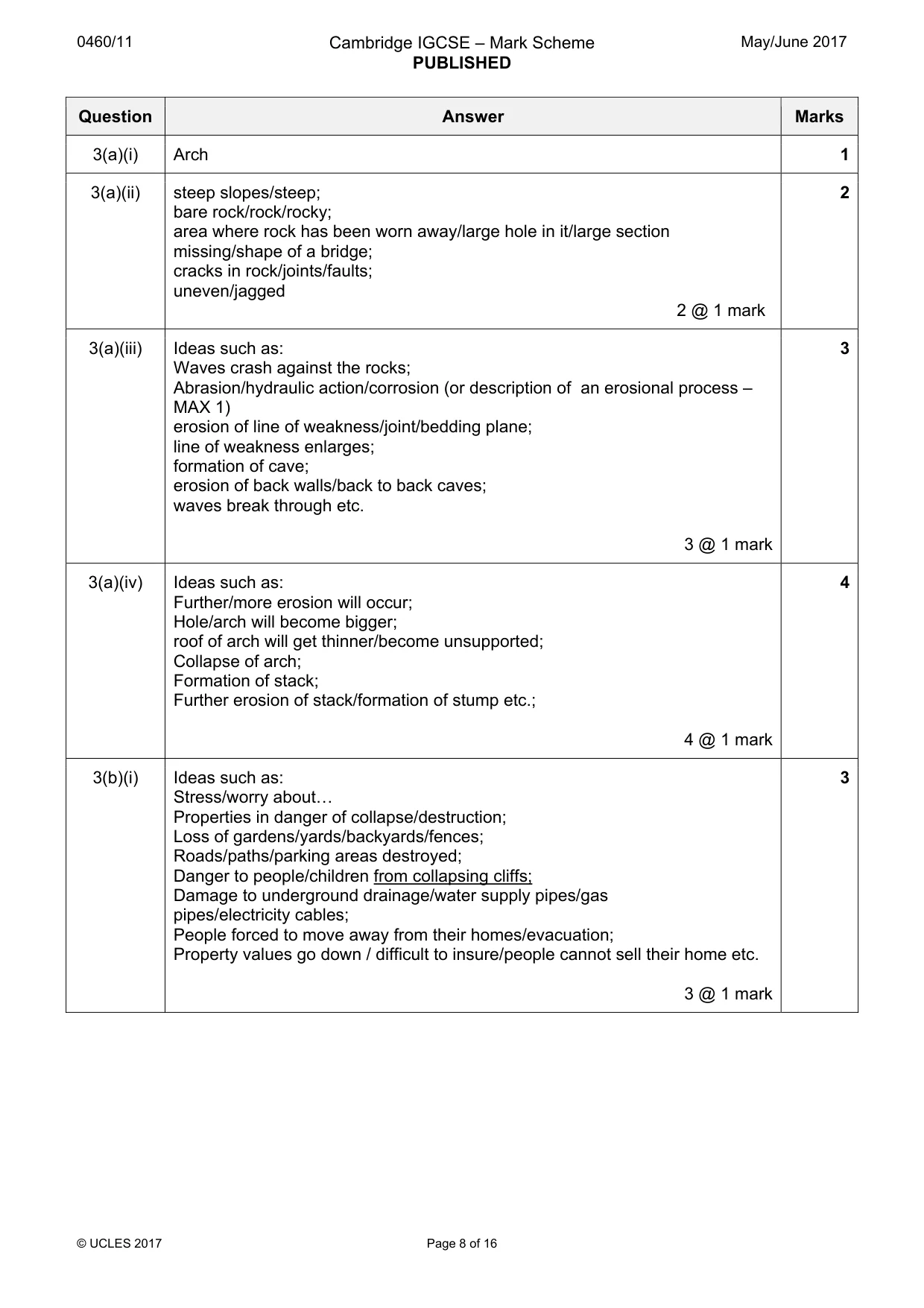
0460/11 Cambridge IGCSE – Mark Scheme PUBLISHED May/June 2017 © UCLES 2017 Page 8 of 16 Question Answer Marks 3(a)(i) Arch 1 3(a)(ii) steep slopes/steep; bare rock/rock/rocky; area where rock has been worn away/large hole in it/large section missing/shape of a bridge; cracks in rock/joints/faults; uneven/jagged 2 @ 1 mark 2 3(a)(iii) Ideas such as: Waves crash against the rocks; Abrasion/hydraulic action/corrosion (or description of an erosional process – MAX 1) erosion of line of weakness/joint/bedding plane; line of weakness enlarges; formation of cave; erosion of back walls/back to back caves; waves break through etc. 3 @ 1 mark 3 3(a)(iv) Ideas such as: Further/more erosion will occur; Hole/arch will become bigger; roof of arch will get thinner/become unsupported; Collapse of arch; Formation of stack; Further erosion of stack/formation of stump etc.; 4 @ 1 mark 4 3(b)(i) Ideas such as: Stress/worry about« Properties in danger of collapse/destruction; Loss of gardens/yards/backyards/fences; Roads/paths/parking areas destroyed; Danger to people/children from collapsing cliffs; Damage to underground drainage/water supply pipes/gas pipes/electricity cables; People forced to move away from their homes/evacuation; Property values go down / difficult to insure/people cannot sell their home etc. 3 @ 1 mark 3
Mark scheme, page 9
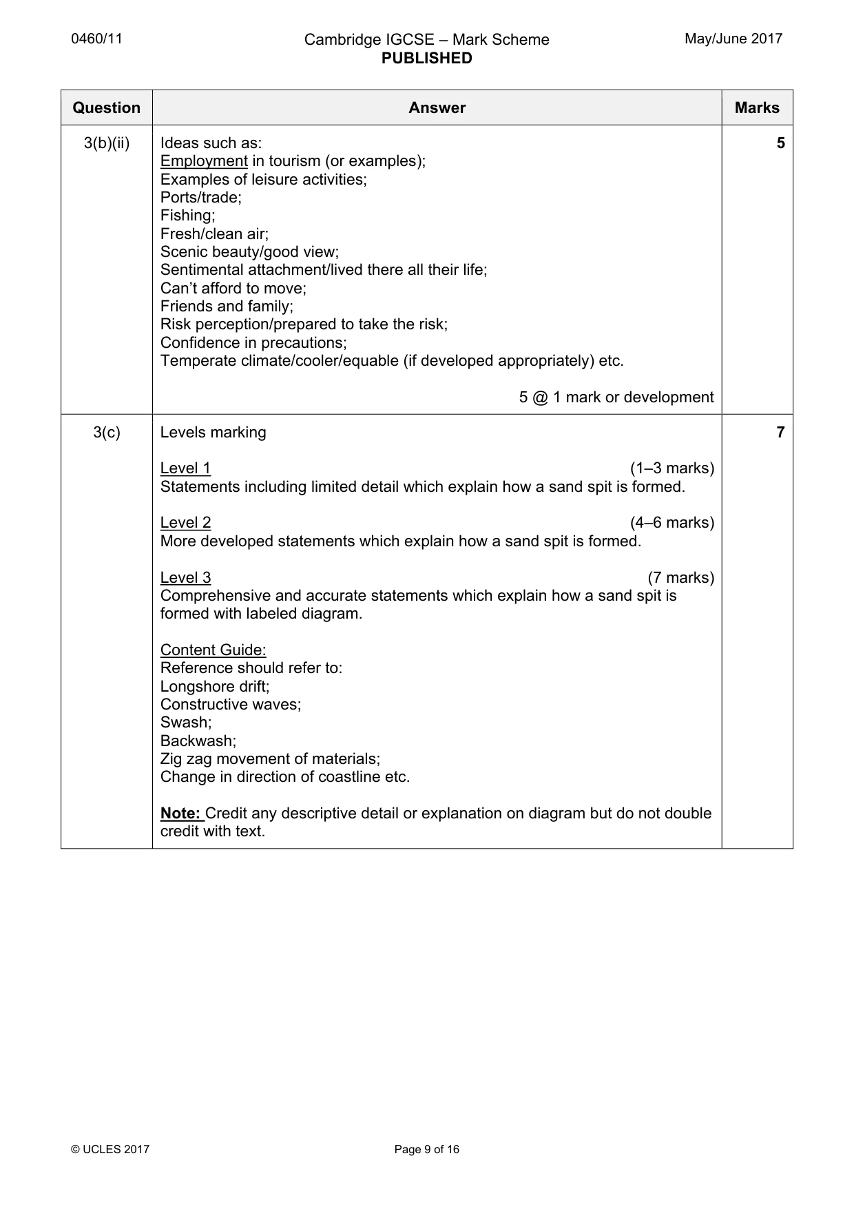
0460/11 Cambridge IGCSE – Mark Scheme PUBLISHED May/June 2017 © UCLES 2017 Page 9 of 16 Question Answer Marks 3(b)(ii) Ideas such as: Employment in tourism (or examples); Examples of leisure activities; Ports/trade; Fishing; Fresh/clean air; Scenic beauty/good view; Sentimental attachment/lived there all their life; Can’t afford to move; Friends and family; Risk perception/prepared to take the risk; Confidence in precautions; Temperate climate/cooler/equable (if developed appropriately) etc. 5 @ 1 mark or development 5 3(c) Levels marking Level 1 (1–3 marks) Statements including limited detail which explain how a sand spit is formed. Level 2 (4–6 marks) More developed statements which explain how a sand spit is formed. Level 3 (7 marks) Comprehensive and accurate statements which explain how a sand spit is formed with labeled diagram. Content Guide: Reference should refer to: Longshore drift; Constructive waves; Swash; Backwash; Zig zag movement of materials; Change in direction of coastline etc. Note: Credit any descriptive detail or explanation on diagram but do not double credit with text. 7
Mark scheme, page 10
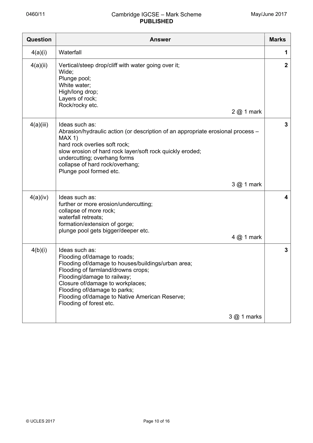
0460/11 Cambridge IGCSE – Mark Scheme PUBLISHED May/June 2017 © UCLES 2017 Page 10 of 16 Question Answer Marks 4(a)(i) Waterfall 1 4(a)(ii) Vertical/steep drop/cliff with water going over it; Wide; Plunge pool; White water; High/long drop; Layers of rock; Rock/rocky etc. 2 @ 1 mark 2 4(a)(iii) Ideas such as: Abrasion/hydraulic action (or description of an appropriate erosional process – MAX 1) hard rock overlies soft rock; slow erosion of hard rock layer/soft rock quickly eroded; undercutting; overhang forms collapse of hard rock/overhang; Plunge pool formed etc. 3 @ 1 mark 3 4(a)(iv) Ideas such as: further or more erosion/undercutting; collapse of more rock; waterfall retreats; formation/extension of gorge; plunge pool gets bigger/deeper etc. 4 @ 1 mark 4 4(b)(i) Ideas such as: Flooding of/damage to roads; Flooding of/damage to houses/buildings/urban area; Flooding of farmland/drowns crops; Flooding/damage to railway; Closure of/damage to workplaces; Flooding of/damage to parks; Flooding of/damage to Native American Reserve; Flooding of forest etc. 3 @ 1 marks 3
Mark scheme, page 11
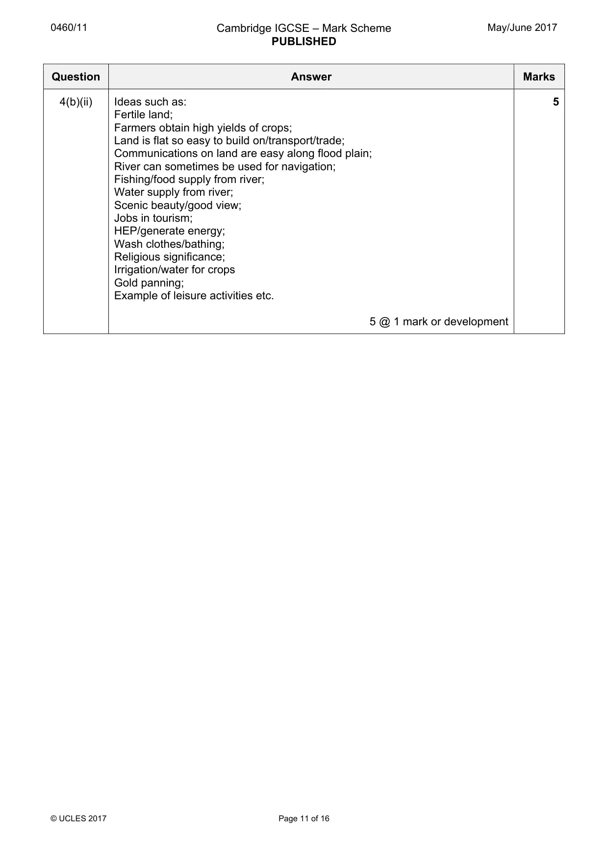
0460/11 Cambridge IGCSE – Mark Scheme PUBLISHED May/June 2017 © UCLES 2017 Page 11 of 16 Question Answer Marks 4(b)(ii) Ideas such as: Fertile land; Farmers obtain high yields of crops; Land is flat so easy to build on/transport/trade; Communications on land are easy along flood plain; River can sometimes be used for navigation; Fishing/food supply from river; Water supply from river; Scenic beauty/good view; Jobs in tourism; HEP/generate energy; Wash clothes/bathing; Religious significance; Irrigation/water for crops Gold panning; Example of leisure activities etc. 5 @ 1 mark or development 5
Mark scheme, page 12
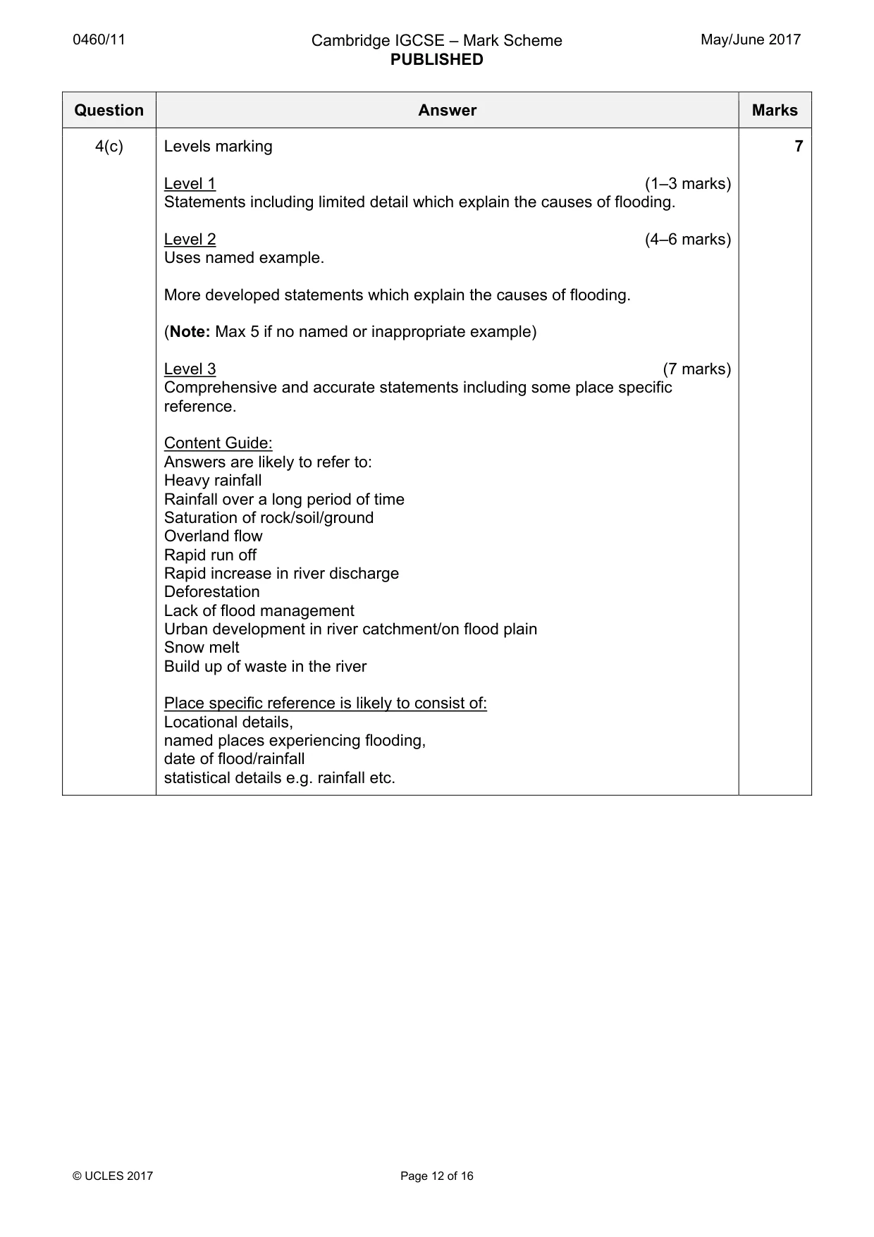
0460/11 Cambridge IGCSE – Mark Scheme PUBLISHED May/June 2017 © UCLES 2017 Page 12 of 16 Question Answer Marks 4(c) Levels marking Level 1 (1–3 marks) Statements including limited detail which explain the causes of flooding. Level 2 (4–6 marks) Uses named example. More developed statements which explain the causes of flooding. (Note: Max 5 if no named or inappropriate example) Level 3 (7 marks) Comprehensive and accurate statements including some place specific reference. Content Guide: Answers are likely to refer to: Heavy rainfall Rainfall over a long period of time Saturation of rock/soil/ground Overland flow Rapid run off Rapid increase in river discharge Deforestation Lack of flood management Urban development in river catchment/on flood plain Snow melt Build up of waste in the river Place specific reference is likely to consist of: Locational details, named places experiencing flooding, date of flood/rainfall statistical details e.g. rainfall etc. 7
Mark scheme, page 13
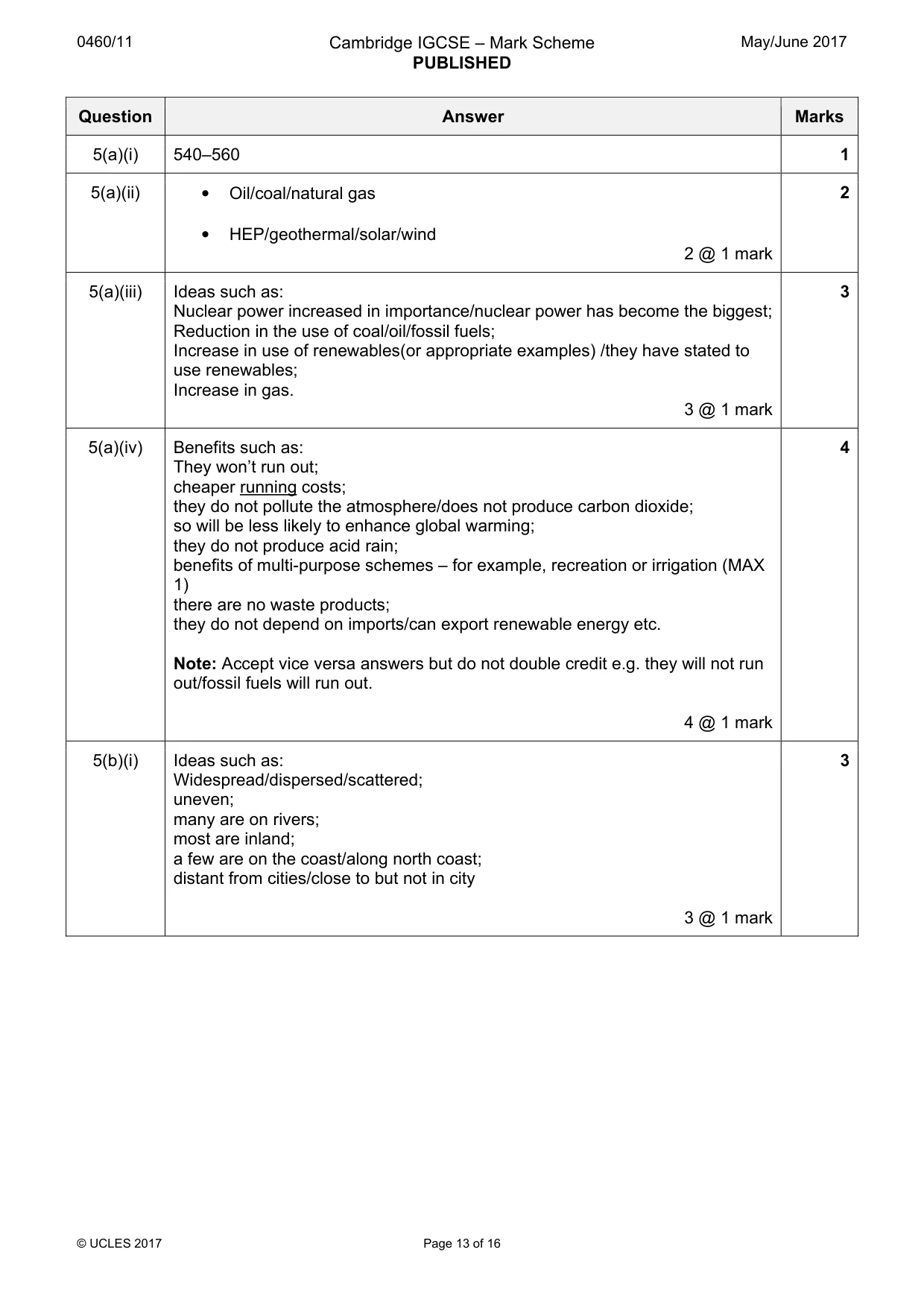
0460/11 Cambridge IGCSE – Mark Scheme PUBLISHED May/June 2017 © UCLES 2017 Page 13 of 16 Question Answer Marks 5(a)(i) 540–560 1 5(a)(ii) • Oil/coal/natural gas • HEP/geothermal/solar/wind 2 @ 1 mark 2 5(a)(iii) Ideas such as: Nuclear power increased in importance/nuclear power has become the biggest; Reduction in the use of coal/oil/fossil fuels; Increase in use of renewables(or appropriate examples) /they have stated to use renewables; Increase in gas. 3 @ 1 mark 3 5(a)(iv) Benefits such as: They won’t run out; cheaper running costs; they do not pollute the atmosphere/does not produce carbon dioxide; so will be less likely to enhance global warming; they do not produce acid rain; benefits of multi-purpose schemes – for example, recreation or irrigation (MAX 1) there are no waste products; they do not depend on imports/can export renewable energy etc. Note: Accept vice versa answers but do not double credit e.g. they will not run out/fossil fuels will run out. 4 @ 1 mark 4 5(b)(i) Ideas such as: Widespread/dispersed/scattered; uneven; many are on rivers; most are inland; a few are on the coast/along north coast; distant from cities/close to but not in city 3 @ 1 mark 3
Mark scheme, page 14
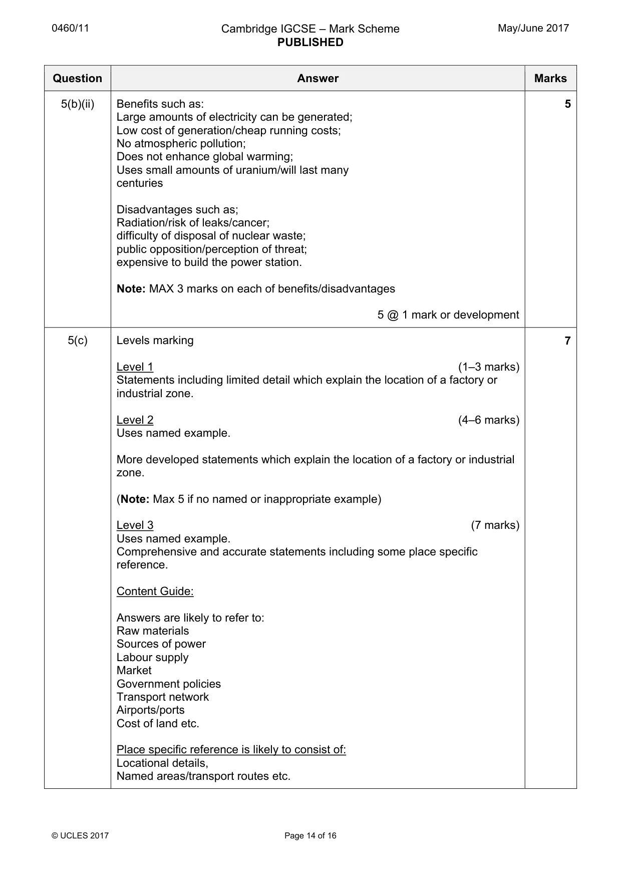
0460/11 Cambridge IGCSE – Mark Scheme PUBLISHED May/June 2017 © UCLES 2017 Page 14 of 16 Question Answer Marks 5(b)(ii) Benefits such as: Large amounts of electricity can be generated; Low cost of generation/cheap running costs; No atmospheric pollution; Does not enhance global warming; Uses small amounts of uranium/will last many centuries Disadvantages such as; Radiation/risk of leaks/cancer; difficulty of disposal of nuclear waste; public opposition/perception of threat; expensive to build the power station. Note: MAX 3 marks on each of benefits/disadvantages 5 @ 1 mark or development 5 5(c) Levels marking Level 1 (1–3 marks) Statements including limited detail which explain the location of a factory or industrial zone. Level 2 (4–6 marks) Uses named example. More developed statements which explain the location of a factory or industrial zone. (Note: Max 5 if no named or inappropriate example) Level 3 (7 marks) Uses named example. Comprehensive and accurate statements including some place specific reference. Content Guide: Answers are likely to refer to: Raw materials Sources of power Labour supply Market Government policies Transport network Airports/ports Cost of land etc. Place specific reference is likely to consist of: Locational details, Named areas/transport routes etc. 7
Mark scheme, page 15
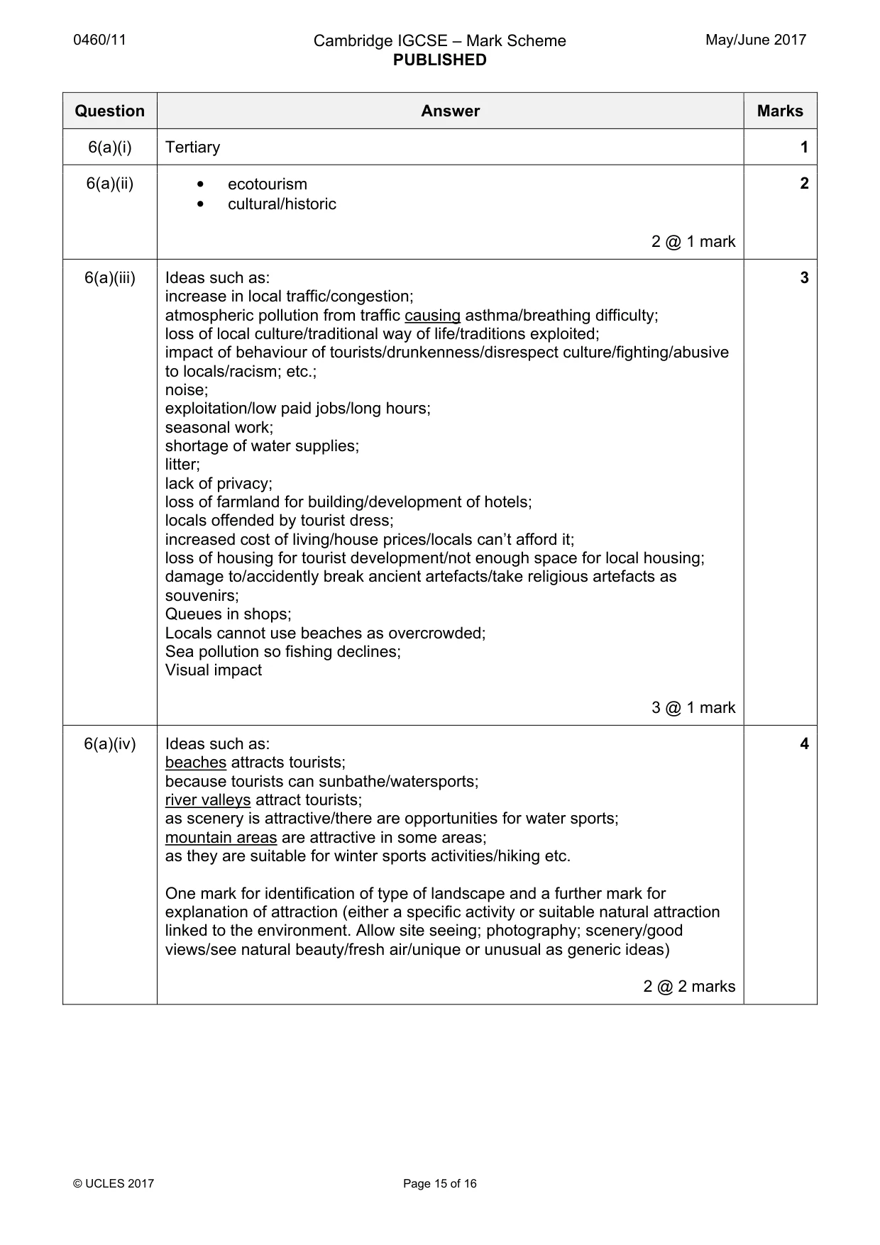
0460/11 Cambridge IGCSE – Mark Scheme PUBLISHED May/June 2017 © UCLES 2017 Page 15 of 16 Question Answer Marks 6(a)(i) Tertiary 1 6(a)(ii) • ecotourism • cultural/historic 2 @ 1 mark 2 6(a)(iii) Ideas such as: increase in local traffic/congestion; atmospheric pollution from traffic causing asthma/breathing difficulty; loss of local culture/traditional way of life/traditions exploited; impact of behaviour of tourists/drunkenness/disrespect culture/fighting/abusive to locals/racism; etc.; noise; exploitation/low paid jobs/long hours; seasonal work; shortage of water supplies; litter; lack of privacy; loss of farmland for building/development of hotels; locals offended by tourist dress; increased cost of living/house prices/locals can’t afford it; loss of housing for tourist development/not enough space for local housing; damage to/accidently break ancient artefacts/take religious artefacts as souvenirs; Queues in shops; Locals cannot use beaches as overcrowded; Sea pollution so fishing declines; Visual impact 3 @ 1 mark 3 6(a)(iv) Ideas such as: beaches attracts tourists; because tourists can sunbathe/watersports; river valleys attract tourists; as scenery is attractive/there are opportunities for water sports; mountain areas are attractive in some areas; as they are suitable for winter sports activities/hiking etc. One mark for identification of type of landscape and a further mark for explanation of attraction (either a specific activity or suitable natural attraction linked to the environment. Allow site seeing; photography; scenery/good views/see natural beauty/fresh air/unique or unusual as generic ideas) 2 @ 2 marks 4
Mark scheme, page 16
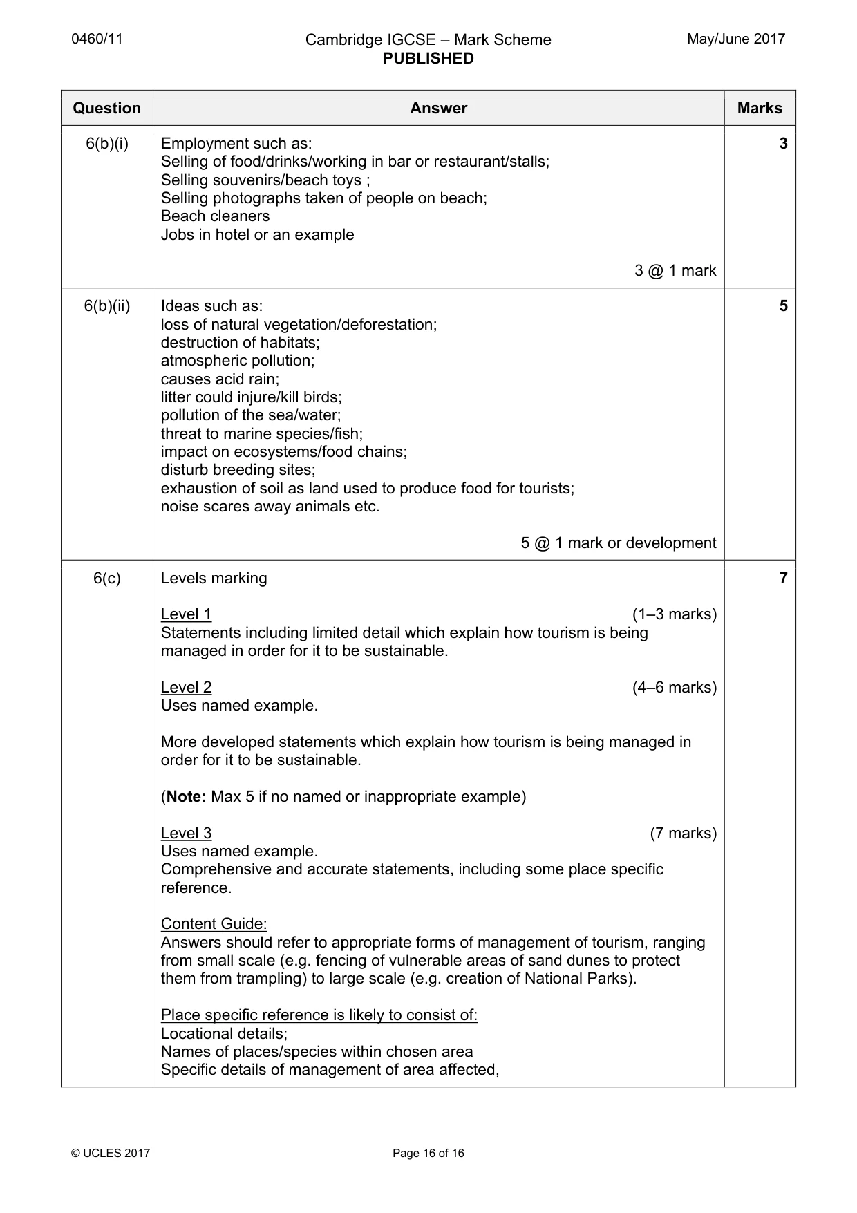
0460/11 Cambridge IGCSE – Mark Scheme PUBLISHED May/June 2017 © UCLES 2017 Page 16 of 16 Question Answer Marks 6(b)(i) Employment such as: Selling of food/drinks/working in bar or restaurant/stalls; Selling souvenirs/beach toys ; Selling photographs taken of people on beach; Beach cleaners Jobs in hotel or an example 3 @ 1 mark 3 6(b)(ii) Ideas such as: loss of natural vegetation/deforestation; destruction of habitats; atmospheric pollution; causes acid rain; litter could injure/kill birds; pollution of the sea/water; threat to marine species/fish; impact on ecosystems/food chains; disturb breeding sites; exhaustion of soil as land used to produce food for tourists; noise scares away animals etc. 5 @ 1 mark or development 5 6(c) Levels marking Level 1 (1–3 marks) Statements including limited detail which explain how tourism is being managed in order for it to be sustainable. Level 2 (4–6 marks) Uses named example. More developed statements which explain how tourism is being managed in order for it to be sustainable. (Note: Max 5 if no named or inappropriate example) Level 3 (7 marks) Uses named example. Comprehensive and accurate statements, including some place specific reference. Content Guide: Answers should refer to appropriate forms of management of tourism, ranging from small scale (e.g. fencing of vulnerable areas of sand dunes to protect them from trampling) to large scale (e.g. creation of National Parks). Place specific reference is likely to consist of: Locational details; Names of places/species within chosen area Specific details of management of area affected, 7
What you needed in this session
Cambridge’s own grade thresholds for 2017 May/June, Paper 1 · Variant 1. A higher threshold means an easier paper — the bar moves with how the cohort did.