Cambridge IGCSE Geography 0460 — 2017 May/June Paper 1 · Variant 3
0460/13/M/J/17 · 75 marks · ≈84 min
The question paper and its mark scheme, free to read here and free to download. This is Cambridge’s own paper, exactly as it was sat.
Question paper28 pages

Mark scheme17 pages
Answers below. Sit the paper first if you are practising.
Paper as text
Question paper, page 1
This document consists of 28 printed pages and 1 Insert. DC (ST/JG) 130427/5 © UCLES 2017 [Turn over Cambridge International Examinations Cambridge International General Certificate of Secondary Education * 0 1 4 2 2 7 4 8 2 6 * GEOGRAPHY 0460/13 Paper 1 May/June 2017 1 hour 45 minutes Candidates answer on the Question Paper. Additional Materials: Calculator Ruler READ THESE INSTRUCTIONS FIRST Write your Centre number, candidate number and name in the spaces provided. Write in dark blue or black pen. You may use an HB pencil for any diagrams or graphs. Do not use staples, paper clips, glue or correction fluid. DO NOT WRITE IN ANY BARCODES. Write your answer to each question in the space provided. If additional space is required, you should use the lined pages at the end of this booklet. The question number(s) must be clearly shown. Answer three questions, one from each section. The Insert contains Photographs A, B, C and D for Question 2 and Photographs E, F and G for Question 4. The Insert is not required by the Examiner. Sketch maps and diagrams should be drawn whenever they serve to illustrate an answer. At the end of the examination, fasten all your work securely together. The number of marks is given in brackets [ ] at the end of each question or part question. Definitions: MEDCs – More Economically Developed Countries LEDCs – Less Economically Developed Countries The syllabus is approved for use in England, Wales and Northern Ireland as a Cambridge International Level 1/Level 2 Certificate.
Question paper, page 2
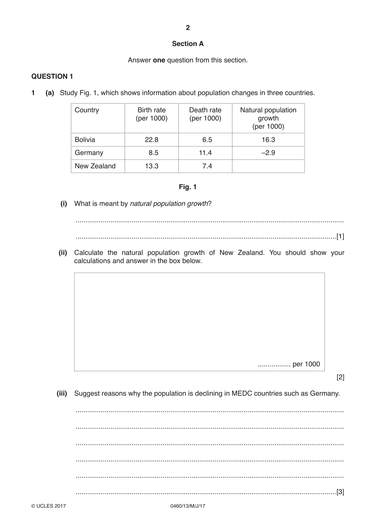
2 0460/13/M/J/17 © UCLES 2017 Section A Answer one question from this section. QUESTION 1 1 (a) Study Fig. 1, which shows information about population changes in three countries. Country Birth rate (per 1000) Death rate (per 1000) Natural population growth (per 1000) Bolivia 22.8 6.5 16.3 Germany 8.5 11.4 –2.9 New Zealand 13.3 7.4 Fig. 1 (i) What is meant by natural population growth? … …[1] (ii) Calculate the natural population growth of New Zealand. You should show your calculations and answer in the box below. … per 1000 [2] (iii) Suggest reasons why the population is declining in MEDC countries such as Germany. … … … … … …[3]
Question paper, page 3
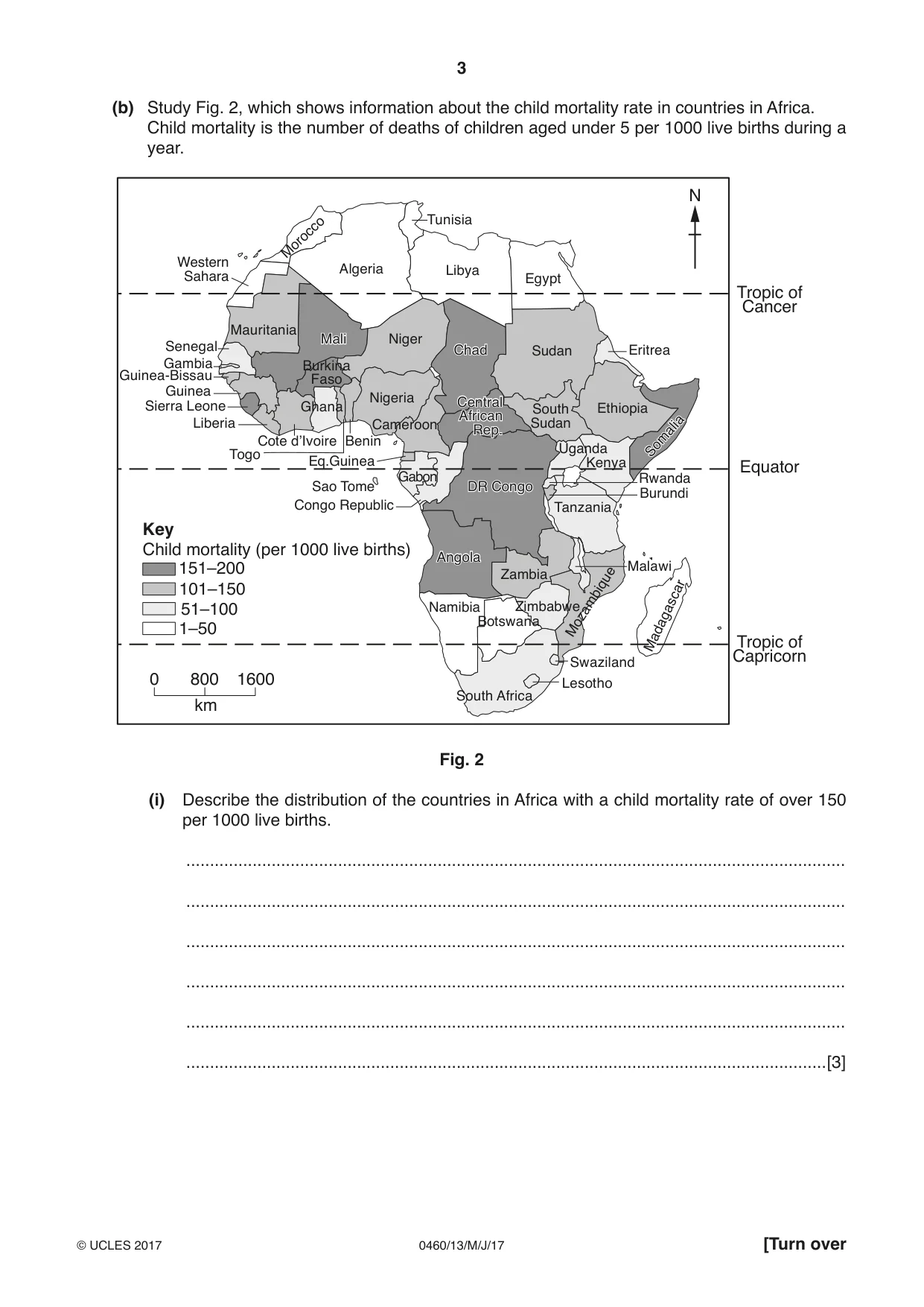
3 0460/13/M/J/17 © UCLES 2017 [Turn over (b) Study Fig. 2, which shows information about the child mortality rate in countries in Africa. Child mortality is the number of deaths of children aged under 5 per 1000 live births during a year. 0 800 1600 km Child mortality (per 1000 live births) 1–50 51–100 101–150 151–200 N Key Zimbabwe Zambia Tunisia Togo Tanzania Swaziland Sudan South Sudan South Africa Somalia DR Congo Chad Central African Rep. Angola Somalia Sierra Leone Senegal Rwanda Nigeria Niger Namibia Mozambique Morocco Western Sahara Mauritania Mali Mali Malawi Madagascar Libya Liberia Lesotho Kenya Uganda Guinea-Bissau Guinea Ghana Gambia Gabon Ethiopia Eritrea Eq.Guinea Egypt Cote d’Ivoire Congo Republic Sao Tome DR Congo Chad Central African Rep. Cameroon Burundi Burkina Faso Botswana Benin Angola Algeria Tropic of Cancer Tropic of Capricorn Equator Fig. 2 (i) Describe the distribution of the countries in Africa with a child mortality rate of over 150 per 1000 live births. … … … … … …[3]
Question paper, page 4
4 0460/13/M/J/17 © UCLES 2017 (ii) Suggest reasons why child mortality is high in some countries in Africa. … … … … … … … …[4] (iii) Explain why countries with high child mortality are likely to have high birth rates. … … … … … … … … … …[5]
Question paper, page 5
5 0460/13/M/J/17 © UCLES 2017 [Turn over (c) For a named country you have studied, describe a population policy which has been used to influence its population growth rate. Name of country … … … … … … … … … … … … … … … … … … … … … … … … …[7] [Total: 25 marks] END OF QUESTION 1
Question paper, page 6
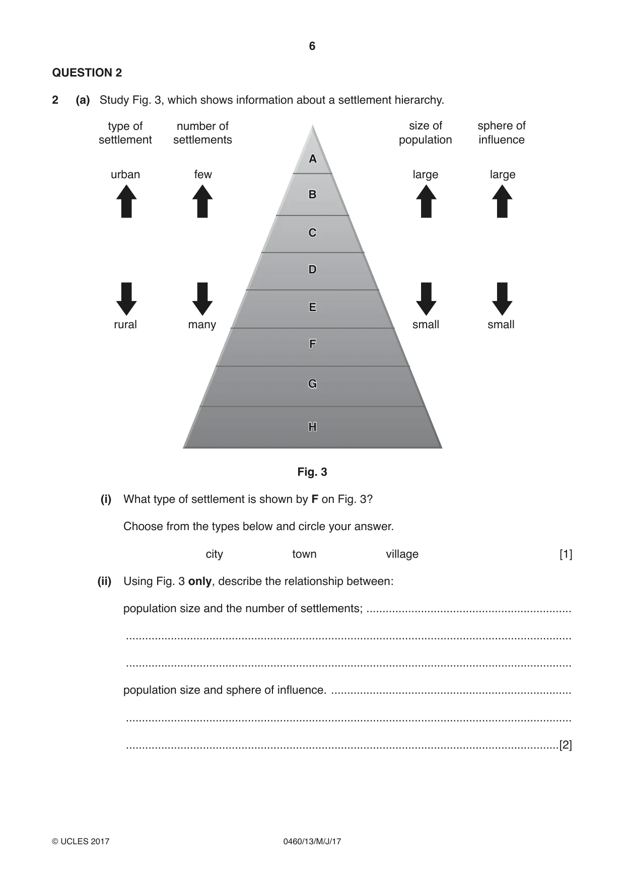
6 0460/13/M/J/17 © UCLES 2017 QUESTION 2 2 (a) Study Fig. 3, which shows information about a settlement hierarchy. A B C D E F G H A B C D E F G H number of settlements type of settlement few many small small large large urban rural size of population sphere of influence Fig. 3 (i) What type of settlement is shown by F on Fig. 3? Choose from the types below and circle your answer. city town village [1] (ii) Using Fig. 3 only, describe the relationship between: population size and the number of settlements; … … … population size and sphere of influence. … … …[2]
Question paper, page 7
7 0460/13/M/J/17 © UCLES 2017 [Turn over (iii) Give three reasons why some settlements grow into large urban areas but others remain small. 1 … … 2 … … 3 … …[3] (b) Study Photographs A, B, C and D (Insert), which show different types of services in settlements. (i) Which of Photographs A, B, C or D shows: a transportation service; Photograph … a service providing entertainment; Photograph … a service providing health care; Photograph … a service selling comparison goods? Photograph … [3] (ii) Explain why low order services are found in most settlements. … … … … … … … …[4]
Question paper, page 8
8 0460/13/M/J/17 © UCLES 2017 (iii) Explain why shops selling comparison goods are usually located in middle and high order settlements. … … … … … … … … … …[5]
Question paper, page 9
9 0460/13/M/J/17 © UCLES 2017 [Turn over (c) For an urban area you have studied, state one problem which occurs and explain its causes. You should choose from the following problems: Housing issues Traffic congestion Air pollution Name of urban area … Problem … … … … … … … … … … … … … … … … … … … … …[7] [Total: 25 marks] END OF QUESTION 2
Question paper, page 10
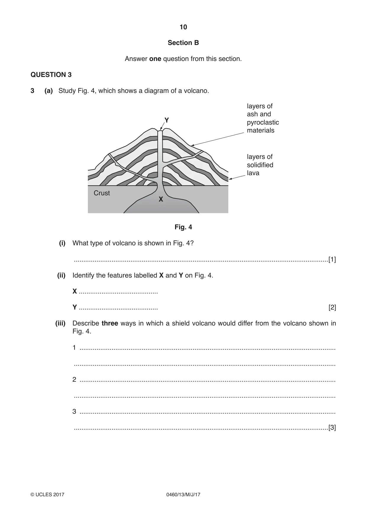
10 0460/13/M/J/17 © UCLES 2017 Section B Answer one question from this section. QUESTION 3 3 (a) Study Fig. 4, which shows a diagram of a volcano. X Y layers of solidified lava layers of ash and pyroclastic materials Crust Fig. 4 (i) What type of volcano is shown in Fig. 4? …[1] (ii) Identify the features labelled X and Y on Fig. 4. X … Y … [2] (iii) Describe three ways in which a shield volcano would differ from the volcano shown in Fig. 4. 1 … … 2 … … 3 … …[3]
Question paper, page 11
11 0460/13/M/J/17 © UCLES 2017 [Turn over (iv) Describe the global distribution of volcanoes. … … … … … … … …[4]
Question paper, page 12
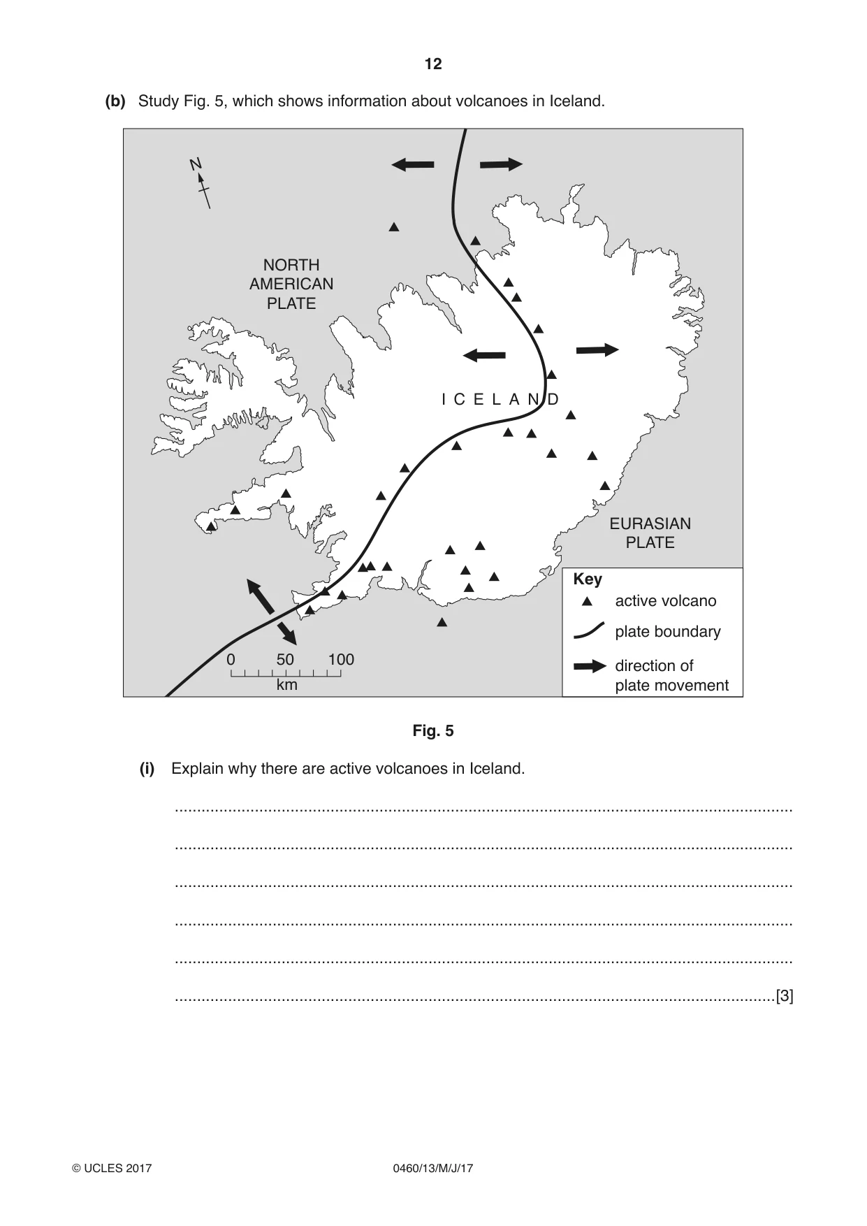
12 0460/13/M/J/17 © UCLES 2017 (b) Study Fig. 5, which shows information about volcanoes in Iceland. N 0 50 100 km NORTH AMERICAN PLATE EURASIAN PLATE active volcano plate boundary direction of plate movement I C E L A N D Key Fig. 5 (i) Explain why there are active volcanoes in Iceland. … … … … … …[3]
Question paper, page 13
13 0460/13/M/J/17 © UCLES 2017 [Turn over (ii) Explain why people live in areas where there are active volcanoes. … … … … … … … … … …[5]
Question paper, page 14
14 0460/13/M/J/17 © UCLES 2017 (c) Earthquakes are another natural hazard. Describe the impacts of an earthquake in a named area you have studied. Name of area … … … … … … … … … … … … … … … … … … … … … … … … …[7] [Total: 25 marks] END OF QUESTION 3
Question paper, page 15
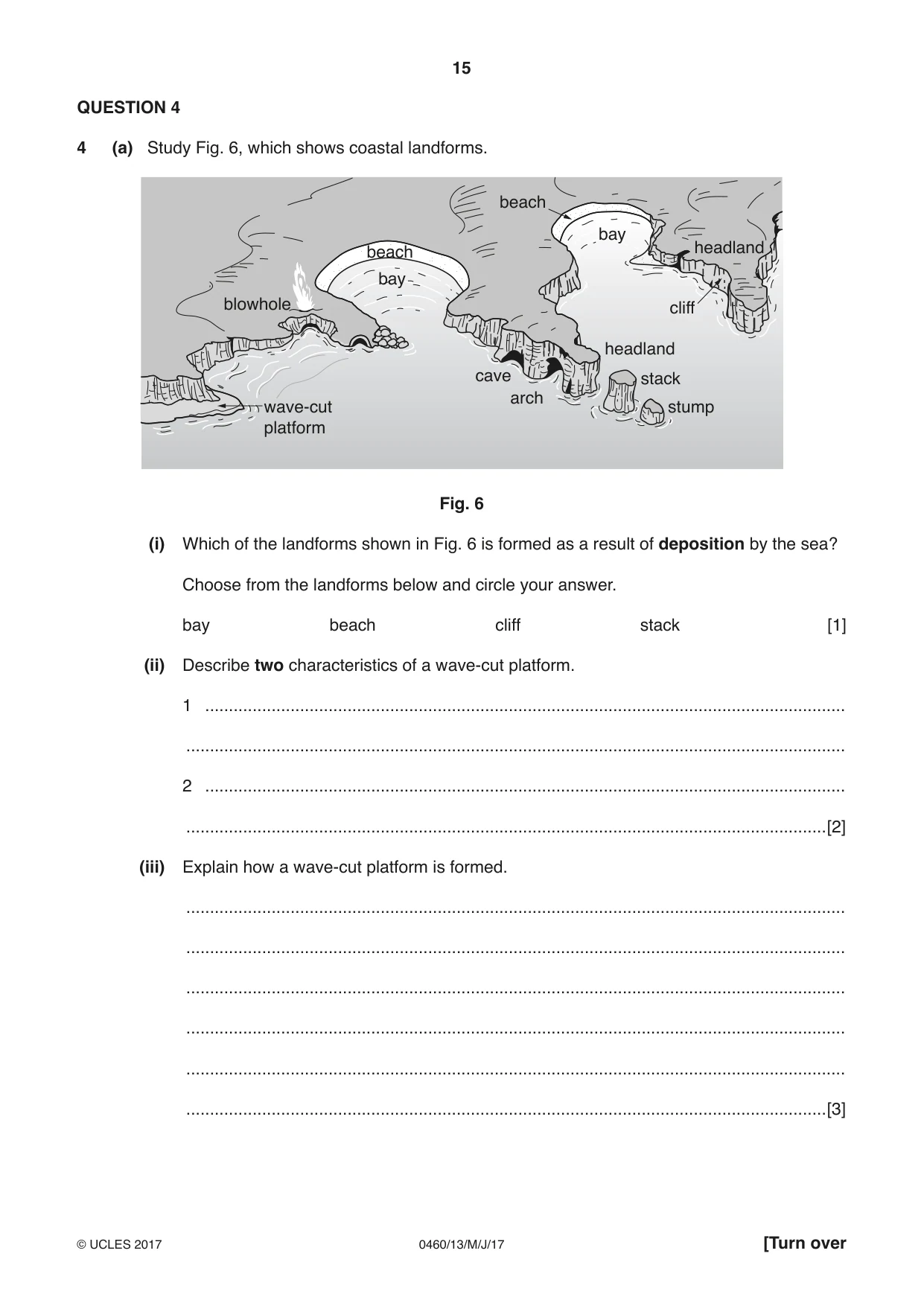
15 0460/13/M/J/17 © UCLES 2017 [Turn over QUESTION 4 4 (a) Study Fig. 6, which shows coastal landforms. bay headland headland blowhole beach beach stack cliff stump arch cave bay wave-cut platform Fig. 6 (i) Which of the landforms shown in Fig. 6 is formed as a result of deposition by the sea? Choose from the landforms below and circle your answer. bay beach cliff stack [1] (ii) Describe two characteristics of a wave-cut platform. 1 … … 2 … …[2] (iii) Explain how a wave-cut platform is formed. … … … … … …[3]
Question paper, page 16
16 0460/13/M/J/17 © UCLES 2017 (iv) Suggest reasons why bays and headlands have formed along the coast shown in Fig. 6. … … … … … … … …[4] (b) Study Photographs E, F and G (Insert). (i) Using Photographs E, F and G only, describe three different opportunities which these coastal areas provide for people. Photograph E … … Photograph F … … Photograph G … …[3] (ii) Explain why living on or close to a coast can be hazardous. … … … … … … … … … …[5]
Question paper, page 17
17 0460/13/M/J/17 © UCLES 2017 [Turn over (c) For an area you have studied, describe how coastal hazards are being managed. Name of area … … … … … … … … … … … … … … … … … … … … … … … … …[7] [Total: 25 marks] END OF QUESTION 4
Question paper, page 18
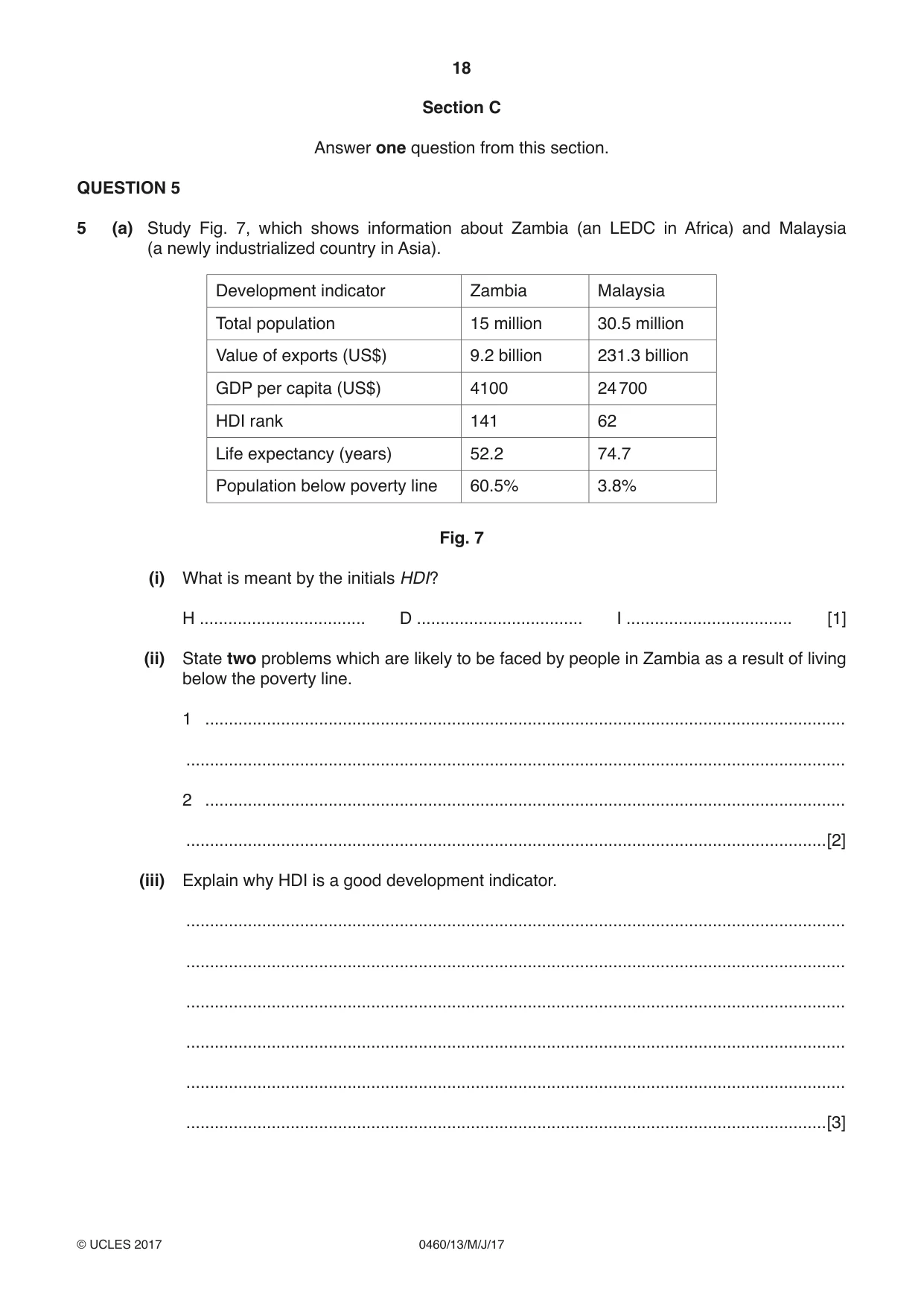
18 0460/13/M/J/17 © UCLES 2017 Section C Answer one question from this section. QUESTION 5 5 (a) Study Fig. 7, which shows information about Zambia (an LEDC in Africa) and Malaysia (a newly industrialized country in Asia). Development indicator Zambia Malaysia Total population 15 million 30.5 million Value of exports (US$) 9.2 billion 231.3 billion GDP per capita (US$) 4100 24 700 HDI rank 141 62 Life expectancy (years) 52.2 74.7 Population below poverty line 60.5% 3.8% Fig. 7 (i) What is meant by the initials HDI? H … D … I … [1] (ii) State two problems which are likely to be faced by people in Zambia as a result of living below the poverty line. 1 … … 2 … …[2] (iii) Explain why HDI is a good development indicator. … … … … … …[3]
Question paper, page 19
19 0460/13/M/J/17 © UCLES 2017 [Turn over (iv) Suggest reasons to explain the inequalities between Zambia and Malaysia shown on Fig. 7. … … … … … … … …[4]
Question paper, page 20
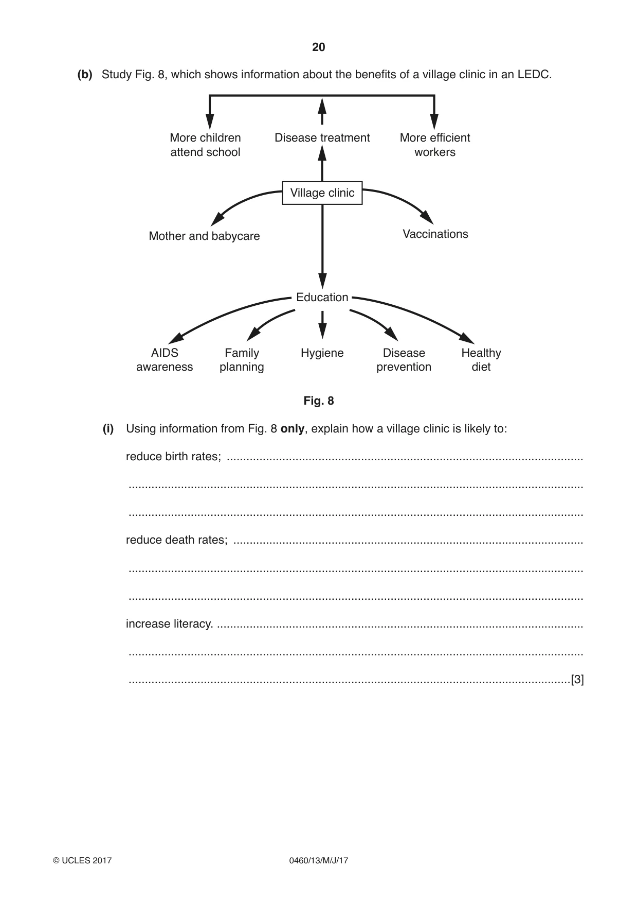
20 0460/13/M/J/17 © UCLES 2017 (b) Study Fig. 8, which shows information about the benefits of a village clinic in an LEDC. Disease treatment Mother and babycare Vaccinations More children attend school More efficient workers Village clinic Education Hygiene Disease prevention Healthy diet Family planning AIDS awareness Fig. 8 (i) Using information from Fig. 8 only, explain how a village clinic is likely to: reduce birth rates; … … … reduce death rates; … … … increase literacy. … … …[3]
Question paper, page 21
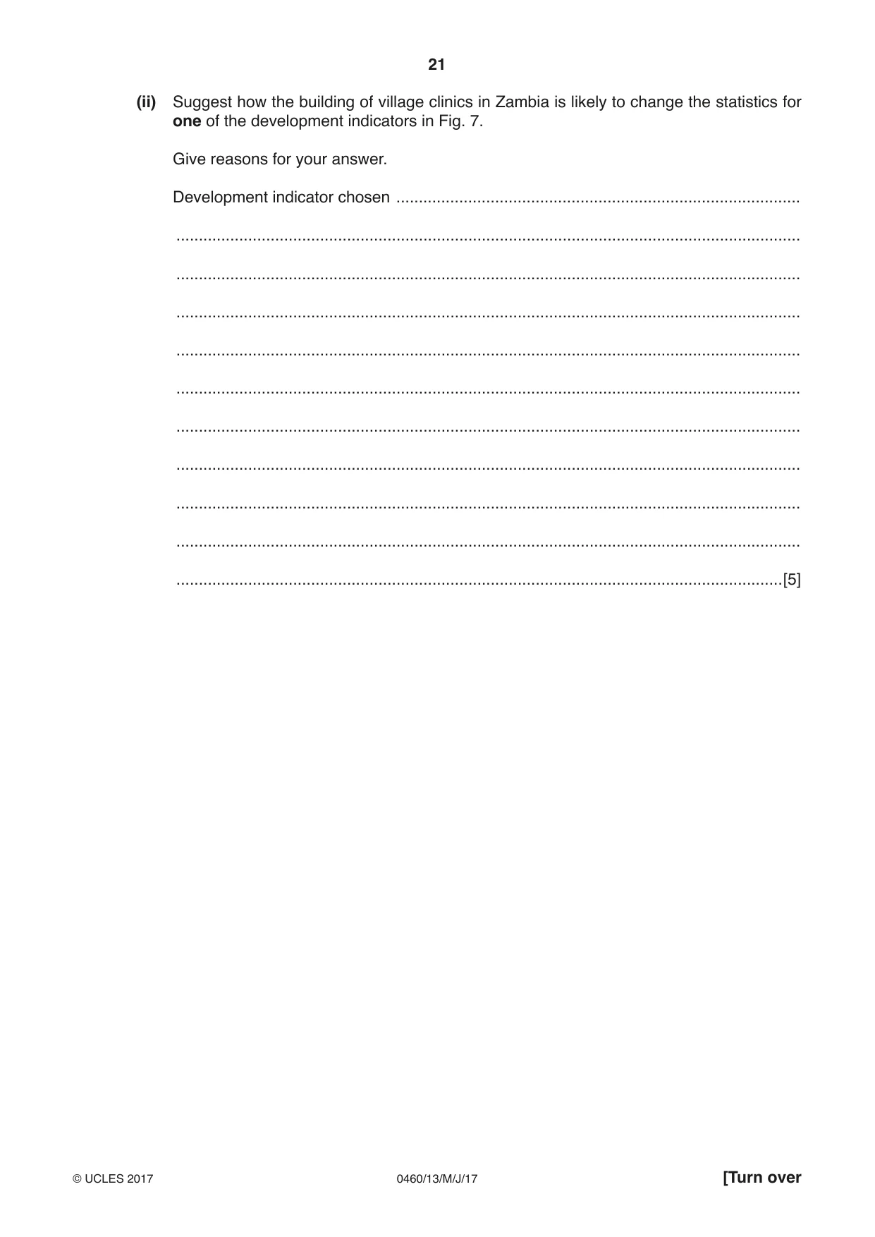
21 0460/13/M/J/17 © UCLES 2017 [Turn over (ii) Suggest how the building of village clinics in Zambia is likely to change the statistics for one of the development indicators in Fig. 7. Give reasons for your answer. Development indicator chosen … … … … … … … … … … …[5]
Question paper, page 22
22 0460/13/M/J/17 © UCLES 2017 (c) Describe the impacts of a named transnational corporation (TNC) on a country where its goods are produced or services provided. Name of transnational corporation (TNC) … Name of country … … … … … … … … … … … … … … … … … … … … … … … … …[7] [Total: 25 marks] END OF QUESTION 5
Question paper, page 23
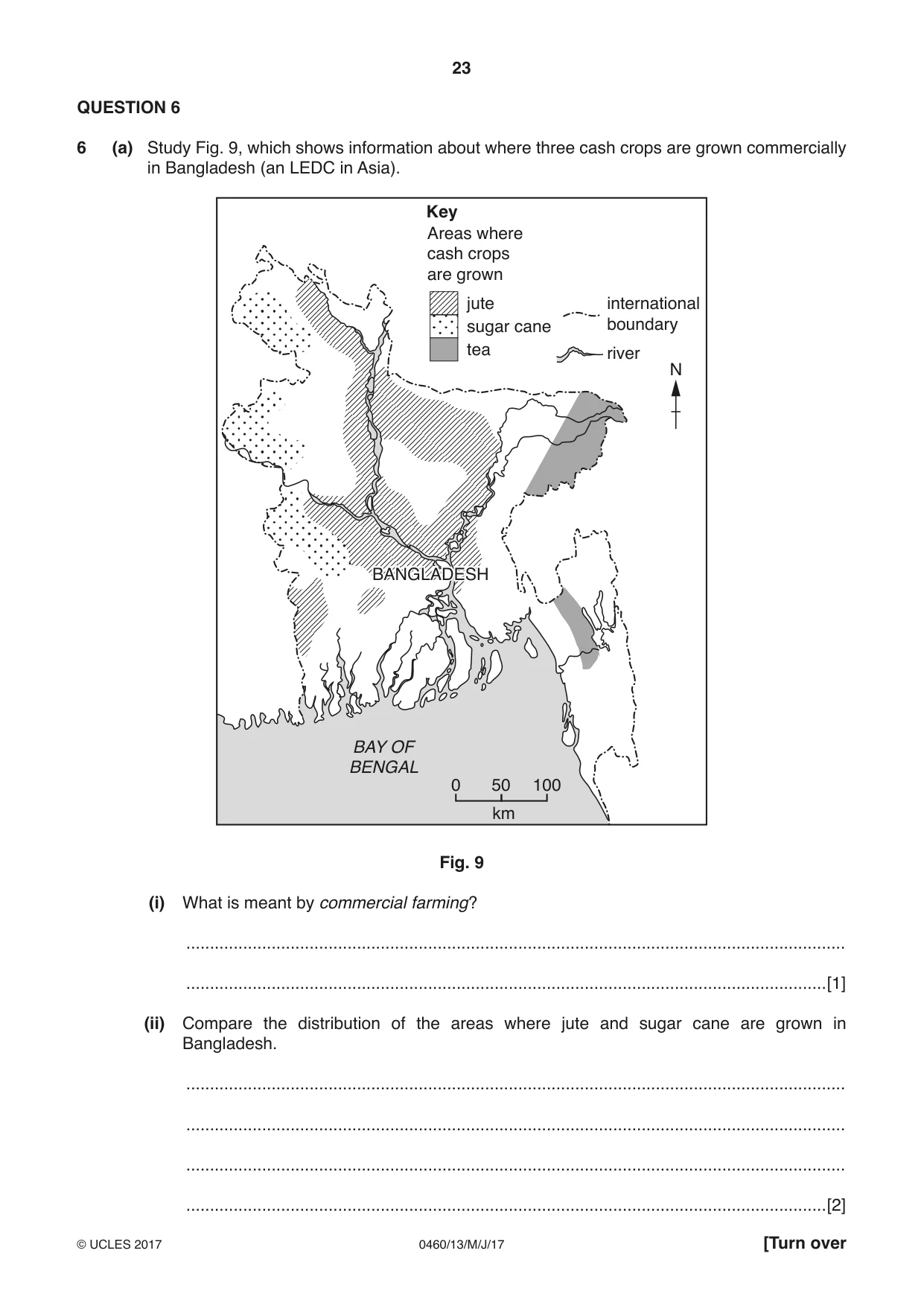
23 0460/13/M/J/17 © UCLES 2017 [Turn over QUESTION 6 6 (a) Study Fig. 9, which shows information about where three cash crops are grown commercially in Bangladesh (an LEDC in Asia). 0 50 100 BAY OF BENGAL BANGLADESH km Key tea international boundary river sugar cane jute N Areas where cash crops are grown Fig. 9 (i) What is meant by commercial farming? … …[1] (ii) Compare the distribution of the areas where jute and sugar cane are grown in Bangladesh. … … … …[2]
Question paper, page 24
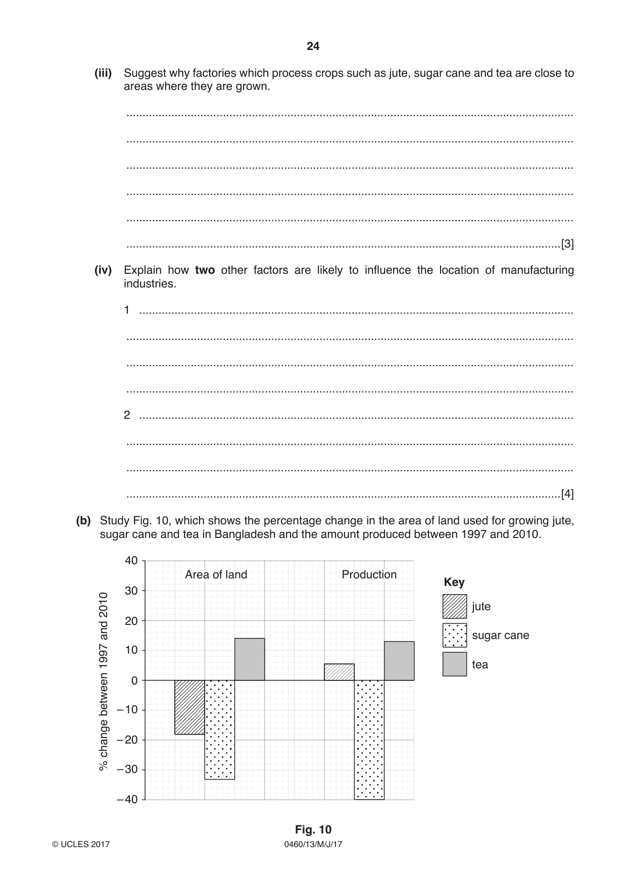
24 0460/13/M/J/17 © UCLES 2017 (iii) Suggest why factories which process crops such as jute, sugar cane and tea are close to areas where they are grown. … … … … … …[3] (iv) Explain how two other factors are likely to influence the location of manufacturing industries. 1 … … … … 2 … … … …[4] (b) Study Fig. 10, which shows the percentage change in the area of land used for growing jute, sugar cane and tea in Bangladesh and the amount produced between 1997 and 2010. Key Area of land Production tea sugar cane jute 0 – 10 10 20 30 40 – 20 – 30 – 40 % change between 1997 and 2010 Fig. 10
Question paper, page 25
25 0460/13/M/J/17 © UCLES 2017 [Turn over (i) Compare the changes in the area of land used for growing sugar cane and tea in Bangladesh between 1997 and 2010. Use statistics in your answer. … … … … … …[3] (ii) Suggest how farmers growing jute were able to increase their production between 1997 and 2010 even though they used less land for growing the crop. … … … … … … … … … …[5]
Question paper, page 26
26 0460/13/M/J/17 © UCLES 2017 (c) For a named farm or agricultural area you have studied, explain how the natural environment (climate, relief and soil) has influenced how the land is used. Name of farm or agricultural area … … … … … … … … … … … … … … … … … … … … … … … … …[7] [Total: 25 marks] END OF QUESTION 6
Question paper, page 27
27 0460/13/M/J/17 © UCLES 2017 Additional Pages If you use the following lined pages to complete the answer(s) to any question(s), the question number(s) must be clearly shown. … … … … … … … … … … … … … … … … … … … … … … … … … …
Question paper, page 28
28 0460/13/M/J/17 © UCLES 2017 Permission to reproduce items where third-party owned material protected by copyright is included has been sought and cleared where possible. Every reasonable effort has been made by the publisher (UCLES) to trace copyright holders, but if any items requiring clearance have unwittingly been included, the publisher will be pleased to make amends at the earliest possible opportunity. To avoid the issue of disclosure of answer-related information to candidates, all copyright acknowledgements are reproduced online in the Cambridge International Examinations Copyright Acknowledgements Booklet. This is produced for each series of examinations and is freely available to download at www.cie.org.uk after the live examination series. Cambridge International Examinations is part of the Cambridge Assessment Group. Cambridge Assessment is the brand name of University of Cambridge Local Examinations Syndicate (UCLES), which is itself a department of the University of Cambridge. … … … … … … … … … … … … … … … … … … … … … … … …
Mark scheme, page 1
® IGCSE is a registered trademark. This syllabus is approved for use in England, Wales and Northern Ireland as a Cambridge International Level 1/Level 2 Certificate. This document consists of 17 printed pages. © UCLES 2017 [Turn over Cambridge International Examinations Cambridge International General Certificate of Secondary Education GEOGRAPHY 0460/13 Paper 1 May/June 2017 MARK SCHEME Maximum Mark: 75 Published This mark scheme is published as an aid to teachers and candidates, to indicate the requirements of the examination. It shows the basis on which Examiners were instructed to award marks. It does not indicate the details of the discussions that took place at an Examiners’ meeting before marking began, which would have considered the acceptability of alternative answers. Mark schemes should be read in conjunction with the question paper and the Principal Examiner Report for Teachers. Cambridge will not enter into discussions about these mark schemes. Cambridge is publishing the mark schemes for the May/June 2017 series for most Cambridge IGCSE®, Cambridge International A and AS Level and Cambridge Pre-U components, and some Cambridge O Level components.
Mark scheme, page 2
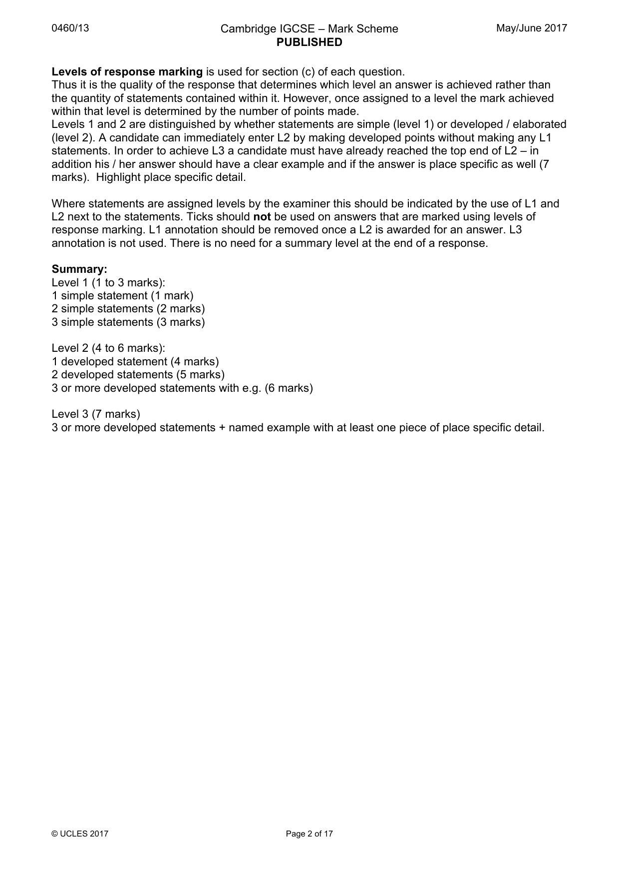
0460/13 Cambridge IGCSE – Mark Scheme PUBLISHED May/June 2017 © UCLES 2017 Page 2 of 17 Levels of response marking is used for section (c) of each question. Thus it is the quality of the response that determines which level an answer is achieved rather than the quantity of statements contained within it. However, once assigned to a level the mark achieved within that level is determined by the number of points made. Levels 1 and 2 are distinguished by whether statements are simple (level 1) or developed / elaborated (level 2). A candidate can immediately enter L2 by making developed points without making any L1 statements. In order to achieve L3 a candidate must have already reached the top end of L2 – in addition his / her answer should have a clear example and if the answer is place specific as well (7 marks). Highlight place specific detail. Where statements are assigned levels by the examiner this should be indicated by the use of L1 and L2 next to the statements. Ticks should not be used on answers that are marked using levels of response marking. L1 annotation should be removed once a L2 is awarded for an answer. L3 annotation is not used. There is no need for a summary level at the end of a response. Summary: Level 1 (1 to 3 marks): 1 simple statement (1 mark) 2 simple statements (2 marks) 3 simple statements (3 marks) Level 2 (4 to 6 marks): 1 developed statement (4 marks) 2 developed statements (5 marks) 3 or more developed statements with e.g. (6 marks) Level 3 (7 marks) 3 or more developed statements + named example with at least one piece of place specific detail.
Mark scheme, page 3
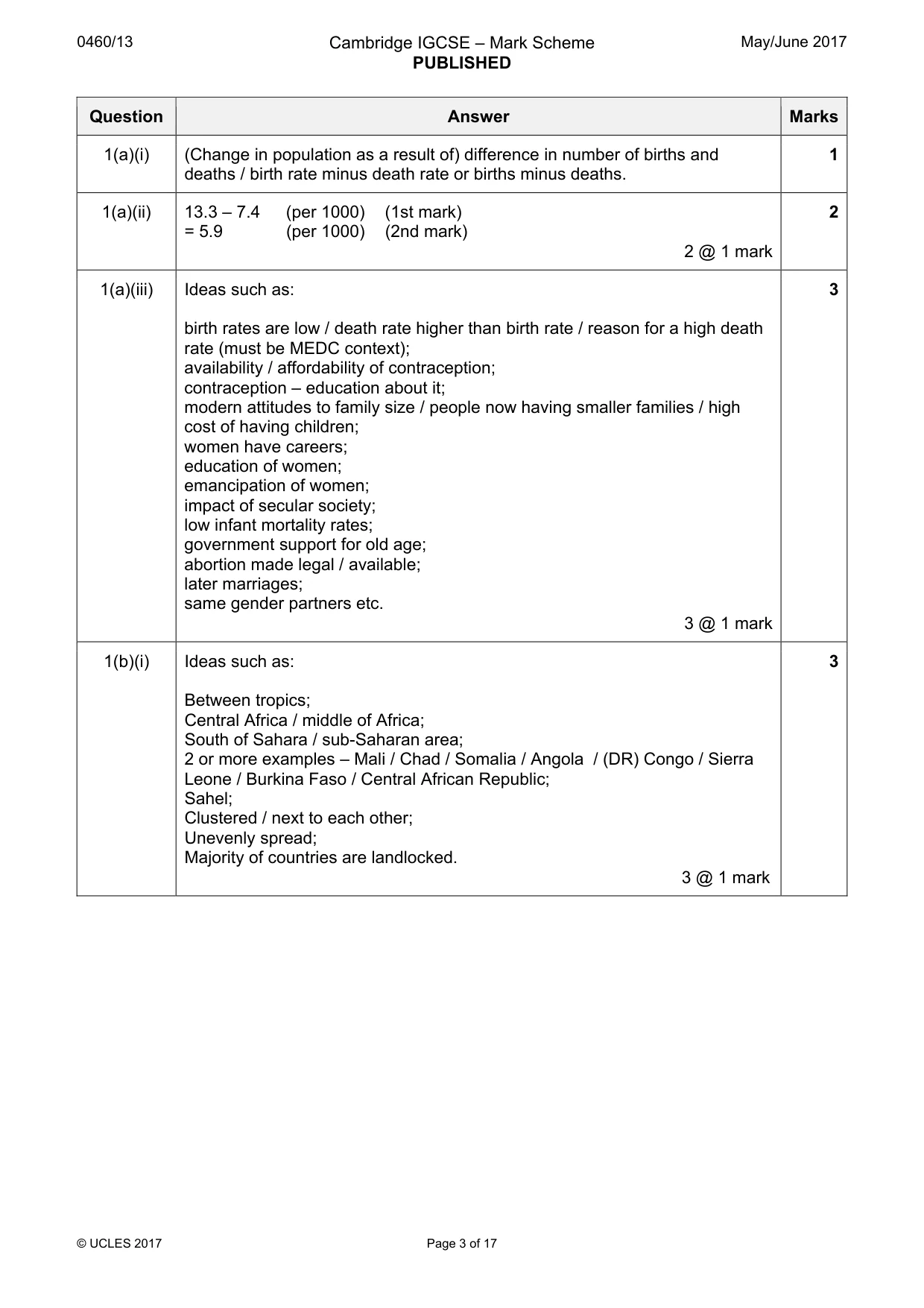
0460/13 Cambridge IGCSE – Mark Scheme PUBLISHED May/June 2017 © UCLES 2017 Page 3 of 17 Question Answer Marks 1(a)(i) (Change in population as a result of) difference in number of births and deaths / birth rate minus death rate or births minus deaths. 1 1(a)(ii) 13.3 – 7.4 (per 1000) (1st mark) = 5.9 (per 1000) (2nd mark) 2 @ 1 mark 2 1(a)(iii) Ideas such as: birth rates are low / death rate higher than birth rate / reason for a high death rate (must be MEDC context); availability / affordability of contraception; contraception – education about it; modern attitudes to family size / people now having smaller families / high cost of having children; women have careers; education of women; emancipation of women; impact of secular society; low infant mortality rates; government support for old age; abortion made legal / available; later marriages; same gender partners etc. 3 @ 1 mark 3 1(b)(i) Ideas such as: Between tropics; Central Africa / middle of Africa; South of Sahara / sub-Saharan area; 2 or more examples – Mali / Chad / Somalia / Angola / (DR) Congo / Sierra Leone / Burkina Faso / Central African Republic; Sahel; Clustered / next to each other; Unevenly spread; Majority of countries are landlocked. 3 @ 1 mark 3
Mark scheme, page 4
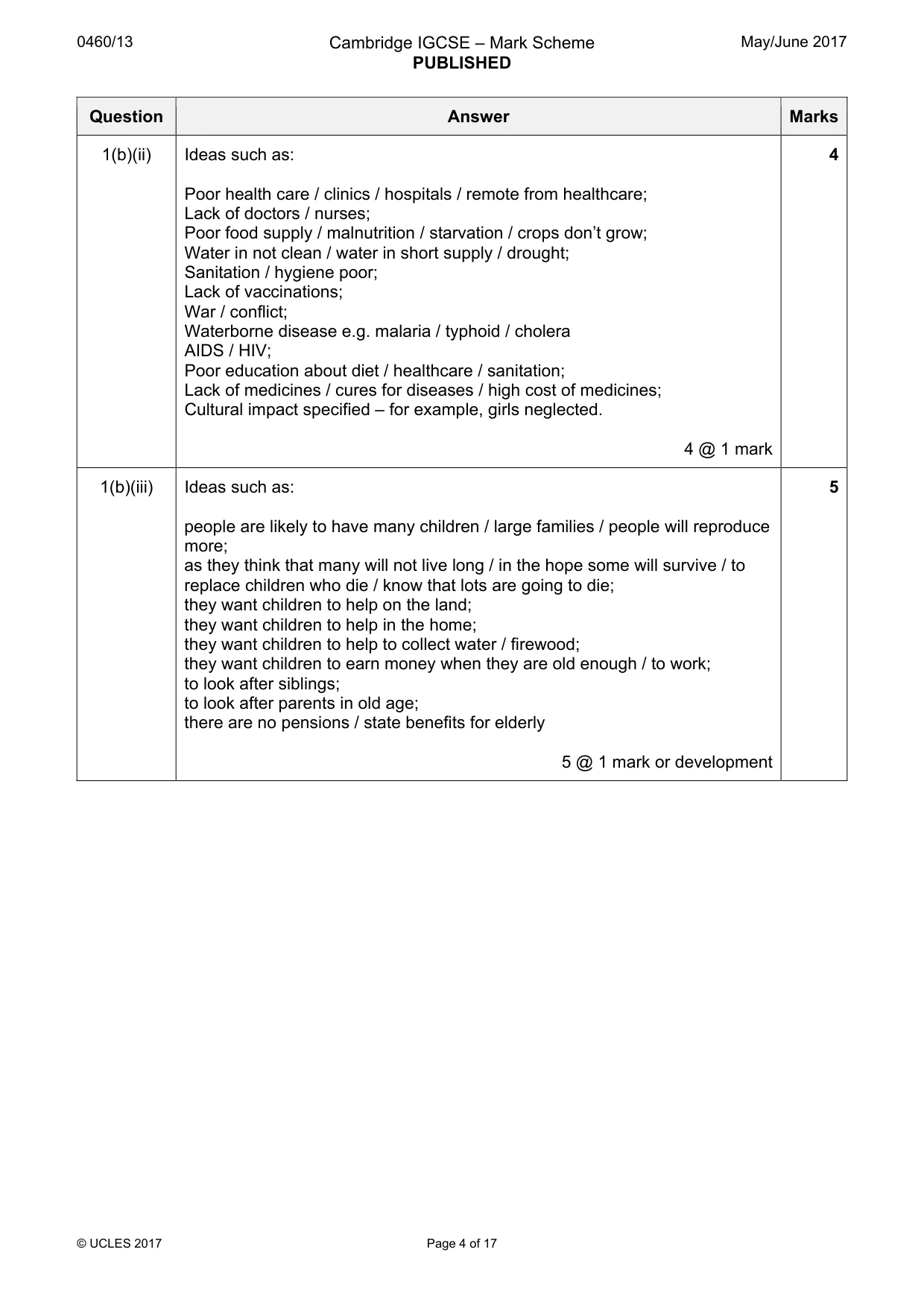
0460/13 Cambridge IGCSE – Mark Scheme PUBLISHED May/June 2017 © UCLES 2017 Page 4 of 17 Question Answer Marks 1(b)(ii) Ideas such as: Poor health care / clinics / hospitals / remote from healthcare; Lack of doctors / nurses; Poor food supply / malnutrition / starvation / crops don’t grow; Water in not clean / water in short supply / drought; Sanitation / hygiene poor; Lack of vaccinations; War / conflict; Waterborne disease e.g. malaria / typhoid / cholera AIDS / HIV; Poor education about diet / healthcare / sanitation; Lack of medicines / cures for diseases / high cost of medicines; Cultural impact specified – for example, girls neglected. 4 @ 1 mark 4 1(b)(iii) Ideas such as: people are likely to have many children / large families / people will reproduce more; as they think that many will not live long / in the hope some will survive / to replace children who die / know that lots are going to die; they want children to help on the land; they want children to help in the home; they want children to help to collect water / firewood; they want children to earn money when they are old enough / to work; to look after siblings; to look after parents in old age; there are no pensions / state benefits for elderly 5 @ 1 mark or development 5
Mark scheme, page 5
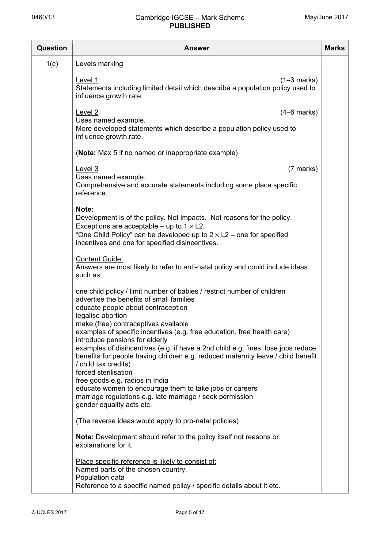
0460/13 Cambridge IGCSE – Mark Scheme PUBLISHED May/June 2017 © UCLES 2017 Page 5 of 17 Question Answer Marks 1(c) Levels marking Level 1 (1–3 marks) Statements including limited detail which describe a population policy used to influence growth rate. Level 2 (4–6 marks) Uses named example. More developed statements which describe a population policy used to influence growth rate. (Note: Max 5 if no named or inappropriate example) Level 3 (7 marks) Uses named example. Comprehensive and accurate statements including some place specific reference. Note: Development is of the policy. Not impacts. Not reasons for the policy. Exceptions are acceptable – up to 1 × L2. “One Child Policy” can be developed up to 2 × L2 – one for specified incentives and one for specified disincentives. Content Guide: Answers are most likely to refer to anti-natal policy and could include ideas such as: one child policy / limit number of babies / restrict number of children advertise the benefits of small families educate people about contraception legalise abortion make (free) contraceptives available examples of specific incentives (e.g. free education, free health care) introduce pensions for elderly examples of disincentives (e.g. if have a 2nd child e.g. fines, lose jobs reduce benefits for people having children e.g. reduced maternity leave / child benefit / child tax credits) forced sterilisation free goods e.g. radios in India educate women to encourage them to take jobs or careers marriage regulations e.g. late marriage / seek permission gender equality acts etc. (The reverse ideas would apply to pro-natal policies) Note: Development should refer to the policy itself not reasons or explanations for it. Place specific reference is likely to consist of: Named parts of the chosen country, Population data Reference to a specific named policy / specific details about it etc.
Mark scheme, page 6
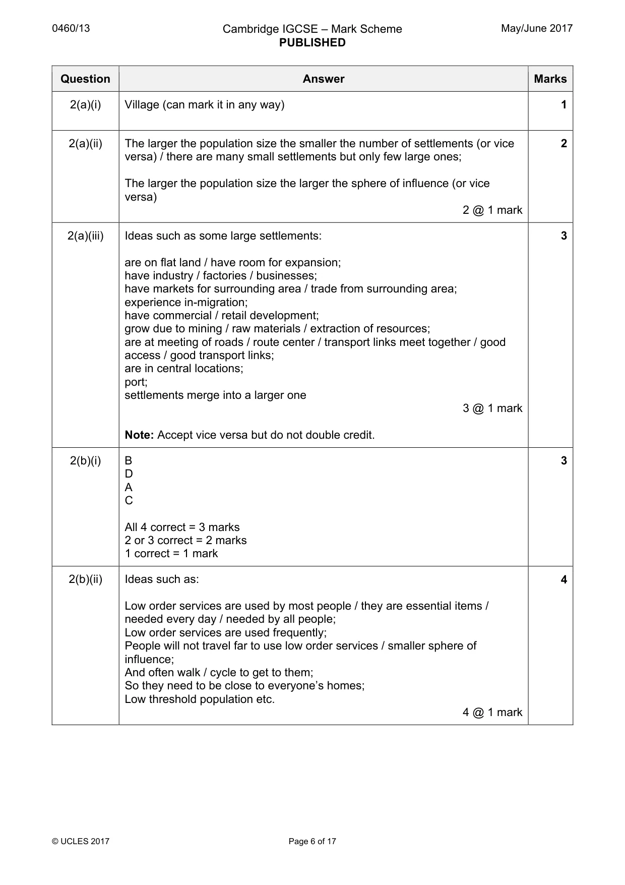
0460/13 Cambridge IGCSE – Mark Scheme PUBLISHED May/June 2017 © UCLES 2017 Page 6 of 17 Question Answer Marks 2(a)(i) Village (can mark it in any way) 1 2(a)(ii) The larger the population size the smaller the number of settlements (or vice versa) / there are many small settlements but only few large ones; The larger the population size the larger the sphere of influence (or vice versa) 2 @ 1 mark 2 2(a)(iii) Ideas such as some large settlements: are on flat land / have room for expansion; have industry / factories / businesses; have markets for surrounding area / trade from surrounding area; experience in-migration; have commercial / retail development; grow due to mining / raw materials / extraction of resources; are at meeting of roads / route center / transport links meet together / good access / good transport links; are in central locations; port; settlements merge into a larger one 3 @ 1 mark Note: Accept vice versa but do not double credit. 3 2(b)(i) B D A C All 4 correct = 3 marks 2 or 3 correct = 2 marks 1 correct = 1 mark 3 2(b)(ii) Ideas such as: Low order services are used by most people / they are essential items / needed every day / needed by all people; Low order services are used frequently; People will not travel far to use low order services / smaller sphere of influence; And often walk / cycle to get to them; So they need to be close to everyone’s homes; Low threshold population etc. 4 @ 1 mark 4
Mark scheme, page 7
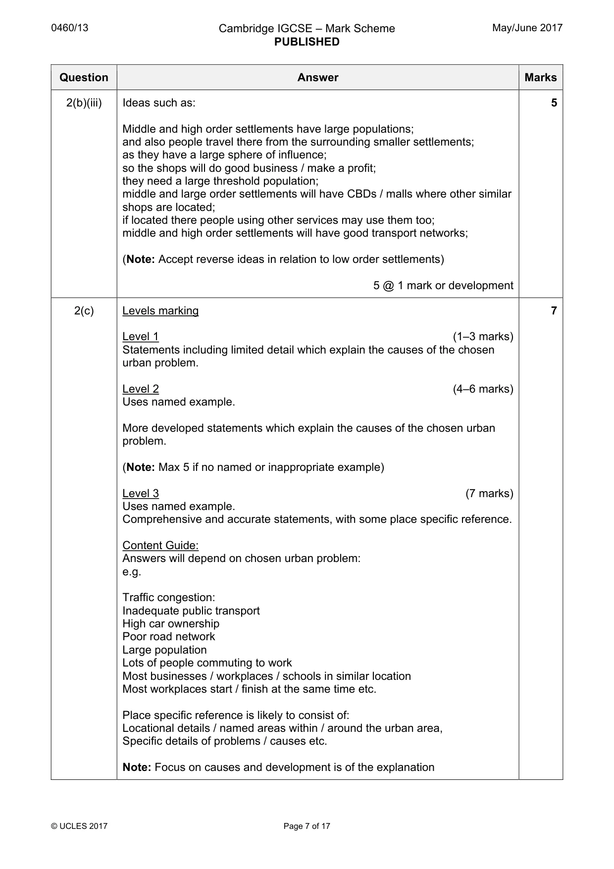
0460/13 Cambridge IGCSE – Mark Scheme PUBLISHED May/June 2017 © UCLES 2017 Page 7 of 17 Question Answer Marks 2(b)(iii) Ideas such as: Middle and high order settlements have large populations; and also people travel there from the surrounding smaller settlements; as they have a large sphere of influence; so the shops will do good business / make a profit; they need a large threshold population; middle and large order settlements will have CBDs / malls where other similar shops are located; if located there people using other services may use them too; middle and high order settlements will have good transport networks; (Note: Accept reverse ideas in relation to low order settlements) 5 @ 1 mark or development 5 2(c) Levels marking Level 1 (1–3 marks) Statements including limited detail which explain the causes of the chosen urban problem. Level 2 (4–6 marks) Uses named example. More developed statements which explain the causes of the chosen urban problem. (Note: Max 5 if no named or inappropriate example) Level 3 (7 marks) Uses named example. Comprehensive and accurate statements, with some place specific reference. Content Guide: Answers will depend on chosen urban problem: e.g. Traffic congestion: Inadequate public transport High car ownership Poor road network Large population Lots of people commuting to work Most businesses / workplaces / schools in similar location Most workplaces start / finish at the same time etc. Place specific reference is likely to consist of: Locational details / named areas within / around the urban area, Specific details of problems / causes etc. Note: Focus on causes and development is of the explanation 7
Mark scheme, page 8
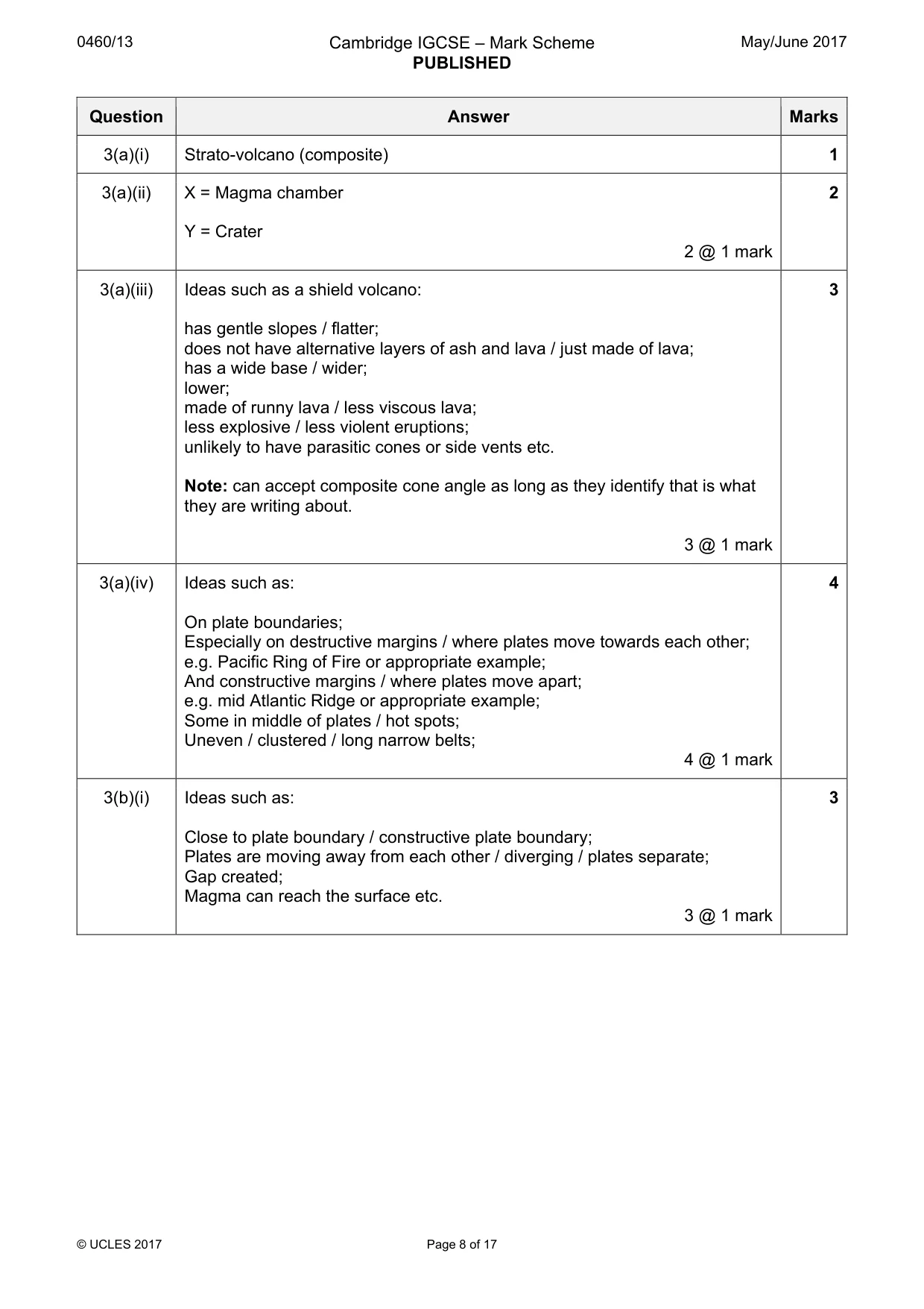
0460/13 Cambridge IGCSE – Mark Scheme PUBLISHED May/June 2017 © UCLES 2017 Page 8 of 17 Question Answer Marks 3(a)(i) Strato-volcano (composite) 1 3(a)(ii) X = Magma chamber Y = Crater 2 @ 1 mark 2 3(a)(iii) Ideas such as a shield volcano: has gentle slopes / flatter; does not have alternative layers of ash and lava / just made of lava; has a wide base / wider; lower; made of runny lava / less viscous lava; less explosive / less violent eruptions; unlikely to have parasitic cones or side vents etc. Note: can accept composite cone angle as long as they identify that is what they are writing about. 3 @ 1 mark 3 3(a)(iv) Ideas such as: On plate boundaries; Especially on destructive margins / where plates move towards each other; e.g. Pacific Ring of Fire or appropriate example; And constructive margins / where plates move apart; e.g. mid Atlantic Ridge or appropriate example; Some in middle of plates / hot spots; Uneven / clustered / long narrow belts; 4 @ 1 mark 4 3(b)(i) Ideas such as: Close to plate boundary / constructive plate boundary; Plates are moving away from each other / diverging / plates separate; Gap created; Magma can reach the surface etc. 3 @ 1 mark 3
Mark scheme, page 9
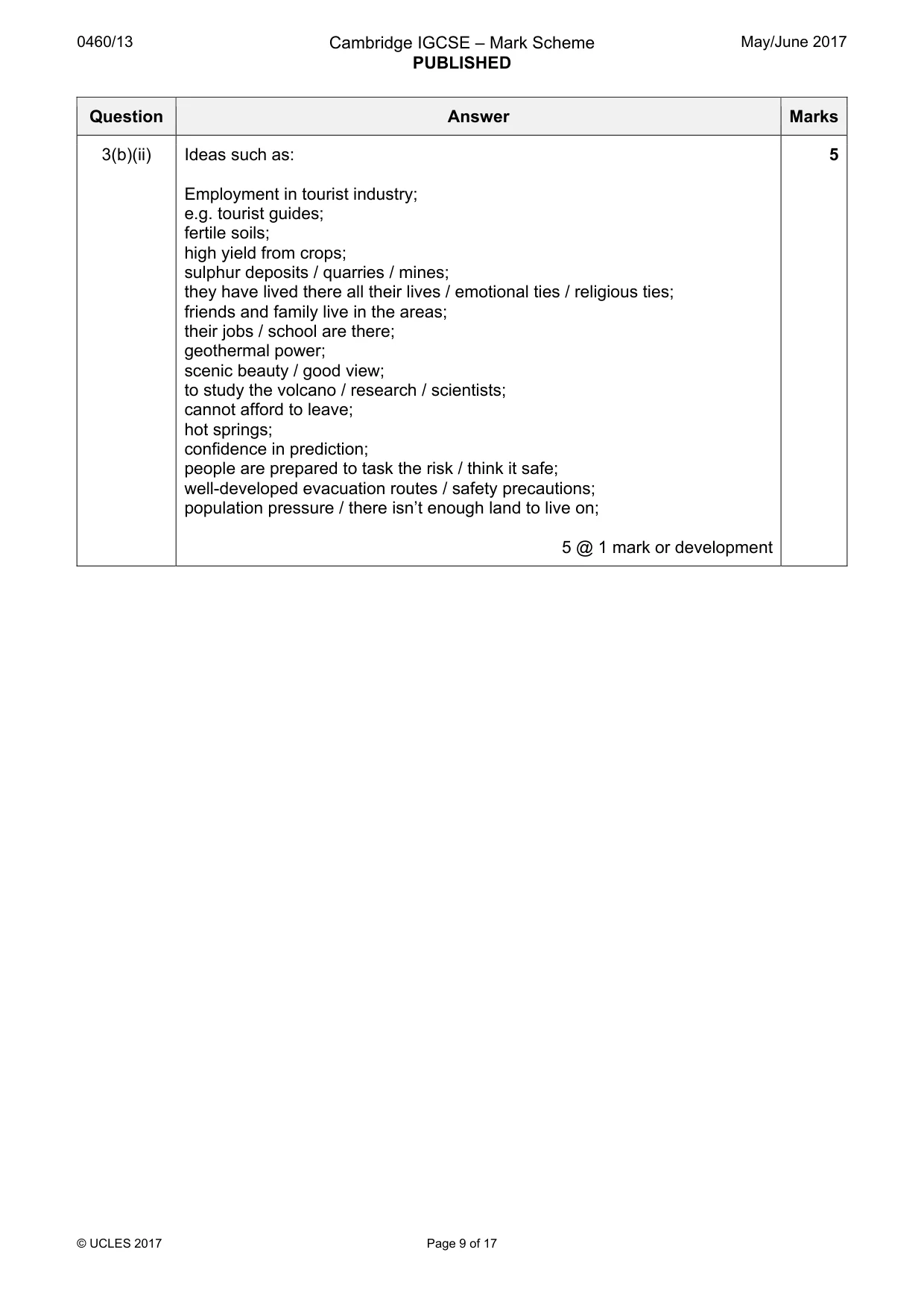
0460/13 Cambridge IGCSE – Mark Scheme PUBLISHED May/June 2017 © UCLES 2017 Page 9 of 17 Question Answer Marks 3(b)(ii) Ideas such as: Employment in tourist industry; e.g. tourist guides; fertile soils; high yield from crops; sulphur deposits / quarries / mines; they have lived there all their lives / emotional ties / religious ties; friends and family live in the areas; their jobs / school are there; geothermal power; scenic beauty / good view; to study the volcano / research / scientists; cannot afford to leave; hot springs; confidence in prediction; people are prepared to task the risk / think it safe; well-developed evacuation routes / safety precautions; population pressure / there isn’t enough land to live on; 5 @ 1 mark or development 5
Mark scheme, page 10
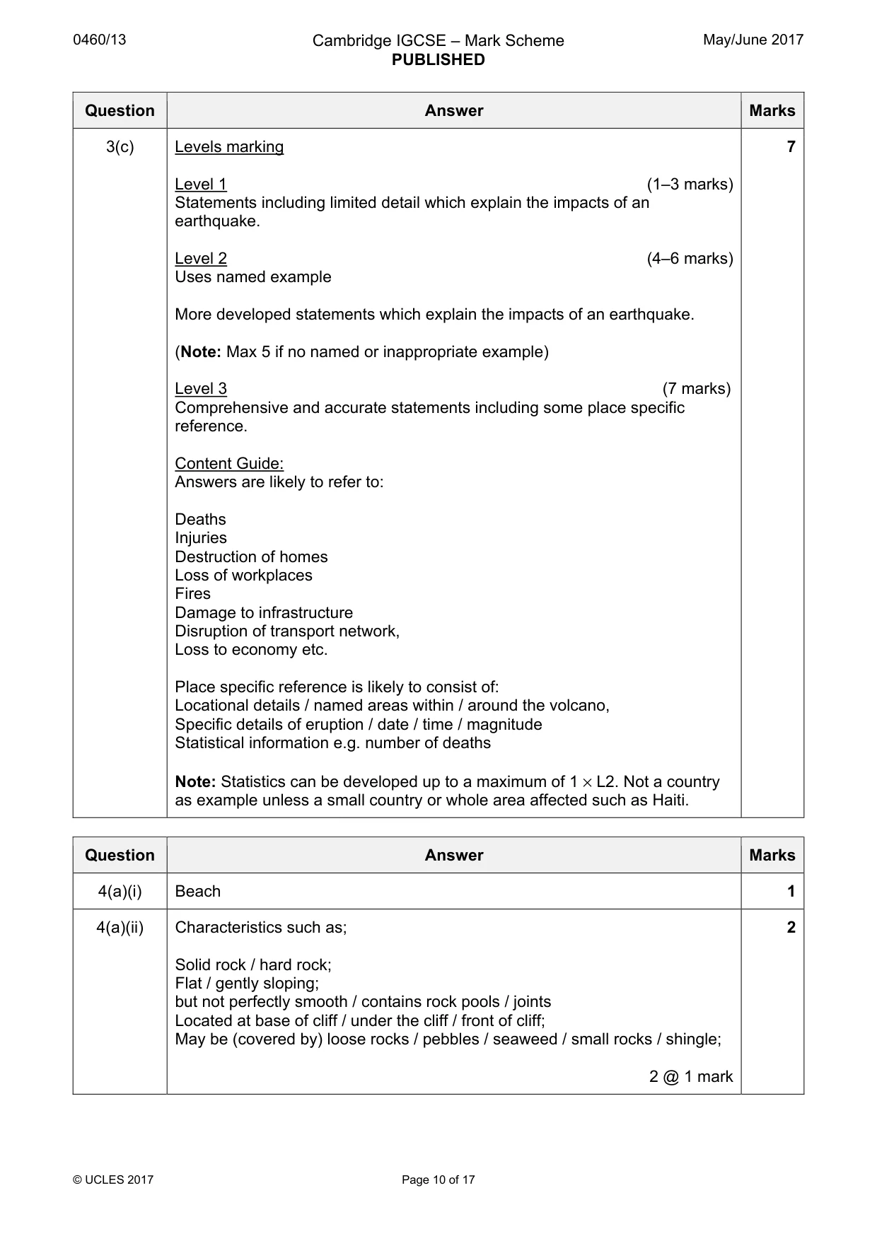
0460/13 Cambridge IGCSE – Mark Scheme PUBLISHED May/June 2017 © UCLES 2017 Page 10 of 17 Question Answer Marks 3(c) Levels marking Level 1 (1–3 marks) Statements including limited detail which explain the impacts of an earthquake. Level 2 (4–6 marks) Uses named example More developed statements which explain the impacts of an earthquake. (Note: Max 5 if no named or inappropriate example) Level 3 (7 marks) Comprehensive and accurate statements including some place specific reference. Content Guide: Answers are likely to refer to: Deaths Injuries Destruction of homes Loss of workplaces Fires Damage to infrastructure Disruption of transport network, Loss to economy etc. Place specific reference is likely to consist of: Locational details / named areas within / around the volcano, Specific details of eruption / date / time / magnitude Statistical information e.g. number of deaths Note: Statistics can be developed up to a maximum of 1 × L2. Not a country as example unless a small country or whole area affected such as Haiti. 7 Question Answer Marks 4(a)(i) Beach 1 4(a)(ii) Characteristics such as; Solid rock / hard rock; Flat / gently sloping; but not perfectly smooth / contains rock pools / joints Located at base of cliff / under the cliff / front of cliff; May be (covered by) loose rocks / pebbles / seaweed / small rocks / shingle; 2 @ 1 mark 2
Mark scheme, page 11
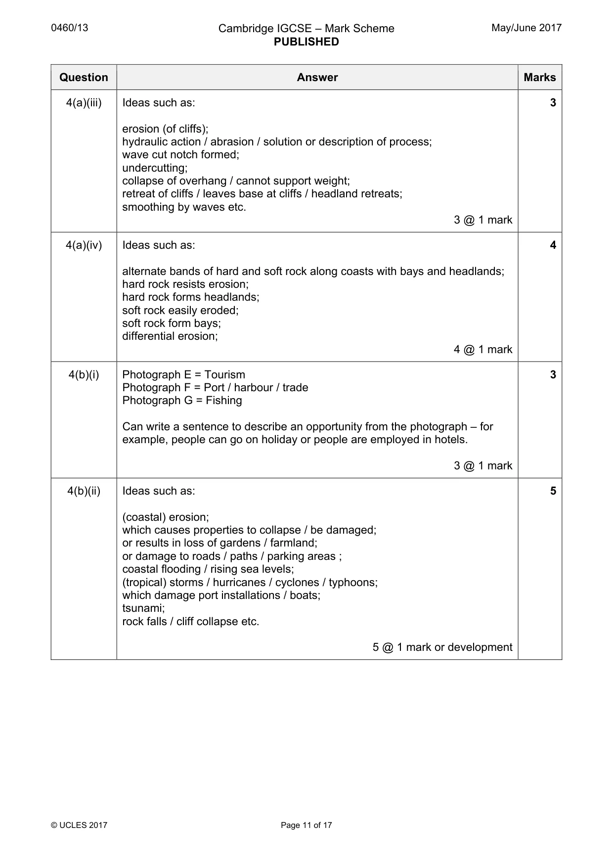
0460/13 Cambridge IGCSE – Mark Scheme PUBLISHED May/June 2017 © UCLES 2017 Page 11 of 17 Question Answer Marks 4(a)(iii) Ideas such as: erosion (of cliffs); hydraulic action / abrasion / solution or description of process; wave cut notch formed; undercutting; collapse of overhang / cannot support weight; retreat of cliffs / leaves base at cliffs / headland retreats; smoothing by waves etc. 3 @ 1 mark 3 4(a)(iv) Ideas such as: alternate bands of hard and soft rock along coasts with bays and headlands; hard rock resists erosion; hard rock forms headlands; soft rock easily eroded; soft rock form bays; differential erosion; 4 @ 1 mark 4 4(b)(i) Photograph E = Tourism Photograph F = Port / harbour / trade Photograph G = Fishing Can write a sentence to describe an opportunity from the photograph – for example, people can go on holiday or people are employed in hotels. 3 @ 1 mark 3 4(b)(ii) Ideas such as: (coastal) erosion; which causes properties to collapse / be damaged; or results in loss of gardens / farmland; or damage to roads / paths / parking areas ; coastal flooding / rising sea levels; (tropical) storms / hurricanes / cyclones / typhoons; which damage port installations / boats; tsunami; rock falls / cliff collapse etc. 5 @ 1 mark or development 5
Mark scheme, page 12
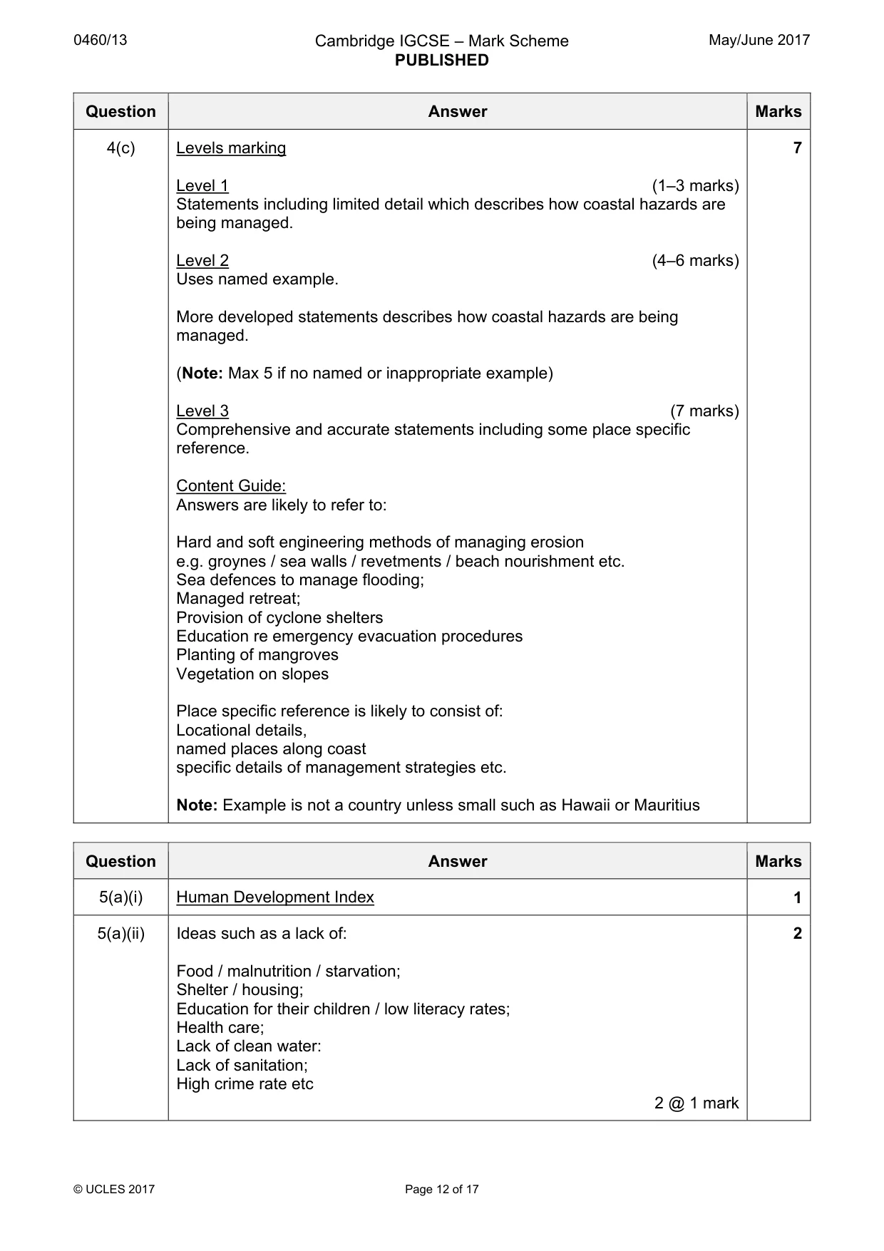
0460/13 Cambridge IGCSE – Mark Scheme PUBLISHED May/June 2017 © UCLES 2017 Page 12 of 17 Question Answer Marks 4(c) Levels marking Level 1 (1–3 marks) Statements including limited detail which describes how coastal hazards are being managed. Level 2 (4–6 marks) Uses named example. More developed statements describes how coastal hazards are being managed. (Note: Max 5 if no named or inappropriate example) Level 3 (7 marks) Comprehensive and accurate statements including some place specific reference. Content Guide: Answers are likely to refer to: Hard and soft engineering methods of managing erosion e.g. groynes / sea walls / revetments / beach nourishment etc. Sea defences to manage flooding; Managed retreat; Provision of cyclone shelters Education re emergency evacuation procedures Planting of mangroves Vegetation on slopes Place specific reference is likely to consist of: Locational details, named places along coast specific details of management strategies etc. Note: Example is not a country unless small such as Hawaii or Mauritius 7 Question Answer Marks 5(a)(i) Human Development Index 1 5(a)(ii) Ideas such as a lack of: Food / malnutrition / starvation; Shelter / housing; Education for their children / low literacy rates; Health care; Lack of clean water: Lack of sanitation; High crime rate etc 2 @ 1 mark 2
Mark scheme, page 13
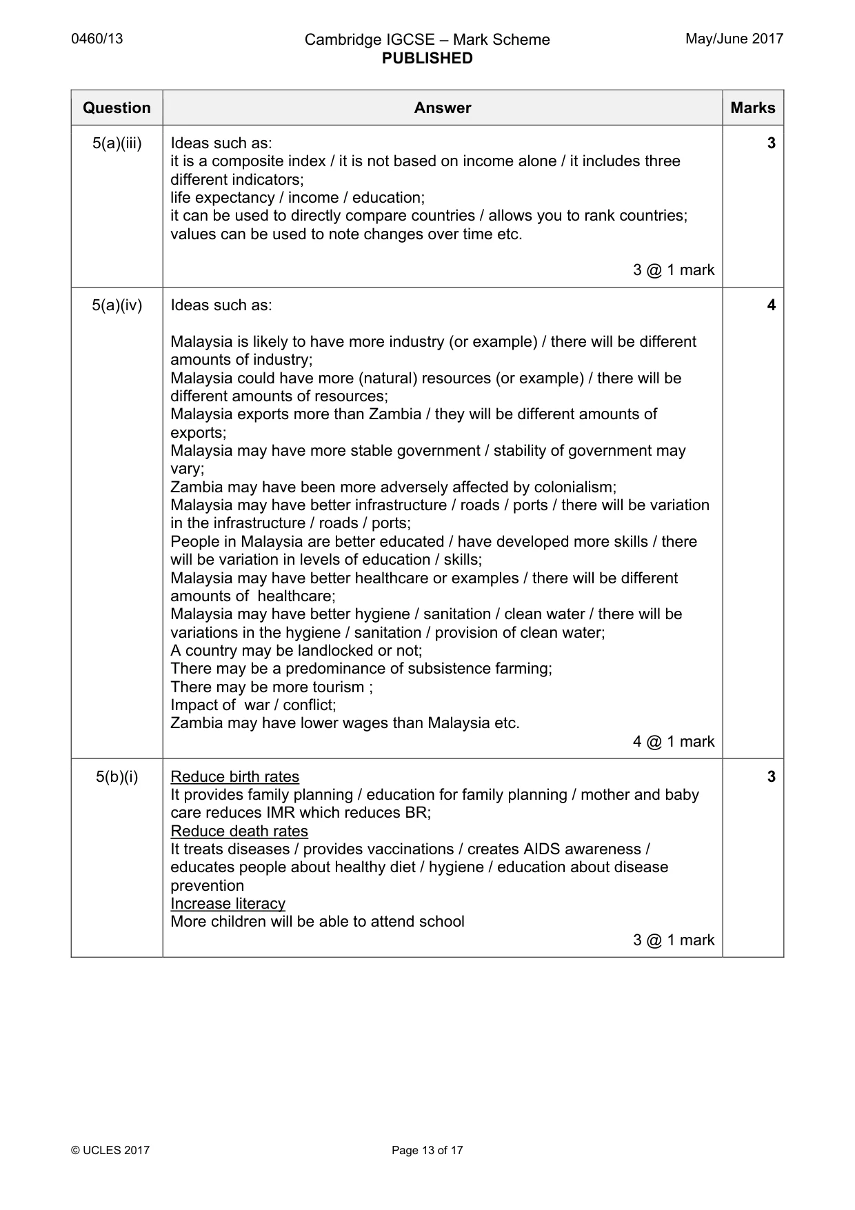
0460/13 Cambridge IGCSE – Mark Scheme PUBLISHED May/June 2017 © UCLES 2017 Page 13 of 17 Question Answer Marks 5(a)(iii) Ideas such as: it is a composite index / it is not based on income alone / it includes three different indicators; life expectancy / income / education; it can be used to directly compare countries / allows you to rank countries; values can be used to note changes over time etc. 3 @ 1 mark 3 5(a)(iv) Ideas such as: Malaysia is likely to have more industry (or example) / there will be different amounts of industry; Malaysia could have more (natural) resources (or example) / there will be different amounts of resources; Malaysia exports more than Zambia / they will be different amounts of exports; Malaysia may have more stable government / stability of government may vary; Zambia may have been more adversely affected by colonialism; Malaysia may have better infrastructure / roads / ports / there will be variation in the infrastructure / roads / ports; People in Malaysia are better educated / have developed more skills / there will be variation in levels of education / skills; Malaysia may have better healthcare or examples / there will be different amounts of healthcare; Malaysia may have better hygiene / sanitation / clean water / there will be variations in the hygiene / sanitation / provision of clean water; A country may be landlocked or not; There may be a predominance of subsistence farming; There may be more tourism ; Impact of war / conflict; Zambia may have lower wages than Malaysia etc. 4 @ 1 mark 4 5(b)(i) Reduce birth rates It provides family planning / education for family planning / mother and baby care reduces IMR which reduces BR; Reduce death rates It treats diseases / provides vaccinations / creates AIDS awareness / educates people about healthy diet / hygiene / education about disease prevention Increase literacy More children will be able to attend school 3 @ 1 mark 3
Mark scheme, page 14
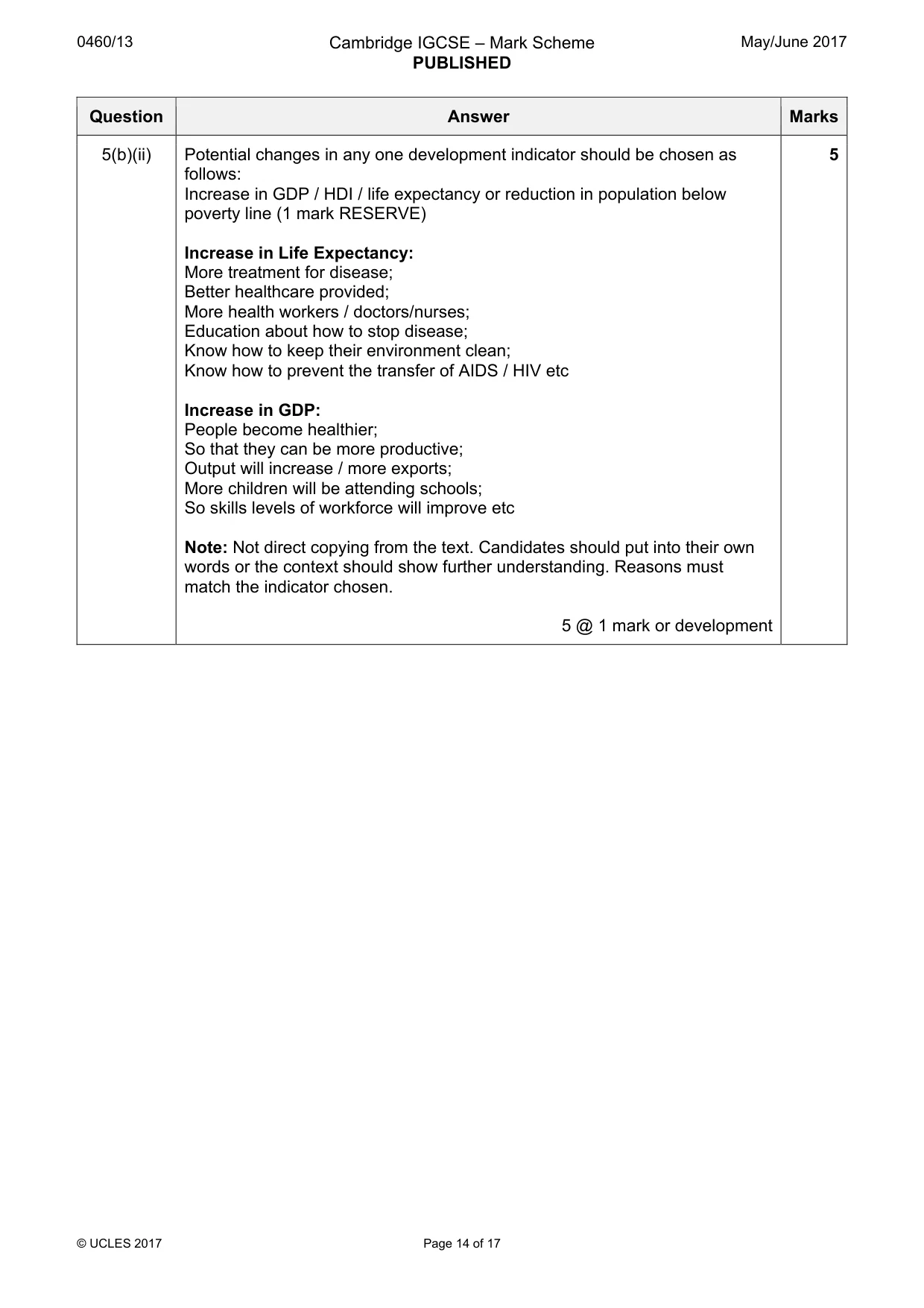
0460/13 Cambridge IGCSE – Mark Scheme PUBLISHED May/June 2017 © UCLES 2017 Page 14 of 17 Question Answer Marks 5(b)(ii) Potential changes in any one development indicator should be chosen as follows: Increase in GDP / HDI / life expectancy or reduction in population below poverty line (1 mark RESERVE) Increase in Life Expectancy: More treatment for disease; Better healthcare provided; More health workers / doctors/nurses; Education about how to stop disease; Know how to keep their environment clean; Know how to prevent the transfer of AIDS / HIV etc Increase in GDP: People become healthier; So that they can be more productive; Output will increase / more exports; More children will be attending schools; So skills levels of workforce will improve etc Note: Not direct copying from the text. Candidates should put into their own words or the context should show further understanding. Reasons must match the indicator chosen. 5 @ 1 mark or development 5
Mark scheme, page 15
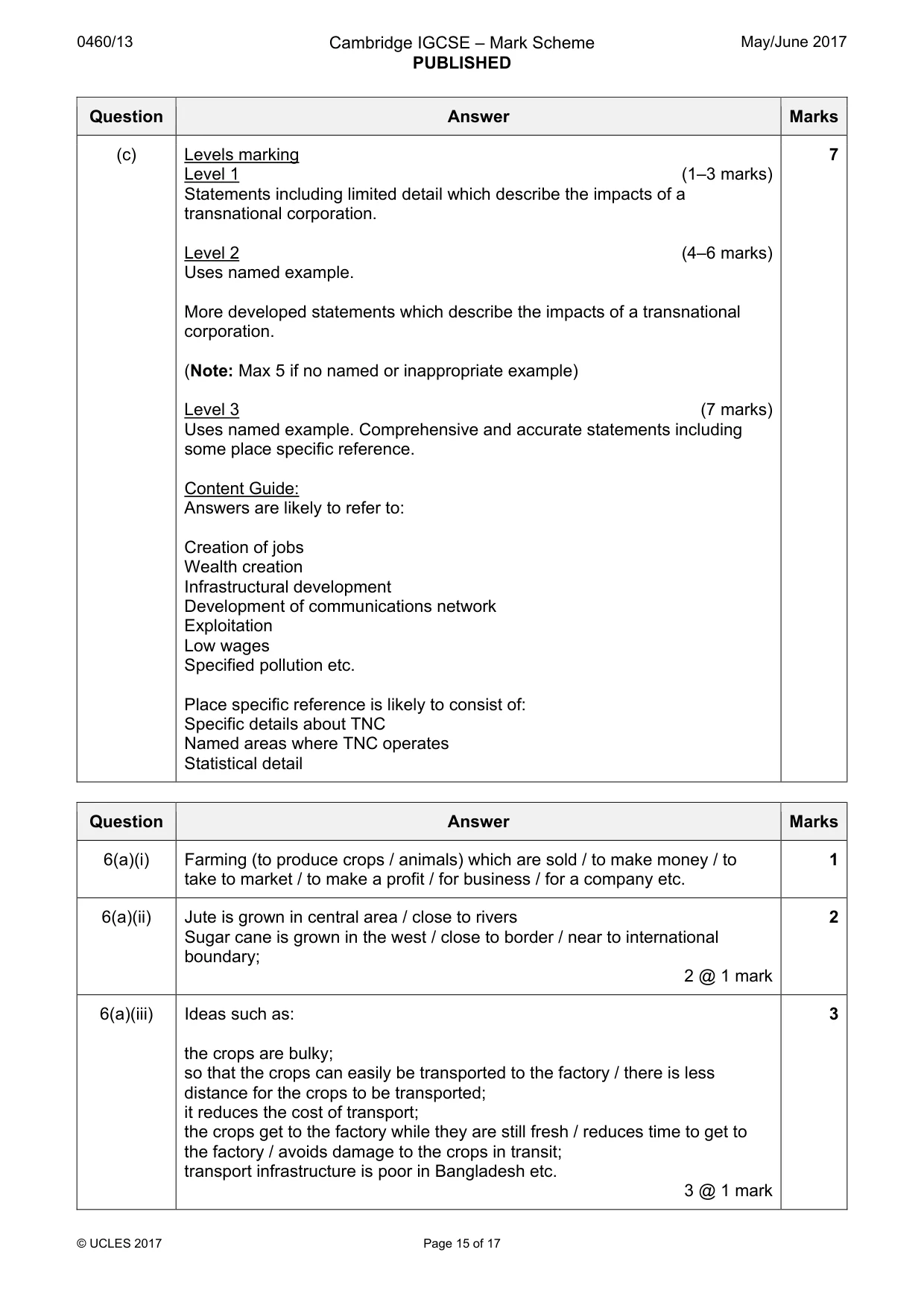
0460/13 Cambridge IGCSE – Mark Scheme PUBLISHED May/June 2017 © UCLES 2017 Page 15 of 17 Question Answer Marks (c) Levels marking Level 1 (1–3 marks) Statements including limited detail which describe the impacts of a transnational corporation. Level 2 (4–6 marks) Uses named example. More developed statements which describe the impacts of a transnational corporation. (Note: Max 5 if no named or inappropriate example) Level 3 (7 marks) Uses named example. Comprehensive and accurate statements including some place specific reference. Content Guide: Answers are likely to refer to: Creation of jobs Wealth creation Infrastructural development Development of communications network Exploitation Low wages Specified pollution etc. Place specific reference is likely to consist of: Specific details about TNC Named areas where TNC operates Statistical detail 7 Question Answer Marks 6(a)(i) Farming (to produce crops / animals) which are sold / to make money / to take to market / to make a profit / for business / for a company etc. 1 6(a)(ii) Jute is grown in central area / close to rivers Sugar cane is grown in the west / close to border / near to international boundary; 2 @ 1 mark 2 6(a)(iii) Ideas such as: the crops are bulky; so that the crops can easily be transported to the factory / there is less distance for the crops to be transported; it reduces the cost of transport; the crops get to the factory while they are still fresh / reduces time to get to the factory / avoids damage to the crops in transit; transport infrastructure is poor in Bangladesh etc. 3 @ 1 mark 3
Mark scheme, page 16
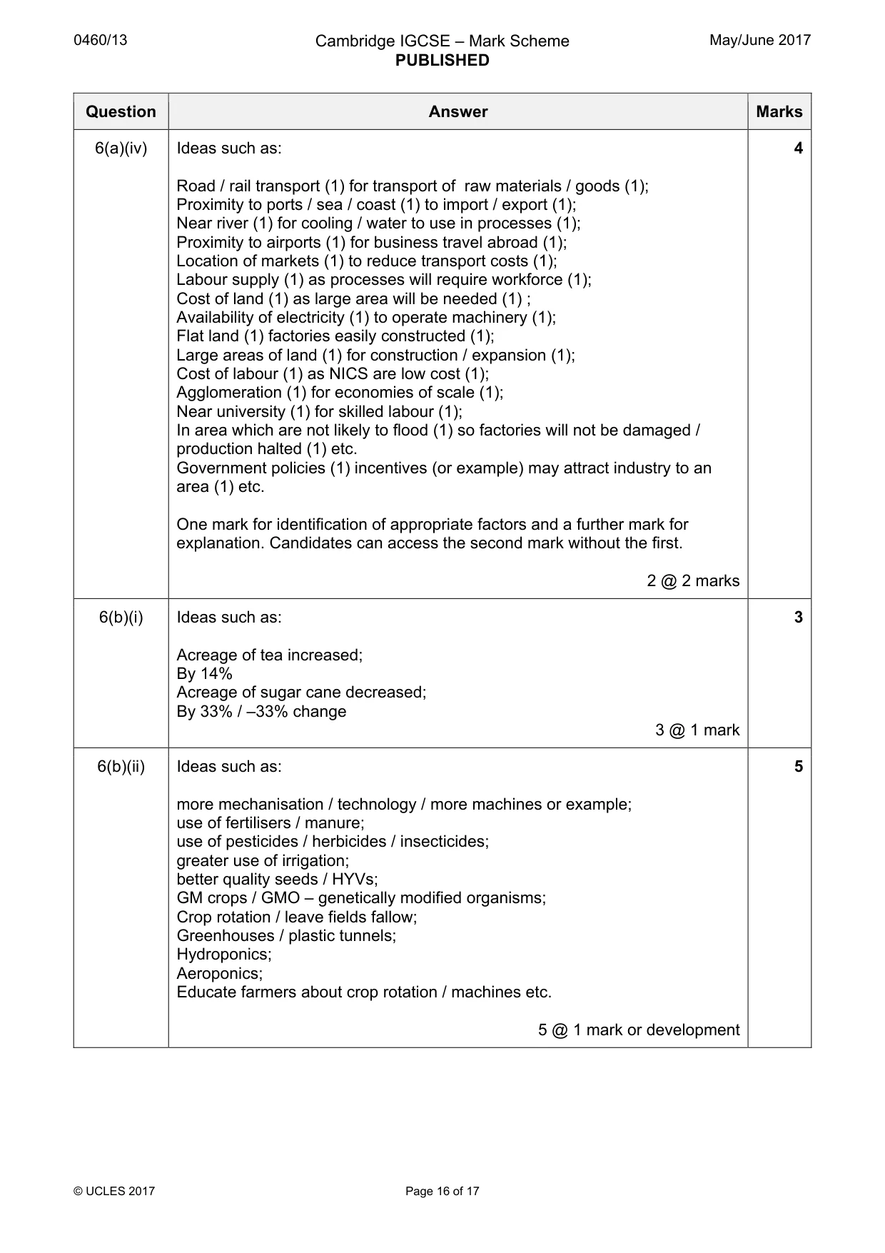
0460/13 Cambridge IGCSE – Mark Scheme PUBLISHED May/June 2017 © UCLES 2017 Page 16 of 17 Question Answer Marks 6(a)(iv) Ideas such as: Road / rail transport (1) for transport of raw materials / goods (1); Proximity to ports / sea / coast (1) to import / export (1); Near river (1) for cooling / water to use in processes (1); Proximity to airports (1) for business travel abroad (1); Location of markets (1) to reduce transport costs (1); Labour supply (1) as processes will require workforce (1); Cost of land (1) as large area will be needed (1) ; Availability of electricity (1) to operate machinery (1); Flat land (1) factories easily constructed (1); Large areas of land (1) for construction / expansion (1); Cost of labour (1) as NICS are low cost (1); Agglomeration (1) for economies of scale (1); Near university (1) for skilled labour (1); In area which are not likely to flood (1) so factories will not be damaged / production halted (1) etc. Government policies (1) incentives (or example) may attract industry to an area (1) etc. One mark for identification of appropriate factors and a further mark for explanation. Candidates can access the second mark without the first. 2 @ 2 marks 4 6(b)(i) Ideas such as: Acreage of tea increased; By 14% Acreage of sugar cane decreased; By 33% / –33% change 3 @ 1 mark 3 6(b)(ii) Ideas such as: more mechanisation / technology / more machines or example; use of fertilisers / manure; use of pesticides / herbicides / insecticides; greater use of irrigation; better quality seeds / HYVs; GM crops / GMO – genetically modified organisms; Crop rotation / leave fields fallow; Greenhouses / plastic tunnels; Hydroponics; Aeroponics; Educate farmers about crop rotation / machines etc. 5 @ 1 mark or development 5
Mark scheme, page 17
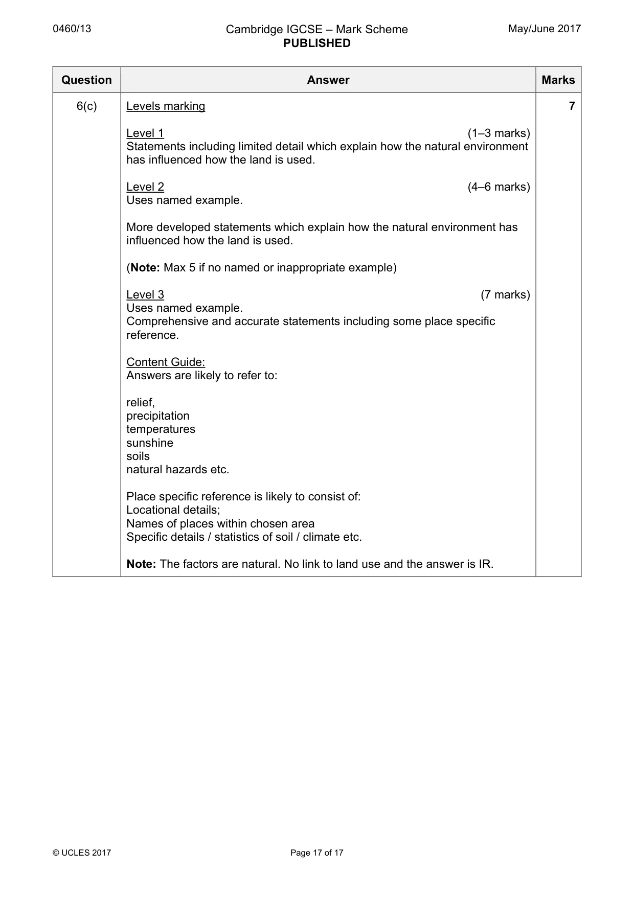
0460/13 Cambridge IGCSE – Mark Scheme PUBLISHED May/June 2017 © UCLES 2017 Page 17 of 17 Question Answer Marks 6(c) Levels marking Level 1 (1–3 marks) Statements including limited detail which explain how the natural environment has influenced how the land is used. Level 2 (4–6 marks) Uses named example. More developed statements which explain how the natural environment has influenced how the land is used. (Note: Max 5 if no named or inappropriate example) Level 3 (7 marks) Uses named example. Comprehensive and accurate statements including some place specific reference. Content Guide: Answers are likely to refer to: relief, precipitation temperatures sunshine soils natural hazards etc. Place specific reference is likely to consist of: Locational details; Names of places within chosen area Specific details / statistics of soil / climate etc. Note: The factors are natural. No link to land use and the answer is IR. 7
What you needed in this session
Cambridge’s own grade thresholds for 2017 May/June, Paper 1 · Variant 3. A higher threshold means an easier paper — the bar moves with how the cohort did.