Cambridge IGCSE Geography 0460 — 2014 Oct/Nov Paper 1 · Variant 1
0460/11/O/N/14 · 75 marks · ≈84 min
The question paper and its mark scheme, free to read here and free to download. This is Cambridge’s own paper, exactly as it was sat.
Question paper28 pages

Mark scheme13 pages
Answers below. Sit the paper first if you are practising.
Paper as text
Question paper, page 1
This document consists of 26 printed pages, 2 blank pages and 1 Insert. DC (NF/JG) 81512/10 © UCLES 2014 [Turn over Cambridge International Examinations Cambridge International General Certificate of Secondary Education * 6 1 0 6 8 0 6 6 1 8 * GEOGRAPHY 0460/11 Paper 1 October/November 2014 1 hour 45 minutes Candidates answer on the Question Paper. Additional Materials: Ruler Calculator READ THESE INSTRUCTIONS FIRST Write your Centre number, candidate number and name in the spaces provided. Write in dark blue or black pen. You may use an HB pencil for any diagrams or graphs. Do not use staples, paper clips, glue or correction fluid. DO NOT WRITE IN ANY BARCODES. Write your answer to each question in the space provided. If additional space is required, you should use the lined page at the end of this booklet. The question number(s) must be clearly shown. Answer three questions. The Insert contains Photographs A, B and C and Fig. 1B for Question 1, and Photographs D and E for Question 3. The Insert is not required by the Examiner. Sketch maps and diagrams should be drawn whenever they serve to illustrate an answer. At the end of the examination, fasten all your work securely together. The number of marks is given in brackets [ ] at the end of each question or part question. The syllabus is approved for use in England, Wales and Northern Ireland as a Cambridge International Level 1/Level 2 Certificate.
Question paper, page 2
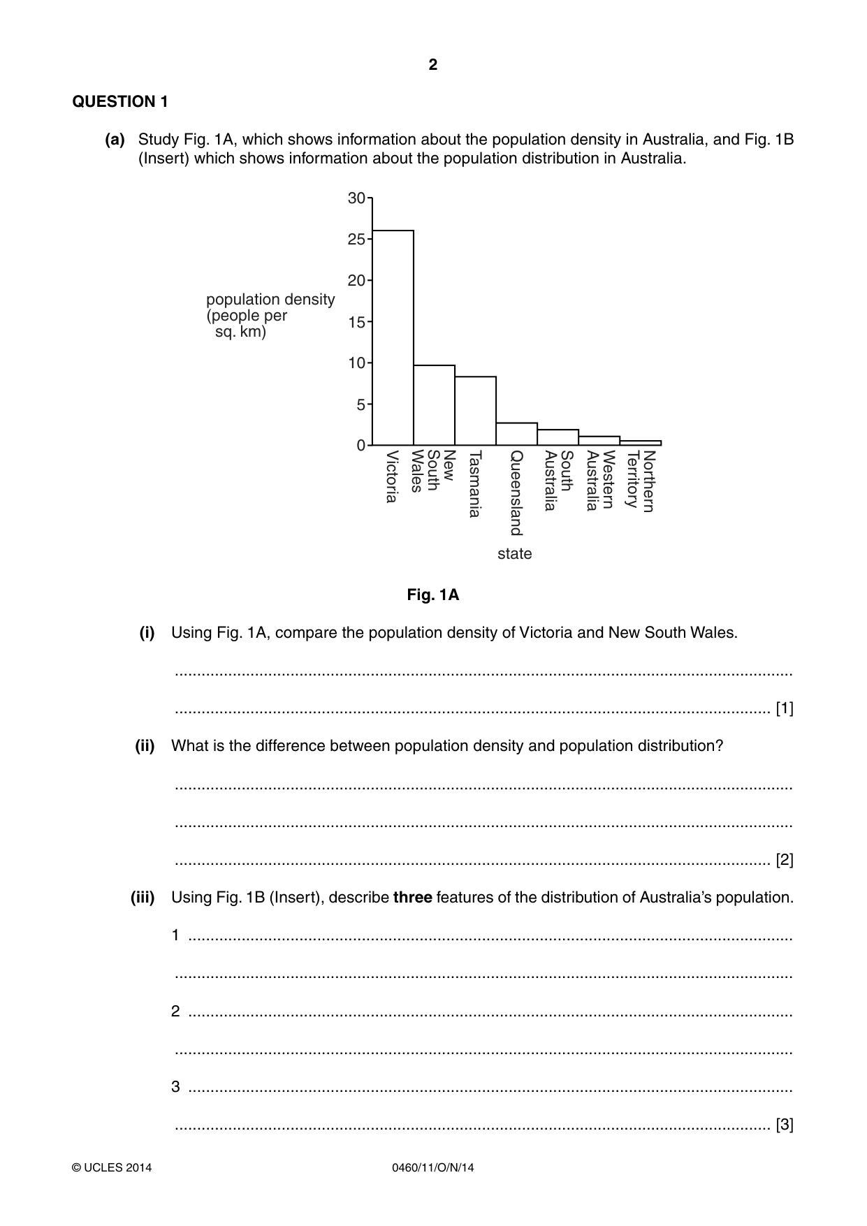
2 0460/11/O/N/14 © UCLES 2014 QUESTION 1 (a) Study Fig. 1A, which shows information about the population density in Australia, and Fig. 1B (Insert) which shows information about the population distribution in Australia. 30 25 20 15 10 5 0 Victoria Tasmania Queensland South Australia Western Australia Northern Territory New South Wales population density (people per sq. km) state Fig. 1A (i) Using Fig. 1A, compare the population density of Victoria and New South Wales. … … [1] (ii) What is the difference between population density and population distribution? … … … [2] (iii) Using Fig. 1B (Insert), describe three features of the distribution of Australia’s population. 1 … … 2 … … 3 … … [3]
Question paper, page 3
3 0460/11/O/N/14 © UCLES 2014 [Turn over (b) Study Photographs A, B and C (Insert), which show areas which are sparsely populated. (i) Give one reason why each of the areas shown has a low population density. You should choose a different reason for each photograph. Photograph A … … Photograph B … … Photograph C … … [3] (ii) Explain how climate can influence population density. … … … … … … … … [4] (iii) Explain why many coastal areas are densely populated. … … … … … … … … … … [5]
Question paper, page 4
4 0460/11/O/N/14 © UCLES 2014 (c) For a named country you have studied, explain why it has a high rate of population growth. Name of country … … … … … … … … … … … … … … … [7] [Total: 25 marks] END OF QUESTION 1
Question paper, page 5
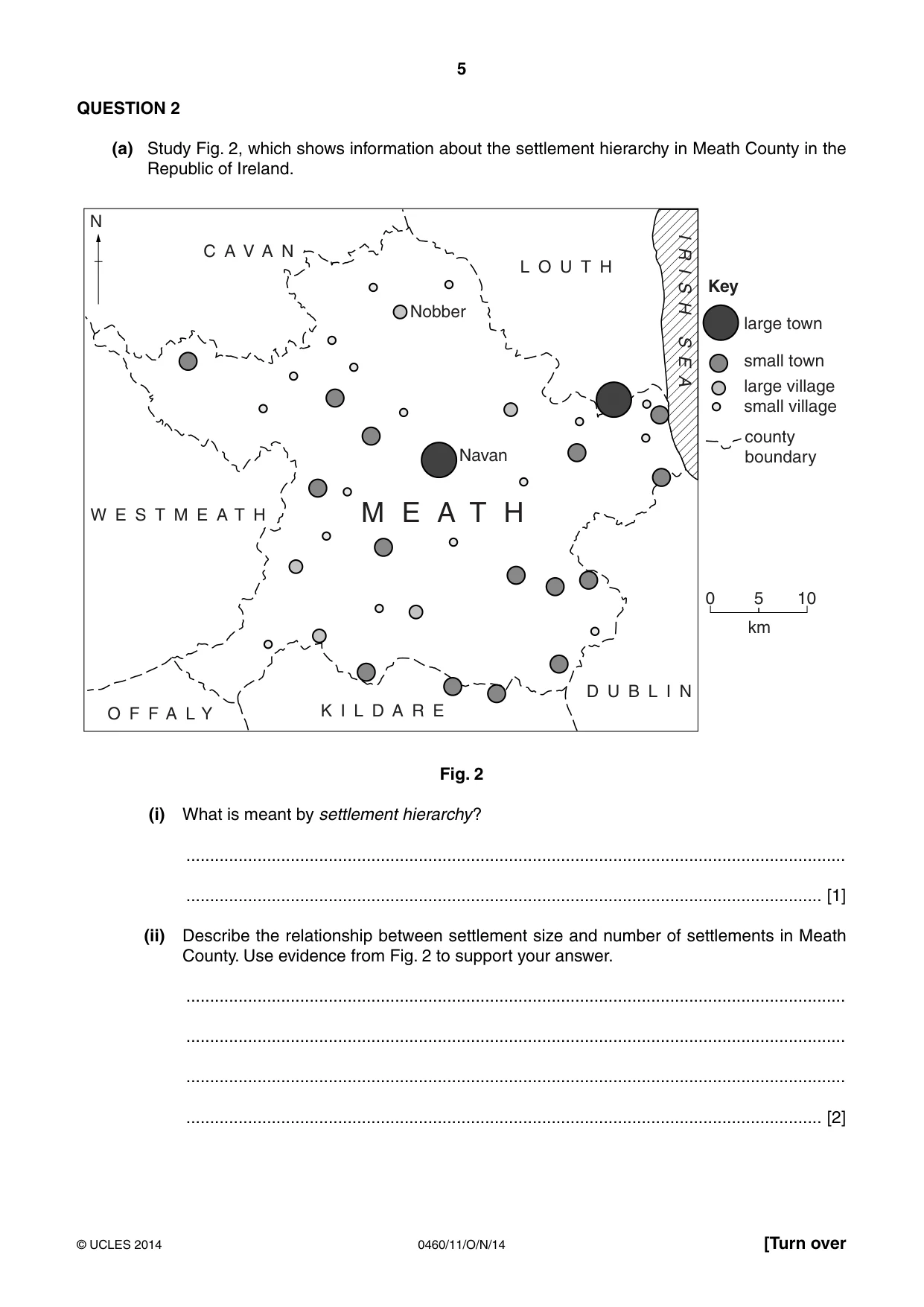
5 0460/11/O/N/14 © UCLES 2014 [Turn over QUESTION 2 (a) Study Fig. 2, which shows information about the settlement hierarchy in Meath County in the Republic of Ireland. M E A T H L O U T H C A V A N W E S T M E A T H O F F A L Y K I L D A R E D U B L I N I R I S H S E A Nobber Navan large town small town county boundary small village large village 0 5 10 Key N km Fig. 2 (i) What is meant by settlement hierarchy? … … [1] (ii) Describe the relationship between settlement size and number of settlements in Meath County. Use evidence from Fig. 2 to support your answer. … … … … [2]
Question paper, page 6
6 0460/11/O/N/14 © UCLES 2014 (iii) Describe three likely differences between the services in Navan and Nobber. 1 … … 2 … … 3 … … [3] (iv) Dublin is the capital city of the Republic of Ireland. Suggest reasons why many people who live in Meath County will travel regularly to Dublin, even though it is 50 kilometres away. … … … … … … … … [4]
Question paper, page 7
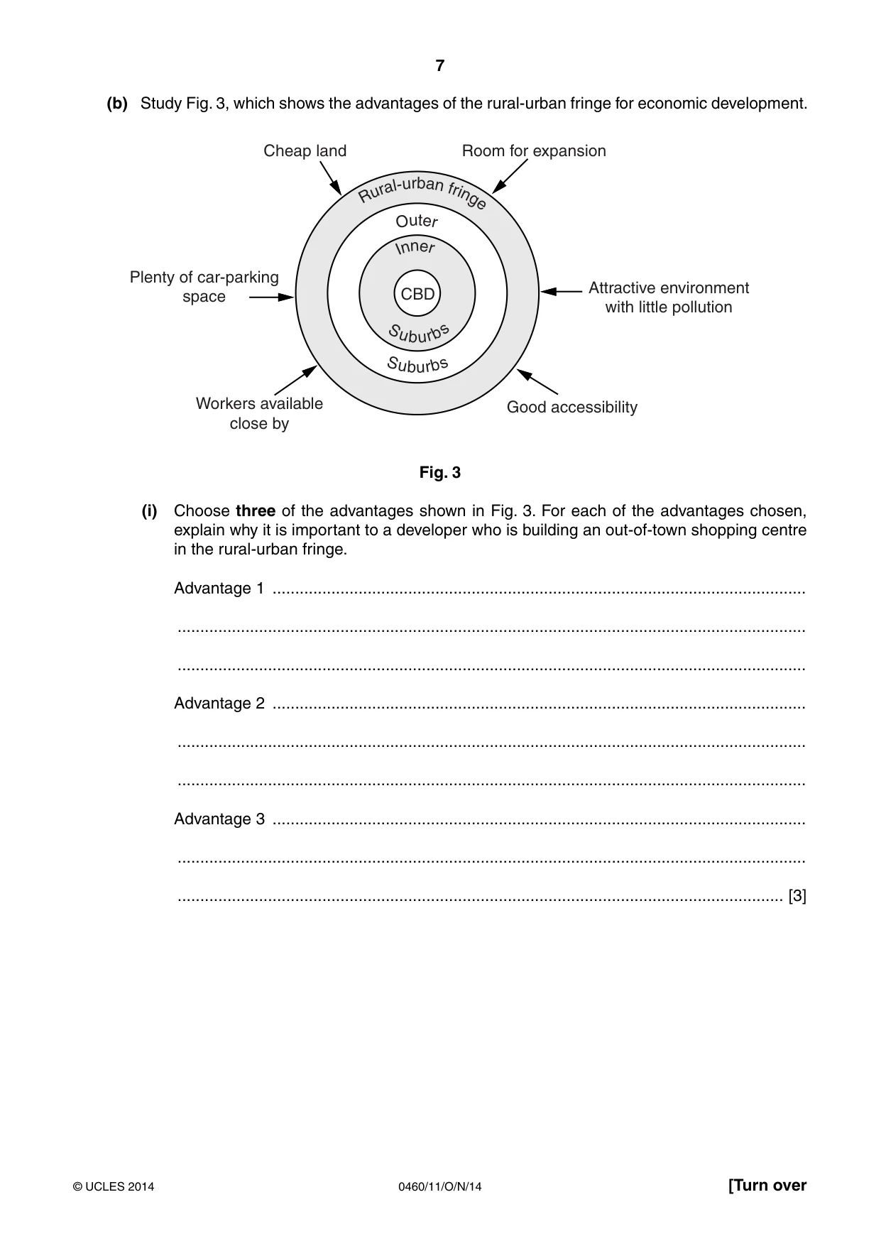
7 0460/11/O/N/14 © UCLES 2014 [Turn over (b) Study Fig. 3, which shows the advantages of the rural-urban fringe for economic development. S u b u r b s O u t e r S u b u r b s I n n e r R u r a l- u r b a n f ri n g e CBD Cheap land Room for expansion Good accessibility Workers available close by Attractive environment with little pollution Plenty of car-parking space Fig. 3 (i) Choose three of the advantages shown in Fig. 3. For each of the advantages chosen, explain why it is important to a developer who is building an out-of-town shopping centre in the rural-urban fringe. Advantage 1 … … … Advantage 2 … … … Advantage 3 … … … [3]
Question paper, page 8
8 0460/11/O/N/14 © UCLES 2014 (ii) Explain the likely impacts of a new out-of-town shopping centre on services in other parts of the urban area. … … … … … … … … … … [5]
Question paper, page 9
9 0460/11/O/N/14 © UCLES 2014 [Turn over (c) For a named example you have studied of a town or city in an MEDC, describe the environmental problems which have occurred in the rural-urban fringe as a result of urban sprawl. Name of city … … … … … … … … … … … … … … … [7] [Total: 25 marks] END OF QUESTION 2
Question paper, page 10
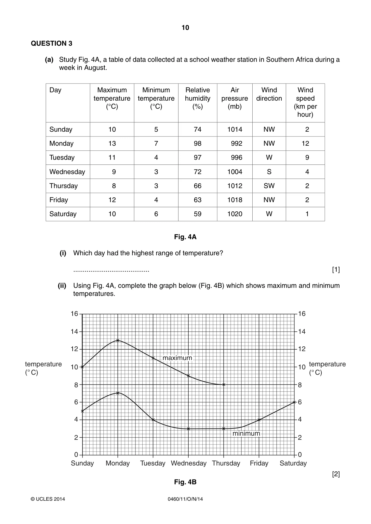
10 0460/11/O/N/14 © UCLES 2014 QUESTION 3 (a) Study Fig. 4A, a table of data collected at a school weather station in Southern Africa during a week in August. Day Maximum temperature (°C) Minimum temperature (°C) Relative humidity (%) Air pressure (mb) Wind direction Wind speed (km per hour) Sunday 10 5 74 1014 NW 2 Monday 13 7 98 992 NW 12 Tuesday 11 4 97 996 W 9 Wednesday 9 3 72 1004 S 4 Thursday 8 3 66 1012 SW 2 Friday 12 4 63 1018 NW 2 Saturday 10 6 59 1020 W 1 Fig. 4A (i) Which day had the highest range of temperature? … [1] (ii) Using Fig. 4A, complete the graph below (Fig. 4B) which shows maximum and minimum temperatures. 16 14 12 10 8 6 4 2 0 16 14 12 10 8 6 4 2 0 Sunday Monday Tuesday Thursday Friday Saturday Wednesday temperature (° C) temperature (° C) maximum minimum [2] Fig. 4B
Question paper, page 11
11 0460/11/O/N/14 © UCLES 2014 [Turn over (iii) Identify the weather characteristic shown in Fig. 4A which is measured by each of the following instruments: Wind vane … Barometer … Wet and dry bulb thermometer (hygrometer) … [3] (iv) Describe how information about the amount of precipitation (rainfall) can be collected. … … … … … … … … [4]
Question paper, page 12
12 0460/11/O/N/14 © UCLES 2014 (b) Study Photographs D and E (Insert), which show different types of cloud. (i) Describe three differences between the clouds shown in Photographs D and E. 1 … … 2 … … 3 … … [3] (ii) Explain why more cloud forms in tropical rainforest areas than in tropical deserts. … … … … … … … … … … [5]
Question paper, page 13
13 0460/11/O/N/14 © UCLES 2014 [Turn over (c) For a named country or area where drought occurs, describe its impacts on people and the natural environment. Country or area … … … … … … … … … … … … … … … [7] [Total: 25 marks] END OF QUESTION 3
Question paper, page 14
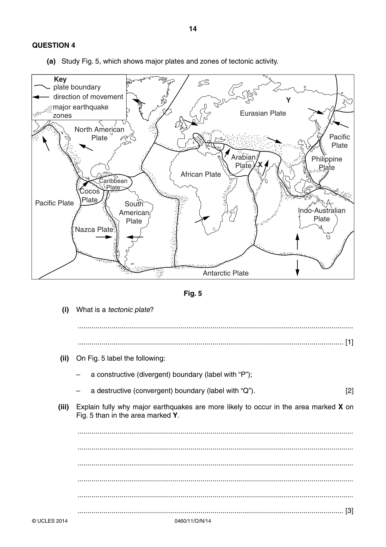
14 0460/11/O/N/14 © UCLES 2014 QUESTION 4 (a) Study Fig. 5, which shows major plates and zones of tectonic activity. plate boundary direction of movement Key major earthquake zones African Plate Arabian Plate Eurasian Plate Pacific Plate Philippine Plate Indo-Australian Plate Antarctic Plate South American Plate X Y Nazca Plate Pacific Plate North American Plate Cocos Plate Caribbean Plate Fig. 5 (i) What is a tectonic plate? … … [1] (ii) On Fig. 5 label the following: – a constructive (divergent) boundary (label with “P”); – a destructive (convergent) boundary (label with “Q”). [2] (iii) Explain fully why major earthquakes are more likely to occur in the area marked X on Fig. 5 than in the area marked Y. … … … … … … [3]
Question paper, page 15
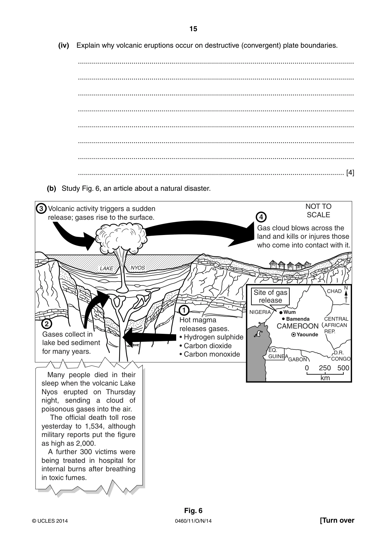
15 0460/11/O/N/14 © UCLES 2014 [Turn over (iv) Explain why volcanic eruptions occur on destructive (convergent) plate boundaries. … … … … … … … … [4] (b) Study Fig. 6, an article about a natural disaster. CAMEROON Volcanic activity triggers a sudden release; gases rise to the surface. Gas cloud blows across the land and kills or injures those who come into contact with it. Hot magma releases gases. s(YDROGENSULPHIDE s#ARBONDIOXIDE s#ARBONMONOXIDE NIGERIA CHAD CENTRAL AFRICAN REP. D.R. CONGO EQ. GUINEAGABON Yaounde Bamenda Wum N Gases collect in lake bed sediment for many years. LAKE NYOS Site of gas release 1 2 3 4 0 250 500 km -ANY PEOPLE DIED IN THEIRSLEEPWHENTHEVOLCANIC,AKE.YOS ERUPTED ON 4HURSDAYnight, sending a cloud of POISONOUSGASESINTOTHEAIR The official death toll rose yesterday to 1,534, although MILITARYREPORTSPUTTHEFIGUREas high as 2,000. A further 300 victims were BEING TREATED IN HOSPITAL FORinternal burns after breathing INTOXICFUMES NOT TO SCALE Fig. 6
Question paper, page 16
16 0460/11/O/N/14 © UCLES 2014 (i) Describe the processes which caused the disaster shown in Fig. 6. … … … … … … [3] (ii) Explain why people continue to live in areas of volcanic activity. … … … … … … … … … … [5]
Question paper, page 17
17 0460/11/O/N/14 © UCLES 2014 [Turn over (c) Describe the impacts of an earthquake on an area you have studied. Area where earthquake occurred … … … … … … … … … … … … … … … [7] [Total: 25 marks] END OF QUESTION 4
Question paper, page 18
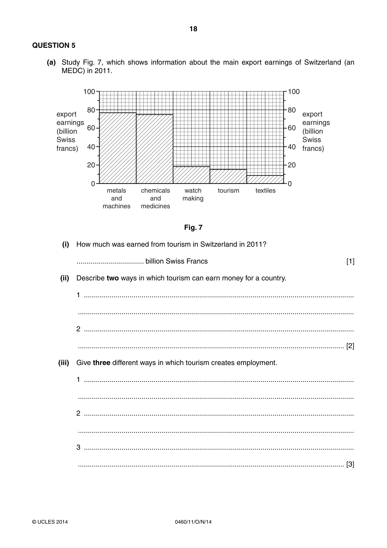
18 0460/11/O/N/14 © UCLES 2014 QUESTION 5 (a) Study Fig. 7, which shows information about the main export earnings of Switzerland (an MEDC) in 2011. 20 0 40 60 80 100 20 0 40 60 80 100 export earnings (billion Swiss francs) export earnings (billion Swiss francs) metals and machines chemicals and medicines watch making tourism textiles Fig. 7 (i) How much was earned from tourism in Switzerland in 2011? … billion Swiss Francs [1] (ii) Describe two ways in which tourism can earn money for a country. 1 … … 2 … … [2] (iii) Give three different ways in which tourism creates employment. 1 … … 2 … … 3 … … [3]
Question paper, page 19
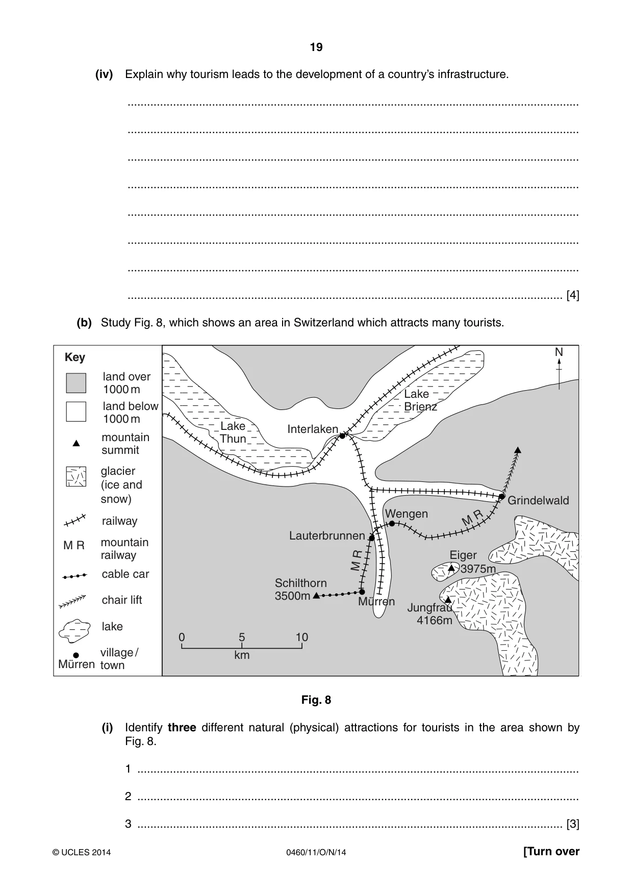
19 0460/11/O/N/14 © UCLES 2014 [Turn over (iv) Explain why tourism leads to the development of a country’s infrastructure. … … … … … … … … [4] (b) Study Fig. 8, which shows an area in Switzerland which attracts many tourists. km 0 5 10 Lake Thun Lake Brienz Grindelwald Eiger Jungfrau 4166m 3975m Lauterbrunnen Schilthorn 3500m Mürren Wengen M R M R Interlaken land below 1000 m land over 1000 m mountain summit glacier (ice and snow) mountain railway railway cable car chair lift lake N Key M R Mürren village / town Fig. 8 (i) Identify three different natural (physical) attractions for tourists in the area shown by Fig. 8. 1 … 2 … 3 … [3]
Question paper, page 20
20 0460/11/O/N/14 © UCLES 2014 (ii) Suggest how tourism can cause problems for residents of towns like Interlaken. … … … … … … … … … … [5] (c) For a named country or area you have studied, describe the impacts of tourism on the natural environment. Name of area or country … … … … … … … … … … … … … … … [7] [Total: 25 marks] END OF QUESTION 5
Question paper, page 21
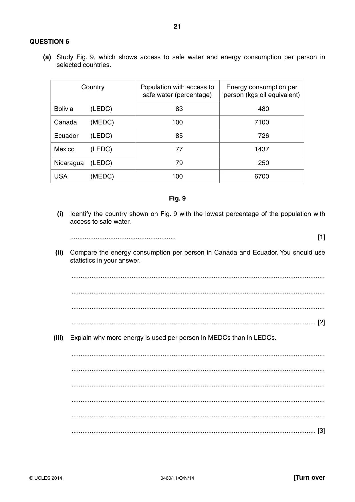
21 0460/11/O/N/14 © UCLES 2014 [Turn over QUESTION 6 (a) Study Fig. 9, which shows access to safe water and energy consumption per person in selected countries. Country Population with access to safe water (percentage) Energy consumption per person (kgs oil equivalent) Bolivia (LEDC) 83 480 Canada (MEDC) 100 7100 Ecuador (LEDC) 85 726 Mexico (LEDC) 77 1437 Nicaragua (LEDC) 79 250 USA (MEDC) 100 6700 Fig. 9 (i) Identify the country shown on Fig. 9 with the lowest percentage of the population with access to safe water. … [1] (ii) Compare the energy consumption per person in Canada and Ecuador. You should use statistics in your answer. … … … … [2] (iii) Explain why more energy is used per person in MEDCs than in LEDCs. … … … … … … [3]
Question paper, page 22
22 0460/11/O/N/14 © UCLES 2014 (iv) Suggest reasons why it is important for LEDCs to improve water supplies. … … … … … … … … [4]
Question paper, page 23
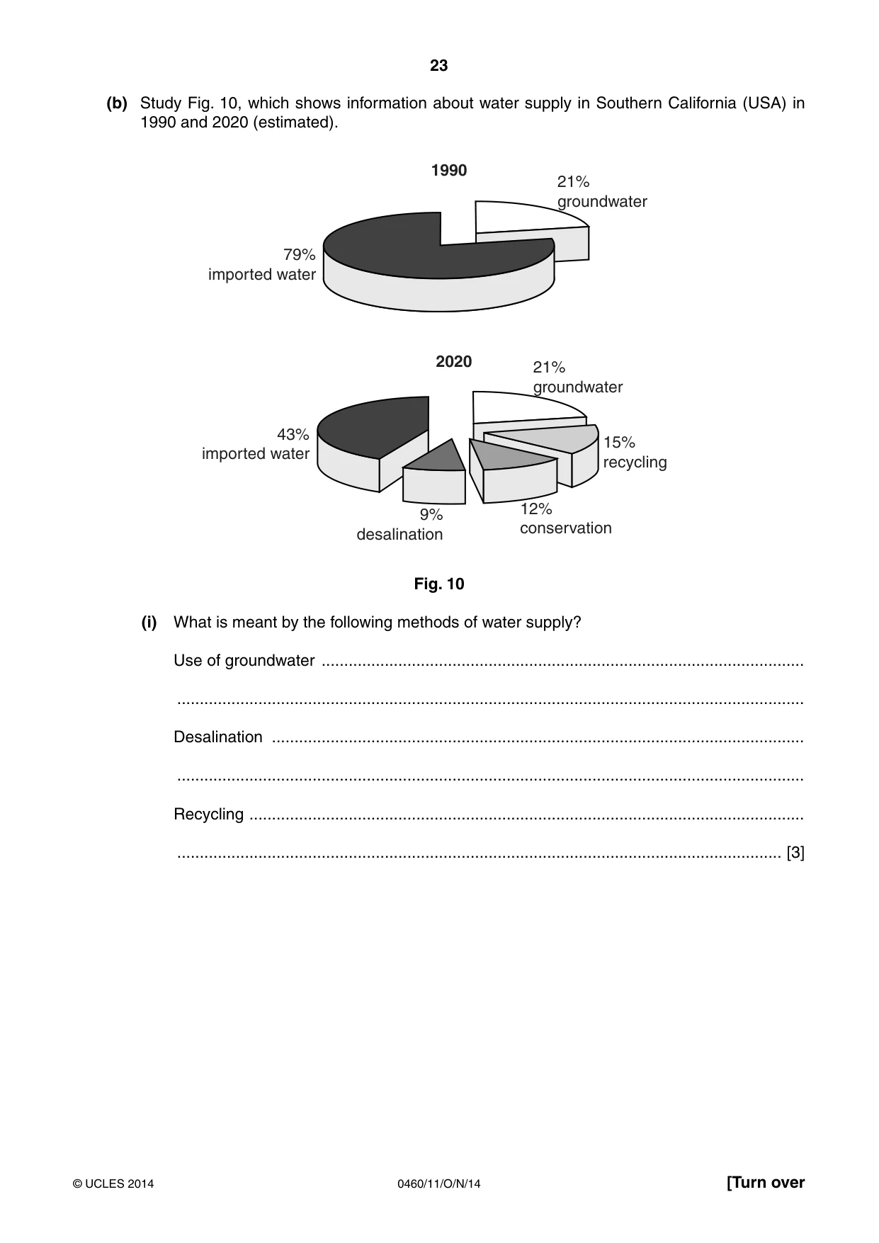
23 0460/11/O/N/14 © UCLES 2014 [Turn over (b) Study Fig. 10, which shows information about water supply in Southern California (USA) in 1990 and 2020 (estimated). 79% imported water 43% imported water 9% desalination 21% groundwater 12% conservation 15% recycling 21% groundwater 2020 1990 Fig. 10 (i) What is meant by the following methods of water supply? Use of groundwater … … Desalination … … Recycling … … [3]
Question paper, page 24
24 0460/11/O/N/14 © UCLES 2014 (ii) The conservation of water is becoming increasingly important. Describe methods which can be used to conserve water. … … … … … … … … … … [5]
Question paper, page 25
25 0460/11/O/N/14 © UCLES 2014 [Turn over (c) For a named area or country you have studied, describe how it obtains its energy. Name of area or country … … … … … … … … … … … … … … … [7] [Total: 25 marks] END OF QUESTION 6
Question paper, page 26
26 0460/11/O/N/14 © UCLES 2014 Additional Page If you use the following lined page to complete the answer(s) to any question(s), the question number(s) must be clearly shown. … … … … … … … … … … … … … … … … … … … … … … … … … …
Question paper, page 27
27 0460/11/O/N/14 © UCLES 2014 BLANK PAGE
Question paper, page 28
28 0460/11/O/N/14 © UCLES 2014 Copyright Acknowledgements: Question 1 Fig. 1B © http://sgrhs.unisa.edu.au/student/prep_rural_prac/1-major_issues.htm Question 1 Photographs A–C S. Sibley © UCLES. Question 2 Fig. 2 http://www.meath.ie/CountyCouncil/Publications/PlanningandDevelopmentPublications/CountyMeathDevelopmentPlan2007- 2013-Adopted/ Question 2 Fig. 3 http://igeogers.weebly.com/changing-hic-cities.html Question 3 Photographs D–E S. Sibley © UCLES. Question 6 Fig. 10 http://www.westbasin.org/water-reliability-2020/planning/water-reliability Permission to reproduce items where third-party owned material protected by copyright is included has been sought and cleared where possible. Every reasonable effort has been made by the publisher (UCLES) to trace copyright holders, but if any items requiring clearance have unwittingly been included, the publisher will be pleased to make amends at the earliest possible opportunity. Cambridge International Examinations is part of the Cambridge Assessment Group. Cambridge Assessment is the brand name of University of Cambridge Local Examinations Syndicate (UCLES), which is itself a department of the University of Cambridge. BLANK PAGE
Mark scheme, page 1
® IGCSE is the registered trademark of Cambridge International Examinations. CAMBRIDGE INTERNATIONAL EXAMINATIONS Cambridge International General Certificate of Secondary Education MARK SCHEME for the October/November 2014 series 0460 GEOGRAPHY 0460/11 Paper 1, maximum raw mark 75 This mark scheme is published as an aid to teachers and candidates, to indicate the requirements of the examination. It shows the basis on which Examiners were instructed to award marks. It does not indicate the details of the discussions that took place at an Examiners’ meeting before marking began, which would have considered the acceptability of alternative answers. Mark schemes should be read in conjunction with the question paper and the Principal Examiner Report for Teachers. Cambridge will not enter into discussions about these mark schemes. Cambridge is publishing the mark schemes for the October/November 2014 series for most Cambridge IGCSE®, Cambridge International A and AS Level components and some Cambridge O Level components.
Mark scheme, page 2
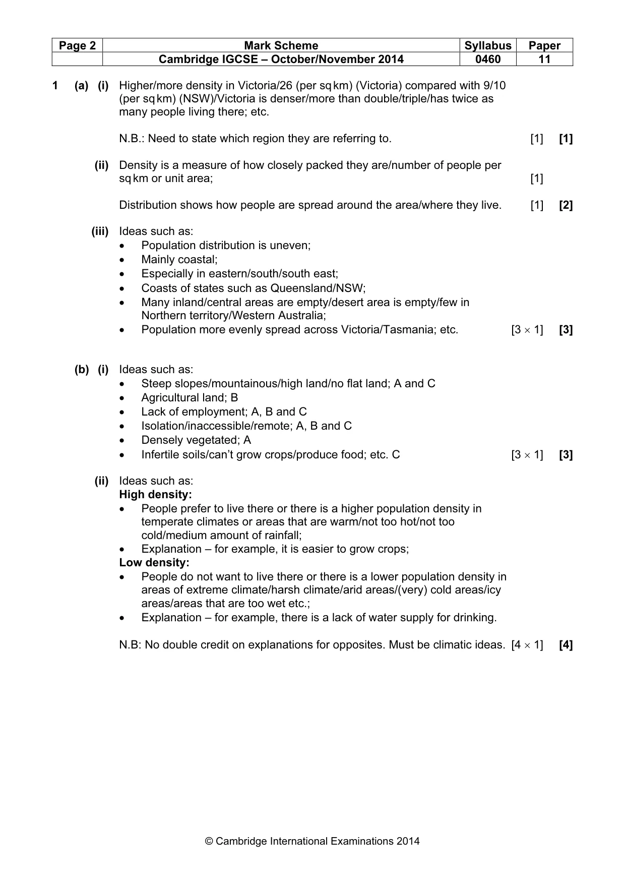
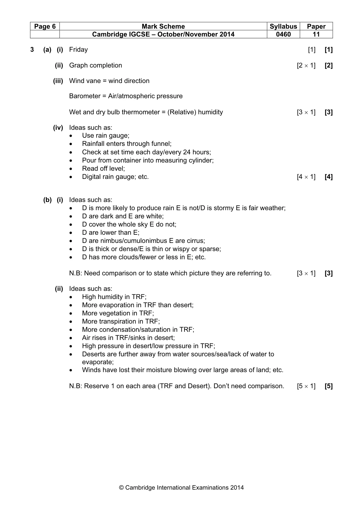
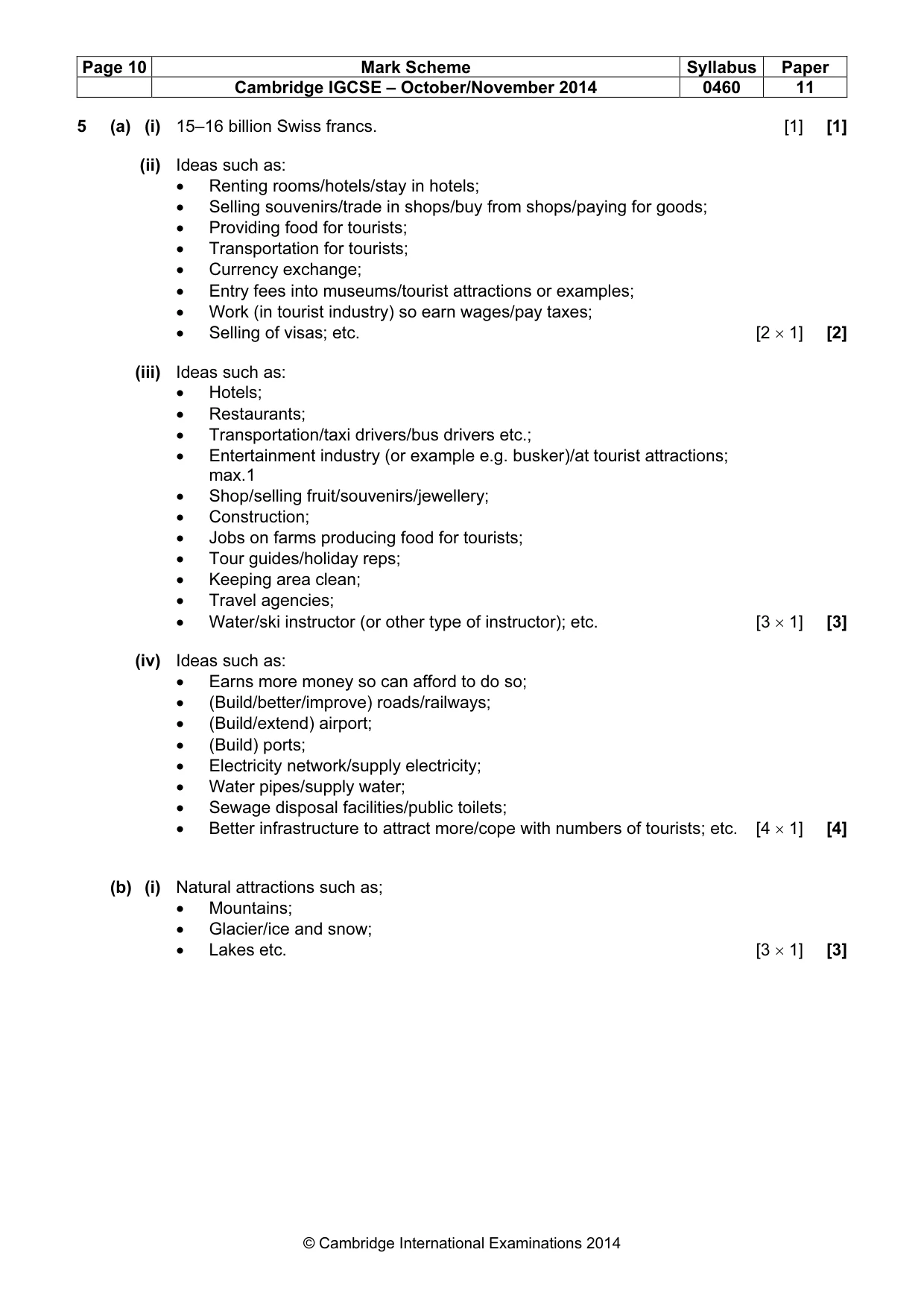
Page 2 Mark Scheme Syllabus Paper Cambridge IGCSE – October/November 2014 0460 11 © Cambridge International Examinations 2014 1 (a) (i) Higher/more density in Victoria/26 (per sq km) (Victoria) compared with 9/10 (per sq km) (NSW)/Victoria is denser/more than double/triple/has twice as many people living there; etc. N.B.: Need to state which region they are referring to. [1] [1] (ii) Density is a measure of how closely packed they are/number of people per sq km or unit area; [1] Distribution shows how people are spread around the area/where they live. [1] [2] (iii) Ideas such as: • Population distribution is uneven; • Mainly coastal; • Especially in eastern/south/south east; • Coasts of states such as Queensland/NSW; • Many inland/central areas are empty/desert area is empty/few in Northern territory/Western Australia; • Population more evenly spread across Victoria/Tasmania; etc. [3 × 1] [3] (b) (i) Ideas such as: • Steep slopes/mountainous/high land/no flat land; A and C • Agricultural land; B • Lack of employment; A, B and C • Isolation/inaccessible/remote; A, B and C • Densely vegetated; A • Infertile soils/can’t grow crops/produce food; etc. C [3 × 1] [3] (ii) Ideas such as: High density: • People prefer to live there or there is a higher population density in temperate climates or areas that are warm/not too hot/not too cold/medium amount of rainfall; • Explanation – for example, it is easier to grow crops; Low density: • People do not want to live there or there is a lower population density in areas of extreme climate/harsh climate/arid areas/(very) cold areas/icy areas/areas that are too wet etc.; • Explanation – for example, there is a lack of water supply for drinking. N.B: No double credit on explanations for opposites. Must be climatic ideas. [4 × 1] [4]
Mark scheme, page 3
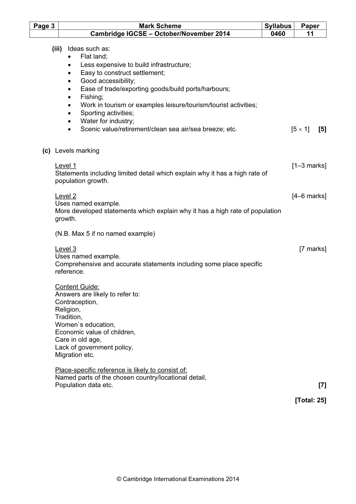
Page 3 Mark Scheme Syllabus Paper Cambridge IGCSE – October/November 2014 0460 11 © Cambridge International Examinations 2014 (iii) Ideas such as: • Flat land; • Less expensive to build infrastructure; • Easy to construct settlement; • Good accessibility; • Ease of trade/exporting goods/build ports/harbours; • Fishing; • Work in tourism or examples leisure/tourism/tourist activities; • Sporting activities; • Water for industry; • Scenic value/retirement/clean sea air/sea breeze; etc. [5 × 1] [5] (c) Levels marking Level 1 [1–3 marks] Statements including limited detail which explain why it has a high rate of population growth. Level 2 [4–6 marks] Uses named example. More developed statements which explain why it has a high rate of population growth. (N.B. Max 5 if no named example) Level 3 [7 marks] Uses named example. Comprehensive and accurate statements including some place specific reference. Content Guide: Answers are likely to refer to: Contraception, Religion, Tradition, Women`s education, Economic value of children, Care in old age, Lack of government policy, Migration etc. Place-specific reference is likely to consist of: Named parts of the chosen country/locational detail, Population data etc. [7] [Total: 25]
Mark scheme, page 4
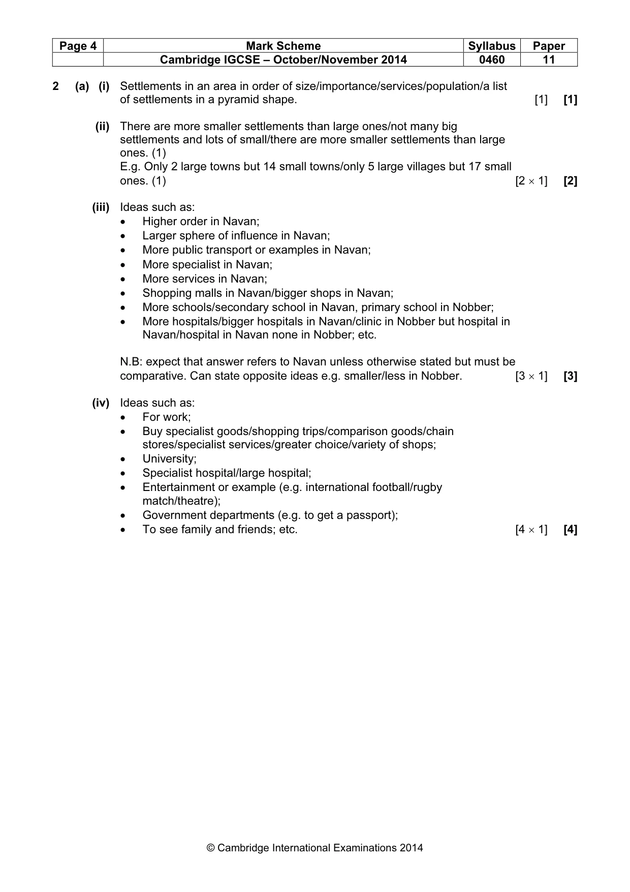
Page 4 Mark Scheme Syllabus Paper Cambridge IGCSE – October/November 2014 0460 11 © Cambridge International Examinations 2014 2 (a) (i) Settlements in an area in order of size/importance/services/population/a list of settlements in a pyramid shape. [1] [1] (ii) There are more smaller settlements than large ones/not many big settlements and lots of small/there are more smaller settlements than large ones. (1) E.g. Only 2 large towns but 14 small towns/only 5 large villages but 17 small ones. (1) [2 × 1] [2] (iii) Ideas such as: • Higher order in Navan; • Larger sphere of influence in Navan; • More public transport or examples in Navan; • More specialist in Navan; • More services in Navan; • Shopping malls in Navan/bigger shops in Navan; • More schools/secondary school in Navan, primary school in Nobber; • More hospitals/bigger hospitals in Navan/clinic in Nobber but hospital in Navan/hospital in Navan none in Nobber; etc. N.B: expect that answer refers to Navan unless otherwise stated but must be comparative. Can state opposite ideas e.g. smaller/less in Nobber. [3 × 1] [3] (iv) Ideas such as: • For work; • Buy specialist goods/shopping trips/comparison goods/chain stores/specialist services/greater choice/variety of shops; • University; • Specialist hospital/large hospital; • Entertainment or example (e.g. international football/rugby match/theatre); • Government departments (e.g. to get a passport); • To see family and friends; etc. [4 × 1] [4]
Mark scheme, page 5
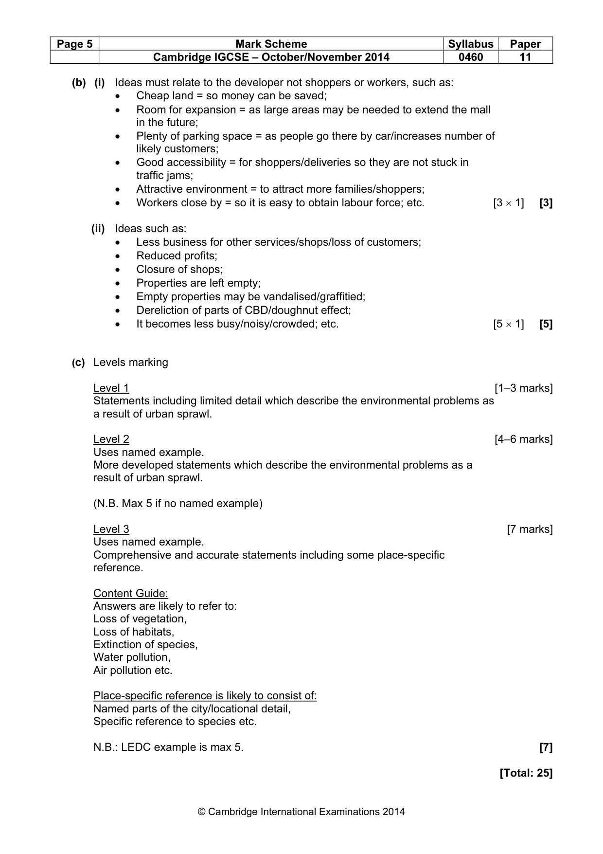
Page 5 Mark Scheme Syllabus Paper Cambridge IGCSE – October/November 2014 0460 11 © Cambridge International Examinations 2014 (b) (i) Ideas must relate to the developer not shoppers or workers, such as: • Cheap land = so money can be saved; • Room for expansion = as large areas may be needed to extend the mall in the future; • Plenty of parking space = as people go there by car/increases number of likely customers; • Good accessibility = for shoppers/deliveries so they are not stuck in traffic jams; • Attractive environment = to attract more families/shoppers; • Workers close by = so it is easy to obtain labour force; etc. [3 × 1] [3] (ii) Ideas such as: • Less business for other services/shops/loss of customers; • Reduced profits; • Closure of shops; • Properties are left empty; • Empty properties may be vandalised/graffitied; • Dereliction of parts of CBD/doughnut effect; • It becomes less busy/noisy/crowded; etc. [5 × 1] [5] (c) Levels marking Level 1 [1–3 marks] Statements including limited detail which describe the environmental problems as a result of urban sprawl. Level 2 [4–6 marks] Uses named example. More developed statements which describe the environmental problems as a result of urban sprawl. (N.B. Max 5 if no named example) Level 3 [7 marks] Uses named example. Comprehensive and accurate statements including some place-specific reference. Content Guide: Answers are likely to refer to: Loss of vegetation, Loss of habitats, Extinction of species, Water pollution, Air pollution etc. Place-specific reference is likely to consist of: Named parts of the city/locational detail, Specific reference to species etc. N.B.: LEDC example is max 5. [7] [Total: 25]
Mark scheme, page 6
Page 6 Mark Scheme Syllabus Paper Cambridge IGCSE – October/November 2014 0460 11 © Cambridge International Examinations 2014 3 (a) (i) Friday [1] [1] (ii) Graph completion [2 × 1] [2] (iii) Wind vane = wind direction Barometer = Air/atmospheric pressure Wet and dry bulb thermometer = (Relative) humidity [3 × 1] [3] (iv) Ideas such as: • Use rain gauge; • Rainfall enters through funnel; • Check at set time each day/every 24 hours; • Pour from container into measuring cylinder; • Read off level; • Digital rain gauge; etc. [4 × 1] [4] (b) (i) Ideas such as: • D is more likely to produce rain E is not/D is stormy E is fair weather; • D are dark and E are white; • D cover the whole sky E do not; • D are lower than E; • D are nimbus/cumulonimbus E are cirrus; • D is thick or dense/E is thin or wispy or sparse; • D has more clouds/fewer or less in E; etc. N.B: Need comparison or to state which picture they are referring to. [3 × 1] [3] (ii) Ideas such as: • High humidity in TRF; • More evaporation in TRF than desert; • More vegetation in TRF; • More transpiration in TRF; • More condensation/saturation in TRF; • Air rises in TRF/sinks in desert; • High pressure in desert/low pressure in TRF; • Deserts are further away from water sources/sea/lack of water to evaporate; • Winds have lost their moisture blowing over large areas of land; etc. N.B: Reserve 1 on each area (TRF and Desert). Don’t need comparison. [5 × 1] [5]
Mark scheme, page 7
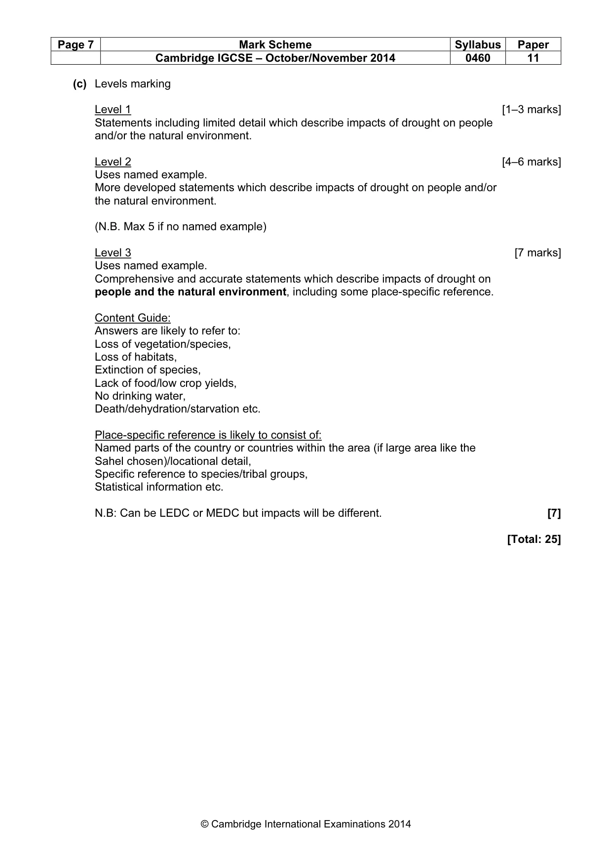
Page 7 Mark Scheme Syllabus Paper Cambridge IGCSE – October/November 2014 0460 11 © Cambridge International Examinations 2014 (c) Levels marking Level 1 [1–3 marks] Statements including limited detail which describe impacts of drought on people and/or the natural environment. Level 2 [4–6 marks] Uses named example. More developed statements which describe impacts of drought on people and/or the natural environment. (N.B. Max 5 if no named example) Level 3 [7 marks] Uses named example. Comprehensive and accurate statements which describe impacts of drought on people and the natural environment, including some place-specific reference. Content Guide: Answers are likely to refer to: Loss of vegetation/species, Loss of habitats, Extinction of species, Lack of food/low crop yields, No drinking water, Death/dehydration/starvation etc. Place-specific reference is likely to consist of: Named parts of the country or countries within the area (if large area like the Sahel chosen)/locational detail, Specific reference to species/tribal groups, Statistical information etc. N.B: Can be LEDC or MEDC but impacts will be different. [7] [Total: 25]
Mark scheme, page 8
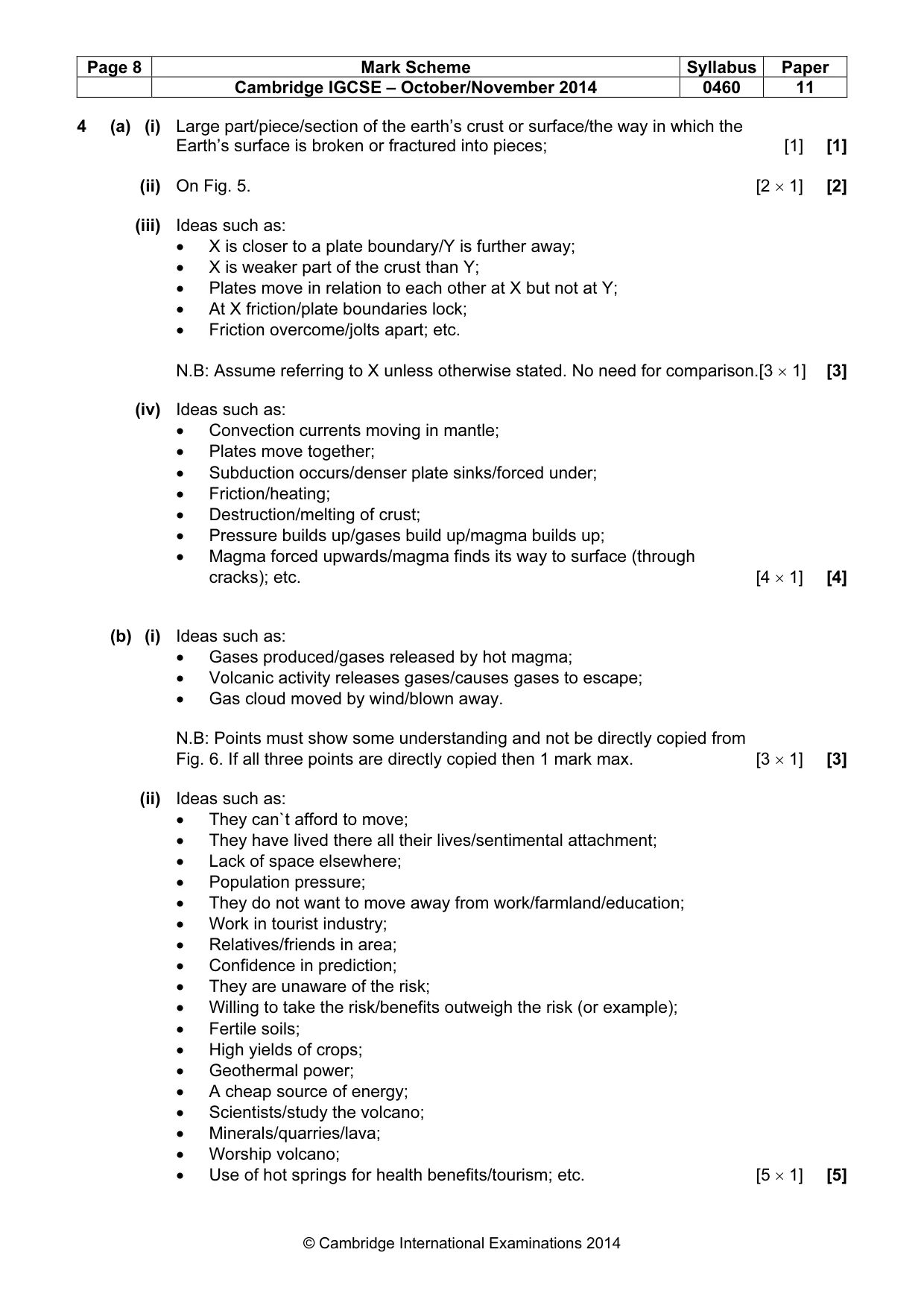
Page 8 Mark Scheme Syllabus Paper Cambridge IGCSE – October/November 2014 0460 11 © Cambridge International Examinations 2014 4 (a) (i) Large part/piece/section of the earth’s crust or surface/the way in which the Earth’s surface is broken or fractured into pieces; [1] [1] (ii) On Fig. 5. [2 × 1] [2] (iii) Ideas such as: • X is closer to a plate boundary/Y is further away; • X is weaker part of the crust than Y; • Plates move in relation to each other at X but not at Y; • At X friction/plate boundaries lock; • Friction overcome/jolts apart; etc. N.B: Assume referring to X unless otherwise stated. No need for comparison.[3 × 1] [3] (iv) Ideas such as: • Convection currents moving in mantle; • Plates move together; • Subduction occurs/denser plate sinks/forced under; • Friction/heating; • Destruction/melting of crust; • Pressure builds up/gases build up/magma builds up; • Magma forced upwards/magma finds its way to surface (through cracks); etc. [4 × 1] [4] (b) (i) Ideas such as: • Gases produced/gases released by hot magma; • Volcanic activity releases gases/causes gases to escape; • Gas cloud moved by wind/blown away. N.B: Points must show some understanding and not be directly copied from Fig. 6. If all three points are directly copied then 1 mark max. [3 × 1] [3] (ii) Ideas such as: • They can`t afford to move; • They have lived there all their lives/sentimental attachment; • Lack of space elsewhere; • Population pressure; • They do not want to move away from work/farmland/education; • Work in tourist industry; • Relatives/friends in area; • Confidence in prediction; • They are unaware of the risk; • Willing to take the risk/benefits outweigh the risk (or example); • Fertile soils; • High yields of crops; • Geothermal power; • A cheap source of energy; • Scientists/study the volcano; • Minerals/quarries/lava; • Worship volcano; • Use of hot springs for health benefits/tourism; etc. [5 × 1] [5]
Mark scheme, page 9
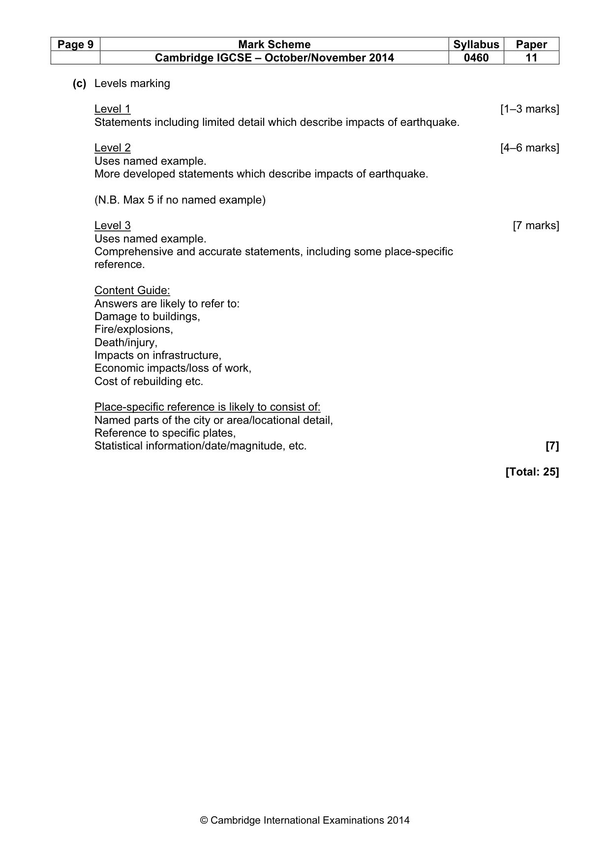
Page 9 Mark Scheme Syllabus Paper Cambridge IGCSE – October/November 2014 0460 11 © Cambridge International Examinations 2014 (c) Levels marking Level 1 [1–3 marks] Statements including limited detail which describe impacts of earthquake. Level 2 [4–6 marks] Uses named example. More developed statements which describe impacts of earthquake. (N.B. Max 5 if no named example) Level 3 [7 marks] Uses named example. Comprehensive and accurate statements, including some place-specific reference. Content Guide: Answers are likely to refer to: Damage to buildings, Fire/explosions, Death/injury, Impacts on infrastructure, Economic impacts/loss of work, Cost of rebuilding etc. Place-specific reference is likely to consist of: Named parts of the city or area/locational detail, Reference to specific plates, Statistical information/date/magnitude, etc. [7] [Total: 25]
Mark scheme, page 10
Page 10 Mark Scheme Syllabus Paper Cambridge IGCSE – October/November 2014 0460 11 © Cambridge International Examinations 2014 5 (a) (i) 15–16 billion Swiss francs. [1] [1] (ii) Ideas such as: • Renting rooms/hotels/stay in hotels; • Selling souvenirs/trade in shops/buy from shops/paying for goods; • Providing food for tourists; • Transportation for tourists; • Currency exchange; • Entry fees into museums/tourist attractions or examples; • Work (in tourist industry) so earn wages/pay taxes; • Selling of visas; etc. [2 × 1] [2] (iii) Ideas such as: • Hotels; • Restaurants; • Transportation/taxi drivers/bus drivers etc.; • Entertainment industry (or example e.g. busker)/at tourist attractions; max.1 • Shop/selling fruit/souvenirs/jewellery; • Construction; • Jobs on farms producing food for tourists; • Tour guides/holiday reps; • Keeping area clean; • Travel agencies; • Water/ski instructor (or other type of instructor); etc. [3 × 1] [3] (iv) Ideas such as: • Earns more money so can afford to do so; • (Build/better/improve) roads/railways; • (Build/extend) airport; • (Build) ports; • Electricity network/supply electricity; • Water pipes/supply water; • Sewage disposal facilities/public toilets; • Better infrastructure to attract more/cope with numbers of tourists; etc. [4 × 1] [4] (b) (i) Natural attractions such as; • Mountains; • Glacier/ice and snow; • Lakes etc. [3 × 1] [3]
Mark scheme, page 11
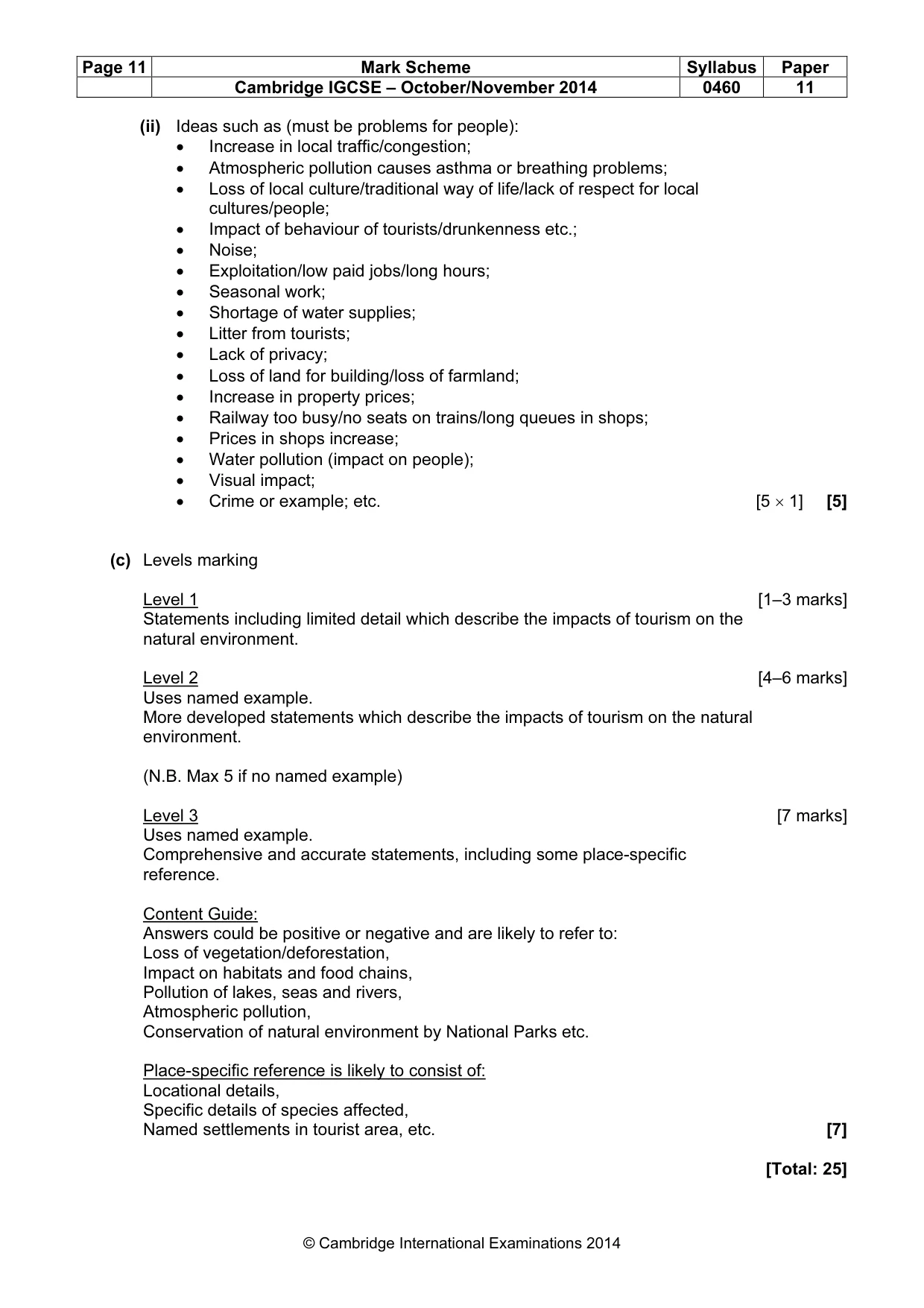
Page 11 Mark Scheme Syllabus Paper Cambridge IGCSE – October/November 2014 0460 11 © Cambridge International Examinations 2014 (ii) Ideas such as (must be problems for people): • Increase in local traffic/congestion; • Atmospheric pollution causes asthma or breathing problems; • Loss of local culture/traditional way of life/lack of respect for local cultures/people; • Impact of behaviour of tourists/drunkenness etc.; • Noise; • Exploitation/low paid jobs/long hours; • Seasonal work; • Shortage of water supplies; • Litter from tourists; • Lack of privacy; • Loss of land for building/loss of farmland; • Increase in property prices; • Railway too busy/no seats on trains/long queues in shops; • Prices in shops increase; • Water pollution (impact on people); • Visual impact; • Crime or example; etc. [5 × 1] [5] (c) Levels marking Level 1 [1–3 marks] Statements including limited detail which describe the impacts of tourism on the natural environment. Level 2 [4–6 marks] Uses named example. More developed statements which describe the impacts of tourism on the natural environment. (N.B. Max 5 if no named example) Level 3 [7 marks] Uses named example. Comprehensive and accurate statements, including some place-specific reference. Content Guide: Answers could be positive or negative and are likely to refer to: Loss of vegetation/deforestation, Impact on habitats and food chains, Pollution of lakes, seas and rivers, Atmospheric pollution, Conservation of natural environment by National Parks etc. Place-specific reference is likely to consist of: Locational details, Specific details of species affected, Named settlements in tourist area, etc. [7] [Total: 25]
Mark scheme, page 12
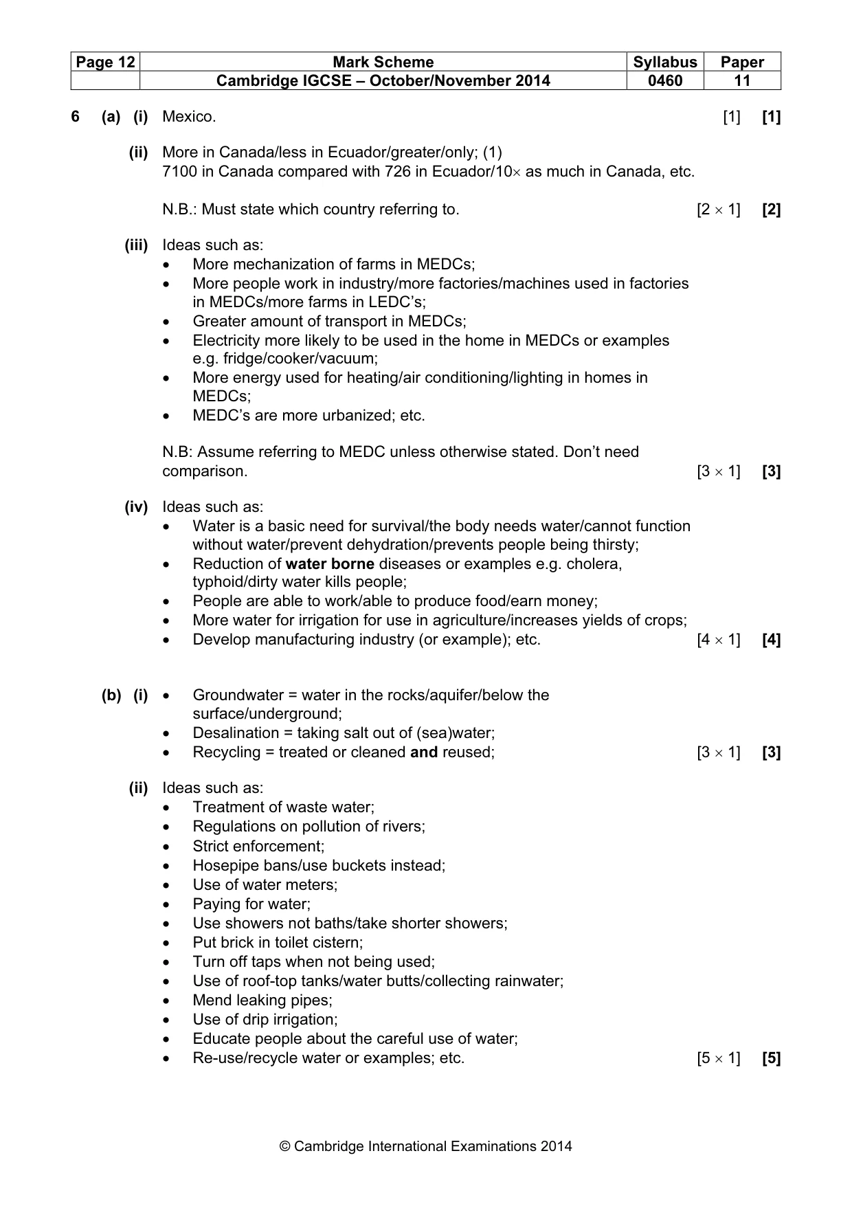
Page 12 Mark Scheme Syllabus Paper Cambridge IGCSE – October/November 2014 0460 11 © Cambridge International Examinations 2014 6 (a) (i) Mexico. [1] [1] (ii) More in Canada/less in Ecuador/greater/only; (1) 7100 in Canada compared with 726 in Ecuador/10× as much in Canada, etc. N.B.: Must state which country referring to. [2 × 1] [2] (iii) Ideas such as: • More mechanization of farms in MEDCs; • More people work in industry/more factories/machines used in factories in MEDCs/more farms in LEDC’s; • Greater amount of transport in MEDCs; • Electricity more likely to be used in the home in MEDCs or examples e.g. fridge/cooker/vacuum; • More energy used for heating/air conditioning/lighting in homes in MEDCs; • MEDC’s are more urbanized; etc. N.B: Assume referring to MEDC unless otherwise stated. Don’t need comparison. [3 × 1] [3] (iv) Ideas such as: • Water is a basic need for survival/the body needs water/cannot function without water/prevent dehydration/prevents people being thirsty; • Reduction of water borne diseases or examples e.g. cholera, typhoid/dirty water kills people; • People are able to work/able to produce food/earn money; • More water for irrigation for use in agriculture/increases yields of crops; • Develop manufacturing industry (or example); etc. [4 × 1] [4] (b) (i) • Groundwater = water in the rocks/aquifer/below the surface/underground; • Desalination = taking salt out of (sea)water; • Recycling = treated or cleaned and reused; [3 × 1] [3] (ii) Ideas such as: • Treatment of waste water; • Regulations on pollution of rivers; • Strict enforcement; • Hosepipe bans/use buckets instead; • Use of water meters; • Paying for water; • Use showers not baths/take shorter showers; • Put brick in toilet cistern; • Turn off taps when not being used; • Use of roof-top tanks/water butts/collecting rainwater; • Mend leaking pipes; • Use of drip irrigation; • Educate people about the careful use of water; • Re-use/recycle water or examples; etc. [5 × 1] [5]
Mark scheme, page 13
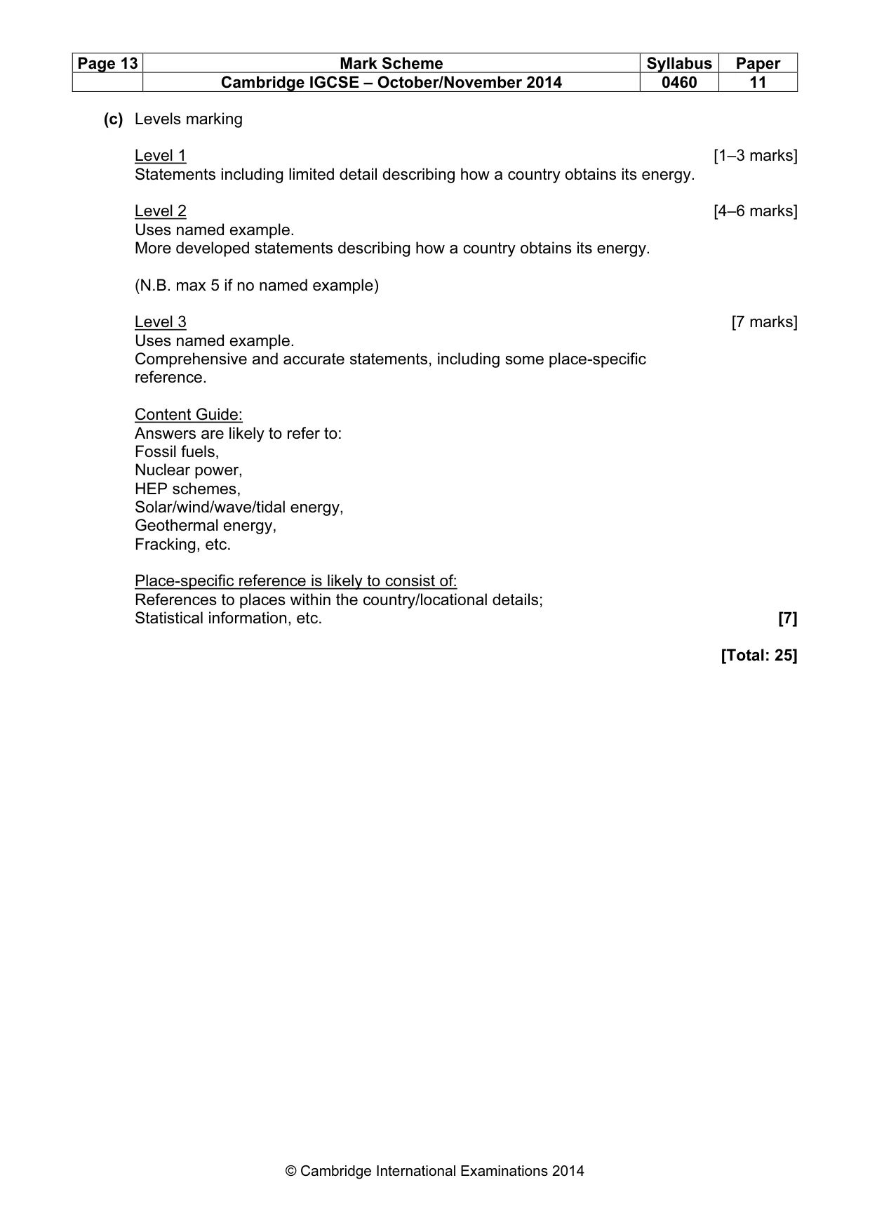
Page 13 Mark Scheme Syllabus Paper Cambridge IGCSE – October/November 2014 0460 11 © Cambridge International Examinations 2014 (c) Levels marking Level 1 [1–3 marks] Statements including limited detail describing how a country obtains its energy. Level 2 [4–6 marks] Uses named example. More developed statements describing how a country obtains its energy. (N.B. max 5 if no named example) Level 3 [7 marks] Uses named example. Comprehensive and accurate statements, including some place-specific reference. Content Guide: Answers are likely to refer to: Fossil fuels, Nuclear power, HEP schemes, Solar/wind/wave/tidal energy, Geothermal energy, Fracking, etc. Place-specific reference is likely to consist of: References to places within the country/locational details; Statistical information, etc. [7] [Total: 25]
What you needed in this session
Cambridge’s own grade thresholds for 2014 Oct/Nov, Paper 1 · Variant 1. A higher threshold means an easier paper — the bar moves with how the cohort did.