Cambridge IGCSE Geography 0460 — 2014 May/June Paper 1 · Variant 1
0460/11/M/J/14 · 75 marks · ≈84 min
The question paper and its mark scheme, free to read here and free to download. This is Cambridge’s own paper, exactly as it was sat.
Question paper28 pages


Mark scheme13 pages
Answers below. Sit the paper first if you are practising.
Paper as text
Question paper, page 1
This document consists of 25 printed pages, 3 blank pages and 1 Insert. DC (SJF/SW) 79527/7 © UCLES 2014 [Turn over Cambridge International Examinations Cambridge International General Certificate of Secondary Education * 0 8 5 6 8 9 1 3 9 8 * GEOGRAPHY 0460/11 Paper 1 May/June 2014 1 hour 45 minutes Candidates answer on the Question Paper. Additional Materials: Ruler Calculator READ THESE INSTRUCTIONS FIRST Write your Centre number, candidate number and name in the spaces provided. Write in dark blue or black pen. You may use an HB pencil for any diagrams or graphs. Do not use staples, paper clips, glue or correction fluid. DO NOT WRITE IN ANY BARCODES. Write your answer to each question in the space provided. If additional space is required, you should use the lined page at the end of this booklet. The question number(s) must be clearly shown. Answer three questions. The Insert contains Photograph A for Question 3, Photograph B for Question 4, and Photographs C, D and E for Question 6. The Insert is not required by the Examiner. Sketch maps and diagrams should be drawn whenever they serve to illustrate an answer. At the end of the examination, fasten all your work securely together. The number of marks is given in brackets [ ] at the end of each question or part question. The syllabus is approved for use in England, Wales and Northern Ireland as a Cambridge International Level 1/Level 2 Certificate.
Question paper, page 2
2 0460/11/M/J/14 © UCLES 2014 QUESTION 1 1 (a) Study Fig. 1, which shows the population of four parts of the world in 1960, 2010 and 2060 (projected). Europe India Sub-Saharan Africa China Europe India Sub-Saharan Africa China Europe India Sub-Saharan Africa China 0 200 400 600 800 1000 1200 1400 1600 1800 2000 0 200 400 600 800 1000 1200 1400 1600 1800 2000 1960 2010 population (millions) population (millions) 2060 Fig. 1 (i) What was the population of Europe in 1960? … million [1] (ii) Using Fig. 1, identify the part of the world which is likely to: A decrease in population between 2010 and 2060; … B increase most in population between 2010 and 2060. … [2]
Question paper, page 3
3 0460/11/M/J/14 © UCLES 2014 [Turn over (iii) Describe three different problems caused by population growth. 1 … … 2 … … 3 … …[3] (b) Study Fig. 2, which shows the birth rate and death rate for Vietnam (an LEDC) between 1960 and 2010. 0 5 10 15 20 25 30 35 40 45 0 5 10 15 20 25 30 35 40 45 1960 1970 1980 1990 years 2000 2010 birth and death rate (per thousand) birth and death rate (per thousand) birth rate death rate Fig. 2 (i) Calculate the natural population growth rate in Vietnam in 2010. You should show your calculations and answer in the box below. Answer … [3]
Question paper, page 4
4 0460/11/M/J/14 © UCLES 2014 (ii) Describe the changes in the death rate between 1960 and 2010 in Vietnam. Refer to statistics and years from Fig. 2 in your answer. … … … … … …[4] (iii) Suggest reasons why the birth rate in LEDCs such as Vietnam is still high compared with MEDCs. … … … … … … … … … …[5]
Question paper, page 5
5 0460/11/M/J/14 © UCLES 2014 [Turn over (c) For a named area you have studied, explain why it has a low population density. Name of area … … … … … … … … … … … … … … …[7] [Total: 25 marks] END OF QUESTION 1
Question paper, page 6
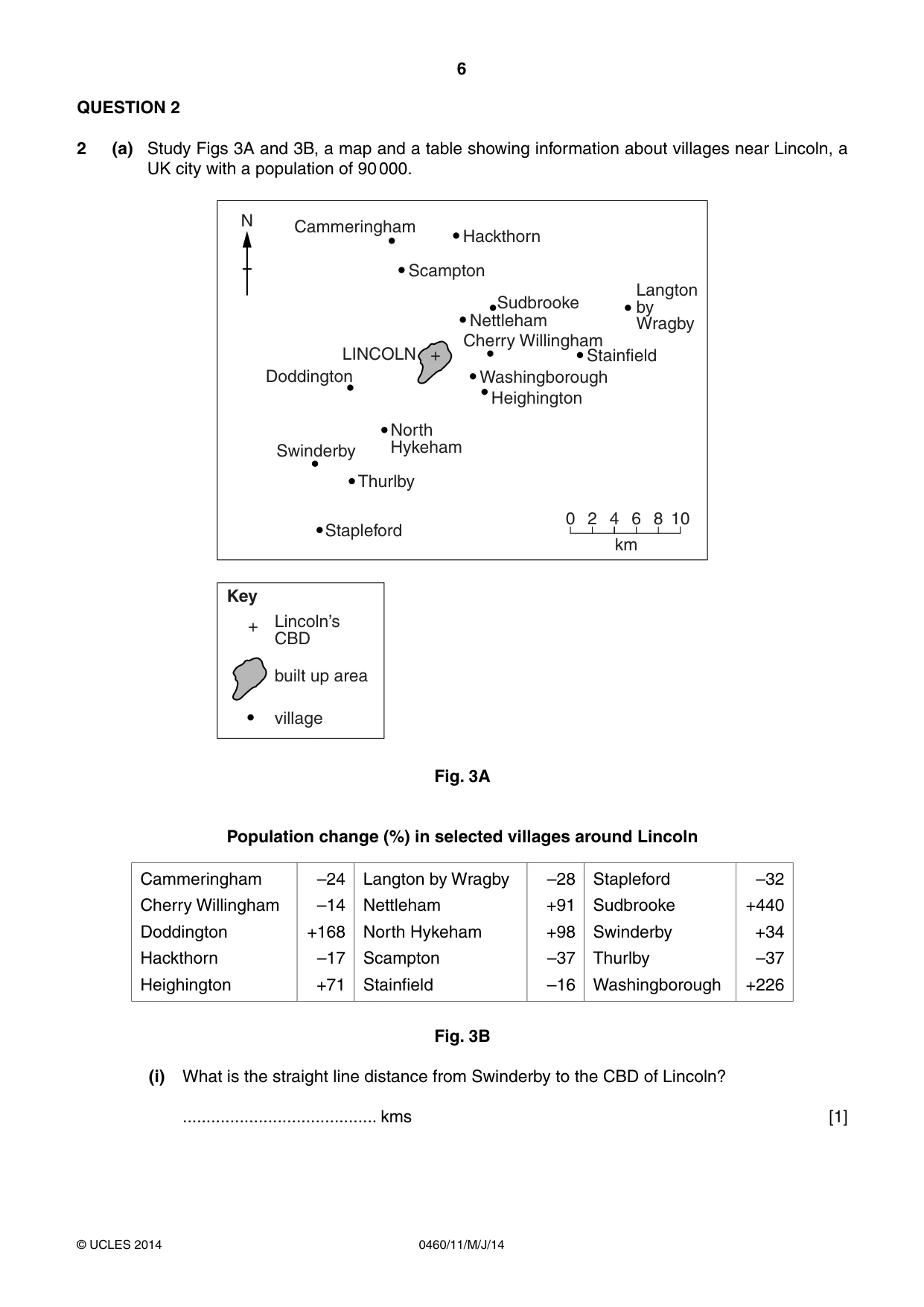
6 0460/11/M/J/14 © UCLES 2014 QUESTION 2 2 (a) Study Figs 3A and 3B, a map and a table showing information about villages near Lincoln, a UK city with a population of 90 000. + + Washingborough Nettleham Doddington Scampton Stapleford built up area village Lincoln’s CBD Key Thurlby North Hykeham Swinderby Hackthorn Cammeringham LINCOLN Sudbrooke Heighington Stainfield Cherry Willingham Langton by Wragby N 0 2 4 6 8 10 km Fig. 3A Population change (%) in selected villages around Lincoln Cammeringham Cherry Willingham Doddington Hackthorn Heighington –24 –14 +168 –17 +71 Langton by Wragby Nettleham North Hykeham Scampton Stainfield –28 +91 +98 –37 –16 Stapleford Sudbrooke Swinderby Thurlby Washingborough –32 +440 +34 –37 +226 Fig. 3B (i) What is the straight line distance from Swinderby to the CBD of Lincoln? … kms [1]
Question paper, page 7
7 0460/11/M/J/14 © UCLES 2014 [Turn over (ii) Using Fig. 3B, identify: A a village where the population has declined; … B the village where there has been the largest percentage population growth. …[2] (iii) Some villages near Lincoln have increased in population as people have moved from the nearby city. Suggest three different reasons why people may have moved from Lincoln to these villages. 1 … … 2 … … 3 … …[3] (iv) Explain why people who live in the villages shown in Fig. 3A may use the shops and services in Lincoln. … … … … … … … …[4]
Question paper, page 8
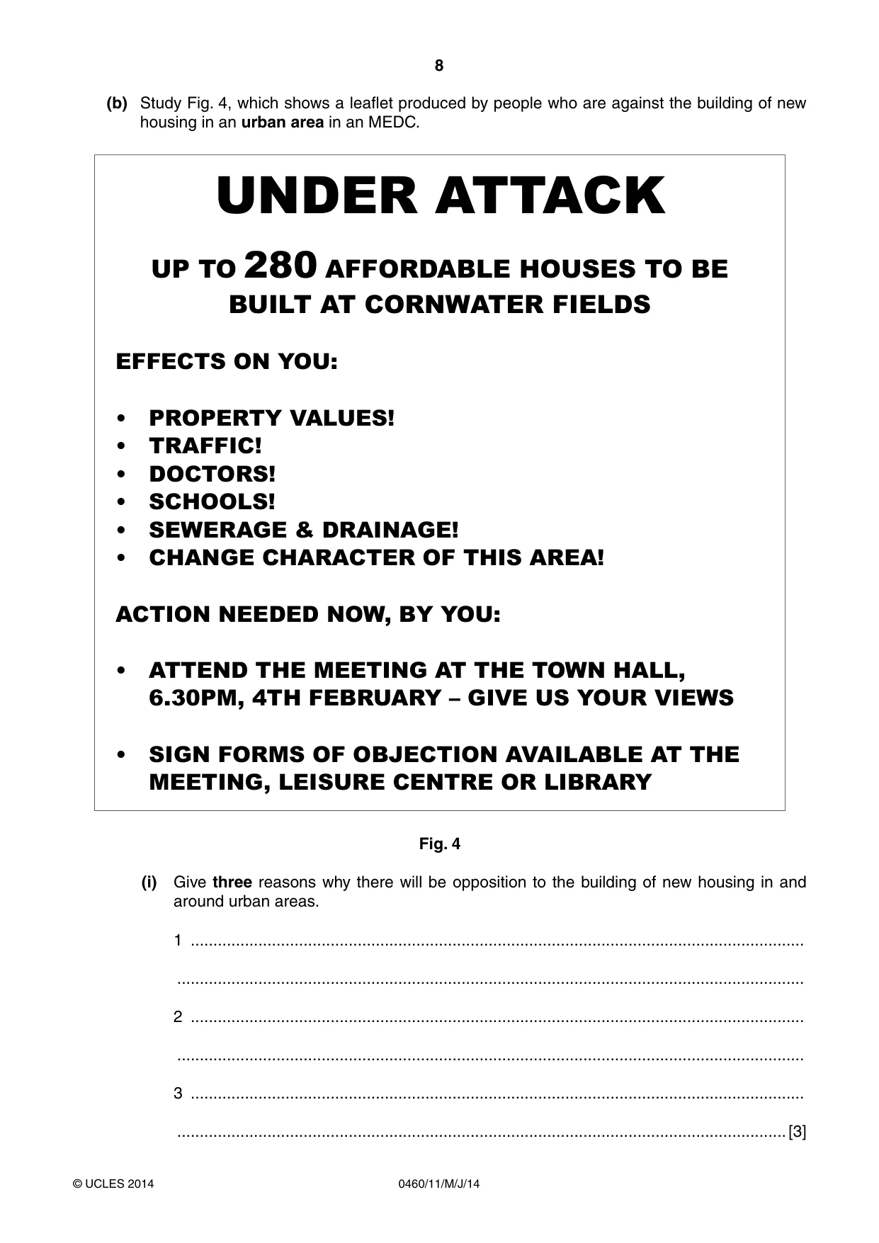
8 0460/11/M/J/14 © UCLES 2014 (b) Study Fig. 4, which shows a leaflet produced by people who are against the building of new housing in an urban area in an MEDC. UNDER ATTACK UP TO 280 AFFORDABLE HOUSES TO BE BUILT AT CORNWATER FIELDS EFFECTS ON YOU: • PROPERTY VALUES! • TRAFFIC! • DOCTORS! • SCHOOLS! • SEWERAGE & DRAINAGE! • CHANGE CHARACTER OF THIS AREA! ACTION NEEDED NOW, BY YOU: • ATTEND THE MEETING AT THE TOWN HALL, 6.30PM, 4TH FEBRUARY – GIVE US YOUR VIEWS • SIGN FORMS OF OBJECTION AVAILABLE AT THE MEETING, LEISURE CENTRE OR LIBRARY Fig. 4 (i) Give three reasons why there will be opposition to the building of new housing in and around urban areas. 1 … … 2 … … 3 … …[3]
Question paper, page 9
9 0460/11/M/J/14 © UCLES 2014 [Turn over (ii) Explain why new houses are needed in many urban areas in MEDCs. … … … … … … … … … …[5] (c) For a named urban area you have studied, describe the attempts taken to reduce the problems caused by traffic. Name of urban area … … … … … … … … … … … … … … …[7] [Total: 25 marks] END OF QUESTION 2
Question paper, page 10
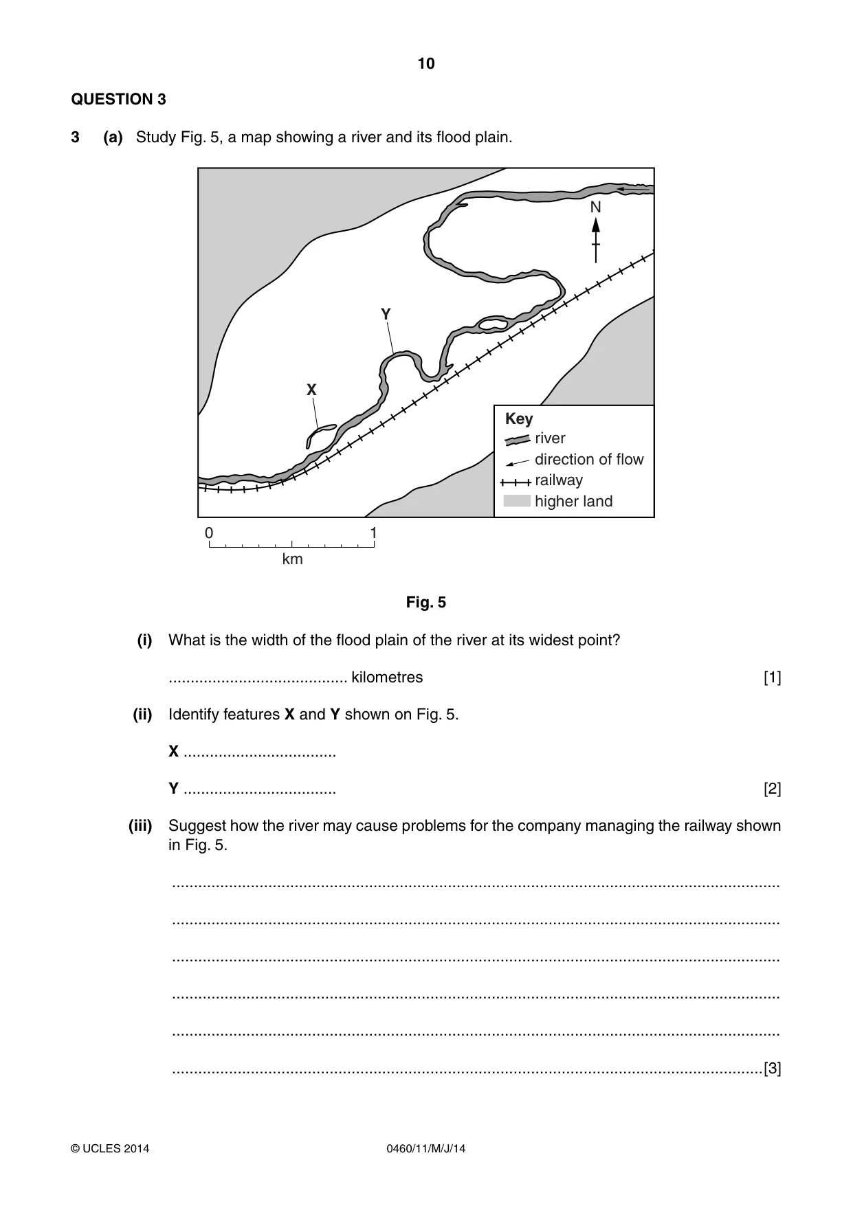
10 0460/11/M/J/14 © UCLES 2014 QUESTION 3 3 (a) Study Fig. 5, a map showing a river and its flood plain. N 0 1 km X Y river Key direction of flow railway higher land Fig. 5 (i) What is the width of the flood plain of the river at its widest point? … kilometres [1] (ii) Identify features X and Y shown on Fig. 5. X … Y … [2] (iii) Suggest how the river may cause problems for the company managing the railway shown in Fig. 5. … … … … … …[3]
Question paper, page 11
11 0460/11/M/J/14 © UCLES 2014 [Turn over (iv) Explain the formation of a flood plain. … … … … … … … …[4] (b) Study Photograph A (Insert), which shows a river which has flooded. (i) Suggest three possible causes of the flooding of the river shown in the photograph. 1 … … 2 … … 3 … …[3] (ii) Describe the likely impacts of floods for people who live in an urban area. … … … … … … … … … …[5]
Question paper, page 12
12 0460/11/M/J/14 © UCLES 2014 (c) For a named river you have studied, explain why people live on its flood plain or delta. Name of river … … … … … … … … … … … … … … …[7] [Total: 25 marks] END OF QUESTION 3
Question paper, page 13
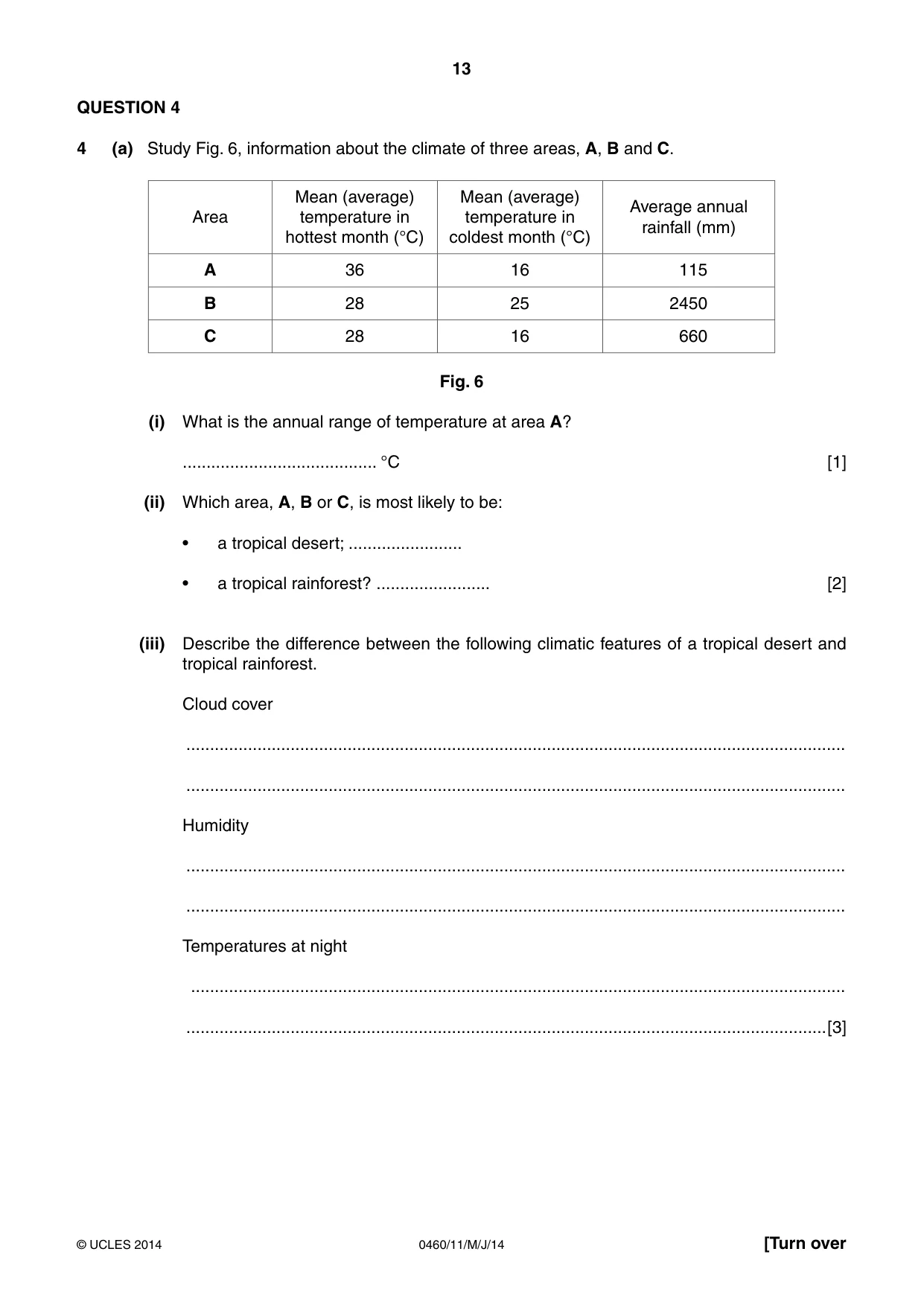
13 0460/11/M/J/14 © UCLES 2014 [Turn over QUESTION 4 4 (a) Study Fig. 6, information about the climate of three areas, A, B and C. Area Mean (average) temperature in hottest month (°C) Mean (average) temperature in coldest month (°C) Average annual rainfall (mm) A 36 16 115 B 28 25 2450 C 28 16 660 Fig. 6 (i) What is the annual range of temperature at area A? … °C [1] (ii) Which area, A, B or C, is most likely to be: • a tropical desert; … • a tropical rainforest? … [2] (iii) Describe the difference between the following climatic features of a tropical desert and tropical rainforest. Cloud cover … … Humidity … … Temperatures at night … …[3]
Question paper, page 14
14 0460/11/M/J/14 © UCLES 2014 (iv) Explain how the amount of rainfall in a tropical desert is influenced by wind direction and atmospheric pressure. Wind direction … … … … Atmospheric pressure … … … …[4] (b) Study Photograph B (Insert), which shows vegetation in an area of tropical desert. (i) Describe the characteristics of the vegetation shown in Photograph B. … … … … … …[3] (ii) Explain how the vegetation shown in Photograph B is adapted to the desert climate. … … … … … … … … … …[5]
Question paper, page 15
15 0460/11/M/J/14 © UCLES 2014 [Turn over (c) For a named area of tropical rainforest you have studied, describe the impacts of large scale deforestation on the local and global natural environment. Name of area of tropical rainforest … … … … … … … … … … … … … … …[7] [Total: 25 marks] END OF QUESTION 4
Question paper, page 16
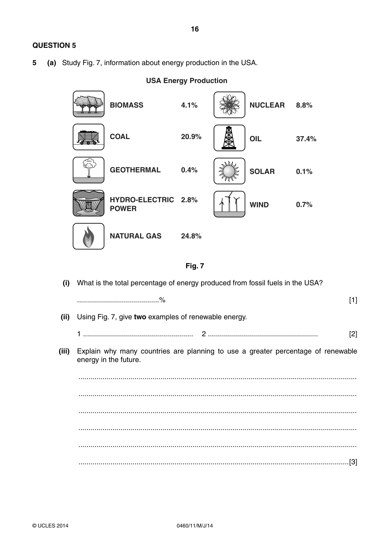
16 0460/11/M/J/14 © UCLES 2014 QUESTION 5 5 (a) Study Fig. 7, information about energy production in the USA. BIOMASS USA Energy Production COAL GEOTHERMAL HYDRO-ELECTRIC POWER NUCLEAR OIL SOLAR WIND NATURAL GAS 4.1% 20.9% 0.4% 2.8% 8.8% 37.4% 0.1% 0.7% 24.8% Fig. 7 (i) What is the total percentage of energy produced from fossil fuels in the USA? …% [1] (ii) Using Fig. 7, give two examples of renewable energy. 1 … 2 … [2] (iii) Explain why many countries are planning to use a greater percentage of renewable energy in the future. … … … … … …[3]
Question paper, page 17
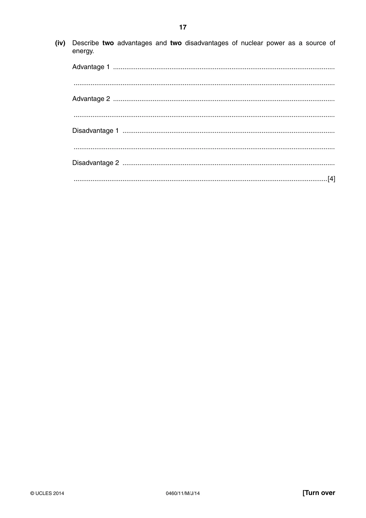
17 0460/11/M/J/14 © UCLES 2014 [Turn over (iv) Describe two advantages and two disadvantages of nuclear power as a source of energy. Advantage 1 … … Advantage 2 … … Disadvantage 1 … … Disadvantage 2 … …[4]
Question paper, page 18
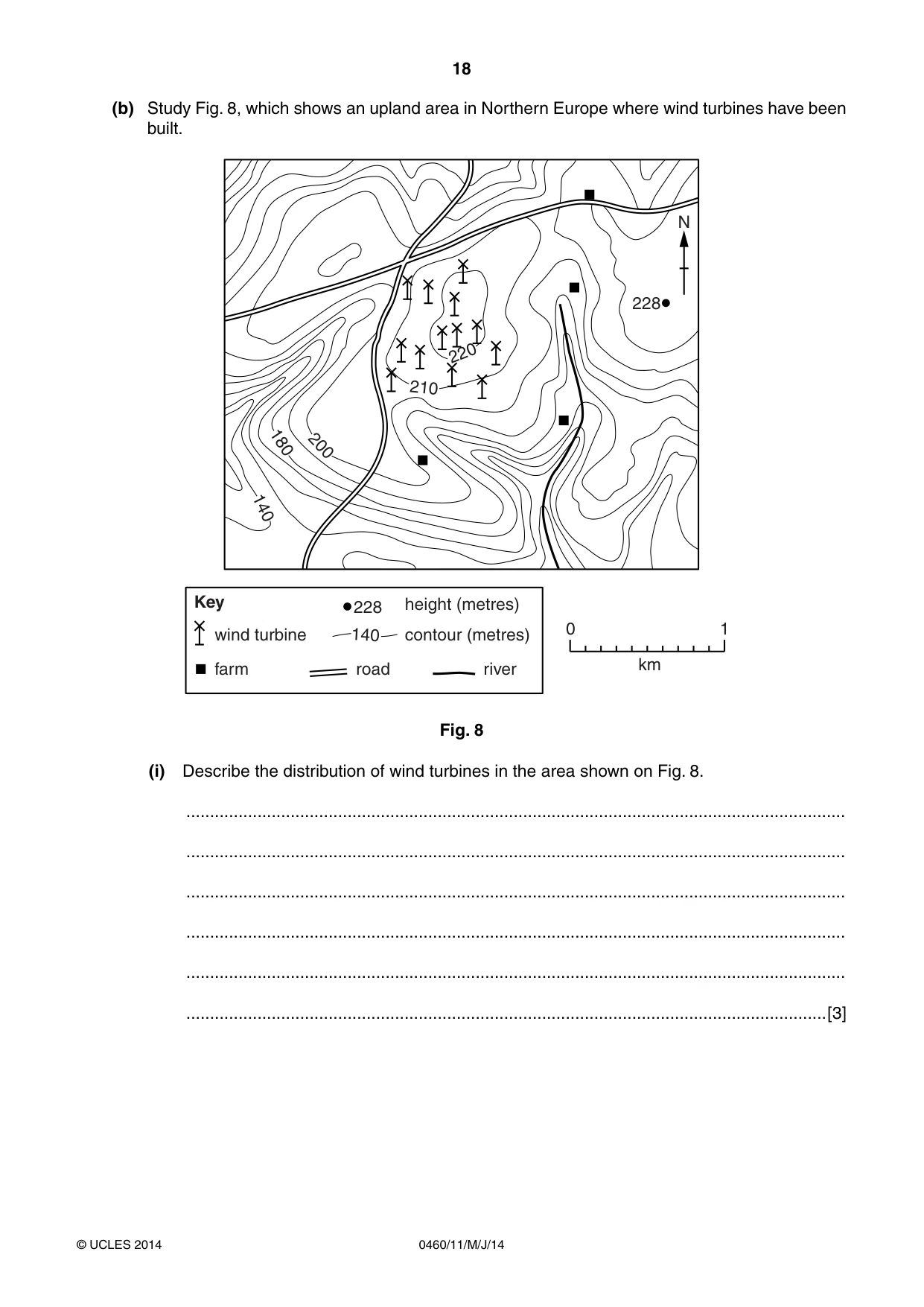
18 0460/11/M/J/14 © UCLES 2014 (b) Study Fig. 8, which shows an upland area in Northern Europe where wind turbines have been built. 200 210 220 180 140 228 140 Key 0 1 km wind turbine farm road river contour (metres) height (metres) N 228 Fig. 8 (i) Describe the distribution of wind turbines in the area shown on Fig. 8. … … … … … …[3]
Question paper, page 19
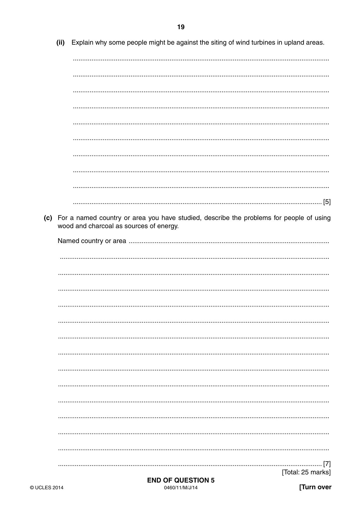
19 0460/11/M/J/14 © UCLES 2014 [Turn over (ii) Explain why some people might be against the siting of wind turbines in upland areas. … … … … … … … … … … [5] (c) For a named country or area you have studied, describe the problems for people of using wood and charcoal as sources of energy. Named country or area … … … … … … … … … … … … … … … [7] [Total: 25 marks] END OF QUESTION 5
Question paper, page 20
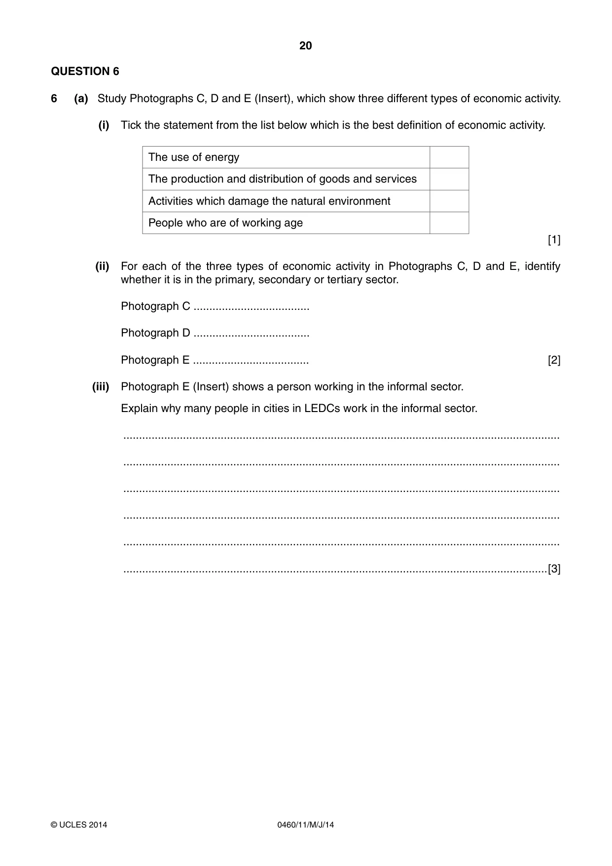
20 0460/11/M/J/14 © UCLES 2014 QUESTION 6 6 (a) Study Photographs C, D and E (Insert), which show three different types of economic activity. (i) Tick the statement from the list below which is the best definition of economic activity. The use of energy The production and distribution of goods and services Activities which damage the natural environment People who are of working age [1] (ii) For each of the three types of economic activity in Photographs C, D and E, identify whether it is in the primary, secondary or tertiary sector. Photograph C … Photograph D … Photograph E … [2] (iii) Photograph E (Insert) shows a person working in the informal sector. Explain why many people in cities in LEDCs work in the informal sector. … … … … … …[3]
Question paper, page 21
21 0460/11/M/J/14 © UCLES 2014 [Turn over (iv) The farmer shown in Photograph D (Insert) is using a simple machine. Suggest two advantages and two disadvantages of this type of technology for farmers in LEDCs. Advantages 1 … … 2 … … Disadvantages 1 … … 2 … …[4]
Question paper, page 22
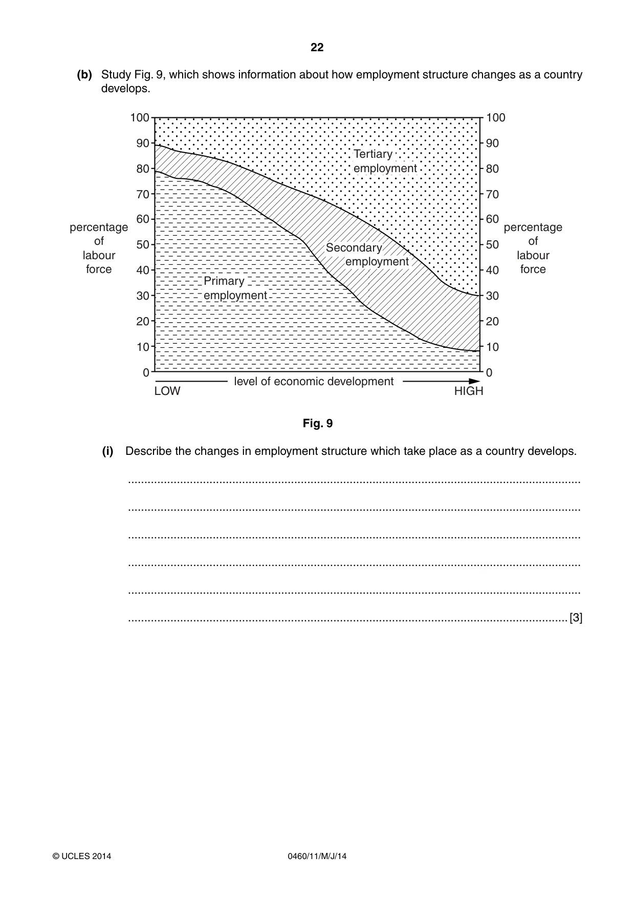
22 0460/11/M/J/14 © UCLES 2014 (b) Study Fig. 9, which shows information about how employment structure changes as a country develops. 100 90 80 70 60 50 40 30 20 10 0 100 90 80 70 60 50 40 30 20 10 0 percentage of labour force percentage of labour force level of economic development LOW HIGH Tertiary employment Primary employment Secondary employment Fig. 9 (i) Describe the changes in employment structure which take place as a country develops. … … … … … …[3]
Question paper, page 23
23 0460/11/M/J/14 © UCLES 2014 [Turn over (ii) Explain why employment structure changes as a country develops. … … … … … … … … … …[5]
Question paper, page 24
24 0460/11/M/J/14 © UCLES 2014 (c) Tourism is an important economic activity in many countries. For a country you have studied, describe its attractions and explain how they have encouraged the growth of the tourist industry. Name of country … … … … … … … … … … … … … … … …[7] [Total: 25 marks] END OF QUESTION 6
Question paper, page 25
25 0460/11/M/J/14 © UCLES 2014 Additional Page If you use the following lined page to complete the answer(s) to any question(s), the question number(s) must be clearly shown. … … … … … … … … … … … … … … … … … … … … … … … … … …
Question paper, page 26
26 0460/11/M/J/14 © UCLES 2014 BLANK PAGE
Question paper, page 27
27 0460/11/M/J/14 © UCLES 2014 BLANK PAGE
Question paper, page 28
28 0460/11/M/J/14 © UCLES 2014 Copyright Acknowledgements: Photographs A–E S Sibley © UCLES. Question 3 Fig. 5 Adapted from © Keith Hilton; Understanding Landforms; Nelson Thornes Ltd; 1984; ISBN 0333276434. Question 5 Fig. 7 © http://cleanet.org/clean/literacy/energyquiz.html Permission to reproduce items where third-party owned material protected by copyright is included has been sought and cleared where possible. Every reasonable effort has been made by the publisher (UCLES) to trace copyright holders, but if any items requiring clearance have unwittingly been included, the publisher will be pleased to make amends at the earliest possible opportunity. Cambridge International Examinations is part of the Cambridge Assessment Group. Cambridge Assessment is the brand name of University of Cambridge Local Examinations Syndicate (UCLES), which is itself a department of the University of Cambridge. BLANK PAGE
Mark scheme, page 1
CAMBRIDGE INTERNATIONAL EXAMINATIONS International General Certificate of Secondary Education MARK SCHEME for the May/June 2014 series 0460 GEOGRAPHY 0460/11 Paper 1, maximum raw mark 75 This mark scheme is published as an aid to teachers and candidates, to indicate the requirements of the examination. It shows the basis on which Examiners were instructed to award marks. It does not indicate the details of the discussions that took place at an Examiners’ meeting before marking began, which would have considered the acceptability of alternative answers. Mark schemes should be read in conjunction with the question paper and the Principal Examiner Report for Teachers. Cambridge will not enter into discussions about these mark schemes. Cambridge is publishing the mark schemes for the May/June 2014 series for most IGCSE, GCE Advanced Level and Advanced Subsidiary Level components and some Ordinary Level components.
Mark scheme, page 2
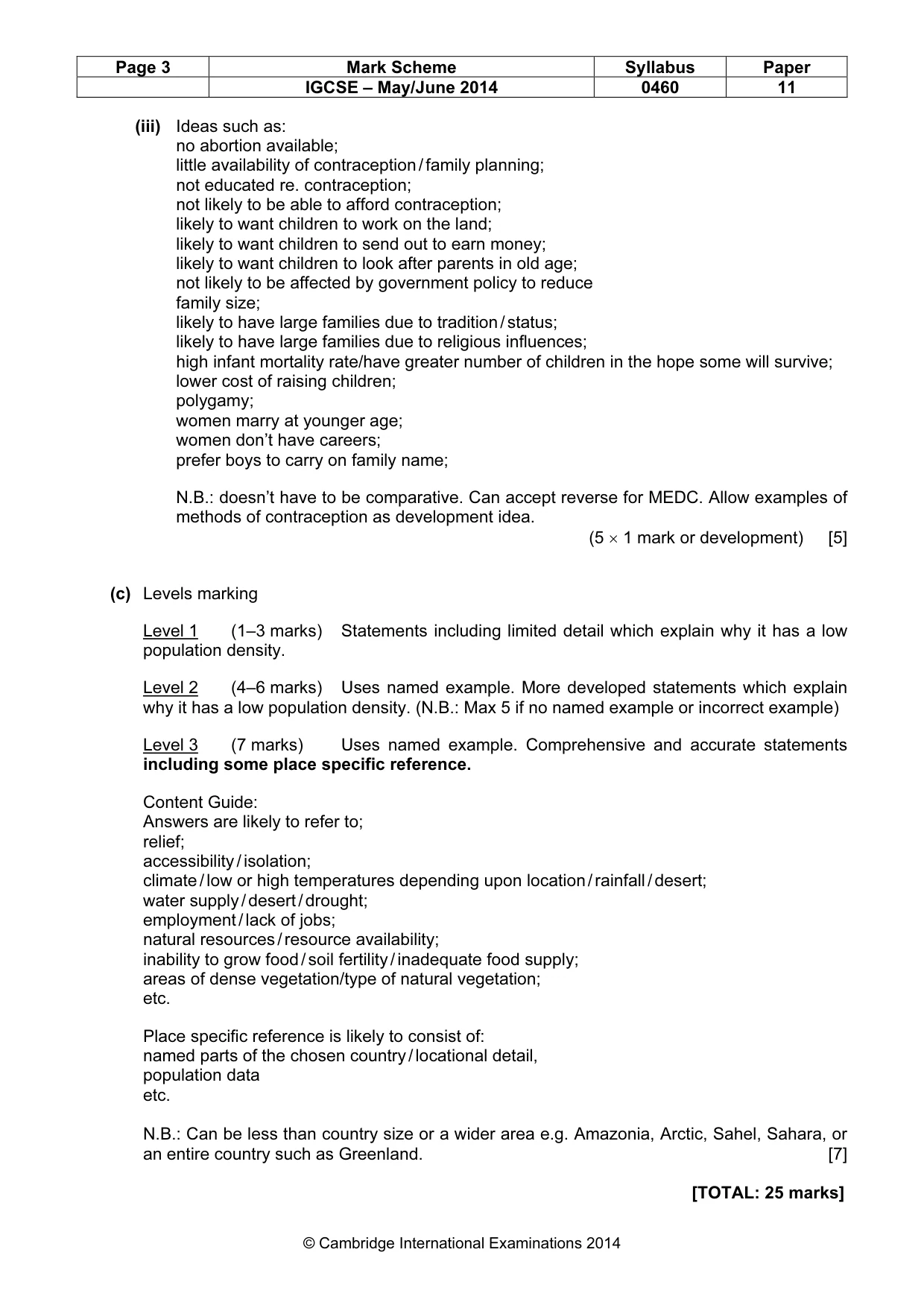
Page 2 Mark Scheme Syllabus Paper IGCSE – May/June 2014 0460 11 © Cambridge International Examinations 2014 1 (a) (i) 610 – 630 million (1 mark) [1] (ii) Europe Sub-Saharan Africa (2 × 1 mark) [2] (iii) Ideas such as: people do not have enough natural resources / raw materials; lack of fuel / power (or example such as electricity / wood supply); lack of work; poverty; inadequate food supplies/high food prices; starvation / malnutrition; poor access to education; poor access to healthcare / hospitals; high levels of disease / high death rate / high infant mortality rate; lack of / overcrowded housing / not enough space for housing; people live in squatter settlements; traffic congestion / increase in traffic; atmospheric pollution; water pollution; inadequate water supply / lack of water; inadequate sanitation; overuse of or lack of agricultural land / overcultivation; overgrazing; soil erosion; disputes over (agricultural) land/living space; deforestation / loss of vegetation; loss of habitat; loss of species / extinction; etc. (3 × 1 mark) [3] (b) (i) Identification of birth rate (18) and death rate (6) (1 mark) Birth rate minus death rate / 18 – 6 (1 mark) = 12 per thousand (3 × 1 mark) [3] (ii) Ideas such as; 1st idea is general decline in death rate; 2nd idea is steeper decline up to 1980; 3rd idea is it levels off / more gradual / slow decline after 1980; 4th idea can be any set of statistics plus years for example from 22 (1960) to 6 (2010) per 1000 / or another pair of years N.B.: Not necessary for per 1000 / units to be stated. (4 × 1 mark) [4]
Mark scheme, page 3
Page 3 Mark Scheme Syllabus Paper IGCSE – May/June 2014 0460 11 © Cambridge International Examinations 2014 (iii) Ideas such as: no abortion available; little availability of contraception / family planning; not educated re. contraception; not likely to be able to afford contraception; likely to want children to work on the land; likely to want children to send out to earn money; likely to want children to look after parents in old age; not likely to be affected by government policy to reduce family size; likely to have large families due to tradition / status; likely to have large families due to religious influences; high infant mortality rate/have greater number of children in the hope some will survive; lower cost of raising children; polygamy; women marry at younger age; women don’t have careers; prefer boys to carry on family name; N.B.: doesn’t have to be comparative. Can accept reverse for MEDC. Allow examples of methods of contraception as development idea. (5 × 1 mark or development) [5] (c) Levels marking Level 1 (1–3 marks) Statements including limited detail which explain why it has a low population density. Level 2 (4–6 marks) Uses named example. More developed statements which explain why it has a low population density. (N.B.: Max 5 if no named example or incorrect example) Level 3 (7 marks) Uses named example. Comprehensive and accurate statements including some place specific reference. Content Guide: Answers are likely to refer to; relief; accessibility / isolation; climate / low or high temperatures depending upon location / rainfall / desert; water supply / desert / drought; employment / lack of jobs; natural resources / resource availability; inability to grow food / soil fertility / inadequate food supply; areas of dense vegetation/type of natural vegetation; etc. Place specific reference is likely to consist of: named parts of the chosen country / locational detail, population data etc. N.B.: Can be less than country size or a wider area e.g. Amazonia, Arctic, Sahel, Sahara, or an entire country such as Greenland. [7] [TOTAL: 25 marks]
Mark scheme, page 4
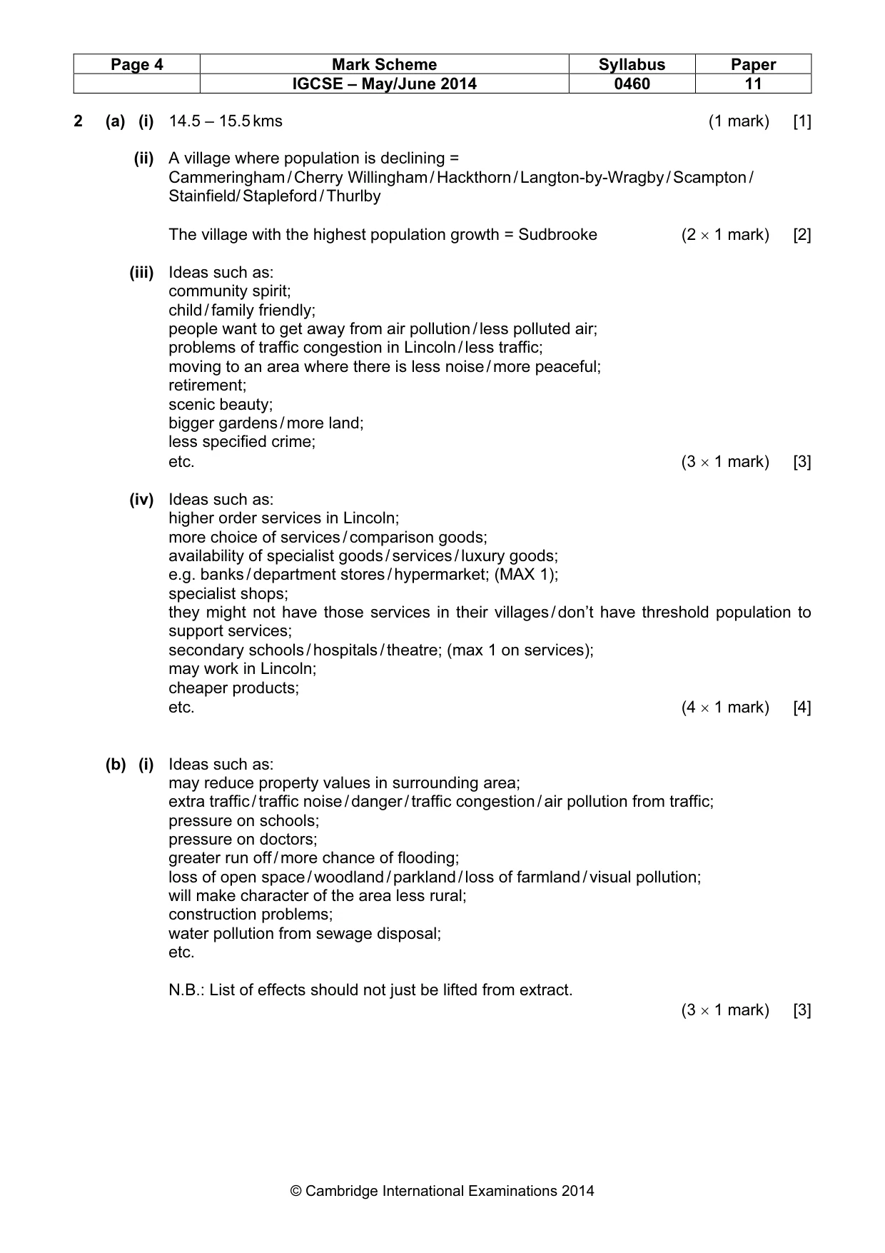
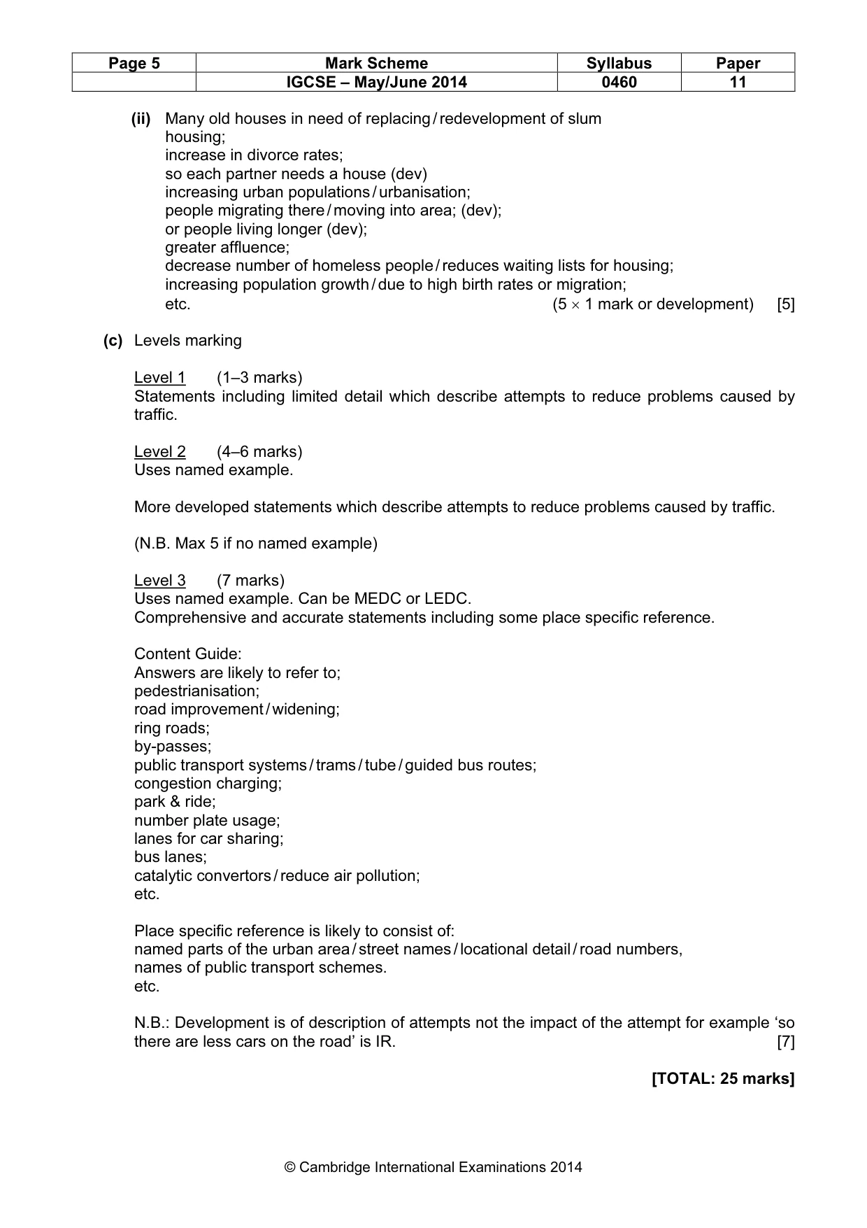
Page 4 Mark Scheme Syllabus Paper IGCSE – May/June 2014 0460 11 © Cambridge International Examinations 2014 2 (a) (i) 14.5 – 15.5 kms (1 mark) [1] (ii) A village where population is declining = Cammeringham / Cherry Willingham / Hackthorn / Langton-by-Wragby / Scampton / Stainfield/ Stapleford / Thurlby The village with the highest population growth = Sudbrooke (2 × 1 mark) [2] (iii) Ideas such as: community spirit; child / family friendly; people want to get away from air pollution / less polluted air; problems of traffic congestion in Lincoln / less traffic; moving to an area where there is less noise / more peaceful; retirement; scenic beauty; bigger gardens / more land; less specified crime; etc. (3 × 1 mark) [3] (iv) Ideas such as: higher order services in Lincoln; more choice of services / comparison goods; availability of specialist goods / services / luxury goods; e.g. banks / department stores / hypermarket; (MAX 1); specialist shops; they might not have those services in their villages / don’t have threshold population to support services; secondary schools / hospitals / theatre; (max 1 on services); may work in Lincoln; cheaper products; etc. (4 × 1 mark) [4] (b) (i) Ideas such as: may reduce property values in surrounding area; extra traffic / traffic noise / danger / traffic congestion / air pollution from traffic; pressure on schools; pressure on doctors; greater run off / more chance of flooding; loss of open space / woodland / parkland / loss of farmland / visual pollution; will make character of the area less rural; construction problems; water pollution from sewage disposal; etc. N.B.: List of effects should not just be lifted from extract. (3 × 1 mark) [3]
Mark scheme, page 5
Page 5 Mark Scheme Syllabus Paper IGCSE – May/June 2014 0460 11 © Cambridge International Examinations 2014 (ii) Many old houses in need of replacing / redevelopment of slum housing; increase in divorce rates; so each partner needs a house (dev) increasing urban populations / urbanisation; people migrating there / moving into area; (dev); or people living longer (dev); greater affluence; decrease number of homeless people / reduces waiting lists for housing; increasing population growth / due to high birth rates or migration; etc. (5 × 1 mark or development) [5] (c) Levels marking Level 1 (1–3 marks) Statements including limited detail which describe attempts to reduce problems caused by traffic. Level 2 (4–6 marks) Uses named example. More developed statements which describe attempts to reduce problems caused by traffic. (N.B. Max 5 if no named example) Level 3 (7 marks) Uses named example. Can be MEDC or LEDC. Comprehensive and accurate statements including some place specific reference. Content Guide: Answers are likely to refer to; pedestrianisation; road improvement / widening; ring roads; by-passes; public transport systems / trams / tube / guided bus routes; congestion charging; park & ride; number plate usage; lanes for car sharing; bus lanes; catalytic convertors / reduce air pollution; etc. Place specific reference is likely to consist of: named parts of the urban area / street names / locational detail / road numbers, names of public transport schemes. etc. N.B.: Development is of description of attempts not the impact of the attempt for example ‘so there are less cars on the road’ is IR. [7] [TOTAL: 25 marks]
Mark scheme, page 6
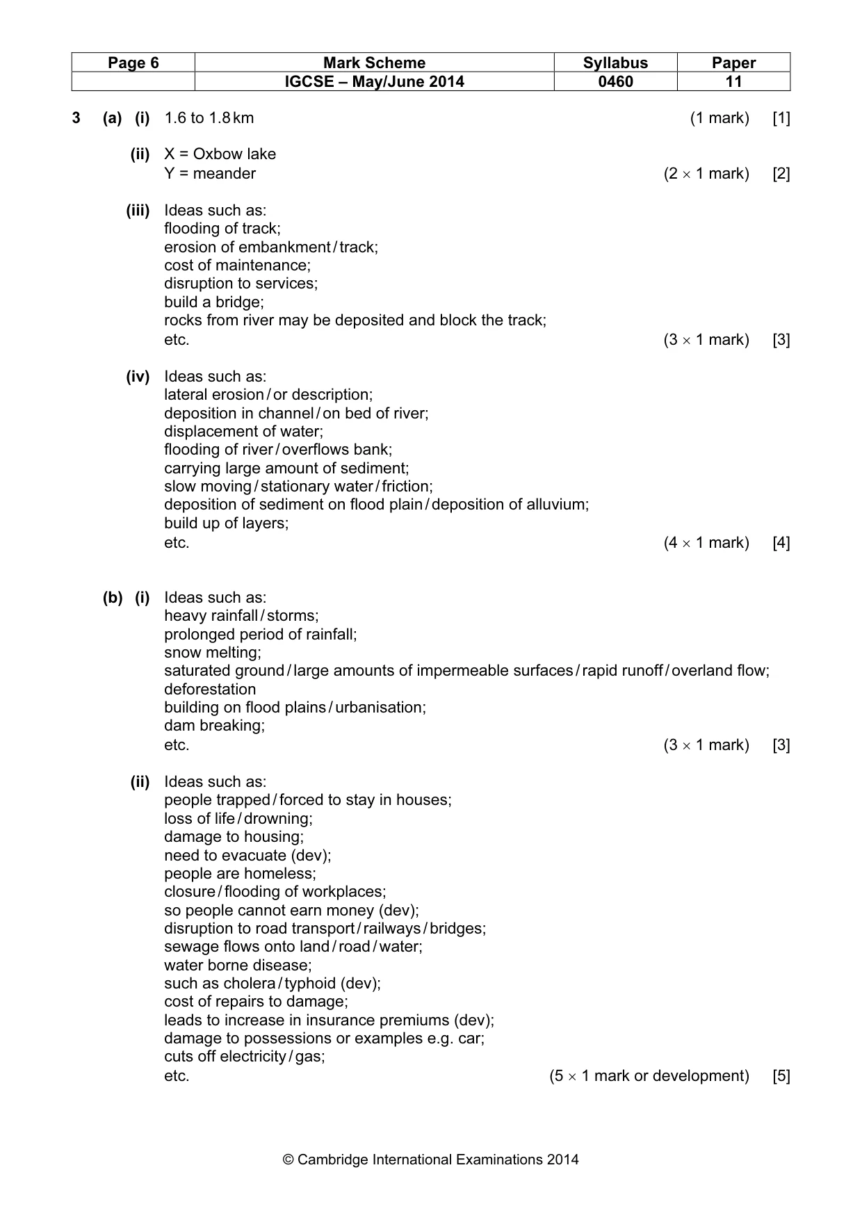
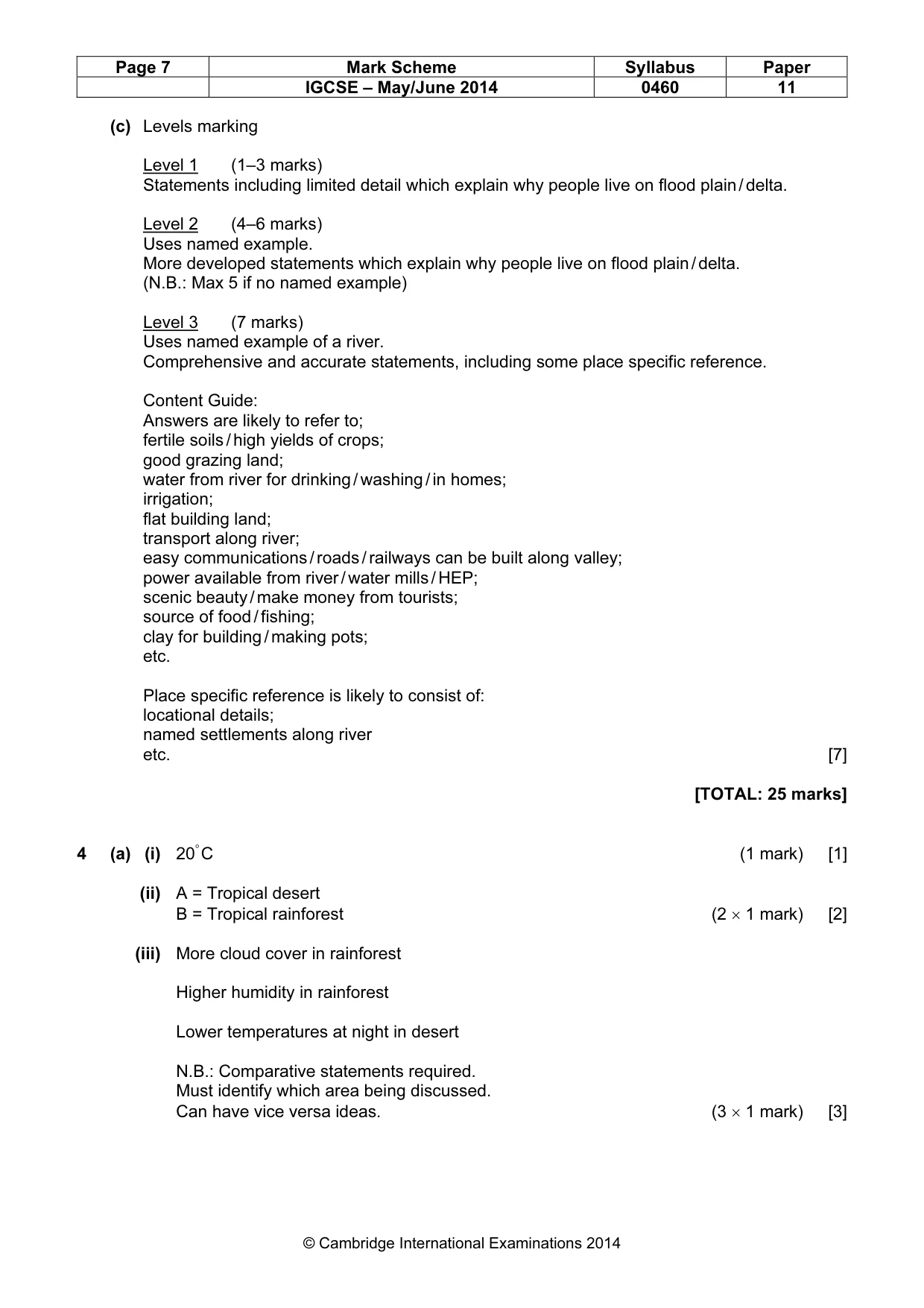
Page 6 Mark Scheme Syllabus Paper IGCSE – May/June 2014 0460 11 © Cambridge International Examinations 2014 3 (a) (i) 1.6 to 1.8 km (1 mark) [1] (ii) X = Oxbow lake Y = meander (2 × 1 mark) [2] (iii) Ideas such as: flooding of track; erosion of embankment / track; cost of maintenance; disruption to services; build a bridge; rocks from river may be deposited and block the track; etc. (3 × 1 mark) [3] (iv) Ideas such as: lateral erosion / or description; deposition in channel / on bed of river; displacement of water; flooding of river / overflows bank; carrying large amount of sediment; slow moving / stationary water / friction; deposition of sediment on flood plain / deposition of alluvium; build up of layers; etc. (4 × 1 mark) [4] (b) (i) Ideas such as: heavy rainfall / storms; prolonged period of rainfall; snow melting; saturated ground / large amounts of impermeable surfaces / rapid runoff / overland flow; deforestation building on flood plains / urbanisation; dam breaking; etc. (3 × 1 mark) [3] (ii) Ideas such as: people trapped / forced to stay in houses; loss of life / drowning; damage to housing; need to evacuate (dev); people are homeless; closure / flooding of workplaces; so people cannot earn money (dev); disruption to road transport / railways / bridges; sewage flows onto land / road / water; water borne disease; such as cholera / typhoid (dev); cost of repairs to damage; leads to increase in insurance premiums (dev); damage to possessions or examples e.g. car; cuts off electricity / gas; etc. (5 × 1 mark or development) [5]
Mark scheme, page 7
Page 7 Mark Scheme Syllabus Paper IGCSE – May/June 2014 0460 11 © Cambridge International Examinations 2014 (c) Levels marking Level 1 (1–3 marks) Statements including limited detail which explain why people live on flood plain / delta. Level 2 (4–6 marks) Uses named example. More developed statements which explain why people live on flood plain / delta. (N.B.: Max 5 if no named example) Level 3 (7 marks) Uses named example of a river. Comprehensive and accurate statements, including some place specific reference. Content Guide: Answers are likely to refer to; fertile soils / high yields of crops; good grazing land; water from river for drinking / washing / in homes; irrigation; flat building land; transport along river; easy communications / roads / railways can be built along valley; power available from river / water mills / HEP; scenic beauty / make money from tourists; source of food / fishing; clay for building / making pots; etc. Place specific reference is likely to consist of: locational details; named settlements along river etc. [7] [TOTAL: 25 marks] 4 (a) (i) 20° C (1 mark) [1] (ii) A = Tropical desert B = Tropical rainforest (2 × 1 mark) [2] (iii) More cloud cover in rainforest Higher humidity in rainforest Lower temperatures at night in desert N.B.: Comparative statements required. Must identify which area being discussed. Can have vice versa ideas. (3 × 1 mark) [3]
Mark scheme, page 8
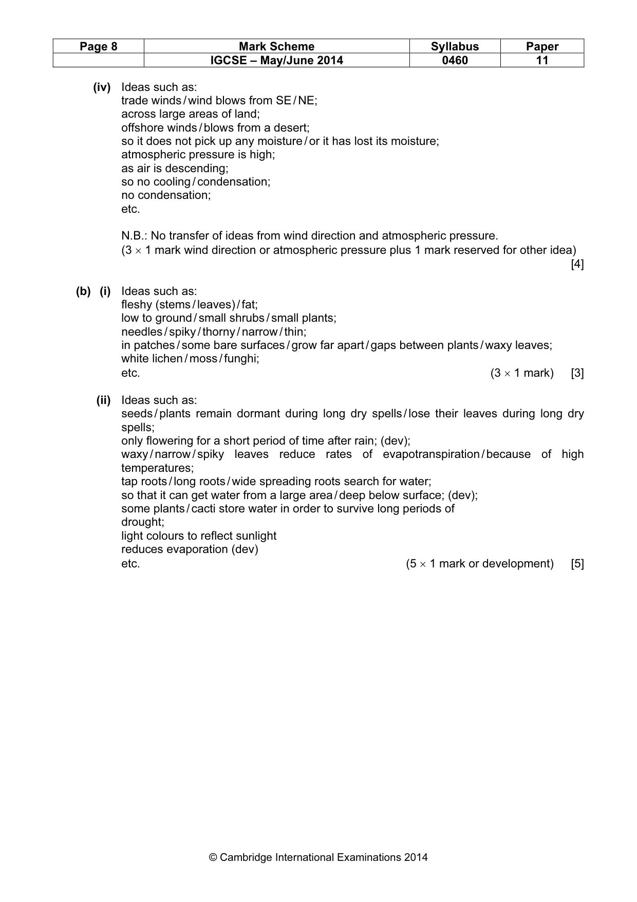
Page 8 Mark Scheme Syllabus Paper IGCSE – May/June 2014 0460 11 © Cambridge International Examinations 2014 (iv) Ideas such as: trade winds / wind blows from SE / NE; across large areas of land; offshore winds / blows from a desert; so it does not pick up any moisture / or it has lost its moisture; atmospheric pressure is high; as air is descending; so no cooling / condensation; no condensation; etc. N.B.: No transfer of ideas from wind direction and atmospheric pressure. (3 × 1 mark wind direction or atmospheric pressure plus 1 mark reserved for other idea) [4] (b) (i) Ideas such as: fleshy (stems / leaves) / fat; low to ground / small shrubs / small plants; needles / spiky / thorny / narrow / thin; in patches / some bare surfaces / grow far apart / gaps between plants / waxy leaves; white lichen / moss / funghi; etc. (3 × 1 mark) [3] (ii) Ideas such as: seeds / plants remain dormant during long dry spells / lose their leaves during long dry spells; only flowering for a short period of time after rain; (dev); waxy / narrow / spiky leaves reduce rates of evapotranspiration / because of high temperatures; tap roots / long roots / wide spreading roots search for water; so that it can get water from a large area / deep below surface; (dev); some plants / cacti store water in order to survive long periods of drought; light colours to reflect sunlight reduces evaporation (dev) etc. (5 × 1 mark or development) [5]
Mark scheme, page 9
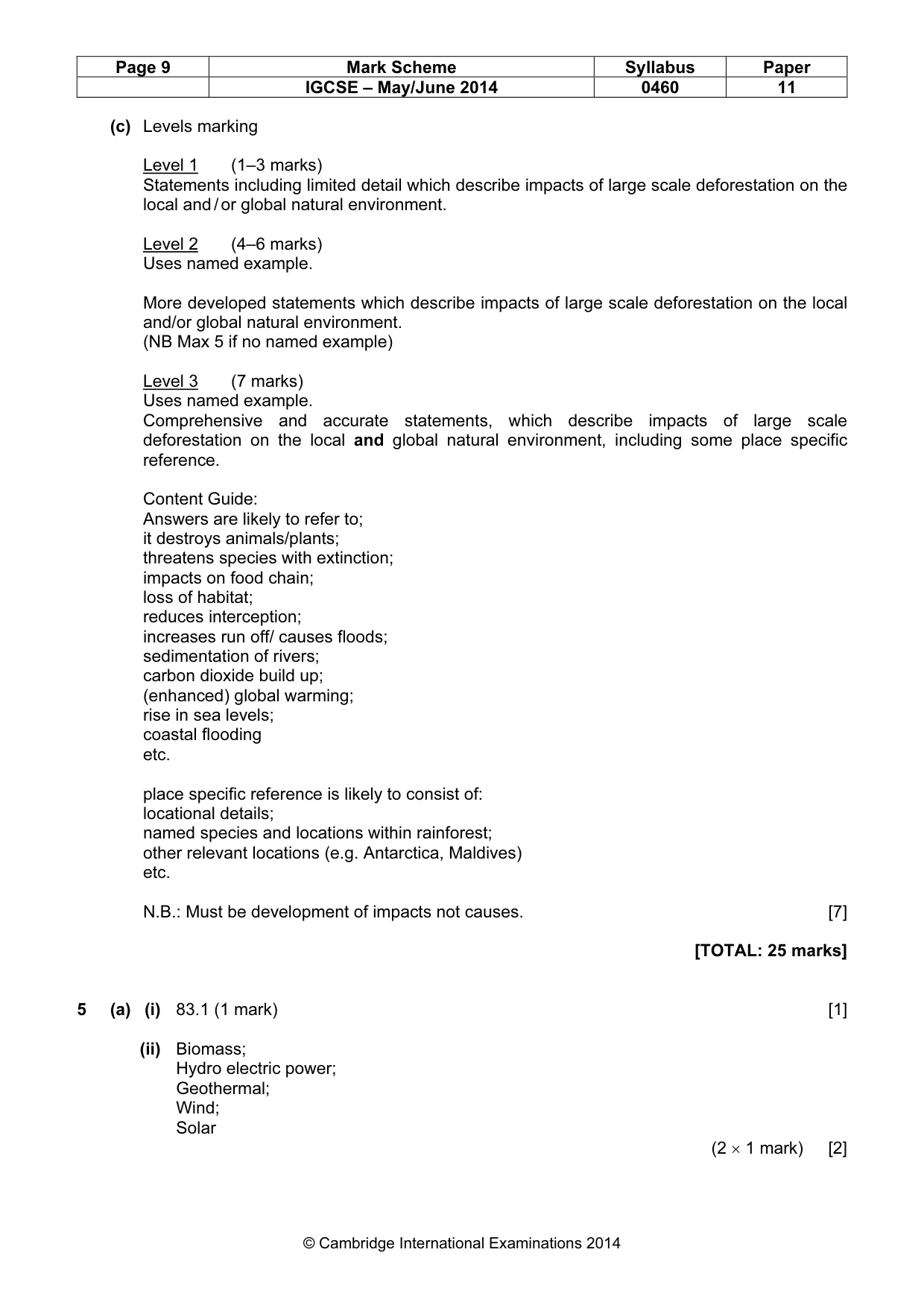
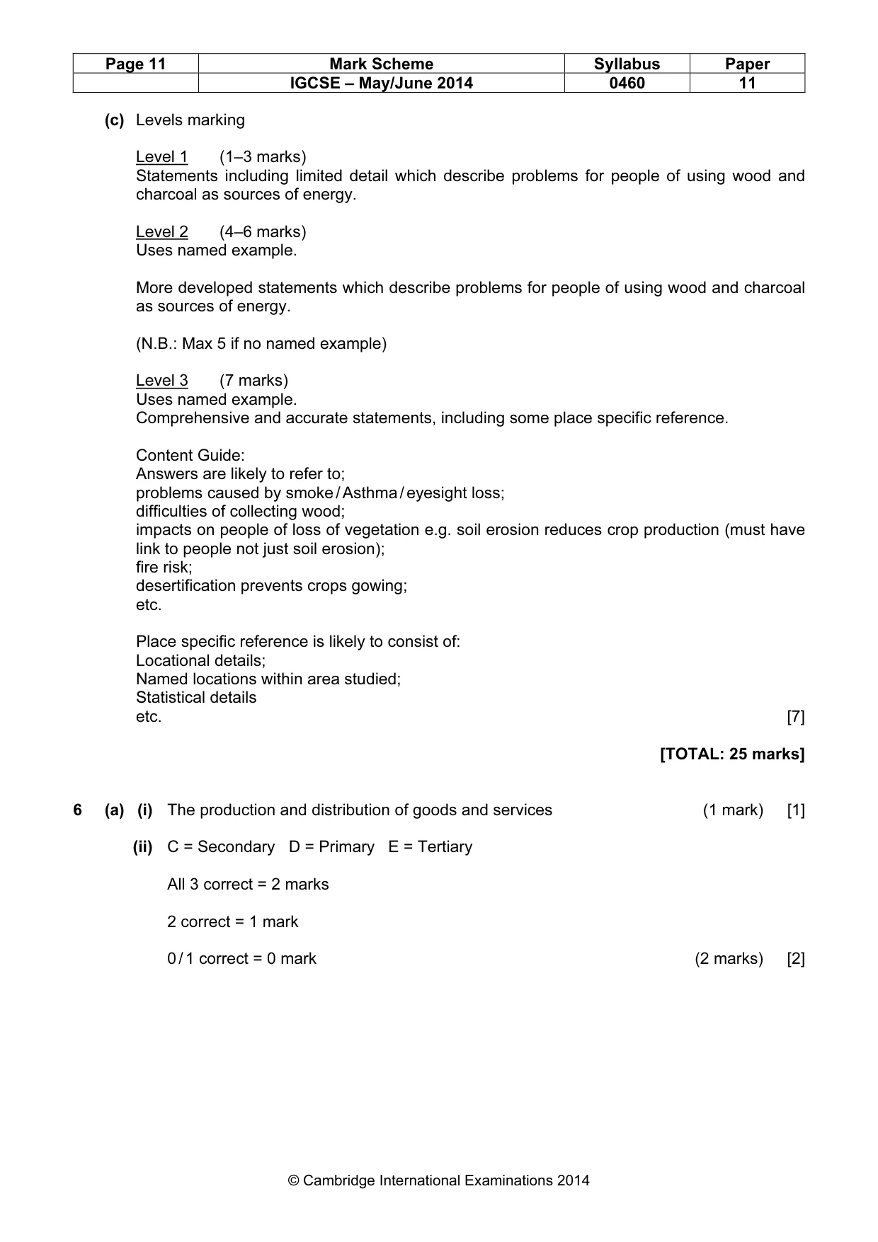
Page 9 Mark Scheme Syllabus Paper IGCSE – May/June 2014 0460 11 © Cambridge International Examinations 2014 (c) Levels marking Level 1 (1–3 marks) Statements including limited detail which describe impacts of large scale deforestation on the local and / or global natural environment. Level 2 (4–6 marks) Uses named example. More developed statements which describe impacts of large scale deforestation on the local and/or global natural environment. (NB Max 5 if no named example) Level 3 (7 marks) Uses named example. Comprehensive and accurate statements, which describe impacts of large scale deforestation on the local and global natural environment, including some place specific reference. Content Guide: Answers are likely to refer to; it destroys animals/plants; threatens species with extinction; impacts on food chain; loss of habitat; reduces interception; increases run off/ causes floods; sedimentation of rivers; carbon dioxide build up; (enhanced) global warming; rise in sea levels; coastal flooding etc. place specific reference is likely to consist of: locational details; named species and locations within rainforest; other relevant locations (e.g. Antarctica, Maldives) etc. N.B.: Must be development of impacts not causes. [7] [TOTAL: 25 marks] 5 (a) (i) 83.1 (1 mark) [1] (ii) Biomass; Hydro electric power; Geothermal; Wind; Solar (2 × 1 mark) [2]
Mark scheme, page 10
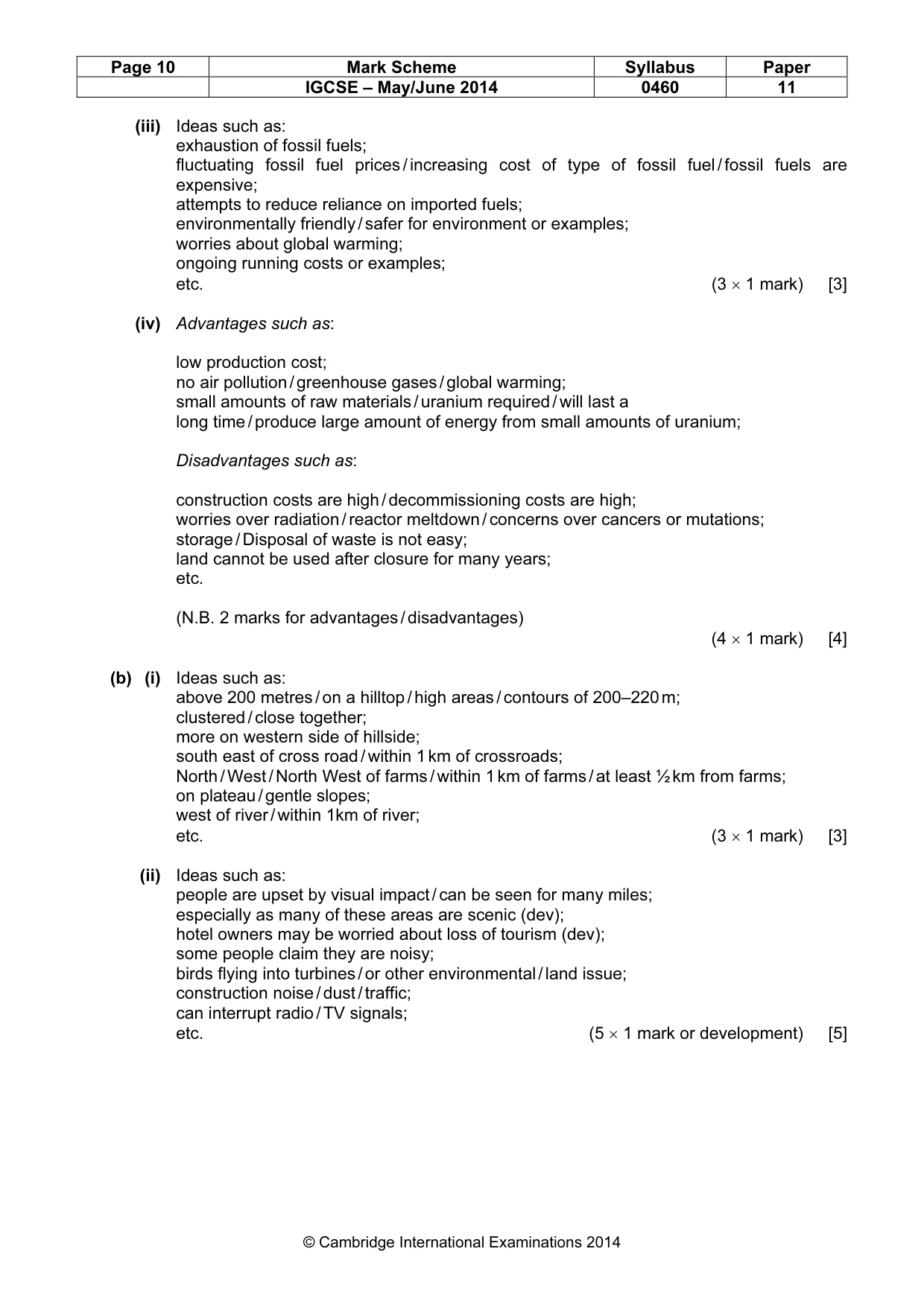
Page 10 Mark Scheme Syllabus Paper IGCSE – May/June 2014 0460 11 © Cambridge International Examinations 2014 (iii) Ideas such as: exhaustion of fossil fuels; fluctuating fossil fuel prices / increasing cost of type of fossil fuel / fossil fuels are expensive; attempts to reduce reliance on imported fuels; environmentally friendly / safer for environment or examples; worries about global warming; ongoing running costs or examples; etc. (3 × 1 mark) [3] (iv) Advantages such as: low production cost; no air pollution / greenhouse gases / global warming; small amounts of raw materials / uranium required / will last a long time / produce large amount of energy from small amounts of uranium; Disadvantages such as: construction costs are high / decommissioning costs are high; worries over radiation / reactor meltdown / concerns over cancers or mutations; storage / Disposal of waste is not easy; land cannot be used after closure for many years; etc. (N.B. 2 marks for advantages / disadvantages) (4 × 1 mark) [4] (b) (i) Ideas such as: above 200 metres / on a hilltop / high areas / contours of 200–220 m; clustered / close together; more on western side of hillside; south east of cross road / within 1 km of crossroads; North / West / North West of farms / within 1 km of farms / at least ½ km from farms; on plateau / gentle slopes; west of river / within 1km of river; etc. (3 × 1 mark) [3] (ii) Ideas such as: people are upset by visual impact / can be seen for many miles; especially as many of these areas are scenic (dev); hotel owners may be worried about loss of tourism (dev); some people claim they are noisy; birds flying into turbines / or other environmental / land issue; construction noise / dust / traffic; can interrupt radio / TV signals; etc. (5 × 1 mark or development) [5]
Mark scheme, page 11
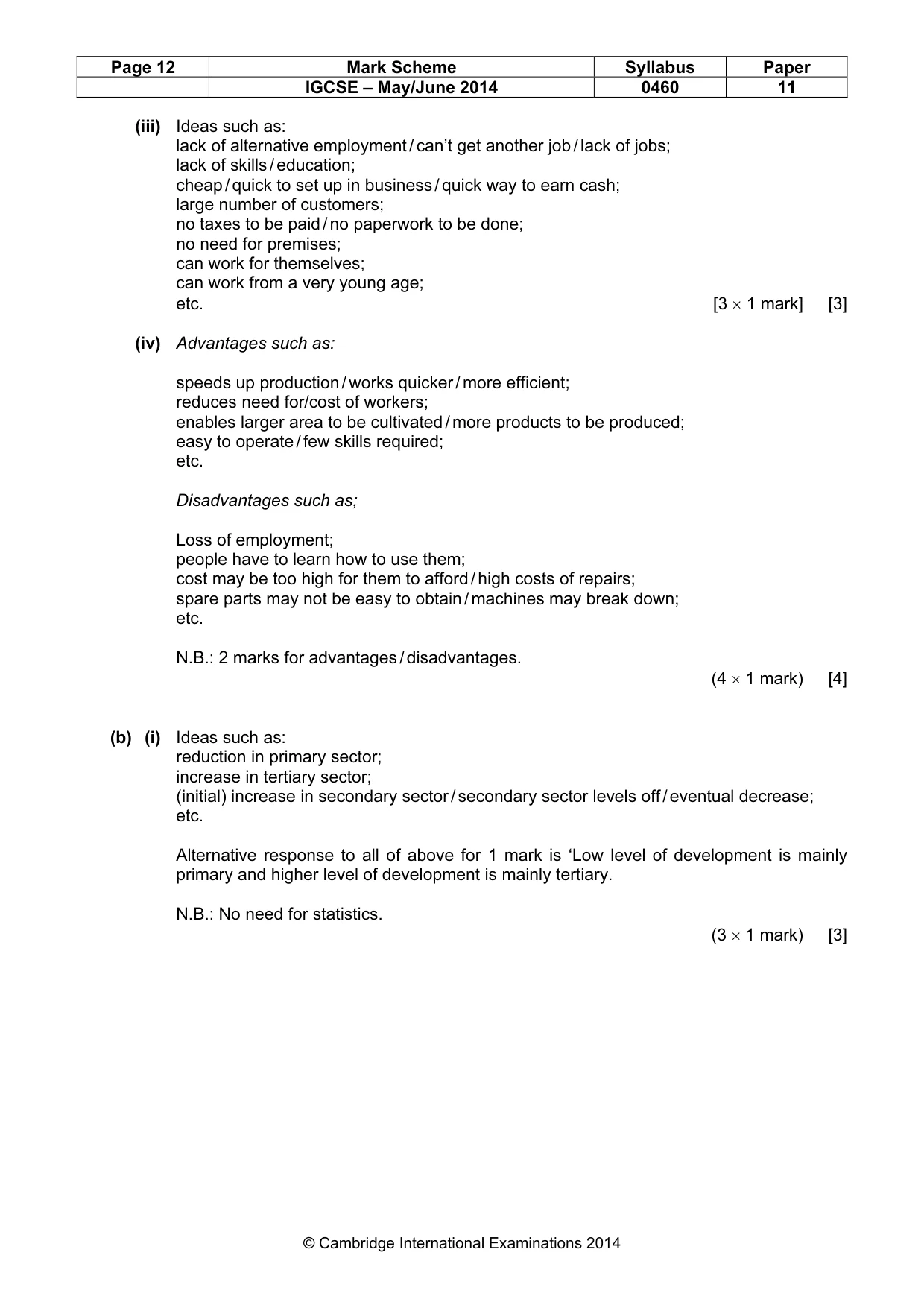
Page 11 Mark Scheme Syllabus Paper IGCSE – May/June 2014 0460 11 © Cambridge International Examinations 2014 (c) Levels marking Level 1 (1–3 marks) Statements including limited detail which describe problems for people of using wood and charcoal as sources of energy. Level 2 (4–6 marks) Uses named example. More developed statements which describe problems for people of using wood and charcoal as sources of energy. (N.B.: Max 5 if no named example) Level 3 (7 marks) Uses named example. Comprehensive and accurate statements, including some place specific reference. Content Guide: Answers are likely to refer to; problems caused by smoke / Asthma / eyesight loss; difficulties of collecting wood; impacts on people of loss of vegetation e.g. soil erosion reduces crop production (must have link to people not just soil erosion); fire risk; desertification prevents crops gowing; etc. Place specific reference is likely to consist of: Locational details; Named locations within area studied; Statistical details etc. [7] [TOTAL: 25 marks] 6 (a) (i) The production and distribution of goods and services (1 mark) [1] (ii) C = Secondary D = Primary E = Tertiary All 3 correct = 2 marks 2 correct = 1 mark 0 / 1 correct = 0 mark (2 marks) [2]
Mark scheme, page 12
Page 12 Mark Scheme Syllabus Paper IGCSE – May/June 2014 0460 11 © Cambridge International Examinations 2014 (iii) Ideas such as: lack of alternative employment / can’t get another job / lack of jobs; lack of skills / education; cheap / quick to set up in business / quick way to earn cash; large number of customers; no taxes to be paid / no paperwork to be done; no need for premises; can work for themselves; can work from a very young age; etc. [3 × 1 mark] [3] (iv) Advantages such as: speeds up production / works quicker / more efficient; reduces need for/cost of workers; enables larger area to be cultivated / more products to be produced; easy to operate / few skills required; etc. Disadvantages such as; Loss of employment; people have to learn how to use them; cost may be too high for them to afford / high costs of repairs; spare parts may not be easy to obtain / machines may break down; etc. N.B.: 2 marks for advantages / disadvantages. (4 × 1 mark) [4] (b) (i) Ideas such as: reduction in primary sector; increase in tertiary sector; (initial) increase in secondary sector / secondary sector levels off / eventual decrease; etc. Alternative response to all of above for 1 mark is ‘Low level of development is mainly primary and higher level of development is mainly tertiary. N.B.: No need for statistics. (3 × 1 mark) [3]
Mark scheme, page 13
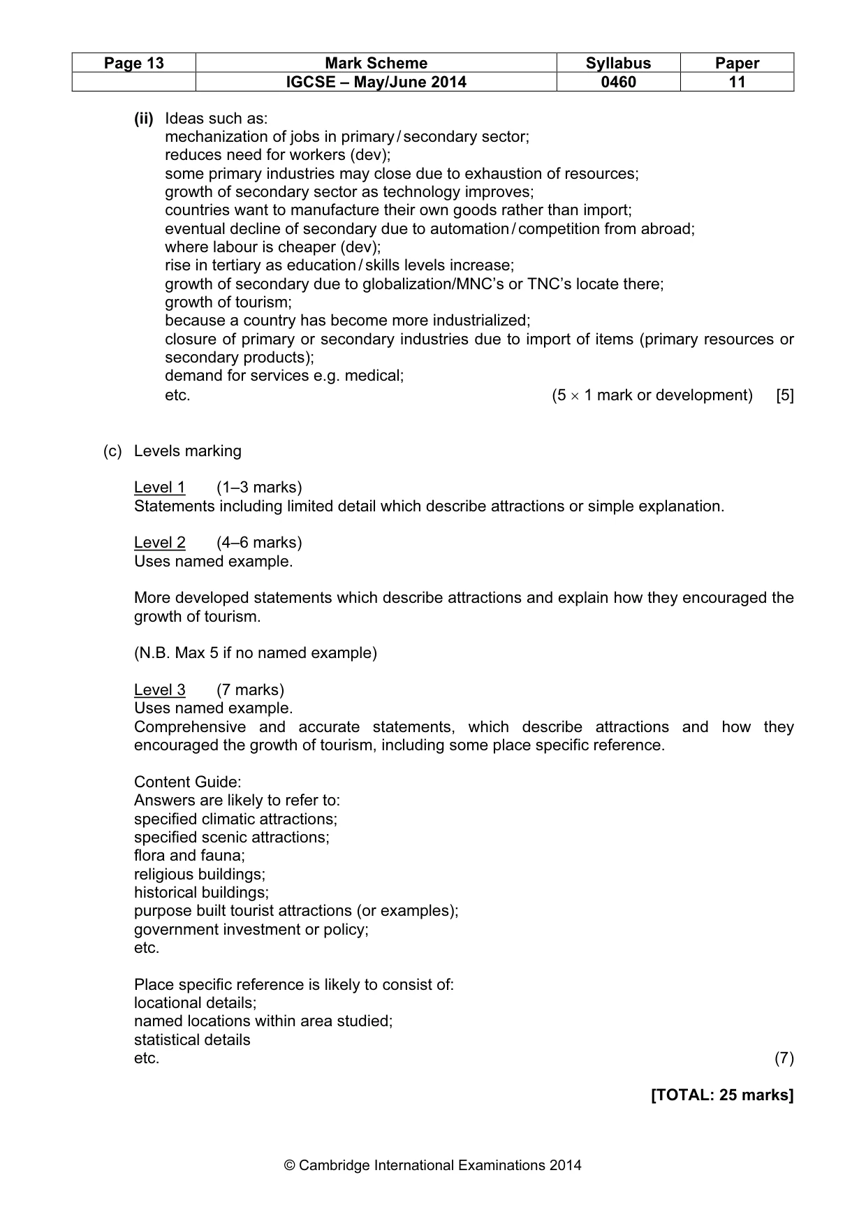
Page 13 Mark Scheme Syllabus Paper IGCSE – May/June 2014 0460 11 © Cambridge International Examinations 2014 (ii) Ideas such as: mechanization of jobs in primary / secondary sector; reduces need for workers (dev); some primary industries may close due to exhaustion of resources; growth of secondary sector as technology improves; countries want to manufacture their own goods rather than import; eventual decline of secondary due to automation / competition from abroad; where labour is cheaper (dev); rise in tertiary as education / skills levels increase; growth of secondary due to globalization/MNC’s or TNC’s locate there; growth of tourism; because a country has become more industrialized; closure of primary or secondary industries due to import of items (primary resources or secondary products); demand for services e.g. medical; etc. (5 × 1 mark or development) [5] (c) Levels marking Level 1 (1–3 marks) Statements including limited detail which describe attractions or simple explanation. Level 2 (4–6 marks) Uses named example. More developed statements which describe attractions and explain how they encouraged the growth of tourism. (N.B. Max 5 if no named example) Level 3 (7 marks) Uses named example. Comprehensive and accurate statements, which describe attractions and how they encouraged the growth of tourism, including some place specific reference. Content Guide: Answers are likely to refer to: specified climatic attractions; specified scenic attractions; flora and fauna; religious buildings; historical buildings; purpose built tourist attractions (or examples); government investment or policy; etc. Place specific reference is likely to consist of: locational details; named locations within area studied; statistical details etc. (7) [TOTAL: 25 marks]
What you needed in this session
Cambridge’s own grade thresholds for 2014 May/June, Paper 1 · Variant 1. A higher threshold means an easier paper — the bar moves with how the cohort did.