Cambridge IGCSE Geography 0460 — 2014 May/June Paper 1 · Variant 3
0460/13/M/J/14 · 75 marks · ≈84 min
The question paper and its mark scheme, free to read here and free to download. This is Cambridge’s own paper, exactly as it was sat.
Question paper28 pages


Mark scheme14 pages
Answers below. Sit the paper first if you are practising.
Paper as text
Question paper, page 1
GEOGRAPHY 0460/13 Paper 1 May/June 2014 1 hour 45 minutes Candidates answer on the Question Paper. Additional Materials: Ruler Calculator READ THESE INSTRUCTIONS FIRST Write your Centre number, candidate number and name in the spaces provided. Write in dark blue or black pen. You may use an HB pencil for any diagrams or graphs. Do not use staples, paper clips, glue or correction fluid. DO NOT WRITE IN ANY BARCODES. Write your answer to each question in the space provided. If additional space is required, you should use the lined page at the end of this booklet. The question number(s) must be clearly shown. Answer three questions. The Insert contains Photographs A and B for Question 2, Fig. 4 for Question 3, Photograph C for Question 4, Photographs D and E for Question 5, and Photograph F for Question 6. The Insert is not required by the Examiner. Sketch maps and diagrams should be drawn whenever they serve to illustrate an answer. At the end of the examination, fasten all your work securely together. The number of marks is given in brackets [ ] at the end of each question or part question. This document consists of 25 printed pages, 3 blank pages and 1 Insert. DC (NF/CGW) 79532/9 © UCLES 2014 [Turn over Cambridge International Examinations Cambridge International General Certificate of Secondary Education * 0 7 7 6 9 5 5 9 3 9 * The syllabus is approved for use in England, Wales and Northern Ireland as a Cambridge International Level 1/Level 2 Certificate.
Question paper, page 2
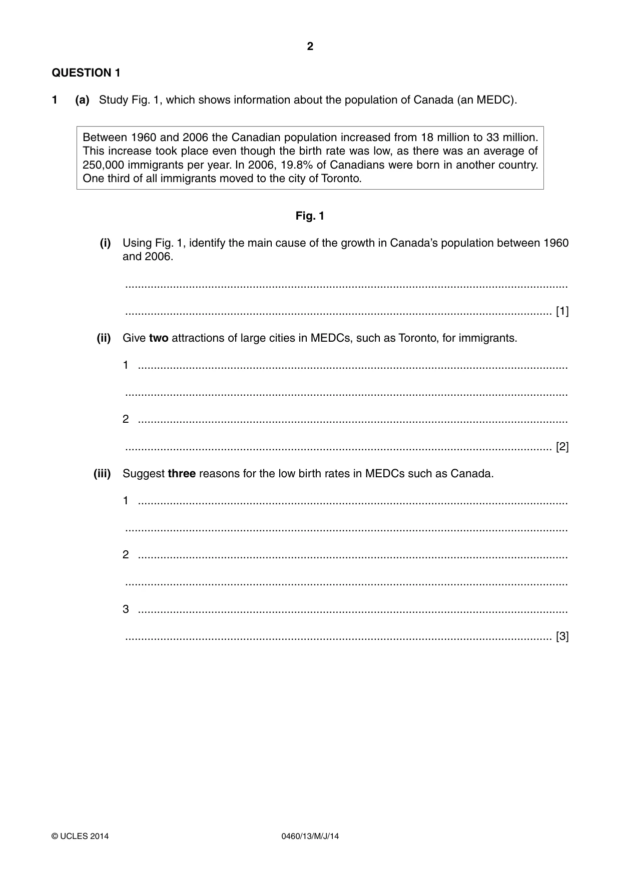
2 0460/13/M/J/14 © UCLES 2014 QUESTION 1 1 (a) Study Fig. 1, which shows information about the population of Canada (an MEDC). Between 1960 and 2006 the Canadian population increased from 18 million to 33 million. This increase took place even though the birth rate was low, as there was an average of 250,000 immigrants per year. In 2006, 19.8% of Canadians were born in another country. One third of all immigrants moved to the city of Toronto. Fig. 1 (i) Using Fig. 1, identify the main cause of the growth in Canada’s population between 1960 and 2006. … … [1] (ii) Give two attractions of large cities in MEDCs, such as Toronto, for immigrants. 1 … … 2 … … [2] (iii) Suggest three reasons for the low birth rates in MEDCs such as Canada. 1 … … 2 … … 3 … … [3]
Question paper, page 3
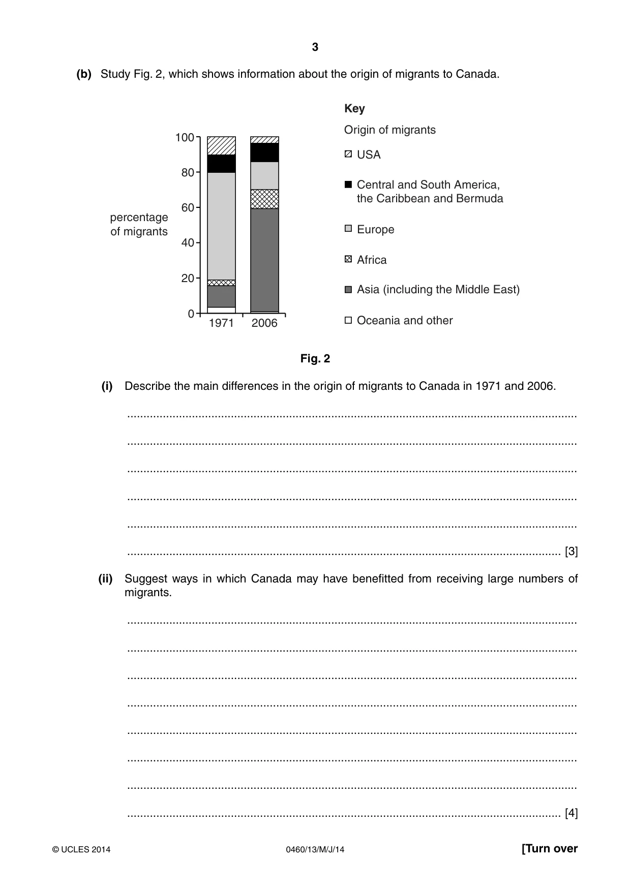
3 0460/13/M/J/14 © UCLES 2014 [Turn over (b) Study Fig. 2, which shows information about the origin of migrants to Canada. 100 USA Origin of migrants Key Central and South America, the Caribbean and Bermuda Europe 80 60 percentage of migrants 40 20 1971 2006 0 Africa Oceania and other Asia (including the Middle East) Fig. 2 (i) Describe the main differences in the origin of migrants to Canada in 1971 and 2006. … … … … … … [3] (ii) Suggest ways in which Canada may have benefitted from receiving large numbers of migrants. … … … … … … … … [4]
Question paper, page 4
4 0460/13/M/J/14 © UCLES 2014 (iii) Explain the likely difficulties for migrants from Asia (including the Middle East) when living in Canada. … … … … … … … … … … [5]
Question paper, page 5
5 0460/13/M/J/14 © UCLES 2014 [Turn over (c) For a named country you have studied, explain the push factors which have caused large amounts of migration from it. Name of country … … … … … … … … … … … … … … … [7] [Total: 25 marks] END OF QUESTION 1
Question paper, page 6
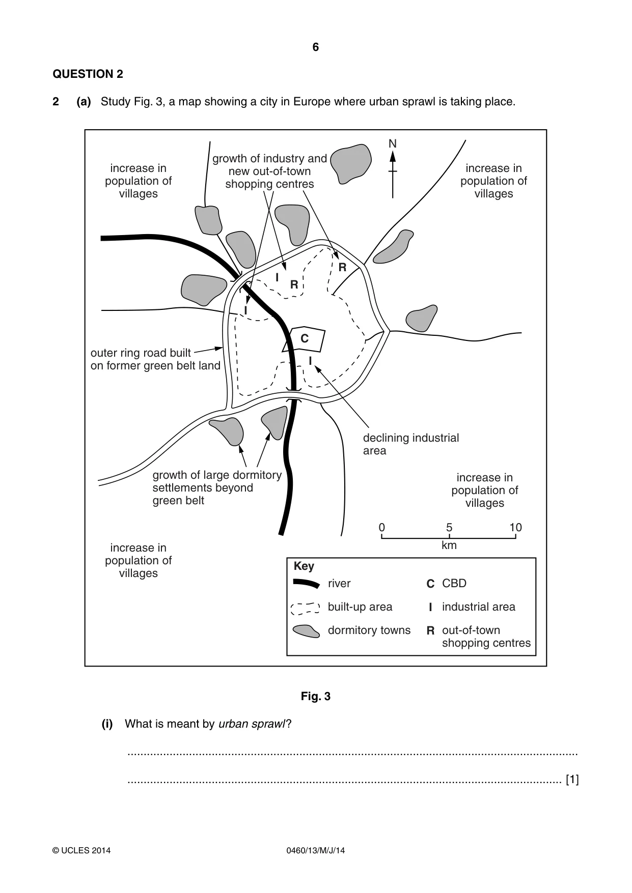
6 0460/13/M/J/14 © UCLES 2014 QUESTION 2 2 (a) Study Fig. 3, a map showing a city in Europe where urban sprawl is taking place. increase in population of villages increase in population of villages increase in population of villages 0 river built-up area dormitory towns CBD industrial area out-of-town shopping centres 5 10 km Key increase in population of villages N R R C C I R I I I outer ring road built on former green belt land growth of large dormitory settlements beyond green belt growth of industry and new out-of-town shopping centres declining industrial area Fig. 3 (i) What is meant by urban sprawl? … … [1]
Question paper, page 7
7 0460/13/M/J/14 © UCLES 2014 [Turn over (ii) Using Fig. 3, describe the location of the areas where: industry is declining; … … dormitory settlements are growing. … … [2] (iii) Explain how the growth of out-of-town shopping centres may affect the CBD. … … … … … … [3] (iv) Suggest reasons why industry is growing in some parts of the city shown in Fig. 3 but declining in others. … … … … … … … … [4]
Question paper, page 8
8 0460/13/M/J/14 © UCLES 2014 (b) Study Photographs A and B (Insert), which show part of a CBD (Photograph A) and part of a suburban shopping centre (Photograph B). (i) Using only evidence from Photographs A and B, identify three differences between the two shopping centres. 1 … … 2 … … 3 … … [3] (ii) Explain why services in a CBD have a larger sphere of influence than services in a suburban shopping centre. … … … … … … … … … … [5]
Question paper, page 9
9 0460/13/M/J/14 © UCLES 2014 [Turn over (c) For a named urban area you have studied, describe the attempts to reduce traffic congestion. Name of urban area … … … … … … … … … … … … … … … … [7] [Total: 25 marks] END OF QUESTION 2
Question paper, page 10
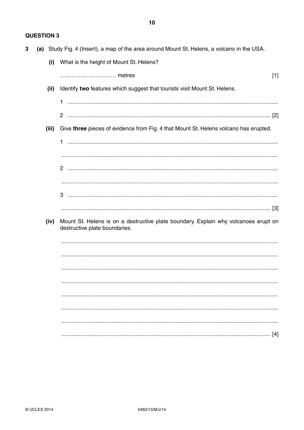
10 0460/13/M/J/14 © UCLES 2014 QUESTION 3 3 (a) Study Fig. 4 (Insert), a map of the area around Mount St. Helens, a volcano in the USA. (i) What is the height of Mount St. Helens? ………………………… metres [1] (ii) Identify two features which suggest that tourists visit Mount St. Helens. 1 … 2 … [2] (iii) Give three pieces of evidence from Fig. 4 that Mount St. Helens volcano has erupted. 1 … … 2 … … 3 … … [3] (iv) Mount St. Helens is on a destructive plate boundary. Explain why volcanoes erupt on destructive plate boundaries. … … … … … … … … [4]
Question paper, page 11
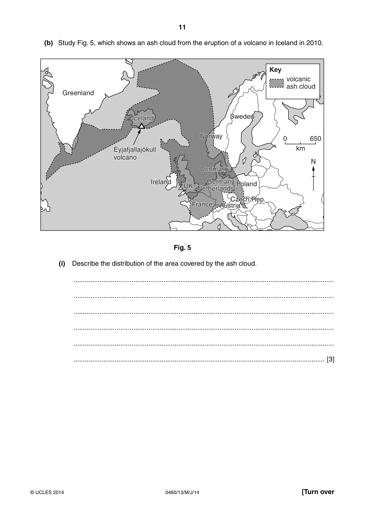
11 0460/13/M/J/14 © UCLES 2014 [Turn over (b) Study Fig. 5, which shows an ash cloud from the eruption of a volcano in Iceland in 2010. UK Ireland Ireland Norway Norway Iceland Iceland Eyjafjallajökull Sweden Sweden Greenland 650 0 km N Denmark Denmark France France Germany Germany Poland Poland Austria Austria UK Netherlands Czech Rep. volcanic ash cloud Key volcano Eyjafjallajökull volcano Fig. 5 (i) Describe the distribution of the area covered by the ash cloud. … … … … … … [3]
Question paper, page 12
12 0460/13/M/J/14 © UCLES 2014 (ii) Explain how a volcanic eruption can damage the economy of a country. … … … … … … … … … … [5]
Question paper, page 13
13 0460/13/M/J/14 © UCLES 2014 [Turn over (c) Another natural hazard is a drought. For a named area you have studied, describe the impacts of a drought. Named area … … … … … … … … … … … … … … … … [7] [Total: 25 marks] END OF QUESTION 3
Question paper, page 14
14 0460/13/M/J/14 © UCLES 2014 QUESTION 4 4 (a) Study Photograph C (Insert), which shows a river and its valley. (i) Give one difference between the vegetation on the flood plain and the vegetation on the valley side. … … [1] (ii) Name two processes of river erosion which may take place in the area shown in Photograph C. 1 … 2 … [2] (iii) Draw and label a cross section along the line P–Q which is drawn on Photograph C to show: the likely differences in the depth of the channel; a slip off slope; a river cliff. [3]
Question paper, page 15
15 0460/13/M/J/14 © UCLES 2014 [Turn over (iv) Explain how a meander might become an oxbow lake. You may use a diagram or series of diagrams. … … … … … … … … [4]
Question paper, page 16
16 0460/13/M/J/14 © UCLES 2014 (b) Study Figs 6A and 6B, maps of two deltas. N Niger sea 200 km 0 N Mississippi sea 100 km 0 Fig. 6A Fig. 6B (i) Using only evidence from Figs 6A and 6B, compare the deltas of the Niger and Mississippi. … … … … … … [3]
Question paper, page 17
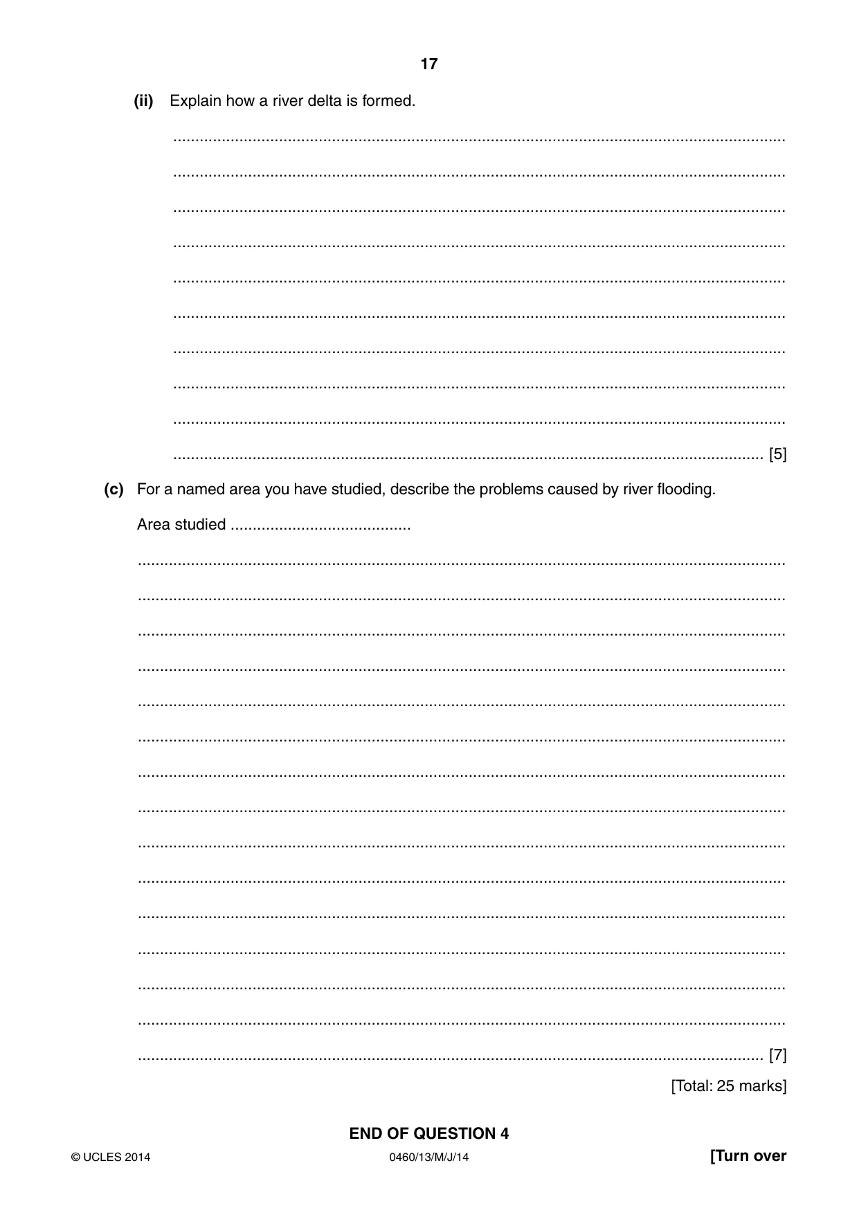
17 0460/13/M/J/14 © UCLES 2014 [Turn over (ii) Explain how a river delta is formed. … … … … … … … … … … [5] (c) For a named area you have studied, describe the problems caused by river flooding. Area studied … … … … … … … … … … … … … … … … [7] [Total: 25 marks] END OF QUESTION 4
Question paper, page 18
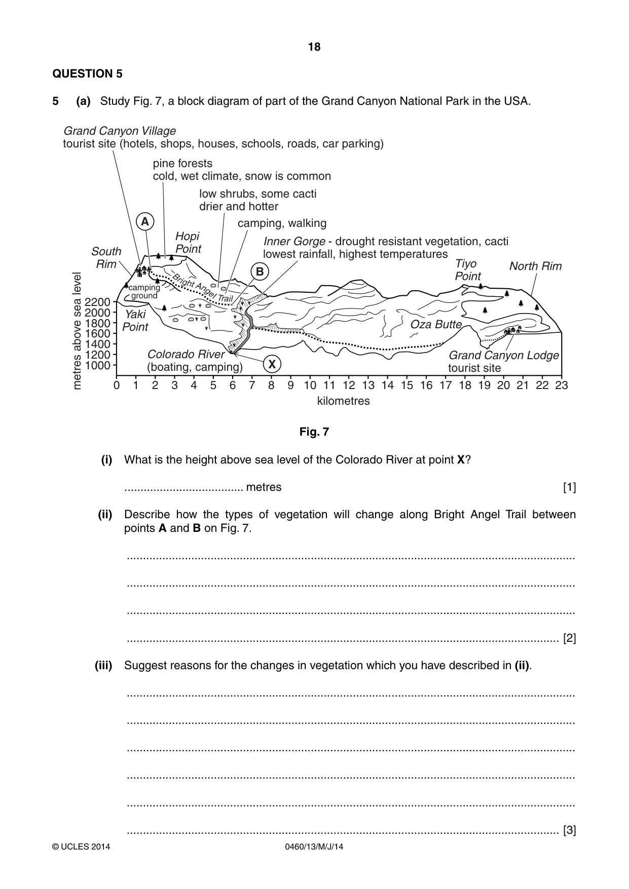
18 0460/13/M/J/14 © UCLES 2014 QUESTION 5 5 (a) Study Fig. 7, a block diagram of part of the Grand Canyon National Park in the USA. B r i g ht A n ge l T r ai l North Rim Grand Canyon Lodge tourist site Colorado River (boating, camping) Tiyo Point Oza Butte Hopi Point Yaki Point 23 22 21 20 19 18 17 16 15 14 13 12 kilometres metres above sea level X 2200 pine forests cold, wet climate, snow is common low shrubs, some cacti drier and hotter camping, walking Inner Gorge - drought resistant vegetation, cacti lowest rainfall, highest temperatures South Rim Grand Canyon Village tourist site (hotels, shops, houses, schools, roads, car parking) 2000 1800 1600 1400 1200 1000 11 10 9 8 7 6 5 4 3 2 1 0 B A camping ground Fig. 7 (i) What is the height above sea level of the Colorado River at point X? … metres [1] (ii) Describe how the types of vegetation will change along Bright Angel Trail between points A and B on Fig. 7. … … … … [2] (iii) Suggest reasons for the changes in vegetation which you have described in (ii). … … … … … … [3]
Question paper, page 19
19 0460/13/M/J/14 © UCLES 2014 [Turn over (b) Study Photographs D and E (Insert) along with Fig. 7, which show the Grand Canyon National Park. (i) Describe three features of the area shown in Photographs D and E. 1 … … 2 … … 3 … … [3] (ii) Suggest possible impacts of tourism on the natural environment of the Grand Canyon National Park. … … … … … … … … [4] (iii) Explain how creating a National Park helps to maintain, conserve or improve the quality of the natural environment. … … … … … … … … … … [5]
Question paper, page 20
20 0460/13/M/J/14 © UCLES 2014 (c) For a named area you have studied, describe the benefits and problems of tourism for local people. Name of area … … … … … … … … … … … … … … … [7] [Total: 25 marks] END OF QUESTION 5
Question paper, page 21
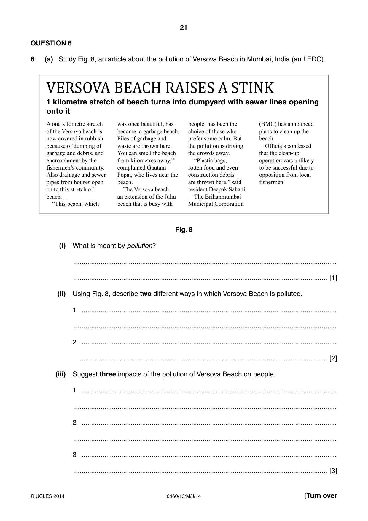
21 0460/13/M/J/14 © UCLES 2014 [Turn over QUESTION 6 6 (a) Study Fig. 8, an article about the pollution of Versova Beach in Mumbai, India (an LEDC). VERSOVA BEACH RAISES A STINK 1 kilometre stretch of beach turns into dumpyard with sewer lines opening onto it A one kilometre stretch of the Versova beach is now covered in rubbish because of dumping of garbage and debris, and encroachment by the fishermen’s community. Also drainage and sewer pipes from houses open on to this stretch of beach. “This beach, which was once beautiful, has become a garbage beach. Piles of garbage and waste are thrown here. You can smell the beach from kilometres away,” complained Gautam Popat, who lives near the beach. The Versova beach, an extension of the Juhu beach that is busy with people, has been the choice of those who prefer some calm. But the pollution is driving the crowds away. “Plastic bags, rotten food and even construction debris are thrown here,” said resident Deepak Sahani. The Brihanmumbai Municipal Corporation (BMC) has announced plans to clean up the beach. Officials confessed that the clean-up operation was unlikely to be successful due to opposition from local fishermen. Fig. 8 (i) What is meant by pollution? … … [1] (ii) Using Fig. 8, describe two different ways in which Versova Beach is polluted. 1 … … 2 … … [2] (iii) Suggest three impacts of the pollution of Versova Beach on people. 1 … … 2 … … 3 … … [3]
Question paper, page 22
22 0460/13/M/J/14 © UCLES 2014 (iv) Explain how pollution of beaches, such as Versova Beach, can affect the natural environment. … … … … … … … … [4] (b) Study Photograph F (Insert), which shows homes of fishermen on Versova Beach. (i) Describe three features of the homes shown in Photograph F. 1 … … 2 … … 3 … … [3]
Question paper, page 23
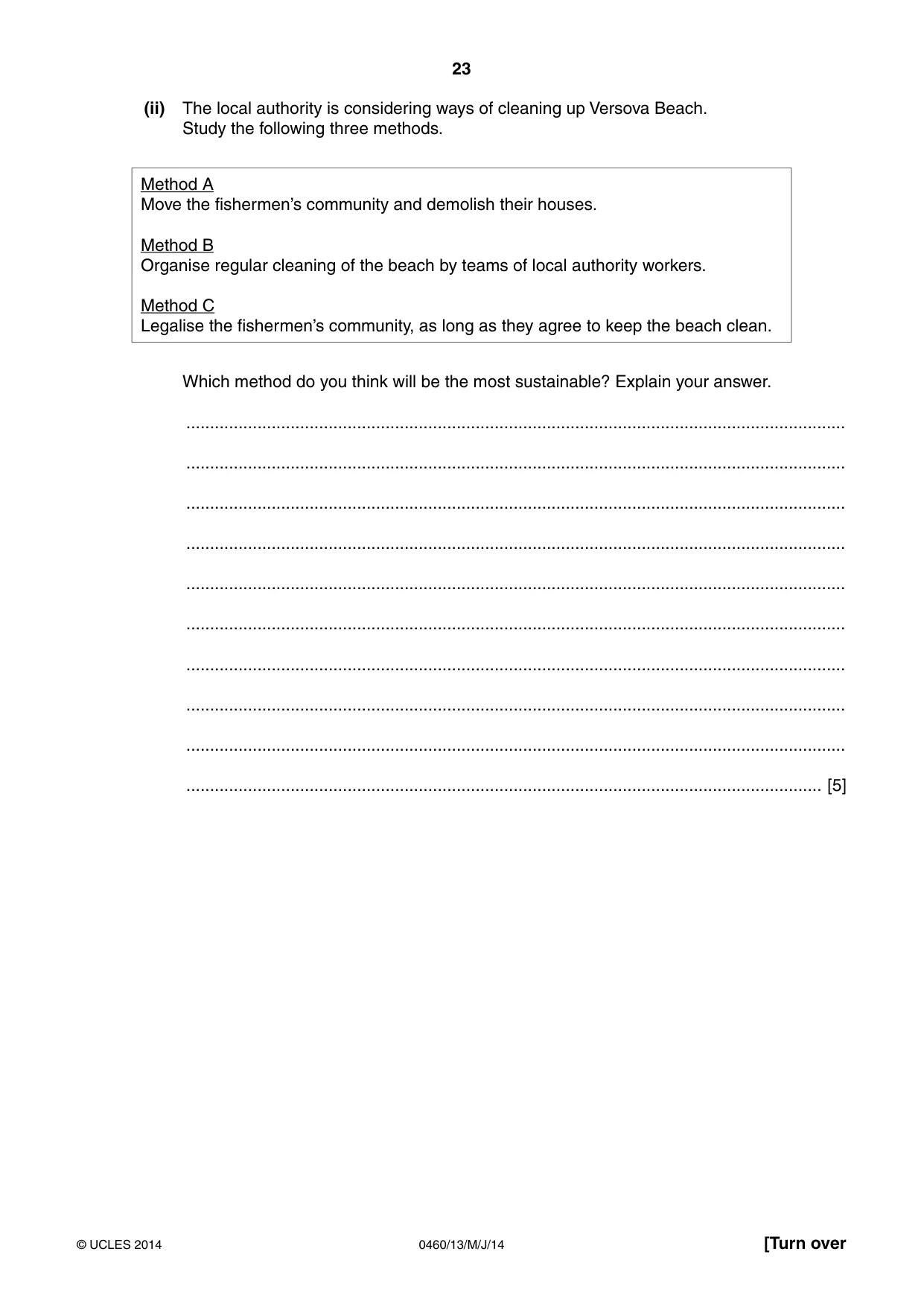
23 0460/13/M/J/14 © UCLES 2014 [Turn over (ii) The local authority is considering ways of cleaning up Versova Beach. Study the following three methods. Method A Move the fishermen’s community and demolish their houses. Method B Organise regular cleaning of the beach by teams of local authority workers. Method C Legalise the fishermen’s community, as long as they agree to keep the beach clean. Which method do you think will be the most sustainable? Explain your answer. … … … … … … … … … … [5]
Question paper, page 24
24 0460/13/M/J/14 © UCLES 2014 (c) For a named area you have studied, describe the causes and impacts of air pollution. Name of area … … … … … … … … … … … … … … … … [7] [Total: 25 marks] END OF QUESTION 6
Question paper, page 25
25 0460/13/M/J/14 © UCLES 2014 Additional Page If you use the following lined page to complete the answer(s) to any question(s), the question number(s) must be clearly shown. … … … … … … … … … … … … … … … … … … … … … … … … … …
Question paper, page 26
26 0460/13/M/J/14 © UCLES 2014 BLANK PAGE
Question paper, page 27
27 0460/13/M/J/14 © UCLES 2014 BLANK PAGE
Question paper, page 28
28 0460/13/M/J/14 © UCLES 2014 BLANK PAGE Copyright Acknowledgements: Question 1 Fig. 1 © http://option.canada.pagesperso-orange.fr/immigration_multi.htm Question 1 Fig. 2 © http://www12.statcan.ca/census-recensement/2006/as-sa/97-557/figures/c2-eng.cfm Photographs A–F S. Sibley © UCLES. Question 2 Fig. 3 © GCSE Geography; Unit 4 Topic 5; National Extension College. Question 3 Fig. 4 © http://www.fs.fed.us/pnw/mtsthelens/maps/ Question 3 Fig. 5 Adapted from: © http://news.bbc.co.uk/1/hi/8685913.stm Question 4 Figs. 6A and 6B © Jane Ferretti and Brian Greasley; GCSE Geography Exam Revision Notes; p. 20; Phillip Allan Updates; 2001; ISBN 0860034410. Question 6 Fig. 8 © http://www.dnaindia.com/mumbai/1605867/report-versova-beach-raises-a-stink Permission to reproduce items where third-party owned material protected by copyright is included has been sought and cleared where possible. Every reasonable effort has been made by the publisher (UCLES) to trace copyright holders, but if any items requiring clearance have unwittingly been included, the publisher will be pleased to make amends at the earliest possible opportunity. Cambridge International Examinations is part of the Cambridge Assessment Group. Cambridge Assessment is the brand name of University of Cambridge Local Examinations Syndicate (UCLES), which is itself a department of the University of Cambridge.
Mark scheme, page 1
CAMBRIDGE INTERNATIONAL EXAMINATIONS International General Certificate of Secondary Education MARK SCHEME for the May/June 2014 series 0460 GEOGRAPHY 0460/13 Paper 1, maximum raw mark 75 This mark scheme is published as an aid to teachers and candidates, to indicate the requirements of the examination. It shows the basis on which Examiners were instructed to award marks. It does not indicate the details of the discussions that took place at an Examiners’ meeting before marking began, which would have considered the acceptability of alternative answers. Mark schemes should be read in conjunction with the question paper and the Principal Examiner Report for Teachers. Cambridge will not enter into discussions about these mark schemes. Cambridge is publishing the mark schemes for the May/June 2014 series for most IGCSE, GCE Advanced Level and Advanced Subsidiary Level components and some Ordinary Level components.
Mark scheme, page 2
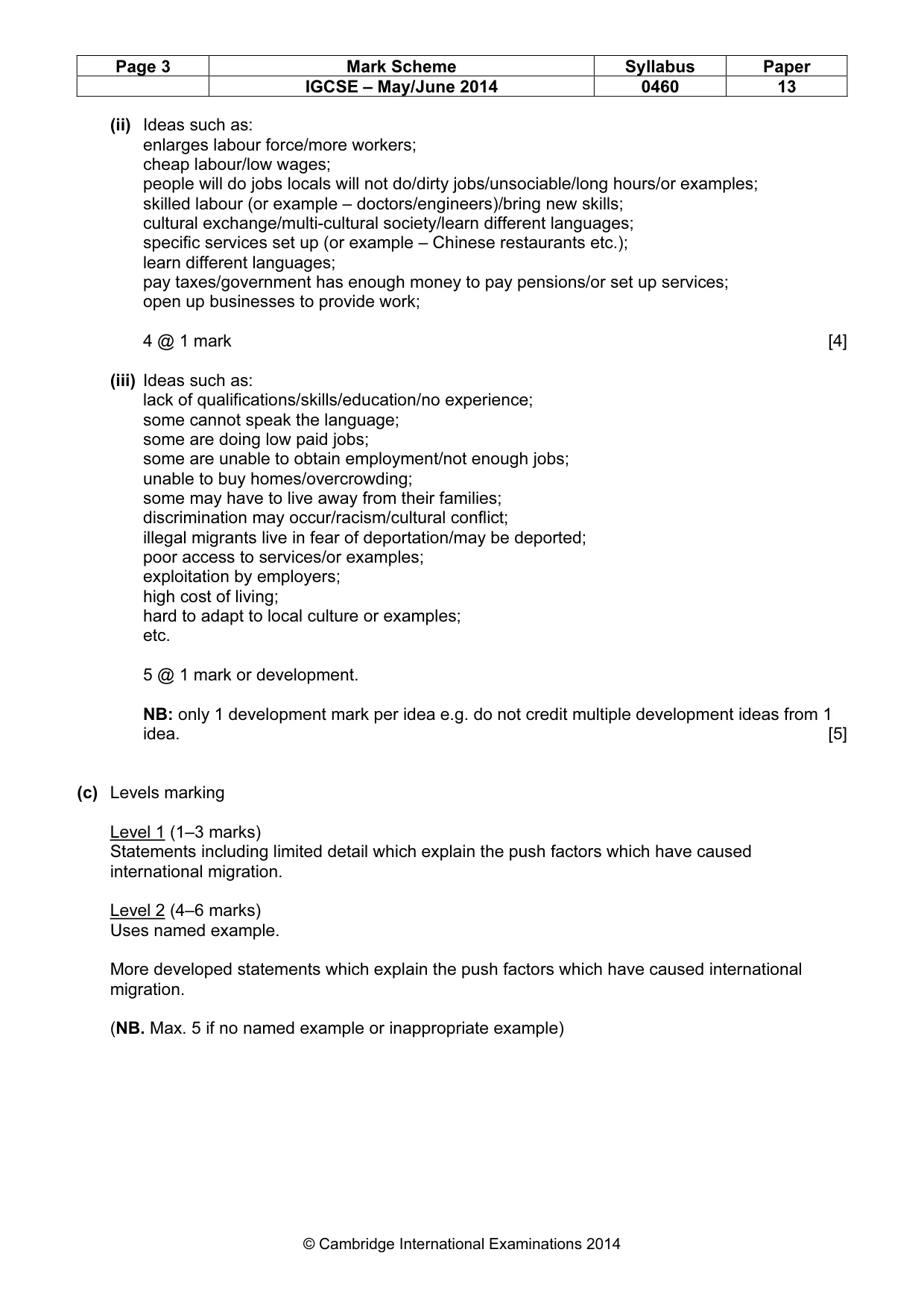
Page 2 Mark Scheme Syllabus Paper IGCSE – May/June 2014 0460 13 © Cambridge International Examinations 2014 1 (a) (i) Immigration/250,000 immigrants per year/due to migration into Canada; 1 mark [1] (ii) Ideas such as: employment/jobs/high pay; entertainments/bright lights (or example); education/schools/colleges/universities; health care/doctors/clinics; brick built housing/housing with electricity/running water/toilets; etc. 2 @ 1 mark [2] (iii) Ideas such as: availability of contraception/family planning; can afford contraception/family planning; educated how to use contraceptives; availability of abortions; women have careers; education/emancipation of women; high cost of children; lack of religious influences; later marriages; low infant mortality rate; look after them in old age/have pensions; etc. 3 @ 1 mark [3] (b) (i) By 2006 there were: a greater percentage/increased from Asia/lower percentage in Asia in 1971; lower percentage from Europe; a greater percentage from Africa; lower percentage from United States; lower percentage from Oceania; 1971 most came from Europe but in 2006 most came from Asia idea max 1. Less from MEDC’s in 2006/more from LEDC’s in 2006; NB: Must have comparison. No marks for statistics without interpretation. Can accept converse in each line. 3 @ 1 mark [3]
Mark scheme, page 3
Page 3 Mark Scheme Syllabus Paper IGCSE – May/June 2014 0460 13 © Cambridge International Examinations 2014 (ii) Ideas such as: enlarges labour force/more workers; cheap labour/low wages; people will do jobs locals will not do/dirty jobs/unsociable/long hours/or examples; skilled labour (or example – doctors/engineers)/bring new skills; cultural exchange/multi-cultural society/learn different languages; specific services set up (or example – Chinese restaurants etc.); learn different languages; pay taxes/government has enough money to pay pensions/or set up services; open up businesses to provide work; 4 @ 1 mark [4] (iii) Ideas such as: lack of qualifications/skills/education/no experience; some cannot speak the language; some are doing low paid jobs; some are unable to obtain employment/not enough jobs; unable to buy homes/overcrowding; some may have to live away from their families; discrimination may occur/racism/cultural conflict; illegal migrants live in fear of deportation/may be deported; poor access to services/or examples; exploitation by employers; high cost of living; hard to adapt to local culture or examples; etc. 5 @ 1 mark or development. NB: only 1 development mark per idea e.g. do not credit multiple development ideas from 1 idea. [5] (c) Levels marking Level 1 (1–3 marks) Statements including limited detail which explain the push factors which have caused international migration. Level 2 (4–6 marks) Uses named example. More developed statements which explain the push factors which have caused international migration. (NB. Max. 5 if no named example or inappropriate example)
Mark scheme, page 4
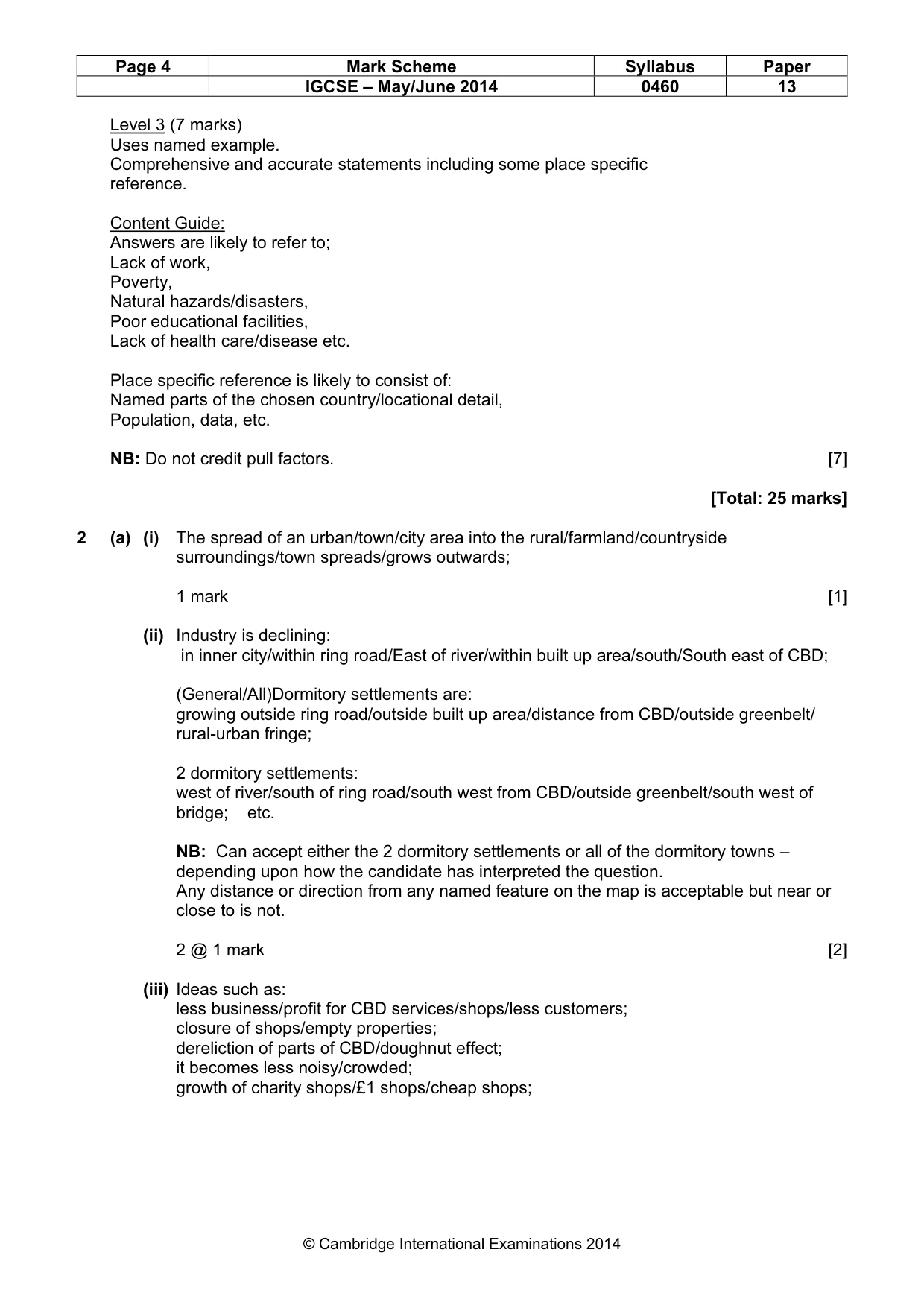
Page 4 Mark Scheme Syllabus Paper IGCSE – May/June 2014 0460 13 © Cambridge International Examinations 2014 Level 3 (7 marks) Uses named example. Comprehensive and accurate statements including some place specific reference. Content Guide: Answers are likely to refer to; Lack of work, Poverty, Natural hazards/disasters, Poor educational facilities, Lack of health care/disease etc. Place specific reference is likely to consist of: Named parts of the chosen country/locational detail, Population, data, etc. NB: Do not credit pull factors. [7] [Total: 25 marks] 2 (a) (i) The spread of an urban/town/city area into the rural/farmland/countryside surroundings/town spreads/grows outwards; 1 mark [1] (ii) Industry is declining: in inner city/within ring road/East of river/within built up area/south/South east of CBD; (General/All)Dormitory settlements are: growing outside ring road/outside built up area/distance from CBD/outside greenbelt/ rural-urban fringe; 2 dormitory settlements: west of river/south of ring road/south west from CBD/outside greenbelt/south west of bridge; etc. NB: Can accept either the 2 dormitory settlements or all of the dormitory towns – depending upon how the candidate has interpreted the question. Any distance or direction from any named feature on the map is acceptable but near or close to is not. 2 @ 1 mark [2] (iii) Ideas such as: less business/profit for CBD services/shops/less customers; closure of shops/empty properties; dereliction of parts of CBD/doughnut effect; it becomes less noisy/crowded; growth of charity shops/£1 shops/cheap shops;
Mark scheme, page 5
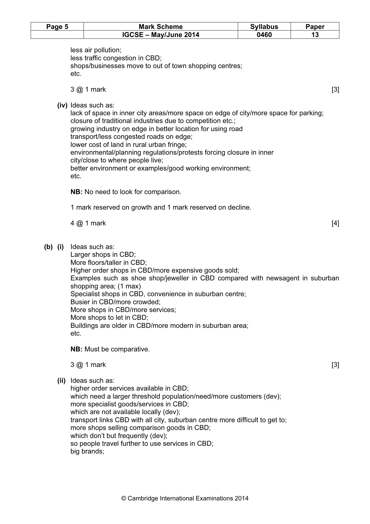
Page 5 Mark Scheme Syllabus Paper IGCSE – May/June 2014 0460 13 © Cambridge International Examinations 2014 less air pollution; less traffic congestion in CBD; shops/businesses move to out of town shopping centres; etc. 3 @ 1 mark [3] (iv) Ideas such as: lack of space in inner city areas/more space on edge of city/more space for parking; closure of traditional industries due to competition etc.; growing industry on edge in better location for using road transport/less congested roads on edge; lower cost of land in rural urban fringe; environmental/planning regulations/protests forcing closure in inner city/close to where people live; better environment or examples/good working environment; etc. NB: No need to look for comparison. 1 mark reserved on growth and 1 mark reserved on decline. 4 @ 1 mark [4] (b) (i) Ideas such as: Larger shops in CBD; More floors/taller in CBD; Higher order shops in CBD/more expensive goods sold; Examples such as shoe shop/jeweller in CBD compared with newsagent in suburban shopping area; (1 max) Specialist shops in CBD, convenience in suburban centre; Busier in CBD/more crowded; More shops in CBD/more services; More shops to let in CBD; Buildings are older in CBD/more modern in suburban area; etc. NB: Must be comparative. 3 @ 1 mark [3] (ii) Ideas such as: higher order services available in CBD; which need a larger threshold population/need/more customers (dev); more specialist goods/services in CBD; which are not available locally (dev); transport links CBD with all city, suburban centre more difficult to get to; more shops selling comparison goods in CBD; which don’t but frequently (dev); so people travel further to use services in CBD; big brands;
Mark scheme, page 6
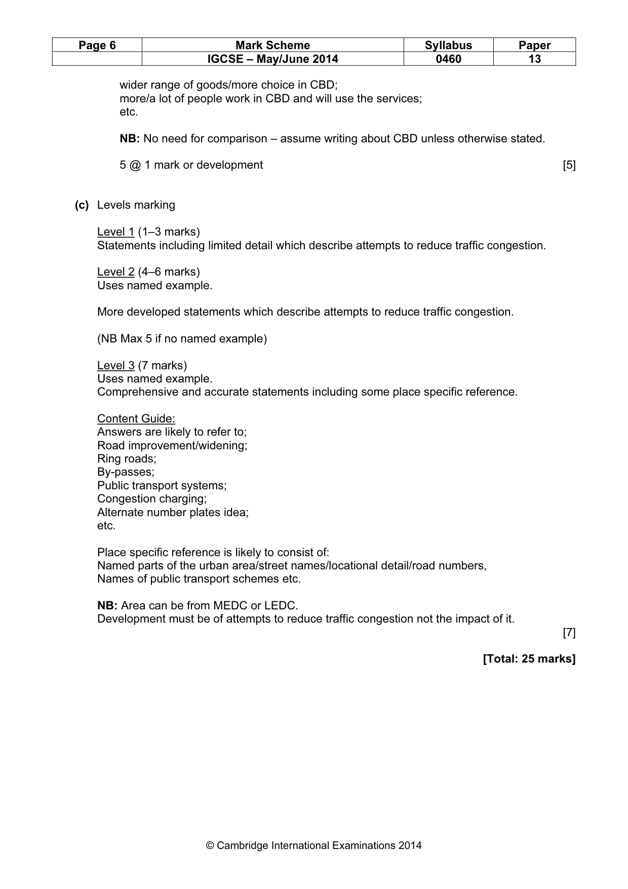
Page 6 Mark Scheme Syllabus Paper IGCSE – May/June 2014 0460 13 © Cambridge International Examinations 2014 wider range of goods/more choice in CBD; more/a lot of people work in CBD and will use the services; etc. NB: No need for comparison – assume writing about CBD unless otherwise stated. 5 @ 1 mark or development [5] (c) Levels marking Level 1 (1–3 marks) Statements including limited detail which describe attempts to reduce traffic congestion. Level 2 (4–6 marks) Uses named example. More developed statements which describe attempts to reduce traffic congestion. (NB Max 5 if no named example) Level 3 (7 marks) Uses named example. Comprehensive and accurate statements including some place specific reference. Content Guide: Answers are likely to refer to; Road improvement/widening; Ring roads; By-passes; Public transport systems; Congestion charging; Alternate number plates idea; etc. Place specific reference is likely to consist of: Named parts of the urban area/street names/locational detail/road numbers, Names of public transport schemes etc. NB: Area can be from MEDC or LEDC. Development must be of attempts to reduce traffic congestion not the impact of it. [7] [Total: 25 marks]
Mark scheme, page 7
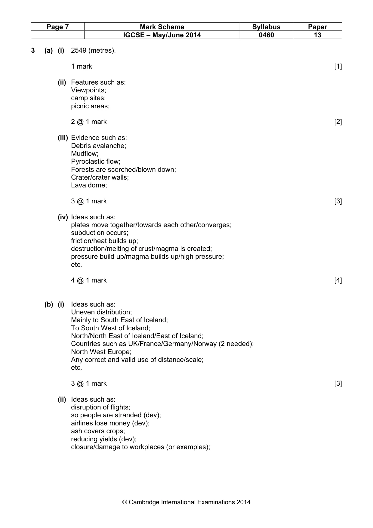
Page 7 Mark Scheme Syllabus Paper IGCSE – May/June 2014 0460 13 © Cambridge International Examinations 2014 3 (a) (i) 2549 (metres). 1 mark [1] (ii) Features such as: Viewpoints; camp sites; picnic areas; 2 @ 1 mark [2] (iii) Evidence such as: Debris avalanche; Mudflow; Pyroclastic flow; Forests are scorched/blown down; Crater/crater walls; Lava dome; 3 @ 1 mark [3] (iv) Ideas such as: plates move together/towards each other/converges; subduction occurs; friction/heat builds up; destruction/melting of crust/magma is created; pressure build up/magma builds up/high pressure; etc. 4 @ 1 mark [4] (b) (i) Ideas such as: Uneven distribution; Mainly to South East of Iceland; To South West of Iceland; North/North East of Iceland/East of Iceland; Countries such as UK/France/Germany/Norway (2 needed); North West Europe; Any correct and valid use of distance/scale; etc. 3 @ 1 mark [3] (ii) Ideas such as: disruption of flights; so people are stranded (dev); airlines lose money (dev); ash covers crops; reducing yields (dev); closure/damage to workplaces (or examples);
Mark scheme, page 8
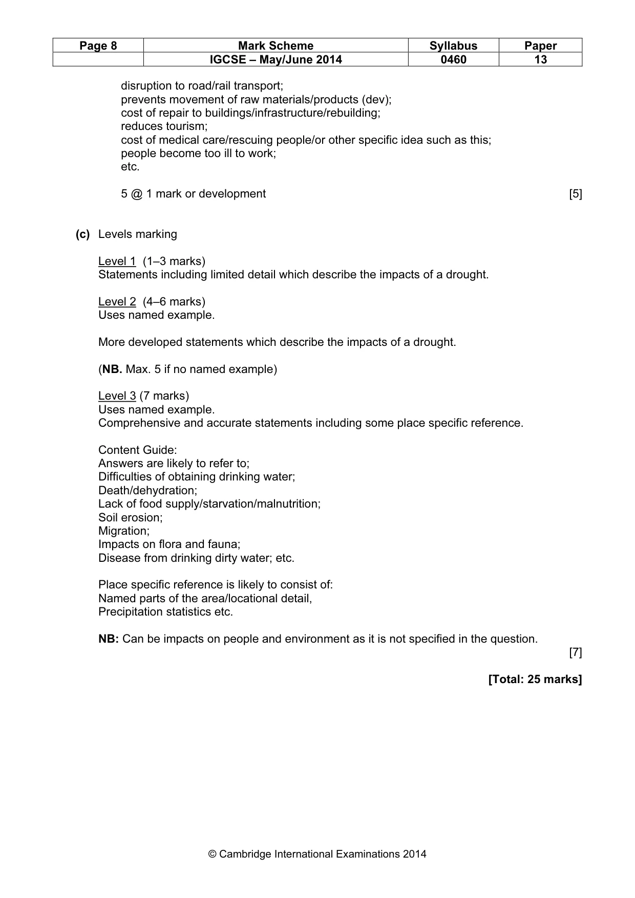
Page 8 Mark Scheme Syllabus Paper IGCSE – May/June 2014 0460 13 © Cambridge International Examinations 2014 disruption to road/rail transport; prevents movement of raw materials/products (dev); cost of repair to buildings/infrastructure/rebuilding; reduces tourism; cost of medical care/rescuing people/or other specific idea such as this; people become too ill to work; etc. 5 @ 1 mark or development [5] (c) Levels marking Level 1 (1–3 marks) Statements including limited detail which describe the impacts of a drought. Level 2 (4–6 marks) Uses named example. More developed statements which describe the impacts of a drought. (NB. Max. 5 if no named example) Level 3 (7 marks) Uses named example. Comprehensive and accurate statements including some place specific reference. Content Guide: Answers are likely to refer to; Difficulties of obtaining drinking water; Death/dehydration; Lack of food supply/starvation/malnutrition; Soil erosion; Migration; Impacts on flora and fauna; Disease from drinking dirty water; etc. Place specific reference is likely to consist of: Named parts of the area/locational detail, Precipitation statistics etc. NB: Can be impacts on people and environment as it is not specified in the question. [7] [Total: 25 marks]
Mark scheme, page 9
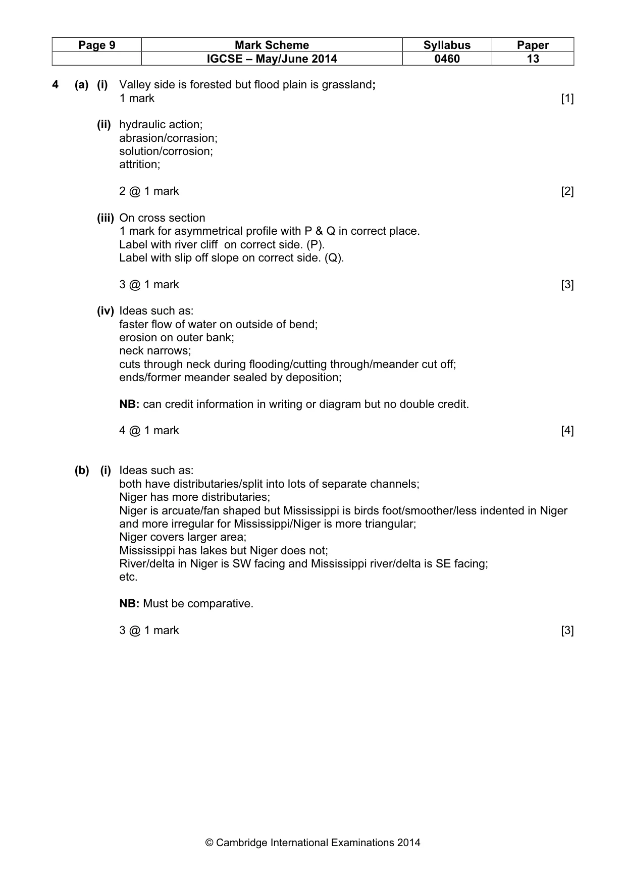
Page 9 Mark Scheme Syllabus Paper IGCSE – May/June 2014 0460 13 © Cambridge International Examinations 2014 4 (a) (i) Valley side is forested but flood plain is grassland; 1 mark [1] (ii) hydraulic action; abrasion/corrasion; solution/corrosion; attrition; 2 @ 1 mark [2] (iii) On cross section 1 mark for asymmetrical profile with P & Q in correct place. Label with river cliff on correct side. (P). Label with slip off slope on correct side. (Q). 3 @ 1 mark [3] (iv) Ideas such as: faster flow of water on outside of bend; erosion on outer bank; neck narrows; cuts through neck during flooding/cutting through/meander cut off; ends/former meander sealed by deposition; NB: can credit information in writing or diagram but no double credit. 4 @ 1 mark [4] (b) (i) Ideas such as: both have distributaries/split into lots of separate channels; Niger has more distributaries; Niger is arcuate/fan shaped but Mississippi is birds foot/smoother/less indented in Niger and more irregular for Mississippi/Niger is more triangular; Niger covers larger area; Mississippi has lakes but Niger does not; River/delta in Niger is SW facing and Mississippi river/delta is SE facing; etc. NB: Must be comparative. 3 @ 1 mark [3]
Mark scheme, page 10
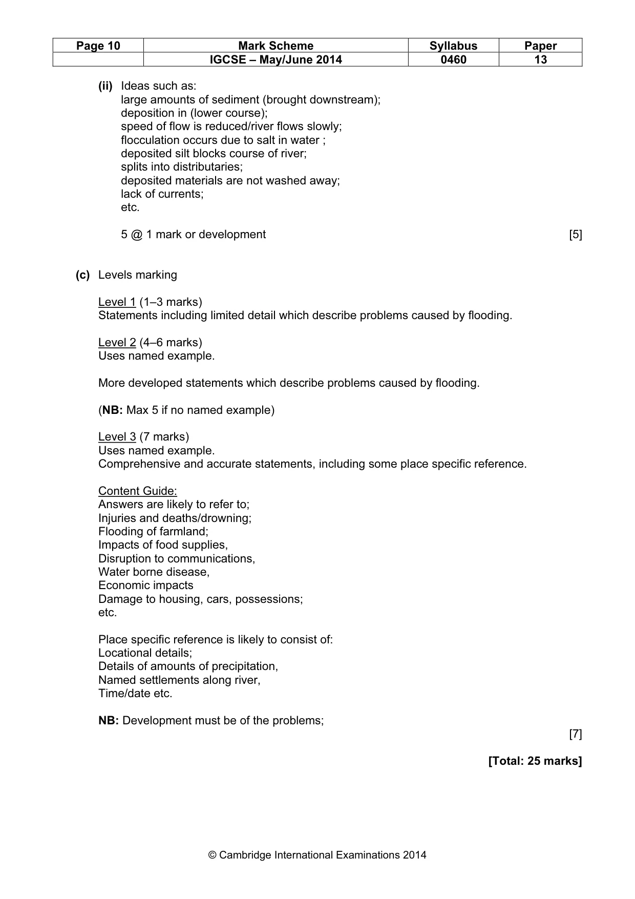
Page 10 Mark Scheme Syllabus Paper IGCSE – May/June 2014 0460 13 © Cambridge International Examinations 2014 (ii) Ideas such as: large amounts of sediment (brought downstream); deposition in (lower course); speed of flow is reduced/river flows slowly; flocculation occurs due to salt in water ; deposited silt blocks course of river; splits into distributaries; deposited materials are not washed away; lack of currents; etc. 5 @ 1 mark or development [5] (c) Levels marking Level 1 (1–3 marks) Statements including limited detail which describe problems caused by flooding. Level 2 (4–6 marks) Uses named example. More developed statements which describe problems caused by flooding. (NB: Max 5 if no named example) Level 3 (7 marks) Uses named example. Comprehensive and accurate statements, including some place specific reference. Content Guide: Answers are likely to refer to; Injuries and deaths/drowning; Flooding of farmland; Impacts of food supplies, Disruption to communications, Water borne disease, Economic impacts Damage to housing, cars, possessions; etc. Place specific reference is likely to consist of: Locational details; Details of amounts of precipitation, Named settlements along river, Time/date etc. NB: Development must be of the problems; [7] [Total: 25 marks]
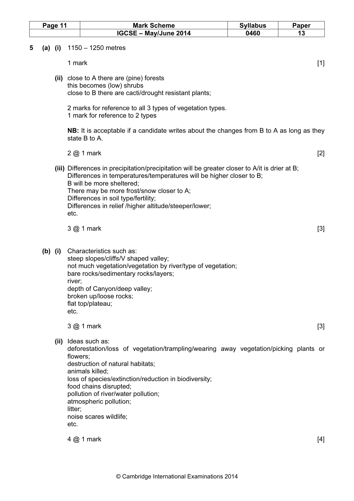
Mark scheme, page 11
Page 11 Mark Scheme Syllabus Paper IGCSE – May/June 2014 0460 13 © Cambridge International Examinations 2014 5 (a) (i) 1150 – 1250 metres 1 mark [1] (ii) close to A there are (pine) forests this becomes (low) shrubs close to B there are cacti/drought resistant plants; 2 marks for reference to all 3 types of vegetation types. 1 mark for reference to 2 types NB: It is acceptable if a candidate writes about the changes from B to A as long as they state B to A. 2 @ 1 mark [2] (iii) Differences in precipitation/precipitation will be greater closer to A/it is drier at B; Differences in temperatures/temperatures will be higher closer to B; B will be more sheltered; There may be more frost/snow closer to A; Differences in soil type/fertility; Differences in relief /higher altitude/steeper/lower; etc. 3 @ 1 mark [3] (b) (i) Characteristics such as: steep slopes/cliffs/V shaped valley; not much vegetation/vegetation by river/type of vegetation; bare rocks/sedimentary rocks/layers; river; depth of Canyon/deep valley; broken up/loose rocks; flat top/plateau; etc. 3 @ 1 mark [3] (ii) Ideas such as: deforestation/loss of vegetation/trampling/wearing away vegetation/picking plants or flowers; destruction of natural habitats; animals killed; loss of species/extinction/reduction in biodiversity; food chains disrupted; pollution of river/water pollution; atmospheric pollution; litter; noise scares wildlife; etc. 4 @ 1 mark [4]
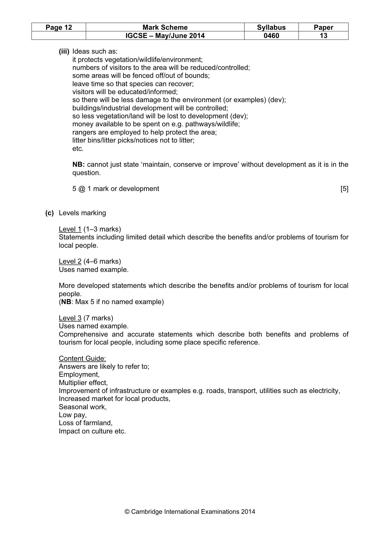
Mark scheme, page 12
Page 12 Mark Scheme Syllabus Paper IGCSE – May/June 2014 0460 13 © Cambridge International Examinations 2014 (iii) Ideas such as: it protects vegetation/wildlife/environment; numbers of visitors to the area will be reduced/controlled; some areas will be fenced off/out of bounds; leave time so that species can recover; visitors will be educated/informed; so there will be less damage to the environment (or examples) (dev); buildings/industrial development will be controlled; so less vegetation/land will be lost to development (dev); money available to be spent on e.g. pathways/wildlife; rangers are employed to help protect the area; litter bins/litter picks/notices not to litter; etc. NB: cannot just state ‘maintain, conserve or improve’ without development as it is in the question. 5 @ 1 mark or development [5] (c) Levels marking Level 1 (1–3 marks) Statements including limited detail which describe the benefits and/or problems of tourism for local people. Level 2 (4–6 marks) Uses named example. More developed statements which describe the benefits and/or problems of tourism for local people. (NB: Max 5 if no named example) Level 3 (7 marks) Uses named example. Comprehensive and accurate statements which describe both benefits and problems of tourism for local people, including some place specific reference. Content Guide: Answers are likely to refer to; Employment, Multiplier effect, Improvement of infrastructure or examples e.g. roads, transport, utilities such as electricity, Increased market for local products, Seasonal work, Low pay, Loss of farmland, Impact on culture etc.
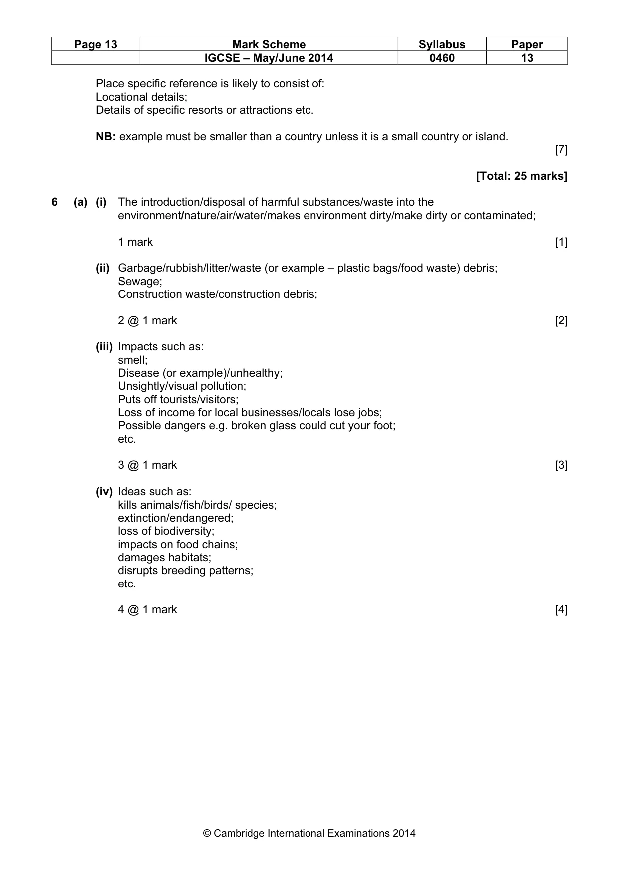
Mark scheme, page 13
Page 13 Mark Scheme Syllabus Paper IGCSE – May/June 2014 0460 13 © Cambridge International Examinations 2014 Place specific reference is likely to consist of: Locational details; Details of specific resorts or attractions etc. NB: example must be smaller than a country unless it is a small country or island. [7] [Total: 25 marks] 6 (a) (i) The introduction/disposal of harmful substances/waste into the environment/nature/air/water/makes environment dirty/make dirty or contaminated; 1 mark [1] (ii) Garbage/rubbish/litter/waste (or example – plastic bags/food waste) debris; Sewage; Construction waste/construction debris; 2 @ 1 mark [2] (iii) Impacts such as: smell; Disease (or example)/unhealthy; Unsightly/visual pollution; Puts off tourists/visitors; Loss of income for local businesses/locals lose jobs; Possible dangers e.g. broken glass could cut your foot; etc. 3 @ 1 mark [3] (iv) Ideas such as: kills animals/fish/birds/ species; extinction/endangered; loss of biodiversity; impacts on food chains; damages habitats; disrupts breeding patterns; etc. 4 @ 1 mark [4]
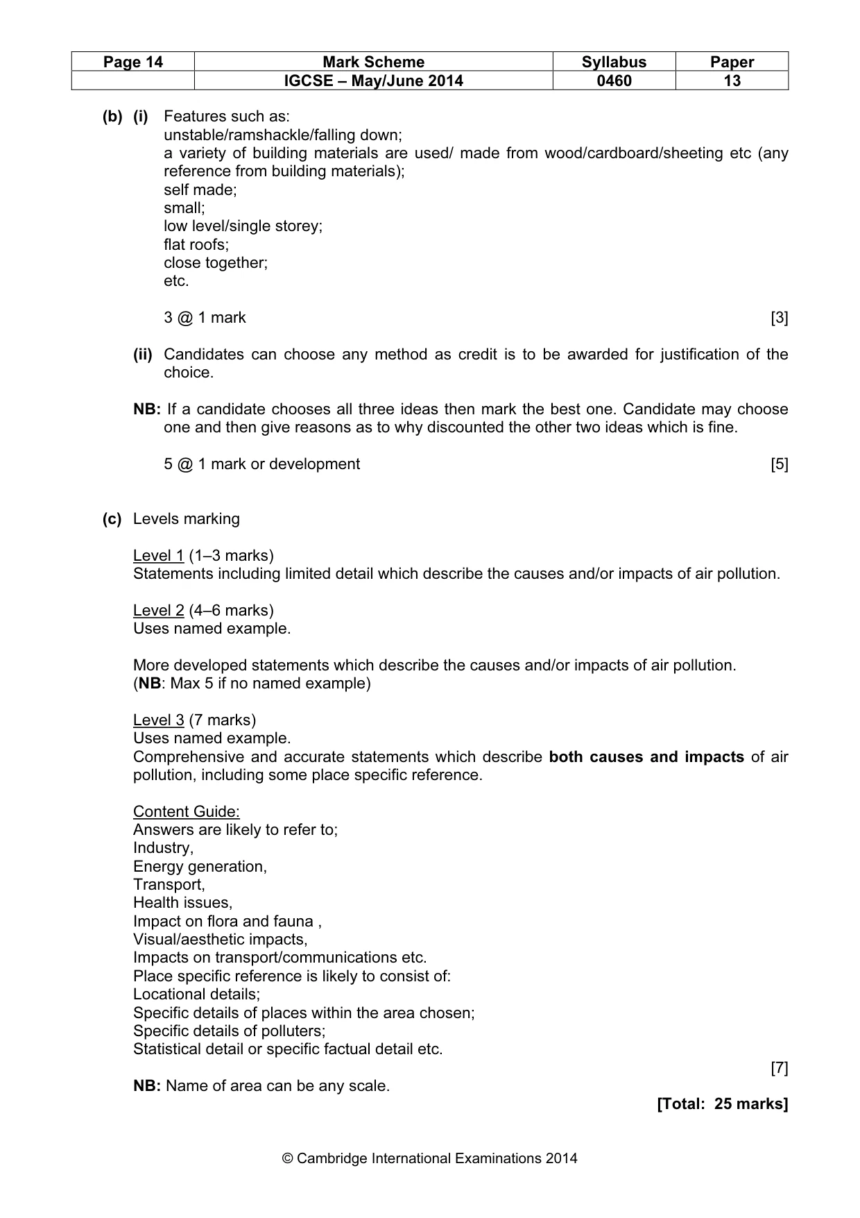
Mark scheme, page 14
Page 14 Mark Scheme Syllabus Paper IGCSE – May/June 2014 0460 13 © Cambridge International Examinations 2014 (b) (i) Features such as: unstable/ramshackle/falling down; a variety of building materials are used/ made from wood/cardboard/sheeting etc (any reference from building materials); self made; small; low level/single storey; flat roofs; close together; etc. 3 @ 1 mark [3] (ii) Candidates can choose any method as credit is to be awarded for justification of the choice. NB: If a candidate chooses all three ideas then mark the best one. Candidate may choose one and then give reasons as to why discounted the other two ideas which is fine. 5 @ 1 mark or development [5] (c) Levels marking Level 1 (1–3 marks) Statements including limited detail which describe the causes and/or impacts of air pollution. Level 2 (4–6 marks) Uses named example. More developed statements which describe the causes and/or impacts of air pollution. (NB: Max 5 if no named example) Level 3 (7 marks) Uses named example. Comprehensive and accurate statements which describe both causes and impacts of air pollution, including some place specific reference. Content Guide: Answers are likely to refer to; Industry, Energy generation, Transport, Health issues, Impact on flora and fauna , Visual/aesthetic impacts, Impacts on transport/communications etc. Place specific reference is likely to consist of: Locational details; Specific details of places within the area chosen; Specific details of polluters; Statistical detail or specific factual detail etc. [7] NB: Name of area can be any scale. [Total: 25 marks]
What you needed in this session
Cambridge’s own grade thresholds for 2014 May/June, Paper 1 · Variant 3. A higher threshold means an easier paper — the bar moves with how the cohort did.