Cambridge IGCSE Geography 0460 — 2012 May/June Paper 1 · Variant 1
0460/11/M/J/12 · 75 marks · ≈84 min
The question paper and its mark scheme, free to read here and free to download. This is Cambridge’s own paper, exactly as it was sat.
Question paper28 pages



Mark scheme13 pages
Answers below. Sit the paper first if you are practising.
Paper as text
Question paper, page 1
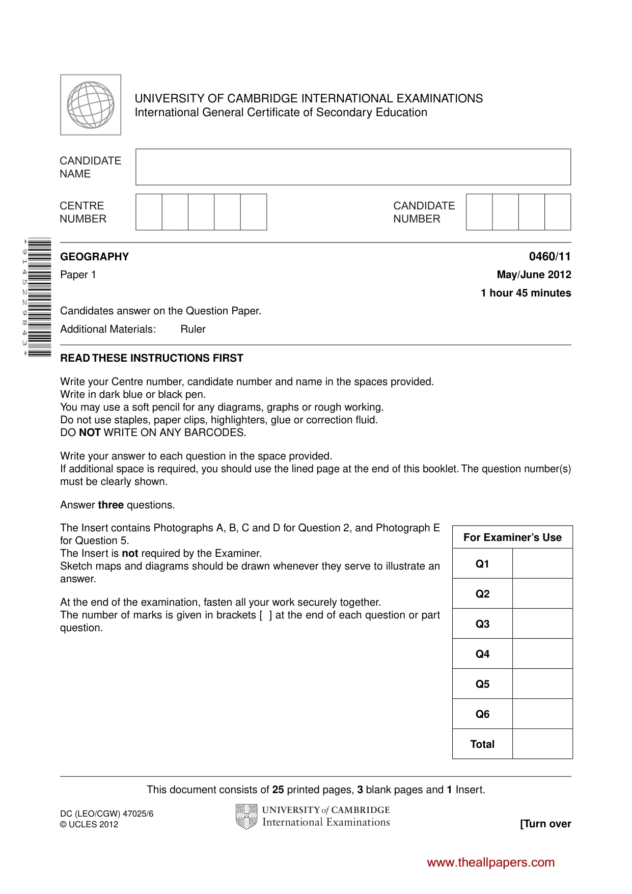
This document consists of 25 printed pages, 3 blank pages and 1 Insert. DC (LEO/CGW) 47025/6 © UCLES 2012 [Turn over UNIVERSITY OF CAMBRIDGE INTERNATIONAL EXAMINATIONS International General Certificate of Secondary Education * 9 1 4 5 2 2 9 8 4 3 * GEOGRAPHY 0460/11 Paper 1 May/June 2012 1 hour 45 minutes Candidates answer on the Question Paper. Additional Materials: Ruler READ THESE INSTRUCTIONS FIRST Write your Centre number, candidate number and name in the spaces provided. Write in dark blue or black pen. You may use a soft pencil for any diagrams, graphs or rough working. Do not use staples, paper clips, highlighters, glue or correction fluid. DO NOT WRITE ON ANY BARCODES. Write your answer to each question in the space provided. If additional space is required, you should use the lined page at the end of this booklet. The question number(s) must be clearly shown. Answer three questions. The Insert contains Photographs A, B, C and D for Question 2, and Photograph E for Question 5. The Insert is not required by the Examiner. Sketch maps and diagrams should be drawn whenever they serve to illustrate an answer. At the end of the examination, fasten all your work securely together. The number of marks is given in brackets [ ] at the end of each question or part question. For Examiner’s Use Q1 Q2 Q3 Q4 Q5 Q6 Total www.theallpapers.com
Question paper, page 2
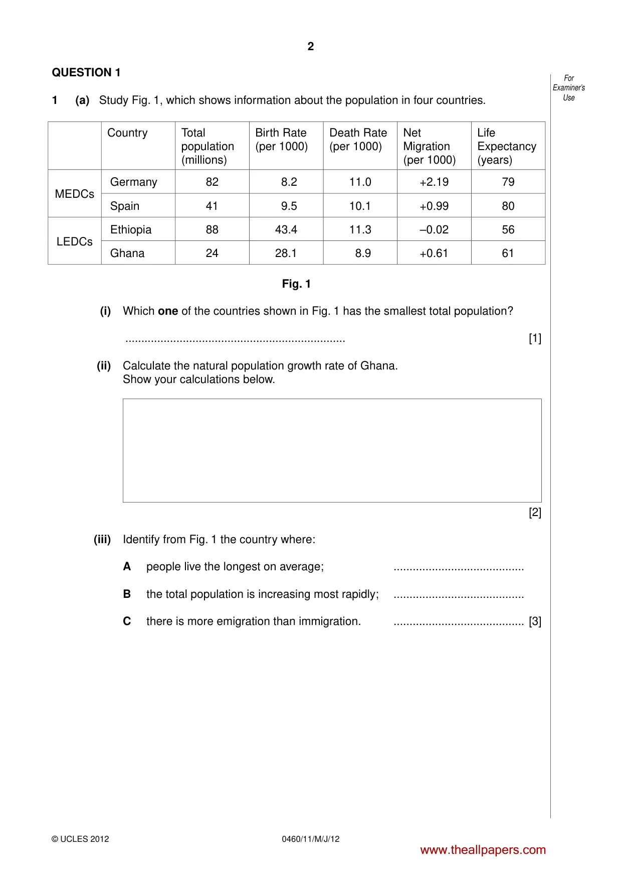
2 © UCLES 2012 0460/11/M/J/12 For Examiner’s Use QUESTION 1 1 (a) Study Fig. 1, which shows information about the population in four countries. Country Total population (millions) Birth Rate (per 1000) Death Rate (per 1000) Net Migration (per 1000) Life Expectancy (years) MEDCs Germany 82 8.2 11.0 +2.19 79 Spain 41 9.5 10.1 +0.99 80 LEDCs Ethiopia 88 43.4 11.3 –0.02 56 Ghana 24 28.1 8.9 +0.61 61 Fig. 1 (i) Which one of the countries shown in Fig. 1 has the smallest total population? … [1] (ii) Calculate the natural population growth rate of Ghana. Show your calculations below. [2] (iii) Identify from Fig. 1 the country where: A people live the longest on average; … B the total population is increasing most rapidly; … C there is more emigration than immigration. … [3] www.theallpapers.com
Question paper, page 3
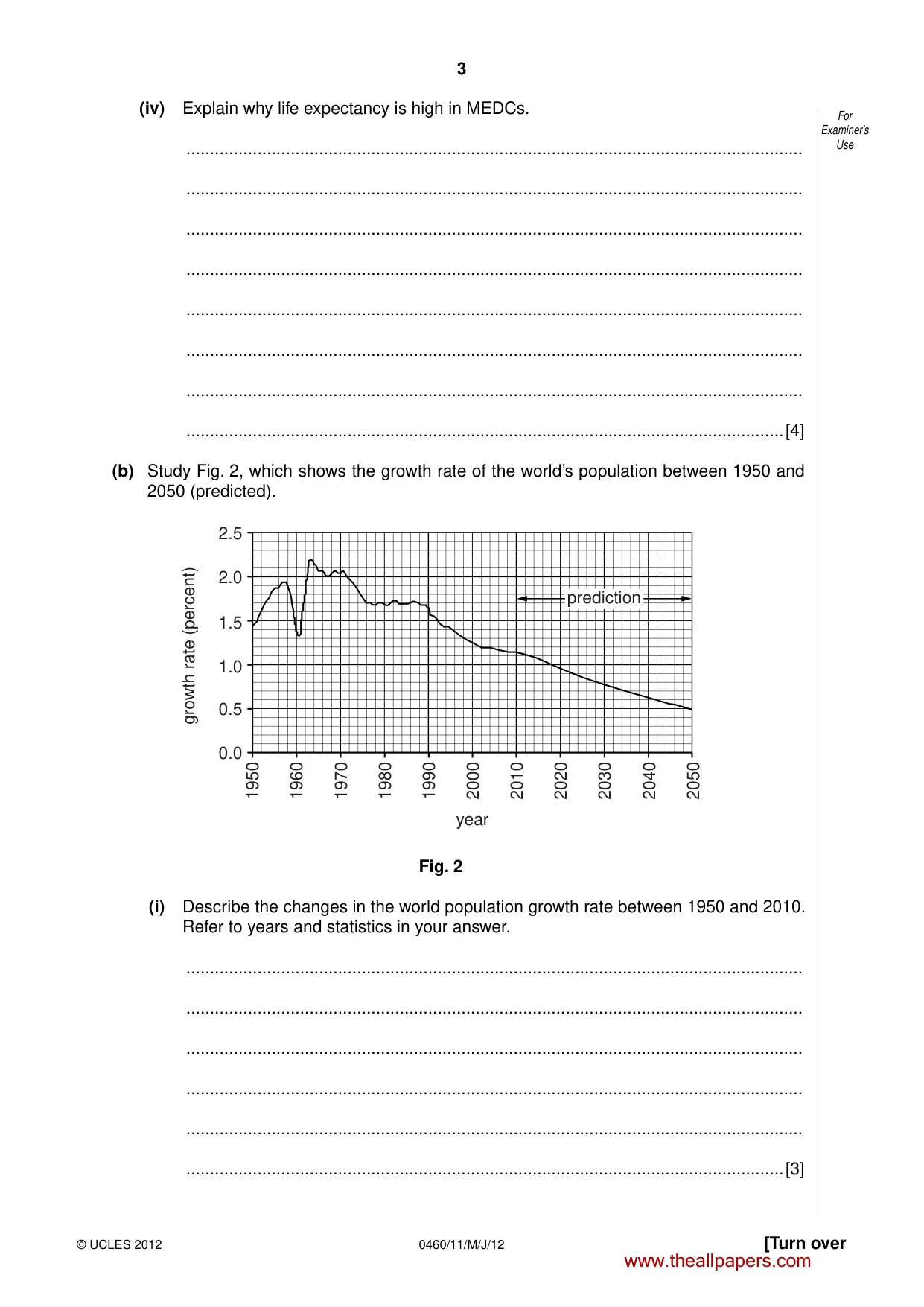
3 © UCLES 2012 [Turn over 0460/11/M/J/12 For Examiner’s Use (iv) Explain why life expectancy is high in MEDCs. … … … … … … … …[4] (b) Study Fig. 2, which shows the growth rate of the world’s population between 1950 and 2050 (predicted). growth rate (percent) 1950 1960 1970 1980 1990 2000 2010 2020 2030 2040 2050 2.5 2.0 1.5 1.0 0.5 0.0 year prediction Fig. 2 (i) Describe the changes in the world population growth rate between 1950 and 2010. Refer to years and statistics in your answer. … … … … … …[3] www.theallpapers.com
Question paper, page 4
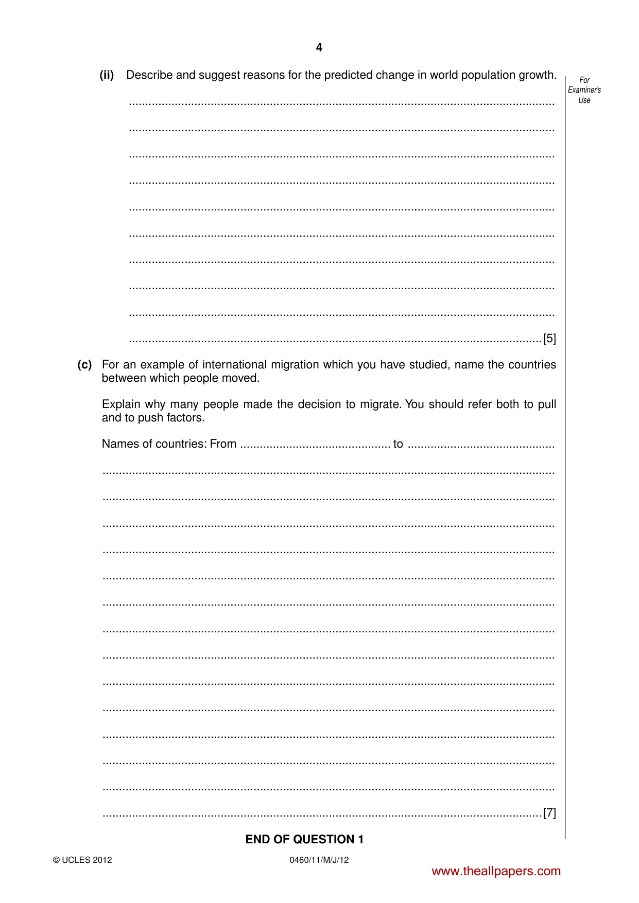
4 © UCLES 2012 0460/11/M/J/12 For Examiner’s Use (ii) Describe and suggest reasons for the predicted change in world population growth. … … … … … … … … … …[5] (c) For an example of international migration which you have studied, name the countries between which people moved. Explain why many people made the decision to migrate. You should refer both to pull and to push factors. Names of countries: From … to … … … … … … … … … … … … … … …[7] END OF QUESTION 1 www.theallpapers.com
Question paper, page 5
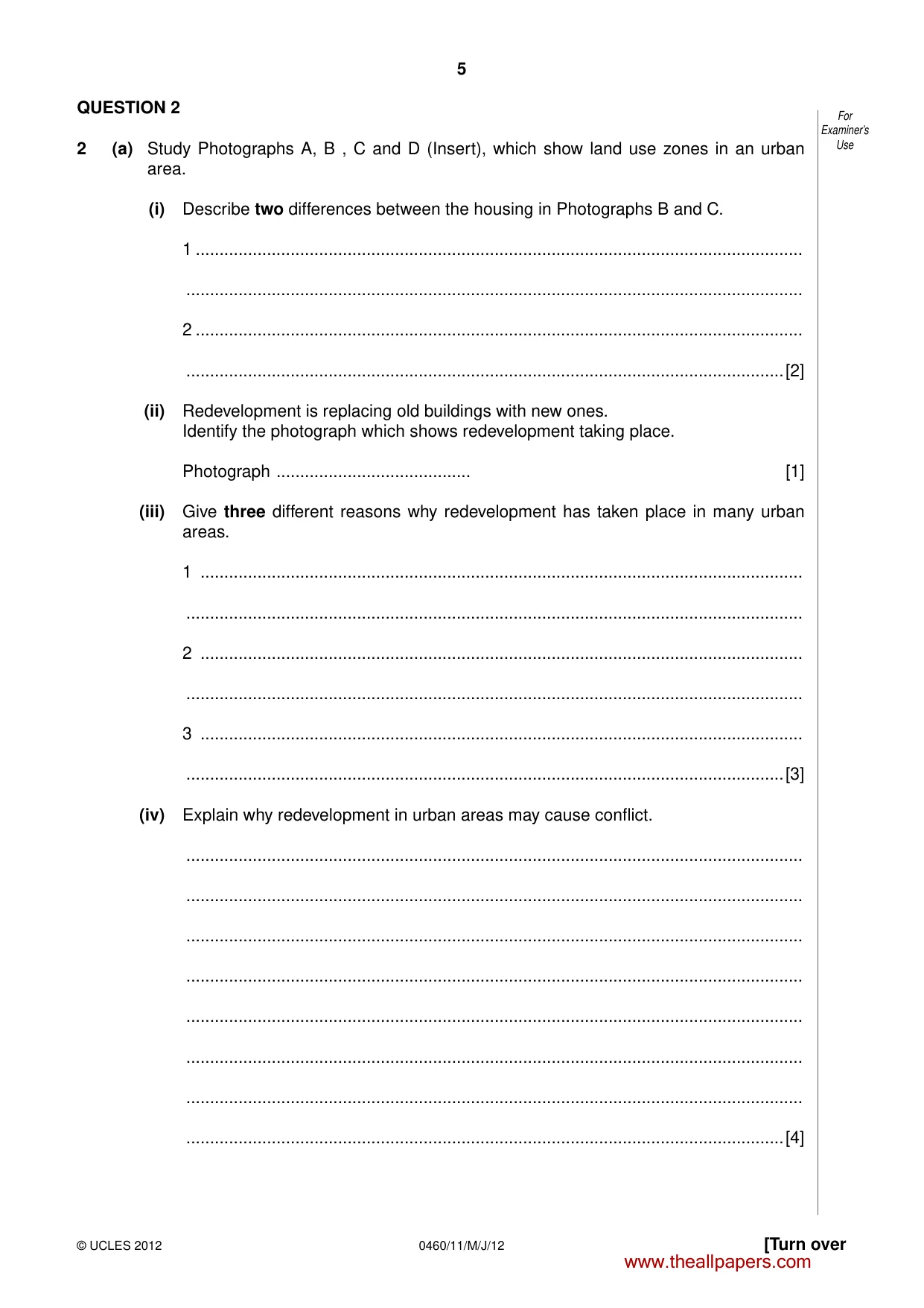
5 © UCLES 2012 [Turn over 0460/11/M/J/12 For Examiner’s Use QUESTION 2 2 (a) Study Photographs A, B , C and D (Insert), which show land use zones in an urban area. (i) Describe two differences between the housing in Photographs B and C. 1 … … 2 … …[2] (ii) Redevelopment is replacing old buildings with new ones. Identify the photograph which shows redevelopment taking place. Photograph … [1] (iii) Give three different reasons why redevelopment has taken place in many urban areas. 1 … … 2 … … 3 … …[3] (iv) Explain why redevelopment in urban areas may cause conflict. … … … … … … … …[4] www.theallpapers.com
Question paper, page 6
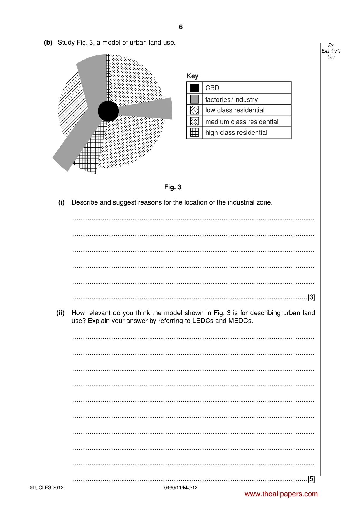
6 © UCLES 2012 0460/11/M/J/12 For Examiner’s Use (b) Study Fig. 3, a model of urban land use. Key CBD factories / industry low class residential medium class residential high class residential Fig. 3 (i) Describe and suggest reasons for the location of the industrial zone. … … … … … …[3] (ii) How relevant do you think the model shown in Fig. 3 is for describing urban land use? Explain your answer by referring to LEDCs and MEDCs. … … … … … … … … … …[5] www.theallpapers.com
Question paper, page 7
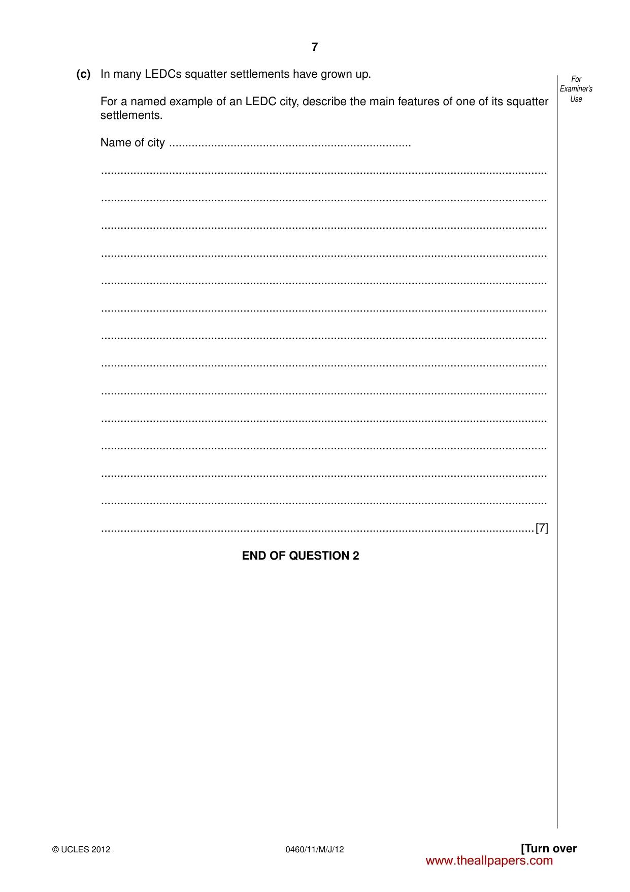
7 © UCLES 2012 [Turn over 0460/11/M/J/12 For Examiner’s Use (c) In many LEDCs squatter settlements have grown up. For a named example of an LEDC city, describe the main features of one of its squatter settlements. Name of city … … … … … … … … … … … … … … …[7] END OF QUESTION 2 www.theallpapers.com
Question paper, page 8
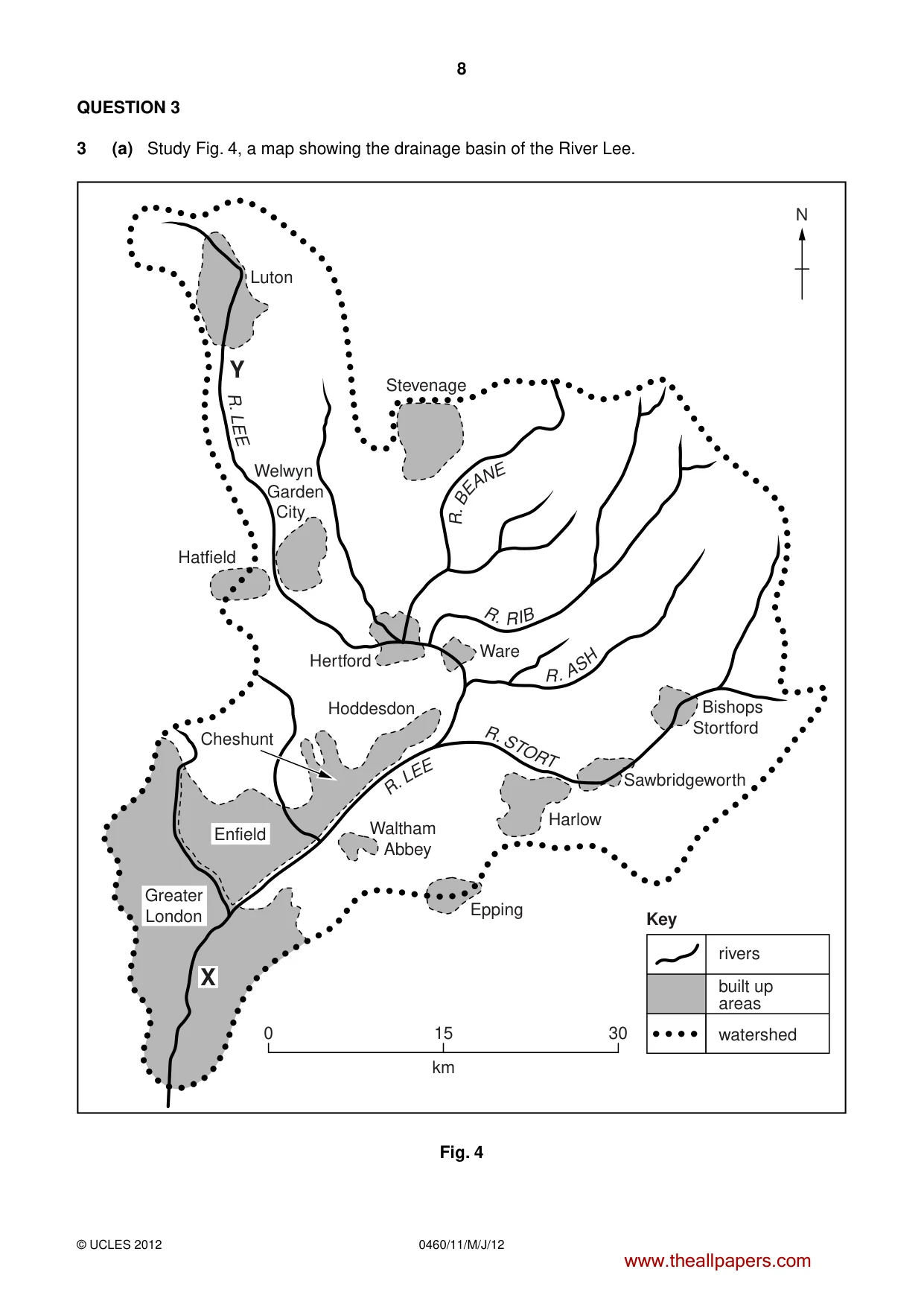
8 0460/11/M/J/12 © UCLES 2012 QUESTION 3 3 (a) Study Fig. 4, a map showing the drainage basin of the River Lee. R . LE E R. L E E R . A S H R. R I B R . B E A NE R . STO R T Greater London Enfield Waltham Abbey Epping rivers built up areas watershed 0 15 km Key 30 Harlow Sawbridgeworth Ware Hertford Hoddesdon Cheshunt Hatfield Stevenage N Y Luton Welwyn Garden City Bishops Stortford X Fig. 4 www.theallpapers.com
Question paper, page 9
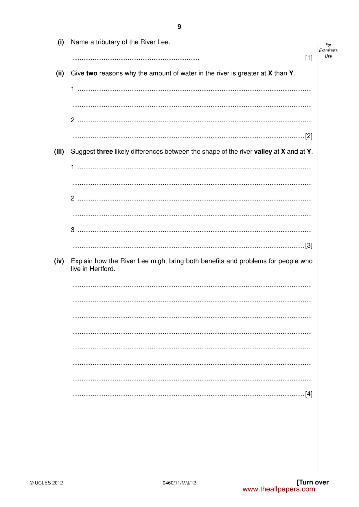
9 © UCLES 2012 [Turn over 0460/11/M/J/12 For Examiner’s Use (i) Name a tributary of the River Lee. … [1] (ii) Give two reasons why the amount of water in the river is greater at X than Y. 1 … … 2 … …[2] (iii) Suggest three likely differences between the shape of the river valley at X and at Y. 1 … … 2 … … 3 … …[3] (iv) Explain how the River Lee might bring both benefits and problems for people who live in Hertford. … … … … … … … …[4] www.theallpapers.com
Question paper, page 10
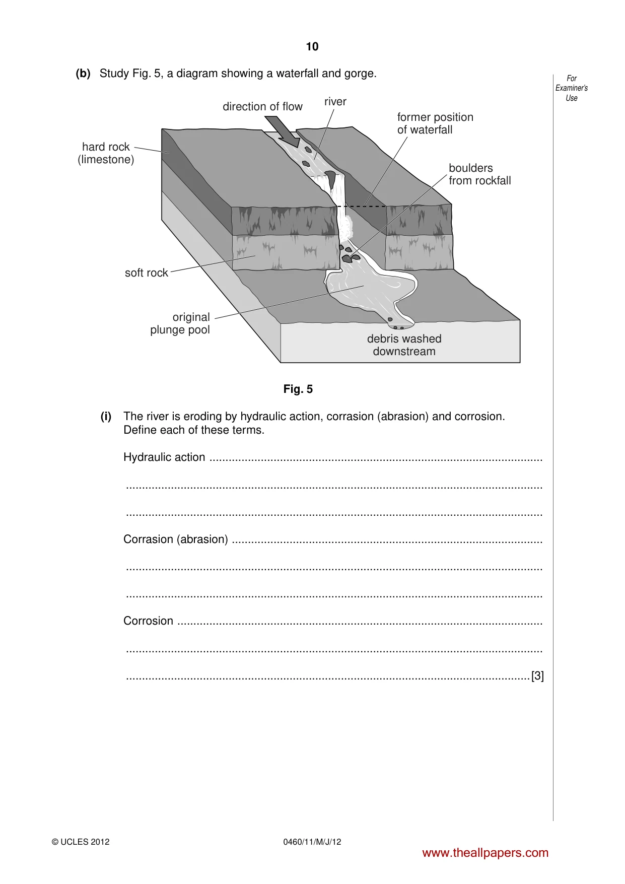
10 © UCLES 2012 0460/11/M/J/12 For Examiner’s Use (b) Study Fig. 5, a diagram showing a waterfall and gorge. debris washed downstream direction of flow original plunge pool hard rock (limestone) soft rock former position of waterfall boulders from rockfall river Fig. 5 (i) The river is eroding by hydraulic action, corrasion (abrasion) and corrosion. Define each of these terms. Hydraulic action … … … Corrasion (abrasion) … … … Corrosion … … …[3] www.theallpapers.com
Question paper, page 11
11 © UCLES 2012 [Turn over 0460/11/M/J/12 For Examiner’s Use (ii) Explain how the waterfall and gorge shown in Fig. 5 have been formed. … … … … … … … … … …[5] www.theallpapers.com
Question paper, page 12
12 © UCLES 2012 0460/11/M/J/12 For Examiner’s Use (c) Explain how an oxbow lake is formed. You should include fully labelled diagram(s). … … … … … … … … … … … … … … [7] END OF QUESTION 3 www.theallpapers.com
Question paper, page 13
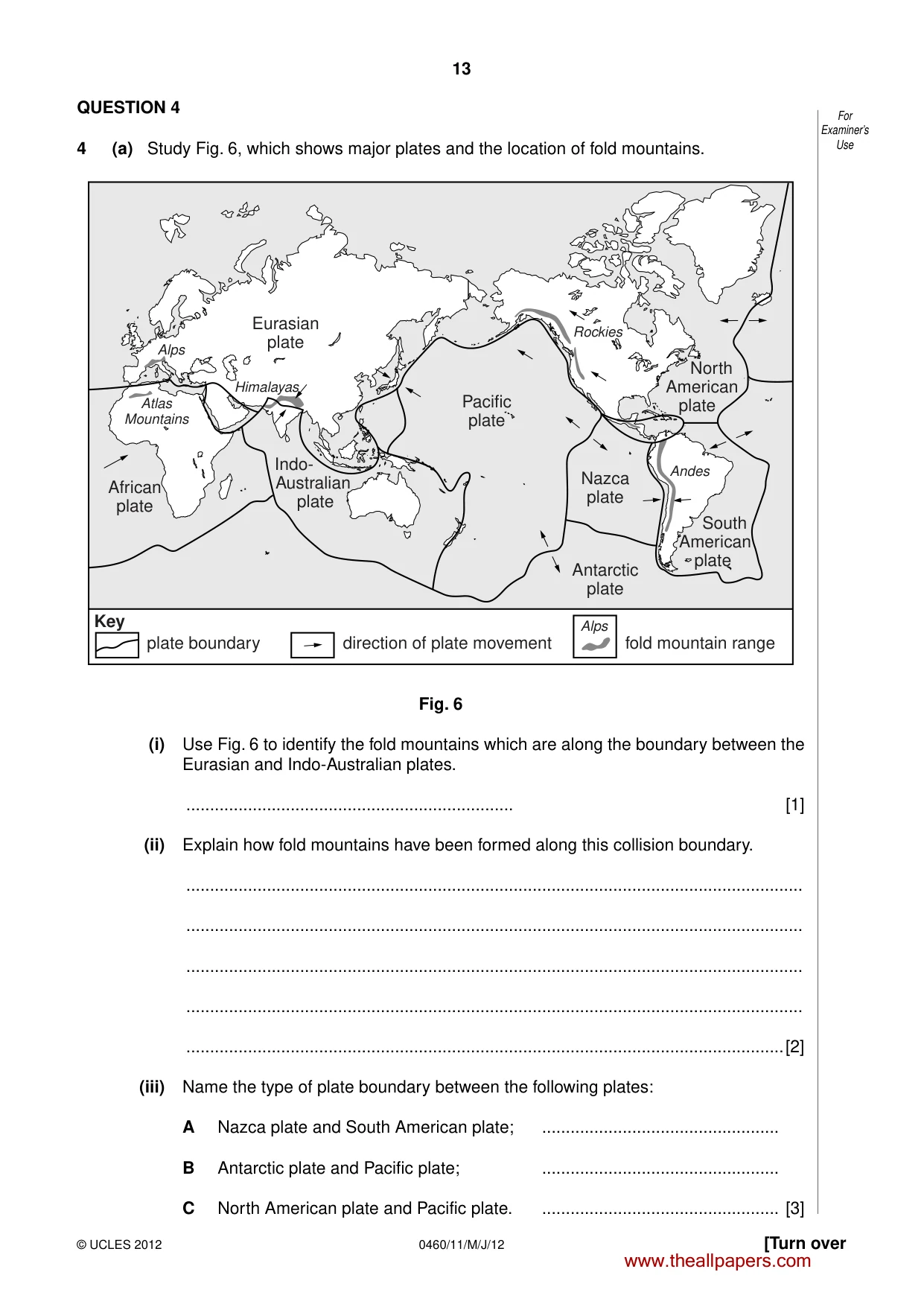
13 © UCLES 2012 [Turn over 0460/11/M/J/12 For Examiner’s Use QUESTION 4 4 (a) Study Fig. 6, which shows major plates and the location of fold mountains. Eurasian plate Pacific plate Antarctic plate Key Nazca plate Rockies Andes Himalayas Alps Alps Atlas Mountains North American plate South American plate African plate plate boundary direction of plate movement Indo- Australian plate fold mountain range Fig. 6 (i) Use Fig. 6 to identify the fold mountains which are along the boundary between the Eurasian and Indo-Australian plates. … [1] (ii) Explain how fold mountains have been formed along this collision boundary. … … … … …[2] (iii) Name the type of plate boundary between the following plates: A Nazca plate and South American plate; … B Antarctic plate and Pacific plate; … C North American plate and Pacific plate. … [3] www.theallpapers.com
Question paper, page 14
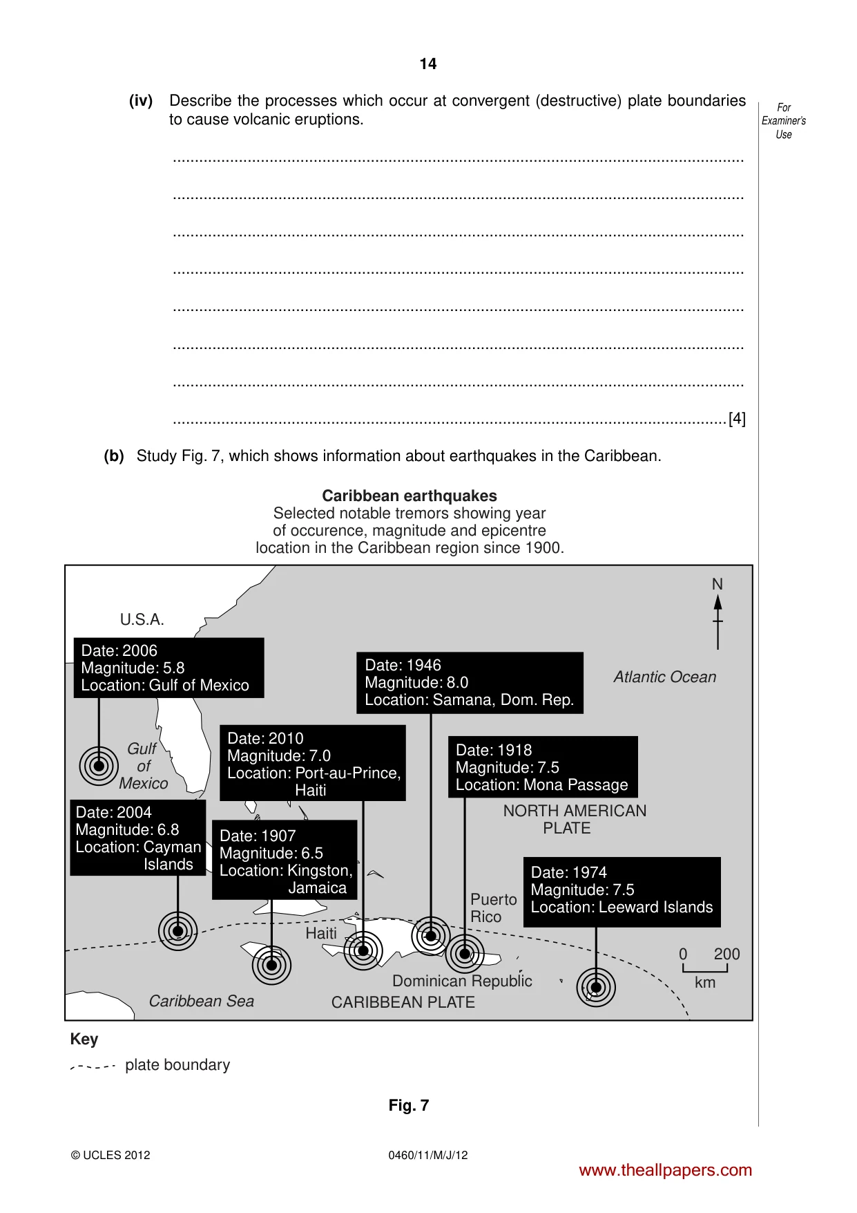
14 © UCLES 2012 0460/11/M/J/12 For Examiner’s Use (iv) Describe the processes which occur at convergent (destructive) plate boundaries to cause volcanic eruptions. … … … … … … … …[4] (b) Study Fig. 7, which shows information about earthquakes in the Caribbean. U.S.A. Key plate boundary Caribbean Sea CARIBBEAN PLATE Haiti Dominican Republic Puerto Rico NORTH AMERICAN PLATE N Caribbean earthquakes Selected notable tremors showing year of occurence, magnitude and epicentre location in the Caribbean region since 1900. 0 200 km Atlantic Ocean Gulf of Mexico Date: 2006 Magnitude: 5.8 Location: Gulf of Mexico Date: 1974 Magnitude: 7.5 Location: Leeward Islands Date: 1918 Magnitude: 7.5 Location: Mona Passage Date: 2010 Magnitude: 7.0 Location: Port-au-Prince, Haiti Date: 2004 Magnitude: 6.8 Location: Cayman Islands Date: 1907 Magnitude: 6.5 Location: Kingston, Jamaica Date: 1946 Magnitude: 8.0 Location: Samana, Dom. Rep. Fig. 7 www.theallpapers.com
Question paper, page 15
15 © UCLES 2012 [Turn over 0460/11/M/J/12 For Examiner’s Use (i) Explain why many earthquakes have occurred in the area shown in Fig. 7. … … … … … …[3] (ii) Many countries in the area shown in Fig. 7 are LEDCs. Explain why earthquakes often have devastating effects in LEDCs. … … … … … … … … … …[5] www.theallpapers.com
Question paper, page 16
16 © UCLES 2012 0460/11/M/J/12 For Examiner’s Use (c) For a named example which you have studied, explain why people live close to a volcano. Name of volcano … … … … … … … … … … … … … … …[7] END OF QUESTION 4 www.theallpapers.com
Question paper, page 17
17 0460/11/M/J/12 © UCLES 2012 [Turn over BLANK PAGE TURN OVER FOR QUESTION 5 www.theallpapers.com
Question paper, page 18
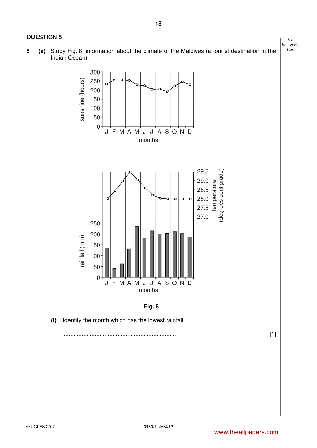
18 © UCLES 2012 0460/11/M/J/12 For Examiner’s Use QUESTION 5 5 (a) Study Fig. 8, information about the climate of the Maldives (a tourist destination in the Indian Ocean). J F M 0 50 100 150 200 rainfall (mm) temperature (degrees centigrade) 250 27.0 27.5 28.0 28.5 29.0 29.5 A M months months J J A S O N D J F M 50 0 100 150 200 sunshine (hours) 250 300 A M J J A S O N D Fig. 8 (i) Identify the month which has the lowest rainfall. … [1] www.theallpapers.com
Question paper, page 19
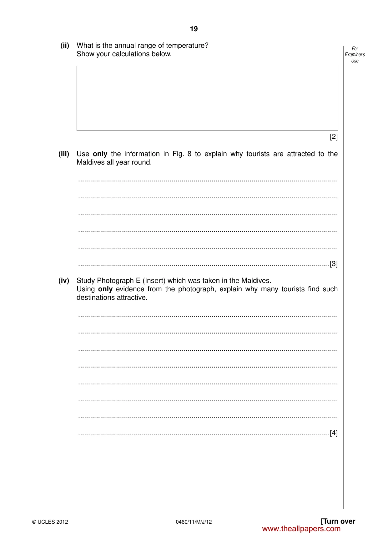
19 © UCLES 2012 [Turn over 0460/11/M/J/12 For Examiner’s Use (ii) What is the annual range of temperature? Show your calculations below. [2] (iii) Use only the information in Fig. 8 to explain why tourists are attracted to the Maldives all year round. … … … … … …[3] (iv) Study Photograph E (Insert) which was taken in the Maldives. Using only evidence from the photograph, explain why many tourists find such destinations attractive. … … … … … … … …[4] www.theallpapers.com
Question paper, page 20
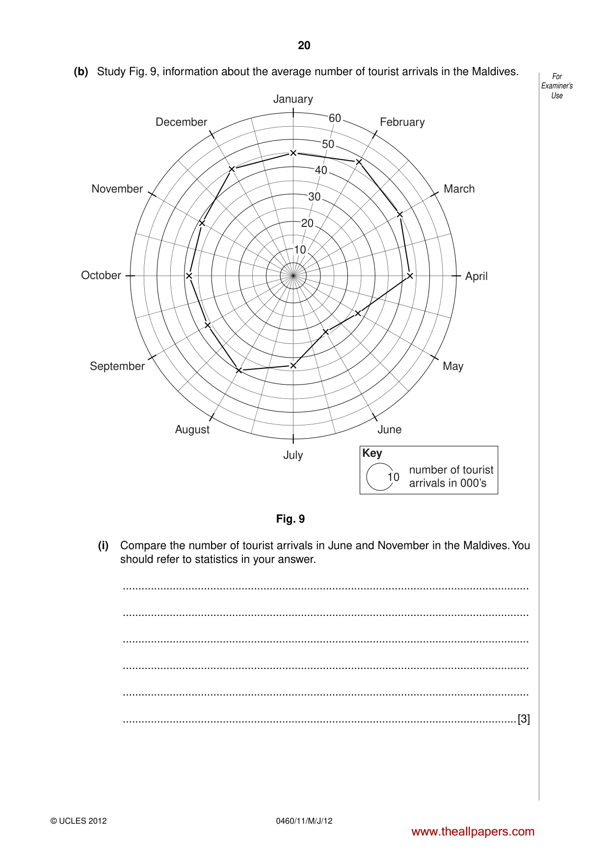
20 © UCLES 2012 0460/11/M/J/12 For Examiner’s Use (b) Study Fig. 9, information about the average number of tourist arrivals in the Maldives. January July April October November March September May December February August June Key number of tourist arrivals in 000’s 10 10 20 30 40 50 60 Fig. 9 (i) Compare the number of tourist arrivals in June and November in the Maldives. You should refer to statistics in your answer. … … … … … …[3] www.theallpapers.com
Question paper, page 21
21 © UCLES 2012 [Turn over 0460/11/M/J/12 For Examiner’s Use (ii) Suggest how the tourist industry benefits and disadvantages the people living in the Maldives. … … … … … … … … … …[5] (c) For a named area which you have studied, explain how tourism is damaging the natural environment. Name of area … … … … … … … … … … … … … … …[7] END OF QUESTION 5 www.theallpapers.com
Question paper, page 22
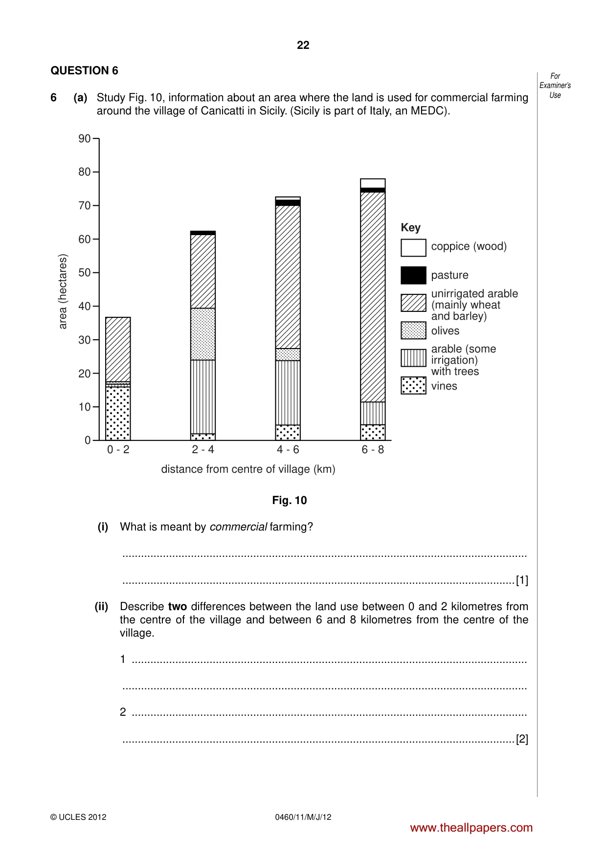
22 © UCLES 2012 0460/11/M/J/12 For Examiner’s Use QUESTION 6 6 (a) Study Fig. 10, information about an area where the land is used for commercial farming around the village of Canicatti in Sicily. (Sicily is part of Italy, an MEDC). 90 80 70 60 50 area (hectares) 0 - 2 2 - 4 4 - 6 distance from centre of village (km) coppice (wood) Key pasture olives vines unirrigated arable (mainly wheat and barley) arable (some irrigation) with trees 6 - 8 40 30 20 10 0 Fig. 10 (i) What is meant by commercial farming? … …[1] (ii) Describe two differences between the land use between 0 and 2 kilometres from the centre of the village and between 6 and 8 kilometres from the centre of the village. 1 … … 2 … …[2] www.theallpapers.com
Question paper, page 23
23 © UCLES 2012 [Turn over 0460/11/M/J/12 For Examiner’s Use (iii) Using examples from Fig. 10, suggest reasons to explain why a farmer may use the land in different ways as distance from the village increases. … … … … … …[3] (iv) Give four examples of physical factors which affect how farmers use their land. 1 … … 2 … … 3 … … 4 … …[4] www.theallpapers.com
Question paper, page 24
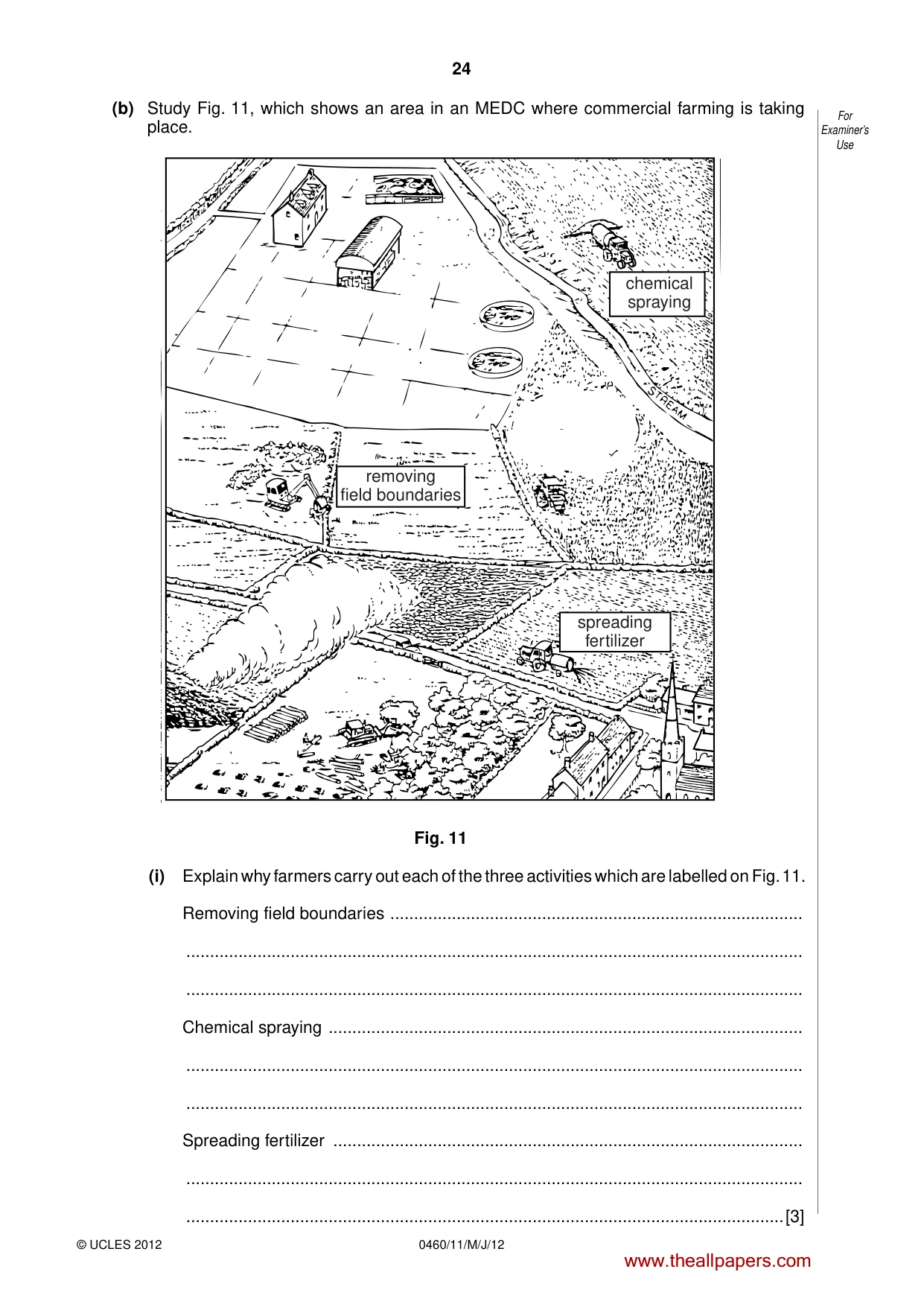
24 © UCLES 2012 0460/11/M/J/12 For Examiner’s Use (b) Study Fig. 11, which shows an area in an MEDC where commercial farming is taking place. chemical spraying removing field boundaries spreading fertilizer Fig. 11 (i) Explain why farmers carry out each of the three activities which are labelled on Fig. 11. Removing field boundaries … … … Chemical spraying … … … Spreading fertilizer … … …[3] www.theallpapers.com
Question paper, page 25
25 © UCLES 2012 [Turn over 0460/11/M/J/12 For Examiner’s Use (ii) Use Fig. 11 and your own knowledge to explain how farming damages the environment. … … … … … … … … … …[5] (c) For an example of small-scale subsistence farming at a named location which you have studied, describe the farming processes. Location of small scale subsistence farming … … … … … … … … … … … … … … …[7] END OF QUESTION 6 www.theallpapers.com
Question paper, page 26
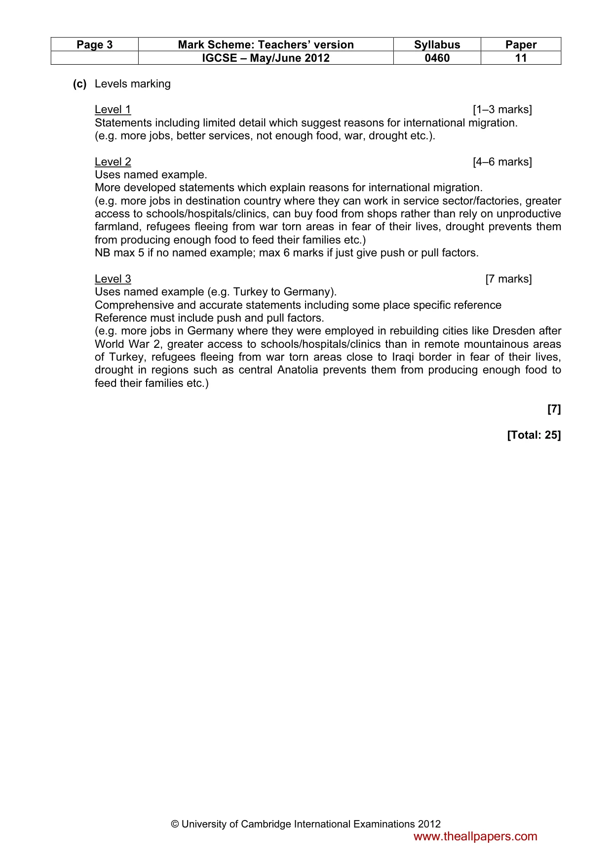
26 © UCLES 2012 0460/11/M/J/12 For Examiner’s Use Additional Page If you use the following lined page to complete the answer(s) to any question(s), the question number(s) must be clearly shown. … … … … … … … … … … … … … … … … … … … … … … … … … … www.theallpapers.com
Question paper, page 27
27 0460/11/M/J/12 © UCLES 2012 BLANK PAGE www.theallpapers.com
Question paper, page 28
28 0460/11/M/J/12 © UCLES 2012 BLANK PAGE Copyright Acknowledgements: Question 2 Photograph A, B, C and D Steve Sibley © UCLES. Question 5 Photograph E Steve Sibley © UCLES. Permission to reproduce items where third-party owned material protected by copyright is included has been sought and cleared where possible. Every reasonable effort has been made by the publisher (UCLES) to trace copyright holders, but if any items requiring clearance have unwittingly been included, the publisher will be pleased to make amends at the earliest possible opportunity. University of Cambridge International Examinations is part of the Cambridge Assessment Group. Cambridge Assessment is the brand name of University of Cambridge Local Examinations Syndicate (UCLES), which is itself a department of the University of Cambridge. www.theallpapers.com
Mark scheme, page 1
UNIVERSITY OF CAMBRIDGE INTERNATIONAL EXAMINATIONS International General Certificate of Secondary Education MARK SCHEME for the May/June 2012 question paper for the guidance of teachers 0460 GEOGRAPHY 0460/11 Paper 1, maximum raw mark 75 This mark scheme is published as an aid to teachers and candidates, to indicate the requirements of the examination. It shows the basis on which Examiners were instructed to award marks. It does not indicate the details of the discussions that took place at an Examiners’ meeting before marking began, which would have considered the acceptability of alternative answers. Mark schemes must be read in conjunction with the question papers and the report on the examination. • Cambridge will not enter into discussions or correspondence in connection with these mark schemes. Cambridge is publishing the mark schemes for the May/June 2012 question papers for most IGCSE, GCE Advanced Level and Advanced Subsidiary Level syllabuses and some Ordinary Level syllabuses. www.theallpapers.com
Mark scheme, page 2
Page 2 Mark Scheme: Teachers’ version Syllabus Paper IGCSE – May/June 2012 0460 11 © University of Cambridge International Examinations 2012 1 (a) (i) Ghana [1] [1] (ii) 19.2 2nd mark for correct calculation shown (ie 28.1 – 8.9) Or BR – DR = Natural population increase. [2 x 1] [2] (iii) A Spain B Ethiopia C Ethiopia [3 x 1] [3] (iv) Ideas such as: Good treatment of diseases/or examples/less spread of disease/less disease/medicine; innoculation against diseases; improved health care facilities/can afford healthcare or examples; training of doctors/nurses; investment in care homes/services for elderly/care for elderly; availability of pensions; no famine/adequate nutrition/food supply/better diet; good sanitation; safe water supplies; healthier lifestyles or examples; education about health; etc. [4 x 1] [4] (b) (i) General decrease; 1.45–1.5% to 1.15% or any other pairs of statistics;(1 mark max or reserve on statistics). Peak in 1962/major increase between 1950–58 or 1960–61 or other relevant dates where increase occurs; dip in 1960/decreases from 1957/ decrease from 1961 onwards; fluctuates; etc. [3 x 1] [3] (ii) One mark reserved for reference to decrease expected [1] Reasoning to MAX 4 such as: [4 x 1] Reduction of birth rates in LEDCs; Smaller families; due to more availability of contraception (dev); due to education re. contraception (dev); less need for children to work in LEDCs; due to more widespread access to education (dev); less likely to need children to look after parents in old age; due to state support/pensions (dev); reduction in IMR/people not needing to have extra children to ensure some survive; education of women/careers/materialistic outlook; traditions/religions are less important in modern society; marry later; increase in death rates/DR higher than BR/reduced life expectancy; due to AIDS/HIV (dev); due to increased drought/famine (dev); war/conflict; government policy/one child policy; [5] www.theallpapers.com
Mark scheme, page 3
Page 3 Mark Scheme: Teachers’ version Syllabus Paper IGCSE – May/June 2012 0460 11 © University of Cambridge International Examinations 2012 (c) Levels marking Level 1 [1–3 marks] Statements including limited detail which suggest reasons for international migration. (e.g. more jobs, better services, not enough food, war, drought etc.). Level 2 [4–6 marks] Uses named example. More developed statements which explain reasons for international migration. (e.g. more jobs in destination country where they can work in service sector/factories, greater access to schools/hospitals/clinics, can buy food from shops rather than rely on unproductive farmland, refugees fleeing from war torn areas in fear of their lives, drought prevents them from producing enough food to feed their families etc.) NB max 5 if no named example; max 6 marks if just give push or pull factors. Level 3 [7 marks] Uses named example (e.g. Turkey to Germany). Comprehensive and accurate statements including some place specific reference Reference must include push and pull factors. (e.g. more jobs in Germany where they were employed in rebuilding cities like Dresden after World War 2, greater access to schools/hospitals/clinics than in remote mountainous areas of Turkey, refugees fleeing from war torn areas close to Iraqi border in fear of their lives, drought in regions such as central Anatolia prevents them from producing enough food to feed their families etc.) [7] [Total: 25] www.theallpapers.com
Mark scheme, page 4
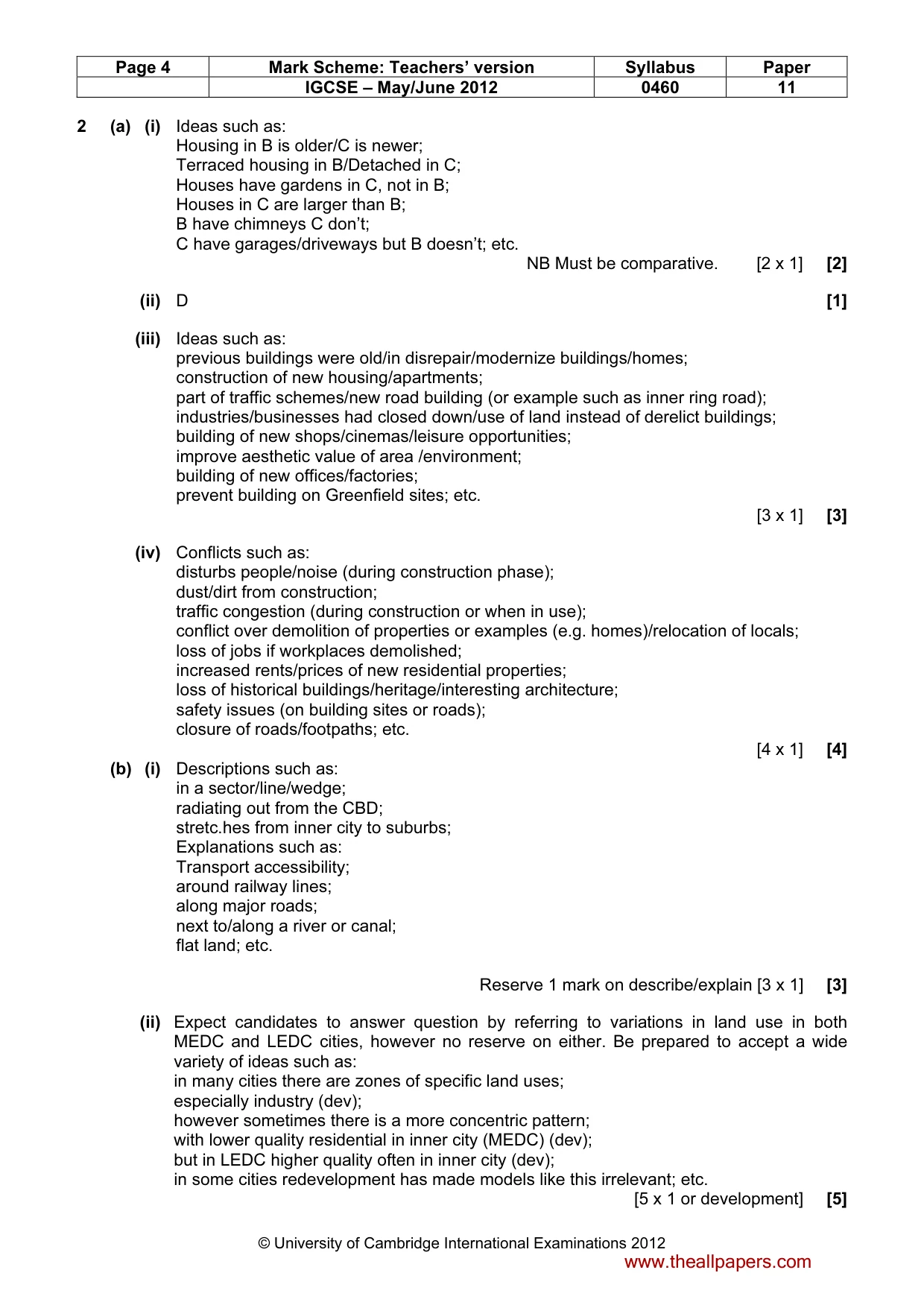
Page 4 Mark Scheme: Teachers’ version Syllabus Paper IGCSE – May/June 2012 0460 11 © University of Cambridge International Examinations 2012 2 (a) (i) Ideas such as: Housing in B is older/C is newer; Terraced housing in B/Detached in C; Houses have gardens in C, not in B; Houses in C are larger than B; B have chimneys C don’t; C have garages/driveways but B doesn’t; etc. NB Must be comparative. [2 x 1] [2] (ii) D [1] (iii) Ideas such as: previous buildings were old/in disrepair/modernize buildings/homes; construction of new housing/apartments; part of traffic schemes/new road building (or example such as inner ring road); industries/businesses had closed down/use of land instead of derelict buildings; building of new shops/cinemas/leisure opportunities; improve aesthetic value of area /environment; building of new offices/factories; prevent building on Greenfield sites; etc. [3 x 1] [3] (iv) Conflicts such as: disturbs people/noise (during construction phase); dust/dirt from construction; traffic congestion (during construction or when in use); conflict over demolition of properties or examples (e.g. homes)/relocation of locals; loss of jobs if workplaces demolished; increased rents/prices of new residential properties; loss of historical buildings/heritage/interesting architecture; safety issues (on building sites or roads); closure of roads/footpaths; etc. [4 x 1] [4] (b) (i) Descriptions such as: in a sector/line/wedge; radiating out from the CBD; stretc.hes from inner city to suburbs; Explanations such as: Transport accessibility; around railway lines; along major roads; next to/along a river or canal; flat land; etc. Reserve 1 mark on describe/explain [3 x 1] [3] (ii) Expect candidates to answer question by referring to variations in land use in both MEDC and LEDC cities, however no reserve on either. Be prepared to accept a wide variety of ideas such as: in many cities there are zones of specific land uses; especially industry (dev); however sometimes there is a more concentric pattern; with lower quality residential in inner city (MEDC) (dev); but in LEDC higher quality often in inner city (dev); in some cities redevelopment has made models like this irrelevant; etc. [5 x 1 or development] [5] www.theallpapers.com
Mark scheme, page 5
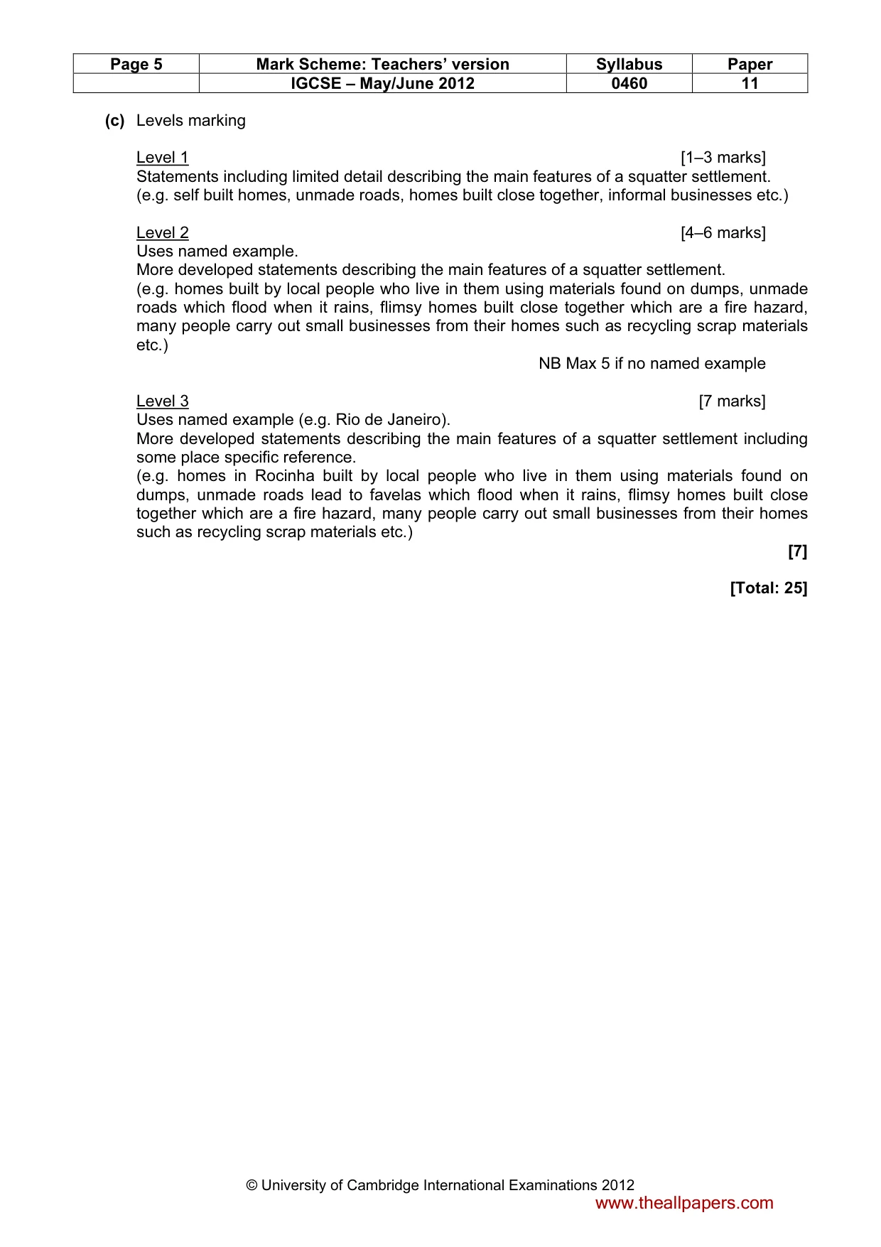
Page 5 Mark Scheme: Teachers’ version Syllabus Paper IGCSE – May/June 2012 0460 11 © University of Cambridge International Examinations 2012 (c) Levels marking Level 1 [1–3 marks] Statements including limited detail describing the main features of a squatter settlement. (e.g. self built homes, unmade roads, homes built close together, informal businesses etc.) Level 2 [4–6 marks] Uses named example. More developed statements describing the main features of a squatter settlement. (e.g. homes built by local people who live in them using materials found on dumps, unmade roads which flood when it rains, flimsy homes built close together which are a fire hazard, many people carry out small businesses from their homes such as recycling scrap materials etc.) NB Max 5 if no named example Level 3 [7 marks] Uses named example (e.g. Rio de Janeiro). More developed statements describing the main features of a squatter settlement including some place specific reference. (e.g. homes in Rocinha built by local people who live in them using materials found on dumps, unmade roads lead to favelas which flood when it rains, flimsy homes built close together which are a fire hazard, many people carry out small businesses from their homes such as recycling scrap materials etc.) [7] [Total: 25] www.theallpapers.com
Mark scheme, page 6
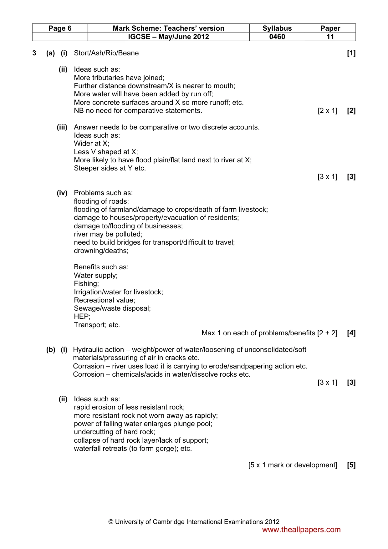
Page 6 Mark Scheme: Teachers’ version Syllabus Paper IGCSE – May/June 2012 0460 11 © University of Cambridge International Examinations 2012 3 (a) (i) Stort/Ash/Rib/Beane [1] (ii) Ideas such as: More tributaries have joined; Further distance downstream/X is nearer to mouth; More water will have been added by run off; More concrete surfaces around X so more runoff; etc. NB no need for comparative statements. [2 x 1] [2] (iii) Answer needs to be comparative or two discrete accounts. Ideas such as: Wider at X; Less V shaped at X; More likely to have flood plain/flat land next to river at X; Steeper sides at Y etc. [3 x 1] [3] (iv) Problems such as: flooding of roads; flooding of farmland/damage to crops/death of farm livestock; damage to houses/property/evacuation of residents; damage to/flooding of businesses; river may be polluted; need to build bridges for transport/difficult to travel; drowning/deaths; Benefits such as: Water supply; Fishing; Irrigation/water for livestock; Recreational value; Sewage/waste disposal; HEP; Transport; etc. Max 1 on each of problems/benefits [2 + 2] [4] (b) (i) Hydraulic action – weight/power of water/loosening of unconsolidated/soft materials/pressuring of air in cracks etc. Corrasion – river uses load it is carrying to erode/sandpapering action etc. Corrosion – chemicals/acids in water/dissolve rocks etc. [3 x 1] [3] (ii) Ideas such as: rapid erosion of less resistant rock; more resistant rock not worn away as rapidly; power of falling water enlarges plunge pool; undercutting of hard rock; collapse of hard rock layer/lack of support; waterfall retreats (to form gorge); etc. [5 x 1 mark or development] [5] www.theallpapers.com
Mark scheme, page 7
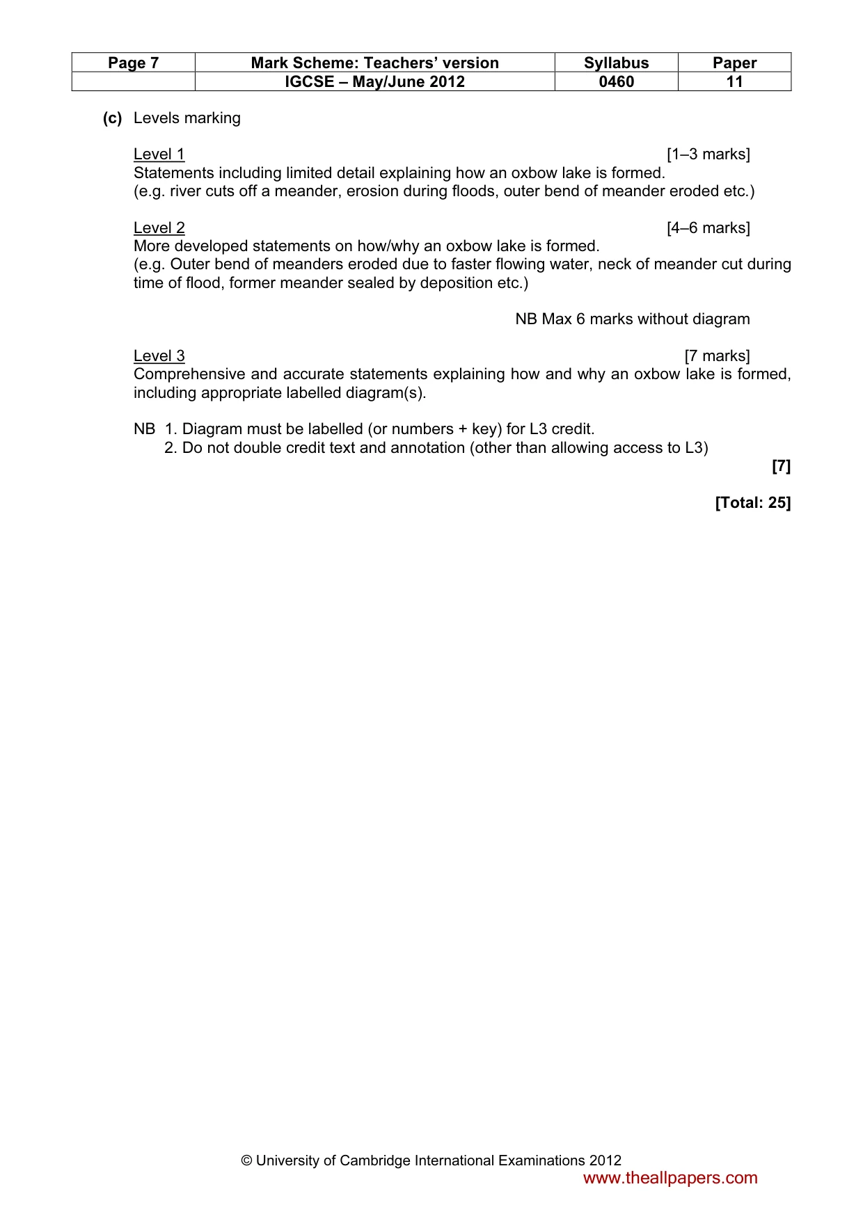
Page 7 Mark Scheme: Teachers’ version Syllabus Paper IGCSE – May/June 2012 0460 11 © University of Cambridge International Examinations 2012 (c) Levels marking Level 1 [1–3 marks] Statements including limited detail explaining how an oxbow lake is formed. (e.g. river cuts off a meander, erosion during floods, outer bend of meander eroded etc.) Level 2 [4–6 marks] More developed statements on how/why an oxbow lake is formed. (e.g. Outer bend of meanders eroded due to faster flowing water, neck of meander cut during time of flood, former meander sealed by deposition etc.) NB Max 6 marks without diagram Level 3 [7 marks] Comprehensive and accurate statements explaining how and why an oxbow lake is formed, including appropriate labelled diagram(s). NB 1. Diagram must be labelled (or numbers + key) for L3 credit. 2. Do not double credit text and annotation (other than allowing access to L3) [7] [Total: 25] www.theallpapers.com
Mark scheme, page 8
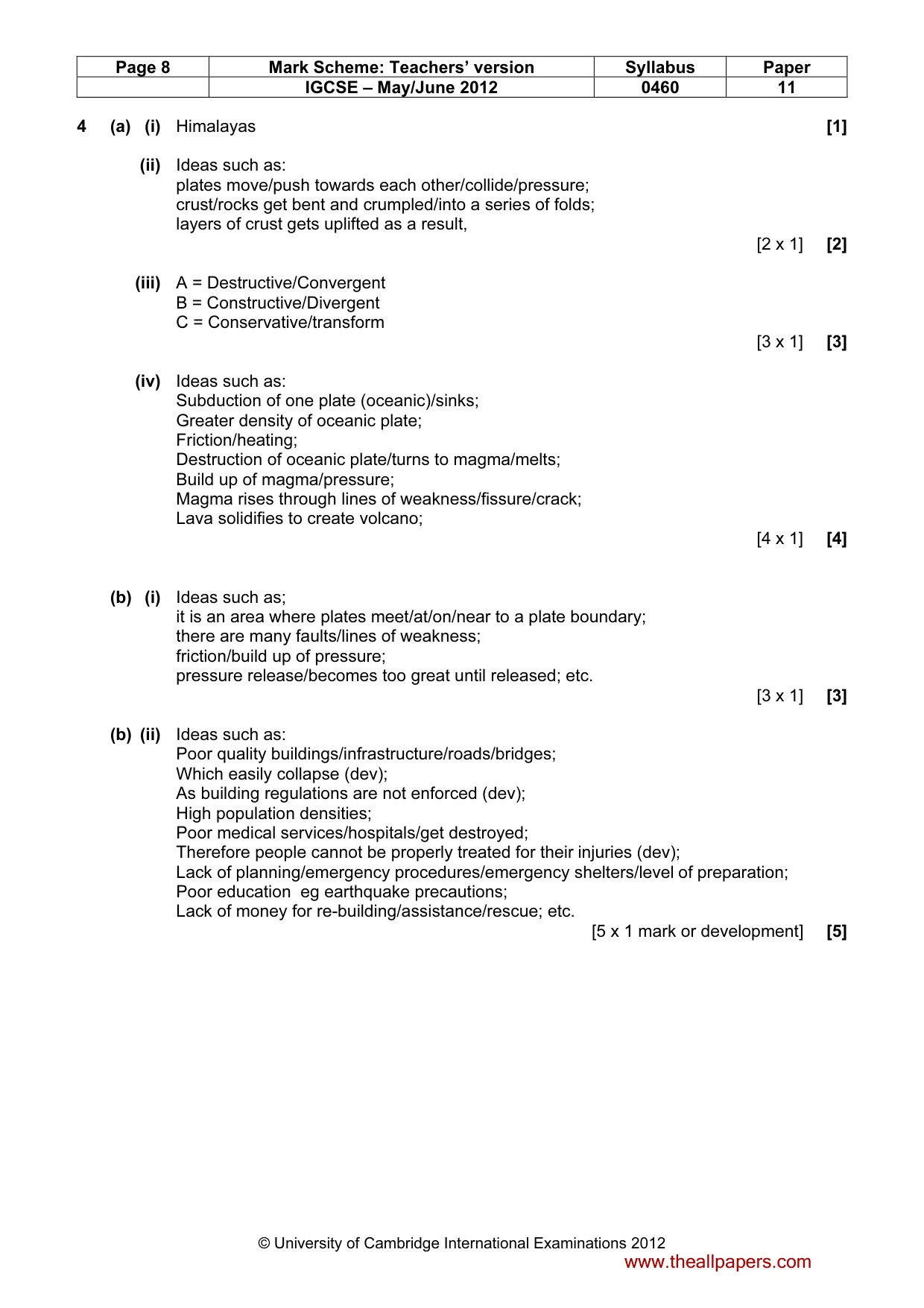
Page 8 Mark Scheme: Teachers’ version Syllabus Paper IGCSE – May/June 2012 0460 11 © University of Cambridge International Examinations 2012 4 (a) (i) Himalayas [1] (ii) Ideas such as: plates move/push towards each other/collide/pressure; crust/rocks get bent and crumpled/into a series of folds; layers of crust gets uplifted as a result, [2 x 1] [2] (iii) A = Destructive/Convergent B = Constructive/Divergent C = Conservative/transform [3 x 1] [3] (iv) Ideas such as: Subduction of one plate (oceanic)/sinks; Greater density of oceanic plate; Friction/heating; Destruction of oceanic plate/turns to magma/melts; Build up of magma/pressure; Magma rises through lines of weakness/fissure/crack; Lava solidifies to create volcano; [4 x 1] [4] (b) (i) Ideas such as; it is an area where plates meet/at/on/near to a plate boundary; there are many faults/lines of weakness; friction/build up of pressure; pressure release/becomes too great until released; etc. [3 x 1] [3] (b) (ii) Ideas such as: Poor quality buildings/infrastructure/roads/bridges; Which easily collapse (dev); As building regulations are not enforced (dev); High population densities; Poor medical services/hospitals/get destroyed; Therefore people cannot be properly treated for their injuries (dev); Lack of planning/emergency procedures/emergency shelters/level of preparation; Poor education eg earthquake precautions; Lack of money for re-building/assistance/rescue; etc. [5 x 1 mark or development] [5] www.theallpapers.com
Mark scheme, page 9
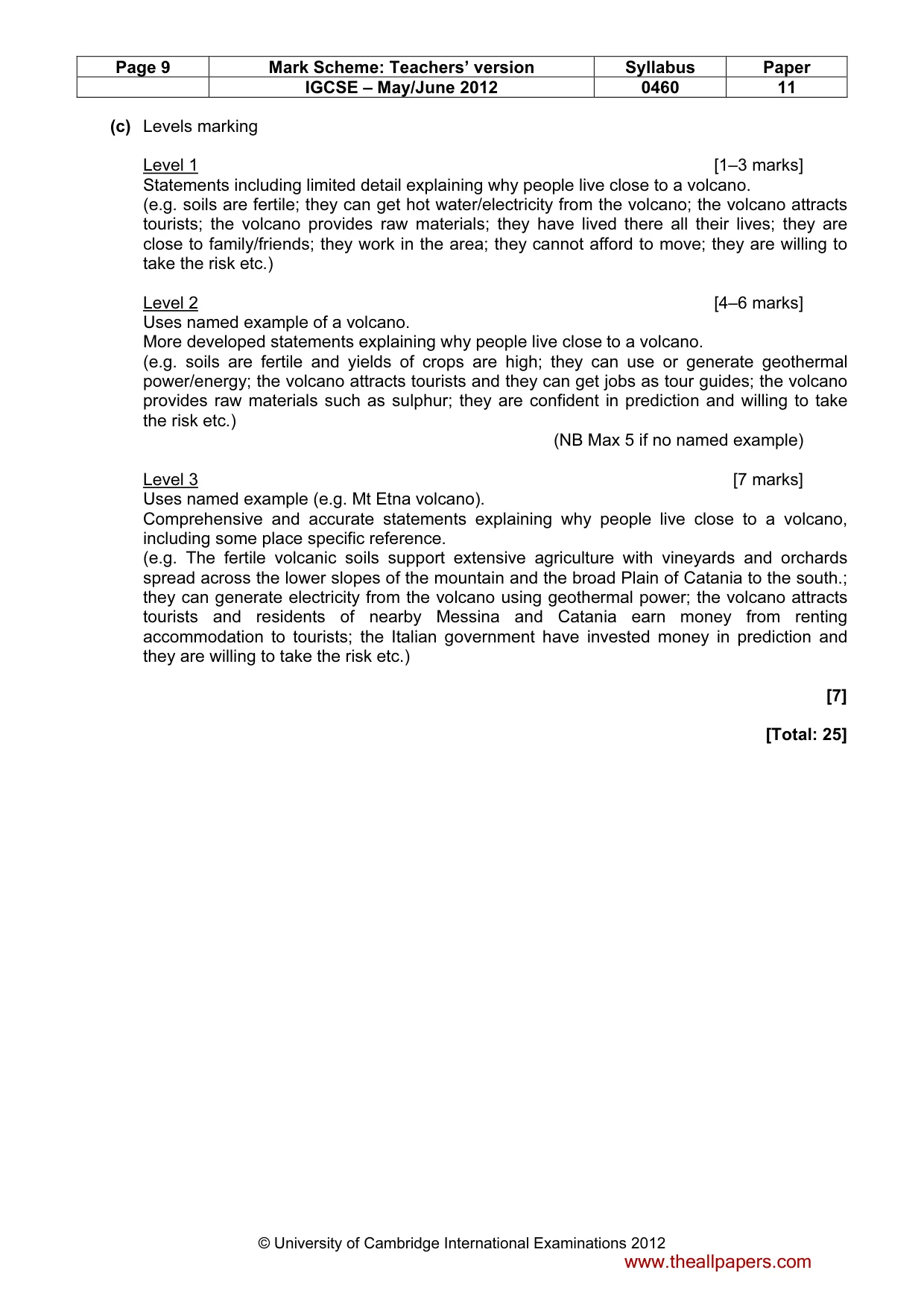
Page 9 Mark Scheme: Teachers’ version Syllabus Paper IGCSE – May/June 2012 0460 11 © University of Cambridge International Examinations 2012 (c) Levels marking Level 1 [1–3 marks] Statements including limited detail explaining why people live close to a volcano. (e.g. soils are fertile; they can get hot water/electricity from the volcano; the volcano attracts tourists; the volcano provides raw materials; they have lived there all their lives; they are close to family/friends; they work in the area; they cannot afford to move; they are willing to take the risk etc.) Level 2 [4–6 marks] Uses named example of a volcano. More developed statements explaining why people live close to a volcano. (e.g. soils are fertile and yields of crops are high; they can use or generate geothermal power/energy; the volcano attracts tourists and they can get jobs as tour guides; the volcano provides raw materials such as sulphur; they are confident in prediction and willing to take the risk etc.) (NB Max 5 if no named example) Level 3 [7 marks] Uses named example (e.g. Mt Etna volcano). Comprehensive and accurate statements explaining why people live close to a volcano, including some place specific reference. (e.g. The fertile volcanic soils support extensive agriculture with vineyards and orchards spread across the lower slopes of the mountain and the broad Plain of Catania to the south.; they can generate electricity from the volcano using geothermal power; the volcano attracts tourists and residents of nearby Messina and Catania earn money from renting accommodation to tourists; the Italian government have invested money in prediction and they are willing to take the risk etc.) [7] [Total: 25] www.theallpapers.com
Mark scheme, page 10
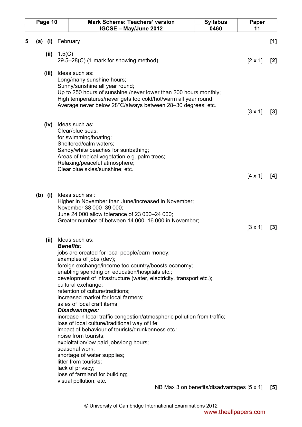
Page 10 Mark Scheme: Teachers’ version Syllabus Paper IGCSE – May/June 2012 0460 11 © University of Cambridge International Examinations 2012 5 (a) (i) February [1] (ii) 1.5(C) 29.5–28(C) (1 mark for showing method) [2 x 1] [2] (iii) Ideas such as: Long/many sunshine hours; Sunny/sunshine all year round; Up to 250 hours of sunshine /never lower than 200 hours monthly; High temperatures/never gets too cold/hot/warm all year round; Average never below 28°C/always between 28–30 degrees; etc. [3 x 1] [3] (iv) Ideas such as: Clear/blue seas; for swimming/boating; Sheltered/calm waters; Sandy/white beaches for sunbathing; Areas of tropical vegetation e.g. palm trees; Relaxing/peaceful atmosphere; Clear blue skies/sunshine; etc. [4 x 1] [4] (b) (i) Ideas such as : Higher in November than June/increased in November; November 38 000–39 000; June 24 000 allow tolerance of 23 000–24 000; Greater number of between 14 000–16 000 in November; [3 x 1] [3] (ii) Ideas such as: Benefits: jobs are created for local people/earn money; examples of jobs (dev); foreign exchange/income too country/boosts economy; enabling spending on education/hospitals etc.; development of infrastructure (water, electricity, transport etc.); cultural exchange; retention of culture/traditions; increased market for local farmers; sales of local craft items. Disadvantages: increase in local traffic congestion/atmospheric pollution from traffic; loss of local culture/traditional way of life; impact of behaviour of tourists/drunkenness etc.; noise from tourists; exploitation/low paid jobs/long hours; seasonal work; shortage of water supplies; litter from tourists; lack of privacy; loss of farmland for building; visual pollution; etc. NB Max 3 on benefits/disadvantages [5 x 1] [5] www.theallpapers.com
Mark scheme, page 11
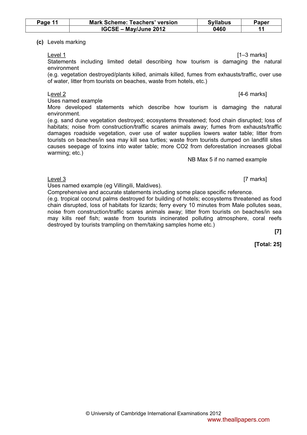
Page 11 Mark Scheme: Teachers’ version Syllabus Paper IGCSE – May/June 2012 0460 11 © University of Cambridge International Examinations 2012 (c) Levels marking Level 1 [1–3 marks] Statements including limited detail describing how tourism is damaging the natural environment (e.g. vegetation destroyed/plants killed, animals killed, fumes from exhausts/traffic, over use of water, litter from tourists on beaches, waste from hotels, etc.) Level 2 [4-6 marks] Uses named example More developed statements which describe how tourism is damaging the natural environment. (e.g. sand dune vegetation destroyed; ecosystems threatened; food chain disrupted; loss of habitats; noise from construction/traffic scares animals away; fumes from exhausts/traffic damages roadside vegetation, over use of water supplies lowers water table; litter from tourists on beaches/in sea may kill sea turtles; waste from tourists dumped on landfill sites causes seepage of toxins into water table; more CO2 from deforestation increases global warming; etc.) NB Max 5 if no named example Level 3 [7 marks] Uses named example (eg Villingili, Maldives). Comprehensive and accurate statements including some place specific reference. (e.g. tropical coconut palms destroyed for building of hotels; ecosystems threatened as food chain disrupted, loss of habitats for lizards; ferry every 10 minutes from Male pollutes seas, noise from construction/traffic scares animals away; litter from tourists on beaches/in sea may kills reef fish; waste from tourists incinerated polluting atmosphere, coral reefs destroyed by tourists trampling on them/taking samples home etc.) [7] [Total: 25] www.theallpapers.com
Mark scheme, page 12
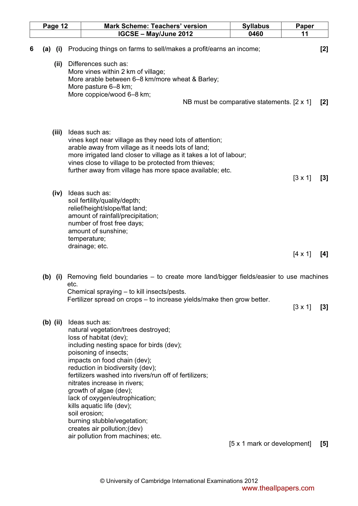
Page 12 Mark Scheme: Teachers’ version Syllabus Paper IGCSE – May/June 2012 0460 11 © University of Cambridge International Examinations 2012 6 (a) (i) Producing things on farms to sell/makes a profit/earns an income; [2] (ii) Differences such as: More vines within 2 km of village; More arable between 6–8 km/more wheat & Barley; More pasture 6–8 km; More coppice/wood 6–8 km; NB must be comparative statements. [2 x 1] [2] (iii) Ideas such as: vines kept near village as they need lots of attention; arable away from village as it needs lots of land; more irrigated land closer to village as it takes a lot of labour; vines close to village to be protected from thieves; further away from village has more space available; etc. [3 x 1] [3] (iv) Ideas such as: soil fertility/quality/depth; relief/height/slope/flat land; amount of rainfall/precipitation; number of frost free days; amount of sunshine; temperature; drainage; etc. [4 x 1] [4] (b) (i) Removing field boundaries – to create more land/bigger fields/easier to use machines etc. Chemical spraying – to kill insects/pests. Fertilizer spread on crops – to increase yields/make then grow better. [3 x 1] [3] (b) (ii) Ideas such as: natural vegetation/trees destroyed; loss of habitat (dev); including nesting space for birds (dev); poisoning of insects; impacts on food chain (dev); reduction in biodiversity (dev); fertilizers washed into rivers/run off of fertilizers; nitrates increase in rivers; growth of algae (dev); lack of oxygen/eutrophication; kills aquatic life (dev); soil erosion; burning stubble/vegetation; creates air pollution;(dev) air pollution from machines; etc. [5 x 1 mark or development] [5] www.theallpapers.com
Mark scheme, page 13
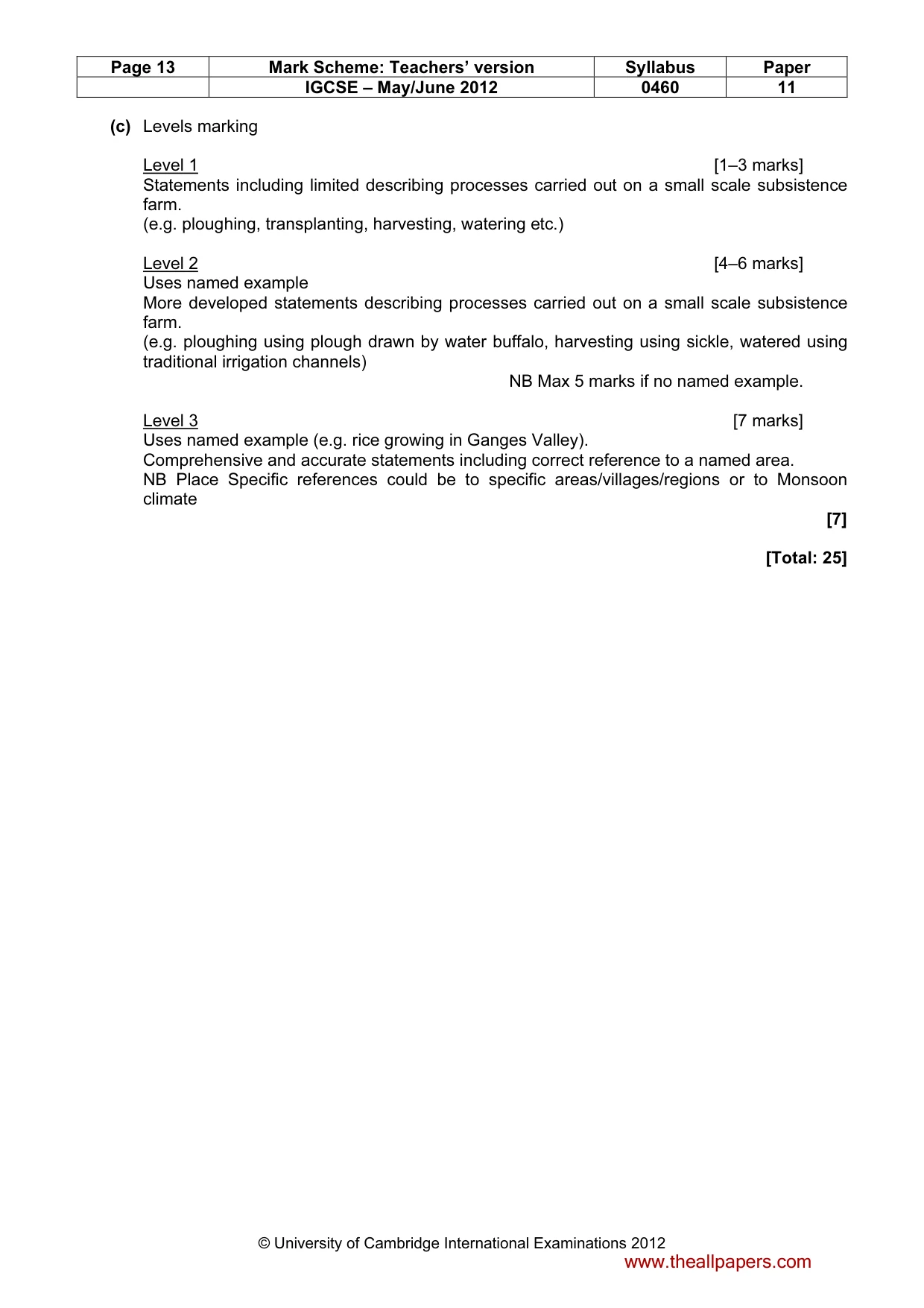
Page 13 Mark Scheme: Teachers’ version Syllabus Paper IGCSE – May/June 2012 0460 11 © University of Cambridge International Examinations 2012 (c) Levels marking Level 1 [1–3 marks] Statements including limited describing processes carried out on a small scale subsistence farm. (e.g. ploughing, transplanting, harvesting, watering etc.) Level 2 [4–6 marks] Uses named example More developed statements describing processes carried out on a small scale subsistence farm. (e.g. ploughing using plough drawn by water buffalo, harvesting using sickle, watered using traditional irrigation channels) NB Max 5 marks if no named example. Level 3 [7 marks] Uses named example (e.g. rice growing in Ganges Valley). Comprehensive and accurate statements including correct reference to a named area. NB Place Specific references could be to specific areas/villages/regions or to Monsoon climate [7] [Total: 25] www.theallpapers.com
What you needed in this session
Cambridge’s own grade thresholds for 2012 May/June, Paper 1 · Variant 1. A higher threshold means an easier paper — the bar moves with how the cohort did.