Cambridge IGCSE Geography 0460 — 2012 May/June Paper 1 · Variant 3
0460/13/M/J/12 · 75 marks · ≈84 min
The question paper and its mark scheme, free to read here and free to download. This is Cambridge’s own paper, exactly as it was sat.
Question paper24 pages





Mark scheme13 pages
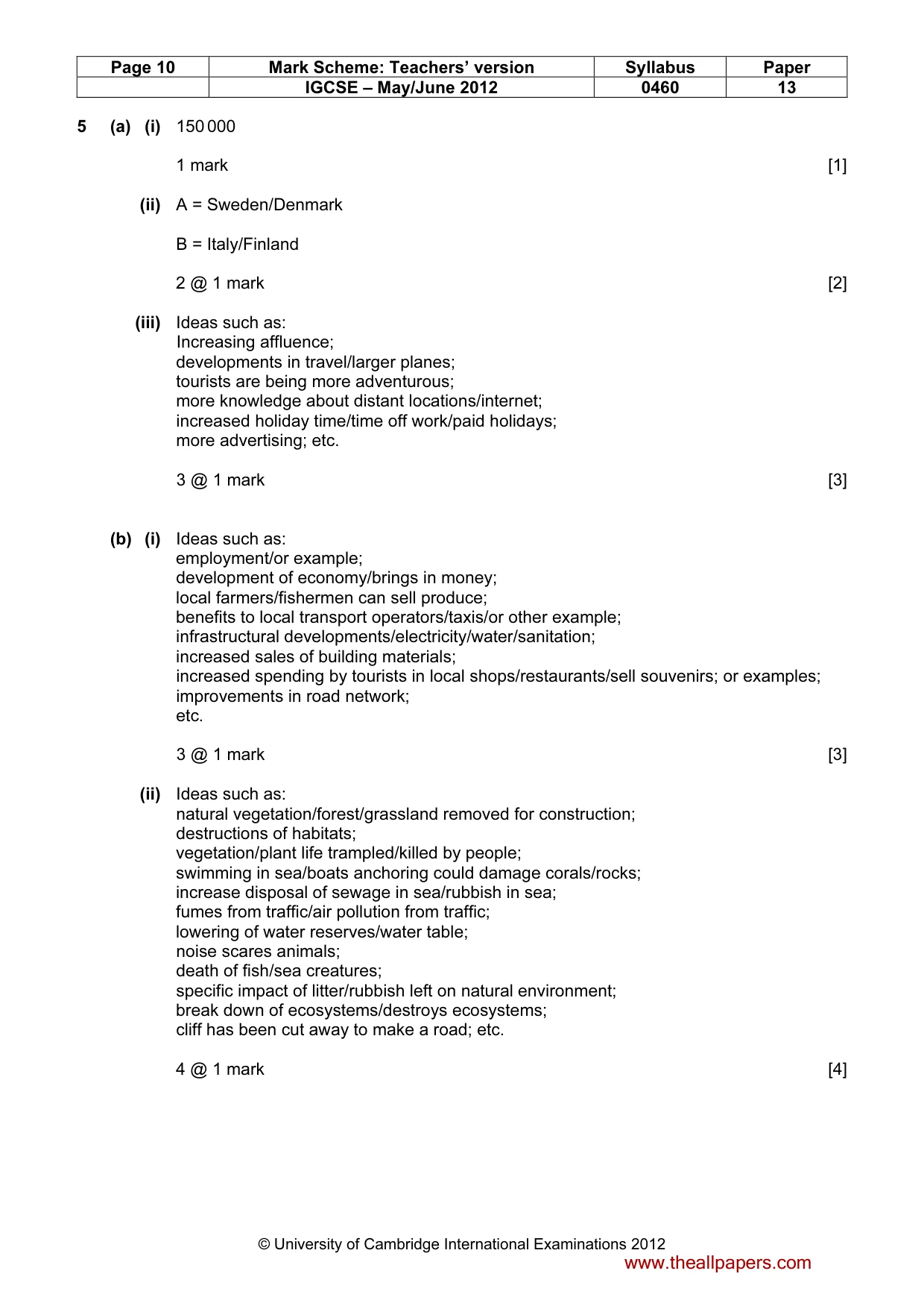
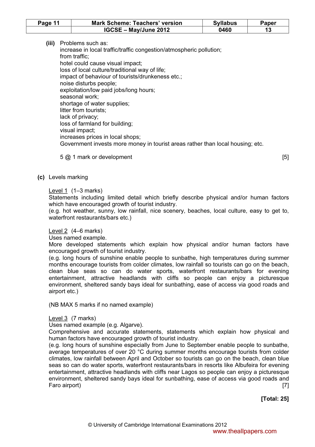
Answers below. Sit the paper first if you are practising.
Paper as text
Question paper, page 1
This document consists of 21 printed pages, 3 blank pages and 1 Insert. DC (AC/JG) 47758/6 © UCLES 2012 [Turn over * 6 2 7 8 2 3 8 3 6 6 * GEOGRAPHY 0460/13 Paper 1 May/June 2012 1 hour 45 minutes Candidates answer on the Question Paper. Additional Materials: Ruler READ THESE INSTRUCTIONS FIRST Write your Centre number, candidate number and name in the spaces provided. Write in dark blue or black pen. You may use a soft pencil for any diagrams, graphs or rough working. Do not use staples, paper clips, highlighters, glue or correction fluid. DO NOT WRITE ON ANY BARCODES. Write your answer to each question in the space provided. If additional space is required, you should use the lined page at the end of this booklet. The question number(s) must be clearly shown. Answer three questions. The Insert contains Photographs A and B for Question 2, Photographs C and D for Question 3, Fig. 5 for Question 4 and Photograph E for Question 5. The Insert is not required by the Examiner. Sketch maps and diagrams should be drawn whenever they serve to illustrate an answer. At the end of the examination, fasten all your work securely together. The number of marks is given in brackets[ ] at the end of each question or part question. UNIVERSITY OF CAMBRIDGE INTERNATIONAL EXAMINATIONS International General Certificate of Secondary Education For Examiner’s Use Q1 Q2 Q3 Q4 Q5 Q6 Total www.theallpapers.com
Question paper, page 2
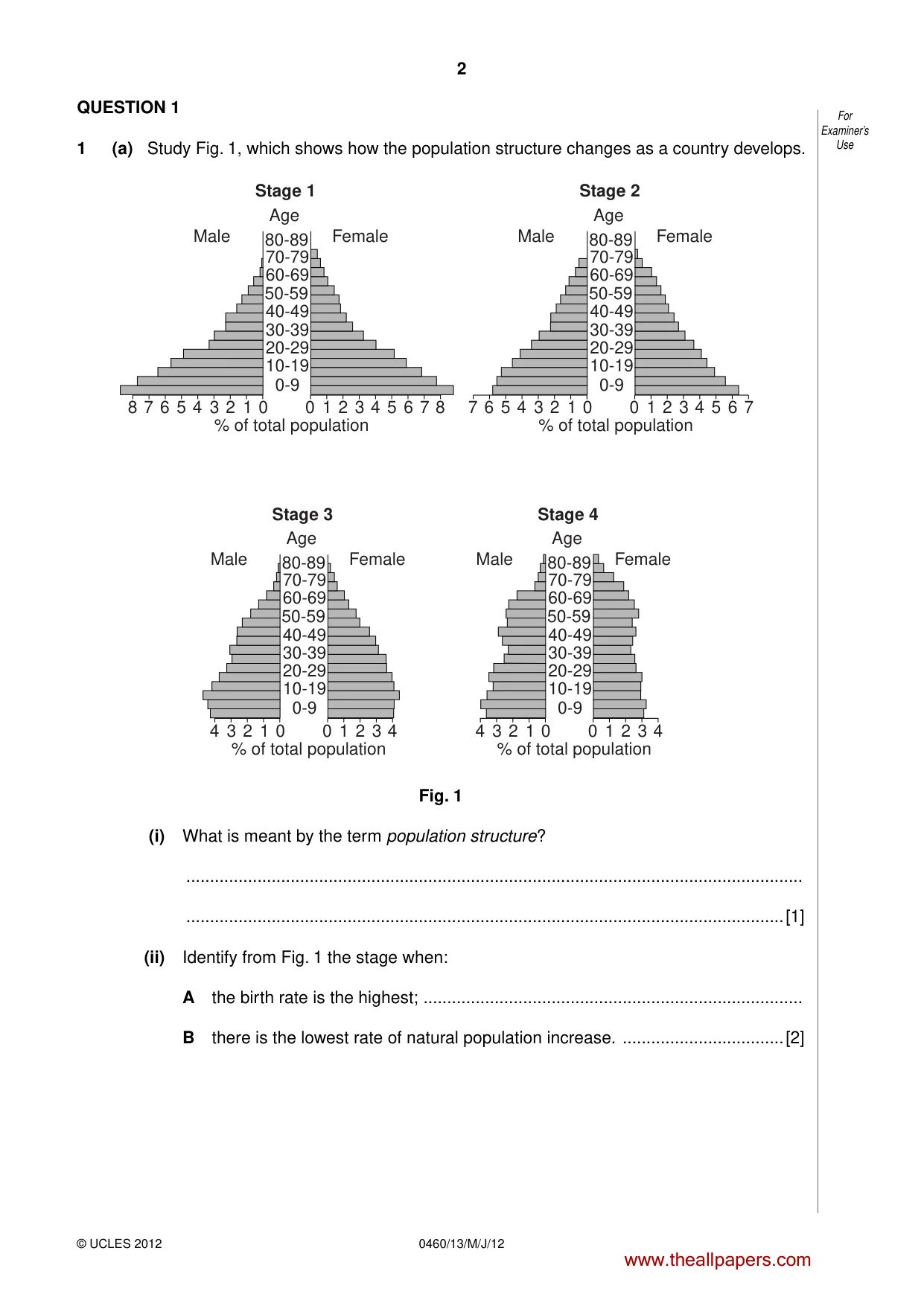
2 0460/13/M/J/12 © UCLES 2012 For Examiner’s Use QUESTION 1 1 (a) Study Fig. 1, which shows how the population structure changes as a country develops. Age 80-89 70-79 60-69 50-59 40-49 30-39 20-29 10-19 0-9 Male Female 8 7 6 5 4 3 2 1 0 0 1 2 3 4 5 6 7 8 Stage 1 % of total population Age 80-89 70-79 60-69 50-59 40-49 30-39 20-29 10-19 0-9 Male Female 7 6 5 4 3 2 1 0 0 1 2 3 4 5 6 7 Stage 2 % of total population Age 80-89 70-79 60-69 50-59 40-49 30-39 20-29 10-19 0-9 Male Female 4 3 2 1 0 0 1 2 3 4 Stage 3 % of total population Age 80-89 70-79 60-69 50-59 40-49 30-39 20-29 10-19 0-9 Male Female 4 3 2 1 0 0 1 2 3 4 Stage 4 % of total population Fig. 1 (i) What is meant by the term population structure? … …[1] (ii) Identify from Fig. 1 the stage when: A the birth rate is the highest; … B there is the lowest rate of natural population increase. …[2] www.theallpapers.com
Question paper, page 3
3 0460/13/M/J/12 © UCLES 2012 [Turn over For Examiner’s Use (iii) Describe three changes in the population structure of a country between Stages 2 and 3. 1 … … 2 … … 3 … …[3] (iv) Explain why the population structure of a country changes as a country develops. … … … … … … … …[4] www.theallpapers.com
Question paper, page 4
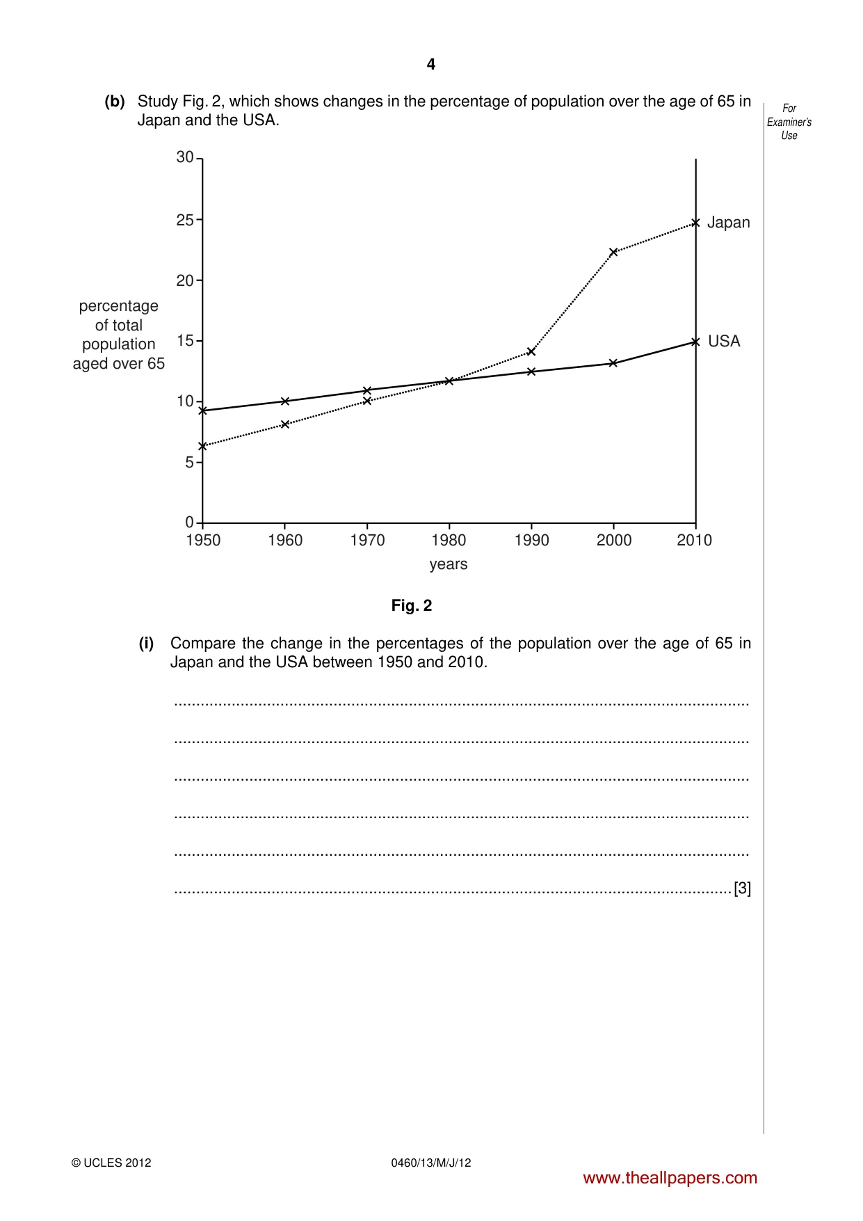
4 0460/13/M/J/12 © UCLES 2012 For Examiner’s Use (b) Study Fig. 2, which shows changes in the percentage of population over the age of 65 in Japan and the USA. 1950 1960 1970 1980 1990 2000 2010 0 5 10 15 20 25 30 Japan USA percentage of total population aged over 65 years Fig. 2 (i) Compare the change in the percentages of the population over the age of 65 in Japan and the USA between 1950 and 2010. … … … … … …[3] www.theallpapers.com
Question paper, page 5
5 0460/13/M/J/12 © UCLES 2012 [Turn over For Examiner’s Use (ii) Explain how people over the age of 65 can be supported in MEDCs. … … … … … … … … … …[5] (c) For a named country which you have studied, describe the problems caused by an increase in the percentage of the population over the age of 65. Name of country… … … … … … … … … … … … … … …[7] [Total: 25 marks] END OF QUESTION 1 www.theallpapers.com
Question paper, page 6
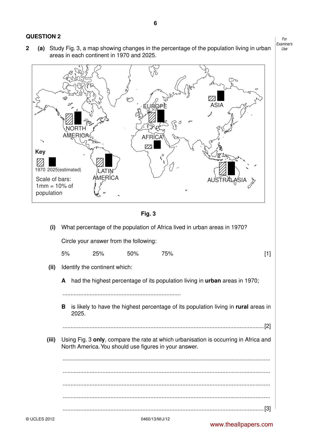
6 0460/13/M/J/12 © UCLES 2012 For Examiner’s Use QUESTION 2 2 (a) Study Fig. 3, a map showing changes in the percentage of the population living in urban areas in each continent in 1970 and 2025. 1970 2025(estimated) Key Scale of bars: 1mm = 10% of population ASIA AUSTRALASIA AUSTRALASIA AFRICA EUROPE EUROPE LATIN AMERICA LATIN AMERICA NORTH AMERICA NORTH AMERICA Fig. 3 (i) What percentage of the population of Africa lived in urban areas in 1970? Circle your answer from the following: 5% 25% 50% 75% [1] (ii) Identify the continent which: A had the highest percentage of its population living in urban areas in 1970; … B is likely to have the highest percentage of its population living in rural areas in 2025. …[2] (iii) Using Fig. 3 only, compare the rate at which urbanisation is occurring in Africa and North America. You should use figures in your answer. … … … … …[3] www.theallpapers.com
Question paper, page 7
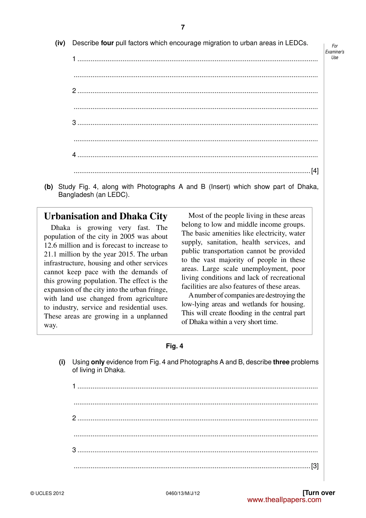
7 0460/13/M/J/12 © UCLES 2012 [Turn over For Examiner’s Use (iv) Describe four pull factors which encourage migration to urban areas in LEDCs. 1 … … 2 … … 3 … … 4 … …[4] (b) Study Fig. 4, along with Photographs A and B (Insert) which show part of Dhaka, Bangladesh (an LEDC). Urbanisation and Dhaka City Dhaka is growing very fast. The population of the city in 2005 was about 12.6 million and is forecast to increase to 21.1 million by the year 2015. The urban infrastructure, housing and other services cannot keep pace with the demands of this growing population. The effect is the expansion of the city into the urban fringe, with land use changed from agriculture to industry, service and residential uses. These areas are growing in a unplanned way. Most of the people living in these areas belong to low and middle income groups. The basic amenities like electricity, water supply, sanitation, health services, and public transportation cannot be provided to the vast majority of people in these areas. Large scale unemployment, poor living conditions and lack of recreational facilities are also features of these areas. A number of companies are destroying the low-lying areas and wetlands for housing. This will create fl ooding in the central part of Dhaka within a very short time. Fig. 4 (i) Using only evidence from Fig. 4 and Photographs A and B, describe three problems of living in Dhaka. 1 … … 2 … … 3 … …[3] www.theallpapers.com
Question paper, page 8
8 0460/13/M/J/12 © UCLES 2012 For Examiner’s Use (ii) Explain how the quality of life of residents in cities like Dhaka is being improved. … … … … … … … … … …[5] (c) For a named example of a town or city in an MEDC which you have studied, describe the problems which occur in the rural-urban fringe as a result of urban sprawl. Name of MEDC city… … … … … … … … … … … … … … …[7] [Total: 25 marks] END OF QUESTION 2 www.theallpapers.com
Question paper, page 9
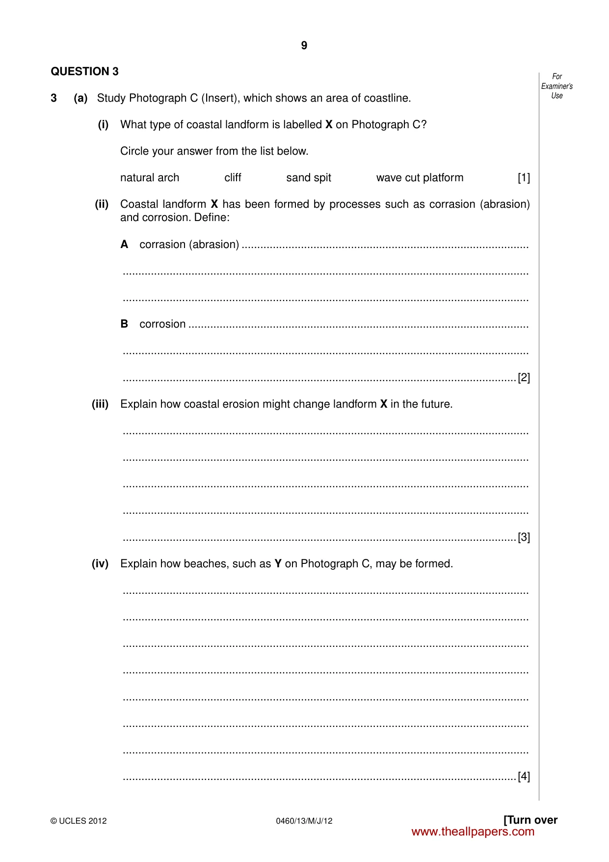
9 0460/13/M/J/12 © UCLES 2012 [Turn over For Examiner’s Use QUESTION 3 3 (a) Study Photograph C (Insert), which shows an area of coastline. (i) What type of coastal landform is labelled X on Photograph C? Circle your answer from the list below. natural arch cliff sand spit wave cut platform [1] (ii) Coastal landform X has been formed by processes such as corrasion (abrasion) and corrosion. Define: A corrasion (abrasion) … … … B corrosion … … …[2] (iii) Explain how coastal erosion might change landform X in the future. … … … … …[3] (iv) Explain how beaches, such as Y on Photograph C, may be formed. … … … … … … … …[4] www.theallpapers.com
Question paper, page 10
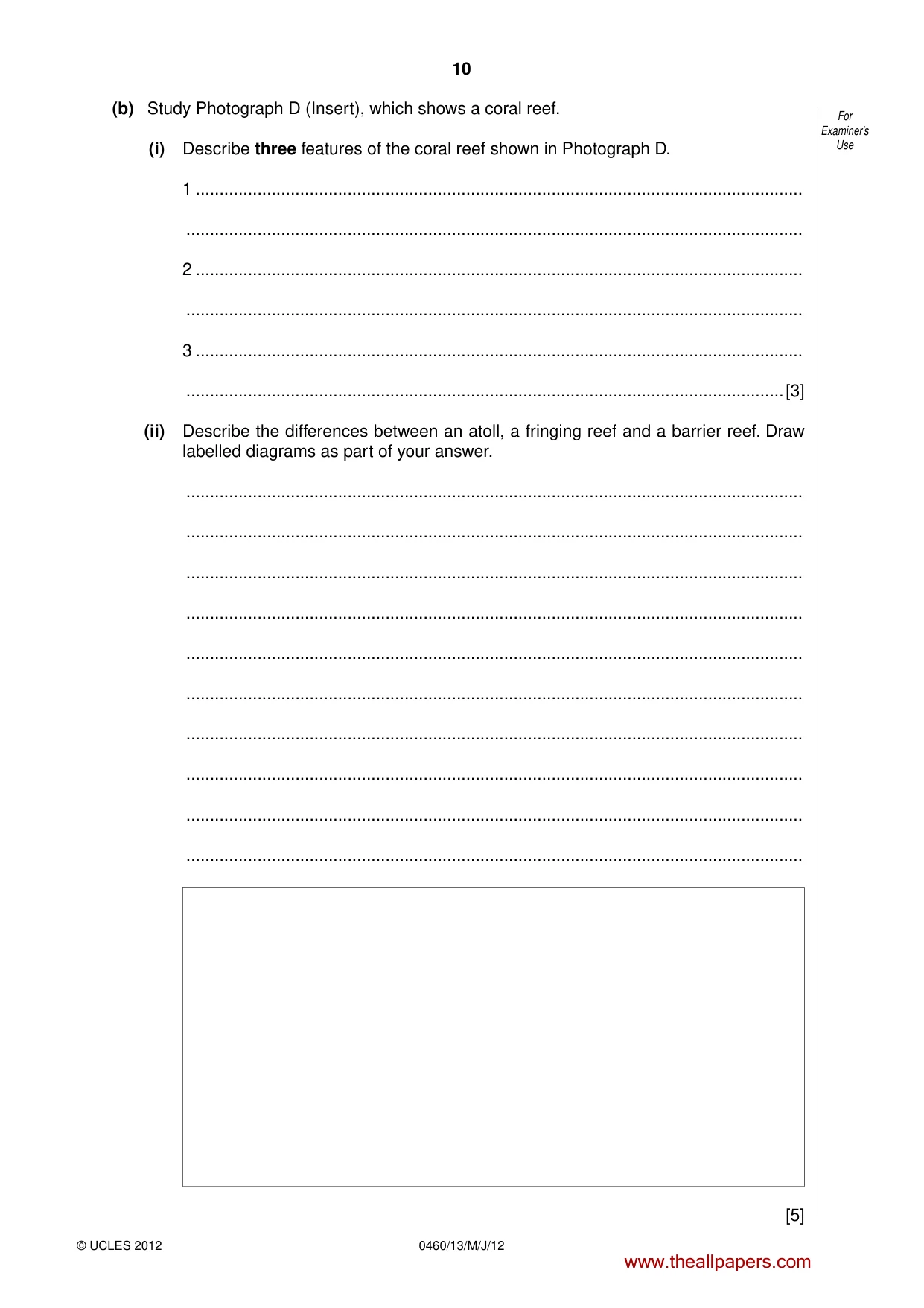
10 0460/13/M/J/12 © UCLES 2012 For Examiner’s Use (b) Study Photograph D (Insert), which shows a coral reef. (i) Describe three features of the coral reef shown in Photograph D. 1 … … 2 … … 3 … …[3] (ii) Describe the differences between an atoll, a fringing reef and a barrier reef. Draw labelled diagrams as part of your answer. … … … … … … … … … … [5] www.theallpapers.com
Question paper, page 11
11 0460/13/M/J/12 © UCLES 2012 [Turn over For Examiner’s Use (c) For a named area of coral reef which you have studied, describe the conditions which led to its formation. Name of area of coral reef… … … … … … … … … … … … … … …[7] [Total: 25 marks] END OF QUESTION 3 www.theallpapers.com
Question paper, page 12
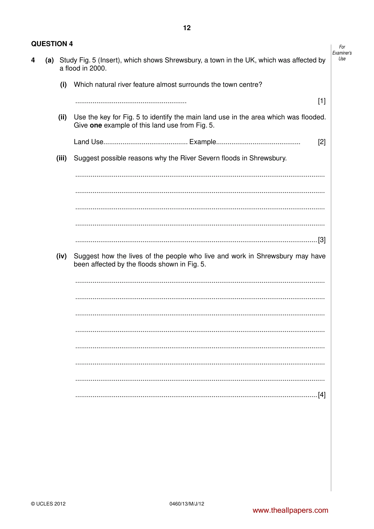
12 0460/13/M/J/12 © UCLES 2012 For Examiner’s Use QUESTION 4 4 (a) Study Fig. 5 (Insert), which shows Shrewsbury, a town in the UK, which was affected by a flood in 2000. (i) Which natural river feature almost surrounds the town centre? … [1] (ii) Use the key for Fig. 5 to identify the main land use in the area which was flooded. Give one example of this land use from Fig. 5. Land Use… Example… [2] (iii) Suggest possible reasons why the River Severn floods in Shrewsbury. … … … … …[3] (iv) Suggest how the lives of the people who live and work in Shrewsbury may have been affected by the floods shown in Fig. 5. … … … … … … … …[4] www.theallpapers.com
Question paper, page 13
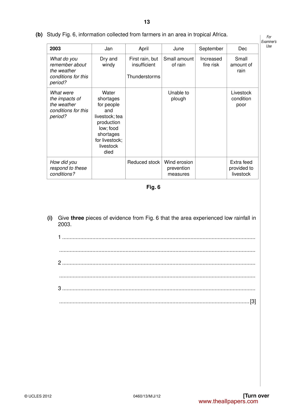
13 0460/13/M/J/12 © UCLES 2012 [Turn over For Examiner’s Use (b) Study Fig. 6, information collected from farmers in an area in tropical Africa. 2003 Jan April June September Dec What do you remember about the weather conditions for this period? Dry and windy First rain, but insufficient Thunderstorms Small amount of rain Increased fire risk Small amount of rain What were the impacts of the weather conditions for this period? Water shortages for people and livestock; tea production low; food shortages for livestock; livestock died Unable to plough Livestock condition poor How did you respond to these conditions? Reduced stock Wind erosion prevention measures Extra feed provided to livestock Fig. 6 (i) Give three pieces of evidence from Fig. 6 that the area experienced low rainfall in 2003. 1 … … 2 … … 3 … …[3] www.theallpapers.com
Question paper, page 14
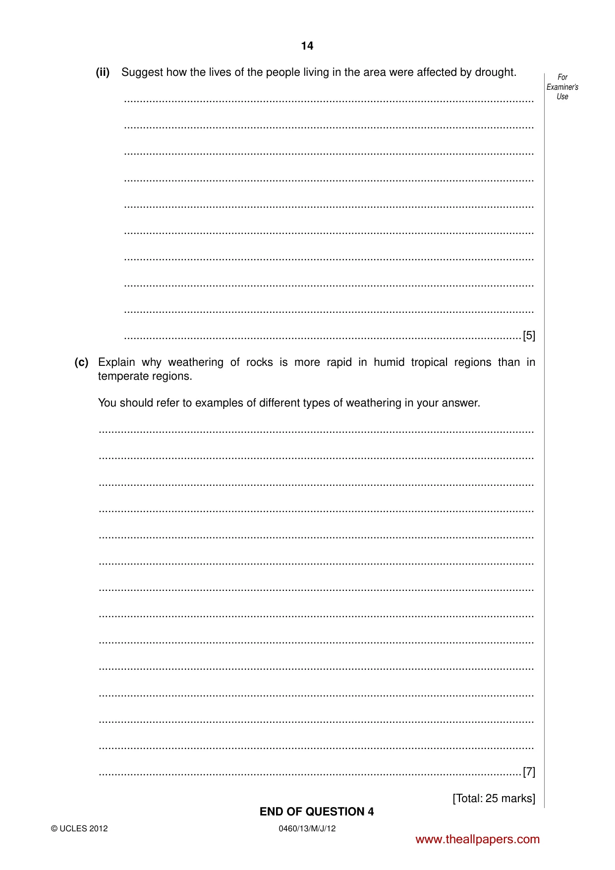
14 0460/13/M/J/12 © UCLES 2012 For Examiner’s Use (ii) Suggest how the lives of the people living in the area were affected by drought. … … … … … … … … … …[5] (c) Explain why weathering of rocks is more rapid in humid tropical regions than in temperate regions. You should refer to examples of different types of weathering in your answer. … … … … … … … … … … … … … …[7] [Total: 25 marks] END OF QUESTION 4 www.theallpapers.com
Question paper, page 15
15 0460/13/M/J/12 © UCLES 2012 [Turn over BLANK PAGE PLEASE TURN OVER FOR QUESTION 5 www.theallpapers.com
Question paper, page 16
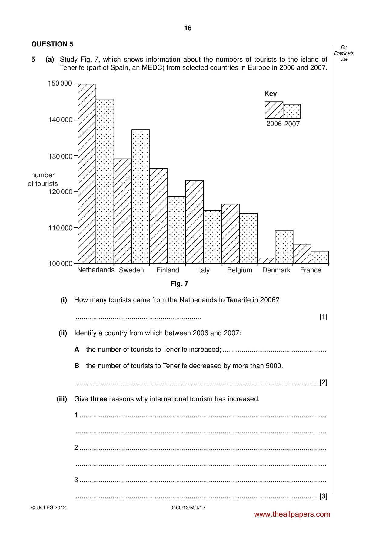
16 0460/13/M/J/12 © UCLES 2012 For Examiner’s Use QUESTION 5 5 (a) Study Fig. 7, which shows information about the numbers of tourists to the island of Tenerife (part of Spain, an MEDC) from selected countries in Europe in 2006 and 2007. Key 150 000 140 000 130 000 120 000 110 000 100 000 Netherlands Sweden Finland Italy Belgium Denmark France 2006 2007 number of tourists Fig. 7 (i) How many tourists came from the Netherlands to Tenerife in 2006? … [1] (ii) Identify a country from which between 2006 and 2007: A the number of tourists to Tenerife increased; … B the number of tourists to Tenerife decreased by more than 5000. …[2] (iii) Give three reasons why international tourism has increased. 1 … … 2 … … 3 … …[3] www.theallpapers.com
Question paper, page 17
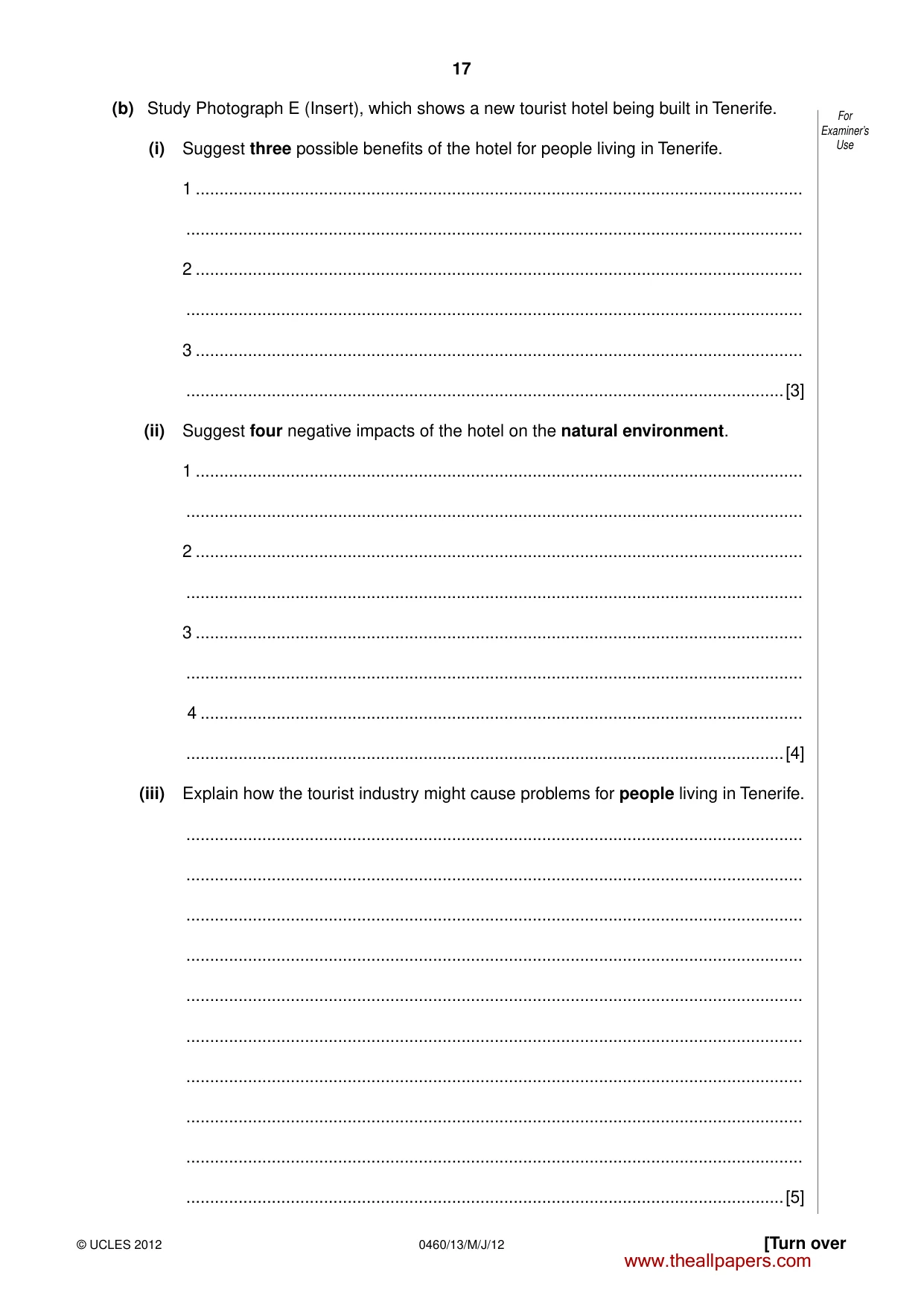
17 0460/13/M/J/12 © UCLES 2012 [Turn over For Examiner’s Use (b) Study Photograph E (Insert), which shows a new tourist hotel being built in Tenerife. (i) Suggest three possible benefits of the hotel for people living in Tenerife. 1 … … 2 … … 3 … …[3] (ii) Suggest four negative impacts of the hotel on the natural environment. 1 … … 2 … … 3 … … 4 … …[4] (iii) Explain how the tourist industry might cause problems for people living in Tenerife. … … … … … … … … … …[5] www.theallpapers.com
Question paper, page 18
18 0460/13/M/J/12 © UCLES 2012 For Examiner’s Use (c) For a named area which you have studied, explain how physical and human factors have encouraged the growth of the tourist industry. Name of area … … … … … … … … … … … … … … …[7] [Total: 25 marks] END OF QUESTION 5 www.theallpapers.com
Question paper, page 19
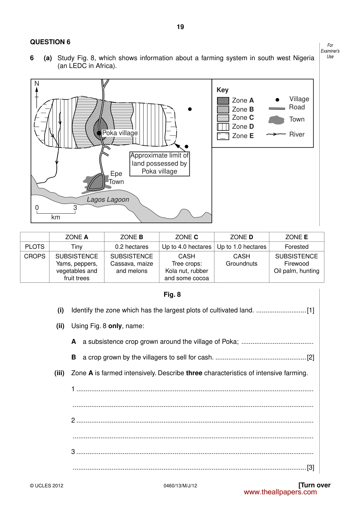
19 0460/13/M/J/12 © UCLES 2012 [Turn over For Examiner’s Use QUESTION 6 6 (a) Study Fig. 8, which shows information about a farming system in south west Nigeria (an LEDC in Africa). 0 3 km Epe Town Lagos Lagoon Approximate limit of land possessed by Poka village N Poka village Zone A Zone B Zone C Zone D Zone E Village Road Town River Key ZONE A ZONE B ZONE C ZONE D ZONE E PLOTS Tiny 0.2 hectares Up to 4.0 hectares Up to 1.0 hectares Forested CROPS SUBSISTENCE Yams, peppers, vegetables and fruit trees SUBSISTENCE Cassava, maize and melons CASH Tree crops: Kola nut, rubber and some cocoa CASH Groundnuts SUBSISTENCE Firewood Oil palm, hunting Fig. 8 (i) Identify the zone which has the largest plots of cultivated land. …[1] (ii) Using Fig. 8 only, name: A a subsistence crop grown around the village of Poka; … B a crop grown by the villagers to sell for cash. …[2] (iii) Zone A is farmed intensively. Describe three characteristics of intensive farming. 1 … … 2 … … 3 … …[3] www.theallpapers.com
Question paper, page 20
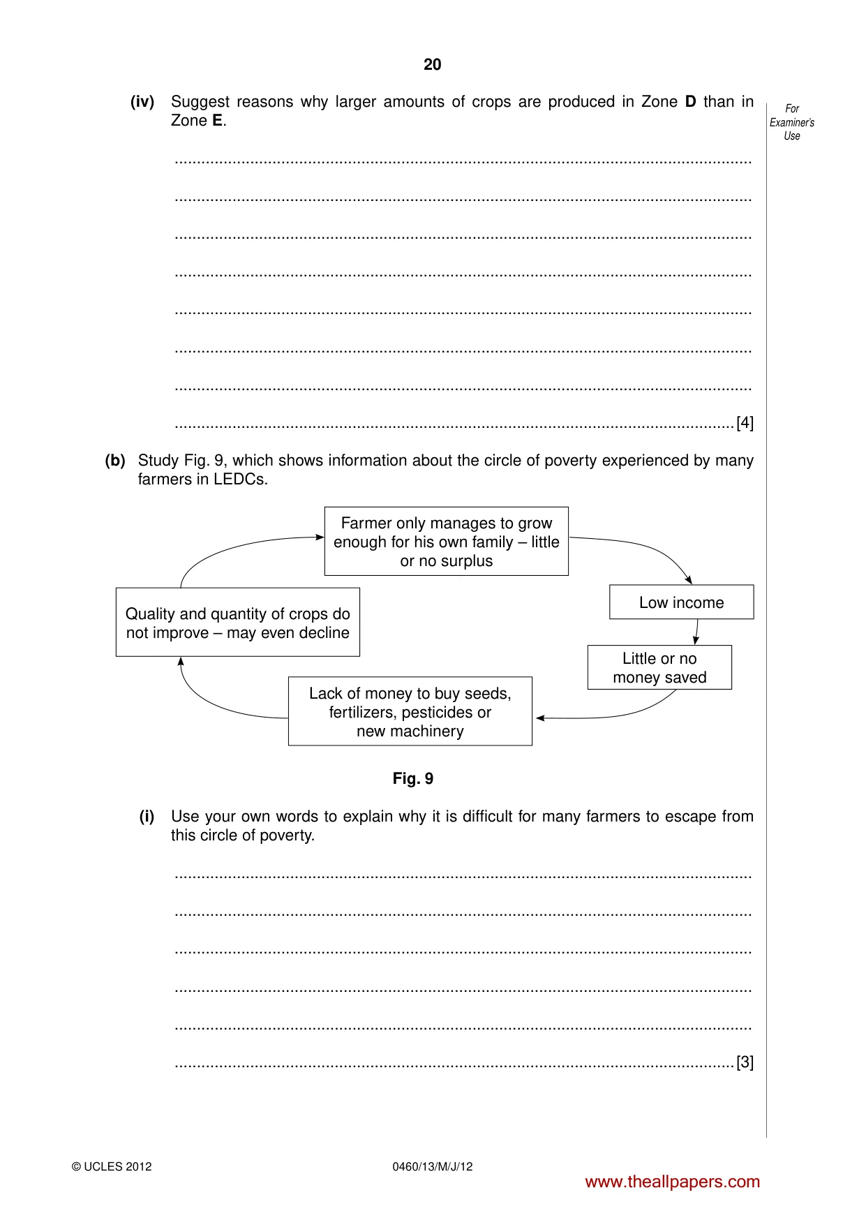
20 0460/13/M/J/12 © UCLES 2012 For Examiner’s Use (iv) Suggest reasons why larger amounts of crops are produced in Zone D than in Zone E. … … … … … … … …[4] (b) Study Fig. 9, which shows information about the circle of poverty experienced by many farmers in LEDCs. Farmer only manages to grow enough for his own family – little or no surplus Lack of money to buy seeds, fertilizers, pesticides or new machinery Quality and quantity of crops do not improve – may even decline Little or no money saved Low income Fig. 9 (i) Use your own words to explain why it is difficult for many farmers to escape from this circle of poverty. … … … … … …[3] www.theallpapers.com
Question paper, page 21
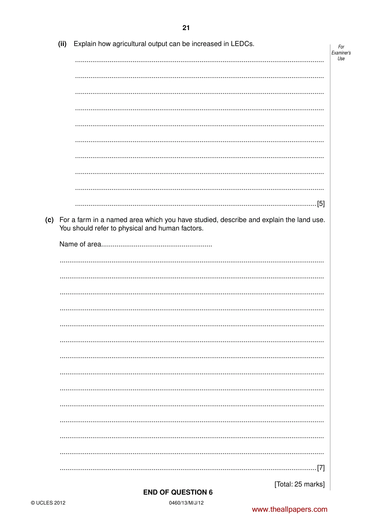
21 0460/13/M/J/12 © UCLES 2012 For Examiner’s Use (ii) Explain how agricultural output can be increased in LEDCs. … … … … … … … … … …[5] (c) For a farm in a named area which you have studied, describe and explain the land use. You should refer to physical and human factors. Name of area… … … … … … … … … … … … … … …[7] [Total: 25 marks] END OF QUESTION 6 www.theallpapers.com
Question paper, page 22
22 0460/13/M/J/12 © UCLES 2012 For Examiner’s Use Additional Page If you use the following lined page to complete the answer(s) to any question(s), the question number(s) must be clearly shown. … … … … … … … … … … … … … … … … … … … … … … … … … … www.theallpapers.com
Question paper, page 23
23 0460/13/M/J/12 © UCLES 2012 BLANK PAGE www.theallpapers.com
Question paper, page 24
24 0460/13/M/J/12 © UCLES 2012 Copyright Acknowledgements: Question 2 Figure 4 © ADAPTED; Star Weekend Magazine. Question 2 Photographs A and B Steve Sibley © UCLES. Question 3 Photograph C Steve Sibley © UCLES. Question 3 Photograph D © Coral Reef; http://ahsansyed.com/wp-content/uploads/2009/06/w-great-barrier-reef1.jpg. Question 4 Figure 6 © ADAPTED; Geography; The Geographical Association; Summer 2008. Question 5 Photograph E Steve Sibley © UCLES. Permission to reproduce items where third-party owned material protected by copyright is included has been sought and cleared where possible. Every reasonable effort has been made by the publisher (UCLES) to trace copyright holders, but if any items requiring clearance have unwittingly been included, the publisher will be pleased to make amends at the earliest possible opportunity. University of Cambridge International Examinations is part of the Cambridge Assessment Group. Cambridge Assessment is the brand name of University of Cambridge Local Examinations Syndicate (UCLES), which is itself a department of the University of Cambridge. BLANK PAGE www.theallpapers.com
Mark scheme, page 1
UNIVERSITY OF CAMBRIDGE INTERNATIONAL EXAMINATIONS International General Certificate of Secondary Education MARK SCHEME for the May/June 2012 question paper for the guidance of teachers 0460 GEOGRAPHY 0460/13 Paper 1, maximum raw mark 75 This mark scheme is published as an aid to teachers and candidates, to indicate the requirements of the examination. It shows the basis on which Examiners were instructed to award marks. It does not indicate the details of the discussions that took place at an Examiners’ meeting before marking began, which would have considered the acceptability of alternative answers. Mark schemes must be read in conjunction with the question papers and the report on the examination. • Cambridge will not enter into discussions or correspondence in connection with these mark schemes. Cambridge is publishing the mark schemes for the May/June 2012 question papers for most IGCSE, GCE Advanced Level and Advanced Subsidiary Level syllabuses and some Ordinary Level syllabuses. www.theallpapers.com
Mark scheme, page 2
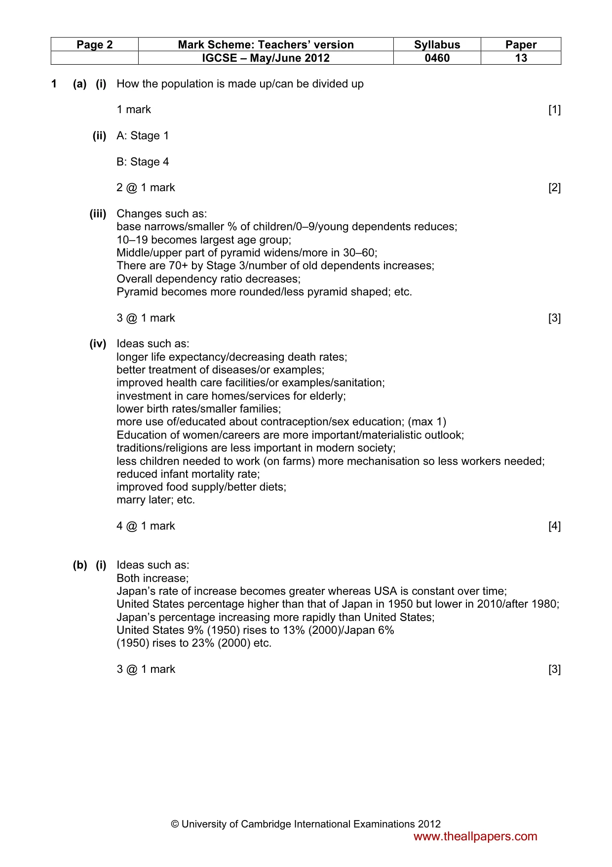
Page 2 Mark Scheme: Teachers’ version Syllabus Paper IGCSE – May/June 2012 0460 13 © University of Cambridge International Examinations 2012 1 (a) (i) How the population is made up/can be divided up 1 mark [1] (ii) A: Stage 1 B: Stage 4 2 @ 1 mark [2] (iii) Changes such as: base narrows/smaller % of children/0–9/young dependents reduces; 10–19 becomes largest age group; Middle/upper part of pyramid widens/more in 30–60; There are 70+ by Stage 3/number of old dependents increases; Overall dependency ratio decreases; Pyramid becomes more rounded/less pyramid shaped; etc. 3 @ 1 mark [3] (iv) Ideas such as: longer life expectancy/decreasing death rates; better treatment of diseases/or examples; improved health care facilities/or examples/sanitation; investment in care homes/services for elderly; lower birth rates/smaller families; more use of/educated about contraception/sex education; (max 1) Education of women/careers are more important/materialistic outlook; traditions/religions are less important in modern society; less children needed to work (on farms) more mechanisation so less workers needed; reduced infant mortality rate; improved food supply/better diets; marry later; etc. 4 @ 1 mark [4] (b) (i) Ideas such as: Both increase; Japan’s rate of increase becomes greater whereas USA is constant over time; United States percentage higher than that of Japan in 1950 but lower in 2010/after 1980; Japan’s percentage increasing more rapidly than United States; United States 9% (1950) rises to 13% (2000)/Japan 6% (1950) rises to 23% (2000) etc. 3 @ 1 mark [3] www.theallpapers.com
Mark scheme, page 3
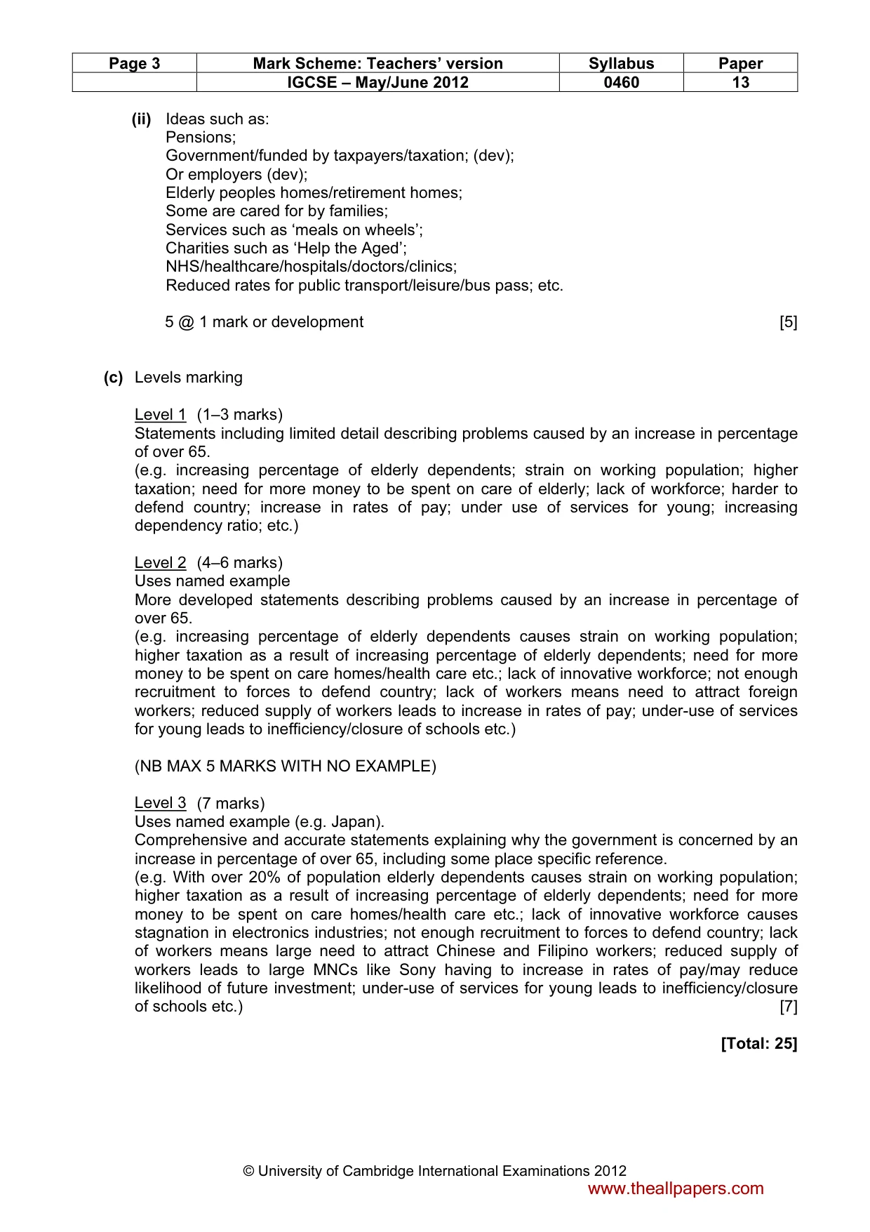
Page 3 Mark Scheme: Teachers’ version Syllabus Paper IGCSE – May/June 2012 0460 13 © University of Cambridge International Examinations 2012 (ii) Ideas such as: Pensions; Government/funded by taxpayers/taxation; (dev); Or employers (dev); Elderly peoples homes/retirement homes; Some are cared for by families; Services such as ‘meals on wheels’; Charities such as ‘Help the Aged’; NHS/healthcare/hospitals/doctors/clinics; Reduced rates for public transport/leisure/bus pass; etc. 5 @ 1 mark or development [5] (c) Levels marking Level 1 (1–3 marks) Statements including limited detail describing problems caused by an increase in percentage of over 65. (e.g. increasing percentage of elderly dependents; strain on working population; higher taxation; need for more money to be spent on care of elderly; lack of workforce; harder to defend country; increase in rates of pay; under use of services for young; increasing dependency ratio; etc.) Level 2 (4–6 marks) Uses named example More developed statements describing problems caused by an increase in percentage of over 65. (e.g. increasing percentage of elderly dependents causes strain on working population; higher taxation as a result of increasing percentage of elderly dependents; need for more money to be spent on care homes/health care etc.; lack of innovative workforce; not enough recruitment to forces to defend country; lack of workers means need to attract foreign workers; reduced supply of workers leads to increase in rates of pay; under-use of services for young leads to inefficiency/closure of schools etc.) (NB MAX 5 MARKS WITH NO EXAMPLE) Level 3 (7 marks) Uses named example (e.g. Japan). Comprehensive and accurate statements explaining why the government is concerned by an increase in percentage of over 65, including some place specific reference. (e.g. With over 20% of population elderly dependents causes strain on working population; higher taxation as a result of increasing percentage of elderly dependents; need for more money to be spent on care homes/health care etc.; lack of innovative workforce causes stagnation in electronics industries; not enough recruitment to forces to defend country; lack of workers means large need to attract Chinese and Filipino workers; reduced supply of workers leads to large MNCs like Sony having to increase in rates of pay/may reduce likelihood of future investment; under-use of services for young leads to inefficiency/closure of schools etc.) [7] [Total: 25] www.theallpapers.com
Mark scheme, page 4
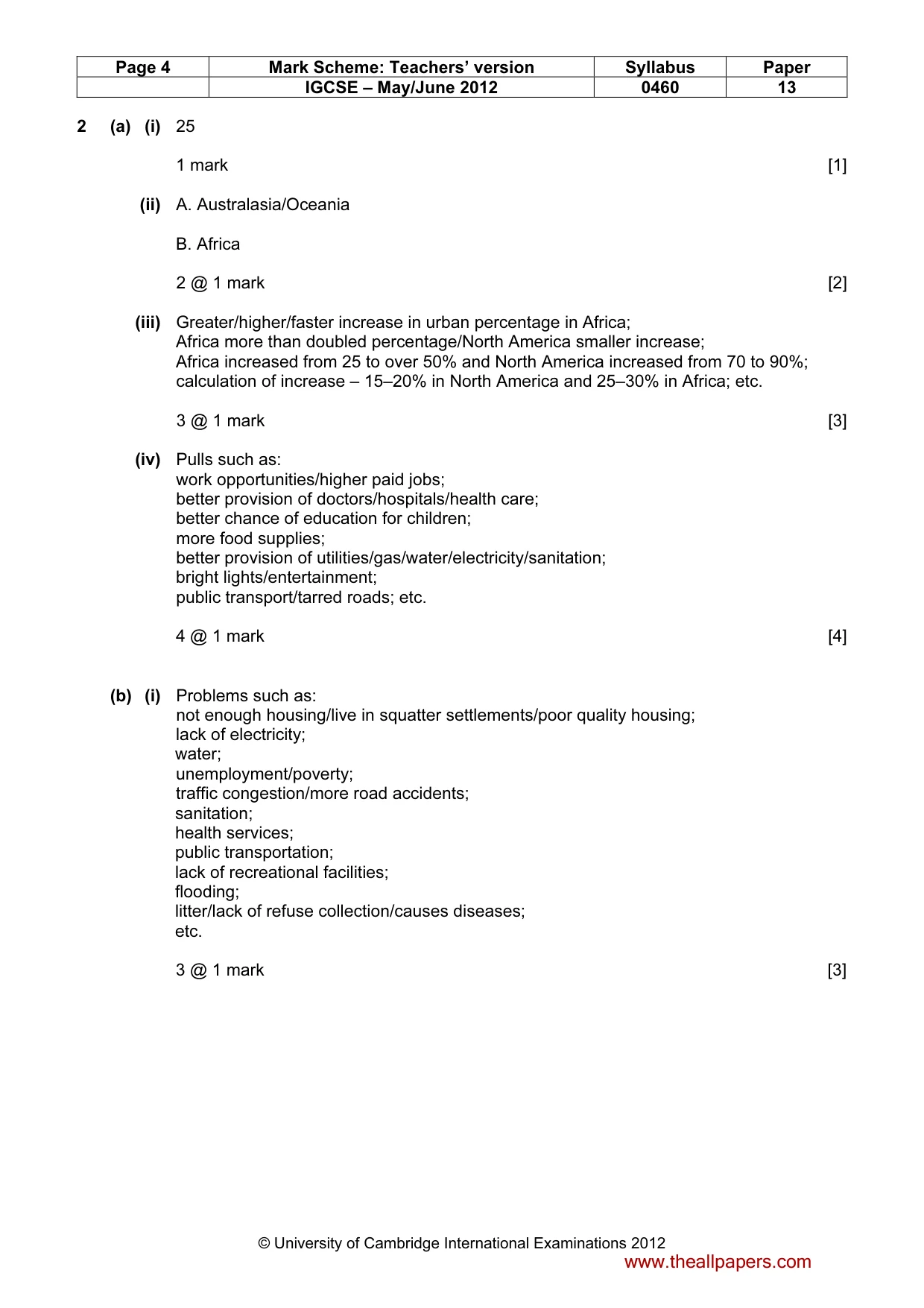
Page 4 Mark Scheme: Teachers’ version Syllabus Paper IGCSE – May/June 2012 0460 13 © University of Cambridge International Examinations 2012 2 (a) (i) 25 1 mark [1] (ii) A. Australasia/Oceania B. Africa 2 @ 1 mark [2] (iii) Greater/higher/faster increase in urban percentage in Africa; Africa more than doubled percentage/North America smaller increase; Africa increased from 25 to over 50% and North America increased from 70 to 90%; calculation of increase – 15–20% in North America and 25–30% in Africa; etc. 3 @ 1 mark [3] (iv) Pulls such as: work opportunities/higher paid jobs; better provision of doctors/hospitals/health care; better chance of education for children; more food supplies; better provision of utilities/gas/water/electricity/sanitation; bright lights/entertainment; public transport/tarred roads; etc. 4 @ 1 mark [4] (b) (i) Problems such as: not enough housing/live in squatter settlements/poor quality housing; lack of electricity; water; unemployment/poverty; traffic congestion/more road accidents; sanitation; health services; public transportation; lack of recreational facilities; flooding; litter/lack of refuse collection/causes diseases; etc. 3 @ 1 mark [3] www.theallpapers.com
Mark scheme, page 5
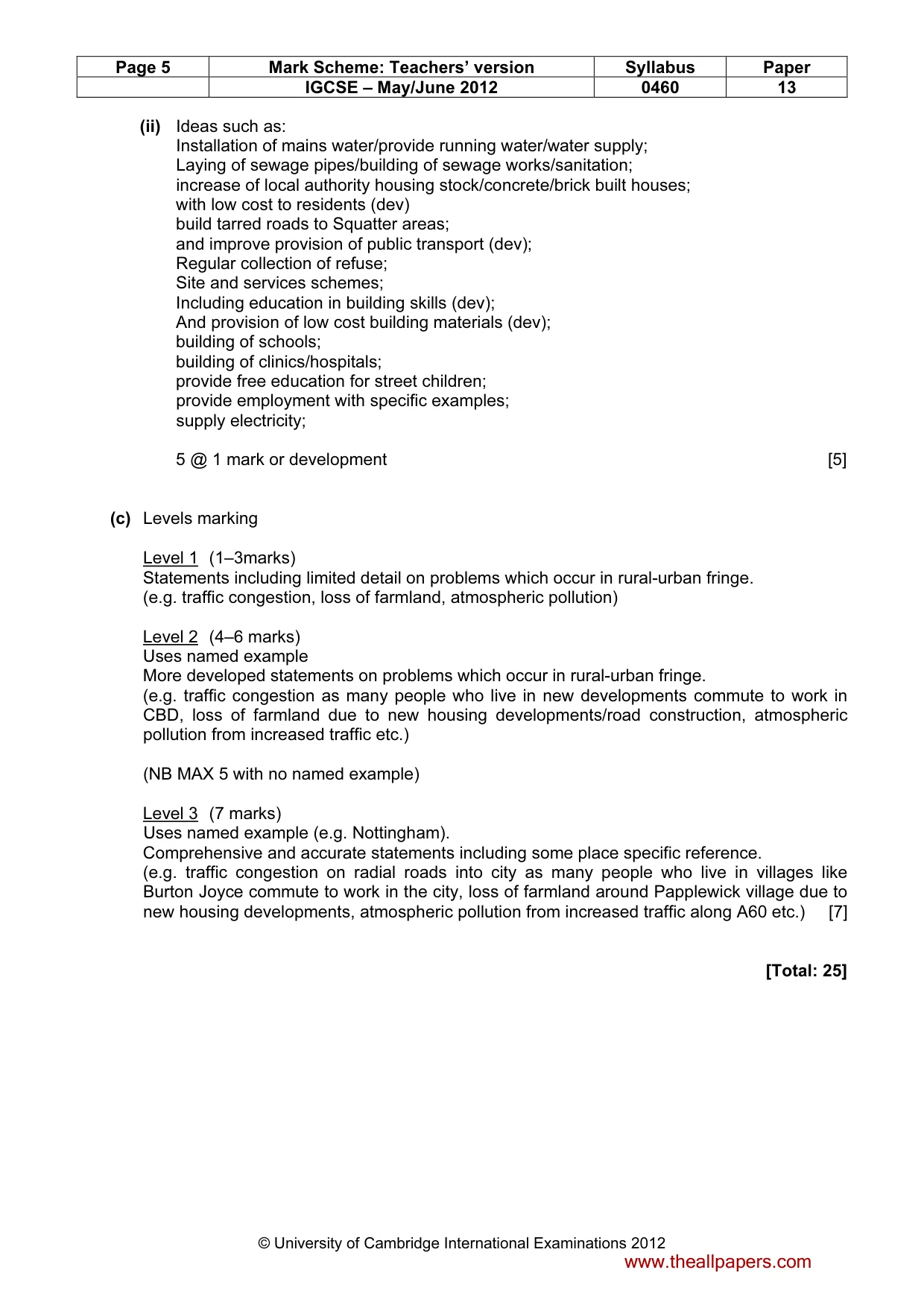
Page 5 Mark Scheme: Teachers’ version Syllabus Paper IGCSE – May/June 2012 0460 13 © University of Cambridge International Examinations 2012 (ii) Ideas such as: Installation of mains water/provide running water/water supply; Laying of sewage pipes/building of sewage works/sanitation; increase of local authority housing stock/concrete/brick built houses; with low cost to residents (dev) build tarred roads to Squatter areas; and improve provision of public transport (dev); Regular collection of refuse; Site and services schemes; Including education in building skills (dev); And provision of low cost building materials (dev); building of schools; building of clinics/hospitals; provide free education for street children; provide employment with specific examples; supply electricity; 5 @ 1 mark or development [5] (c) Levels marking Level 1 (1–3marks) Statements including limited detail on problems which occur in rural-urban fringe. (e.g. traffic congestion, loss of farmland, atmospheric pollution) Level 2 (4–6 marks) Uses named example More developed statements on problems which occur in rural-urban fringe. (e.g. traffic congestion as many people who live in new developments commute to work in CBD, loss of farmland due to new housing developments/road construction, atmospheric pollution from increased traffic etc.) (NB MAX 5 with no named example) Level 3 (7 marks) Uses named example (e.g. Nottingham). Comprehensive and accurate statements including some place specific reference. (e.g. traffic congestion on radial roads into city as many people who live in villages like Burton Joyce commute to work in the city, loss of farmland around Papplewick village due to new housing developments, atmospheric pollution from increased traffic along A60 etc.) [7] [Total: 25] www.theallpapers.com
Mark scheme, page 6
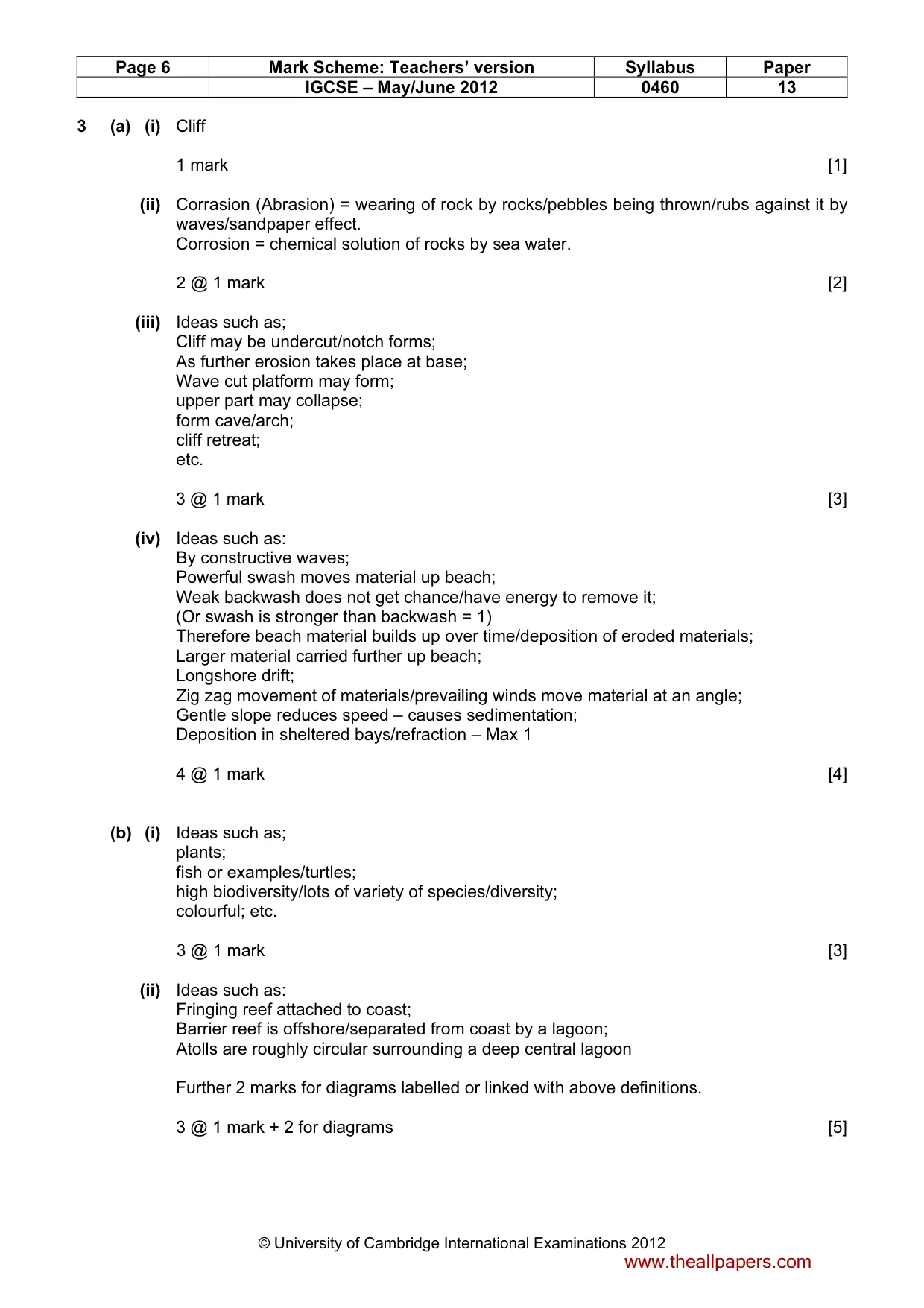
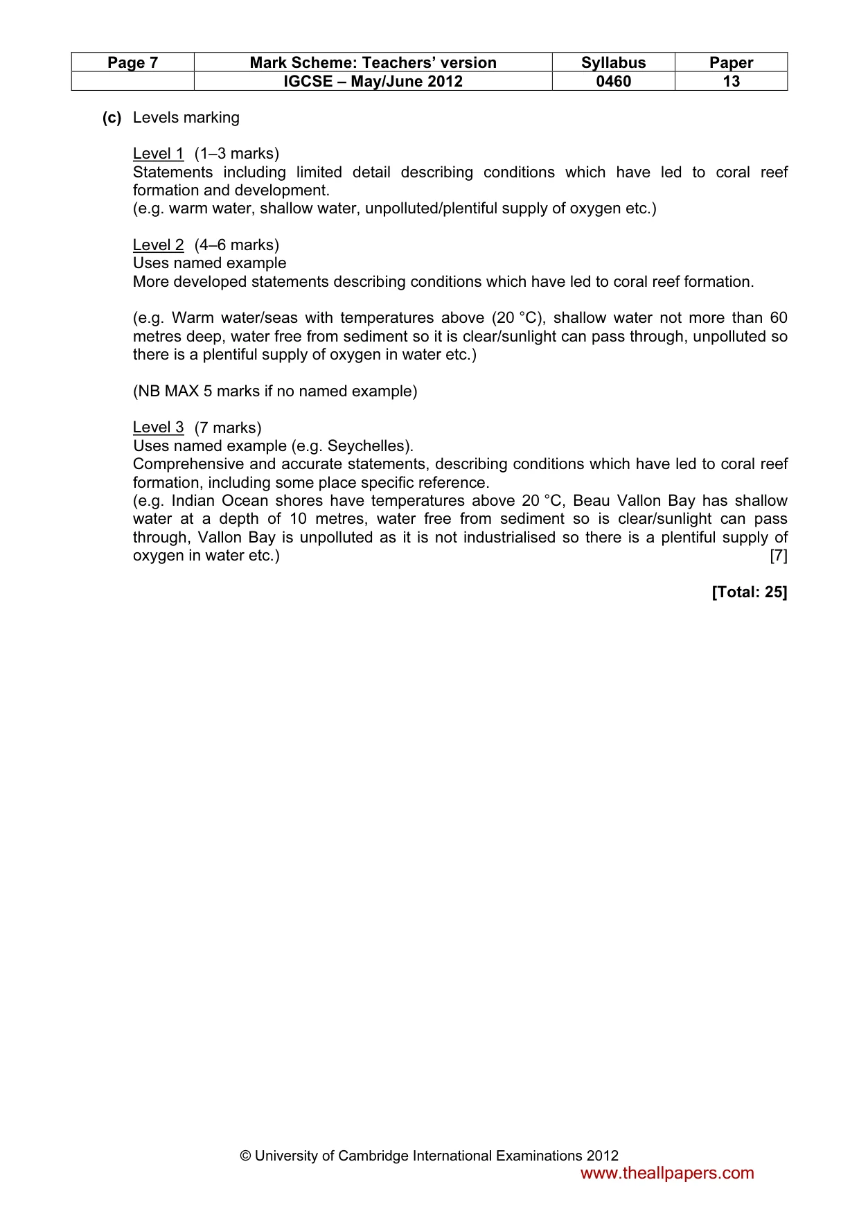
Page 6 Mark Scheme: Teachers’ version Syllabus Paper IGCSE – May/June 2012 0460 13 © University of Cambridge International Examinations 2012 3 (a) (i) Cliff 1 mark [1] (ii) Corrasion (Abrasion) = wearing of rock by rocks/pebbles being thrown/rubs against it by waves/sandpaper effect. Corrosion = chemical solution of rocks by sea water. 2 @ 1 mark [2] (iii) Ideas such as; Cliff may be undercut/notch forms; As further erosion takes place at base; Wave cut platform may form; upper part may collapse; form cave/arch; cliff retreat; etc. 3 @ 1 mark [3] (iv) Ideas such as: By constructive waves; Powerful swash moves material up beach; Weak backwash does not get chance/have energy to remove it; (Or swash is stronger than backwash = 1) Therefore beach material builds up over time/deposition of eroded materials; Larger material carried further up beach; Longshore drift; Zig zag movement of materials/prevailing winds move material at an angle; Gentle slope reduces speed – causes sedimentation; Deposition in sheltered bays/refraction – Max 1 4 @ 1 mark [4] (b) (i) Ideas such as; plants; fish or examples/turtles; high biodiversity/lots of variety of species/diversity; colourful; etc. 3 @ 1 mark [3] (ii) Ideas such as: Fringing reef attached to coast; Barrier reef is offshore/separated from coast by a lagoon; Atolls are roughly circular surrounding a deep central lagoon Further 2 marks for diagrams labelled or linked with above definitions. 3 @ 1 mark + 2 for diagrams [5] www.theallpapers.com
Mark scheme, page 7
Page 7 Mark Scheme: Teachers’ version Syllabus Paper IGCSE – May/June 2012 0460 13 © University of Cambridge International Examinations 2012 (c) Levels marking Level 1 (1–3 marks) Statements including limited detail describing conditions which have led to coral reef formation and development. (e.g. warm water, shallow water, unpolluted/plentiful supply of oxygen etc.) Level 2 (4–6 marks) Uses named example More developed statements describing conditions which have led to coral reef formation. (e.g. Warm water/seas with temperatures above (20 °C), shallow water not more than 60 metres deep, water free from sediment so it is clear/sunlight can pass through, unpolluted so there is a plentiful supply of oxygen in water etc.) (NB MAX 5 marks if no named example) Level 3 (7 marks) Uses named example (e.g. Seychelles). Comprehensive and accurate statements, describing conditions which have led to coral reef formation, including some place specific reference. (e.g. Indian Ocean shores have temperatures above 20 °C, Beau Vallon Bay has shallow water at a depth of 10 metres, water free from sediment so is clear/sunlight can pass through, Vallon Bay is unpolluted as it is not industrialised so there is a plentiful supply of oxygen in water etc.) [7] [Total: 25] www.theallpapers.com
Mark scheme, page 8
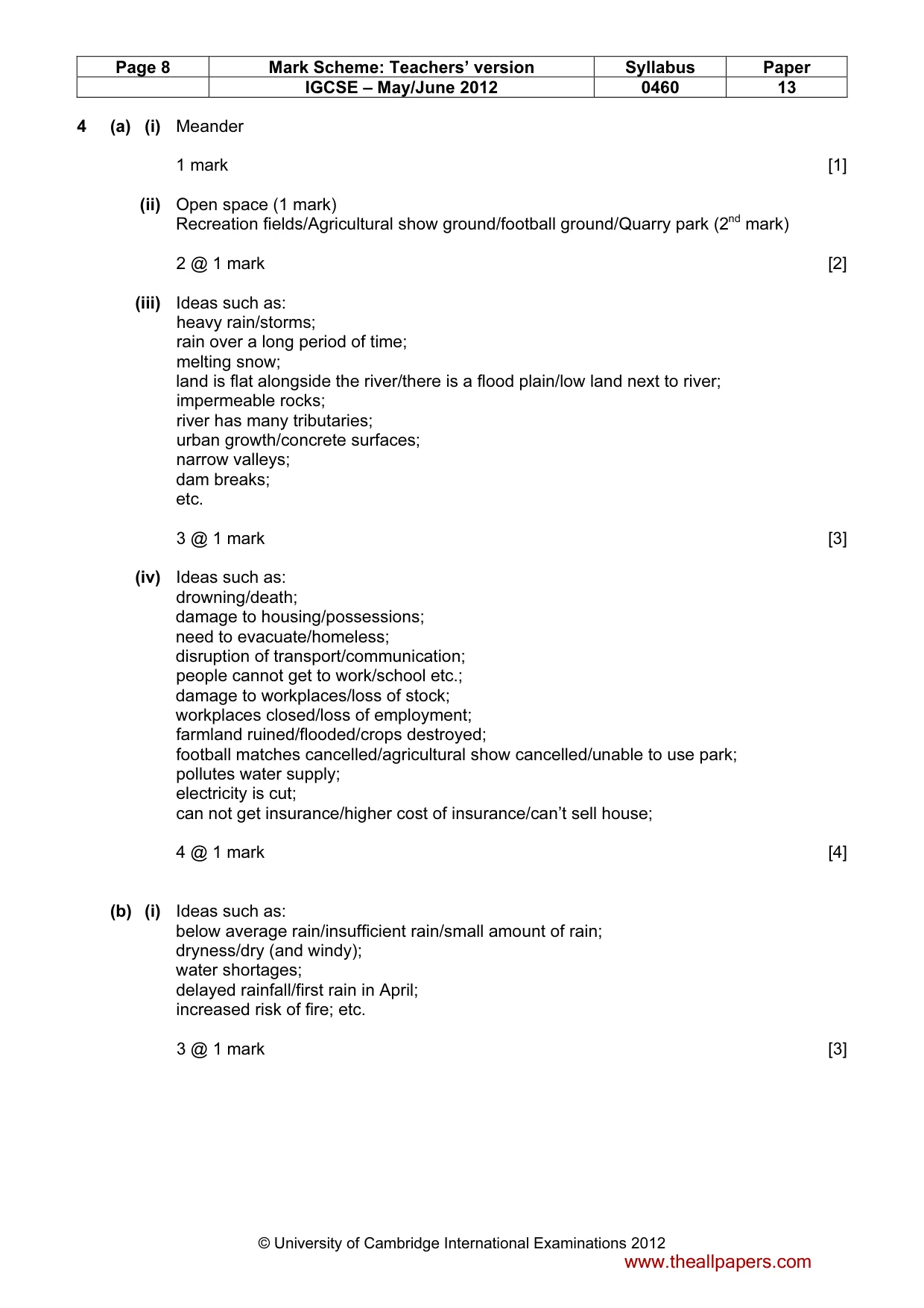
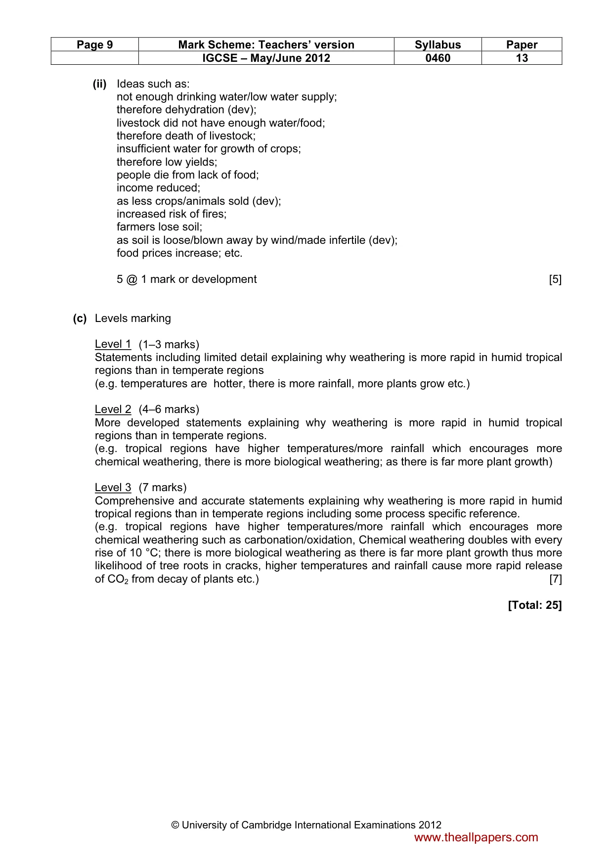
Page 8 Mark Scheme: Teachers’ version Syllabus Paper IGCSE – May/June 2012 0460 13 © University of Cambridge International Examinations 2012 4 (a) (i) Meander 1 mark [1] (ii) Open space (1 mark) Recreation fields/Agricultural show ground/football ground/Quarry park (2nd mark) 2 @ 1 mark [2] (iii) Ideas such as: heavy rain/storms; rain over a long period of time; melting snow; land is flat alongside the river/there is a flood plain/low land next to river; impermeable rocks; river has many tributaries; urban growth/concrete surfaces; narrow valleys; dam breaks; etc. 3 @ 1 mark [3] (iv) Ideas such as: drowning/death; damage to housing/possessions; need to evacuate/homeless; disruption of transport/communication; people cannot get to work/school etc.; damage to workplaces/loss of stock; workplaces closed/loss of employment; farmland ruined/flooded/crops destroyed; football matches cancelled/agricultural show cancelled/unable to use park; pollutes water supply; electricity is cut; can not get insurance/higher cost of insurance/can’t sell house; 4 @ 1 mark [4] (b) (i) Ideas such as: below average rain/insufficient rain/small amount of rain; dryness/dry (and windy); water shortages; delayed rainfall/first rain in April; increased risk of fire; etc. 3 @ 1 mark [3] www.theallpapers.com
Mark scheme, page 9
Page 9 Mark Scheme: Teachers’ version Syllabus Paper IGCSE – May/June 2012 0460 13 © University of Cambridge International Examinations 2012 (ii) Ideas such as: not enough drinking water/low water supply; therefore dehydration (dev); livestock did not have enough water/food; therefore death of livestock; insufficient water for growth of crops; therefore low yields; people die from lack of food; income reduced; as less crops/animals sold (dev); increased risk of fires; farmers lose soil; as soil is loose/blown away by wind/made infertile (dev); food prices increase; etc. 5 @ 1 mark or development [5] (c) Levels marking Level 1 (1–3 marks) Statements including limited detail explaining why weathering is more rapid in humid tropical regions than in temperate regions (e.g. temperatures are hotter, there is more rainfall, more plants grow etc.) Level 2 (4–6 marks) More developed statements explaining why weathering is more rapid in humid tropical regions than in temperate regions. (e.g. tropical regions have higher temperatures/more rainfall which encourages more chemical weathering, there is more biological weathering; as there is far more plant growth) Level 3 (7 marks) Comprehensive and accurate statements explaining why weathering is more rapid in humid tropical regions than in temperate regions including some process specific reference. (e.g. tropical regions have higher temperatures/more rainfall which encourages more chemical weathering such as carbonation/oxidation, Chemical weathering doubles with every rise of 10 °C; there is more biological weathering as there is far more plant growth thus more likelihood of tree roots in cracks, higher temperatures and rainfall cause more rapid release of CO2 from decay of plants etc.) [7] [Total: 25] www.theallpapers.com
Mark scheme, page 10
Page 10 Mark Scheme: Teachers’ version Syllabus Paper IGCSE – May/June 2012 0460 13 © University of Cambridge International Examinations 2012 5 (a) (i) 150 000 1 mark [1] (ii) A = Sweden/Denmark B = Italy/Finland 2 @ 1 mark [2] (iii) Ideas such as: Increasing affluence; developments in travel/larger planes; tourists are being more adventurous; more knowledge about distant locations/internet; increased holiday time/time off work/paid holidays; more advertising; etc. 3 @ 1 mark [3] (b) (i) Ideas such as: employment/or example; development of economy/brings in money; local farmers/fishermen can sell produce; benefits to local transport operators/taxis/or other example; infrastructural developments/electricity/water/sanitation; increased sales of building materials; increased spending by tourists in local shops/restaurants/sell souvenirs; or examples; improvements in road network; etc. 3 @ 1 mark [3] (ii) Ideas such as: natural vegetation/forest/grassland removed for construction; destructions of habitats; vegetation/plant life trampled/killed by people; swimming in sea/boats anchoring could damage corals/rocks; increase disposal of sewage in sea/rubbish in sea; fumes from traffic/air pollution from traffic; lowering of water reserves/water table; noise scares animals; death of fish/sea creatures; specific impact of litter/rubbish left on natural environment; break down of ecosystems/destroys ecosystems; cliff has been cut away to make a road; etc. 4 @ 1 mark [4] www.theallpapers.com
Mark scheme, page 11
Page 11 Mark Scheme: Teachers’ version Syllabus Paper IGCSE – May/June 2012 0460 13 © University of Cambridge International Examinations 2012 (iii) Problems such as: increase in local traffic/traffic congestion/atmospheric pollution; from traffic; hotel could cause visual impact; loss of local culture/traditional way of life; impact of behaviour of tourists/drunkeness etc.; noise disturbs people; exploitation/low paid jobs/long hours; seasonal work; shortage of water supplies; litter from tourists; lack of privacy; loss of farmland for building; visual impact; increases prices in local shops; Government invests more money in tourist areas rather than local housing; etc. 5 @ 1 mark or development [5] (c) Levels marking Level 1 (1–3 marks) Statements including limited detail which briefly describe physical and/or human factors which have encouraged growth of tourist industry. (e.g. hot weather, sunny, low rainfall, nice scenery, beaches, local culture, easy to get to, waterfront restaurants/bars etc.) Level 2 (4–6 marks) Uses named example. More developed statements which explain how physical and/or human factors have encouraged growth of tourist industry. (e.g. long hours of sunshine enable people to sunbathe, high temperatures during summer months encourage tourists from colder climates, low rainfall so tourists can go on the beach, clean blue seas so can do water sports, waterfront restaurants/bars for evening entertainment, attractive headlands with cliffs so people can enjoy a picturesque environment, sheltered sandy bays ideal for sunbathing, ease of access via good roads and airport etc.) (NB MAX 5 marks if no named example) Level 3 (7 marks) Uses named example (e.g. Algarve). Comprehensive and accurate statements, statements which explain how physical and human factors have encouraged growth of tourist industry. (e.g. long hours of sunshine especially from June to September enable people to sunbathe, average temperatures of over 20 °C during summer months encourage tourists from colder climates, low rainfall between April and October so tourists can go on the beach, clean blue seas so can do water sports, waterfront restaurants/bars in resorts like Albufeira for evening entertainment, attractive headlands with cliffs near Lagos so people can enjoy a picturesque environment, sheltered sandy bays ideal for sunbathing, ease of access via good roads and Faro airport) [7] [Total: 25] www.theallpapers.com
Mark scheme, page 12
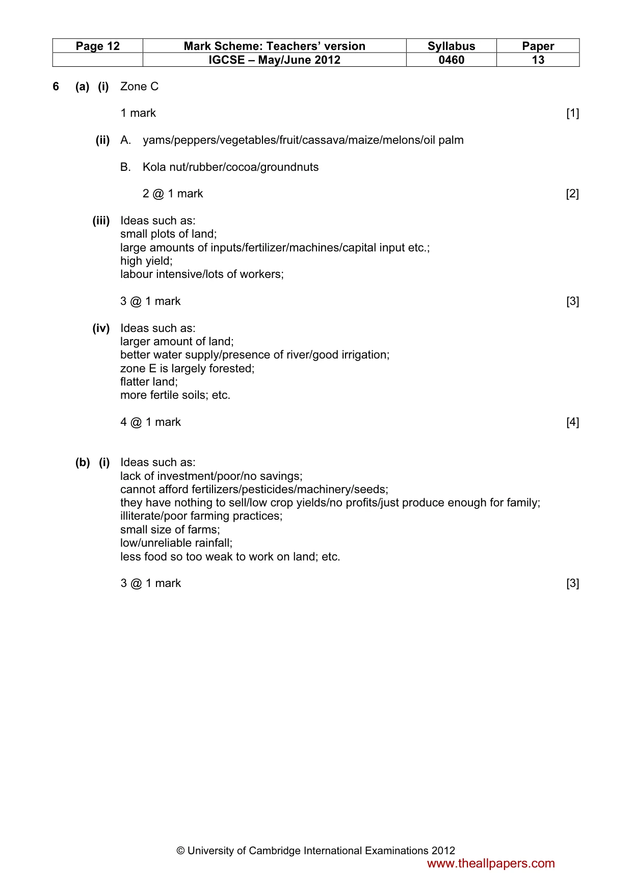
Page 12 Mark Scheme: Teachers’ version Syllabus Paper IGCSE – May/June 2012 0460 13 © University of Cambridge International Examinations 2012 6 (a) (i) Zone C 1 mark [1] (ii) A. yams/peppers/vegetables/fruit/cassava/maize/melons/oil palm B. Kola nut/rubber/cocoa/groundnuts 2 @ 1 mark [2] (iii) Ideas such as: small plots of land; large amounts of inputs/fertilizer/machines/capital input etc.; high yield; labour intensive/lots of workers; 3 @ 1 mark [3] (iv) Ideas such as: larger amount of land; better water supply/presence of river/good irrigation; zone E is largely forested; flatter land; more fertile soils; etc. 4 @ 1 mark [4] (b) (i) Ideas such as: lack of investment/poor/no savings; cannot afford fertilizers/pesticides/machinery/seeds; they have nothing to sell/low crop yields/no profits/just produce enough for family; illiterate/poor farming practices; small size of farms; low/unreliable rainfall; less food so too weak to work on land; etc. 3 @ 1 mark [3] www.theallpapers.com
Mark scheme, page 13
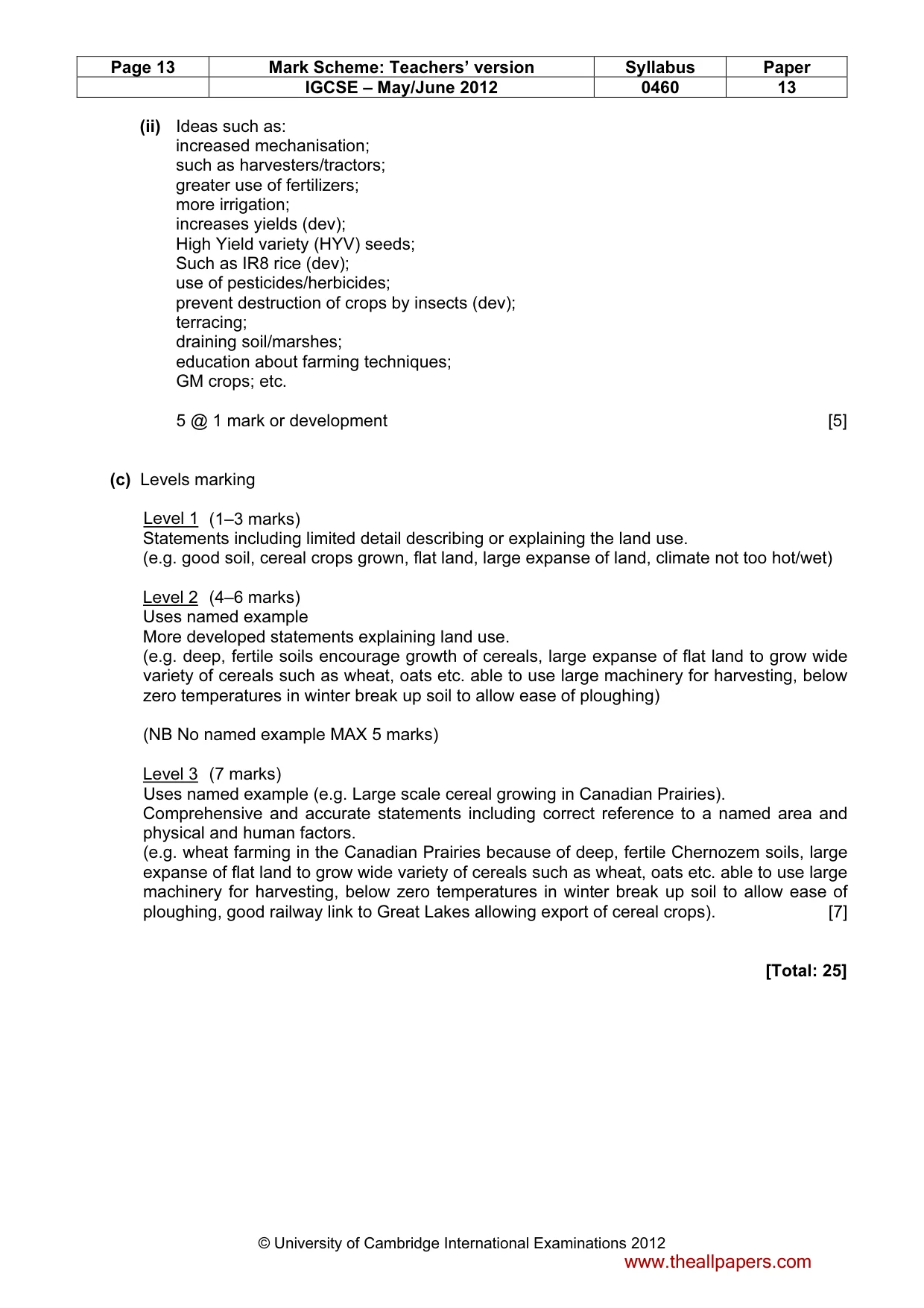
Page 13 Mark Scheme: Teachers’ version Syllabus Paper IGCSE – May/June 2012 0460 13 © University of Cambridge International Examinations 2012 (ii) Ideas such as: increased mechanisation; such as harvesters/tractors; greater use of fertilizers; more irrigation; increases yields (dev); High Yield variety (HYV) seeds; Such as IR8 rice (dev); use of pesticides/herbicides; prevent destruction of crops by insects (dev); terracing; draining soil/marshes; education about farming techniques; GM crops; etc. 5 @ 1 mark or development [5] (c) Levels marking Level 1 (1–3 marks) Statements including limited detail describing or explaining the land use. (e.g. good soil, cereal crops grown, flat land, large expanse of land, climate not too hot/wet) Level 2 (4–6 marks) Uses named example More developed statements explaining land use. (e.g. deep, fertile soils encourage growth of cereals, large expanse of flat land to grow wide variety of cereals such as wheat, oats etc. able to use large machinery for harvesting, below zero temperatures in winter break up soil to allow ease of ploughing) (NB No named example MAX 5 marks) Level 3 (7 marks) Uses named example (e.g. Large scale cereal growing in Canadian Prairies). Comprehensive and accurate statements including correct reference to a named area and physical and human factors. (e.g. wheat farming in the Canadian Prairies because of deep, fertile Chernozem soils, large expanse of flat land to grow wide variety of cereals such as wheat, oats etc. able to use large machinery for harvesting, below zero temperatures in winter break up soil to allow ease of ploughing, good railway link to Great Lakes allowing export of cereal crops). [7] [Total: 25] www.theallpapers.com
What you needed in this session
Cambridge’s own grade thresholds for 2012 May/June, Paper 1 · Variant 3. A higher threshold means an easier paper — the bar moves with how the cohort did.