Cambridge IGCSE Geography 0460 — 2011 May/June Paper 1 · Variant 1
0460/11/M/J/11 · 75 marks · ≈84 min
The question paper and its mark scheme, free to read here and free to download. This is Cambridge’s own paper, exactly as it was sat.
Question paper28 pages


Mark scheme13 pages
Answers below. Sit the paper first if you are practising.
Paper as text
Question paper, page 1
This document consists of 25 printed pages, 3 blank pages and 1 Insert. DC (SM/JG) 31973/8 © UCLES 2011 [Turn over UNIVERSITY OF CAMBRIDGE INTERNATIONAL EXAMINATIONS International General Certificate of Secondary Education * 6 5 7 6 9 1 0 5 3 8 * GEOGRAPHY 0460/11 Paper 1 May/June 2011 1 hour 45 minutes Candidates answer on the Question Paper. Additional Materials: Ruler READ THESE INSTRUCTIONS FIRST Write your Centre number, candidate number and name in the spaces provided. Write in dark blue or black pen. You may use a soft pencil for any diagrams, graphs or rough working. Do not use staples, paper clips, highlighters, glue or correction fluid. DO NOT WRITE ON ANY BARCODES. Write your answer to each question in the space provided. If additional space is required, you should use the lined page at the end of this booklet. The question number(s) must be clearly shown. Answer three questions. The Insert contains Photographs A and B for Question 1. The Insert is not required by the Examiner. Sketch maps and diagrams should be drawn whenever they serve to illustrate an answer. The number of marks is given in brackets [ ] at the end of each question or part question. www.theallpapers.com
Question paper, page 2
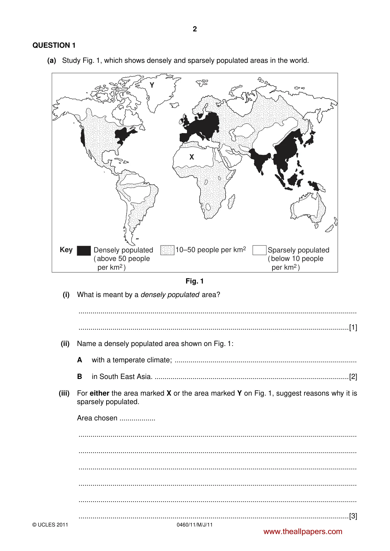
2 0460/11/M/J/11 © UCLES 2011 QUESTION 1 (a) Study Fig. 1, which shows densely and sparsely populated areas in the world. Densely populated ( above 50 people per km2 ) Sparsely populated ( below 10 people per km2 ) 10–50 people per km2 X Y Key Fig. 1 (i) What is meant by a densely populated area? … …[1] (ii) Name a densely populated area shown on Fig. 1: A with a temperate climate; … B in South East Asia. …[2] (iii) For either the area marked X or the area marked Y on Fig. 1, suggest reasons why it is sparsely populated. Area chosen … … … … … … …[3] www.theallpapers.com
Question paper, page 3
3 0460/11/M/J/11 © UCLES 2011 [Turn over (b) Study Photographs A and B (Insert) which show two areas which are sparsely populated. (i) Suggest reasons why the area shown in Photograph A is sparsely populated. … … … … … …[3] (ii) Suggest how the relief of the land shown in Photograph B has resulted in the area being sparsely populated. … … … … … … … …[4] (iii) Explain why some river valleys are densely populated. … … … … … … … … … …[5] www.theallpapers.com
Question paper, page 4
4 0460/11/M/J/11 © UCLES 2011 (c) For a named country which you have studied, describe and explain the distribution of its population. Name of country … … … … … … … … … … … … … … … …[7] [Total: 25 marks] END OF QUESTION 1 www.theallpapers.com
Question paper, page 5
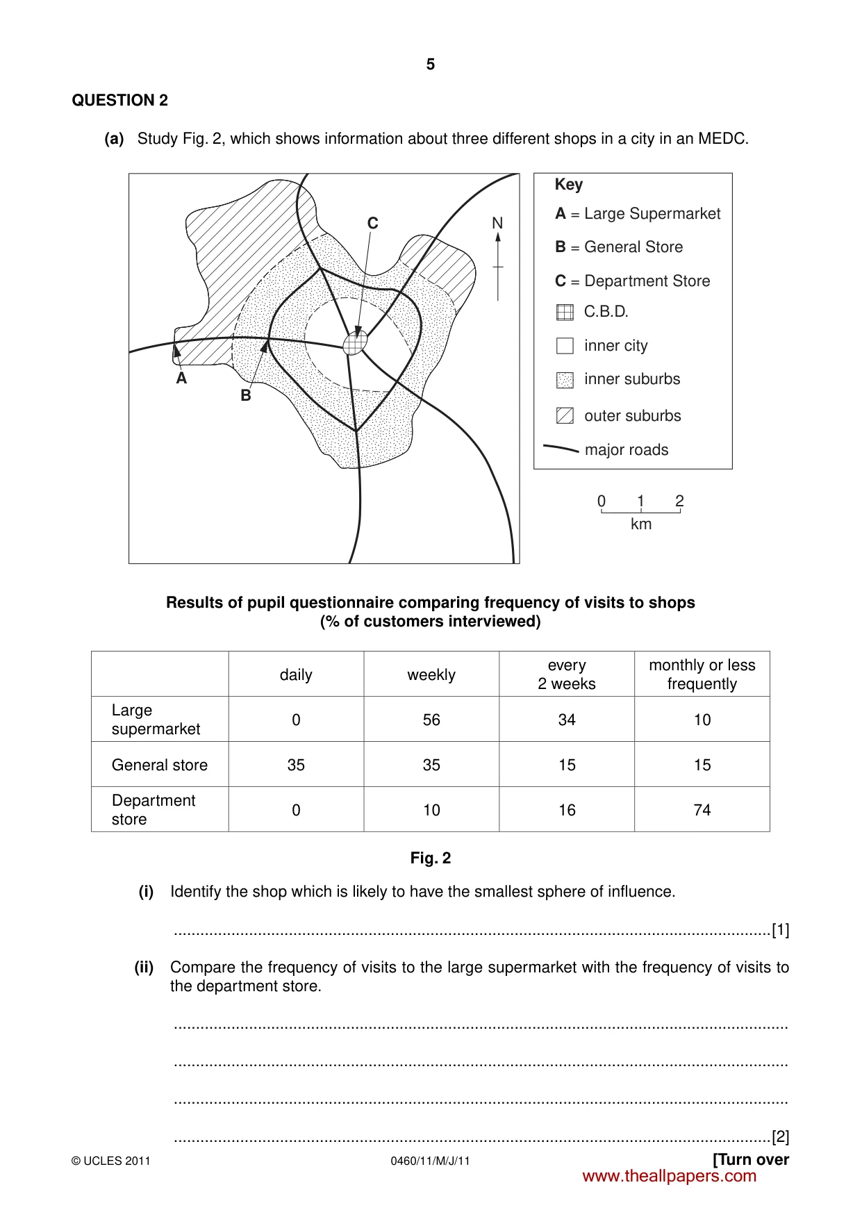
5 0460/11/M/J/11 © UCLES 2011 [Turn over QUESTION 2 (a) Study Fig. 2, which shows information about three different shops in a city in an MEDC. Key C.B.D. inner city inner suburbs outer suburbs major roads 0 1 2 A = Large Supermarket B = General Store C = Department Store C B A km N Results of pupil questionnaire comparing frequency of visits to shops (% of customers interviewed) daily weekly every 2 weeks monthly or less frequently Large supermarket 0 56 34 10 General store 35 35 15 15 Department store 0 10 16 74 Fig. 2 (i) Identify the shop which is likely to have the smallest sphere of influence. …[1] (ii) Compare the frequency of visits to the large supermarket with the frequency of visits to the department store. … … … …[2] www.theallpapers.com
Question paper, page 6
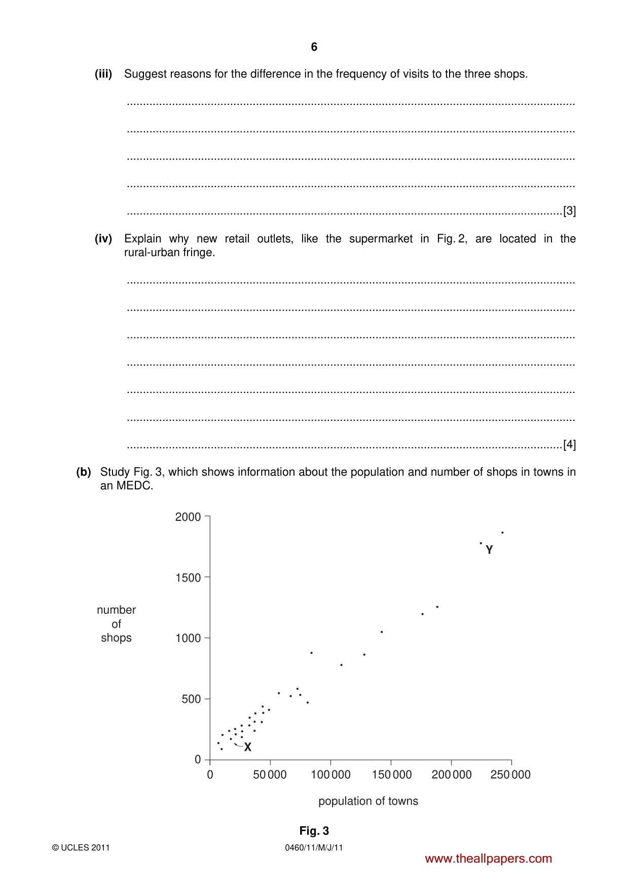
6 0460/11/M/J/11 © UCLES 2011 (iii) Suggest reasons for the difference in the frequency of visits to the three shops. … … … … …[3] (iv) Explain why new retail outlets, like the supermarket in Fig. 2, are located in the rural-urban fringe. … … … … … … …[4] (b) Study Fig. 3, which shows information about the population and number of shops in towns in an MEDC. X Y population of towns number of shops 50 000 100 000 150 000 200 000 250 000 0 0 500 1000 1500 2000 Fig. 3 www.theallpapers.com
Question paper, page 7
7 0460/11/M/J/11 © UCLES 2011 [Turn over (i) What relationship exists between the population of towns and the number of shops? Use data from Fig. 3 in your answer. … … … … …[3] (ii) In what other ways will the shops and shopping areas in town X differ from those in town Y? … … … … … … … … … … … …[5] www.theallpapers.com
Question paper, page 8
8 0460/11/M/J/11 © UCLES 2011 (c) Describe the hierarchy of settlements in a named country or area which you have studied. Country or area … … … … … … … … … … … … … … … …[7] [Total: 25 marks] END OF QUESTION 2 www.theallpapers.com
Question paper, page 9
9 0460/11/M/J/11 © UCLES 2011 [Turn over BLANK PAGE TURN OVER FOR QUESTION 3 www.theallpapers.com
Question paper, page 10
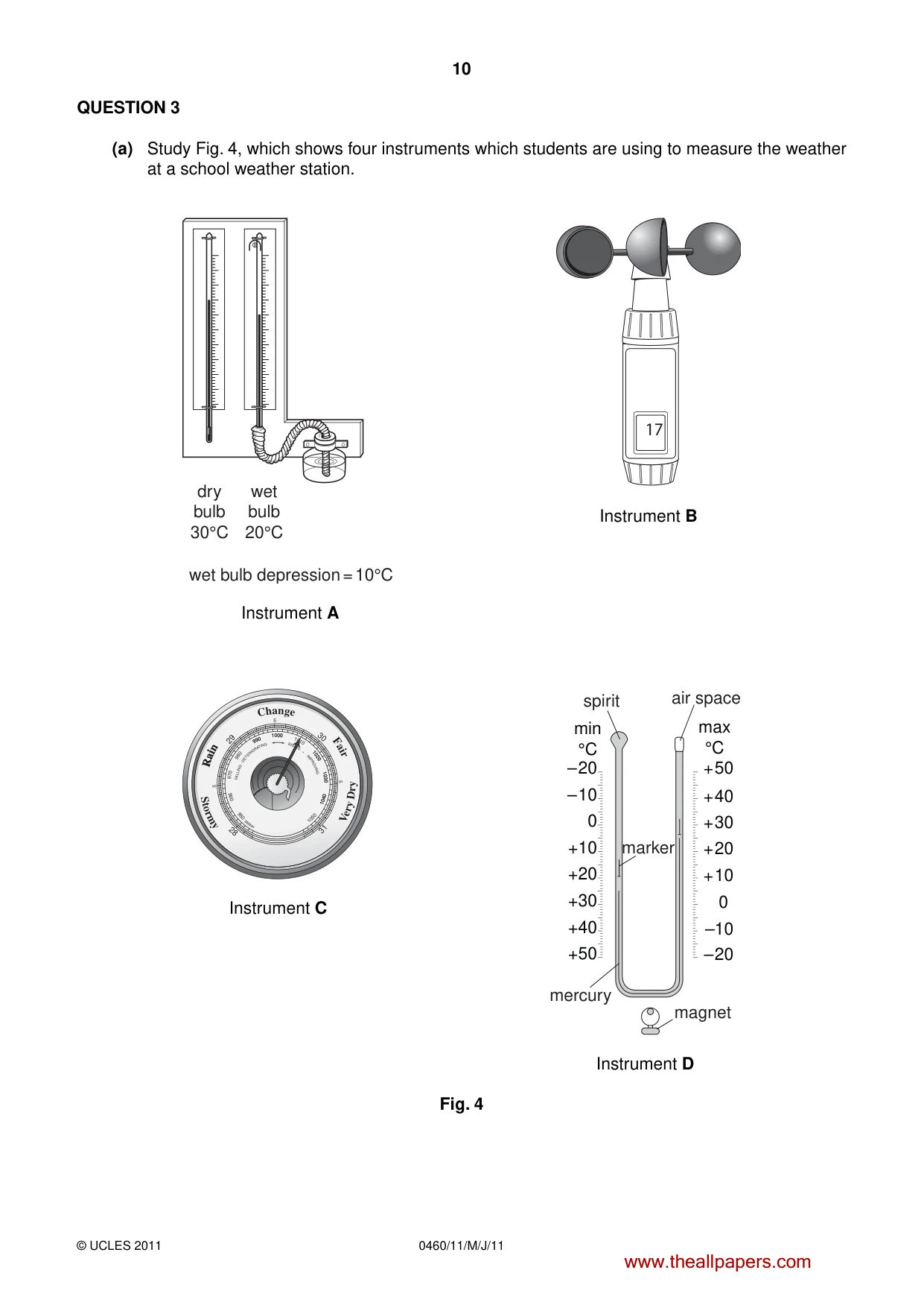
10 0460/11/M/J/11 © UCLES 2011 QUESTION 3 (a) Study Fig. 4, which shows four instruments which students are using to measure the weather at a school weather station. dry bulb 30°C wet bulb 20°C wet bulb depression = 10°C 17 C h a n g e R a i n R a i n F a i r F A L LI N G - D E T E R I O R A TI N G R IS I N G I M P R O VI N G S t o r m y V e r y D r y 1 0 0 0 1 0 1 0 1 0 2 0 1 0 3 0 9 9 0 9 8 0 9 7 0 1 0 4 0 1 0 0 0 1 0 2 0 1 0 3 0 9 9 0 1 0 4 0 1 0 5 0 9 5 0 9 6 0 5 5 5 29 30 28 31 M ill ib ar +40 +30 +50 +20 +10 – 10 – 20 + 50 + 40 + 30 + 20 + 10 0 –10 – 20 min °C max °C 0 spirit air space magnet mercury marker Instrument A Instrument B Instrument C Instrument D Fig. 4 www.theallpapers.com
Question paper, page 11
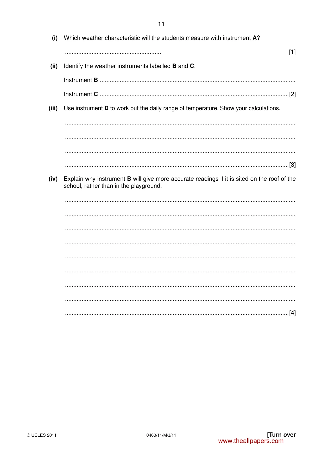
11 0460/11/M/J/11 © UCLES 2011 [Turn over (i) Which weather characteristic will the students measure with instrument A? … [1] (ii) Identify the weather instruments labelled B and C. Instrument B … Instrument C …[2] (iii) Use instrument D to work out the daily range of temperature. Show your calculations. … … … …[3] (iv) Explain why instrument B will give more accurate readings if it is sited on the roof of the school, rather than in the playground. … … … … … … … … …[4] www.theallpapers.com
Question paper, page 12
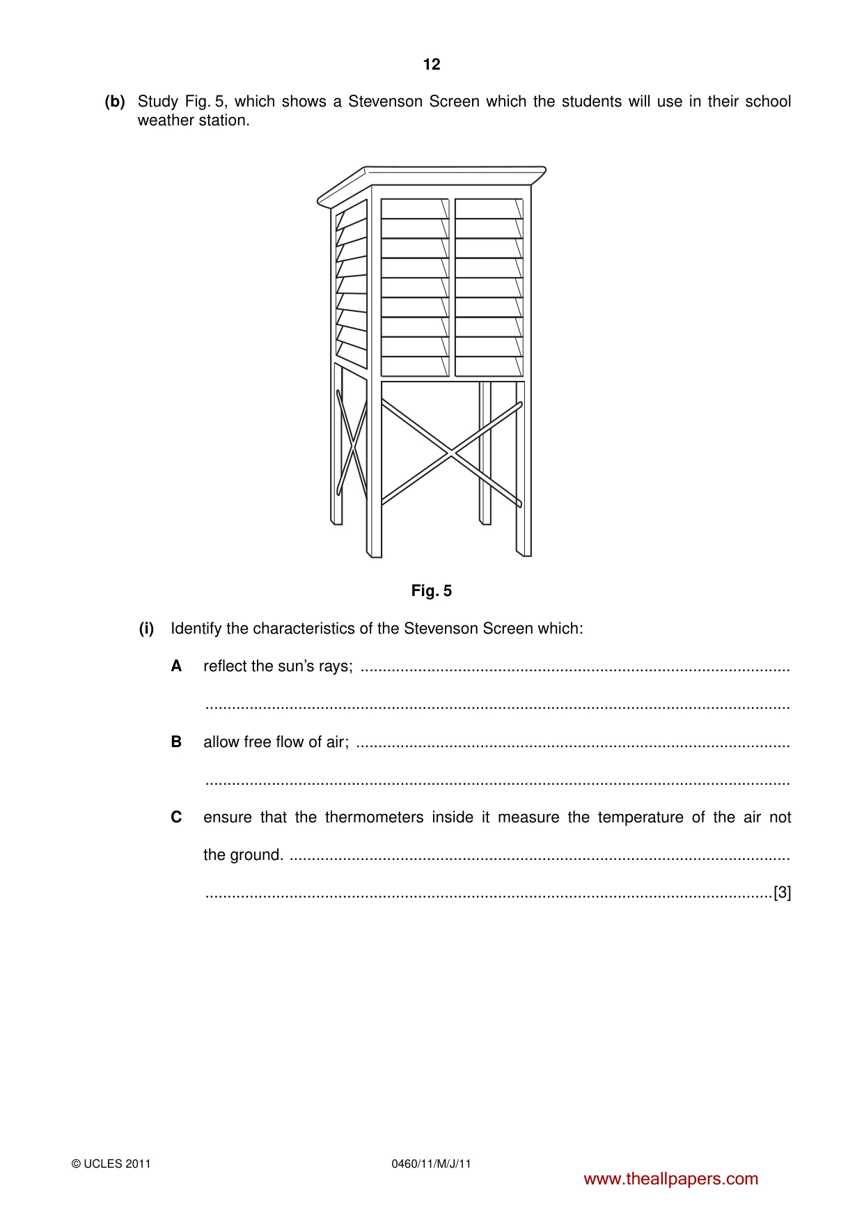
12 0460/11/M/J/11 © UCLES 2011 (b) Study Fig. 5, which shows a Stevenson Screen which the students will use in their school weather station. Fig. 5 (i) Identify the characteristics of the Stevenson Screen which: A reflect the sun’s rays; … … B allow free flow of air; … … C ensure that the thermometers inside it measure the temperature of the air not the ground. … …[3] www.theallpapers.com
Question paper, page 13
13 0460/11/M/J/11 © UCLES 2011 [Turn over (ii) What advice would you give the students about where to site the Stevenson Screen? Give reasons for your answer. … … … … … … … … …[5] (c) Name an area which you have studied where tropical storms occur. Describe the problems which they cause for people living in your chosen area. Name of area … … … … … … … … … … … … … … …[7] [Total: 25 marks] END OF QUESTION 3 www.theallpapers.com
Question paper, page 14
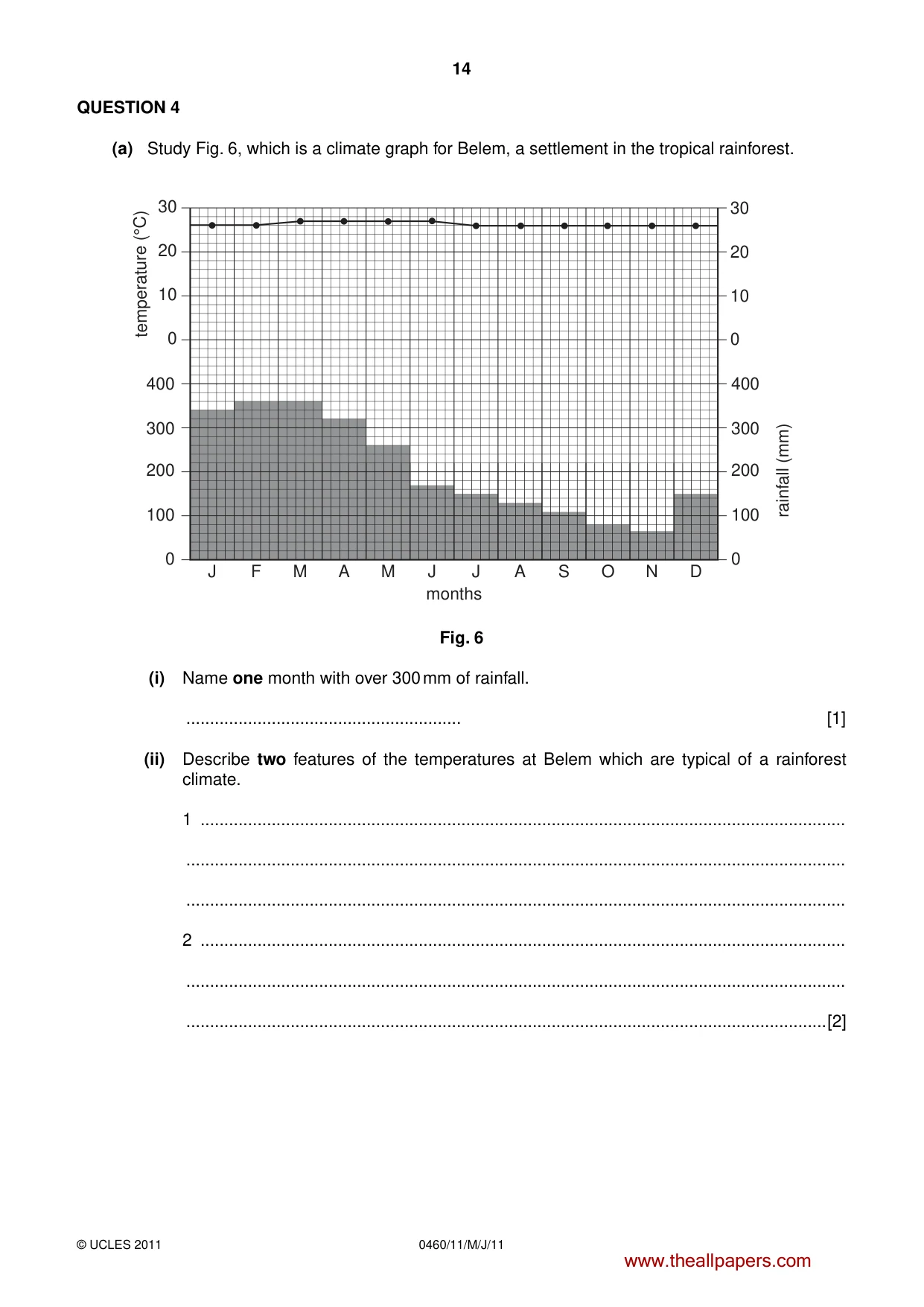
14 0460/11/M/J/11 © UCLES 2011 QUESTION 4 (a) Study Fig. 6, which is a climate graph for Belem, a settlement in the tropical rainforest. 0 10 20 30 10 0 20 30 200 300 400 100 0 200 300 400 100 0 J F M A M J J A S O N D months temperature (°C) rainfall (mm) Fig. 6 (i) Name one month with over 300 mm of rainfall. … [1] (ii) Describe two features of the temperatures at Belem which are typical of a rainforest climate. 1 … … … 2 … … …[2] www.theallpapers.com
Question paper, page 15
15 0460/11/M/J/11 © UCLES 2011 [Turn over (iii) Explain why the climate of places like Belem results in the growth of rainforests. … … … … … … … … …[3] (iv) Describe the characteristics of the natural vegetation in a tropical rainforest. … … … … … … … … … …[4] www.theallpapers.com
Question paper, page 16
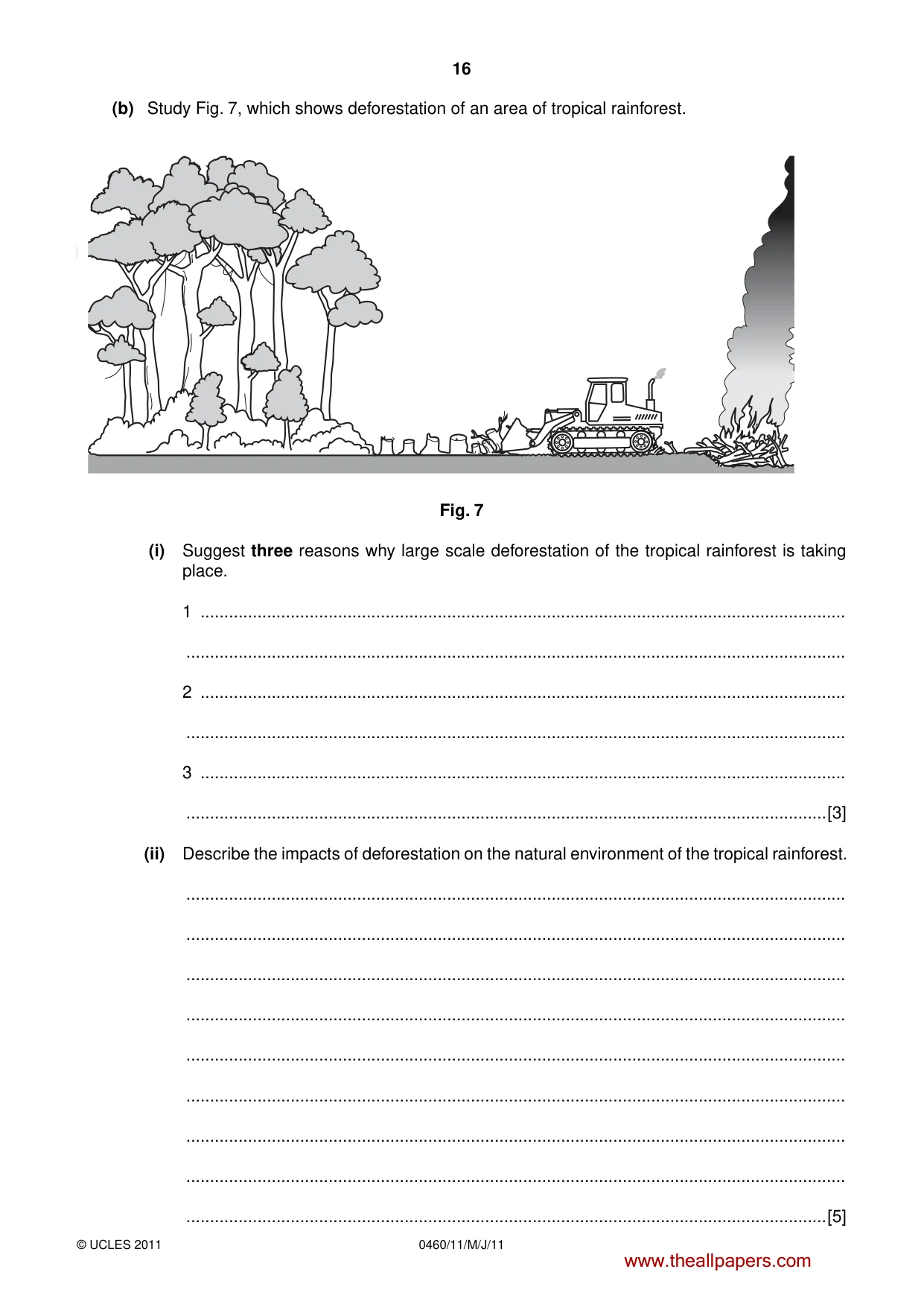
16 0460/11/M/J/11 © UCLES 2011 (b) Study Fig. 7, which shows deforestation of an area of tropical rainforest. Fig. 7 (i) Suggest three reasons why large scale deforestation of the tropical rainforest is taking place. 1 … … 2 … … 3 … …[3] (ii) Describe the impacts of deforestation on the natural environment of the tropical rainforest. … … … … … … … … …[5] www.theallpapers.com
Question paper, page 17
17 0460/11/M/J/11 © UCLES 2011 [Turn over (c) For a named area of tropical desert which you have studied, describe and explain the characteristics of its climate. Area of tropical desert … … … … … … … … … … … … … … …[7] [Total: 25 marks] END OF QUESTION 4 www.theallpapers.com
Question paper, page 18
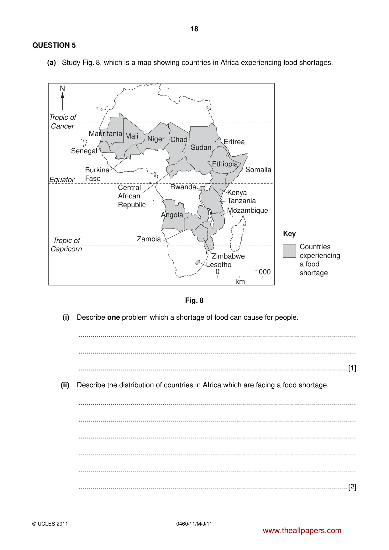
18 0460/11/M/J/11 © UCLES 2011 QUESTION 5 (a) Study Fig. 8, which is a map showing countries in Africa experiencing food shortages. Tropic of Cancer Tropic of Capricorn Equator Countries experiencing a food shortage 0 1000 Senegal Burkina Faso Central African Republic Rwanda Zambia Angola Lesotho Zimbabwe Mozambique Tanzania Kenya Somalia Eritrea Ethiopia Sudan Chad Niger Mali Mauritania N km Key Fig. 8 (i) Describe one problem which a shortage of food can cause for people. … … …[1] (ii) Describe the distribution of countries in Africa which are facing a food shortage. … … … … … …[2] www.theallpapers.com
Question paper, page 19
19 0460/11/M/J/11 © UCLES 2011 [Turn over (iii) Give three different natural events which could cause food shortages. 1 … … 2 … … 3 … …[3] (iv) Explain why a poor harvest of food crops is likely to have a greater impact on an LEDC in Africa than an MEDC in Europe. … … … … … … … … … …[4] www.theallpapers.com
Question paper, page 20
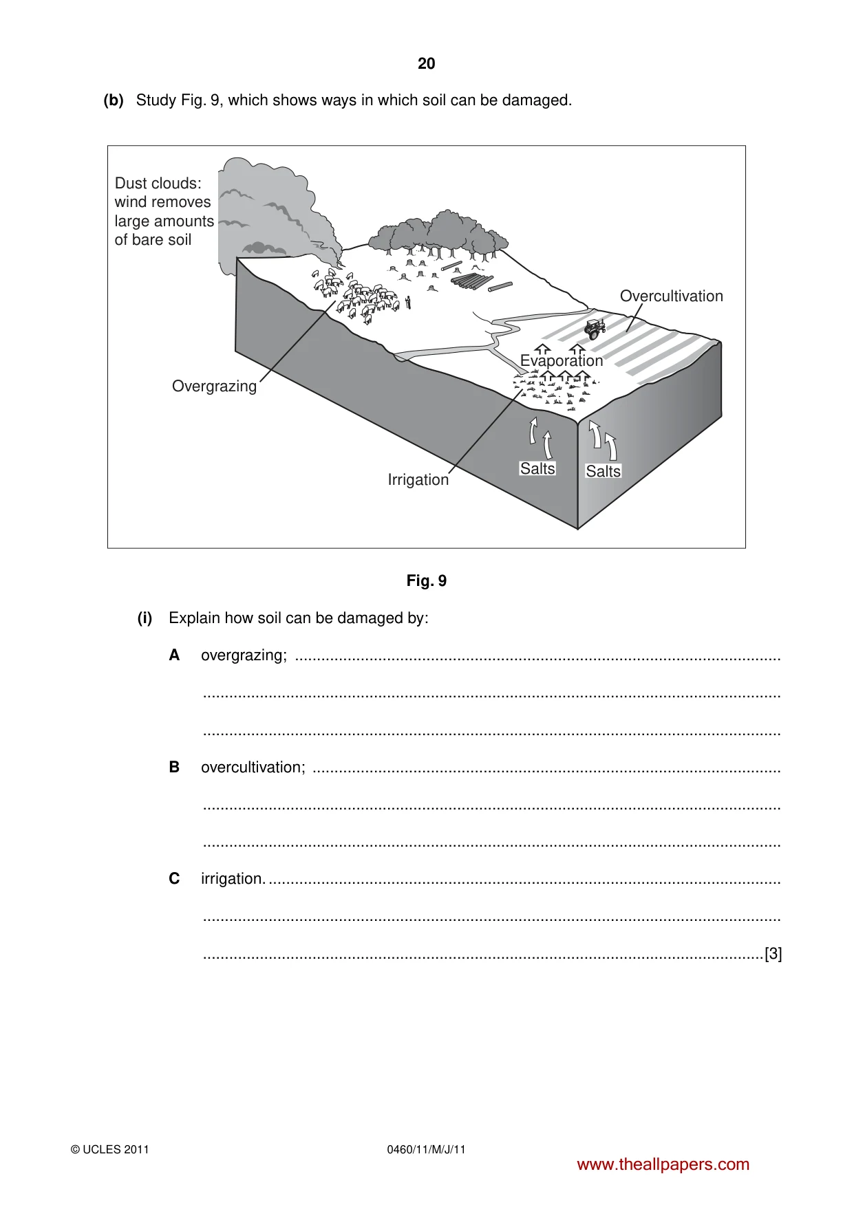
20 0460/11/M/J/11 © UCLES 2011 (b) Study Fig. 9, which shows ways in which soil can be damaged. Overgrazing Irrigation Overcultivation Salts Evaporation Salts Dust clouds: wind removes large amounts of bare soil Fig. 9 (i) Explain how soil can be damaged by: A overgrazing; … … … B overcultivation; … … … C irrigation. … … …[3] www.theallpapers.com
Question paper, page 21
21 0460/11/M/J/11 © UCLES 2011 [Turn over (ii) Explain how the quality of the soil can be maintained and soil erosion reduced. … … … … … … … … …[5] (c) Name an area where large-scale commercial farming takes place. Describe the inputs, processes and outputs of this farming system. Name of area … … … … … … … … … … … … … …[7] [Total: 25 marks] END OF QUESTION 5 www.theallpapers.com
Question paper, page 22
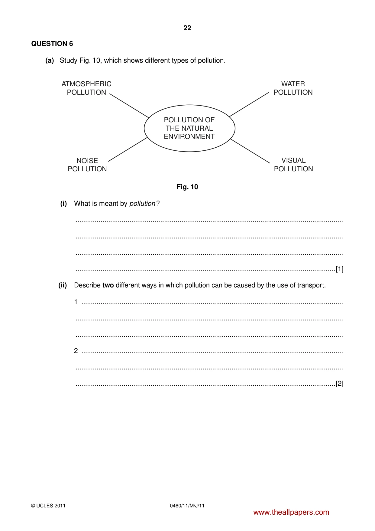
22 0460/11/M/J/11 © UCLES 2011 QUESTION 6 (a) Study Fig. 10, which shows different types of pollution. ATMOSPHERIC POLLUTION WATER POLLUTION NOISE POLLUTION VISUAL POLLUTION POLLUTION OF THE NATURAL ENVIRONMENT Fig. 10 (i) What is meant by pollution ? … … … …[1] (ii) Describe two different ways in which pollution can be caused by the use of transport. 1 … … … 2 … … …[2] www.theallpapers.com
Question paper, page 23
23 0460/11/M/J/11 © UCLES 2011 [Turn over (iii) Explain why, in many countries, industrial waste is released into rivers, lakes and seas. … … … … … … … …[3] (iv) Give one global problem which can be caused by atmospheric pollution. Explain how atmospheric pollution can cause this problem. Name of problem … … … … … … … … …[4] www.theallpapers.com
Question paper, page 24
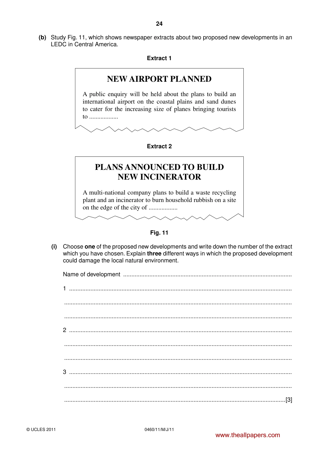
24 0460/11/M/J/11 © UCLES 2011 (b) Study Fig. 11, which shows newspaper extracts about two proposed new developments in an LEDC in Central America. Extract 1 NEW AIRPORT PLANNED A public enquiry will be held about the plans to build an international airport on the coastal plains and sand dunes to cater for the increasing size of planes bringing tourists to … Extract 2 PLANS ANNOUNCED TO BUILD NEW INCINERATOR A multi-national company plans to build a waste recycling plant and an incinerator to burn household rubbish on a site on the edge of the city of … Fig. 11 (i) Choose one of the proposed new developments and write down the number of the extract which you have chosen. Explain three different ways in which the proposed development could damage the local natural environment. Name of development … 1 … … … 2 … … … 3 … … …[3] www.theallpapers.com
Question paper, page 25
25 0460/11/M/J/11 © UCLES 2011 (ii) Suggest what could be done to ensure that your chosen development is sustainable. … … … … … … … … …[5] (c) For a named country or area which you have studied, describe the ways in which energy supplies are being developed. Name of country or area … … … … … … … … … … … … … … …[7] [Total: 25 marks] END OF QUESTION 6 www.theallpapers.com
Question paper, page 26
26 0460/11/M/J/11 © UCLES 2011 Additional Page If you use the following lined page to complete the answer(s) to any question(s), the question number(s) must be clearly shown. … … … … … … … … … … … … … … … … … … … … … … … … … … www.theallpapers.com
Question paper, page 27
27 0460/11/M/J/11 © UCLES 2011 BLANK PAGE www.theallpapers.com
Question paper, page 28
28 0460/11/M/J/11 © UCLES 2011 Copyright Acknowledgements: Question 1 Photographs A and B Steve Sibley © UCLES. Permission to reproduce items where third-party owned material protected by copyright is included has been sought and cleared where possible. Every reasonable effort has been made by the publisher (UCLES) to trace copyright holders, but if any items requiring clearance have unwittingly been included, the publisher will be pleased to make amends at the earliest possible opportunity. University of Cambridge International Examinations is part of the Cambridge Assessment Group. Cambridge Assessment is the brand name of University of Cambridge Local Examinations Syndicate (UCLES), which is itself a department of the University of Cambridge. BLANK PAGE www.theallpapers.com
Mark scheme, page 1
UNIVERSITY OF CAMBRIDGE INTERNATIONAL EXAMINATIONS International General Certificate of Secondary Education MARK SCHEME for the May/June 2011 question paper for the guidance of teachers 0460 GEOGRAPHY 0460/11 Paper 1, maximum raw mark 75 This mark scheme is published as an aid to teachers and candidates, to indicate the requirements of the examination. It shows the basis on which Examiners were instructed to award marks. It does not indicate the details of the discussions that took place at an Examiners’ meeting before marking began, which would have considered the acceptability of alternative answers. Mark schemes must be read in conjunction with the question papers and the report on the examination. • Cambridge will not enter into discussions or correspondence in connection with these mark schemes. Cambridge is publishing the mark schemes for the May/June 2011 question papers for most IGCSE, GCE Advanced Level and Advanced Subsidiary Level syllabuses and some Ordinary Level syllabuses. www.theallpapers.com
Mark scheme, page 2
Page 2 Mark Scheme: Teachers’ version Syllabus Paper IGCSE – May/June 2011 0460 11 © University of Cambridge International Examinations 2011 1 (a) (i) An area where many people live in a small area/per square kilometre/over 50 people per square kilometre; 1 mark [1] (ii) A. Europe, France, NE USA/Eastern USA, Japan, England, Wales, Northern Ireland, California etc. B. Indonesia, Eastern China, Japan, India, Singapore, Thailand, Philippines etc. 2 @ 1 mark [2] (iii) A. Ideas such as: e.g. Area X it is an area of desert/there are inadequate water supplies; food cannot be grown/crops can’t be grown; many parts are isolated/poor communications/inaccessible/no roads; there are few resources; there is little employment/no jobs; etc. e.g. Area Y temperatures are low/very cold for much of year/long winters/short summers; food cannot be grown/crops can’t be grown; difficult to get to/remote/inaccessible/seas are frozen for several months; there are few resources; there is little employment/no jobs; snow/ice covered; etc. 3 @ 1 mark [3] (b) (i) Ideas such as: flood plain/it might flood; marshy land/swampy; people do not want their homes/settlements/crops flooded; land likely to be used for rice/irrigated/farmland; 3 @ 1 mark [3] (ii) Ideas such as: relief is high/steep/mountainous/hilly/hills/no flat land; it is difficult to build homes/settlement/expensive to build; roads will be hard to construct/difficult to get to/inaccessible; low temperatures; high precipitation/wet; windy; mud/land slides; would need to build terraces to grow crops; etc. 4 @ 1 mark [4] www.theallpapers.com
Mark scheme, page 3
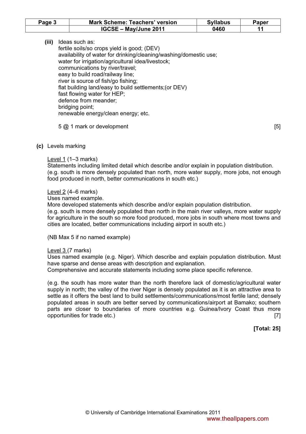
Page 3 Mark Scheme: Teachers’ version Syllabus Paper IGCSE – May/June 2011 0460 11 © University of Cambridge International Examinations 2011 (iii) Ideas such as: fertile soils/so crops yield is good; (DEV) availability of water for drinking/cleaning/washing/domestic use; water for irrigation/agricultural idea/livestock; communications by river/travel; easy to build road/railway line; river is source of fish/go fishing; flat building land/easy to build settlements;(or DEV) fast flowing water for HEP; defence from meander; bridging point; renewable energy/clean energy; etc. 5 @ 1 mark or development [5] (c) Levels marking Level 1 (1–3 marks) Statements including limited detail which describe and/or explain in population distribution. (e.g. south is more densely populated than north, more water supply, more jobs, not enough food produced in north, better communications in south etc.) Level 2 (4–6 marks) Uses named example. More developed statements which describe and/or explain population distribution. (e.g. south is more densely populated than north in the main river valleys, more water supply for agriculture in the south so more food produced, more jobs in south where most towns and cities are located, better communications including airport in south etc.) (NB Max 5 if no named example) Level 3 (7 marks) Uses named example (e.g. Niger). Which describe and explain population distribution. Must have sparse and dense areas with description and explanation. Comprehensive and accurate statements including some place specific reference. (e.g. the south has more water than the north therefore lack of domestic/agricultural water supply in north; the valley of the river Niger is densely populated as it is an attractive area to settle as it offers the best land to build settlements/communications/most fertile land; densely populated areas in south are better served by communications/airport at Bamako; southern parts are closer to boundaries of more countries e.g. Guinea/Ivory Coast thus more opportunities for trade etc.) [7] [Total: 25] www.theallpapers.com
Mark scheme, page 4
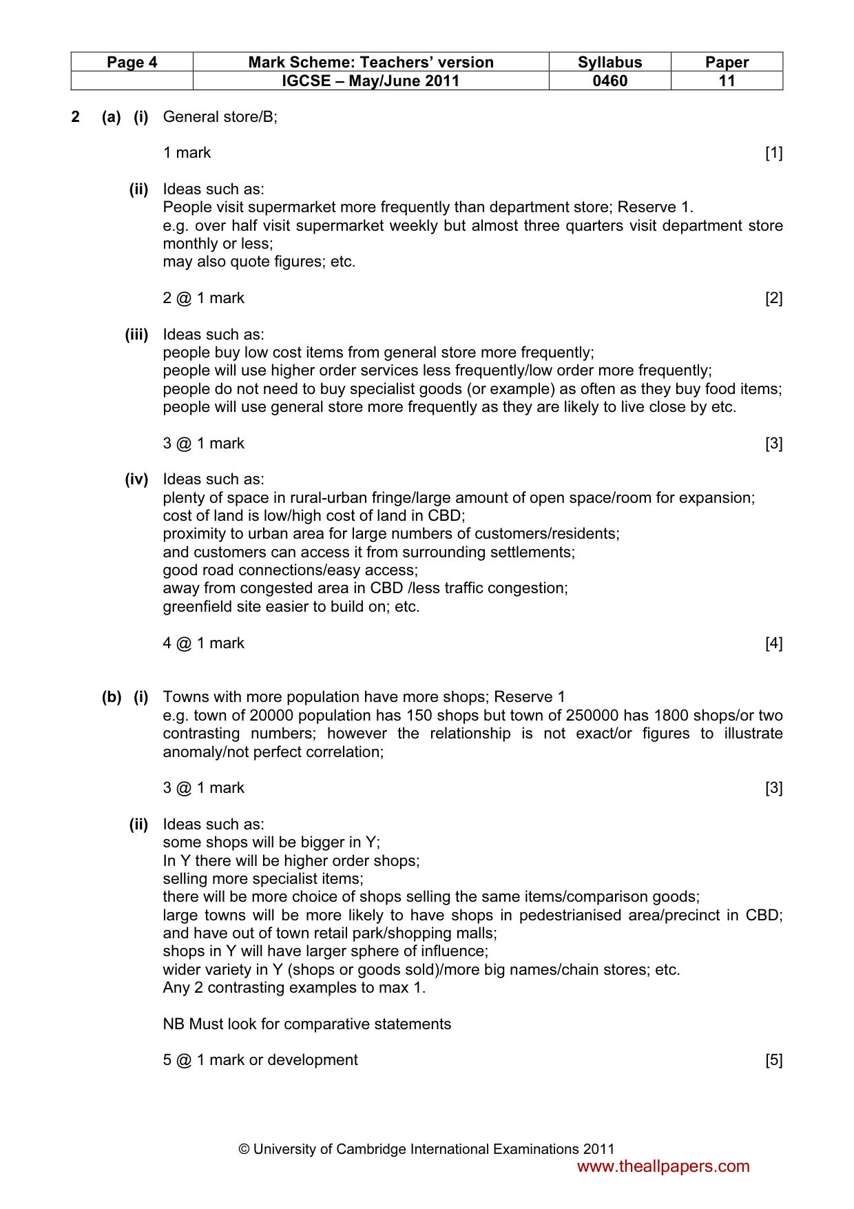
Page 4 Mark Scheme: Teachers’ version Syllabus Paper IGCSE – May/June 2011 0460 11 © University of Cambridge International Examinations 2011 2 (a) (i) General store/B; 1 mark [1] (ii) Ideas such as: People visit supermarket more frequently than department store; Reserve 1. e.g. over half visit supermarket weekly but almost three quarters visit department store monthly or less; may also quote figures; etc. 2 @ 1 mark [2] (iii) Ideas such as: people buy low cost items from general store more frequently; people will use higher order services less frequently/low order more frequently; people do not need to buy specialist goods (or example) as often as they buy food items; people will use general store more frequently as they are likely to live close by etc. 3 @ 1 mark [3] (iv) Ideas such as: plenty of space in rural-urban fringe/large amount of open space/room for expansion; cost of land is low/high cost of land in CBD; proximity to urban area for large numbers of customers/residents; and customers can access it from surrounding settlements; good road connections/easy access; away from congested area in CBD /less traffic congestion; greenfield site easier to build on; etc. 4 @ 1 mark [4] (b) (i) Towns with more population have more shops; Reserve 1 e.g. town of 20000 population has 150 shops but town of 250000 has 1800 shops/or two contrasting numbers; however the relationship is not exact/or figures to illustrate anomaly/not perfect correlation; 3 @ 1 mark [3] (ii) Ideas such as: some shops will be bigger in Y; In Y there will be higher order shops; selling more specialist items; there will be more choice of shops selling the same items/comparison goods; large towns will be more likely to have shops in pedestrianised area/precinct in CBD; and have out of town retail park/shopping malls; shops in Y will have larger sphere of influence; wider variety in Y (shops or goods sold)/more big names/chain stores; etc. Any 2 contrasting examples to max 1. NB Must look for comparative statements 5 @ 1 mark or development [5] www.theallpapers.com
Mark scheme, page 5
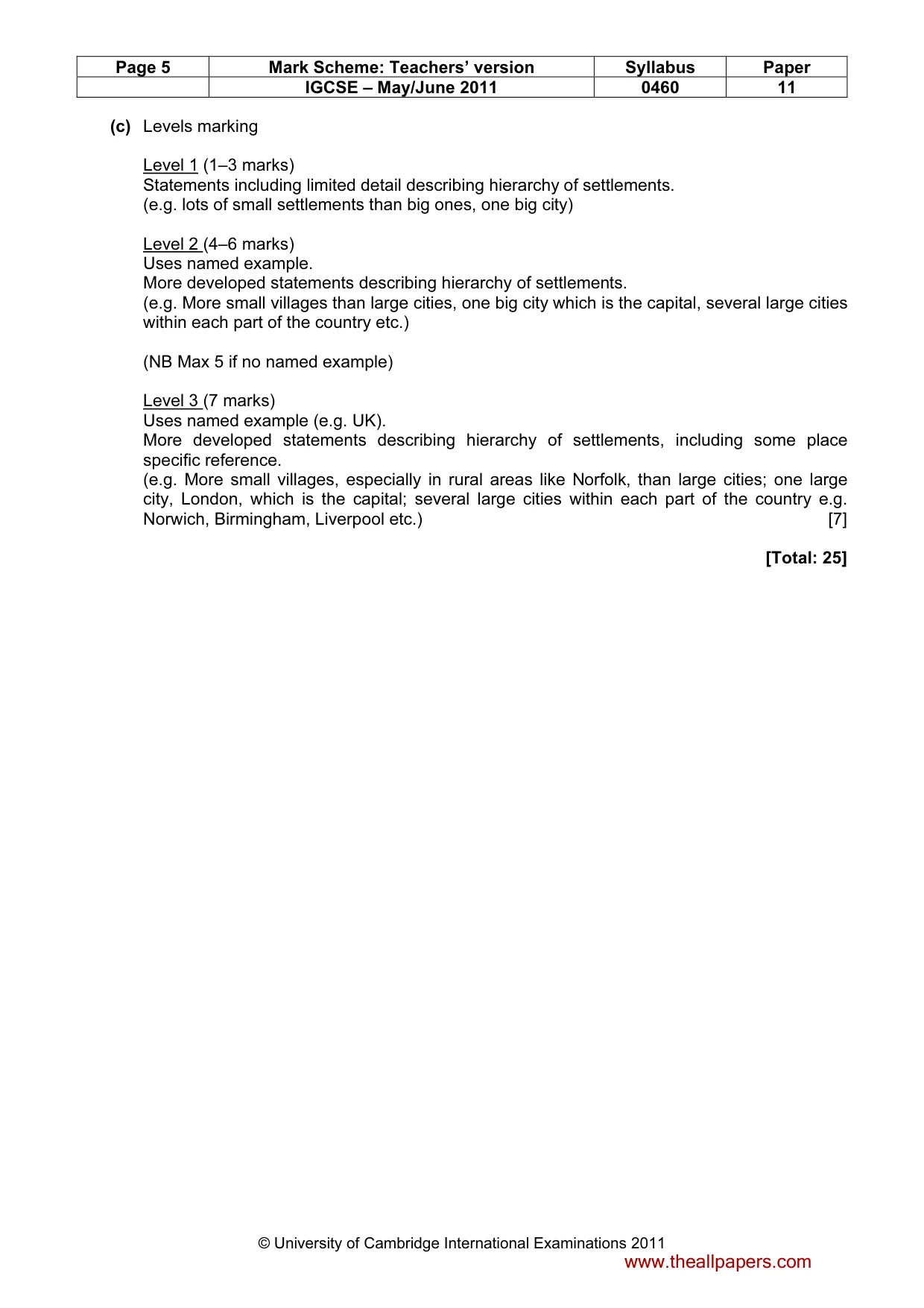
Page 5 Mark Scheme: Teachers’ version Syllabus Paper IGCSE – May/June 2011 0460 11 © University of Cambridge International Examinations 2011 (c) Levels marking Level 1 (1–3 marks) Statements including limited detail describing hierarchy of settlements. (e.g. lots of small settlements than big ones, one big city) Level 2 (4–6 marks) Uses named example. More developed statements describing hierarchy of settlements. (e.g. More small villages than large cities, one big city which is the capital, several large cities within each part of the country etc.) (NB Max 5 if no named example) Level 3 (7 marks) Uses named example (e.g. UK). More developed statements describing hierarchy of settlements, including some place specific reference. (e.g. More small villages, especially in rural areas like Norfolk, than large cities; one large city, London, which is the capital; several large cities within each part of the country e.g. Norwich, Birmingham, Liverpool etc.) [7] [Total: 25] www.theallpapers.com
Mark scheme, page 6
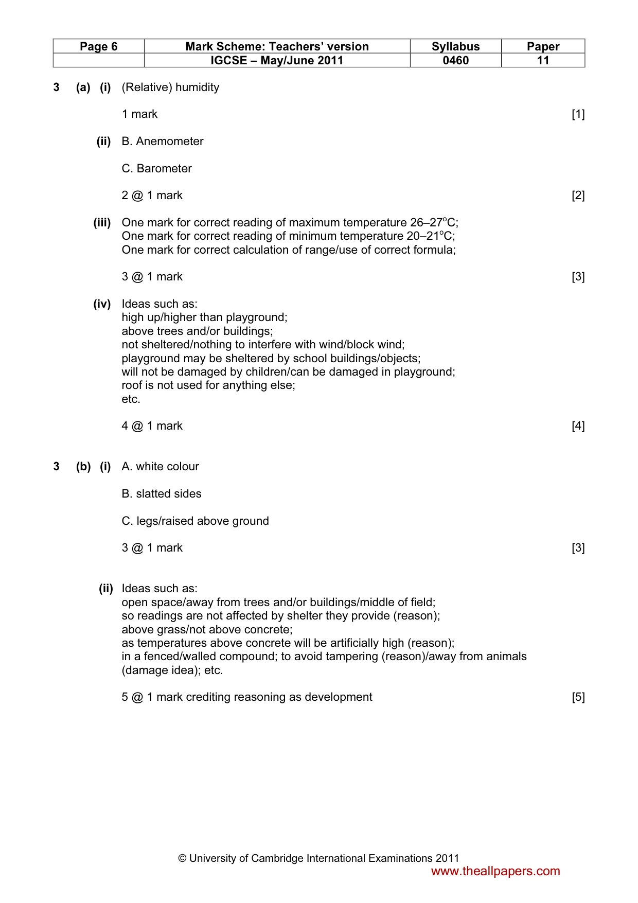
Page 6 Mark Scheme: Teachers’ version Syllabus Paper IGCSE – May/June 2011 0460 11 © University of Cambridge International Examinations 2011 3 (a) (i) (Relative) humidity 1 mark [1] (ii) B. Anemometer C. Barometer 2 @ 1 mark [2] (iii) One mark for correct reading of maximum temperature 26–27oC; One mark for correct reading of minimum temperature 20–21oC; One mark for correct calculation of range/use of correct formula; 3 @ 1 mark [3] (iv) Ideas such as: high up/higher than playground; above trees and/or buildings; not sheltered/nothing to interfere with wind/block wind; playground may be sheltered by school buildings/objects; will not be damaged by children/can be damaged in playground; roof is not used for anything else; etc. 4 @ 1 mark [4] 3 (b) (i) A. white colour B. slatted sides C. legs/raised above ground 3 @ 1 mark [3] (ii) Ideas such as: open space/away from trees and/or buildings/middle of field; so readings are not affected by shelter they provide (reason); above grass/not above concrete; as temperatures above concrete will be artificially high (reason); in a fenced/walled compound; to avoid tampering (reason)/away from animals (damage idea); etc. 5 @ 1 mark crediting reasoning as development [5] www.theallpapers.com
Mark scheme, page 7
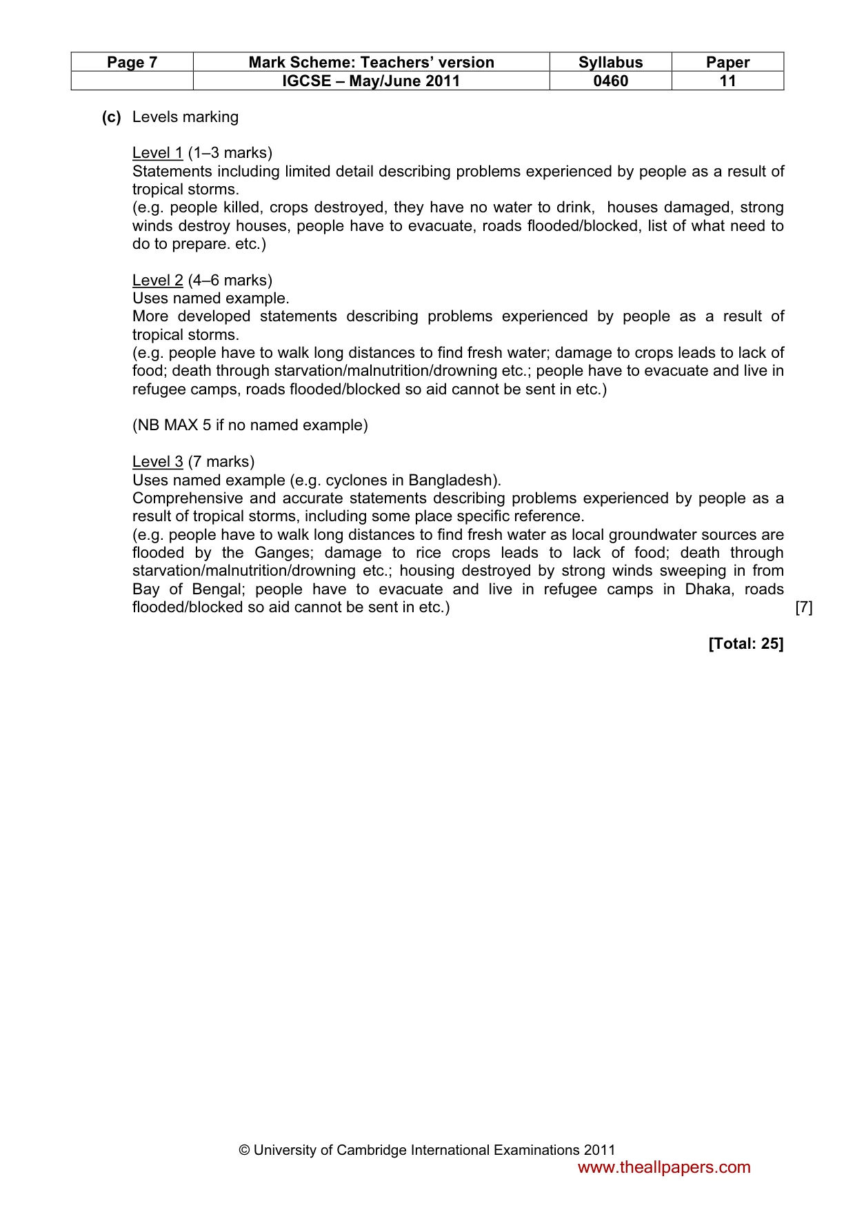
Page 7 Mark Scheme: Teachers’ version Syllabus Paper IGCSE – May/June 2011 0460 11 © University of Cambridge International Examinations 2011 (c) Levels marking Level 1 (1–3 marks) Statements including limited detail describing problems experienced by people as a result of tropical storms. (e.g. people killed, crops destroyed, they have no water to drink, houses damaged, strong winds destroy houses, people have to evacuate, roads flooded/blocked, list of what need to do to prepare. etc.) Level 2 (4–6 marks) Uses named example. More developed statements describing problems experienced by people as a result of tropical storms. (e.g. people have to walk long distances to find fresh water; damage to crops leads to lack of food; death through starvation/malnutrition/drowning etc.; people have to evacuate and live in refugee camps, roads flooded/blocked so aid cannot be sent in etc.) (NB MAX 5 if no named example) Level 3 (7 marks) Uses named example (e.g. cyclones in Bangladesh). Comprehensive and accurate statements describing problems experienced by people as a result of tropical storms, including some place specific reference. (e.g. people have to walk long distances to find fresh water as local groundwater sources are flooded by the Ganges; damage to rice crops leads to lack of food; death through starvation/malnutrition/drowning etc.; housing destroyed by strong winds sweeping in from Bay of Bengal; people have to evacuate and live in refugee camps in Dhaka, roads flooded/blocked so aid cannot be sent in etc.) [7] [Total: 25] www.theallpapers.com
Mark scheme, page 8
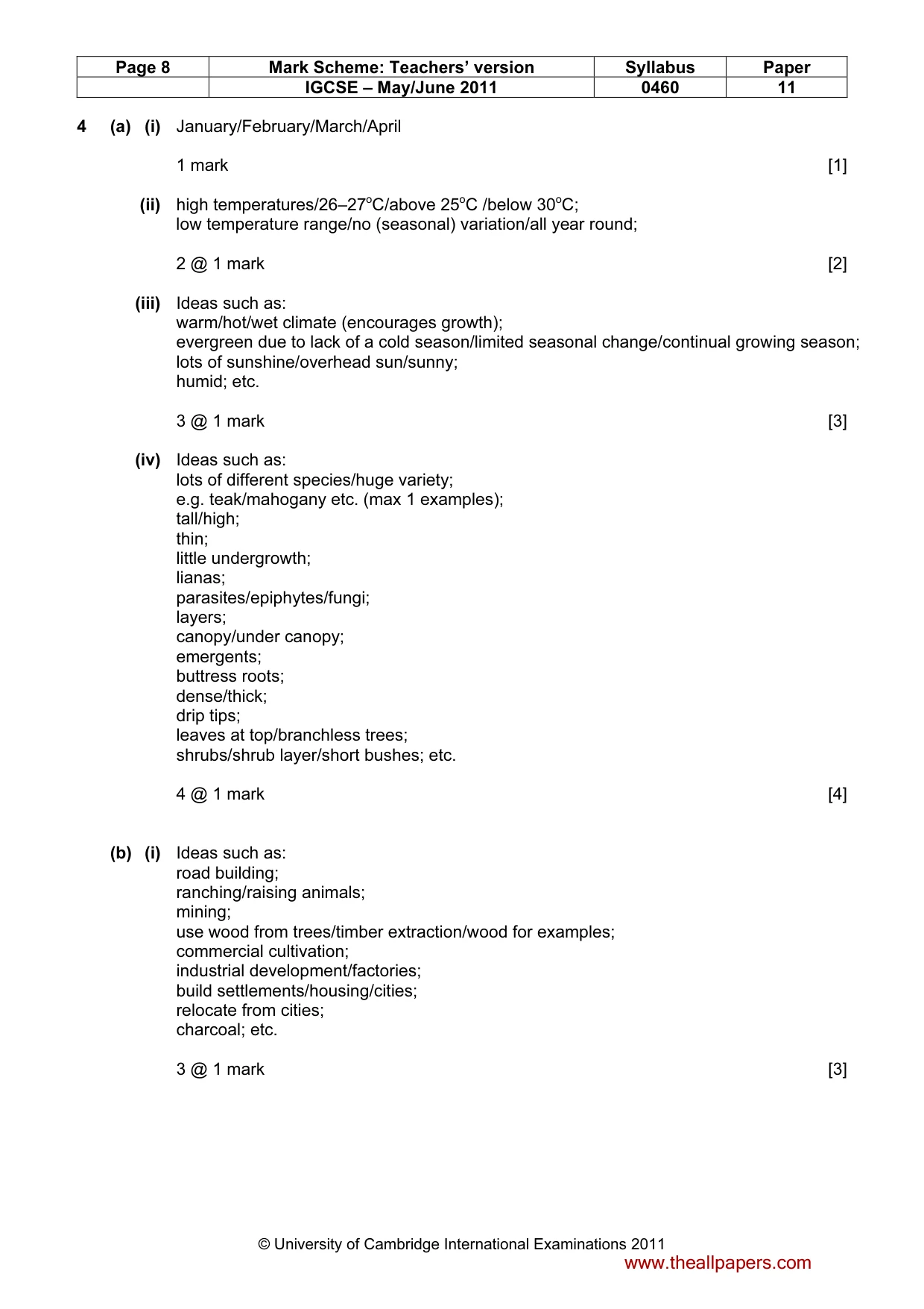
Page 8 Mark Scheme: Teachers’ version Syllabus Paper IGCSE – May/June 2011 0460 11 © University of Cambridge International Examinations 2011 4 (a) (i) January/February/March/April 1 mark [1] (ii) high temperatures/26–27oC/above 25oC /below 30oC; low temperature range/no (seasonal) variation/all year round; 2 @ 1 mark [2] (iii) Ideas such as: warm/hot/wet climate (encourages growth); evergreen due to lack of a cold season/limited seasonal change/continual growing season; lots of sunshine/overhead sun/sunny; humid; etc. 3 @ 1 mark [3] (iv) Ideas such as: lots of different species/huge variety; e.g. teak/mahogany etc. (max 1 examples); tall/high; thin; little undergrowth; lianas; parasites/epiphytes/fungi; layers; canopy/under canopy; emergents; buttress roots; dense/thick; drip tips; leaves at top/branchless trees; shrubs/shrub layer/short bushes; etc. 4 @ 1 mark [4] (b) (i) Ideas such as: road building; ranching/raising animals; mining; use wood from trees/timber extraction/wood for examples; commercial cultivation; industrial development/factories; build settlements/housing/cities; relocate from cities; charcoal; etc. 3 @ 1 mark [3] www.theallpapers.com
Mark scheme, page 9
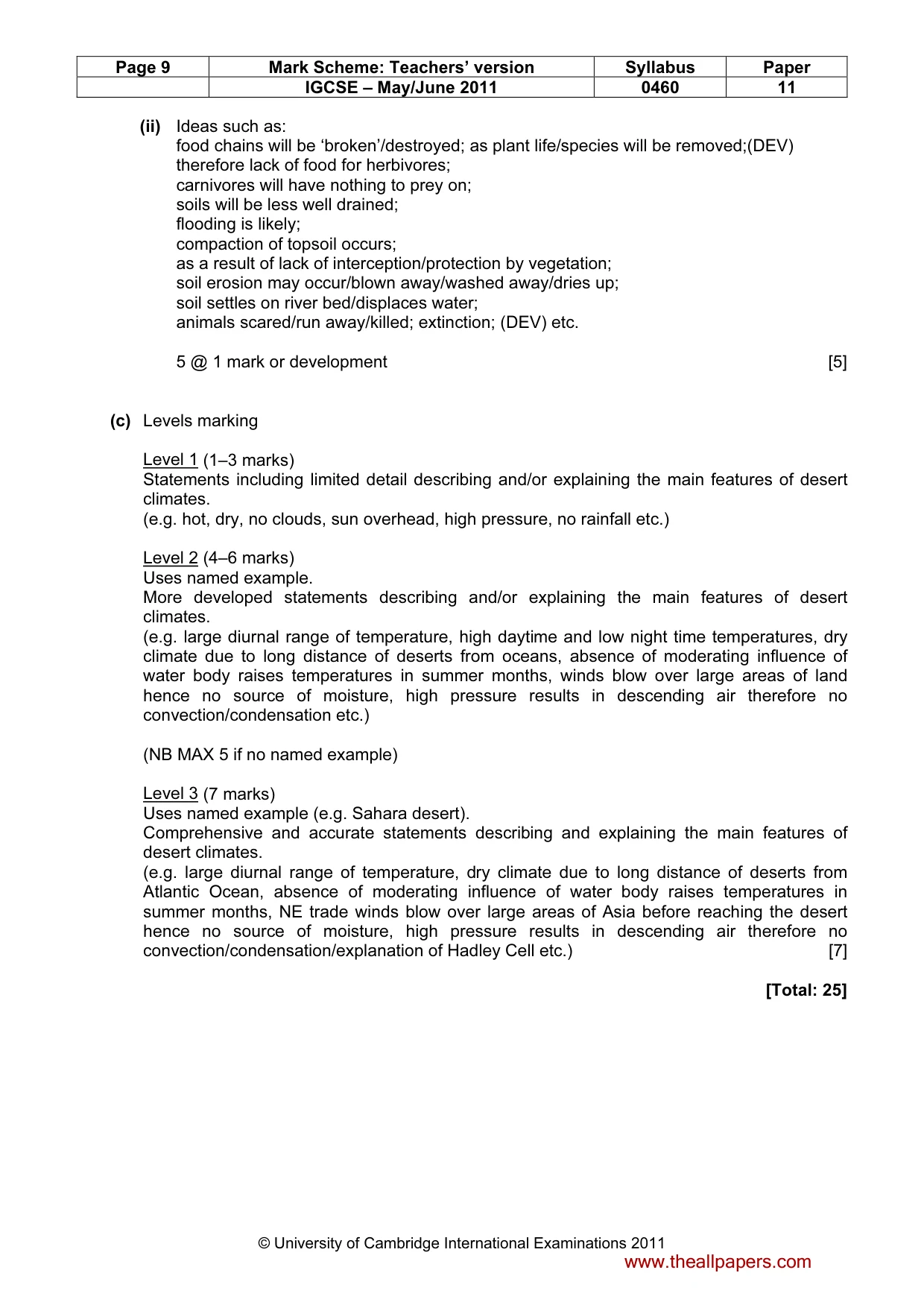
Page 9 Mark Scheme: Teachers’ version Syllabus Paper IGCSE – May/June 2011 0460 11 © University of Cambridge International Examinations 2011 (ii) Ideas such as: food chains will be ‘broken’/destroyed; as plant life/species will be removed;(DEV) therefore lack of food for herbivores; carnivores will have nothing to prey on; soils will be less well drained; flooding is likely; compaction of topsoil occurs; as a result of lack of interception/protection by vegetation; soil erosion may occur/blown away/washed away/dries up; soil settles on river bed/displaces water; animals scared/run away/killed; extinction; (DEV) etc. 5 @ 1 mark or development [5] (c) Levels marking Level 1 (1–3 marks) Statements including limited detail describing and/or explaining the main features of desert climates. (e.g. hot, dry, no clouds, sun overhead, high pressure, no rainfall etc.) Level 2 (4–6 marks) Uses named example. More developed statements describing and/or explaining the main features of desert climates. (e.g. large diurnal range of temperature, high daytime and low night time temperatures, dry climate due to long distance of deserts from oceans, absence of moderating influence of water body raises temperatures in summer months, winds blow over large areas of land hence no source of moisture, high pressure results in descending air therefore no convection/condensation etc.) (NB MAX 5 if no named example) Level 3 (7 marks) Uses named example (e.g. Sahara desert). Comprehensive and accurate statements describing and explaining the main features of desert climates. (e.g. large diurnal range of temperature, dry climate due to long distance of deserts from Atlantic Ocean, absence of moderating influence of water body raises temperatures in summer months, NE trade winds blow over large areas of Asia before reaching the desert hence no source of moisture, high pressure results in descending air therefore no convection/condensation/explanation of Hadley Cell etc.) [7] [Total: 25] www.theallpapers.com
Mark scheme, page 10
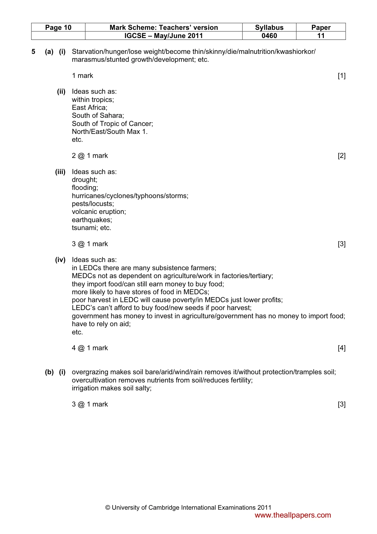
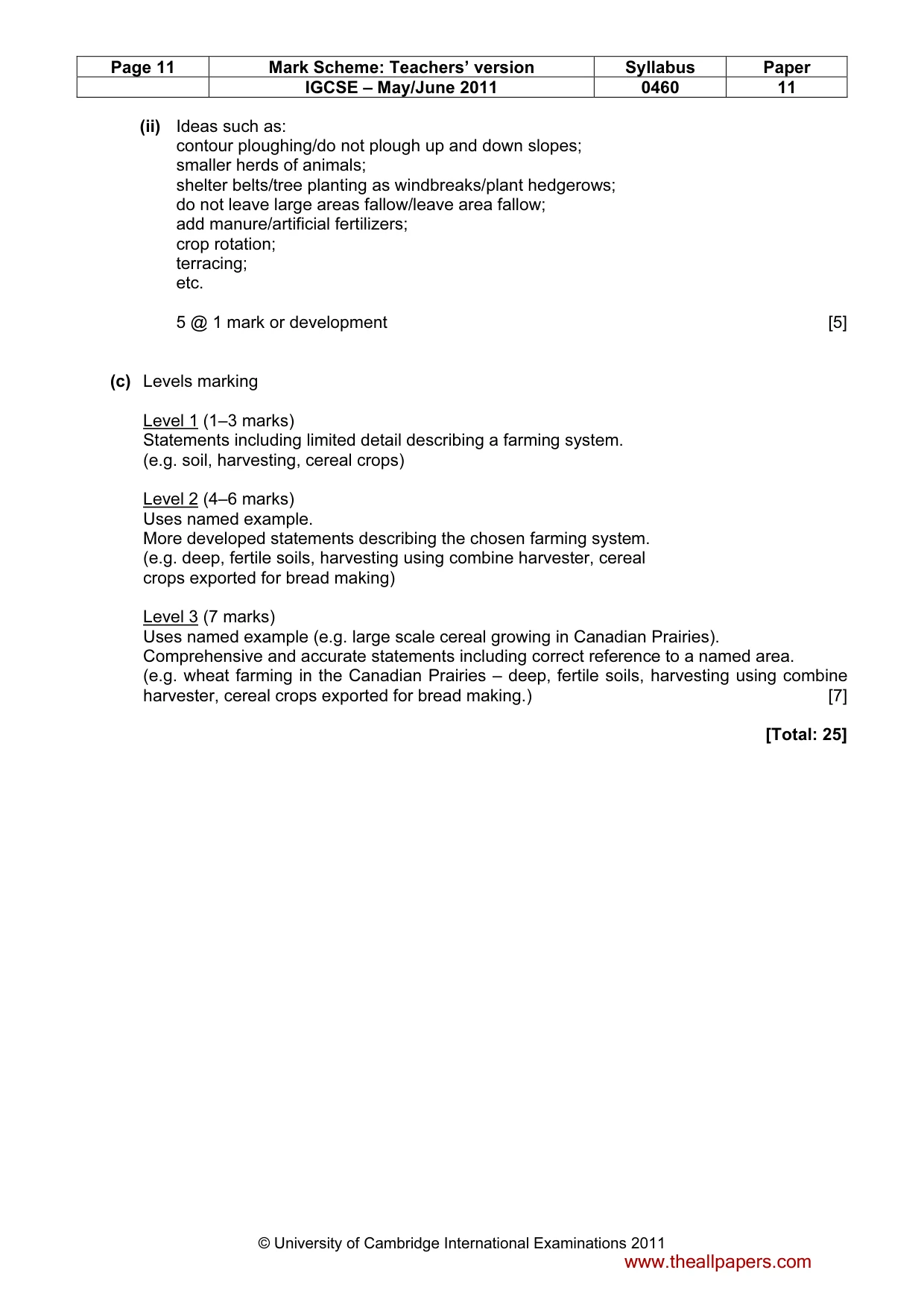
Page 10 Mark Scheme: Teachers’ version Syllabus Paper IGCSE – May/June 2011 0460 11 © University of Cambridge International Examinations 2011 5 (a) (i) Starvation/hunger/lose weight/become thin/skinny/die/malnutrition/kwashiorkor/ marasmus/stunted growth/development; etc. 1 mark [1] (ii) Ideas such as: within tropics; East Africa; South of Sahara; South of Tropic of Cancer; North/East/South Max 1. etc. 2 @ 1 mark [2] (iii) Ideas such as: drought; flooding; hurricanes/cyclones/typhoons/storms; pests/locusts; volcanic eruption; earthquakes; tsunami; etc. 3 @ 1 mark [3] (iv) Ideas such as: in LEDCs there are many subsistence farmers; MEDCs not as dependent on agriculture/work in factories/tertiary; they import food/can still earn money to buy food; more likely to have stores of food in MEDCs; poor harvest in LEDC will cause poverty/in MEDCs just lower profits; LEDC’s can’t afford to buy food/new seeds if poor harvest; government has money to invest in agriculture/government has no money to import food; have to rely on aid; etc. 4 @ 1 mark [4] (b) (i) overgrazing makes soil bare/arid/wind/rain removes it/without protection/tramples soil; overcultivation removes nutrients from soil/reduces fertility; irrigation makes soil salty; 3 @ 1 mark [3] www.theallpapers.com
Mark scheme, page 11
Page 11 Mark Scheme: Teachers’ version Syllabus Paper IGCSE – May/June 2011 0460 11 © University of Cambridge International Examinations 2011 (ii) Ideas such as: contour ploughing/do not plough up and down slopes; smaller herds of animals; shelter belts/tree planting as windbreaks/plant hedgerows; do not leave large areas fallow/leave area fallow; add manure/artificial fertilizers; crop rotation; terracing; etc. 5 @ 1 mark or development [5] (c) Levels marking Level 1 (1–3 marks) Statements including limited detail describing a farming system. (e.g. soil, harvesting, cereal crops) Level 2 (4–6 marks) Uses named example. More developed statements describing the chosen farming system. (e.g. deep, fertile soils, harvesting using combine harvester, cereal crops exported for bread making) Level 3 (7 marks) Uses named example (e.g. large scale cereal growing in Canadian Prairies). Comprehensive and accurate statements including correct reference to a named area. (e.g. wheat farming in the Canadian Prairies – deep, fertile soils, harvesting using combine harvester, cereal crops exported for bread making.) [7] [Total: 25] www.theallpapers.com
Mark scheme, page 12
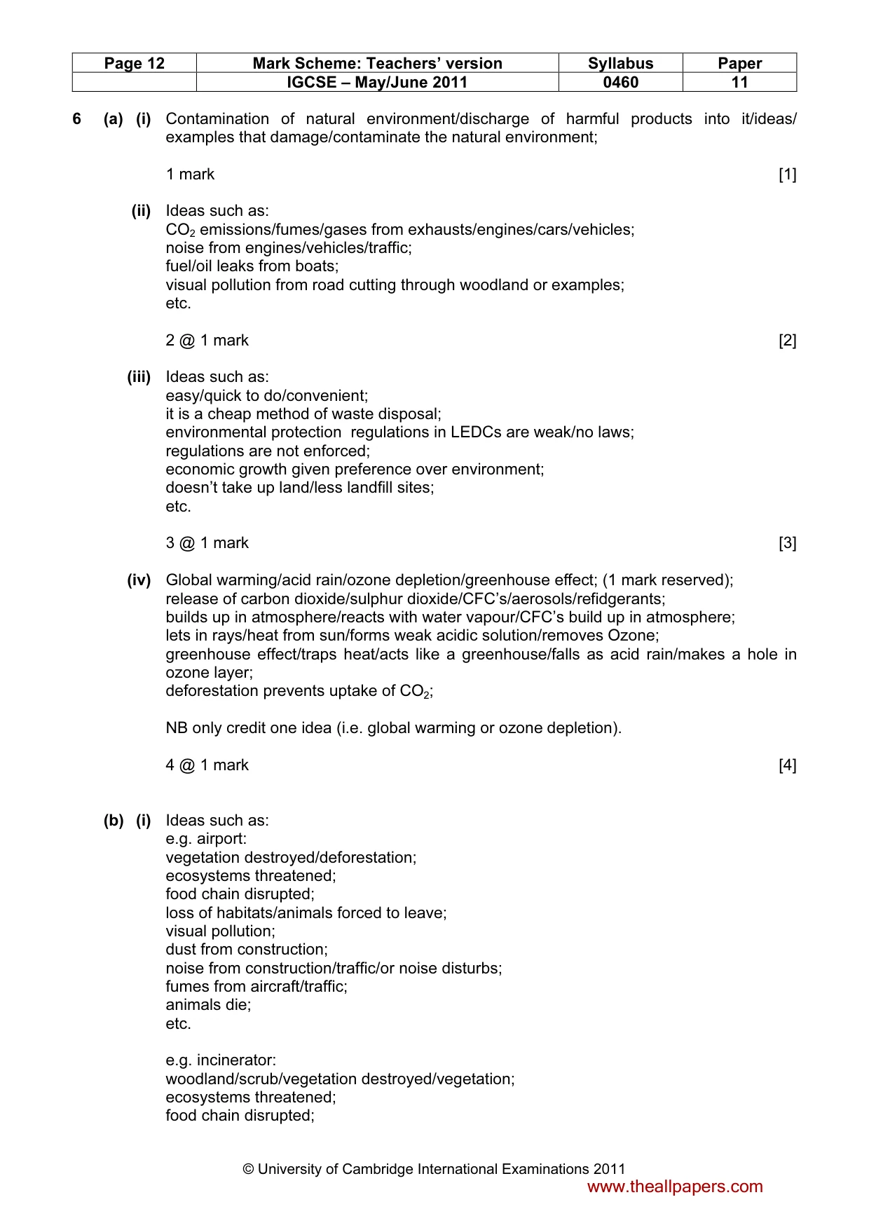
Page 12 Mark Scheme: Teachers’ version Syllabus Paper IGCSE – May/June 2011 0460 11 © University of Cambridge International Examinations 2011 6 (a) (i) Contamination of natural environment/discharge of harmful products into it/ideas/ examples that damage/contaminate the natural environment; 1 mark [1] (ii) Ideas such as: CO2 emissions/fumes/gases from exhausts/engines/cars/vehicles; noise from engines/vehicles/traffic; fuel/oil leaks from boats; visual pollution from road cutting through woodland or examples; etc. 2 @ 1 mark [2] (iii) Ideas such as: easy/quick to do/convenient; it is a cheap method of waste disposal; environmental protection regulations in LEDCs are weak/no laws; regulations are not enforced; economic growth given preference over environment; doesn’t take up land/less landfill sites; etc. 3 @ 1 mark [3] (iv) Global warming/acid rain/ozone depletion/greenhouse effect; (1 mark reserved); release of carbon dioxide/sulphur dioxide/CFC’s/aerosols/refidgerants; builds up in atmosphere/reacts with water vapour/CFC’s build up in atmosphere; lets in rays/heat from sun/forms weak acidic solution/removes Ozone; greenhouse effect/traps heat/acts like a greenhouse/falls as acid rain/makes a hole in ozone layer; deforestation prevents uptake of CO2; NB only credit one idea (i.e. global warming or ozone depletion). 4 @ 1 mark [4] (b) (i) Ideas such as: e.g. airport: vegetation destroyed/deforestation; ecosystems threatened; food chain disrupted; loss of habitats/animals forced to leave; visual pollution; dust from construction; noise from construction/traffic/or noise disturbs; fumes from aircraft/traffic; animals die; etc. e.g. incinerator: woodland/scrub/vegetation destroyed/vegetation; ecosystems threatened; food chain disrupted; www.theallpapers.com
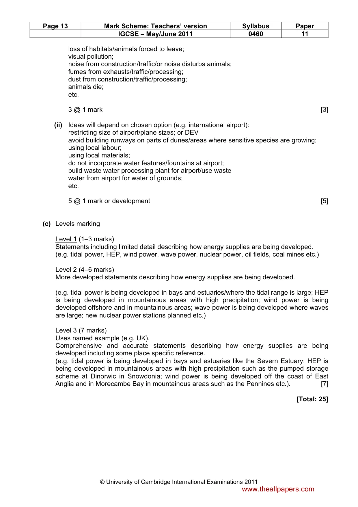
Mark scheme, page 13
Page 13 Mark Scheme: Teachers’ version Syllabus Paper IGCSE – May/June 2011 0460 11 © University of Cambridge International Examinations 2011 loss of habitats/animals forced to leave; visual pollution; noise from construction/traffic/or noise disturbs animals; fumes from exhausts/traffic/processing; dust from construction/traffic/processing; animals die; etc. 3 @ 1 mark [3] (ii) Ideas will depend on chosen option (e.g. international airport): restricting size of airport/plane sizes; or DEV avoid building runways on parts of dunes/areas where sensitive species are growing; using local labour; using local materials; do not incorporate water features/fountains at airport; build waste water processing plant for airport/use waste water from airport for water of grounds; etc. 5 @ 1 mark or development [5] (c) Levels marking Level 1 (1–3 marks) Statements including limited detail describing how energy supplies are being developed. (e.g. tidal power, HEP, wind power, wave power, nuclear power, oil fields, coal mines etc.) Level 2 (4–6 marks) More developed statements describing how energy supplies are being developed. (e.g. tidal power is being developed in bays and estuaries/where the tidal range is large; HEP is being developed in mountainous areas with high precipitation; wind power is being developed offshore and in mountainous areas; wave power is being developed where waves are large; new nuclear power stations planned etc.) Level 3 (7 marks) Uses named example (e.g. UK). Comprehensive and accurate statements describing how energy supplies are being developed including some place specific reference. (e.g. tidal power is being developed in bays and estuaries like the Severn Estuary; HEP is being developed in mountainous areas with high precipitation such as the pumped storage scheme at Dinorwic in Snowdonia; wind power is being developed off the coast of East Anglia and in Morecambe Bay in mountainous areas such as the Pennines etc.). [7] [Total: 25] www.theallpapers.com
What you needed in this session
Cambridge’s own grade thresholds for 2011 May/June, Paper 1 · Variant 1. A higher threshold means an easier paper — the bar moves with how the cohort did.