Cambridge IGCSE Geography 0460 — 2006 May/June Paper 2 · Variant 1
0460/21/M/J/06 · 60 marks · ≈68 min
The question paper and its mark scheme, free to read here and free to download. This is Cambridge’s own paper, exactly as it was sat.
Question paper16 pages

Mark scheme4 pages
Answers below. Sit the paper first if you are practising.
Paper as text
Question paper, page 1
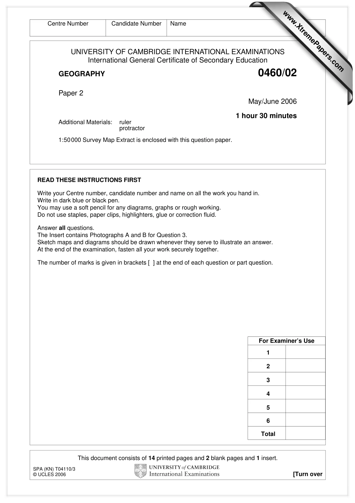
This document consists of 14 printed pages and 2 blank pages and 1 insert. SPA (KN) T04110/3 © UCLES 2006 [Turn over UNIVERSITY OF CAMBRIDGE INTERNATIONAL EXAMINATIONS International General Certificate of Secondary Education GEOGRAPHY 0460/02 Paper 2 May/June 2006 1 hour 30 minutes Additional Materials: ruler protractor 1:50000 Survey Map Extract is enclosed with this question paper. READ THESE INSTRUCTIONS FIRST Write your Centre number, candidate number and name on all the work you hand in. Write in dark blue or black pen. You may use a soft pencil for any diagrams, graphs or rough working. Do not use staples, paper clips, highlighters, glue or correction fluid. Answer all questions. The Insert contains Photographs A and B for Question 3. Sketch maps and diagrams should be drawn whenever they serve to illustrate an answer. At the end of the examination, fasten all your work securely together. The number of marks is given in brackets [ ] at the end of each question or part question. Centre Number Candidate Number Name For Examiner’s Use 1 2 3 4 5 6 Total www.XtremePapers.com
Question paper, page 2
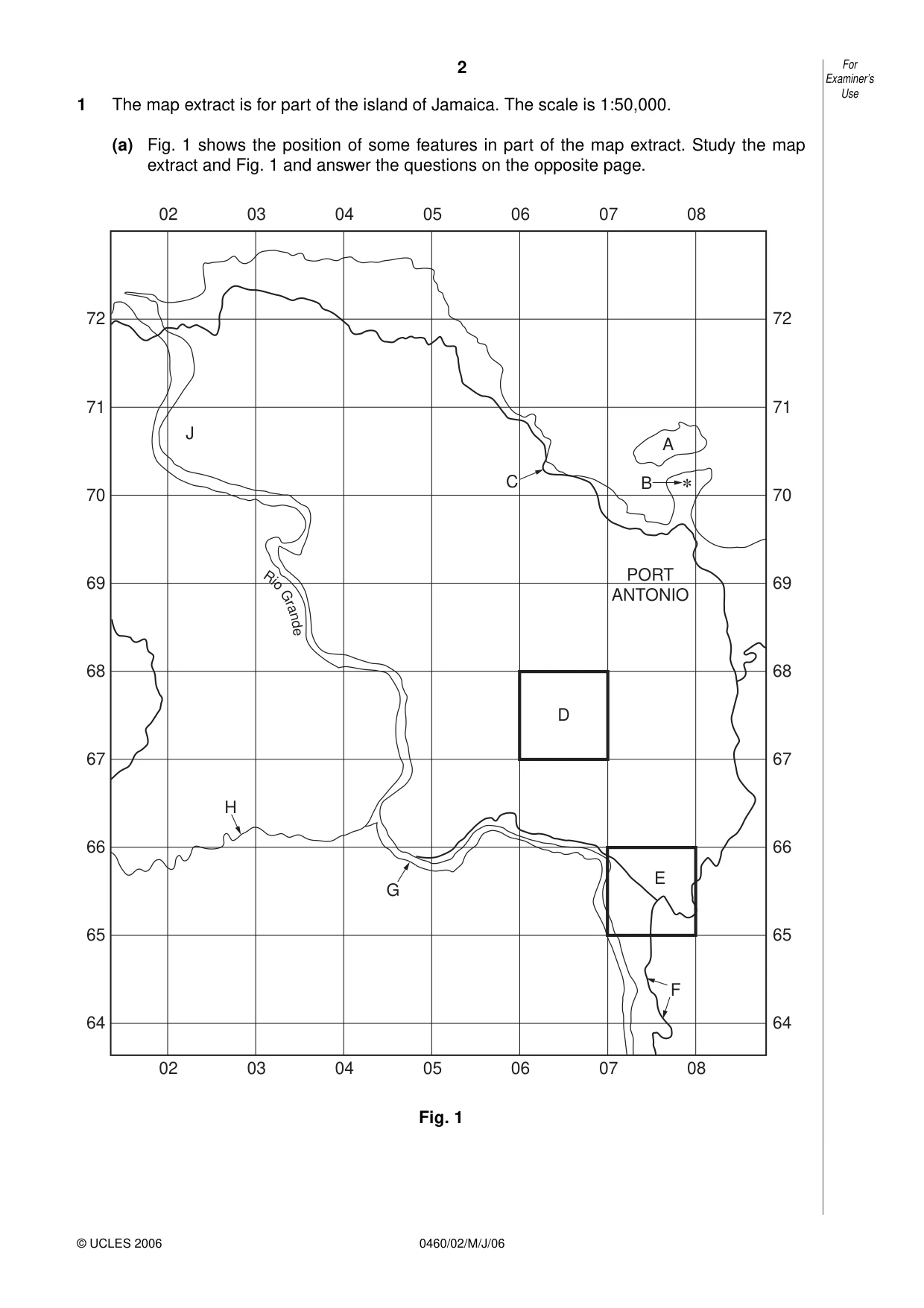
2 0460/02/M/J/06 1 The map extract is for part of the island of Jamaica. The scale is 1:50,000. (a) Fig. 1 shows the position of some features in part of the map extract. Study the map extract and Fig. 1 and answer the questions on the opposite page. Fig. 1 72 71 70 69 68 67 66 65 64 72 71 70 69 68 67 66 65 64 02 03 04 05 06 07 08 02 03 04 05 06 07 08 R i o G r a n d e F H G E D PORT ANTONIO C 8 B A J For Examiner’s Use © UCLES 2006
Question paper, page 3
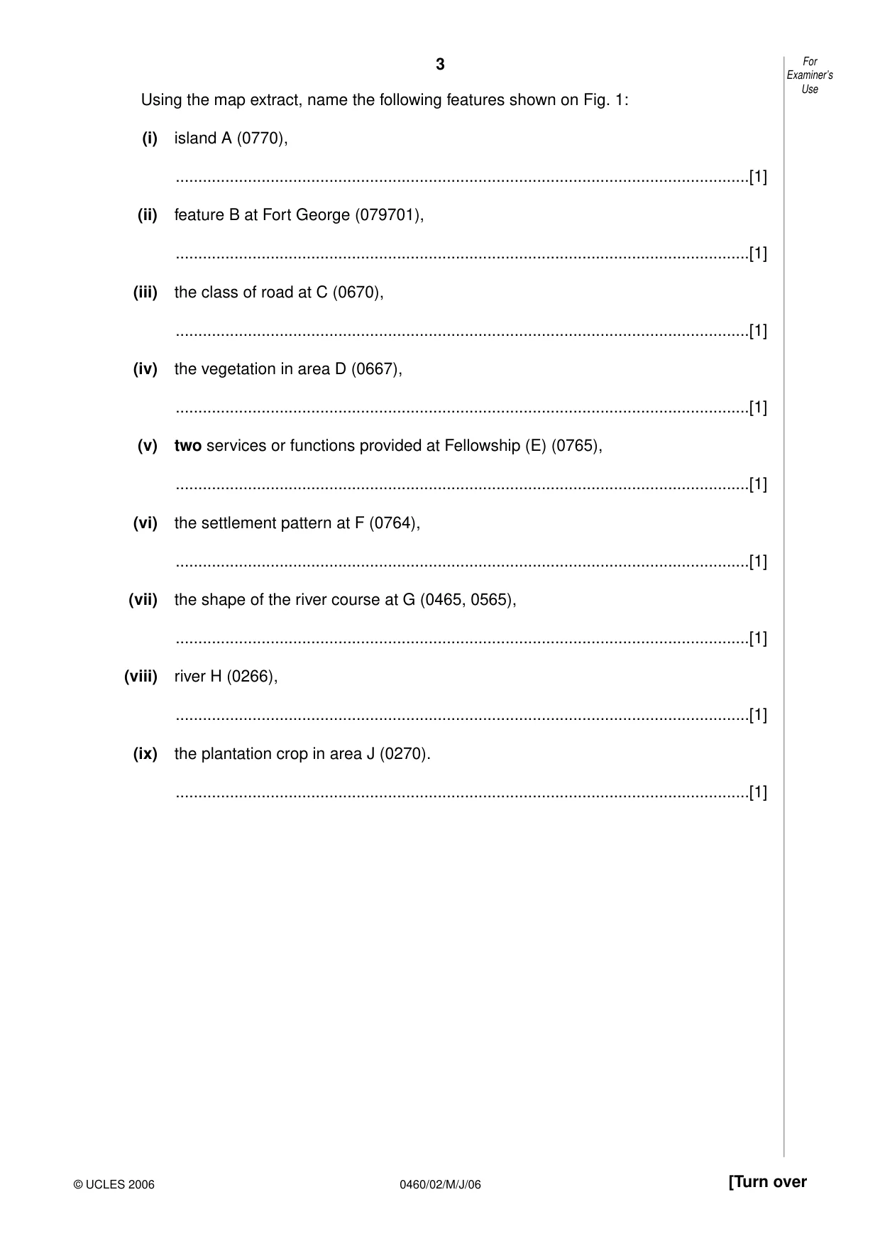
3 0460/02/M/J/06 [Turn over Using the map extract, name the following features shown on Fig. 1: (i) island A (0770), …[1] (ii) feature B at Fort George (079701), …[1] (iii) the class of road at C (0670), …[1] (iv) the vegetation in area D (0667), …[1] (v) two services or functions provided at Fellowship (E) (0765), …[1] (vi) the settlement pattern at F (0764), …[1] (vii) the shape of the river course at G (0465, 0565), …[1] (viii) river H (0266), …[1] (ix) the plantation crop in area J (0270). …[1] For Examiner’s Use © UCLES 2006
Question paper, page 4
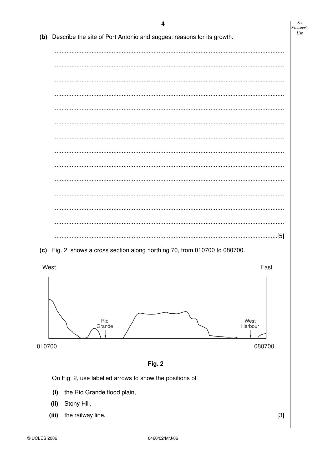
4 0460/02/M/J/06 (b) Describe the site of Port Antonio and suggest reasons for its growth. … … … … … … … … … … … … … …[5] (c) Fig. 2 shows a cross section along northing 70, from 010700 to 080700. Fig. 2 On Fig. 2, use labelled arrows to show the positions of (i) the Rio Grande flood plain, (ii) Stony Hill, (iii) the railway line. [3] 010700 080700 West East West Harbour Rio Grande For Examiner’s Use © UCLES 2006
Question paper, page 5
5 0460/02/M/J/06 [Turn over (d) (i) A boat travels from Folly Point (088707) to Ship Head (050726). In which compass direction does the boat travel? …[1] (ii) State the six figure grid reference for Ship Rock on the north coast. …[1] (iii) Measure the distance along the railway from Snow Hill Halt (030725) to Norwich Halt (056712). Give your answer in metres. …metres [1] For Examiner’s Use © UCLES 2006
Question paper, page 6
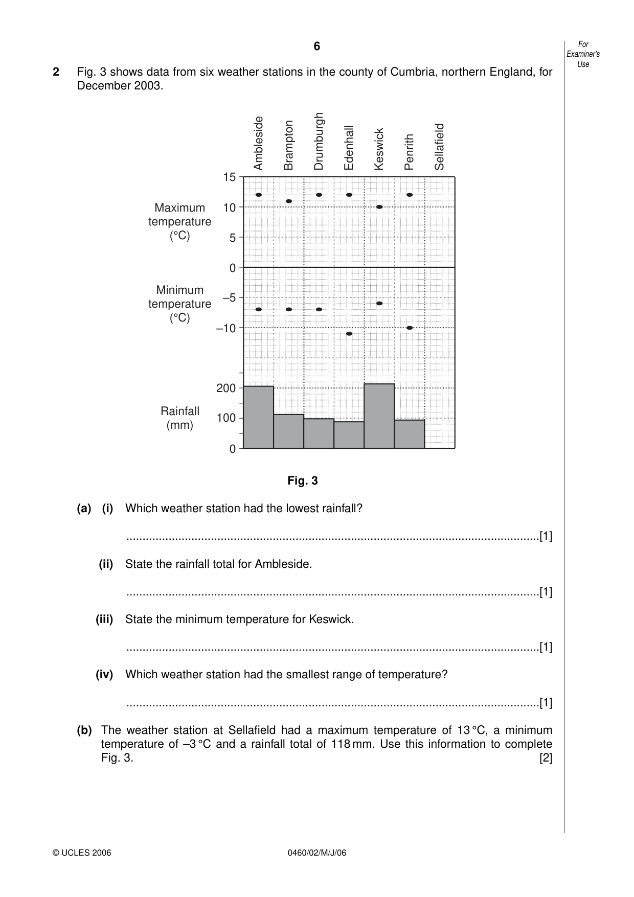
6 0460/02/M/J/06 2 Fig. 3 shows data from six weather stations in the county of Cumbria, northern England, for December 2003. Fig. 3 (a) (i) Which weather station had the lowest rainfall? …[1] (ii) State the rainfall total for Ambleside. …[1] (iii) State the minimum temperature for Keswick. …[1] (iv) Which weather station had the smallest range of temperature? …[1] (b) The weather station at Sellafield had a maximum temperature of 13 °C, a minimum temperature of –3 °C and a rainfall total of 118 mm. Use this information to complete Fig. 3. [2] 0 100 200 –10 –5 0 5 10 15 Rainfall (mm) Maximum temperature (°C) Minimum temperature (°C) Ambleside Brampton Drumburgh Edenhall Keswick Penrith Sellafield For Examiner’s Use © UCLES 2006
Question paper, page 7
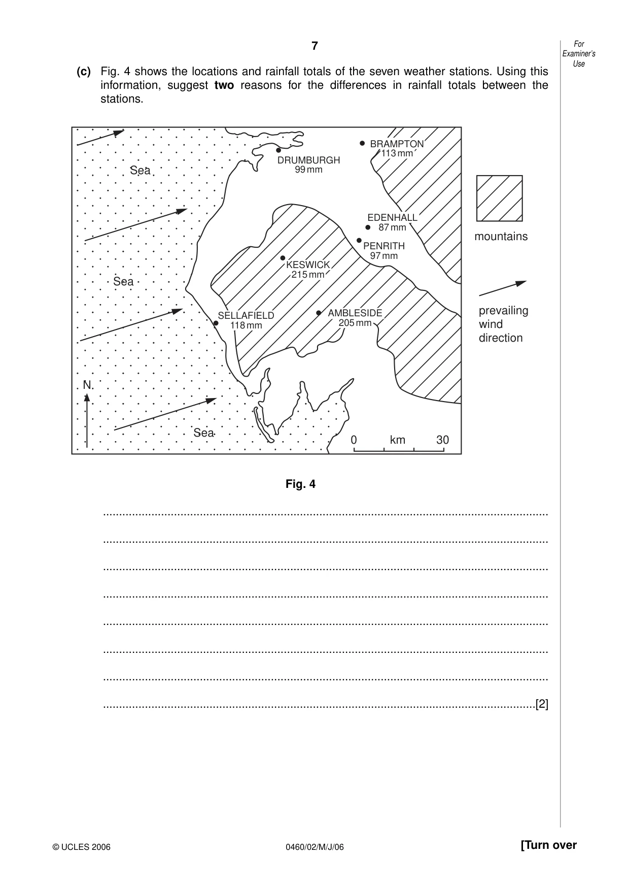
7 0460/02/M/J/06 [Turn over (c) Fig. 4 shows the locations and rainfall totals of the seven weather stations. Using this information, suggest two reasons for the differences in rainfall totals between the stations. Fig. 4 … … … … … … … …[2] N Sea Sea Sea PENRITH 97 mm DRUMBURGH 99 mm 0 km 30 BRAMPTON 113 mm EDENHALL 87 mm KESWICK 215 mm SELLAFIELD 118 mm AMBLESIDE 205 mm mountains prevailing wind direction For Examiner’s Use © UCLES 2006
Question paper, page 8
8 0460/02/M/J/06 3 Photographs A and B (Insert) show two upland areas from different climatic zones of the world. (a) Describe the relief features shown in Photograph A. … … … … … …[3] (b) Describe the vegetation and drainage shown in the two photographs. Photograph A … … … … … … Photograph B … … … … … …[5] For Examiner’s Use © UCLES 2006
Question paper, page 10
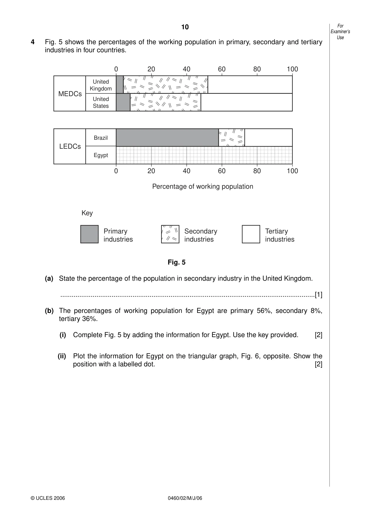
10 0460/02/M/J/06 4 Fig. 5 shows the percentages of the working population in primary, secondary and tertiary industries in four countries. Fig. 5 (a) State the percentage of the population in secondary industry in the United Kingdom. …[1] (b) The percentages of working population for Egypt are primary 56%, secondary 8%, tertiary 36%. (i) Complete Fig. 5 by adding the information for Egypt. Use the key provided. [2] (ii) Plot the information for Egypt on the triangular graph, Fig. 6, opposite. Show the position with a labelled dot. [2] 80 60 40 20 0 100 80 60 Percentage of working population 40 20 0 100 United Kingdom United States MEDCs Brazil Egypt LEDCs Key Primary industries Secondary industries Tertiary industries For Examiner’s Use © UCLES 2006
Question paper, page 11
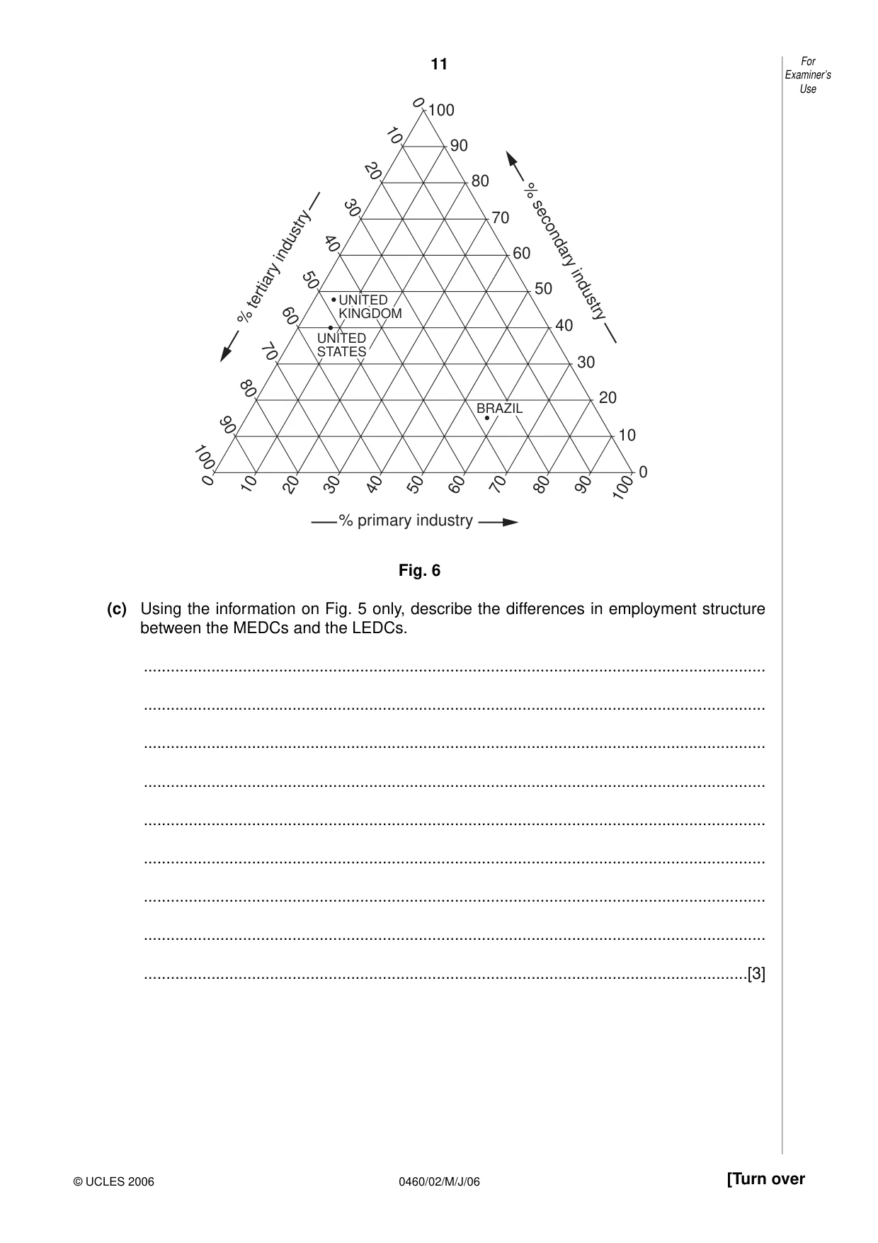
11 0460/02/M/J/06 [Turn over Fig. 6 (c) Using the information on Fig. 5 only, describe the differences in employment structure between the MEDCs and the LEDCs. … … … … … … … … …[3] 100 90 80 70 60 50 40 30 20 10 0 100 90 80 70 60 50 40 30 20 10 0 0 10 20 30 40 50 60 70 80 90 100 % tertiary industry % primary industry % secondary industry UNITED KINGDOM UNITED STATES BRAZIL For Examiner’s Use © UCLES 2006
Question paper, page 12
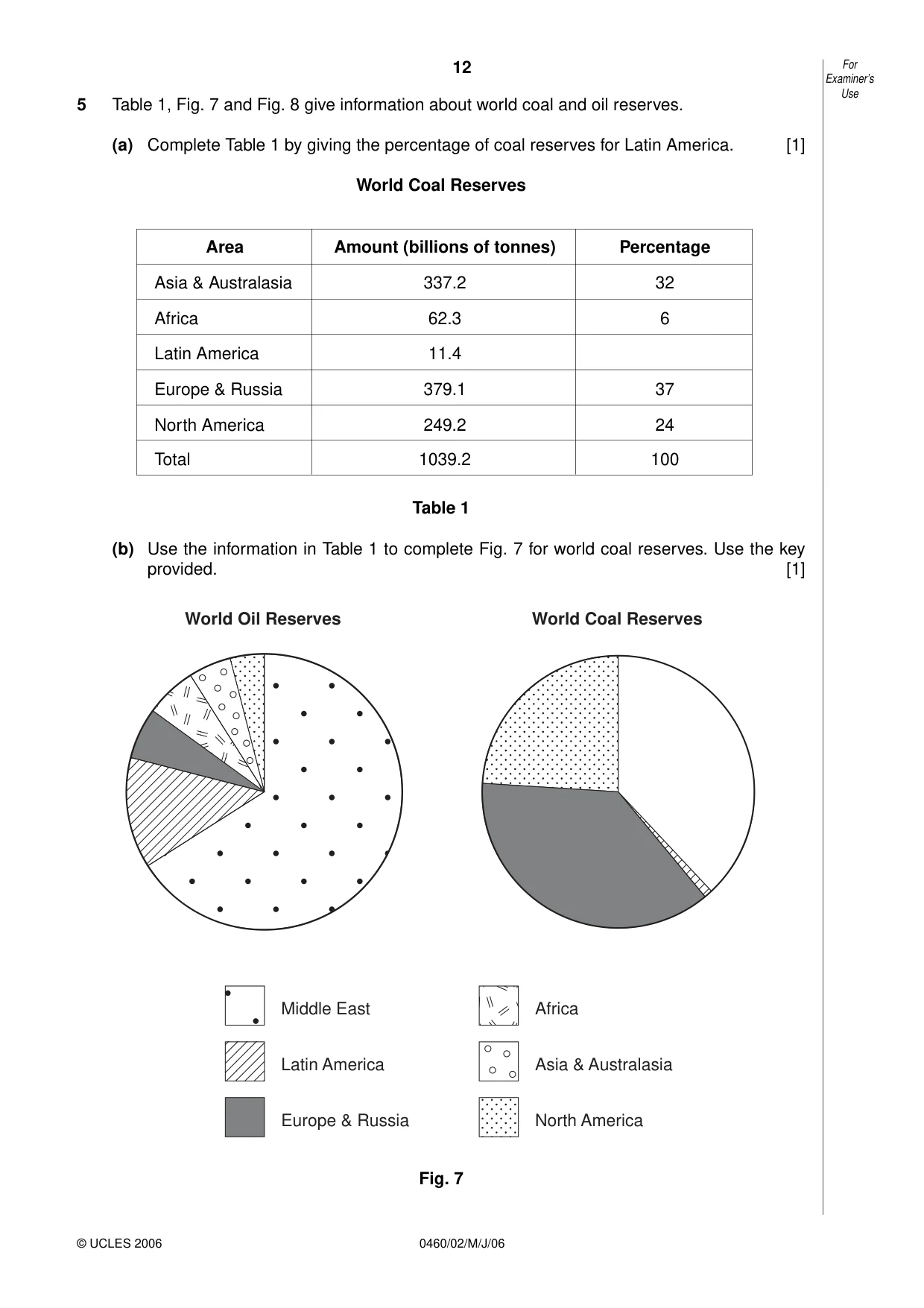
12 0460/02/M/J/06 5 Table 1, Fig. 7 and Fig. 8 give information about world coal and oil reserves. (a) Complete Table 1 by giving the percentage of coal reserves for Latin America. [1] World Coal Reserves Table 1 (b) Use the information in Table 1 to complete Fig. 7 for world coal reserves. Use the key provided. [1] Fig. 7 World Oil Reserves World Coal Reserves Middle East Latin America Europe & Russia Africa Asia & Australasia North America For Examiner’s Use © UCLES 2006 Area Amount (billions of tonnes) Percentage Asia & Australasia 337.2 32 Africa 62.3 6 Latin America 11.4 Europe & Russia 379.1 37 North America 249.2 24 Total 1039.2 100
Question paper, page 13
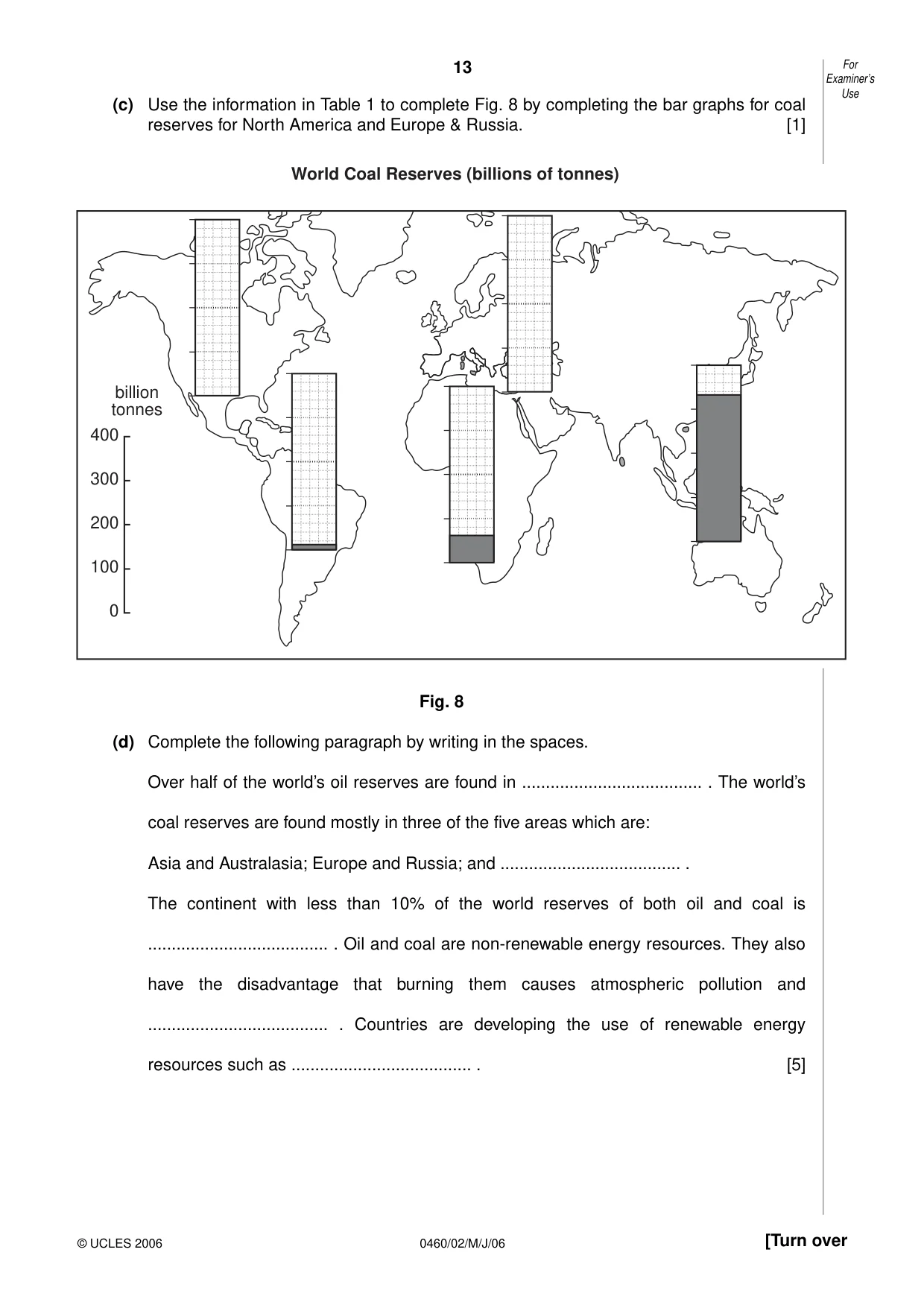
13 0460/02/M/J/06 [Turn over (c) Use the information in Table 1 to complete Fig. 8 by completing the bar graphs for coal reserves for North America and Europe & Russia. [1] Fig. 8 (d) Complete the following paragraph by writing in the spaces. Over half of the world’s oil reserves are found in … . The world’s coal reserves are found mostly in three of the five areas which are: Asia and Australasia; Europe and Russia; and … . The continent with less than 10% of the world reserves of both oil and coal is … . Oil and coal are non-renewable energy resources. They also have the disadvantage that burning them causes atmospheric pollution and … . Countries are developing the use of renewable energy resources such as … . [5] For Examiner’s Use © UCLES 2006 0 100 200 300 400 billion tonnes World Coal Reserves (billions of tonnes)
Question paper, page 14
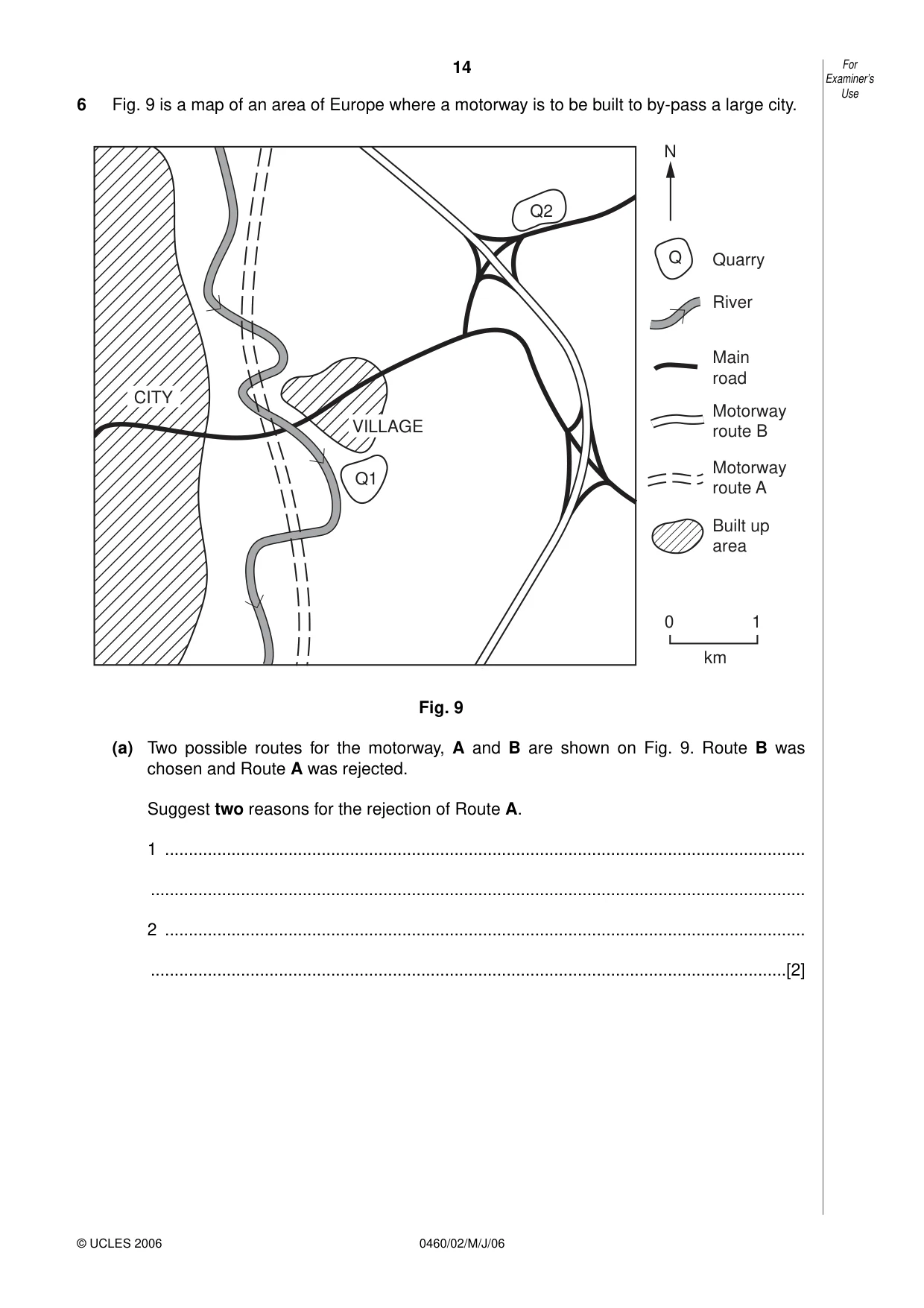
14 0460/02/M/J/06 6 Fig. 9 is a map of an area of Europe where a motorway is to be built to by-pass a large city. Fig. 9 (a) Two possible routes for the motorway, A and B are shown on Fig. 9. Route B was chosen and Route A was rejected. Suggest two reasons for the rejection of Route A. 1 … … 2 … …[2] CITY Q2 VILLAGE Q1 N Quarry River Main road Motorway route B Motorway route A Built up area Q 0 1 km For Examiner’s Use © UCLES 2006
Question paper, page 15
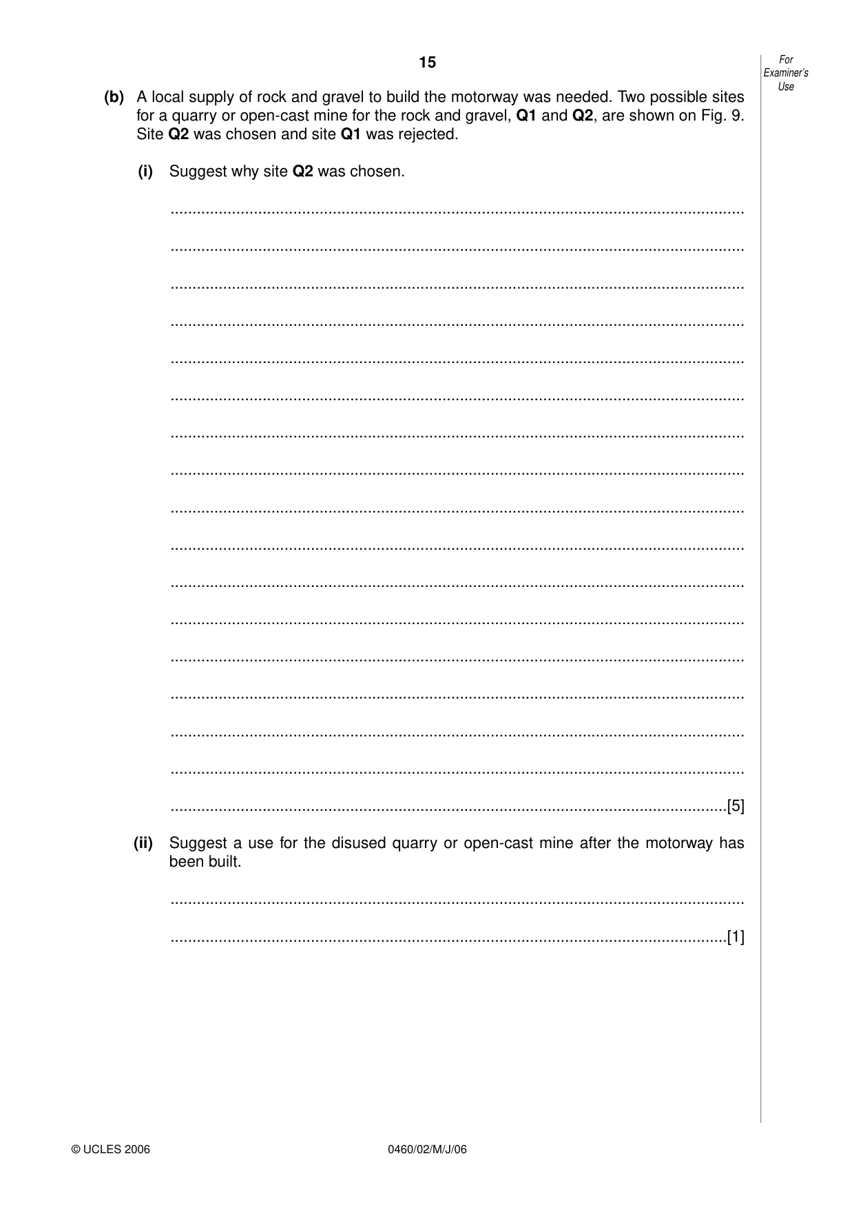
15 0460/02/M/J/06 (b) A local supply of rock and gravel to build the motorway was needed. Two possible sites for a quarry or open-cast mine for the rock and gravel, Q1 and Q2, are shown on Fig. 9. Site Q2 was chosen and site Q1 was rejected. (i) Suggest why site Q2 was chosen. … … … … … … … … … … … … … … … … …[5] (ii) Suggest a use for the disused quarry or open-cast mine after the motorway has been built. … …[1] For Examiner’s Use © UCLES 2006
Question paper, page 16
16 0460/02/M/J/06 BLANK PAGE Copyright Acknowledgements: Question 1 © Director of Surveys, Jamaica. Question 2 Fig. 3 © HIGCSE Geography Module 4, Cambridge University Press. Question 3 Photographs A & B; D. Kelly © UCLES. Question 5 Table 1 & Fig. 7 © Collins Bartholomew Ltd 1994. Reproduced by Kind Permission of HarperCollins Publishers. Permission to reproduce items where third-party owned material protected by copyright is included has been sought and cleared where possible. Every reasonable effort has been made by the publisher (UCLES) to trace copyright holders, but if any items requiring clearance have unwittingly been included, the publisher will be pleased to make amends at the earliest possible opportunity. University of Cambridge International Examinations is part of the University of Cambridge Local Examinations Syndicate (UCLES), which is itself a department of the University of Cambridge.
Mark scheme, page 1
UNIVERSITY OF CAMBRIDGE INTERNATIONAL EXAMINATIONS International General Certificate of Secondary Education MARK SCHEME for the May/June 2006 question paper 0460 GEOGRAPHY 0460/02 Paper 2 maximum raw mark 60 This mark scheme is published as an aid to teachers and students, to indicate the requirements of the examination. It shows the basis on which Examiners were initially instructed to award marks. It does not indicate the details of the discussions that took place at an Examiners’ meeting before marking began. Any substantial changes to the mark scheme that arose from these discussions will be recorded in the published Report on the Examination. All Examiners are instructed that alternative correct answers and unexpected approaches in candidates’ scripts must be given marks that fairly reflect the relevant knowledge and skills demonstrated. Mark schemes must be read in conjunction with the question papers and the Report on the Examination. The minimum marks in these components needed for various grades were previously published with these mark schemes, but are now instead included in the Report on the Examination for this session. • CIE will not enter into discussion or correspondence in connection with these mark schemes. CIE is publishing the mark schemes for the May/June 2006 question papers for most IGCSE and GCE Advanced Level and Advanced Subsidiary Level syllabuses and some Ordinary Level syllabuses. www.XtremePapers.com
Mark scheme, page 2
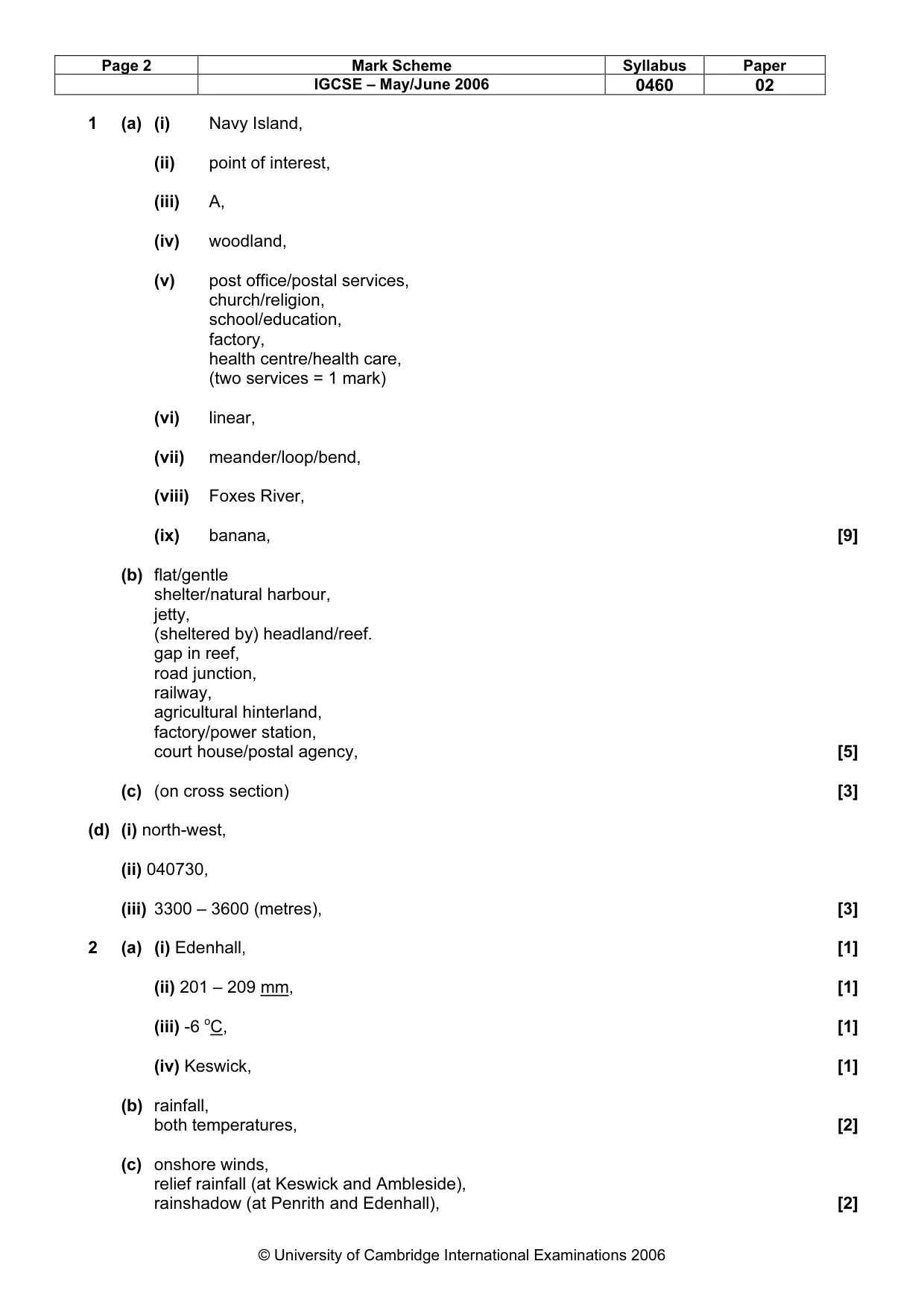
Page 2 Mark Scheme Syllabus Paper IGCSE – May/June 2006 0460 02 © University of Cambridge International Examinations 2006 1 (a) (i) Navy Island, (ii) point of interest, (iii) A, (iv) woodland, (v) post office/postal services, church/religion, school/education, factory, health centre/health care, (two services = 1 mark) (vi) linear, (vii) meander/loop/bend, (viii) Foxes River, (ix) banana, [9] (b) flat/gentle shelter/natural harbour, jetty, (sheltered by) headland/reef. gap in reef, road junction, railway, agricultural hinterland, factory/power station, court house/postal agency, [5] (c) (on cross section) [3] (d) (i) north-west, (ii) 040730, (iii) 3300 – 3600 (metres), [3] 2 (a) (i) Edenhall, [1] (ii) 201 – 209 mm, [1] (iii) -6 oC, [1] (iv) Keswick, [1] (b) rainfall, both temperatures, [2] (c) onshore winds, relief rainfall (at Keswick and Ambleside), rainshadow (at Penrith and Edenhall), [2]
Mark scheme, page 3
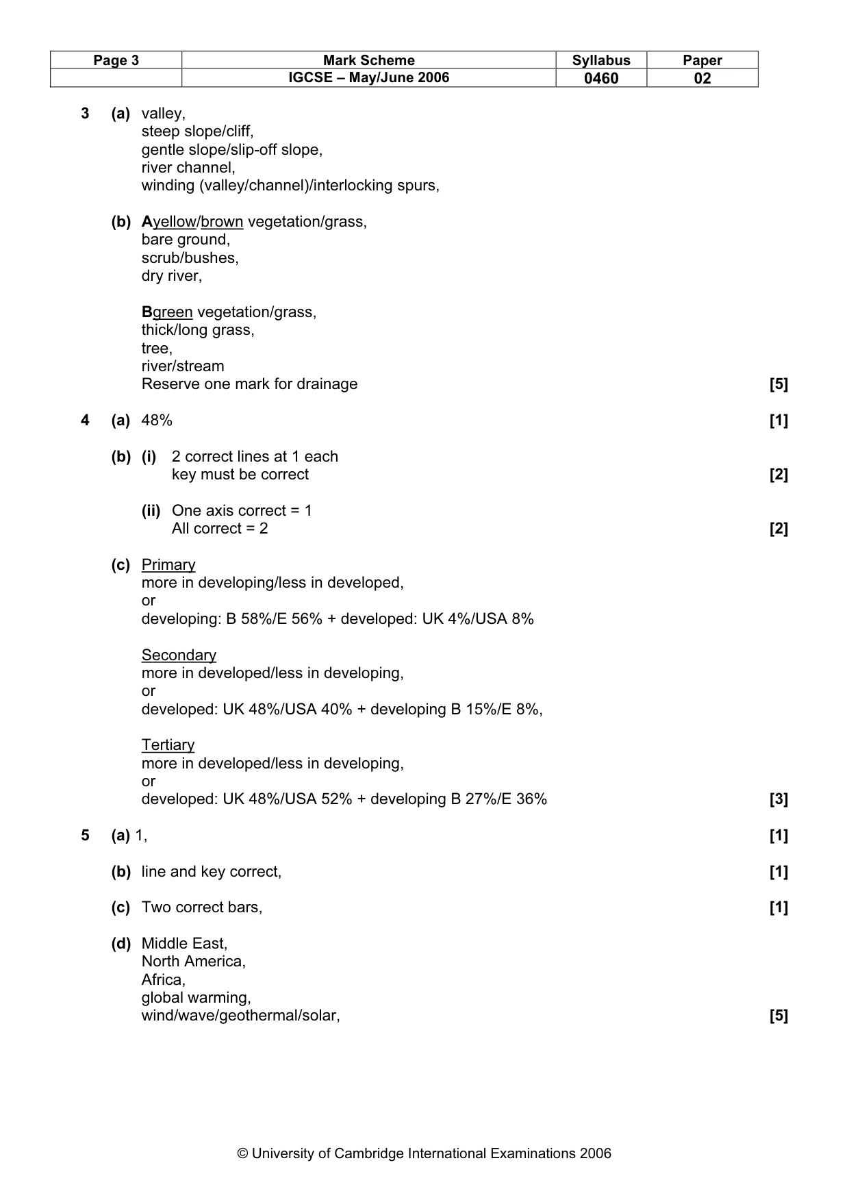
Page 3 Mark Scheme Syllabus Paper IGCSE – May/June 2006 0460 02 © University of Cambridge International Examinations 2006 3 (a) valley, steep slope/cliff, gentle slope/slip-off slope, river channel, winding (valley/channel)/interlocking spurs, (b) Ayellow/brown vegetation/grass, bare ground, scrub/bushes, dry river, Bgreen vegetation/grass, thick/long grass, tree, river/stream Reserve one mark for drainage [5] 4 (a) 48% [1] (b) (i) 2 correct lines at 1 each key must be correct [2] (ii) One axis correct = 1 All correct = 2 [2] (c) Primary more in developing/less in developed, or developing: B 58%/E 56% + developed: UK 4%/USA 8% Secondary more in developed/less in developing, or developed: UK 48%/USA 40% + developing B 15%/E 8%, Tertiary more in developed/less in developing, or developed: UK 48%/USA 52% + developing B 27%/E 36% [3] 5 (a) 1, [1] (b) line and key correct, [1] (c) Two correct bars, [1] (d) Middle East, North America, Africa, global warming, wind/wave/geothermal/solar, [5]
Mark scheme, page 4
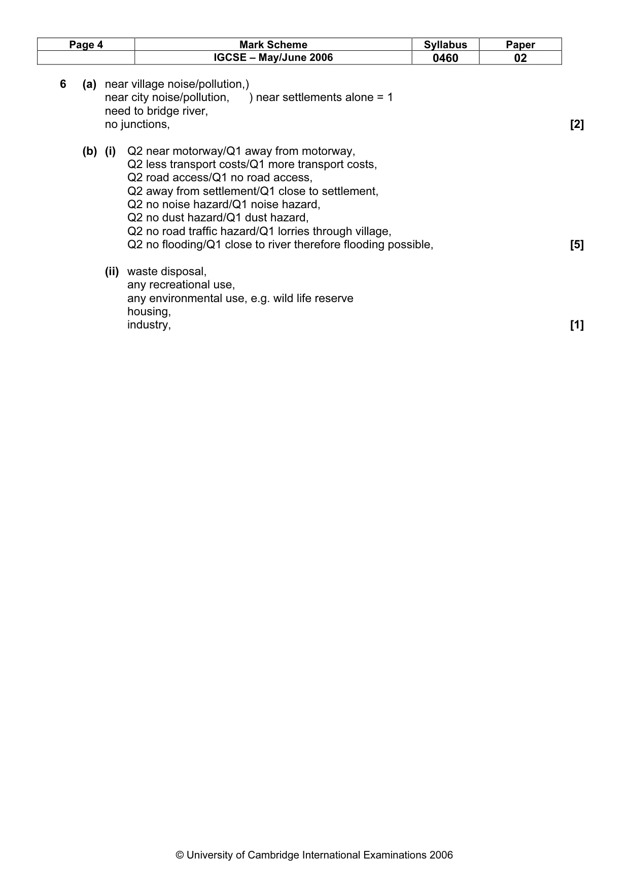
Page 4 Mark Scheme Syllabus Paper IGCSE – May/June 2006 0460 02 © University of Cambridge International Examinations 2006 6 (a) near village noise/pollution,) near city noise/pollution, ) near settlements alone = 1 need to bridge river, no junctions, [2] (b) (i) Q2 near motorway/Q1 away from motorway, Q2 less transport costs/Q1 more transport costs, Q2 road access/Q1 no road access, Q2 away from settlement/Q1 close to settlement, Q2 no noise hazard/Q1 noise hazard, Q2 no dust hazard/Q1 dust hazard, Q2 no road traffic hazard/Q1 lorries through village, Q2 no flooding/Q1 close to river therefore flooding possible, [5] (ii) waste disposal, any recreational use, any environmental use, e.g. wild life reserve housing, industry, [1]
What you needed in this session
Cambridge’s own grade thresholds for 2006 May/June, Paper 2 · Variant 1. A higher threshold means an easier paper — the bar moves with how the cohort did.