Cambridge IGCSE Geography 0460 — 2005 Oct/Nov Paper 2 · Variant 1
0460/21/O/N/05
The question paper and its mark scheme, free to read here and free to download. This is Cambridge’s own paper, exactly as it was sat.
Question paper8 pages
Mark scheme5 pages
Answers below. Sit the paper first if you are practising.

Paper as text
Question paper, page 1
This document consists of 8 printed pages and 2 inserts. SPA (DR) S84508/2 © UCLES 2005 [Turn over UNIVERSITY OF CAMBRIDGE INTERNATIONAL EXAMINATIONS International General Certificate of Secondary Education GEOGRAPHY 0460/02 Paper 2 October/November 2005 1 hour 30 minutes Additional Materials: Answer Booklet/Paper, Ruler (cm:mm) Protractor Set square 1:25000 Survey Map Extract is enclosed with this question paper. READ THESE INSTRUCTIONS FIRST If you have been given an Answer Booklet, follow the instructions on the front cover of the Booklet. Write your Centre number, candidate number and name on all the work you hand in. Write in dark blue or black pen on both sides of the paper. You may use a soft pencil for any diagrams, graphs or rough working. Do not use staples, paper clips, highlighters, glue or correction fluid. Answer all questions. At the end of the examination, fasten all your work securely together. The number of marks is given in brackets [ ] at the end of each question or part question. Insert 1 contains Fig. 2 for Question 2, Fig. 3 and Table 1 for Question 3 and Fig. 6 for Question 5. Insert 2 contains Photograph A for Question 4. Sketch maps and diagrams should be drawn whenever they serve to illustrate an answer. www.XtremePapers.com
Question paper, page 2
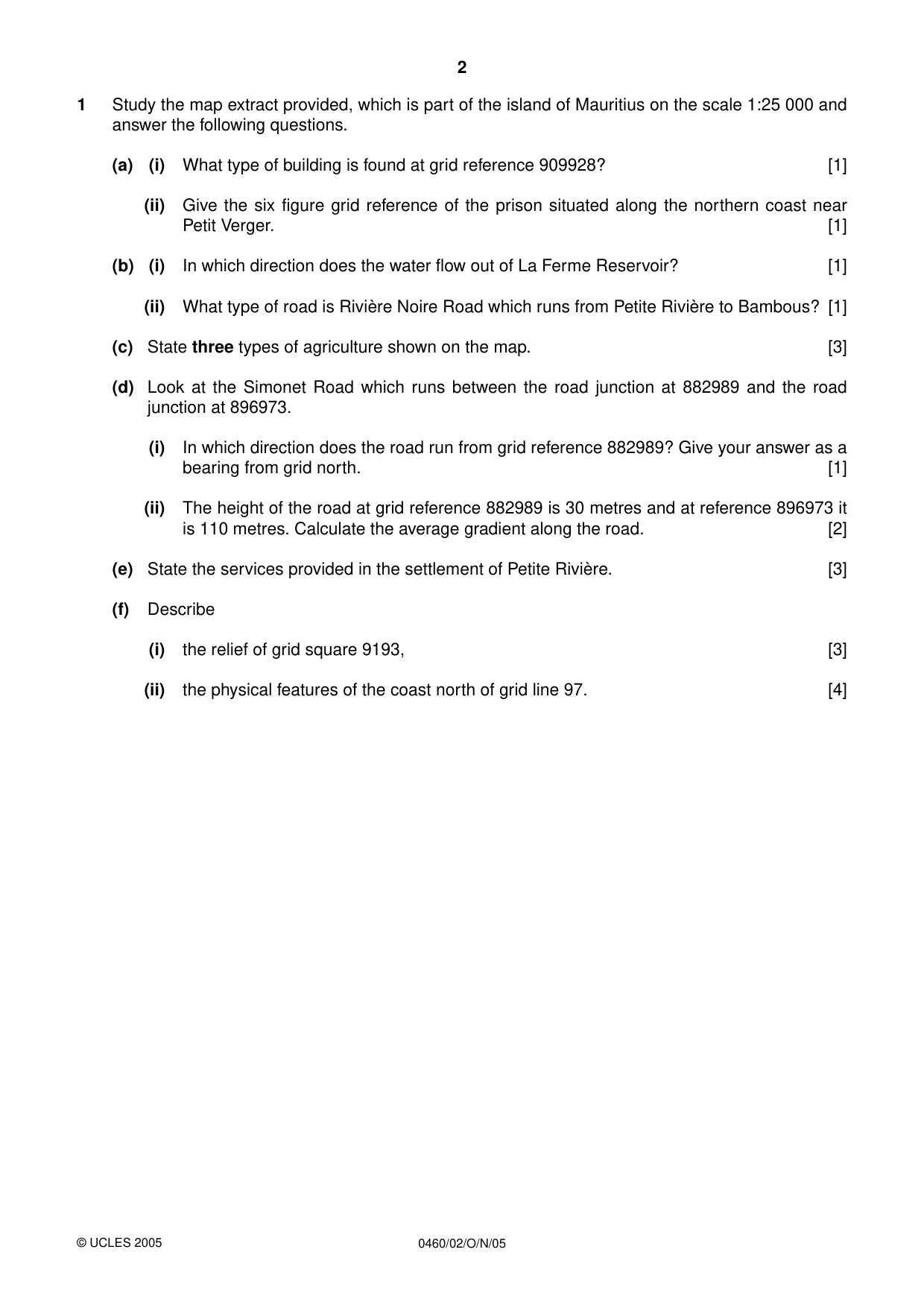
2 0460/02/O/N/05 1 Study the map extract provided, which is part of the island of Mauritius on the scale 1:25 000 and answer the following questions. (a) (i) What type of building is found at grid reference 909928? [1] (ii) Give the six figure grid reference of the prison situated along the northern coast near Petit Verger. [1] (b) (i) In which direction does the water flow out of La Ferme Reservoir? [1] (ii) What type of road is Rivière Noire Road which runs from Petite Rivière to Bambous? [1] (c) State three types of agriculture shown on the map. [3] (d) Look at the Simonet Road which runs between the road junction at 882989 and the road junction at 896973. (i) In which direction does the road run from grid reference 882989? Give your answer as a bearing from grid north. [1] (ii) The height of the road at grid reference 882989 is 30 metres and at reference 896973 it is 110 metres. Calculate the average gradient along the road. [2] (e) State the services provided in the settlement of Petite Rivière. [3] (f) Describe (i) the relief of grid square 9193, [3] (ii) the physical features of the coast north of grid line 97. [4] © UCLES 2005
Question paper, page 3
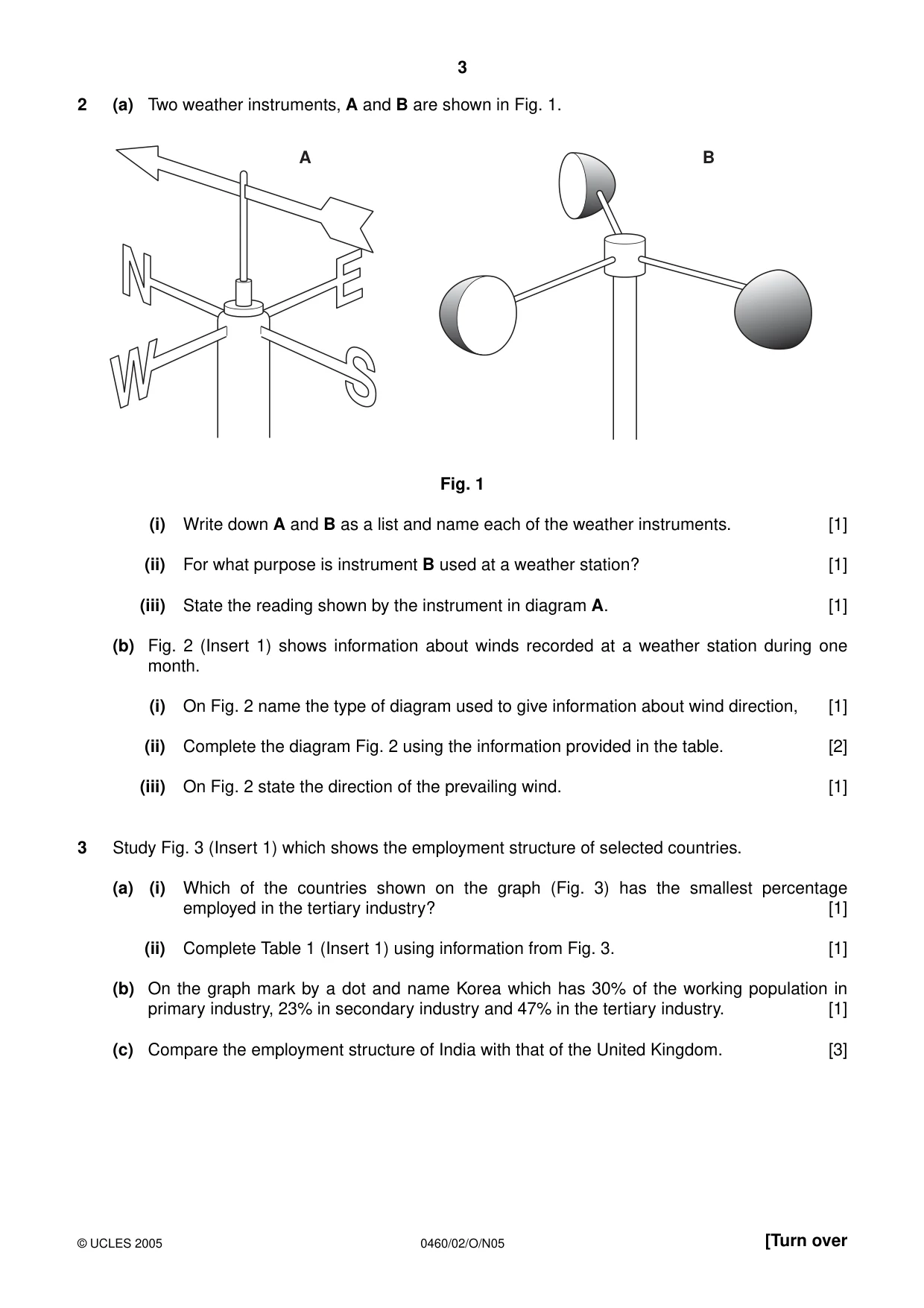
3 0460/02/O/N05 [Turn over 2 (a) Two weather instruments, A and B are shown in Fig. 1. Fig. 1 (i) Write down A and B as a list and name each of the weather instruments. [1] (ii) For what purpose is instrument B used at a weather station? [1] (iii) State the reading shown by the instrument in diagram A. [1] (b) Fig. 2 (Insert 1) shows information about winds recorded at a weather station during one month. (i) On Fig. 2 name the type of diagram used to give information about wind direction, [1] (ii) Complete the diagram Fig. 2 using the information provided in the table. [2] (iii) On Fig. 2 state the direction of the prevailing wind. [1] 3 Study Fig. 3 (Insert 1) which shows the employment structure of selected countries. (a) (i) Which of the countries shown on the graph (Fig. 3) has the smallest percentage employed in the tertiary industry? [1] (ii) Complete Table 1 (Insert 1) using information from Fig. 3. [1] (b) On the graph mark by a dot and name Korea which has 30% of the working population in primary industry, 23% in secondary industry and 47% in the tertiary industry. [1] (c) Compare the employment structure of India with that of the United Kingdom. [3] A B © UCLES 2005
Question paper, page 4
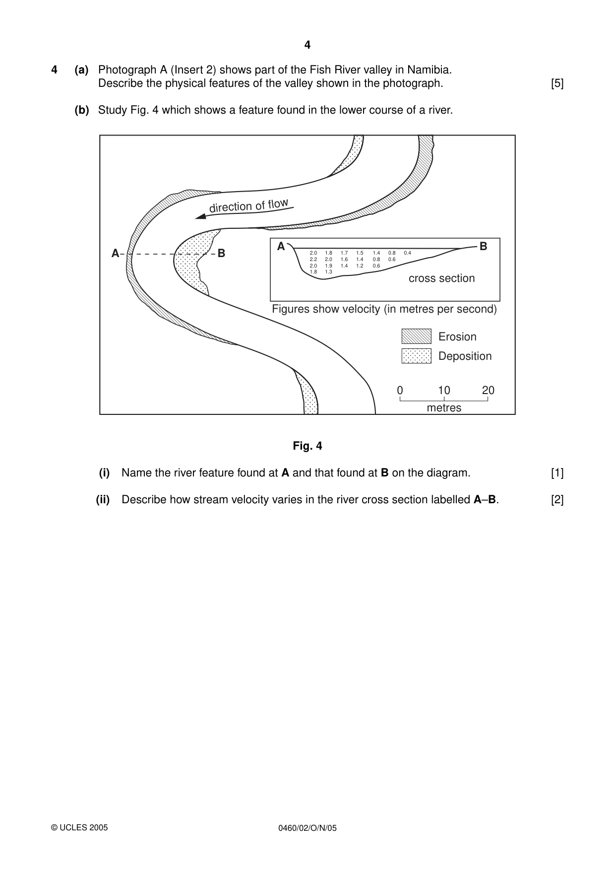
4 0460/02/O/N/05 4 (a) Photograph A (Insert 2) shows part of the Fish River valley in Namibia. Describe the physical features of the valley shown in the photograph. [5] (b) Study Fig. 4 which shows a feature found in the lower course of a river. Fig. 4 (i) Name the river feature found at A and that found at B on the diagram. [1] (ii) Describe how stream velocity varies in the river cross section labelled A–B. [2] A A B B dir ecti on o f f low 2.0 2.2 2.0 1.8 1.8 2.0 1.9 1.3 1.7 1.6 1.4 1.5 1.4 1.2 1.4 0.8 0.6 0.8 0.6 0.4 Figures show velocity (in metres per second) Erosion cross section Deposition 0 10 metres 20 © UCLES 2005
Question paper, page 5
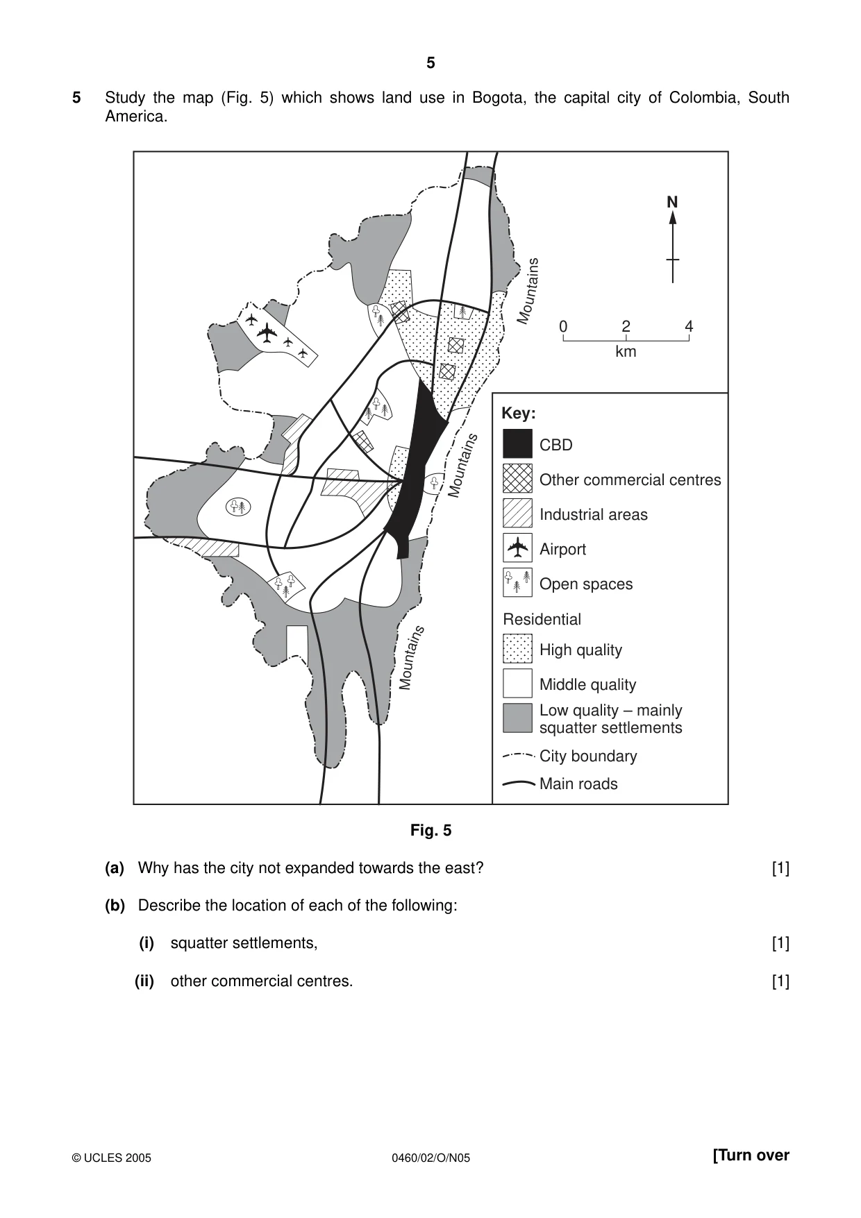
5 0460/02/O/N05 [Turn over 5 Study the map (Fig. 5) which shows land use in Bogota, the capital city of Colombia, South America. Fig. 5 (a) Why has the city not expanded towards the east? [1] (b) Describe the location of each of the following: (i) squatter settlements, [1] (ii) other commercial centres. [1] CBD Other commercial centres Industrial areas Airport Open spaces High quality Middle quality City boundary Main roads Low quality – mainly squatter settlements Key: Residential Mo un t a i n s Mo unt ain s M o u nt a i n s 0 2 km 4 N © UCLES 2005
Question paper, page 6
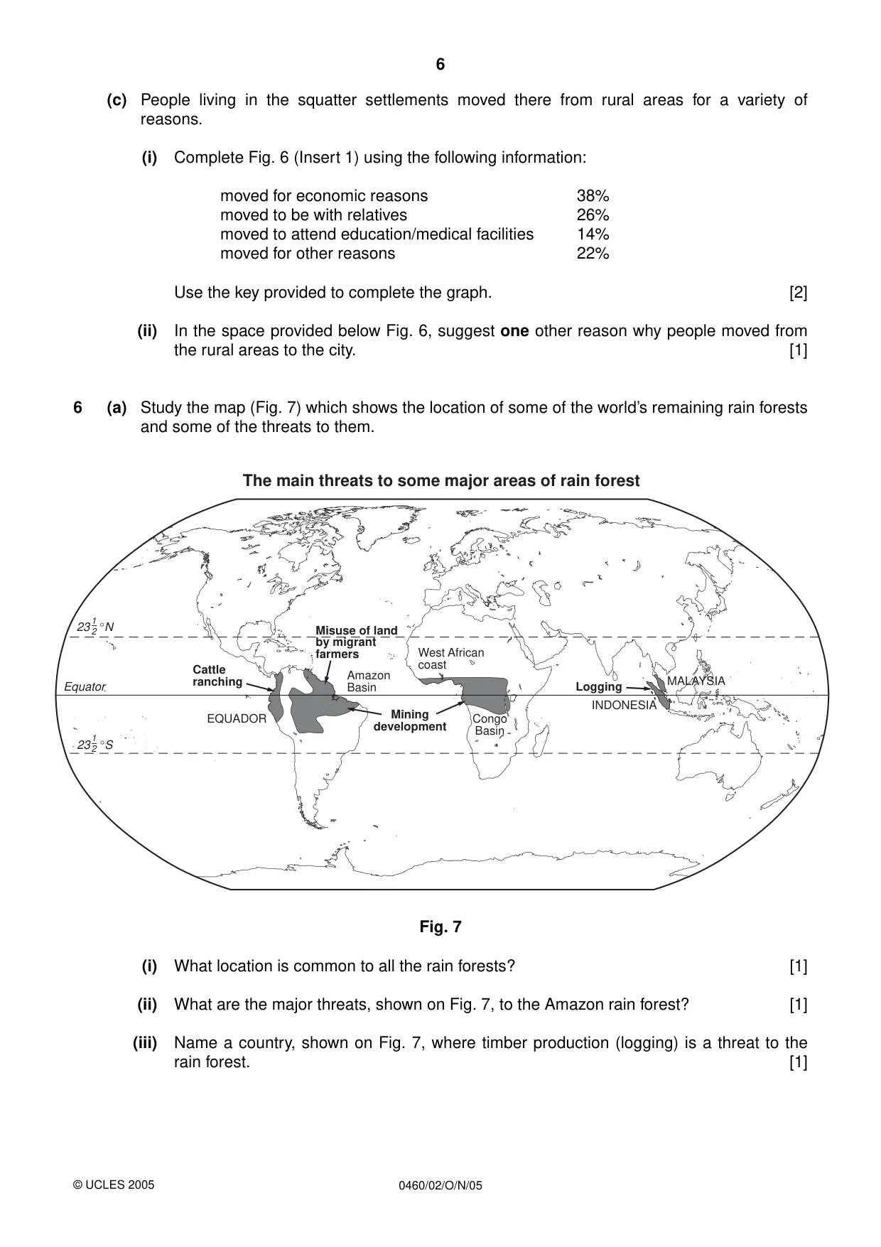
6 0460/02/O/N/05 (c) People living in the squatter settlements moved there from rural areas for a variety of reasons. (i) Complete Fig. 6 (Insert 1) using the following information: moved for economic reasons 38% moved to be with relatives 26% moved to attend education/medical facilities 14% moved for other reasons 22% Use the key provided to complete the graph. [2] (ii) In the space provided below Fig. 6, suggest one other reason why people moved from the rural areas to the city. [1] 6 (a) Study the map (Fig. 7) which shows the location of some of the world’s remaining rain forests and some of the threats to them. Fig. 7 (i) What location is common to all the rain forests? [1] (ii) What are the major threats, shown on Fig. 7, to the Amazon rain forest? [1] (iii) Name a country, shown on Fig. 7, where timber production (logging) is a threat to the rain forest. [1] © UCLES 2005 Cattle ranching Misuse of land by migrant farmers Mining development Logging EQUADOR Amazon Basin INDONESIA MALAYSIA Congo Basin West African coast Equator 23 °N 1–2 23 °S 1–2 The main threats to some major areas of rain forest
Question paper, page 7
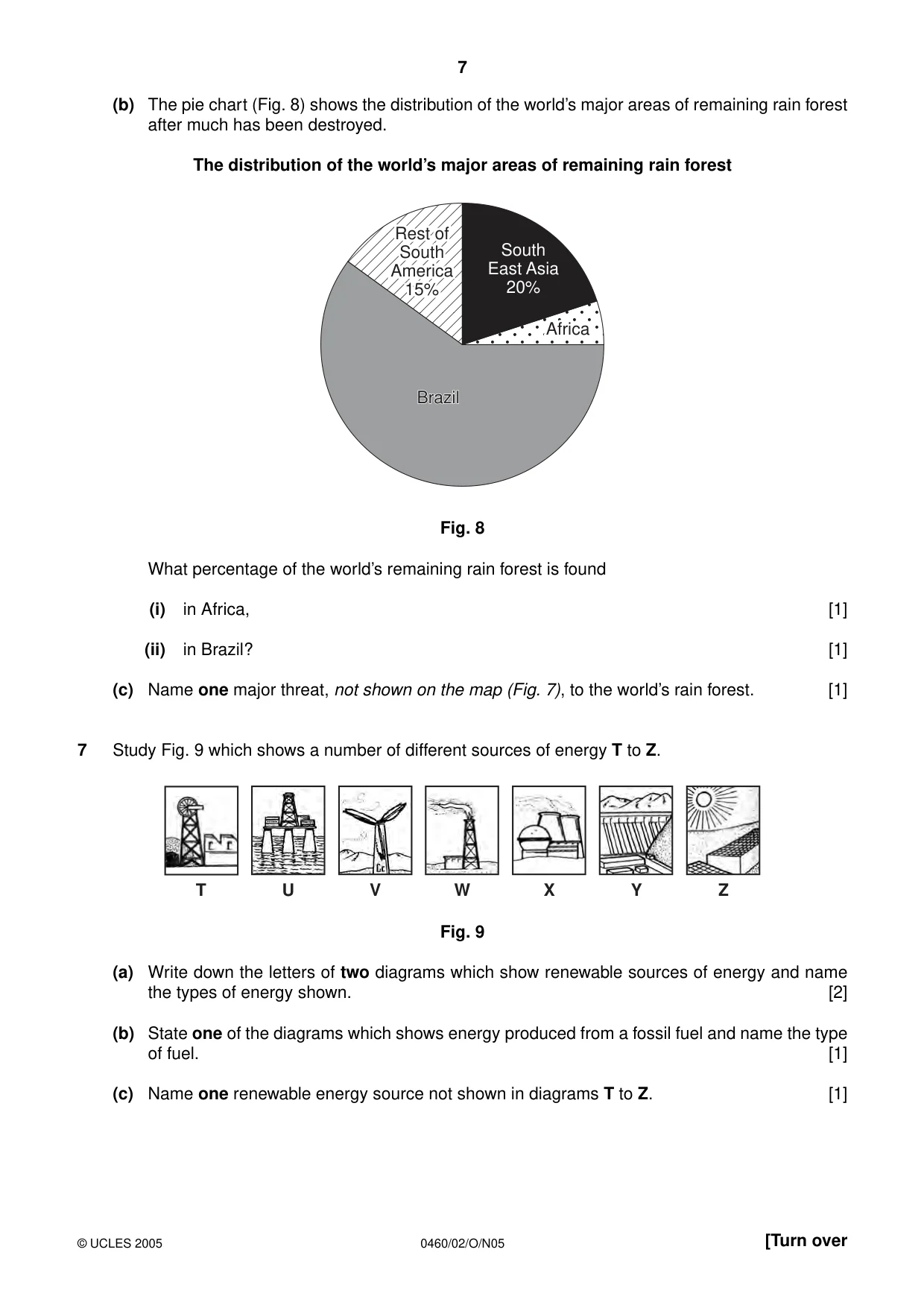
7 0460/02/O/N05 [Turn over (b) The pie chart (Fig. 8) shows the distribution of the world’s major areas of remaining rain forest after much has been destroyed. The distribution of the world’s major areas of remaining rain forest Fig. 8 What percentage of the world’s remaining rain forest is found (i) in Africa, [1] (ii) in Brazil? [1] (c) Name one major threat, not shown on the map (Fig. 7), to the world’s rain forest. [1] 7 Study Fig. 9 which shows a number of different sources of energy T to Z. Fig. 9 (a) Write down the letters of two diagrams which show renewable sources of energy and name the types of energy shown. [2] (b) State one of the diagrams which shows energy produced from a fossil fuel and name the type of fuel. [1] (c) Name one renewable energy source not shown in diagrams T to Z. [1] T U V W X Y Z South East Asia 20% Africa Africa Rest of Rest of South South America America 15% 15% Rest of South America 15% Africa Brazil Brazil Brazil © UCLES 2005
Question paper, page 8
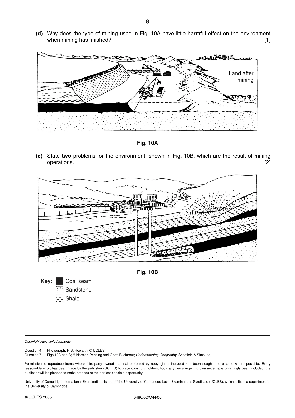
8 0460/02/O/N/05 (d) Why does the type of mining used in Fig. 10A have little harmful effect on the environment when mining has finished? [1] Fig. 10A (e) State two problems for the environment, shown in Fig. 10B, which are the result of mining operations. [2] Fig. 10B Key: Coal seam Sandstone Shale © UCLES 2005 Copyright Acknowledgements: Question 4 Photograph; R.B. Howarth, © UCLES. Question 7 Figs 10A and B; © Norman Pantling and Geoff Bucktrout; Understanding Geography; Schofield & Sims Ltd. Permission to reproduce items where third-party owned material protected by copyright is included has been sought and cleared where possible. Every reasonable effort has been made by the publisher (UCLES) to trace copyright holders, but if any items requiring clearance have unwittingly been included, the publisher will be pleased to make amends at the earliest possible opportunity. University of Cambridge International Examinations is part of the University of Cambridge Local Examinations Syndicate (UCLES), which is itself a department of the University of Cambridge.
Mark scheme, page 1
UNIVERSITY OF CAMBRIDGE INTERNATIONAL EXAMINATIONS International General Certificate of Secondary Education MARK SCHEME for the October/November 2005 question paper 0460 GEOGRAPHY 0460/02 Paper 2, maximum mark 60 This mark scheme is published as an aid to teachers and students, to indicate the requirements of the examination. It shows the basis on which Examiners were initially instructed to award marks. It does not indicate the details of the discussions that took place at an Examiners’ meeting before marking began. Any substantial changes to the mark scheme that arose from these discussions will be recorded in the published Report on the Examination. All Examiners are instructed that alternative correct answers and unexpected approaches in candidates’ scripts must be given marks that fairly reflect the relevant knowledge and skills demonstrated. Mark schemes must be read in conjunction with the question papers and the Report on the Examination. • CIE will not enter into discussion or correspondence in connection with these mark schemes. The minimum marks in these components needed for various grades were previously published with these mark schemes, but are now instead included in the Report on the Examination for this session. CIE is publishing the mark schemes for the October/November 2005 question papers for most IGCSE and GCE Advanced Level and Advanced Subsidiary Level syllabuses and some Ordinary Level syllabuses. www.XtremePapers.com
Mark scheme, page 2
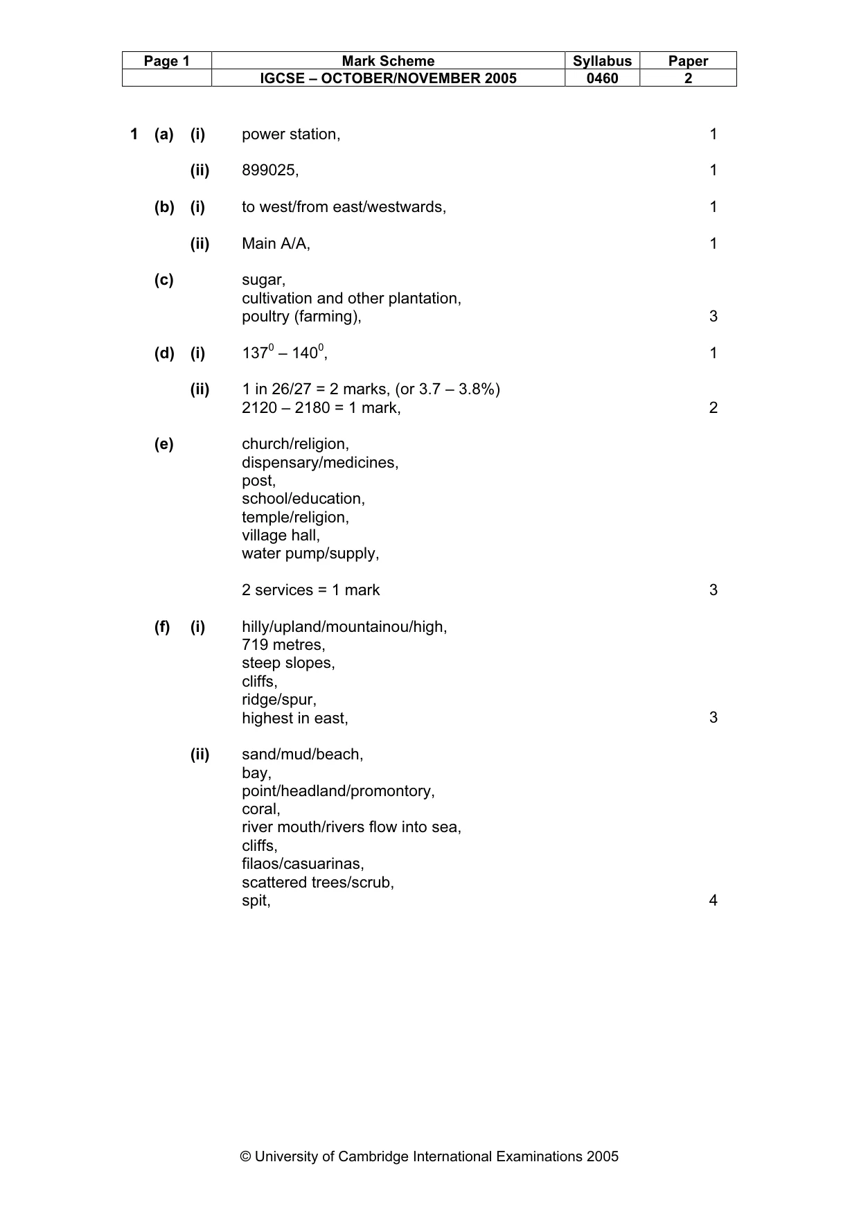
Page 1 Mark Scheme Syllabus Paper IGCSE – OCTOBER/NOVEMBER 2005 0460 2 © University of Cambridge International Examinations 2005 1 (a) (i) power station, 1 (ii) 899025, 1 (b) (i) to west/from east/westwards, 1 (ii) Main A/A, 1 (c) sugar, cultivation and other plantation, poultry (farming), 3 (d) (i) 1370 – 1400, 1 (ii) 1 in 26/27 = 2 marks, (or 3.7 – 3.8%) 2120 – 2180 = 1 mark, 2 (e) church/religion, dispensary/medicines, post, school/education, temple/religion, village hall, water pump/supply, 2 services = 1 mark 3 (f) (i) hilly/upland/mountainou/high, 719 metres, steep slopes, cliffs, ridge/spur, highest in east, 3 (ii) sand/mud/beach, bay, point/headland/promontory, coral, river mouth/rivers flow into sea, cliffs, filaos/casuarinas, scattered trees/scrub, spit, 4
Mark scheme, page 3
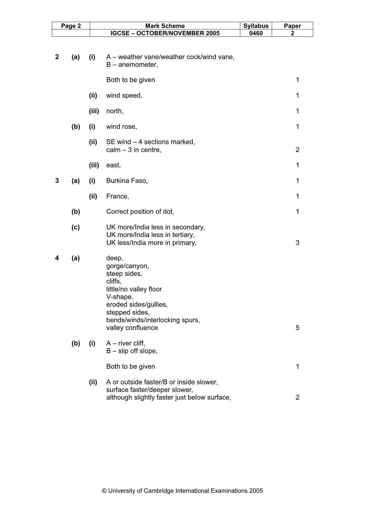
Page 2 Mark Scheme Syllabus Paper IGCSE – OCTOBER/NOVEMBER 2005 0460 2 © University of Cambridge International Examinations 2005 2 (a) (i) A – weather vane/weather cock/wind vane, B – anemometer, Both to be given 1 (ii) wind speed, 1 (iii) north, 1 (b) (i) wind rose, 1 (ii) SE wind – 4 sections marked, calm – 3 in centre, 2 (iii) east, 1 3 (a) (i) Burkina Faso, 1 (ii) France, 1 (b) Correct position of dot, 1 (c) UK more/India less in secondary, UK more/India less in tertiary, UK less/India more in primary, 3 4 (a) deep, gorge/canyon, steep sides, cliffs, little/no valley floor V-shape, eroded sides/gullies, stepped sides, bends/winds/interlocking spurs, valley confluence 5 (b) (i) A – river cliff, B – slip off slope, Both to be given 1 (ii) A or outside faster/B or inside slower, surface faster/deeper slower, although slightly faster just below surface, 2
Mark scheme, page 4
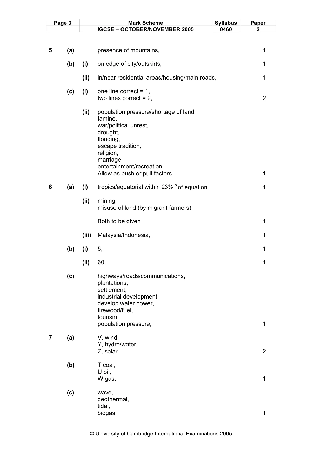
Page 3 Mark Scheme Syllabus Paper IGCSE – OCTOBER/NOVEMBER 2005 0460 2 © University of Cambridge International Examinations 2005 5 (a) presence of mountains, 1 (b) (i) on edge of city/outskirts, 1 (ii) in/near residential areas/housing/main roads, 1 (c) (i) one line correct = 1, two lines correct = 2, 2 (ii) population pressure/shortage of land famine, war/political unrest, drought, flooding, escape tradition, religion, marriage, entertainment/recreation Allow as push or pull factors 1 6 (a) (i) tropics/equatorial within 23½ o of equation 1 (ii) mining, misuse of land (by migrant farmers), Both to be given 1 (iii) Malaysia/Indonesia, 1 (b) (i) 5, 1 (ii) 60, 1 (c) highways/roads/communications, plantations, settlement, industrial development, develop water power, firewood/fuel, tourism, population pressure, 1 7 (a) V, wind, Y, hydro/water, Z, solar 2 (b) T coal, U oil, W gas, 1 (c) wave, geothermal, tidal, biogas 1
Mark scheme, page 5
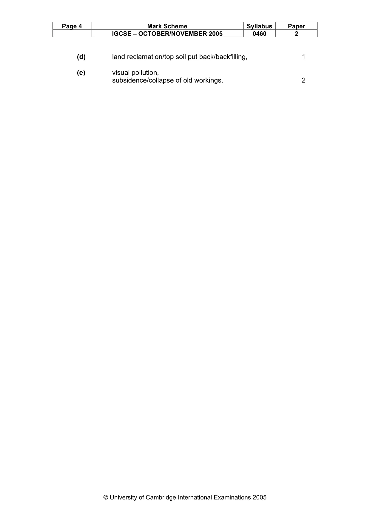
Page 4 Mark Scheme Syllabus Paper IGCSE – OCTOBER/NOVEMBER 2005 0460 2 © University of Cambridge International Examinations 2005 (d) land reclamation/top soil put back/backfilling, 1 (e) visual pollution, subsidence/collapse of old workings, 2