Cambridge IGCSE Geography 0460 — 2004 May/June Paper 2 · Variant 1
0460/21/M/J/04
The question paper and its mark scheme, free to read here and free to download. This is Cambridge’s own paper, exactly as it was sat.
Question paper8 pages

Mark scheme
No mark scheme is in the library for this paper.
Paper as text
Question paper, page 1
This document consists of 8 printed pages and 2 inserts. (DR) S57723/5 © UCLES 2004 [Turn over UNIVERSITY OF CAMBRIDGE INTERNATIONAL EXAMINATIONS International General Certificate of Secondary Education GEOGRAPHY 0460/02 Paper 2 May/June 2004 1 hour 30 minutes Additional Materials: Answer Booklet/Paper; Ruler; Protractor; 1:25000 Survey Map Extract is enclosed with this question paper. READ THESE INSTRUCTIONS FIRST If you have been given an Answer Booklet, follow the instructions on the front cover of the Booklet. Write your Centre number, candidate number and name on all the work you hand in. Write in dark blue or black pen on both sides of the paper. You may use a soft pencil for any diagrams, graphs or rough working. Do not use staples, paper clips, highlighters, glue or correction fluid. Answer all questions. At the end of the examination, fasten all your work securely together. The number of marks is given in brackets [ ] at the end of each question or part question. Insert 1 contains Fig.1 for Question 2, Fig. 2 for Question 3 and Fig. 5 for Question 6. Insert 2 contains Photograph A for Question 3. Sketch maps and diagrams should be drawn whenever they serve to illustrate an answer. www.XtremePapers.com
Question paper, page 2
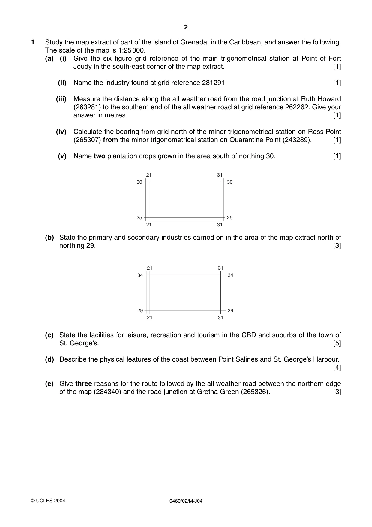
2 0460/02/M/J04 1 Study the map extract of part of the island of Grenada, in the Caribbean, and answer the following. The scale of the map is 1:25000. (a) (i) Give the six figure grid reference of the main trigonometrical station at Point of Fort Jeudy in the south-east corner of the map extract. [1] (ii) Name the industry found at grid reference 281291. [1] (iii) Measure the distance along the all weather road from the road junction at Ruth Howard (263281) to the southern end of the all weather road at grid reference 262262. Give your answer in metres. [1] (iv) Calculate the bearing from grid north of the minor trigonometrical station on Ross Point (265307) from the minor trigonometrical station on Quarantine Point (243289). [1] (v) Name two plantation crops grown in the area south of northing 30. [1] (b) State the primary and secondary industries carried on in the area of the map extract north of northing 29. [3] (c) State the facilities for leisure, recreation and tourism in the CBD and suburbs of the town of St. George’s. [5] (d) Describe the physical features of the coast between Point Salines and St. George’s Harbour. [4] (e) Give three reasons for the route followed by the all weather road between the northern edge of the map (284340) and the road junction at Gretna Green (265326). [3] 34 21 31 21 31 34 29 29 30 21 31 21 31 30 25 25 © UCLES 2004
Question paper, page 3
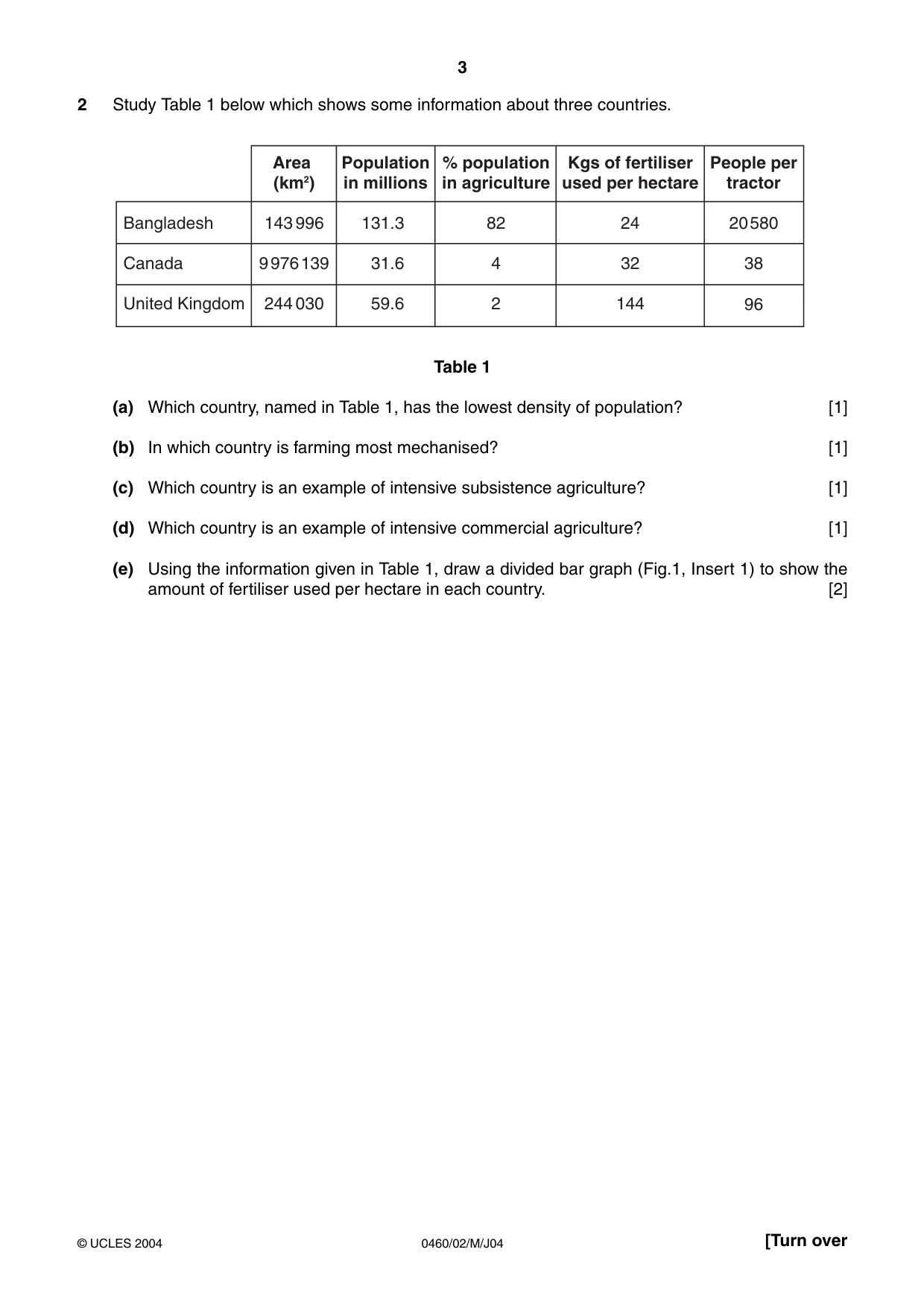
3 0460/02/M/J04 [Turn over 2 Study Table 1 below which shows some information about three countries. Table 1 (a) Which country, named in Table 1, has the lowest density of population? [1] (b) In which country is farming most mechanised? [1] (c) Which country is an example of intensive subsistence agriculture? [1] (d) Which country is an example of intensive commercial agriculture? [1] (e) Using the information given in Table 1, draw a divided bar graph (Fig.1, Insert 1) to show the amount of fertiliser used per hectare in each country. [2] Area (km2) 143996 9976139 244030 Bangladesh Canada United Kingdom Population in millions 131.3 31.6 59.6 % population in agriculture 82 4 2 Kgs of fertiliser used per hectare 24 32 144 People per tractor 20580 38 96 © UCLES 2004
Question paper, page 4
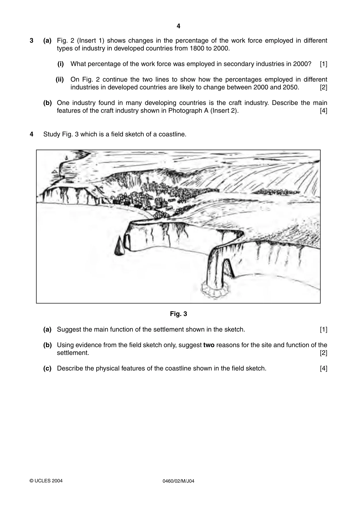
4 0460/02/M/J04 3 (a) Fig. 2 (Insert 1) shows changes in the percentage of the work force employed in different types of industry in developed countries from 1800 to 2000. (i) What percentage of the work force was employed in secondary industries in 2000? [1] (ii) On Fig. 2 continue the two lines to show how the percentages employed in different industries in developed countries are likely to change between 2000 and 2050. [2] (b) One industry found in many developing countries is the craft industry. Describe the main features of the craft industry shown in Photograph A (Insert 2). [4] 4 Study Fig. 3 which is a field sketch of a coastline. Fig. 3 (a) Suggest the main function of the settlement shown in the sketch. [1] (b) Using evidence from the field sketch only, suggest two reasons for the site and function of the settlement. [2] (c) Describe the physical features of the coastline shown in the field sketch. [4] © UCLES 2004
Question paper, page 5
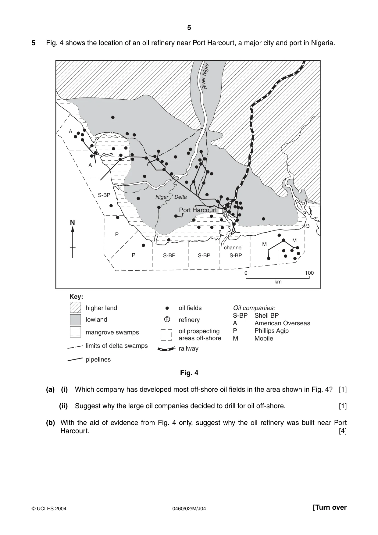
5 0460/02/M/J04 [Turn over 5 Fig. 4 shows the location of an oil refinery near Port Harcourt, a major city and port in Nigeria. Fig. 4 (a) (i) Which company has developed most off-shore oil fields in the area shown in Fig. 4? [1] (ii) Suggest why the large oil companies decided to drill for oil off-shore. [1] (b) With the aid of evidence from Fig. 4 only, suggest why the oil refinery was built near Port Harcourt. [4] A A S-BP S-BP S-BP S-BP channel P P Niger Port Harcourt Delta M M 0 100 km R i v e r Nige r R N Key: R higher land lowland mangrove swamps limits of delta swamps pipelines oil fields Oil companies: S-BP Shell BP A American Overseas P Phillips Agip M Mobile refinery oil prospecting areas off-shore railway © UCLES 2004
Question paper, page 6
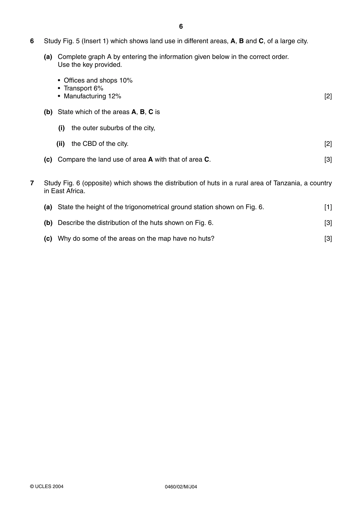
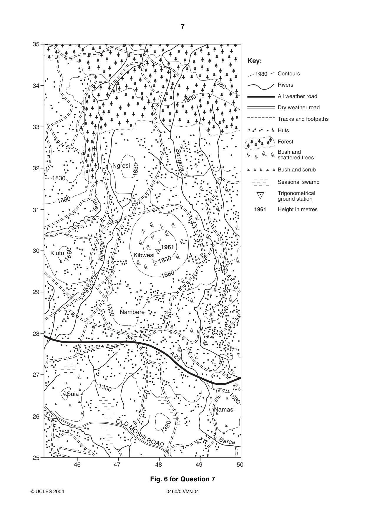
6 0460/02/M/J04 6 Study Fig. 5 (Insert 1) which shows land use in different areas, A, B and C, of a large city. (a) Complete graph A by entering the information given below in the correct order. Use the key provided. • Offices and shops 10% • Transport 6% • Manufacturing 12% [2] (b) State which of the areas A, B, C is (i) the outer suburbs of the city, (ii) the CBD of the city. [2] (c) Compare the land use of area A with that of area C. [3] 7 Study Fig. 6 (opposite) which shows the distribution of huts in a rural area of Tanzania, a country in East Africa. (a) State the height of the trigonometrical ground station shown on Fig. 6. [1] (b) Describe the distribution of the huts shown on Fig. 6. [3] (c) Why do some of the areas on the map have no huts? [3] © UCLES 2004
Question paper, page 7
7 0460/02/M/J04 Fig. 6 for Question 7 O L D M O SH I R OA D Kiutu Suia Nambere Namasi Kibwesi Ngresi 1961 1830 1680 1530 1680 1830 1380 1830 1830 So n got a 1 6 8 0 Kijenge Te m i A23 1380 1 3 8 0 1530 B a raa 1980 35 34 33 32 31 30 29 28 27 26 25 46 47 48 49 50 1980 Key: 1961 Contours Rivers All weather road Dry weather road Tracks and footpaths Huts Forest Bush and scattered trees Bush and scrub Seasonal swamp Trigonometrical ground station Height in metres © UCLES 2004
Question paper, page 8
8 0460/02/M/J04 © UCLES 2004 Copyright Acknowledgements: Question 3 Photograph. R.F. Sharpe University of Cambridge International Examinations has made every effort to trace copyright holders, but if we have inadvertently overlooked any we will be pleased to make the necessary arrangements at the first opportunity. University of Cambridge International Examinations is part of the University of Cambridge Local Examinations Syndicate (UCLES) which is itself a department of the University of Cambridge.