Cambridge IGCSE Pakistan Studies 0448 — 2010 May/June Paper 2 · Variant 1
0448/21/M/J/10 · 75 marks · ≈84 min
The question paper and its mark scheme, free to read here and free to download. This is Cambridge’s own paper, exactly as it was sat.
Question paper8 pages
Mark scheme11 pages
Answers below. Sit the paper first if you are practising.
Paper as text
Question paper, page 1
This document consists of 8 printed pages and 1 insert. DC (NF/CGW) 25022 © UCLES 2010 [Turn over UNIVERSITY OF CAMBRIDGE INTERNATIONAL EXAMINATIONS International General Certificate of Secondary Education READ THESE INSTRUCTIONS FIRST If you have been given an Answer Booklet, follow the instructions on the front cover of the Booklet. Write your Centre number, candidate number and name on all the work you hand in. Write in dark blue or black pen. Do not use staples, paper clips, highlighters, glue or correction fluid. Answer any three questions. Sketch maps and diagrams may be drawn wherever they serve to illustrate an answer. The Insert contains Photograph A for Question 3 and Photograph B for Question 4. At the end of the examination, fasten all your work securely together. Write the number of each question attempted in the grid on the front cover of your Answer Booklet. The number of marks is given in brackets [ ] at the end of each question or part question. * 1 2 4 9 1 3 0 5 4 6 * PAKISTAN STUDIES 0448/02 Paper 2 May/June 2010 1 hour 30 minutes Additional Materials: Answer Booklet/Paper www.XtremePapers.com
Question paper, page 2
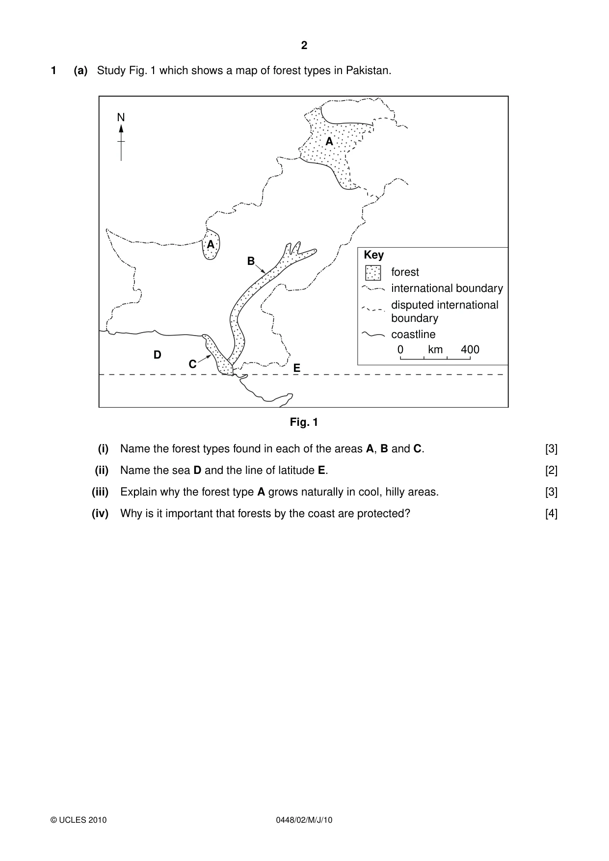
0448/02/M/J/10 © UCLES 2010 2 1 (a) Study Fig. 1 which shows a map of forest types in Pakistan. 0 400 km E D C B A N forest Key international boundary disputed international boundary coastline A Fig. 1 (i) Name the forest types found in each of the areas A, B and C. [3] (ii) Name the sea D and the line of latitude E. [2] (iii) Explain why the forest type A grows naturally in cool, hilly areas. [3] (iv) Why is it important that forests by the coast are protected? [4]
Question paper, page 3
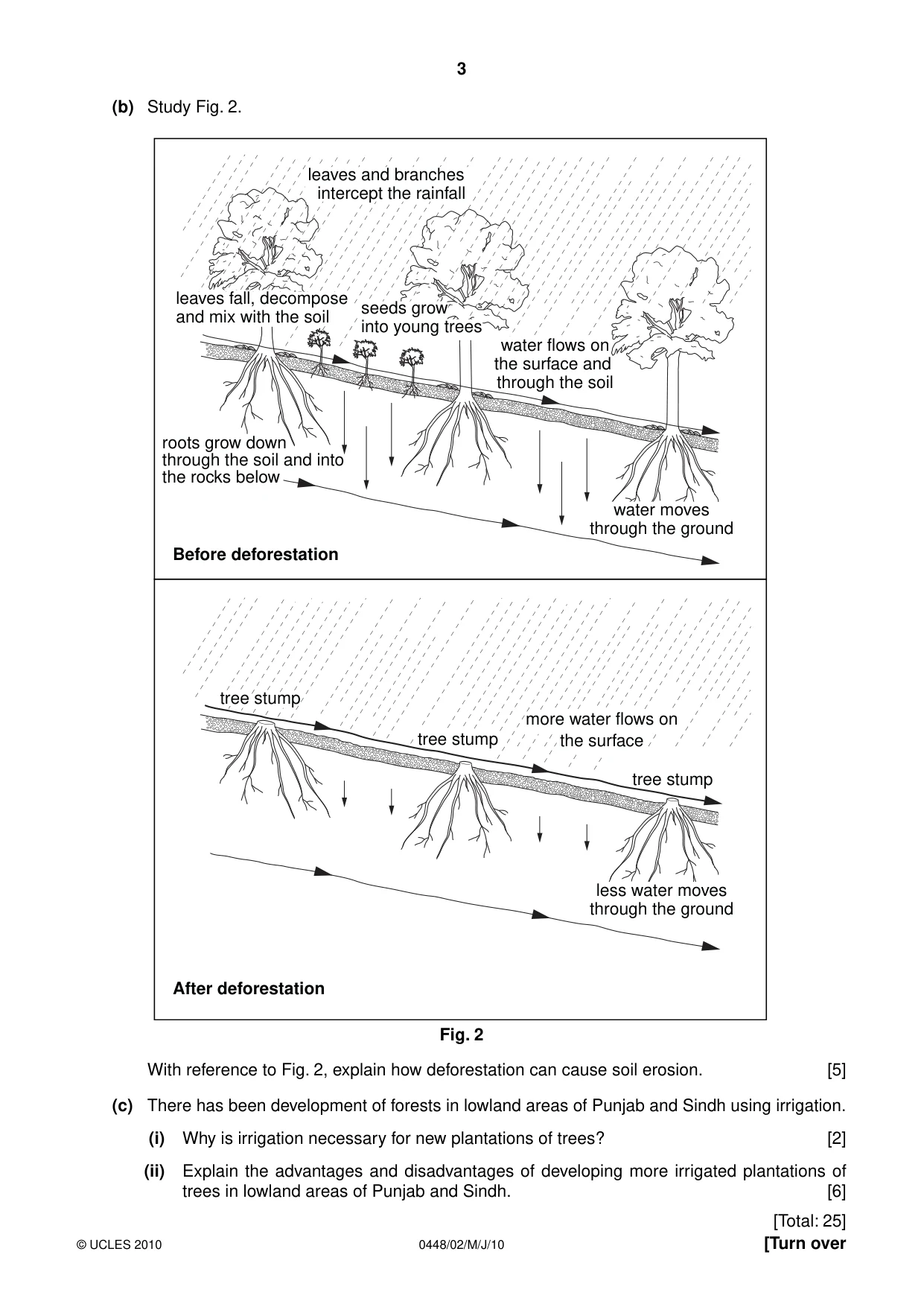
0448/02/M/J/10 © UCLES 2010 [Turn over 3 (b) Study Fig. 2. tree stump tree stump tree stump more water flows on the surface seeds grow into young trees Before deforestation After deforestation water flows on the surface and through the soil leaves fall, decompose and mix with the soil leaves and branches intercept the rainfall water moves through the ground less water moves through the ground roots grow down through the soil and into the rocks below Fig. 2 With reference to Fig. 2, explain how deforestation can cause soil erosion. [5] (c) There has been development of forests in lowland areas of Punjab and Sindh using irrigation. (i) Why is irrigation necessary for new plantations of trees? [2] (ii) Explain the advantages and disadvantages of developing more irrigated plantations of trees in lowland areas of Punjab and Sindh. [6] [Total: 25]
Question paper, page 4
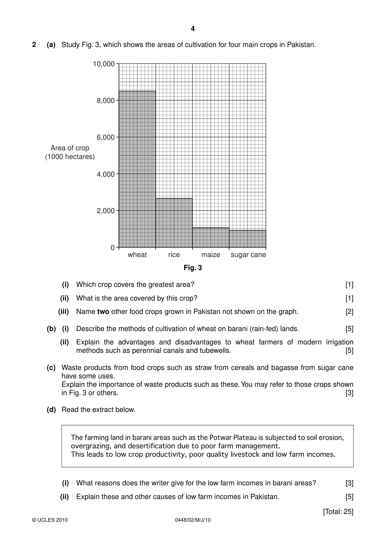
0448/02/M/J/10 © UCLES 2010 4 2 (a) Study Fig. 3, which shows the areas of cultivation for four main crops in Pakistan. 10,000 8,000 6,000 Area of crop (1000 hectares) 4,000 2,000 0 wheat rice maize sugar cane Fig. 3 (i) Which crop covers the greatest area? [1] (ii) What is the area covered by this crop? [1] (iii) Name two other food crops grown in Pakistan not shown on the graph. [2] (b) (i) Describe the methods of cultivation of wheat on barani (rain-fed) lands. [5] (ii) Explain the advantages and disadvantages to wheat farmers of modern irrigation methods such as perennial canals and tubewells. [5] (c) Waste products from food crops such as straw from cereals and bagasse from sugar cane have some uses. Explain the importance of waste products such as these. You may refer to those crops shown in Fig. 3 or others. [3] (d) Read the extract below. The farming land in barani areas such as the Potwar Plateau is subjected to soil erosion, overgrazing, and desertification due to poor farm management. This leads to low crop productivity, poor quality livestock and low farm incomes. (i) What reasons does the writer give for the low farm incomes in barani areas? [3] (ii) Explain these and other causes of low farm incomes in Pakistan. [5] [Total: 25]
Question paper, page 5
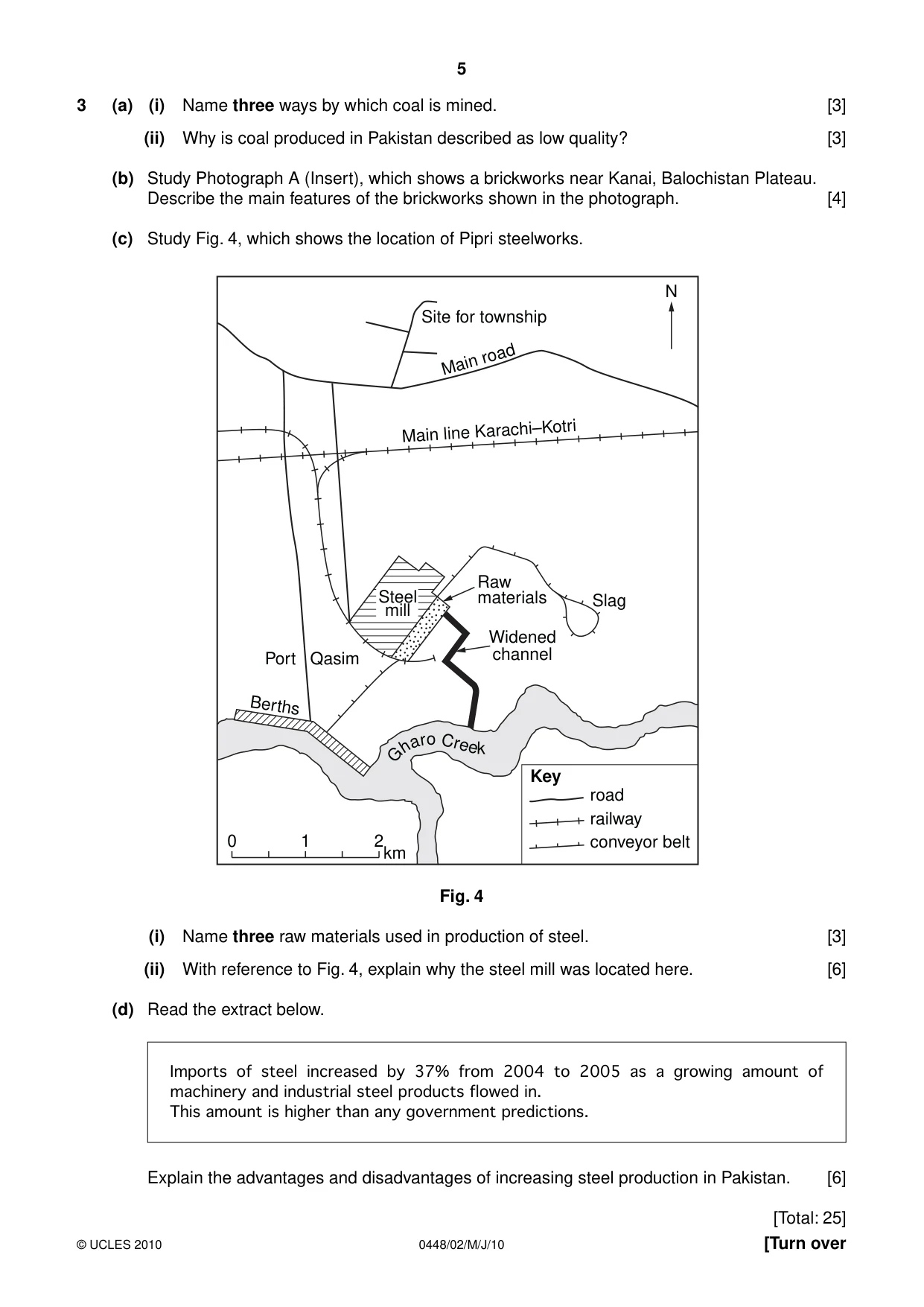
0448/02/M/J/10 © UCLES 2010 [Turn over 5 3 (a) (i) Name three ways by which coal is mined. [3] (ii) Why is coal produced in Pakistan described as low quality? [3] (b) Study Photograph A (Insert), which shows a brickworks near Kanai, Balochistan Plateau. Describe the main features of the brickworks shown in the photograph. [4] (c) Study Fig. 4, which shows the location of Pipri steelworks. N Site for township Main line Karachi–Kotri Main road Steel mill 0 1 2 road Key railway conveyor belt km Port Qasim Slag Widened channel Raw materials Berths G h a r o C ree k Fig. 4 (i) Name three raw materials used in production of steel. [3] (ii) With reference to Fig. 4, explain why the steel mill was located here. [6] (d) Read the extract below. Imports of steel increased by 37% from 2004 to 2005 as a growing amount of machinery and industrial steel products flowed in. This amount is higher than any government predictions. Explain the advantages and disadvantages of increasing steel production in Pakistan. [6] [Total: 25]
Question paper, page 6
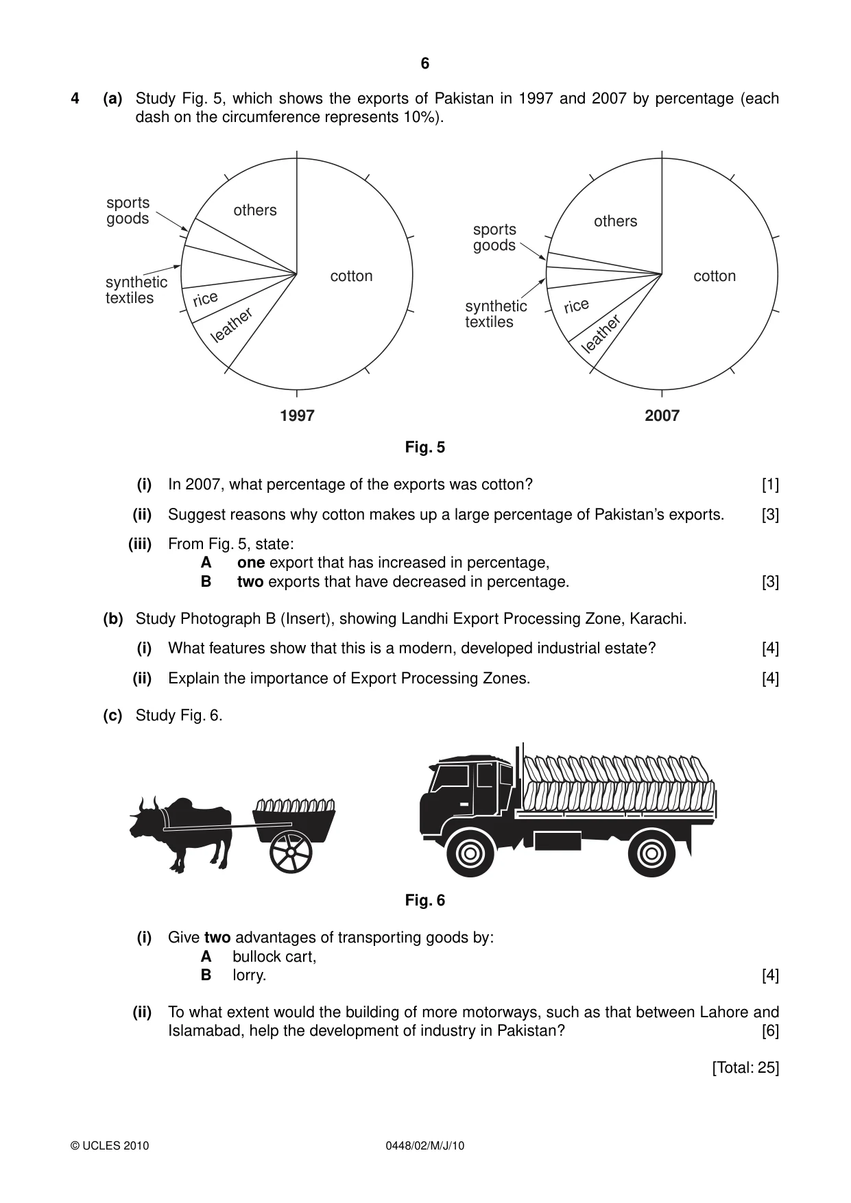
0448/02/M/J/10 © UCLES 2010 6 4 (a) Study Fig. 5, which shows the exports of Pakistan in 1997 and 2007 by percentage (each dash on the circumference represents 10%). cotton others others sports goods sports goods synthetic textiles synthetic textiles rice rice leather leather cotton 1997 2007 Fig. 5 (i) In 2007, what percentage of the exports was cotton? [1] (ii) Suggest reasons why cotton makes up a large percentage of Pakistan’s exports. [3] (iii) From Fig. 5, state: A one export that has increased in percentage, B two exports that have decreased in percentage. [3] (b) Study Photograph B (Insert), showing Landhi Export Processing Zone, Karachi. (i) What features show that this is a modern, developed industrial estate? [4] (ii) Explain the importance of Export Processing Zones. [4] (c) Study Fig. 6. Fig. 6 (i) Give two advantages of transporting goods by: A bullock cart, B lorry. [4] (ii) To what extent would the building of more motorways, such as that between Lahore and Islamabad, help the development of industry in Pakistan? [6] [Total: 25]
Question paper, page 7
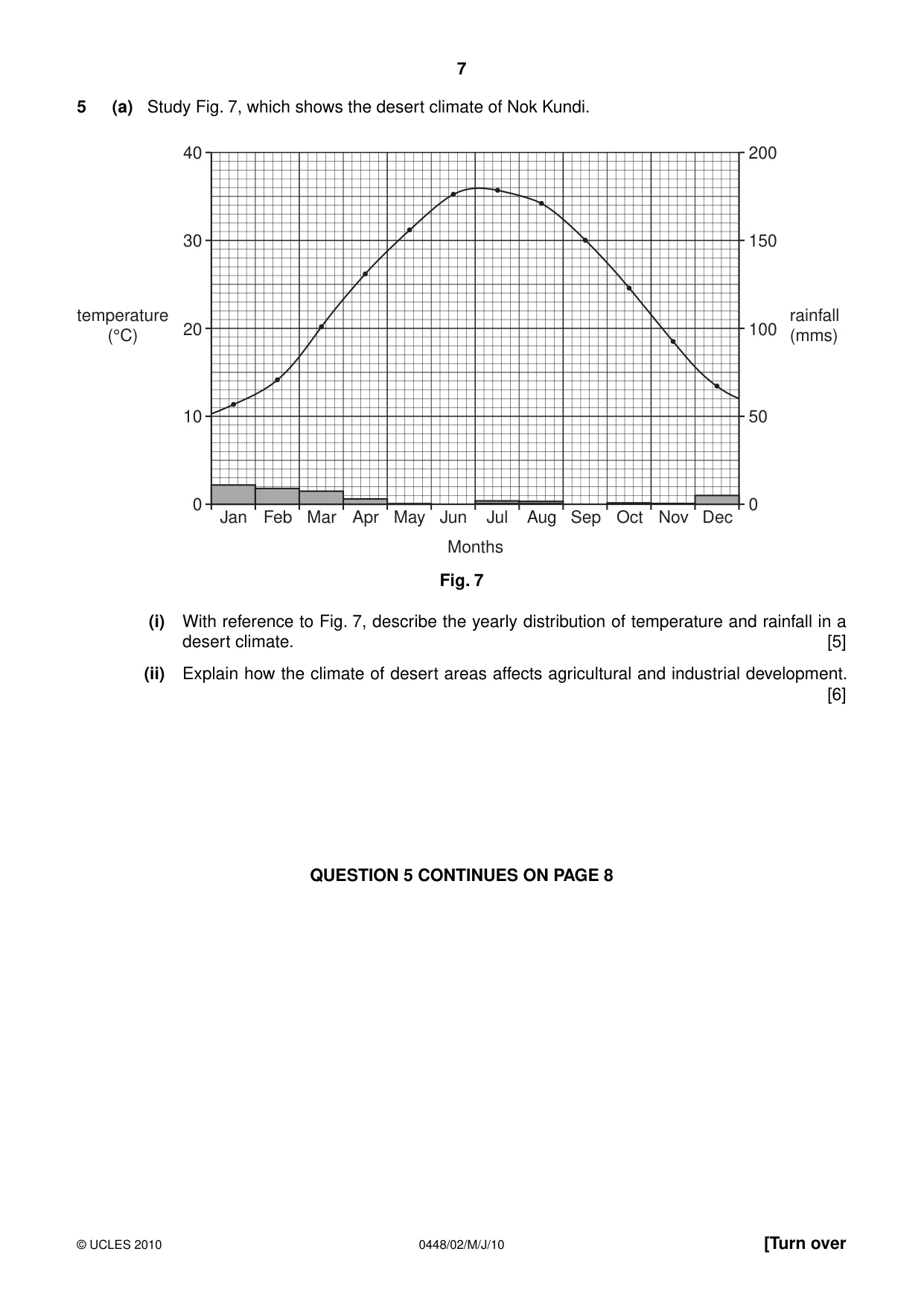
0448/02/M/J/10 © UCLES 2010 [Turn over 7 5 (a) Study Fig. 7, which shows the desert climate of Nok Kundi. Jan 0 10 20 30 40 0 50 100 rainfall (mms) temperature (°C) 150 200 Feb Mar Apr May Jun Jul Months Aug Sep Oct Nov Dec Fig. 7 (i) With reference to Fig. 7, describe the yearly distribution of temperature and rainfall in a desert climate. [5] (ii) Explain how the climate of desert areas affects agricultural and industrial development. [6] QUESTION 5 CONTINUES ON PAGE 8
Question paper, page 8
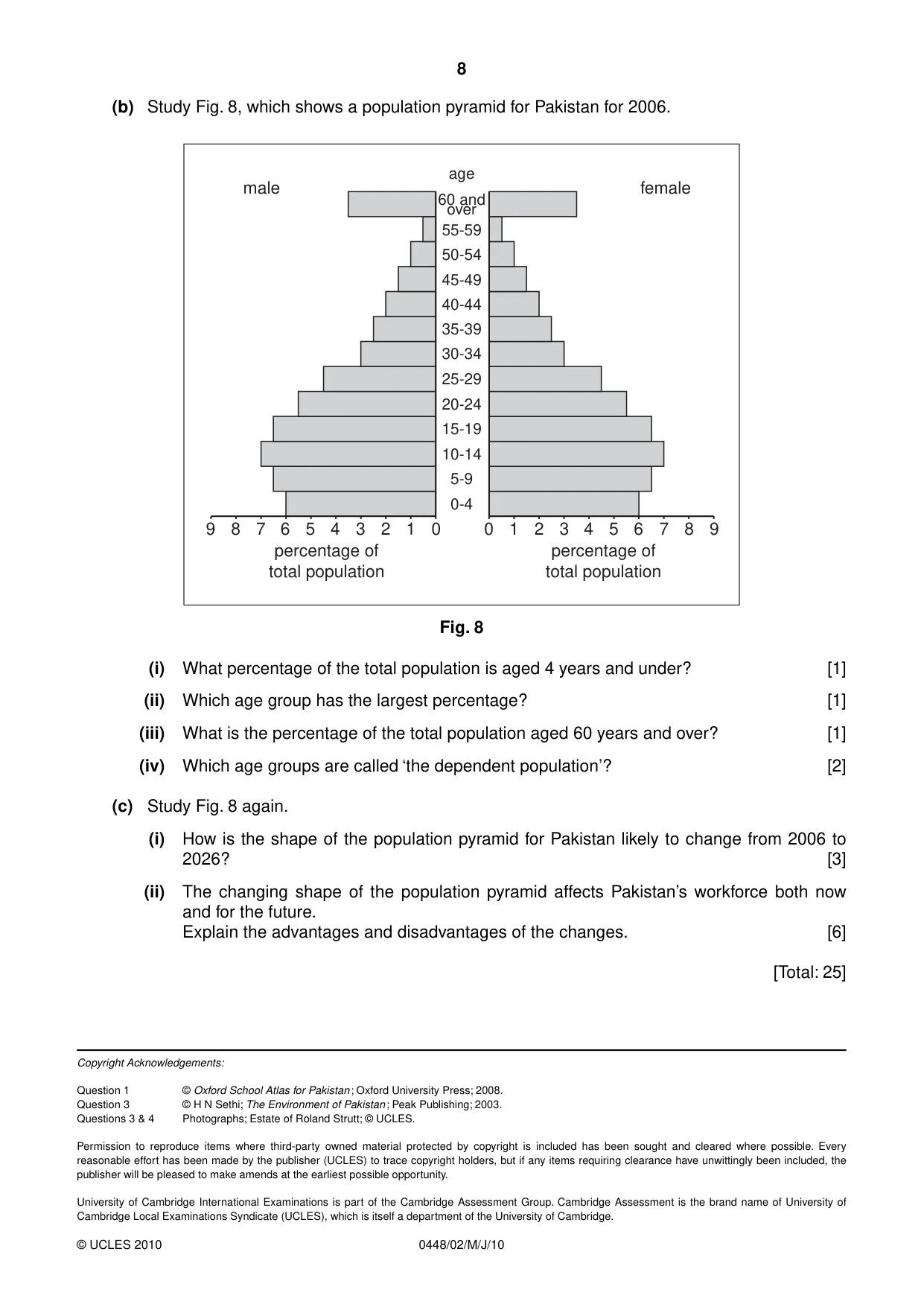
8 0448/02/M/J/10 © UCLES 2010 8 (b) Study Fig. 8, which shows a population pyramid for Pakistan for 2006. 0-4 0 1 2 3 4 5 6 7 8 9 0 9 8 female male 7 6 5 percentage of total population percentage of total population 4 3 2 1 5-9 10-14 15-19 20-24 25-29 30-34 35-39 40-44 45-49 50-54 55-59 60 and over age Fig. 8 (i) What percentage of the total population is aged 4 years and under? [1] (ii) Which age group has the largest percentage? [1] (iii) What is the percentage of the total population aged 60 years and over? [1] (iv) Which age groups are called ‘the dependent population’? [2] (c) Study Fig. 8 again. (i) How is the shape of the population pyramid for Pakistan likely to change from 2006 to 2026? [3] (ii) The changing shape of the population pyramid affects Pakistan’s workforce both now and for the future. Explain the advantages and disadvantages of the changes. [6] [Total: 25] Copyright Acknowledgements: Question 1 © Oxford School Atlas for Pakistan ; Oxford University Press; 2008. Question 3 © H N Sethi; The Environment of Pakistan ; Peak Publishing; 2003. Questions 3 & 4 Photographs; Estate of Roland Strutt; © UCLES. Permission to reproduce items where third-party owned material protected by copyright is included has been sought and cleared where possible. Every reasonable effort has been made by the publisher (UCLES) to trace copyright holders, but if any items requiring clearance have unwittingly been included, the publisher will be pleased to make amends at the earliest possible opportunity. University of Cambridge International Examinations is part of the Cambridge Assessment Group. Cambridge Assessment is the brand name of University of Cambridge Local Examinations Syndicate (UCLES), which is itself a department of the University of Cambridge.
Mark scheme, page 1
UNIVERSITY OF CAMBRIDGE INTERNATIONAL EXAMINATIONS International General Certificate of Secondary Education MARK SCHEME for the May/June 2010 question paper for the guidance of teachers 0448 PAKISTAN STUDIES 0448/02 Paper 2 (Environment of Pakistan), maximum raw mark 75 This mark scheme is published as an aid to teachers and candidates, to indicate the requirements of the examination. It shows the basis on which Examiners were instructed to award marks. It does not indicate the details of the discussions that took place at an Examiners’ meeting before marking began, which would have considered the acceptability of alternative answers. Mark schemes must be read in conjunction with the question papers and the report on the examination. • CIE will not enter into discussions or correspondence in connection with these mark schemes. CIE is publishing the mark schemes for the May/June 2010 question papers for most IGCSE, GCE Advanced Level and Advanced Subsidiary Level syllabuses and some Ordinary Level syllabuses. www.XtremePapers.com
Mark scheme, page 2
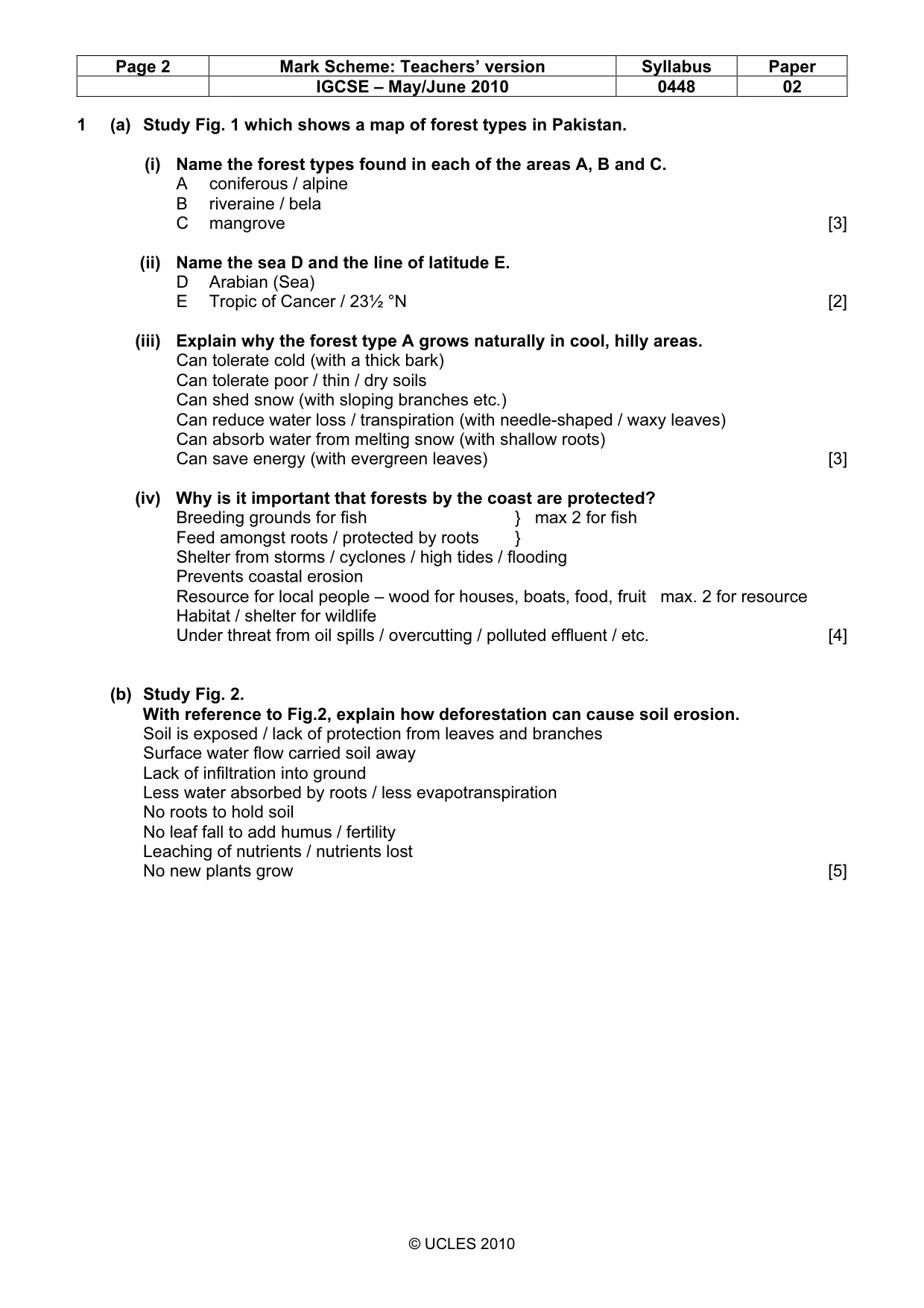
Page 2 Mark Scheme: Teachers’ version Syllabus Paper IGCSE – May/June 2010 0448 02 © UCLES 2010 1 (a) Study Fig. 1 which shows a map of forest types in Pakistan. (i) Name the forest types found in each of the areas A, B and C. A coniferous / alpine B riveraine / bela C mangrove [3] (ii) Name the sea D and the line of latitude E. D Arabian (Sea) E Tropic of Cancer / 23½ °N [2] (iii) Explain why the forest type A grows naturally in cool, hilly areas. Can tolerate cold (with a thick bark) Can tolerate poor / thin / dry soils Can shed snow (with sloping branches etc.) Can reduce water loss / transpiration (with needle-shaped / waxy leaves) Can absorb water from melting snow (with shallow roots) Can save energy (with evergreen leaves) [3] (iv) Why is it important that forests by the coast are protected? Breeding grounds for fish } max 2 for fish Feed amongst roots / protected by roots } Shelter from storms / cyclones / high tides / flooding Prevents coastal erosion Resource for local people – wood for houses, boats, food, fruit max. 2 for resource Habitat / shelter for wildlife Under threat from oil spills / overcutting / polluted effluent / etc. [4] (b) Study Fig. 2. With reference to Fig.2, explain how deforestation can cause soil erosion. Soil is exposed / lack of protection from leaves and branches Surface water flow carried soil away Lack of infiltration into ground Less water absorbed by roots / less evapotranspiration No roots to hold soil No leaf fall to add humus / fertility Leaching of nutrients / nutrients lost No new plants grow [5]
Mark scheme, page 3
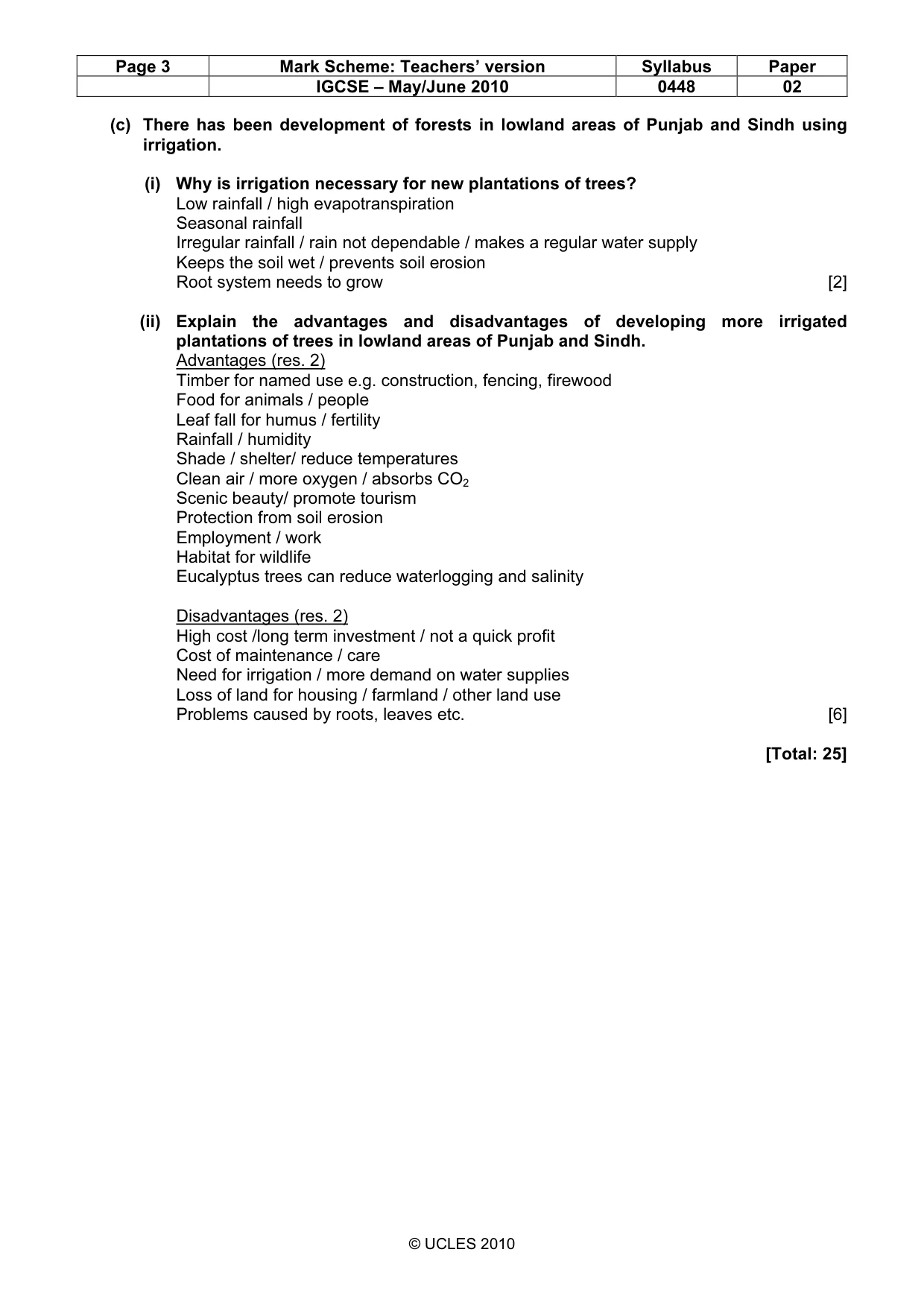
Page 3 Mark Scheme: Teachers’ version Syllabus Paper IGCSE – May/June 2010 0448 02 © UCLES 2010 (c) There has been development of forests in lowland areas of Punjab and Sindh using irrigation. (i) Why is irrigation necessary for new plantations of trees? Low rainfall / high evapotranspiration Seasonal rainfall Irregular rainfall / rain not dependable / makes a regular water supply Keeps the soil wet / prevents soil erosion Root system needs to grow [2] (ii) Explain the advantages and disadvantages of developing more irrigated plantations of trees in lowland areas of Punjab and Sindh. Advantages (res. 2) Timber for named use e.g. construction, fencing, firewood Food for animals / people Leaf fall for humus / fertility Rainfall / humidity Shade / shelter/ reduce temperatures Clean air / more oxygen / absorbs CO2 Scenic beauty/ promote tourism Protection from soil erosion Employment / work Habitat for wildlife Eucalyptus trees can reduce waterlogging and salinity Disadvantages (res. 2) High cost /long term investment / not a quick profit Cost of maintenance / care Need for irrigation / more demand on water supplies Loss of land for housing / farmland / other land use Problems caused by roots, leaves etc. [6] [Total: 25]
Mark scheme, page 4
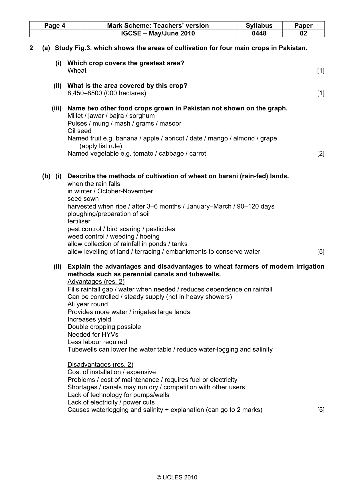
Page 4 Mark Scheme: Teachers’ version Syllabus Paper IGCSE – May/June 2010 0448 02 © UCLES 2010 2 (a) Study Fig.3, which shows the areas of cultivation for four main crops in Pakistan. (i) Which crop covers the greatest area? Wheat [1] (ii) What is the area covered by this crop? 8,450–8500 (000 hectares) [1] (iii) Name two other food crops grown in Pakistan not shown on the graph. Millet / jawar / bajra / sorghum Pulses / mung / mash / grams / masoor Oil seed Named fruit e.g. banana / apple / apricot / date / mango / almond / grape (apply list rule) Named vegetable e.g. tomato / cabbage / carrot [2] (b) (i) Describe the methods of cultivation of wheat on barani (rain-fed) lands. when the rain falls in winter / October-November seed sown harvested when ripe / after 3–6 months / January–March / 90–120 days ploughing/preparation of soil fertiliser pest control / bird scaring / pesticides weed control / weeding / hoeing allow collection of rainfall in ponds / tanks allow levelling of land / terracing / embankments to conserve water [5] (ii) Explain the advantages and disadvantages to wheat farmers of modern irrigation methods such as perennial canals and tubewells. Advantages (res. 2) Fills rainfall gap / water when needed / reduces dependence on rainfall Can be controlled / steady supply (not in heavy showers) All year round Provides more water / irrigates large lands Increases yield Double cropping possible Needed for HYVs Less labour required Tubewells can lower the water table / reduce water-logging and salinity Disadvantages (res. 2) Cost of installation / expensive Problems / cost of maintenance / requires fuel or electricity Shortages / canals may run dry / competition with other users Lack of technology for pumps/wells Lack of electricity / power cuts Causes waterlogging and salinity + explanation (can go to 2 marks) [5]
Mark scheme, page 5
Page 5 Mark Scheme: Teachers’ version Syllabus Paper IGCSE – May/June 2010 0448 02 © UCLES 2010 (c) Waste products from food crops such as straw from cereals and bagasse from sugar cane have some uses. Explain the importance of waste products such as these. You may refer to those crops shown in Fig. 3 or others. bagasse for paper / cardboard / packaging bagasse for chipboard, molasses / bagasse for chemical industry straw for bedding / roofing / strawboard animal food composted mixed into soil / ploughed in bagasse for power stations / fuel The candidate may refer to ‘importance’ if so accept Can save fossil fuels / coal / gas / oil Cheaper than fossil fuels etc. / electricity Etc. [3] (d) Read the extract below. The farming land in barani areas such as the Potwar Plateau is subjected to soil erosion, overgrazing, and desertification due to poor farm management. This leads to low crop productivity, poor quality livestock and low farm incomes. (i) What reasons does the writer give for the low farm incomes in barani areas? soil erosion, over grazing, desertification [3] (ii) Explain these, and other causes of low farm incomes. Explanation of those reasons stated in (i). This may include those given in the last sentence of the extract. E.g. Soil erosion means poor root growth and small crop output Overgrazing means lack of food for animals and soil erosion / desertification Desertification causes climatic change and a lack of water Low crop productivity means low incomes leading to less money for better seed, fertiliser etc. Poor quality livestock produces less milk, meat etc. Little money to spend on better seed, fertiliser etc. because of low farm incomes Also candidates may be given marks for explaining Traditional farming methods give low yields Small farms so little mechanisation Oppressive landlords (Zamindari) so high rents, no chance of improvement Poor climate so difficult to grow good crops Storms and flooding / pest attacks (e.g. locusts, weevils) destroy crops Illiteracy / lack of education so no improvements Rural – urban migration so able-bodied men leave Waterlogging and salinity reduces cultivable area / yield Lack of government support / investment [5] [Total: 25]
Mark scheme, page 6
Page 6 Mark Scheme: Teachers’ version Syllabus Paper IGCSE – May/June 2010 0448 02 © UCLES 2010 3 (a) (i) Name three ways by which coal is mined. Shaft, adit / drift, open cast [3] (ii) Why is coal produced in Pakistan described as low quality? Lignite Low burning temperature / produces less energy Low carbon content / more impurities / more smoke High ash content High sulphur content [3] (b) Study Photograph A (Insert 1), which shows a brickworks near Kanai, Balochistan Plateau. Describe the main features of the brickworks shown in the photograph. Furnace / Kilns Chimney(s) Black smoke / pollution Air intakes below ground Hard /flat working area Piles of finished bricks Pattern of small hummocks Good / Pucca road / tarred road / highway Electricity pylon/ Telephone poles / lines Moulds Underground entrance [4] (c) Study Fig. 4, which shows the location of Pipri steelworks. (i) Name three raw materials used in production of steel. Coal/coke Iron ore / scrap iron Manganese Limestone, Oxygen / air Chromite [3] (ii) With reference to Fig. 4, explain why the steel mills were located here. coastal site/ Port (Bin) Qasim for imports berths by creek for unloading widened channel for effluent / shipping railway /road – for supply of limestone / workers – for distribution of finished products township / houses for workers large /open site for waste disposal, storage, building etc. [6]
Mark scheme, page 7
Page 7 Mark Scheme: Teachers’ version Syllabus Paper IGCSE – May/June 2010 0448 02 © UCLES 2010 (d) Read the extract below. Imports of steel increased by 37% from 2004 to 2005 as a growing amount of machinery and industrial steel products flowed in. This is more than any government predictions. Explain the advantages and disadvantages of increasing steel production in Pakistan. Advantages (res. 2) Cheaper supplies (than imports) Saves foreign currency / improves balance of payments / reduce imports Can be used for development / industrialisation e.g. construction, machinery (max 2 examples of use) Larger GNP / GDP / national income Independence from other countries More work / employment Disadvantages Lack of raw materials/imported High cost of imported iron / other raw materials Burden on economy / less development Cost / Lack of machinery / technology / set-up costs Cost / Lack of infrastructure / power supplies / roads etc. Lack of skilled labour More waste / named pollution (max 2.) May encourage rural-urban migration Accept ‘increases balance of payments’ if opposite not given in advantages [6] [Total: 25]
Mark scheme, page 8
Page 8 Mark Scheme: Teachers’ version Syllabus Paper IGCSE – May/June 2010 0448 02 © UCLES 2010 4 (a) Study Fig. 5, which shows the exports of Pakistan in 2007 by percentage. (i) What percentage of the exports was cotton? 60 (%) [1] (ii) Suggest reasons why cotton makes up a large percentage of Pakistan’s exports. Produces a surplus of raw cotton / large production Large international demand / Cannot be grown in other countries/Europe Cheap labour/ competitive price Can be a variety of products [3] Many textile mills / factories (iii) From Fig. 5 state A one item that has increased in its percentage, rice B two items that have decreased in their percentage. [3] Leather, synthetic textiles, sports goods (b) Study Photograph B (Insert 1), showing Landhi Export Processing Zone, Karachi. (i) What features show that this is a modern, developed industrial estate? Good / pucca / metalled / wide Street lighting Electricity supply Trees/ greenery Modern / good quality buildings Planned / straight roads [4] (ii) Explain the importance of Export Processing Zones. Good quality goods / export quality / to International standards Can increase economy / income / exports / foreign exchange Better infrastructure / power / water supply / road etc. (max. 2) Good working conditions (max 2) Modern buildings Incentives e.g. tax breaks, cheap loans Attracts investors / entrepreneurs Aids growth of small-scale / cottage industries Employment / jobs Government helps with marketing events / trade fairs [4]
Mark scheme, page 9
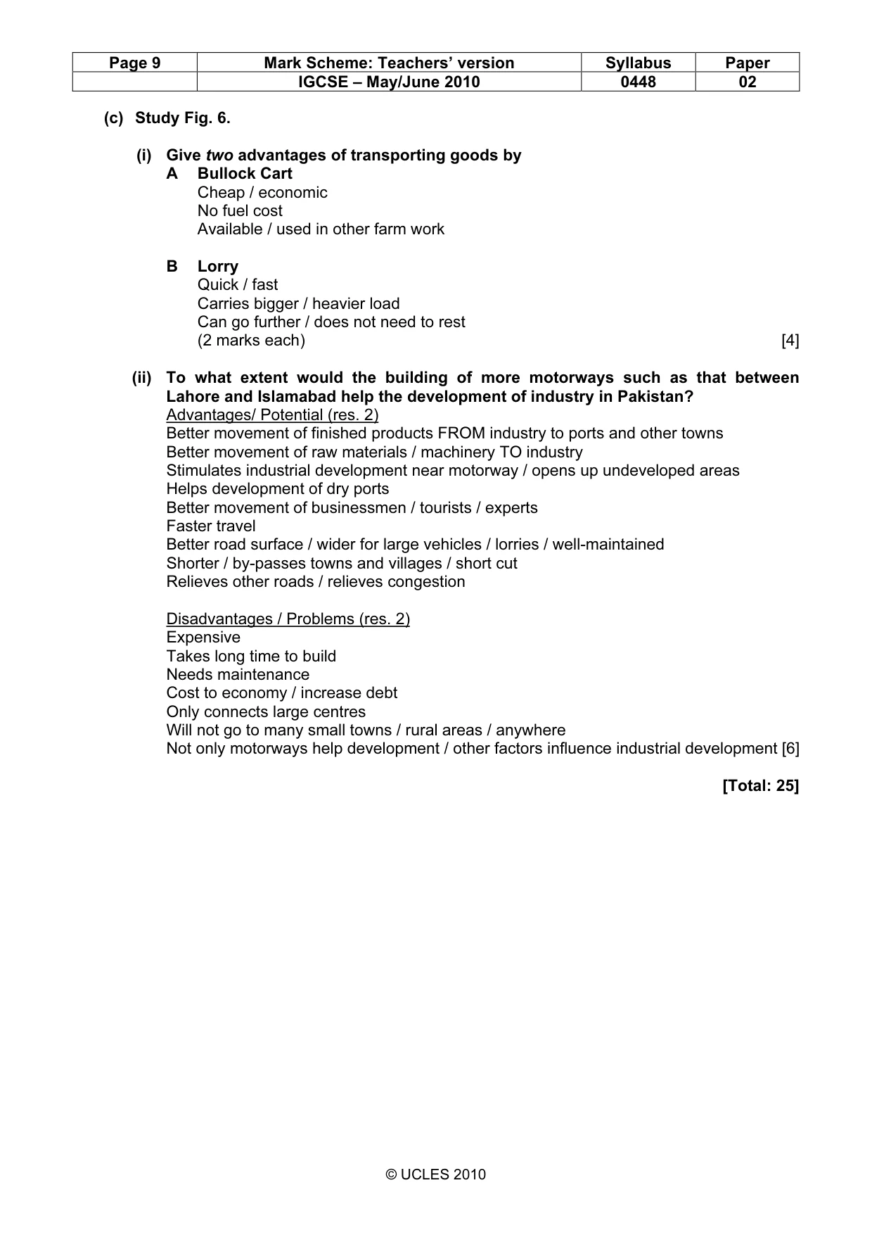
Page 9 Mark Scheme: Teachers’ version Syllabus Paper IGCSE – May/June 2010 0448 02 © UCLES 2010 (c) Study Fig. 6. (i) Give two advantages of transporting goods by A Bullock Cart Cheap / economic No fuel cost Available / used in other farm work B Lorry Quick / fast Carries bigger / heavier load Can go further / does not need to rest (2 marks each) [4] (ii) To what extent would the building of more motorways such as that between Lahore and Islamabad help the development of industry in Pakistan? Advantages/ Potential (res. 2) Better movement of finished products FROM industry to ports and other towns Better movement of raw materials / machinery TO industry Stimulates industrial development near motorway / opens up undeveloped areas Helps development of dry ports Better movement of businessmen / tourists / experts Faster travel Better road surface / wider for large vehicles / lorries / well-maintained Shorter / by-passes towns and villages / short cut Relieves other roads / relieves congestion Disadvantages / Problems (res. 2) Expensive Takes long time to build Needs maintenance Cost to economy / increase debt Only connects large centres Will not go to many small towns / rural areas / anywhere Not only motorways help development / other factors influence industrial development [6] [Total: 25]
Mark scheme, page 10
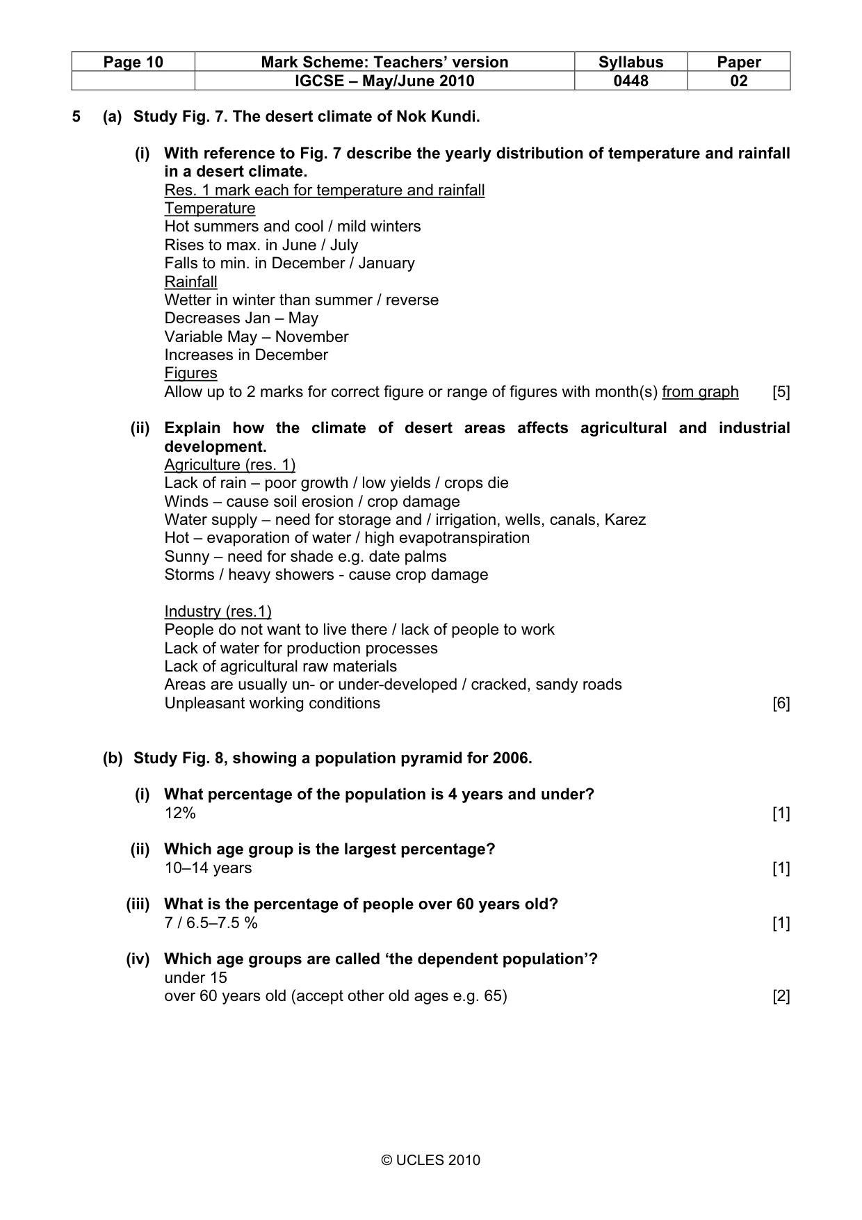
Page 10 Mark Scheme: Teachers’ version Syllabus Paper IGCSE – May/June 2010 0448 02 © UCLES 2010 5 (a) Study Fig. 7. The desert climate of Nok Kundi. (i) With reference to Fig. 7 describe the yearly distribution of temperature and rainfall in a desert climate. Res. 1 mark each for temperature and rainfall Temperature Hot summers and cool / mild winters Rises to max. in June / July Falls to min. in December / January Rainfall Wetter in winter than summer / reverse Decreases Jan – May Variable May – November Increases in December Figures Allow up to 2 marks for correct figure or range of figures with month(s) from graph [5] (ii) Explain how the climate of desert areas affects agricultural and industrial development. Agriculture (res. 1) Lack of rain – poor growth / low yields / crops die Winds – cause soil erosion / crop damage Water supply – need for storage and / irrigation, wells, canals, Karez Hot – evaporation of water / high evapotranspiration Sunny – need for shade e.g. date palms Storms / heavy showers - cause crop damage Industry (res.1) People do not want to live there / lack of people to work Lack of water for production processes Lack of agricultural raw materials Areas are usually un- or under-developed / cracked, sandy roads Unpleasant working conditions [6] (b) Study Fig. 8, showing a population pyramid for 2006. (i) What percentage of the population is 4 years and under? 12% [1] (ii) Which age group is the largest percentage? 10–14 years [1] (iii) What is the percentage of people over 60 years old? 7 / 6.5–7.5 % [1] (iv) Which age groups are called ‘the dependent population’? under 15 over 60 years old (accept other old ages e.g. 65) [2]
Mark scheme, page 11
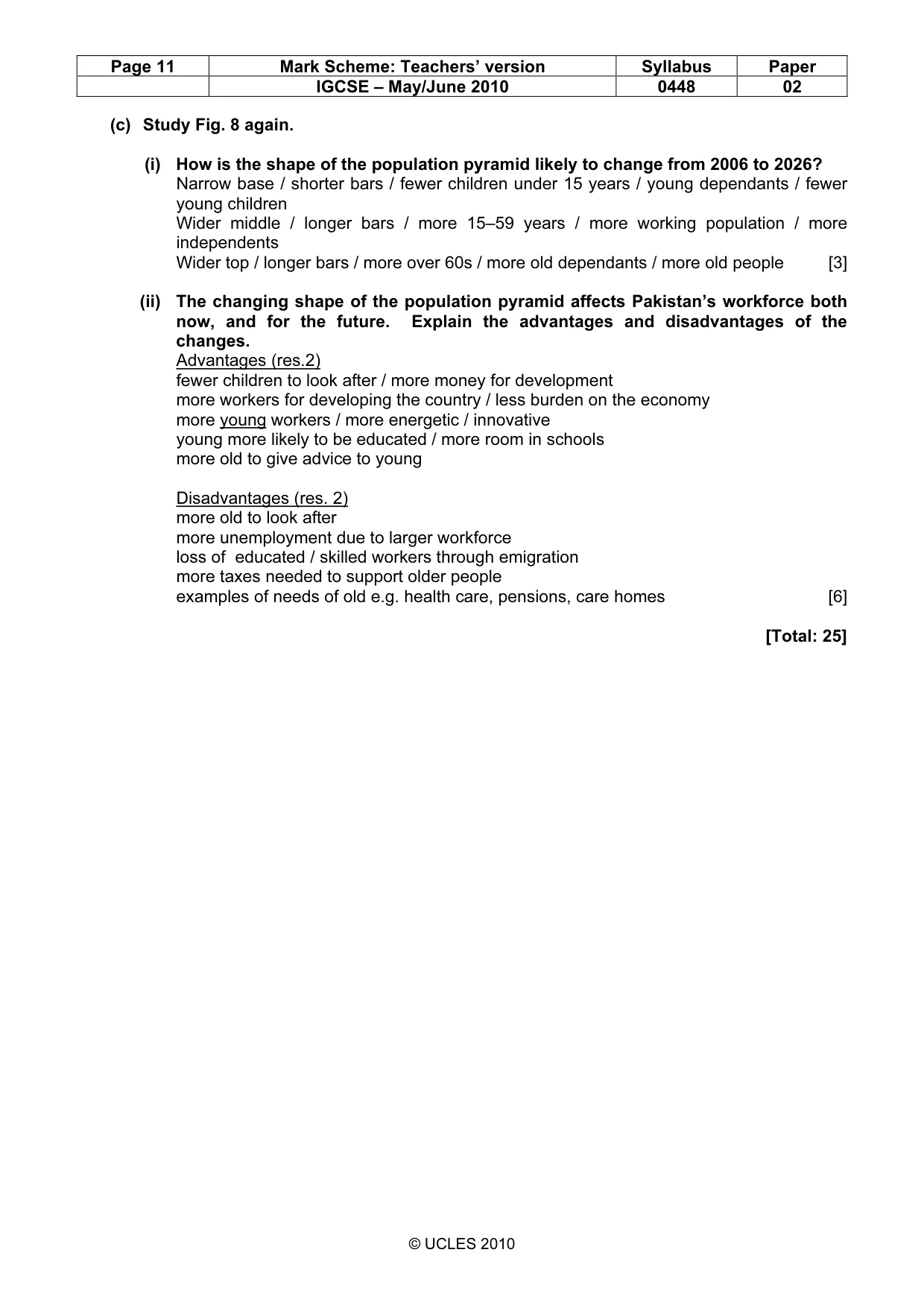
Page 11 Mark Scheme: Teachers’ version Syllabus Paper IGCSE – May/June 2010 0448 02 © UCLES 2010 (c) Study Fig. 8 again. (i) How is the shape of the population pyramid likely to change from 2006 to 2026? Narrow base / shorter bars / fewer children under 15 years / young dependants / fewer young children Wider middle / longer bars / more 15–59 years / more working population / more independents Wider top / longer bars / more over 60s / more old dependants / more old people [3] (ii) The changing shape of the population pyramid affects Pakistan’s workforce both now, and for the future. Explain the advantages and disadvantages of the changes. Advantages (res.2) fewer children to look after / more money for development more workers for developing the country / less burden on the economy more young workers / more energetic / innovative young more likely to be educated / more room in schools more old to give advice to young Disadvantages (res. 2) more old to look after more unemployment due to larger workforce loss of educated / skilled workers through emigration more taxes needed to support older people examples of needs of old e.g. health care, pensions, care homes [6] [Total: 25]
What you needed in this session
Cambridge’s own grade thresholds for 2010 May/June, Paper 2 · Variant 1. A higher threshold means an easier paper — the bar moves with how the cohort did.