Cambridge IGCSE Pakistan Studies 0448 — 2008 May/June Paper 2 · Variant 1
0448/21/M/J/08 · 75 marks · ≈84 min
The question paper and its mark scheme, free to read here and free to download. This is Cambridge’s own paper, exactly as it was sat.
Question paper8 pages

Mark scheme8 pages
Answers below. Sit the paper first if you are practising.
Paper as text
Question paper, page 1
This document consists of 7 printed pages, 1 blank page and 1 insert. SP (NF/CGW) T48776/4 © UCLES 2008 [Turn over UNIVERSITY OF CAMBRIDGE INTERNATIONAL EXAMINATIONS General Certificate of Education Ordinary Level International General Certificate of Secondary Education READ THESE INSTRUCTIONS FIRST If you have been given an Answer Booklet, follow the instructions on the front cover of the Booklet. Write your Centre number, candidate number and name on all the work you hand in. Write in dark blue or black pen. Do not use staples, paper clips, highlighters, glue or correction fluid. Answer any three questions. Sketch maps and diagrams may be drawn whenever they serve to illustrate an answer. The Insert contains Photograph A for Question 1. At the end of the examination, fasten all your work securely together. Write the number of each question attempted in the grid on the front cover of your Answer Booklet. The number of marks is given in brackets [ ] at the end of each question or part question. * 6 8 2 9 9 7 1 9 3 6 * PAKISTAN STUDIES 0448/02 2059/02 Paper 2 May/June 2008 1 hour 30 minutes Additional Materials: Answer Booklet/Paper www.XtremePapers.com
Question paper, page 2
2 2059/02/M/J/08 © UCLES 2008 The Environment of Pakistan 1 (a) Study Photograph A (Insert) showing sugar cane cultivation. (i) Describe the scene. [4] (ii) What are the advantages and disadvantages of using tractors instead of animals for work on a farm? [6] (b) Yields from crops vary from year to year. Explain the reasons for this. [4] (c) (i) What work is done on the farm by these animals, other than that shown in the photograph? [3] (ii) What do these animals and other livestock on the farm produce that the farmer can use or sell? [3] (d) How can livestock farming be improved in Pakistan? [5]
Question paper, page 3
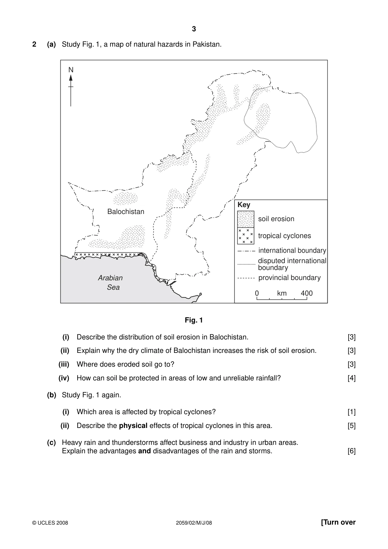
3 2059/02/M/J/08 © UCLES 2008 [Turn over 2 (a) Study Fig. 1, a map of natural hazards in Pakistan. Balochistan Key soil erosion tropical cyclones international boundary disputed international boundary N Arabian Sea provincial boundary 0 400 km Fig. 1 (i) Describe the distribution of soil erosion in Balochistan. [3] (ii) Explain why the dry climate of Balochistan increases the risk of soil erosion. [3] (iii) Where does eroded soil go to? [3] (iv) How can soil be protected in areas of low and unreliable rainfall? [4] (b) Study Fig. 1 again. (i) Which area is affected by tropical cyclones? [1] (ii) Describe the physical effects of tropical cyclones in this area. [5] (c) Heavy rain and thunderstorms affect business and industry in urban areas. Explain the advantages and disadvantages of the rain and storms. [6]
Question paper, page 4
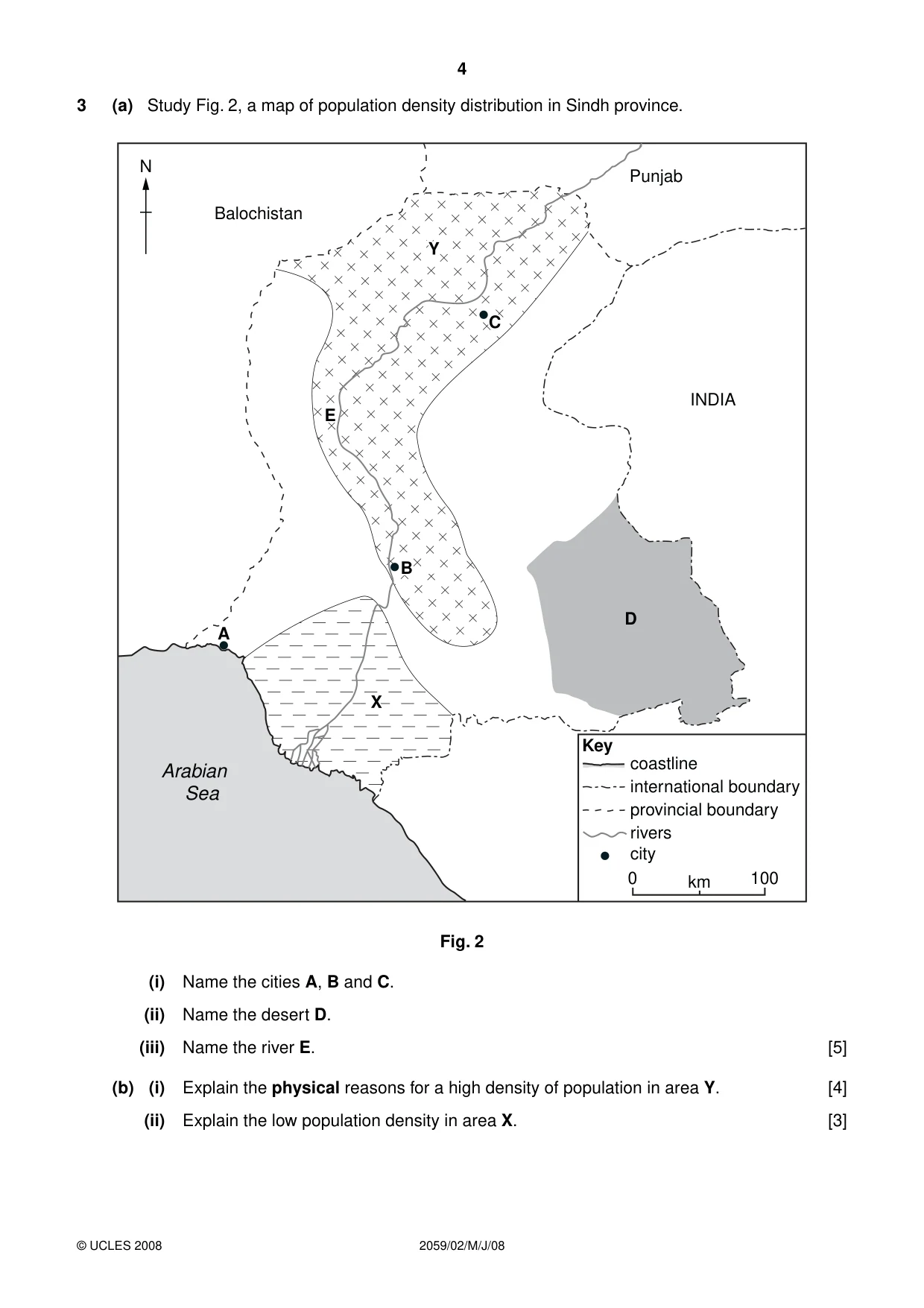
4 2059/02/M/J/08 © UCLES 2008 3 (a) Study Fig. 2, a map of population density distribution in Sindh province. Arabian Sea A B B E C Y X D E Balochistan N Punjab INDIA coastline Key international boundary provincial boundary rivers city 0 100 km Fig. 2 (i) Name the cities A, B and C. (ii) Name the desert D. (iii) Name the river E. [5] (b) (i) Explain the physical reasons for a high density of population in area Y. [4] (ii) Explain the low population density in area X. [3]
Question paper, page 5
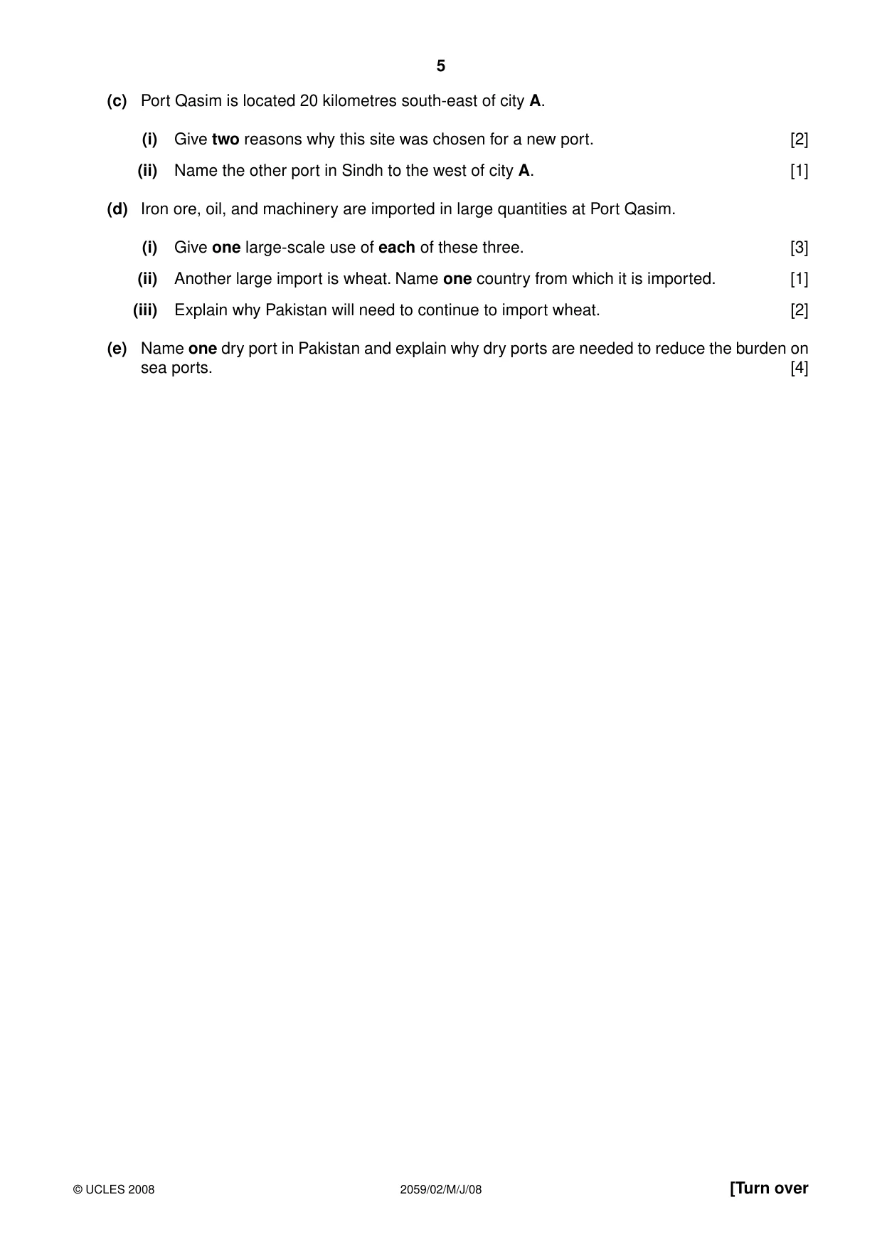
5 2059/02/M/J/08 © UCLES 2008 [Turn over (c) Port Qasim is located 20 kilometres south-east of city A. (i) Give two reasons why this site was chosen for a new port. [2] (ii) Name the other port in Sindh to the west of city A. [1] (d) Iron ore, oil, and machinery are imported in large quantities at Port Qasim. (i) Give one large-scale use of each of these three. [3] (ii) Another large import is wheat. Name one country from which it is imported. [1] (iii) Explain why Pakistan will need to continue to import wheat. [2] (e) Name one dry port in Pakistan and explain why dry ports are needed to reduce the burden on sea ports. [4]
Question paper, page 6
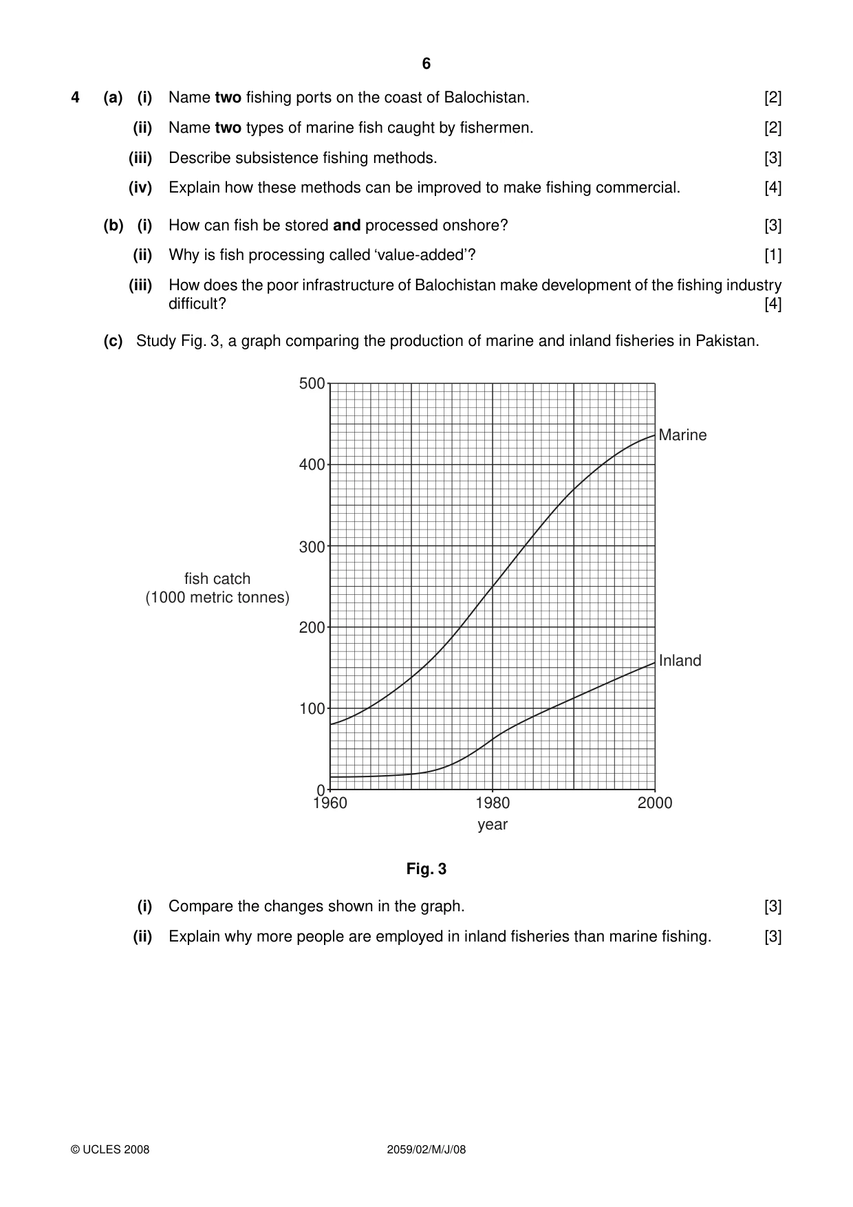
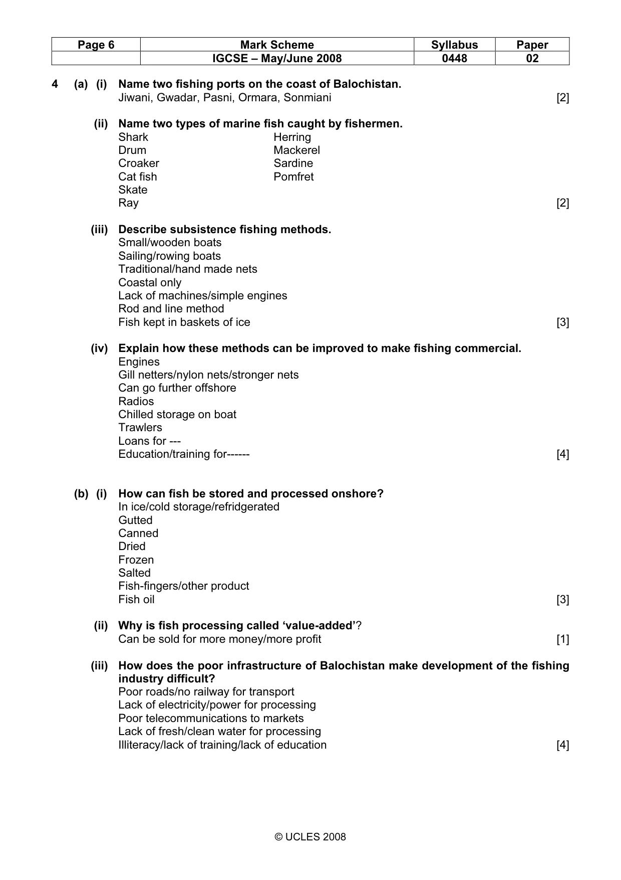
6 2059/02/M/J/08 © UCLES 2008 4 (a) (i) Name two fishing ports on the coast of Balochistan. [2] (ii) Name two types of marine fish caught by fishermen. [2] (iii) Describe subsistence fishing methods. [3] (iv) Explain how these methods can be improved to make fishing commercial. [4] (b) (i) How can fish be stored and processed onshore? [3] (ii) Why is fish processing called ‘value-added’? [1] (iii) How does the poor infrastructure of Balochistan make development of the fishing industry difficult? [4] (c) Study Fig. 3, a graph comparing the production of marine and inland fisheries in Pakistan. 500 400 300 200 100 0 1960 1980 year fish catch (1000 metric tonnes) 2000 Inland Marine Fig. 3 (i) Compare the changes shown in the graph. [3] (ii) Explain why more people are employed in inland fisheries than marine fishing. [3]
Question paper, page 7
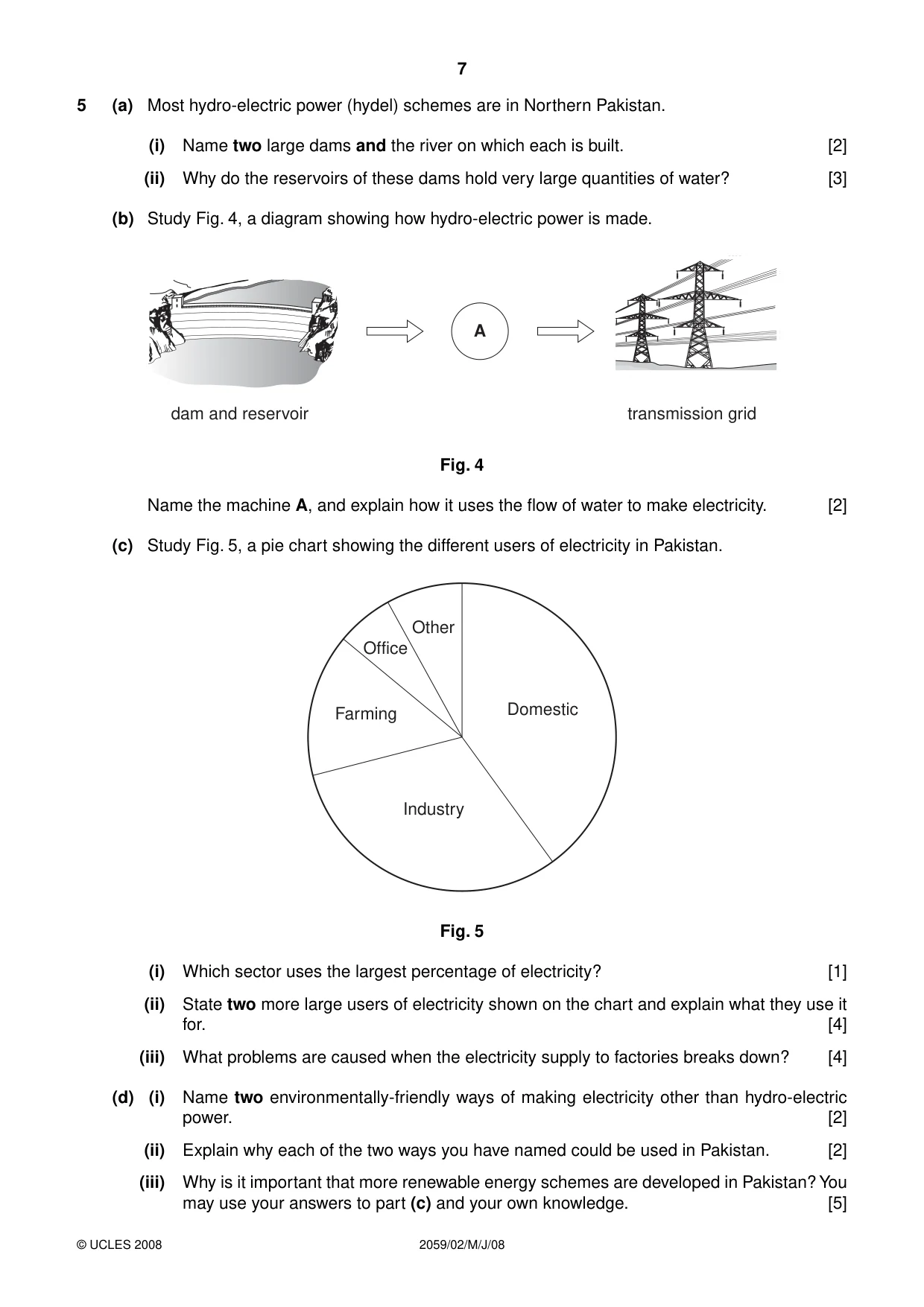
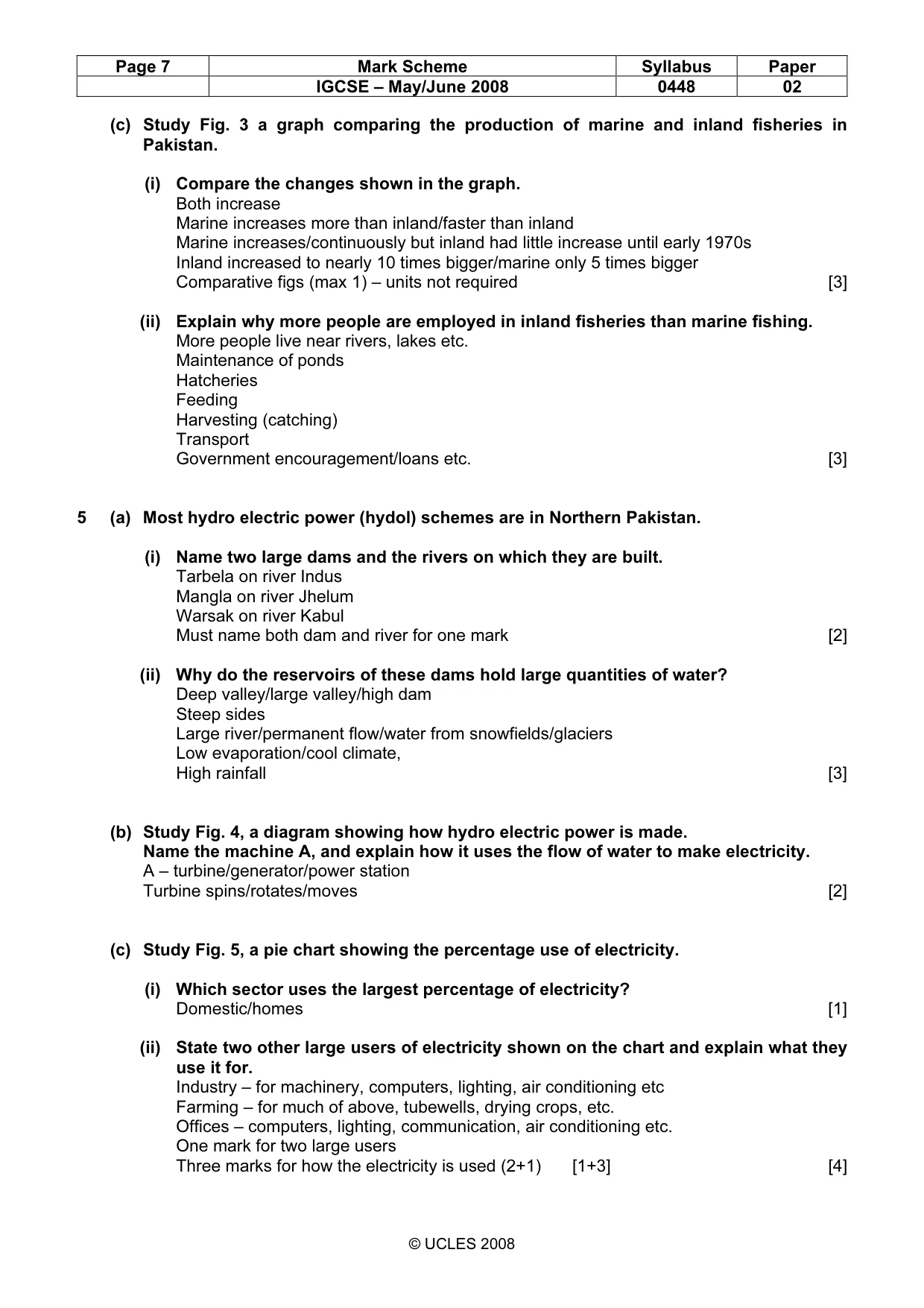
7 2059/02/M/J/08 © UCLES 2008 5 (a) Most hydro-electric power (hydel) schemes are in Northern Pakistan. (i) Name two large dams and the river on which each is built. [2] (ii) Why do the reservoirs of these dams hold very large quantities of water? [3] (b) Study Fig. 4, a diagram showing how hydro-electric power is made. A dam and reservoir transmission grid Fig. 4 Name the machine A, and explain how it uses the flow of water to make electricity. [2] (c) Study Fig. 5, a pie chart showing the different users of electricity in Pakistan. Domestic Industry Farming Other Office Fig. 5 (i) Which sector uses the largest percentage of electricity? [1] (ii) State two more large users of electricity shown on the chart and explain what they use it for. [4] (iii) What problems are caused when the electricity supply to factories breaks down? [4] (d) (i) Name two environmentally-friendly ways of making electricity other than hydro-electric power. [2] (ii) Explain why each of the two ways you have named could be used in Pakistan. [2] (iii) Why is it important that more renewable energy schemes are developed in Pakistan? You may use your answers to part (c) and your own knowledge. [5]
Question paper, page 8
8 2059/02/M/J/08 BLANK PAGE Copyright Acknowledgements: Question 1 Photograph A © Estate of Roland Strutt. Permission to reproduce items where third-party owned material protected by copyright is included has been sought and cleared where possible. Every reasonable effort has been made by the publisher (UCLES) to trace copyright holders, but if any items requiring clearance have unwittingly been included, the publisher will be pleased to make amends at the earliest possible opportunity. University of Cambridge International Examinations is part of the Cambridge Assessment Group. Cambridge Assessment is the brand name of University of Cambridge Local Examinations Syndicate (UCLES), which is itself a department of the University of Cambridge.
Mark scheme, page 1
UNIVERSITY OF CAMBRIDGE INTERNATIONAL EXAMINATIONS International General Certificate of Secondary Education MARK SCHEME for the May/June 2008 question paper 0448 PAKISTAN STUDIES 0448/02 Paper 2 (Environment of Pakistan), maximum raw mark 75 This mark scheme is published as an aid to teachers and candidates, to indicate the requirements of the examination. It shows the basis on which Examiners were instructed to award marks. It does not indicate the details of the discussions that took place at an Examiners’ meeting before marking began. All Examiners are instructed that alternative correct answers and unexpected approaches in candidates’ scripts must be given marks that fairly reflect the relevant knowledge and skills demonstrated. Mark schemes must be read in conjunction with the question papers and the report on the examination. • CIE will not enter into discussions or correspondence in connection with these mark schemes. CIE is publishing the mark schemes for the May/June 2008 question papers for most IGCSE, GCE Advanced Level and Advanced Subsidiary Level syllabuses and some Ordinary Level syllabuses. www.XtremePapers.com
Mark scheme, page 2
Page 2 Mark Scheme Syllabus Paper IGCSE – May/June 2008 0448 02 © UCLES 2008 1 (a) Study the Photograph A, showing sugar cane cultivation. (i) Describe the scene. bullocks/cattle/buffalo/ox/cow traditional/manual labour/man/farmer wooden plough/ploughing young/small plants ratoons flat dry soil uncut crop in background trees in background [4] (ii) What are the advantages and disadvantages of using tractors instead of animals for work on a farm? Advantages (res.2) Faster/quicker/suitable for larger fields More efficient/modern/less hard work/do not tire Needs fewer workers Saves animal feed/land/cost of animals Disadvantages (res.2) Expensive to buy/few available to buy/imported } Cost of fuel } max. 2 costs Cost of repair/difficult to repair } Breakdowns Unemployment Needs skilled labour Compact the ground No milk/meat/food etc. No dung for fertiliser Maintainance/repair facilities may not be locally available Cannot use in mountains/fragmented farms [6] (b) Yields from crops vary from year to year. Explain the reasons for this. Lack of rain } Timing/ variability of rain } max.2 climate Flooding } Wind } Problems of irrigation/shortage of water/silt in canals/reservoirs/mechanical failure Build up of salt and waterlogging Pests and diseases (max 2) Family problems/sickness/men go to city Reference to better inputs must relate to previous year’s profit [4] (c) (i) What work is done on the farm by these animals, other than that shown on the photograph? Hoeing – to remove weeds, thin seedlings Harvesting – cutting the crop Milling/grinding/threshing – to remove husks, for flour, by animal walking round Transport – of seeds, fertiliser, crop, to field, to market, Drawing water – from wells, by shaduf, charsa, by walking round Threshing – separating the husk from the seed [3]
Mark scheme, page 3
Page 3 Mark Scheme Syllabus Paper IGCSE – May/June 2008 0448 02 © UCLES 2008 (ii) What do these animals and other livestock on the farm produce that the farmer can use or sell? Dairy products/milk/butter/ghee etc. Meat Hides/skin Young stock Eggs Dung Hooves Horns Bones [3] (d) How can livestock farming be improved in Pakistan? Capital/investment/loans/subsidies for – named purpose Selective/cross breeding, breeding on scientific lines – for better animals etc. Better feed/fodder – for stronger, bigger, animals etc. More grazing land – by irrigation, drainage, fertiliser etc. Control of disease – e.g. Research – disease, breeding, feed etc. Vaccination – to improve health More medicines/more vets to treat animals Education/training in named modern methods Better hygiene/care/living conditions etc. Mechanisation e.g. milking machines for hygiene, speed [5] 2 (a) Study Fig.1, a map of natural hazards in Pakistan. (i) Describe the distribution of soil erosion in Balochistan. Scattered/widespread/in mountains Especially in SW Line at base of highlands Named mountain range/hills/plateau e.g. Central Makram Range, Coastal Range, Chagai Hills Provincial borders [3] (ii) Explain why the dry climate of Balochistan increases the risk of soil erosion. Lack of vegetation/bare soil Slow to re-grow Over cultivation Dry soil less cohesive Wind blows soil away [3] (iii) Where does eroded soil go to? Wind blown into dunes/on foothils Into rivers/canals/ditches/sea Reservoirs/dams/lakes [3] (iv) How can soil be protected in areas of low and unreliable rainfall? Shelter belts/trees/afforestation Irrigation of trees Prevent over-grazing/move livestock/fewer livestock Fill gullies/improved cultivation Terraces and stone lines/reduce gradient Contour ploughing Strip farming [4]
Mark scheme, page 4
Page 4 Mark Scheme Syllabus Paper IGCSE – May/June 2008 0448 02 © UCLES 2008 (b) Study Fig. 1 again. (i) Which area is affected by tropical cyclones? Coast/sindh coast, Balochistan coast Named area e.g. Indus delta, Makram coast [1] (ii) Describe the physical effects of tropical cyclones in this area. High winds High waves Heavy/high rainfall Floods Thunderstorms/thunder/lightening Damage (max.3) but buildings max 1, roads and railways max 1 [5] (c) Heavy rain and thunderstorms affect business and industry in urban areas. Explain the advantages and disadvantages of the rain and storms. Advantages (res.2) Water supply Reservoirs filled for HEP/power supply Disadvantages (res.2) Floods – damage and blockage of roads High winds – damage to buildings, trees Erosion of land – effect on roads/railways/runways Loss of power supply – loss of production, business Danger of lightening Loss of raw material e.g. cotton, sugar cane Disruption of fishing/shipping/trade No flights for businessmen [6] 3 (a) Study Fig. 2 a map of population density distribution in Sindh province. (i) Name the cities A, B and C. A – Karachi B – Hyderabad, C – Sukkur, (ii) Name the desert D. NB. NOT THAL Thar(parkar) (iii) Name the river E. Indus [5] (b) (i) Explain the physical reasons for a higher density of population in area Y. NB. NOT ‘GOOD CLIMATE’ alluvial/rich/fertile soil for good agriculture well drained soil for good agriculture, travel, building etc flat land for use of machinery, travel/building/irrigation etc. water available for irrigation, domestic use, industry etc. (max 2 uses from any line) [4]
Mark scheme, page 5
Page 5 Mark Scheme Syllabus Paper IGCSE – May/June 2008 0448 02 © UCLES 2008 (ii) Explain the low population density in area X. Delta/Indus delta Salt water/saline soil – difficult to farm/poor soil Low river flow/lack of fresh/clean water – so unsuitable for farming, domestic use Flooding – so causes problems to farming, industry Swamp/marsh – difficult to build/poor foundations Mangrove trees – so lack of farmland Tropical storms/typhoons/cyclones – dangerous Lack of roads – so difficult to move around Lack of other named infrastructure – so no industry, improved living standards Dry climate/lack of rain so no agriculture, industry, sanitation Fishing in decline due to pollution/mangroves dying Lack of industry therefore no jobs [3] (c) Port Qasim is located 20 kilometers south-east of city A. (i) Give two reasons why this site was chosen for a new port. Deep water Sheltered harbour/creeks/inlets Close to Karachi/relieve pressure on Karachi Port Near steelworks/Pakistan Steel Mill Flat land Space for industrial development Near oil refinery [2] (ii) Name the other port in Sindh to the west of city A. Keamari/Karachi Port [1] (d) Iron ore, oil, and machinery are imported in large quantities at Port Qasim. (i) Give one large-scale use of each of these three. Iron ore – to Pakistan Steel at Korangi, steel, named iron or steel product Oil – transport, power, electricity, chemicals, etc. Machinery – vehicles, named industry, power generators etc. [3] (ii) Another large import is wheat. Name one country from which it is imported. UK, USA, Russia/Australia [1] (iii) Explain why Pakistan will need to continue to import wheat. Increasing population Poor agricultural production/smaller area cultivated/increase slower than population [2] (e) Name one dry port and explain why dry ports are needed to reduce the burden on sea ports. Sambrai(Sialkot), Lahore Multan, Faisalabad, Rawalpindi, Hyderabad, Larkana, Peshawar, Quetta Reasons: lack of space/storage to deal with paperwork/quicker processing and clearing/customs duties/tax etc. relieve congestion only 2/3 sea ports/few sea ports allows packing/unpacking (of containers) (1+3) [4]
Mark scheme, page 6
Page 6 Mark Scheme Syllabus Paper IGCSE – May/June 2008 0448 02 © UCLES 2008 4 (a) (i) Name two fishing ports on the coast of Balochistan. Jiwani, Gwadar, Pasni, Ormara, Sonmiani [2] (ii) Name two types of marine fish caught by fishermen. Shark Herring Drum Mackerel Croaker Sardine Cat fish Pomfret Skate Ray [2] (iii) Describe subsistence fishing methods. Small/wooden boats Sailing/rowing boats Traditional/hand made nets Coastal only Lack of machines/simple engines Rod and line method Fish kept in baskets of ice [3] (iv) Explain how these methods can be improved to make fishing commercial. Engines Gill netters/nylon nets/stronger nets Can go further offshore Radios Chilled storage on boat Trawlers Loans for --- Education/training for------ [4] (b) (i) How can fish be stored and processed onshore? In ice/cold storage/refridgerated Gutted Canned Dried Frozen Salted Fish-fingers/other product Fish oil [3] (ii) Why is fish processing called ‘value-added’? Can be sold for more money/more profit [1] (iii) How does the poor infrastructure of Balochistan make development of the fishing industry difficult? Poor roads/no railway for transport Lack of electricity/power for processing Poor telecommunications to markets Lack of fresh/clean water for processing Illiteracy/lack of training/lack of education [4]
Mark scheme, page 7
Page 7 Mark Scheme Syllabus Paper IGCSE – May/June 2008 0448 02 © UCLES 2008 (c) Study Fig. 3 a graph comparing the production of marine and inland fisheries in Pakistan. (i) Compare the changes shown in the graph. Both increase Marine increases more than inland/faster than inland Marine increases/continuously but inland had little increase until early 1970s Inland increased to nearly 10 times bigger/marine only 5 times bigger Comparative figs (max 1) – units not required [3] (ii) Explain why more people are employed in inland fisheries than marine fishing. More people live near rivers, lakes etc. Maintenance of ponds Hatcheries Feeding Harvesting (catching) Transport Government encouragement/loans etc. [3] 5 (a) Most hydro electric power (hydol) schemes are in Northern Pakistan. (i) Name two large dams and the rivers on which they are built. Tarbela on river Indus Mangla on river Jhelum Warsak on river Kabul Must name both dam and river for one mark [2] (ii) Why do the reservoirs of these dams hold large quantities of water? Deep valley/large valley/high dam Steep sides Large river/permanent flow/water from snowfields/glaciers Low evaporation/cool climate, High rainfall [3] (b) Study Fig. 4, a diagram showing how hydro electric power is made. Name the machine A, and explain how it uses the flow of water to make electricity. A – turbine/generator/power station Turbine spins/rotates/moves [2] (c) Study Fig. 5, a pie chart showing the percentage use of electricity. (i) Which sector uses the largest percentage of electricity? Domestic/homes [1] (ii) State two other large users of electricity shown on the chart and explain what they use it for. Industry – for machinery, computers, lighting, air conditioning etc Farming – for much of above, tubewells, drying crops, etc. Offices – computers, lighting, communication, air conditioning etc. One mark for two large users Three marks for how the electricity is used (2+1) [1+3] [4]
Mark scheme, page 8
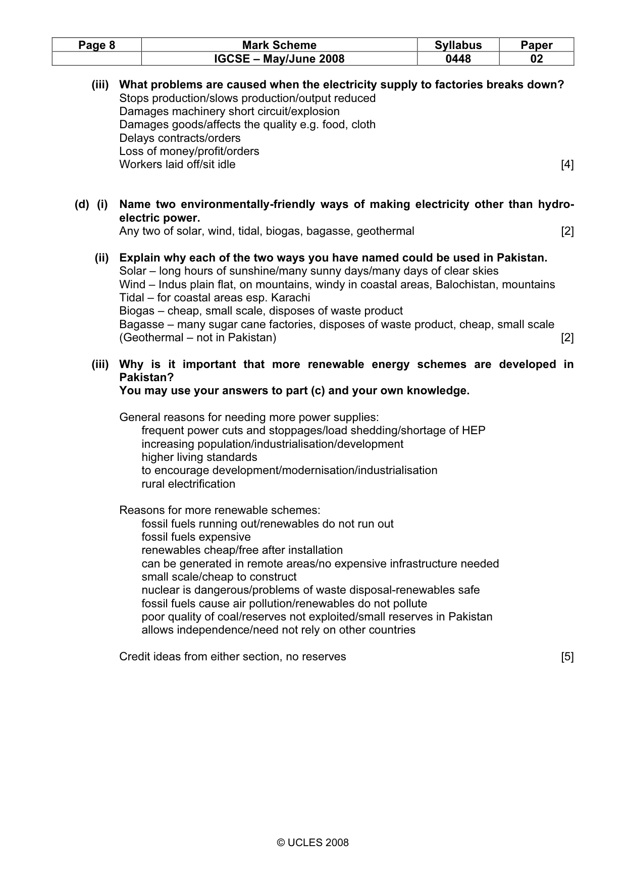
Page 8 Mark Scheme Syllabus Paper IGCSE – May/June 2008 0448 02 © UCLES 2008 (iii) What problems are caused when the electricity supply to factories breaks down? Stops production/slows production/output reduced Damages machinery short circuit/explosion Damages goods/affects the quality e.g. food, cloth Delays contracts/orders Loss of money/profit/orders Workers laid off/sit idle [4] (d) (i) Name two environmentally-friendly ways of making electricity other than hydro- electric power. Any two of solar, wind, tidal, biogas, bagasse, geothermal [2] (ii) Explain why each of the two ways you have named could be used in Pakistan. Solar – long hours of sunshine/many sunny days/many days of clear skies Wind – Indus plain flat, on mountains, windy in coastal areas, Balochistan, mountains Tidal – for coastal areas esp. Karachi Biogas – cheap, small scale, disposes of waste product Bagasse – many sugar cane factories, disposes of waste product, cheap, small scale (Geothermal – not in Pakistan) [2] (iii) Why is it important that more renewable energy schemes are developed in Pakistan? You may use your answers to part (c) and your own knowledge. General reasons for needing more power supplies: frequent power cuts and stoppages/load shedding/shortage of HEP increasing population/industrialisation/development higher living standards to encourage development/modernisation/industrialisation rural electrification Reasons for more renewable schemes: fossil fuels running out/renewables do not run out fossil fuels expensive renewables cheap/free after installation can be generated in remote areas/no expensive infrastructure needed small scale/cheap to construct nuclear is dangerous/problems of waste disposal-renewables safe fossil fuels cause air pollution/renewables do not pollute poor quality of coal/reserves not exploited/small reserves in Pakistan allows independence/need not rely on other countries Credit ideas from either section, no reserves [5]
What you needed in this session
Cambridge’s own grade thresholds for 2008 May/June, Paper 2 · Variant 1. A higher threshold means an easier paper — the bar moves with how the cohort did.