Cambridge IGCSE Geography 0460 — 2020 May/June Paper 1 · Variant 1
0460/11/M/J/20
The question paper and its mark scheme, free to read here and free to download. This is Cambridge’s own paper, exactly as it was sat.
Question paper32 pages










Mark scheme14 pages
Answers below. Sit the paper first if you are practising.
Paper as text
Question paper, page 1
Cambridge IGCSE™ DC (KS/SG) 180131/7 © UCLES 2020 [Turn over This document has 32 pages. Blank pages are indicated. GEOGRAPHY 0460/11 Paper 1 Geographical Themes May/June 2020 1 hour 45 minutes You must answer on the question paper. You will need: Insert (enclosed) Calculator Ruler INSTRUCTIONS ● Answer three questions in total, one from each section. ● Use a black or dark blue pen. You may use an HB pencil for any diagrams or graphs. ● Write your name, centre number and candidate number in the boxes at the top of the page. ● Write your answer to each question in the space provided. ● Do not use an erasable pen or correction fluid. ● Do not write on any bar codes. ● If additional space is needed, you should use the lined pages at the end of this booklet; the question number or numbers must be clearly shown. INFORMATION ● The total mark for this paper is 75. ● The number of marks for each question or part question is shown in brackets [ ]. ● The insert contains additional resources referred to in the questions. Definitions MEDCs – More Economically Developed Countries LEDCs – Less Economically Developed Countries * 7 4 4 1 2 4 6 8 6 7 *
Question paper, page 2
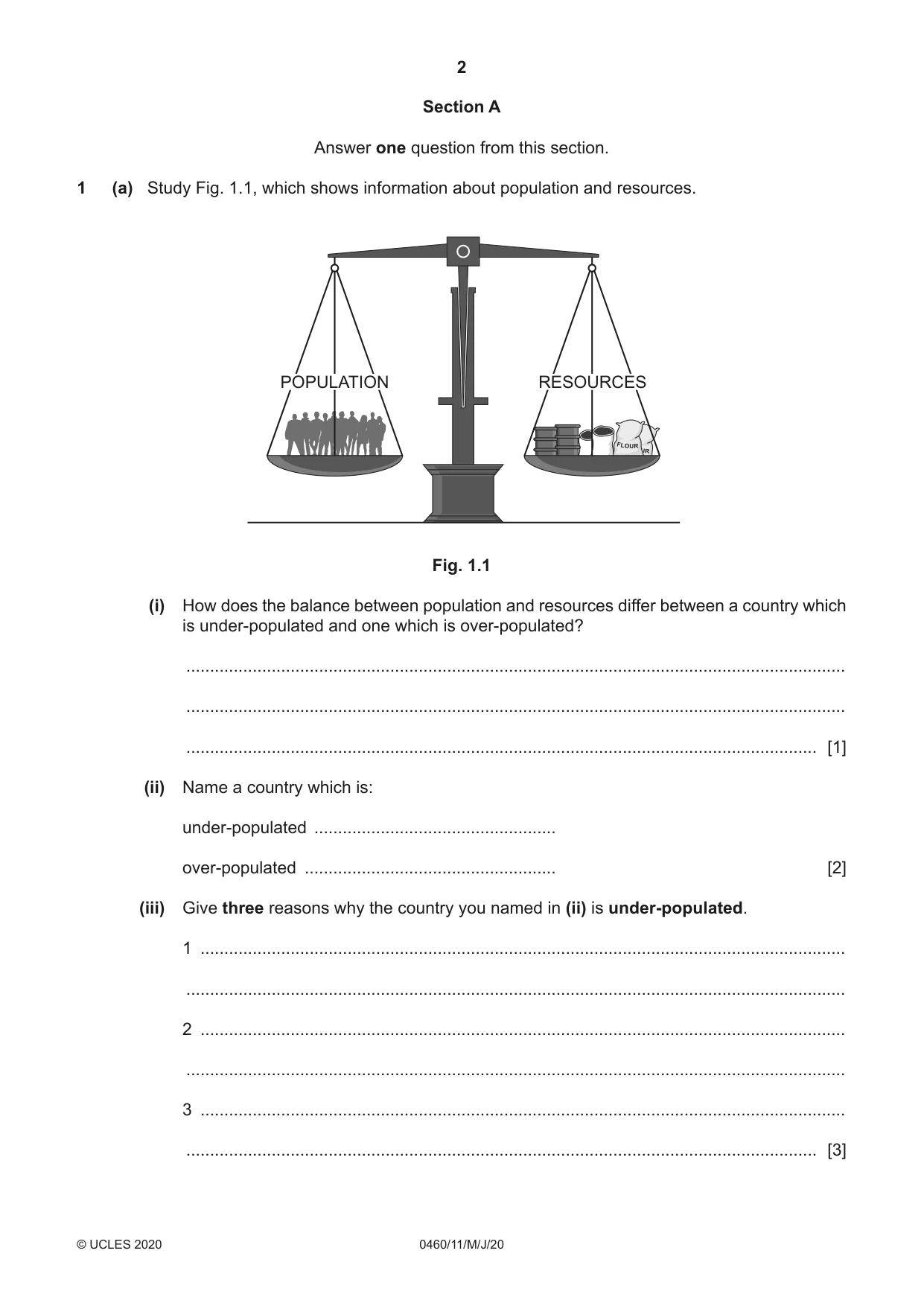
2 0460/11/M/J/20 © UCLES 2020 Section A Answer one question from this section. 1 (a) Study Fig. 1.1, which shows information about population and resources. RESOURCES POPULATION Fig. 1.1 (i) How does the balance between population and resources differ between a country which is under-populated and one which is over-populated? … … … [1] (ii) Name a country which is: under-populated … over-populated … [2] (iii) Give three reasons why the country you named in (ii) is under-populated. 1 … … 2 … … 3 … … [3]
Question paper, page 3
3 0460/11/M/J/20 © UCLES 2020 [Turn over (iv) Describe the problems caused by over-population in the country you named in (ii). … … … … … … … … [4]
Question paper, page 4
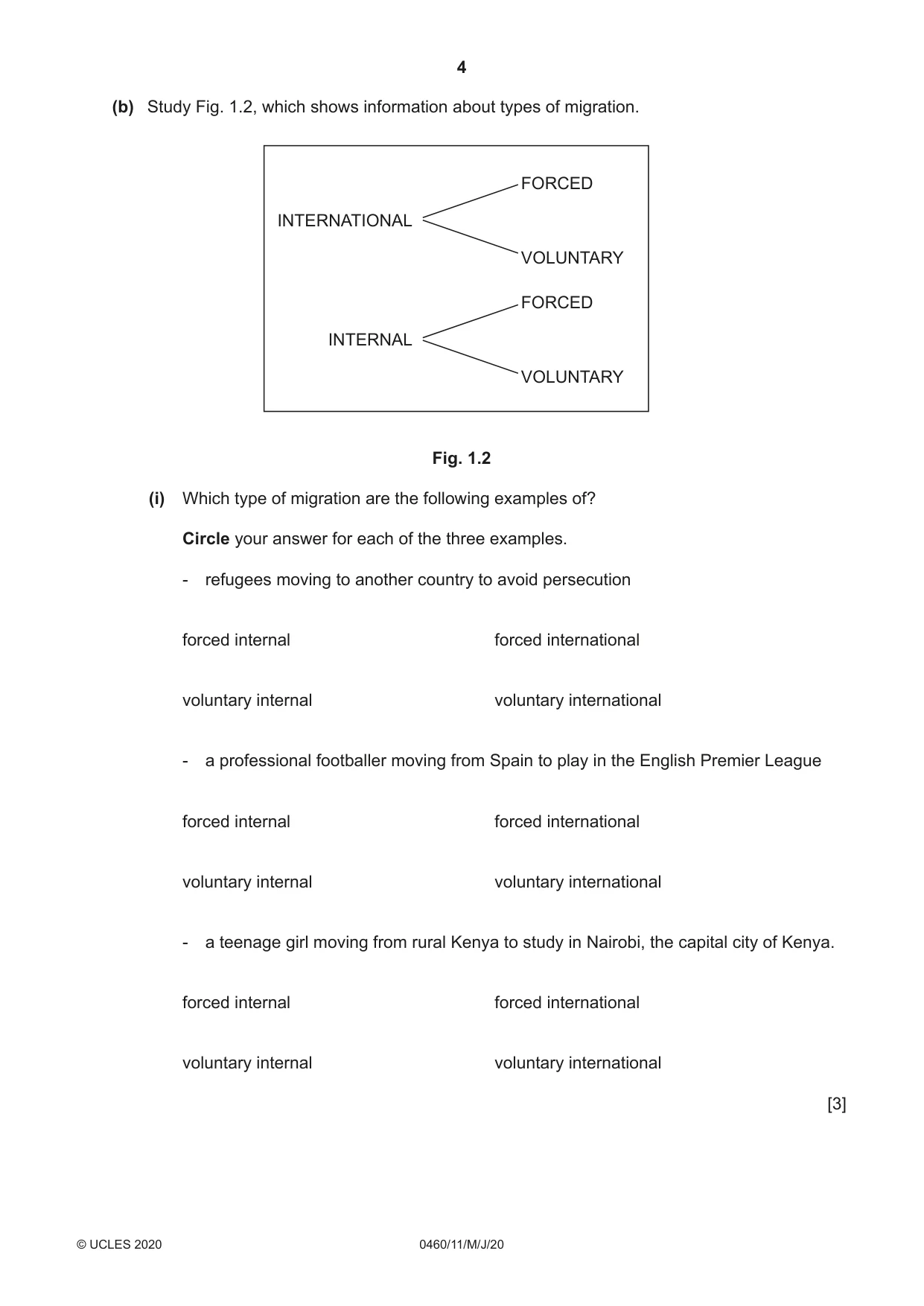
4 0460/11/M/J/20 © UCLES 2020 (b) Study Fig. 1.2, which shows information about types of migration. INTERNATIONAL FORCED VOLUNTARY FORCED VOLUNTARY INTERNAL Fig. 1.2 (i) Which type of migration are the following examples of? Circle your answer for each of the three examples. - refugees moving to another country to avoid persecution forced internal forced international voluntary internal voluntary international - a professional footballer moving from Spain to play in the English Premier League forced internal forced international voluntary internal voluntary international - a teenage girl moving from rural Kenya to study in Nairobi, the capital city of Kenya. forced internal forced international voluntary internal voluntary international [3]
Question paper, page 5
5 0460/11/M/J/20 © UCLES 2020 [Turn over (ii) Describe the difficulties which international migrants may face when moving to, and settling in, another country. … … … … … … … … … … [5]
Question paper, page 6
6 0460/11/M/J/20 © UCLES 2020 (c) Describe the positive and negative impacts of large numbers of immigrants on a country you have studied. Name of country … … … … … … … … … … … … … … … … … … … … … … … … … [7] [Total: 25]
Question paper, page 7
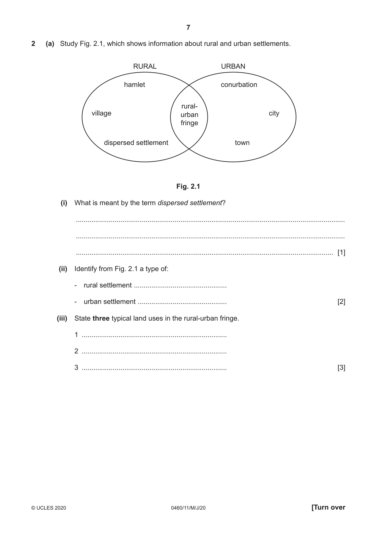
7 0460/11/M/J/20 © UCLES 2020 [Turn over 2 (a) Study Fig. 2.1, which shows information about rural and urban settlements. rural- urban fringe hamlet conurbation village city dispersed settlement town RURAL URBAN Fig. 2.1 (i) What is meant by the term dispersed settlement? … … … [1] (ii) Identify from Fig. 2.1 a type of: - rural settlement … - urban settlement … [2] (iii) State three typical land uses in the rural-urban fringe. 1 … 2 … 3 … [3]
Question paper, page 8
8 0460/11/M/J/20 © UCLES 2020 (iv) Describe the problems caused by urban sprawl. … … … … … … … … [4]
Question paper, page 9
9 0460/11/M/J/20 © UCLES 2020 [Turn over TURN PAGE FOR QUESTION 2(b)
Question paper, page 10
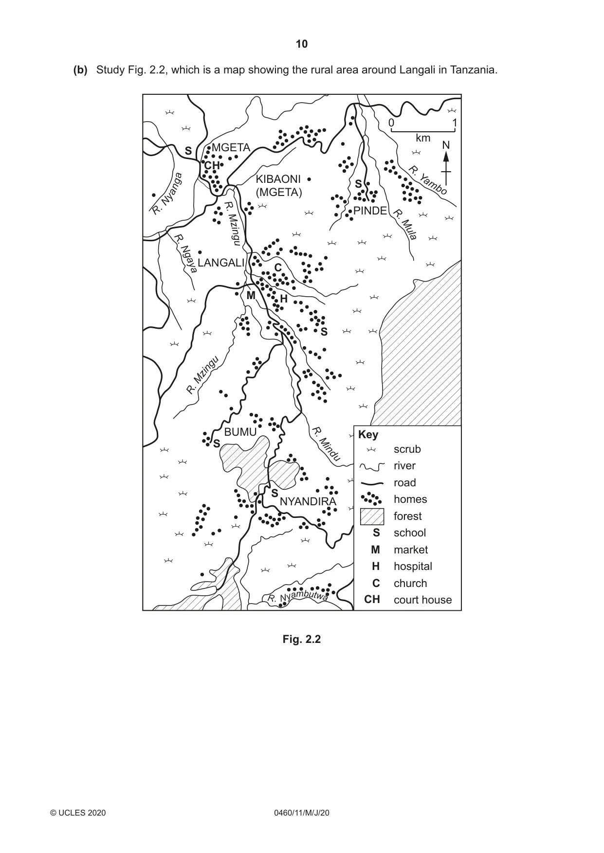
10 0460/11/M/J/20 © UCLES 2020 (b) Study Fig. 2.2, which is a map showing the rural area around Langali in Tanzania. S C S M H S S S CH R . N y a n g a R. Ng ay a R. Mz in gu R. Mz in gu R . N y a m b u t w a R . M ul a R. Y a m bo R. M in du KIBAONI (MGETA) PINDE BUMU NYANDIRA MGETA LANGALI 0 1 km N S M H C CH Key scrub river road homes forest school market hospital church court house Fig. 2.2
Question paper, page 11
11 0460/11/M/J/20 © UCLES 2020 [Turn over (i) Describe the distribution of homes in the area shown in Fig. 2.2. … … … … … … [3] (ii) Suggest reasons for the distribution of homes in the area shown in Fig. 2.2. … … … … … … … … … … [5]
Question paper, page 12
12 0460/11/M/J/20 © UCLES 2020 (c) For a named settlement you have studied, describe and explain the service provision. You should refer to the type and order of services, and their spheres of influence. Name of settlement … … … … … … … … … … … … … … … … … … … … … … … … … [7] [Total: 25]
Question paper, page 13
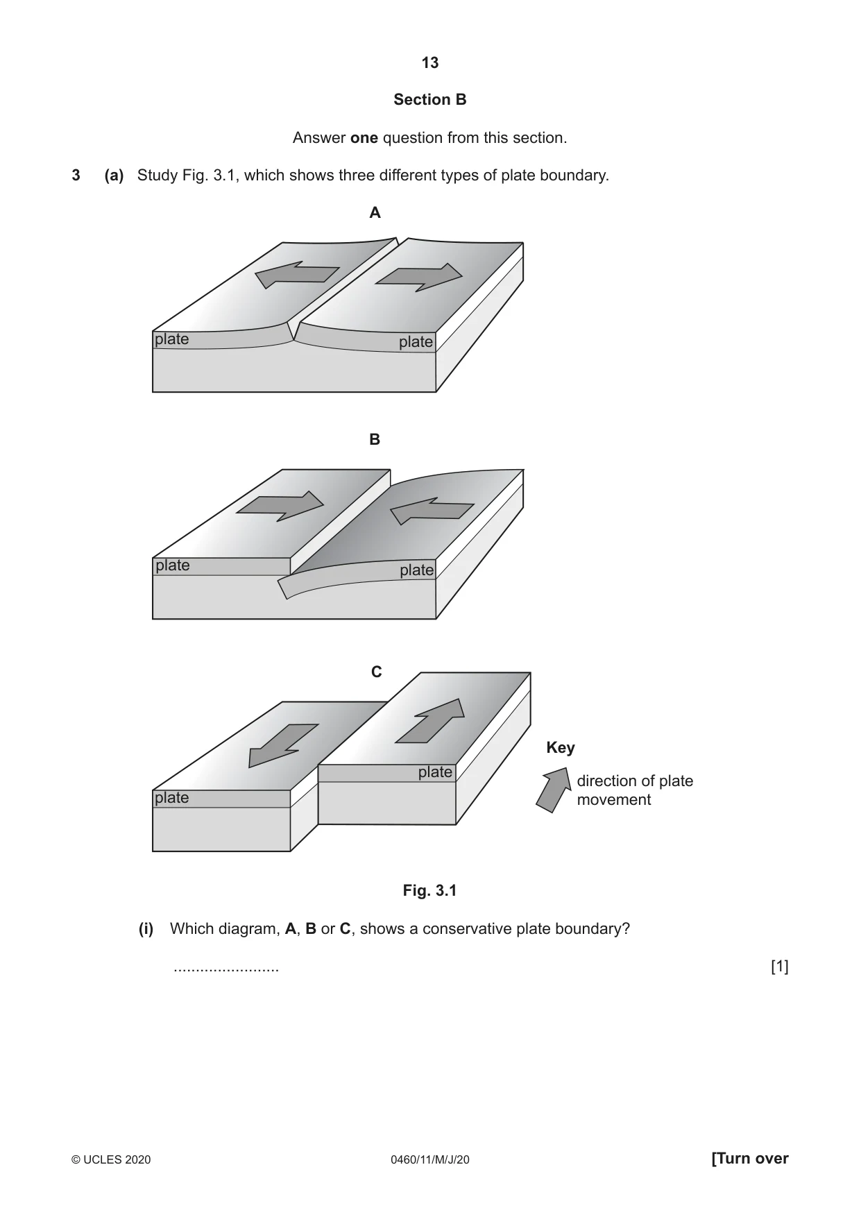
13 0460/11/M/J/20 © UCLES 2020 [Turn over Section B Answer one question from this section. 3 (a) Study Fig. 3.1, which shows three different types of plate boundary. B plate plate A plate plate C plate plate Key direction of plate movement Fig. 3.1 (i) Which diagram, A, B or C, shows a conservative plate boundary? … [1]
Question paper, page 14
14 0460/11/M/J/20 © UCLES 2020 (ii) Shield volcanoes are often formed on constructive (divergent) plate boundaries. Describe two characteristics of a shield volcano. 1 … … 2 … … [2] (iii) Explain how the process of subduction causes volcanoes to form on destructive (convergent) plate boundaries. … … … … … … [3] (iv) Explain what can be done to reduce the impacts of eruptions on people who live near volcanoes. … … … … … … … … [4]
Question paper, page 15
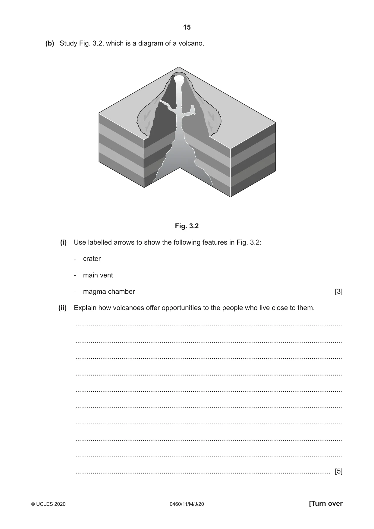
15 0460/11/M/J/20 © UCLES 2020 [Turn over (b) Study Fig. 3.2, which is a diagram of a volcano. Fig. 3.2 (i) Use labelled arrows to show the following features in Fig. 3.2: - crater - main vent - magma chamber [3] (ii) Explain how volcanoes offer opportunities to the people who live close to them. … … … … … … … … … … [5]
Question paper, page 16
16 0460/11/M/J/20 © UCLES 2020 (c) Explain why an earthquake occurred in a named area you have studied. Name of area … … … … … … … … … … … … … … … … … … … … … … … … … … [7] [Total: 25]
Question paper, page 17
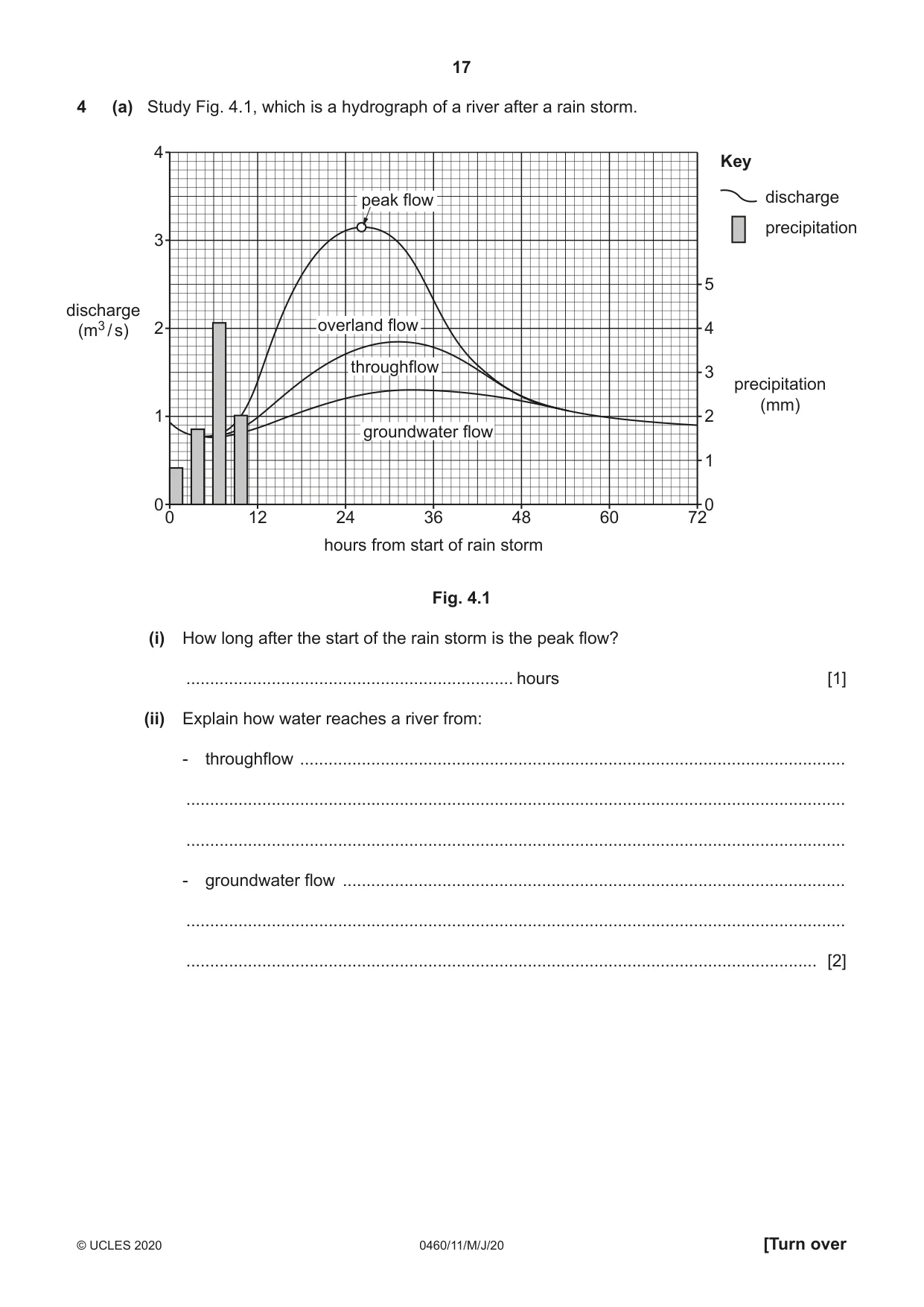
17 0460/11/M/J/20 © UCLES 2020 [Turn over 4 (a) Study Fig. 4.1, which is a hydrograph of a river after a rain storm. hours from start of rain storm discharge (m3 / s) precipitation (mm) 0 1 2 3 4 5 0 0 1 2 3 4 12 24 36 48 60 72 overland flow groundwater flow throughflow peak flow Key discharge precipitation Fig. 4.1 (i) How long after the start of the rain storm is the peak flow? … hours [1] (ii) Explain how water reaches a river from: - throughflow … … … - groundwater flow … … … [2]
Question paper, page 18
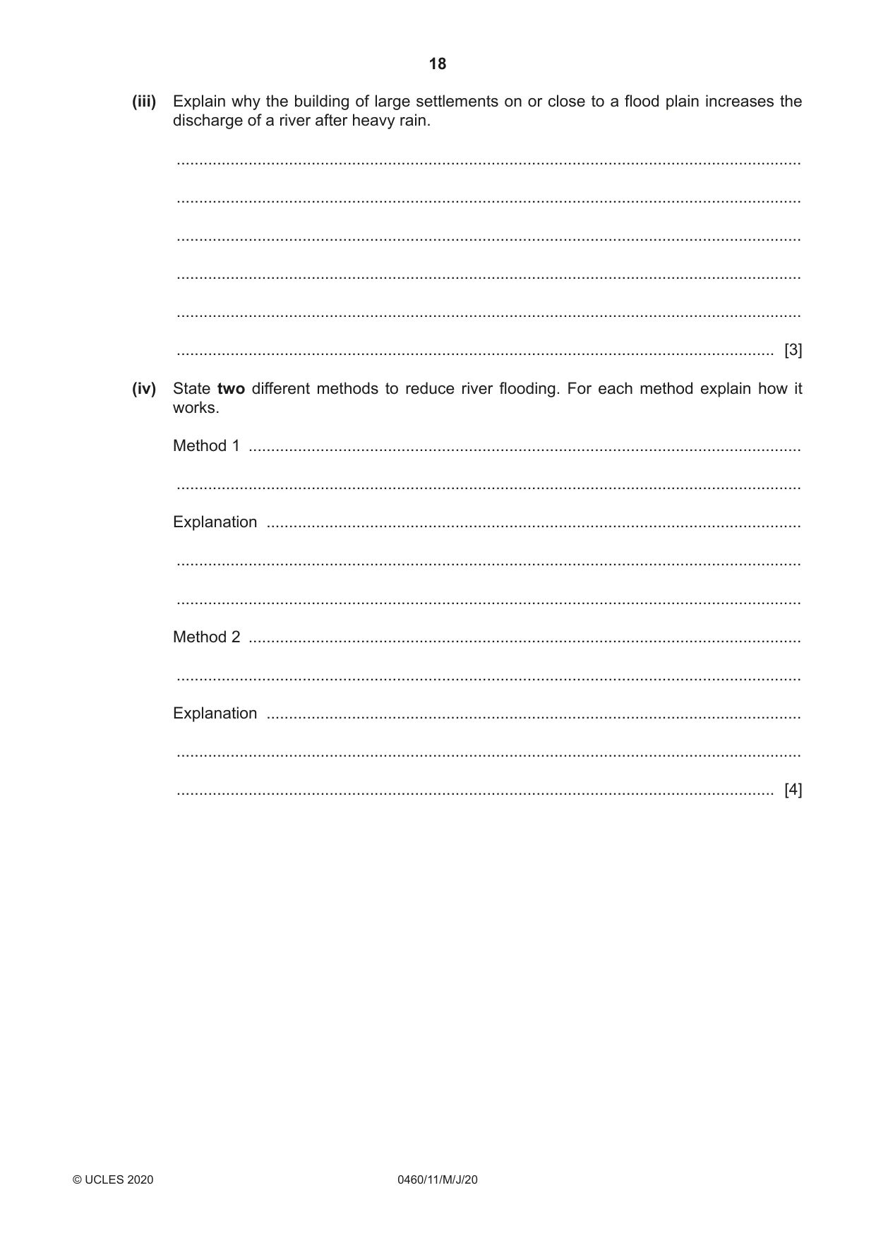
18 0460/11/M/J/20 © UCLES 2020 (iii) Explain why the building of large settlements on or close to a flood plain increases the discharge of a river after heavy rain. … … … … … … [3] (iv) State two different methods to reduce river flooding. For each method explain how it works. Method 1 … … Explanation … … … Method 2 … … Explanation … … … [4]
Question paper, page 19
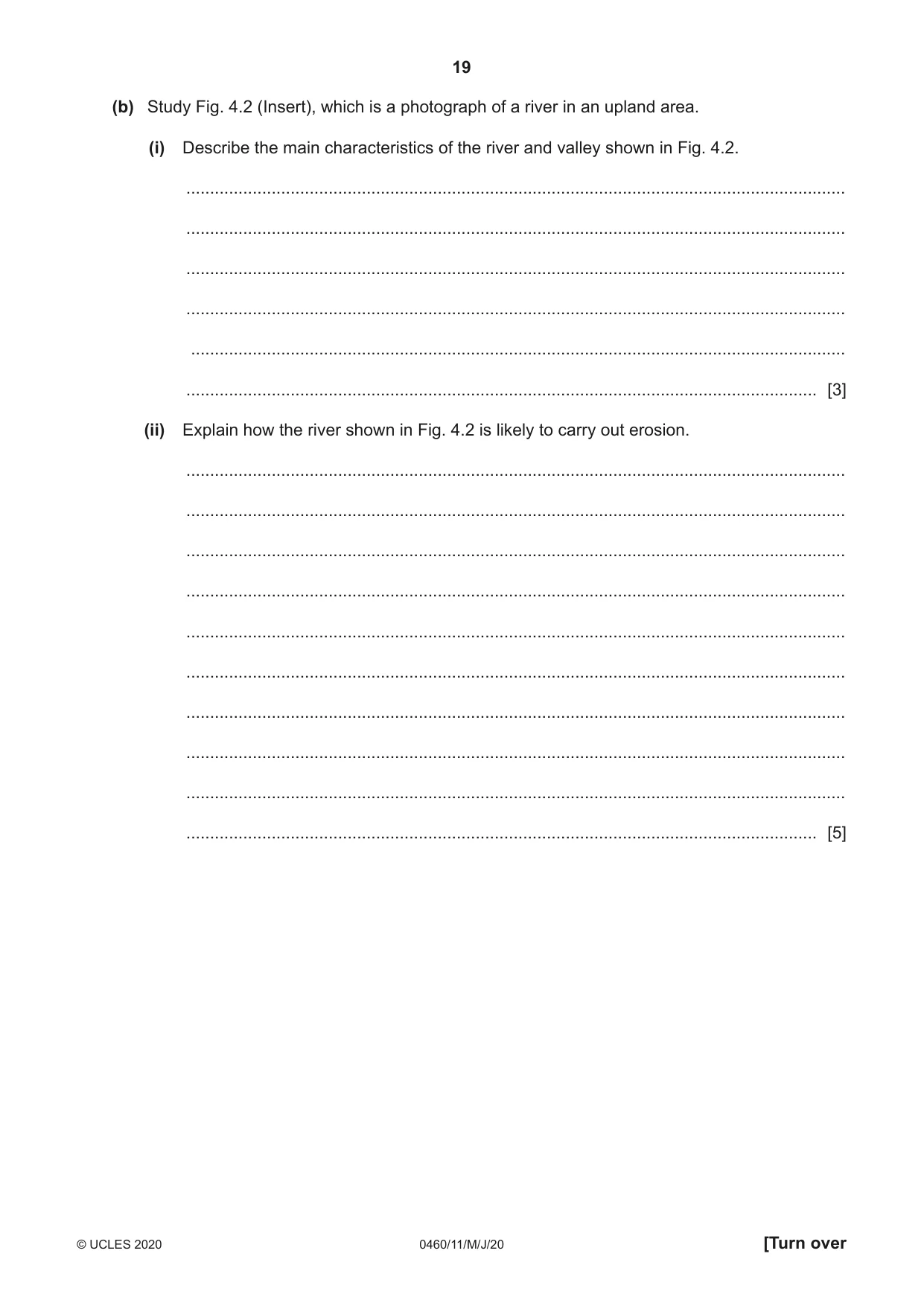
19 0460/11/M/J/20 © UCLES 2020 [Turn over (b) Study Fig. 4.2 (Insert), which is a photograph of a river in an upland area. (i) Describe the main characteristics of the river and valley shown in Fig. 4.2. … … … … … … [3] (ii) Explain how the river shown in Fig. 4.2 is likely to carry out erosion. … … … … … … … … … … [5]
Question paper, page 20
20 0460/11/M/J/20 © UCLES 2020 (c) Describe the opportunities provided for local people by a named river you have studied. Name of river … … … … … … … … … … … … … … … … … … … … … … … … … … [7] [Total: 25]
Question paper, page 21
21 0460/11/M/J/20 © UCLES 2020 [Turn over TURN PAGE FOR QUESTION 5
Question paper, page 22
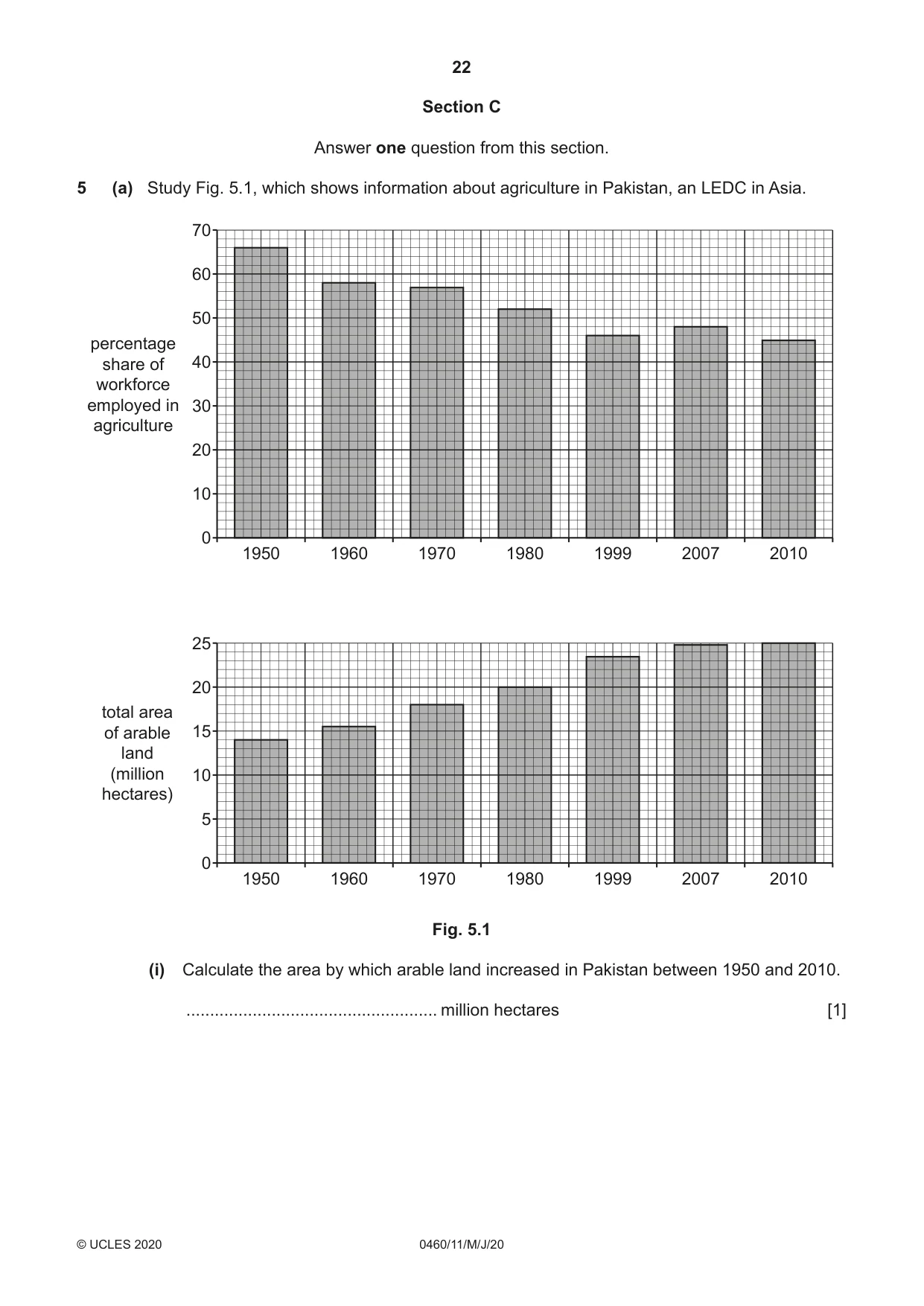
22 0460/11/M/J/20 © UCLES 2020 Section C Answer one question from this section. 5 (a) Study Fig. 5.1, which shows information about agriculture in Pakistan, an LEDC in Asia. 1950 1960 1970 1980 1999 2007 2010 70 60 50 40 30 20 10 0 percentage share of workforce employed in agriculture 1950 1960 1970 1980 1999 2007 2010 25 20 15 10 5 0 total area of arable land (million hectares) Fig. 5.1 (i) Calculate the area by which arable land increased in Pakistan between 1950 and 2010. … million hectares [1]
Question paper, page 23
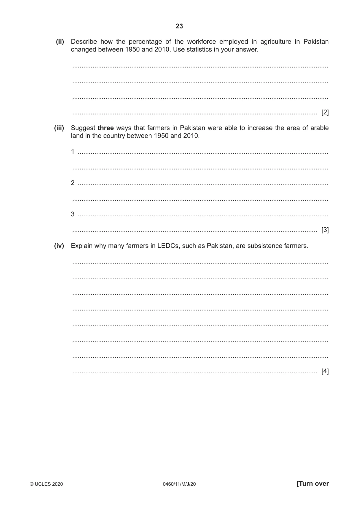
23 0460/11/M/J/20 © UCLES 2020 [Turn over (ii) Describe how the percentage of the workforce employed in agriculture in Pakistan changed between 1950 and 2010. Use statistics in your answer. … … … … [2] (iii) Suggest three ways that farmers in Pakistan were able to increase the area of arable land in the country between 1950 and 2010. 1 … … 2 … … 3 … … [3] (iv) Explain why many farmers in LEDCs, such as Pakistan, are subsistence farmers. … … … … … … … … [4]
Question paper, page 24
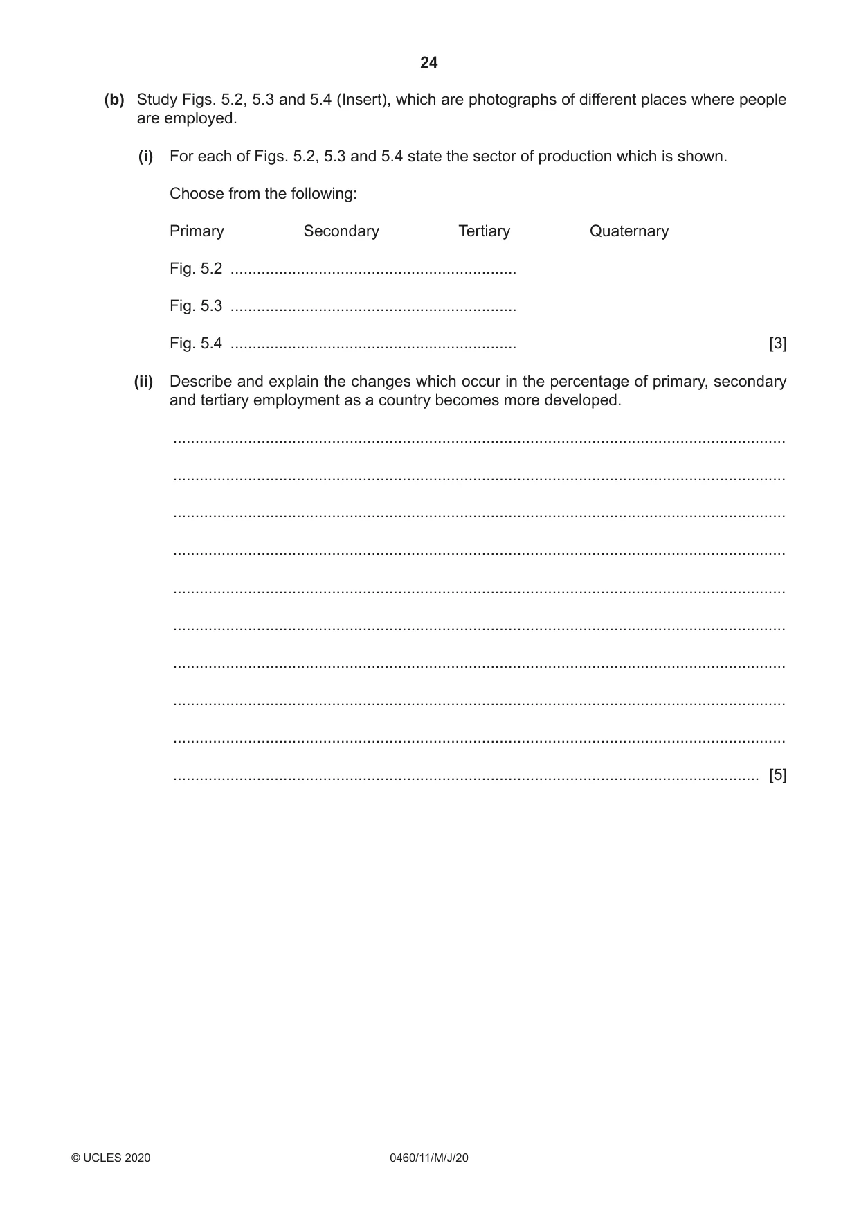
24 0460/11/M/J/20 © UCLES 2020 (b) Study Figs. 5.2, 5.3 and 5.4 (Insert), which are photographs of different places where people are employed. (i) For each of Figs. 5.2, 5.3 and 5.4 state the sector of production which is shown. Choose from the following: Primary Secondary Tertiary Quaternary Fig. 5.2 … Fig. 5.3 … Fig. 5.4 … [3] (ii) Describe and explain the changes which occur in the percentage of primary, secondary and tertiary employment as a country becomes more developed. … … … … … … … … … … [5]
Question paper, page 25
25 0460/11/M/J/20 © UCLES 2020 [Turn over (c) For a named country or area you have studied, explain the causes of food shortages. Name of country or area … … … … … … … … … … … … … … … … … … … … … … … … … … [7] [Total: 25]
Question paper, page 26
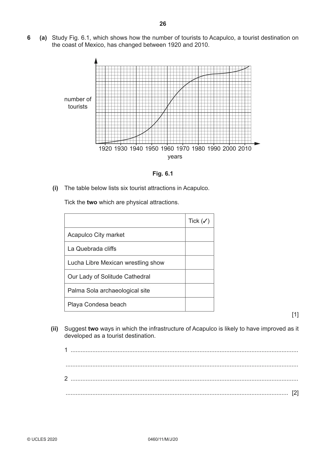
26 0460/11/M/J/20 © UCLES 2020 6 (a) Study Fig. 6.1, which shows how the number of tourists to Acapulco, a tourist destination on the coast of Mexico, has changed between 1920 and 2010. 1920 1930 1940 1950 1960 1970 years 1980 1990 2000 2010 number of tourists Fig. 6.1 (i) The table below lists six tourist attractions in Acapulco. Tick the two which are physical attractions. Tick (✓) Acapulco City market La Quebrada cliffs Lucha Libre Mexican wrestling show Our Lady of Solitude Cathedral Palma Sola archaeological site Playa Condesa beach [1] (ii) Suggest two ways in which the infrastructure of Acapulco is likely to have improved as it developed as a tourist destination. 1 … … 2 … … [2]
Question paper, page 27
27 0460/11/M/J/20 © UCLES 2020 [Turn over (iii) Suggest why the growth of tourism in the Acapulco area may have had both positive and negative effects on local fishermen. … … … … … … … [3] (iv) Using Fig. 6.1 only, describe the changes in the number of tourists in Acapulco between 1920 and 2010. … … … … … … … … [4]
Question paper, page 28
28 0460/11/M/J/20 © UCLES 2020 (b) Study Fig. 6.2 (Insert), which is an advert for a tourist resort in the Silvassa Forest region in India (an LEDC). (i) State three different types of job which are likely to have been created by tourism in the Silvassa Forest region. 1 … 2 … 3 … [3] (ii) Explain how the local natural environment may be at risk from tourist resorts such as the one shown in Fig. 6.2. … … … … … … … … … … [5]
Question paper, page 29
29 0460/11/M/J/20 © UCLES 2020 (c) For a named area you have studied, explain how tourism is managed in order for it to be sustainable. Name of area … … … … … … … … … … … … … … … … … … … … … … … … … … [7] [Total: 25]
Question paper, page 30
30 0460/11/M/J/20 © UCLES 2020 Additional Pages If you use the following lined pages to complete the answer(s) to any question(s), the question number(s) must be clearly shown. … … … … … … … … … … … … … … … … … … … … … … … … … …
Question paper, page 31
31 0460/11/M/J/20 © UCLES 2020 … … … … … … … … … … … … … … … … … … … … … … … … … … … …
Question paper, page 32
32 0460/11/M/J/20 © UCLES 2020 Permission to reproduce items where third-party owned material protected by copyright is included has been sought and cleared where possible. Every reasonable effort has been made by the publisher (UCLES) to trace copyright holders, but if any items requiring clearance have unwittingly been included, the publisher will be pleased to make amends at the earliest possible opportunity. To avoid the issue of disclosure of answer-related information to candidates, all copyright acknowledgements are reproduced online in the Cambridge Assessment International Education Copyright Acknowledgements Booklet. This is produced for each series of examinations and is freely available to download at www.cambridgeinternational.org after the live examination series. Cambridge Assessment International Education is part of the Cambridge Assessment Group. Cambridge Assessment is the brand name of the University of Cambridge Local Examinations Syndicate (UCLES), which itself is a department of the University of Cambridge. BLANK PAGE
Mark scheme, page 1
This document consists of 14 printed pages. © UCLES 2020 [Turn over Cambridge IGCSE™ GEOGRAPHY 0460/11 Paper 1 May/June 2020 MARK SCHEME Maximum Mark: 75 Published Students did not sit exam papers in the June 2020 series due to the Covid-19 global pandemic. This mark scheme is published to support teachers and students and should be read together with the question paper. It shows the requirements of the exam. The answer column of the mark scheme shows the proposed basis on which Examiners would award marks for this exam. Where appropriate, this column also provides the most likely acceptable alternative responses expected from students. Examiners usually review the mark scheme after they have seen student responses and update the mark scheme if appropriate. In the June series, Examiners were unable to consider the acceptability of alternative responses, as there were no student responses to consider. Mark schemes should usually be read together with the Principal Examiner Report for Teachers. However, because students did not sit exam papers, there is no Principal Examiner Report for Teachers for the June 2020 series. Cambridge International will not enter into discussions about these mark schemes. Cambridge International is publishing the mark schemes for the June 2020 series for most Cambridge IGCSE™ and Cambridge International A & AS Level components, and some Cambridge O Level components.
Mark scheme, page 2
0460/11 Cambridge IGCSE – Mark Scheme PUBLISHED May/June 2020 © UCLES 2020 Page 2 of 14 Generic Marking Principles These general marking principles must be applied by all examiners when marking candidate answers. They should be applied alongside the specific content of the mark scheme or generic level descriptors for a question. Each question paper and mark scheme will also comply with these marking principles. GENERIC MARKING PRINCIPLE 1: Marks must be awarded in line with: • the specific content of the mark scheme or the generic level descriptors for the question • the specific skills defined in the mark scheme or in the generic level descriptors for the question • the standard of response required by a candidate as exemplified by the standardisation scripts. GENERIC MARKING PRINCIPLE 2: Marks awarded are always whole marks (not half marks, or other fractions). GENERIC MARKING PRINCIPLE 3: Marks must be awarded positively: • marks are awarded for correct/valid answers, as defined in the mark scheme. However, credit is given for valid answers which go beyond the scope of the syllabus and mark scheme, referring to your Team Leader as appropriate • marks are awarded when candidates clearly demonstrate what they know and can do • marks are not deducted for errors • marks are not deducted for omissions • answers should only be judged on the quality of spelling, punctuation and grammar when these features are specifically assessed by the question as indicated by the mark scheme. The meaning, however, should be unambiguous. GENERIC MARKING PRINCIPLE 4: Rules must be applied consistently e.g. in situations where candidates have not followed instructions or in the application of generic level descriptors. GENERIC MARKING PRINCIPLE 5: Marks should be awarded using the full range of marks defined in the mark scheme for the question (however; the use of the full mark range may be limited according to the quality of the candidate responses seen). GENERIC MARKING PRINCIPLE 6: Marks awarded are based solely on the requirements as defined in the mark scheme. Marks should not be awarded with grade thresholds or grade descriptors in mind.
Mark scheme, page 3
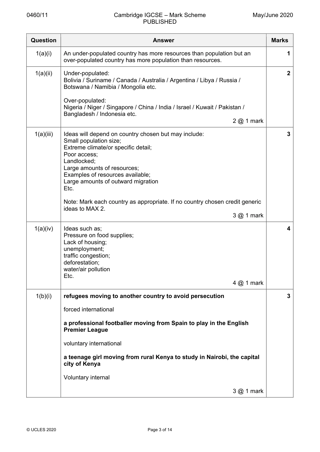
0460/11 Cambridge IGCSE – Mark Scheme PUBLISHED May/June 2020 © UCLES 2020 Page 3 of 14 Question Answer Marks 1(a)(i) An under-populated country has more resources than population but an over-populated country has more population than resources. 1 1(a)(ii) Under-populated: Bolivia / Suriname / Canada / Australia / Argentina / Libya / Russia / Botswana / Namibia / Mongolia etc. Over-populated: Nigeria / Niger / Singapore / China / India / Israel / Kuwait / Pakistan / Bangladesh / Indonesia etc. 2 @ 1 mark 2 1(a)(iii) Ideas will depend on country chosen but may include: Small population size; Extreme climate/or specific detail; Poor access; Landlocked; Large amounts of resources; Examples of resources available; Large amounts of outward migration Etc. Note: Mark each country as appropriate. If no country chosen credit generic ideas to MAX 2. 3 @ 1 mark 3 1(a)(iv) Ideas such as; Pressure on food supplies; Lack of housing; unemployment; traffic congestion; deforestation; water/air pollution Etc. 4 @ 1 mark 4 1(b)(i) refugees moving to another country to avoid persecution forced international a professional footballer moving from Spain to play in the English Premier League voluntary international a teenage girl moving from rural Kenya to study in Nairobi, the capital city of Kenya Voluntary internal 3 @ 1 mark 3
Mark scheme, page 4
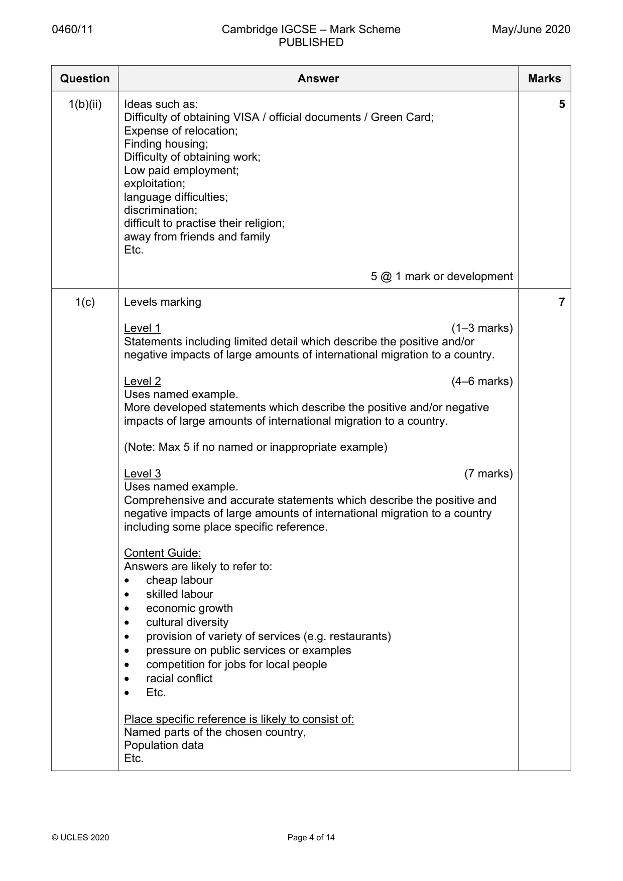
0460/11 Cambridge IGCSE – Mark Scheme PUBLISHED May/June 2020 © UCLES 2020 Page 4 of 14 Question Answer Marks 1(b)(ii) Ideas such as: Difficulty of obtaining VISA / official documents / Green Card; Expense of relocation; Finding housing; Difficulty of obtaining work; Low paid employment; exploitation; language difficulties; discrimination; difficult to practise their religion; away from friends and family Etc. 5 @ 1 mark or development 5 1(c) Levels marking Level 1 (1–3 marks) Statements including limited detail which describe the positive and/or negative impacts of large amounts of international migration to a country. Level 2 (4–6 marks) Uses named example. More developed statements which describe the positive and/or negative impacts of large amounts of international migration to a country. (Note: Max 5 if no named or inappropriate example) Level 3 (7 marks) Uses named example. Comprehensive and accurate statements which describe the positive and negative impacts of large amounts of international migration to a country including some place specific reference. Content Guide: Answers are likely to refer to: • cheap labour • skilled labour • economic growth • cultural diversity • provision of variety of services (e.g. restaurants) • pressure on public services or examples • competition for jobs for local people • racial conflict • Etc. Place specific reference is likely to consist of: Named parts of the chosen country, Population data Etc. 7
Mark scheme, page 5
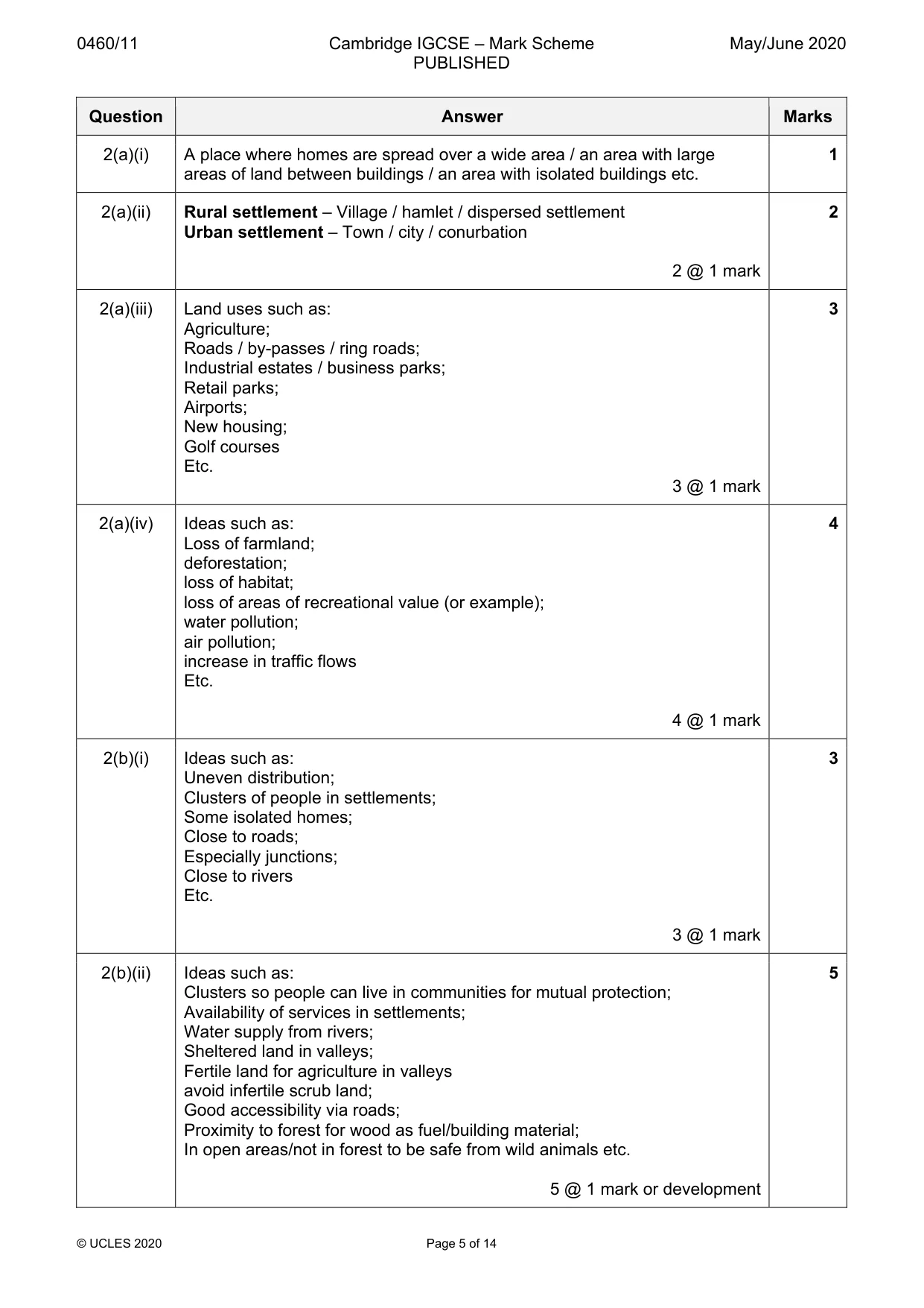
0460/11 Cambridge IGCSE – Mark Scheme PUBLISHED May/June 2020 © UCLES 2020 Page 5 of 14 Question Answer Marks 2(a)(i) A place where homes are spread over a wide area / an area with large areas of land between buildings / an area with isolated buildings etc. 1 2(a)(ii) Rural settlement – Village / hamlet / dispersed settlement Urban settlement – Town / city / conurbation 2 @ 1 mark 2 2(a)(iii) Land uses such as: Agriculture; Roads / by-passes / ring roads; Industrial estates / business parks; Retail parks; Airports; New housing; Golf courses Etc. 3 @ 1 mark 3 2(a)(iv) Ideas such as: Loss of farmland; deforestation; loss of habitat; loss of areas of recreational value (or example); water pollution; air pollution; increase in traffic flows Etc. 4 @ 1 mark 4 2(b)(i) Ideas such as: Uneven distribution; Clusters of people in settlements; Some isolated homes; Close to roads; Especially junctions; Close to rivers Etc. 3 @ 1 mark 3 2(b)(ii) Ideas such as: Clusters so people can live in communities for mutual protection; Availability of services in settlements; Water supply from rivers; Sheltered land in valleys; Fertile land for agriculture in valleys avoid infertile scrub land; Good accessibility via roads; Proximity to forest for wood as fuel/building material; In open areas/not in forest to be safe from wild animals etc. 5 @ 1 mark or development 5
Mark scheme, page 6
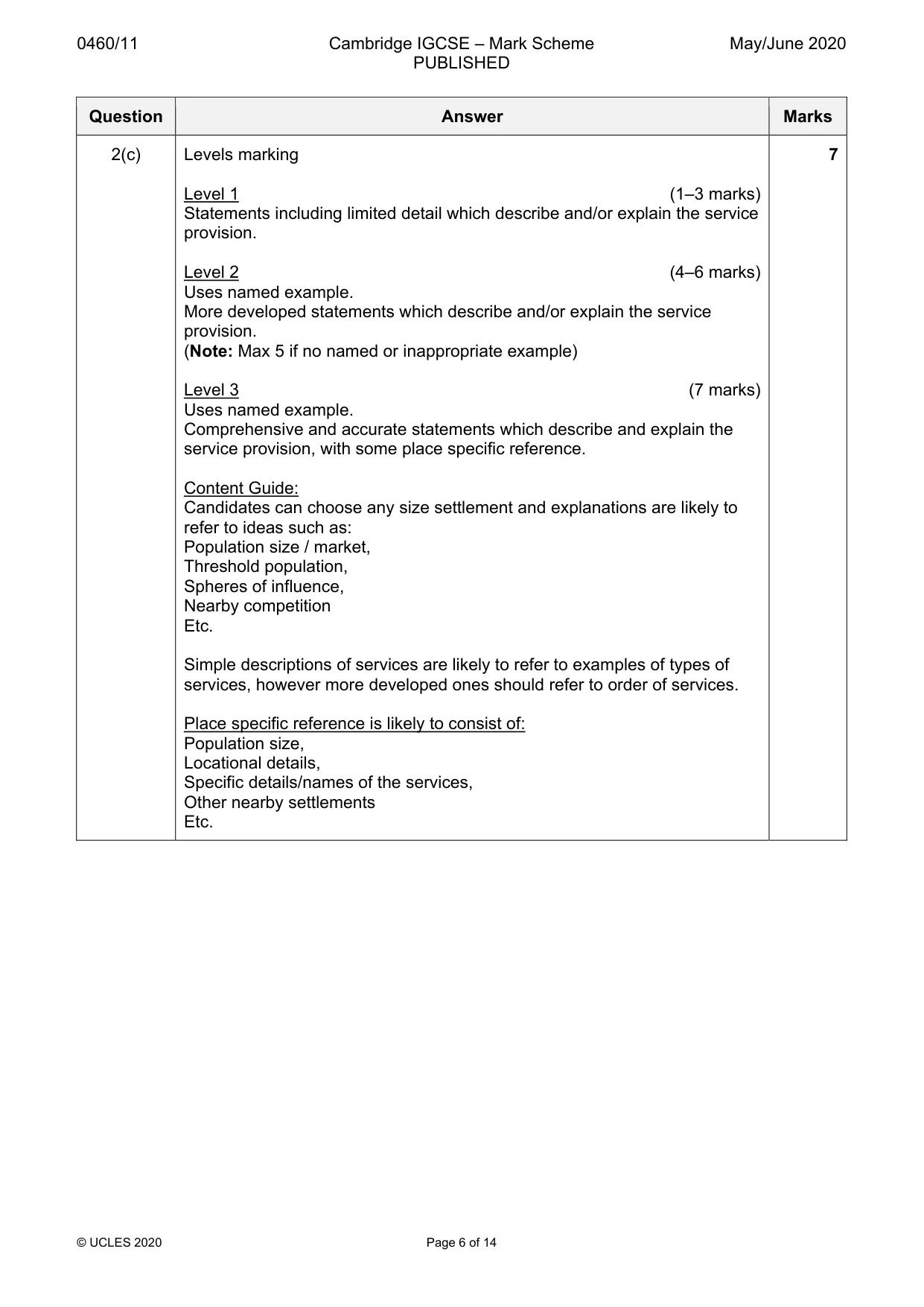
0460/11 Cambridge IGCSE – Mark Scheme PUBLISHED May/June 2020 © UCLES 2020 Page 6 of 14 Question Answer Marks 2(c) Levels marking Level 1 (1–3 marks) Statements including limited detail which describe and/or explain the service provision. Level 2 (4–6 marks) Uses named example. More developed statements which describe and/or explain the service provision. (Note: Max 5 if no named or inappropriate example) Level 3 (7 marks) Uses named example. Comprehensive and accurate statements which describe and explain the service provision, with some place specific reference. Content Guide: Candidates can choose any size settlement and explanations are likely to refer to ideas such as: Population size / market, Threshold population, Spheres of influence, Nearby competition Etc. Simple descriptions of services are likely to refer to examples of types of services, however more developed ones should refer to order of services. Place specific reference is likely to consist of: Population size, Locational details, Specific details/names of the services, Other nearby settlements Etc. 7
Mark scheme, page 7
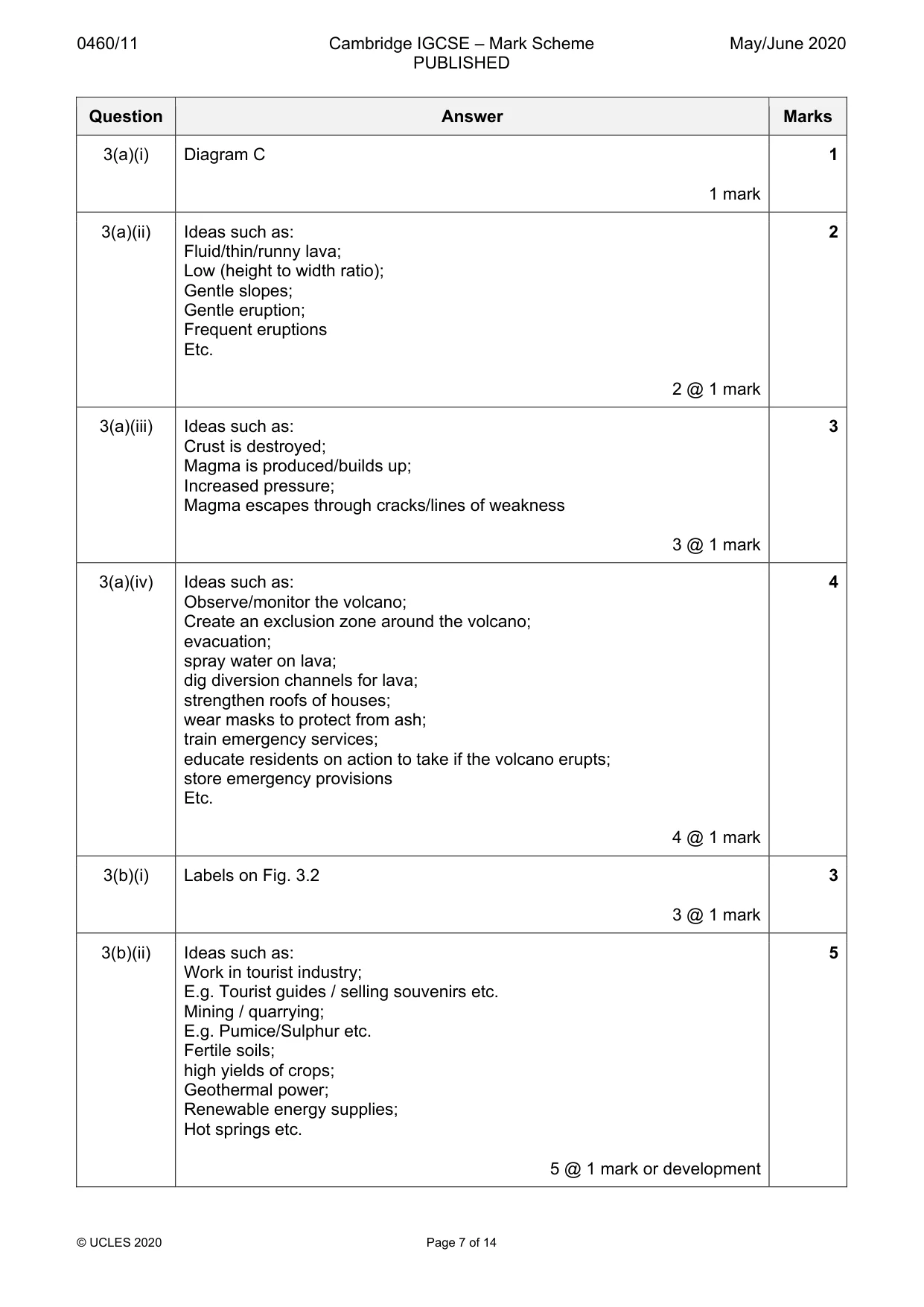
0460/11 Cambridge IGCSE – Mark Scheme PUBLISHED May/June 2020 © UCLES 2020 Page 7 of 14 Question Answer Marks 3(a)(i) Diagram C 1 mark 1 3(a)(ii) Ideas such as: Fluid/thin/runny lava; Low (height to width ratio); Gentle slopes; Gentle eruption; Frequent eruptions Etc. 2 @ 1 mark 2 3(a)(iii) Ideas such as: Crust is destroyed; Magma is produced/builds up; Increased pressure; Magma escapes through cracks/lines of weakness 3 @ 1 mark 3 3(a)(iv) Ideas such as: Observe/monitor the volcano; Create an exclusion zone around the volcano; evacuation; spray water on lava; dig diversion channels for lava; strengthen roofs of houses; wear masks to protect from ash; train emergency services; educate residents on action to take if the volcano erupts; store emergency provisions Etc. 4 @ 1 mark 4 3(b)(i) Labels on Fig. 3.2 3 @ 1 mark 3 3(b)(ii) Ideas such as: Work in tourist industry; E.g. Tourist guides / selling souvenirs etc. Mining / quarrying; E.g. Pumice/Sulphur etc. Fertile soils; high yields of crops; Geothermal power; Renewable energy supplies; Hot springs etc. 5 @ 1 mark or development 5
Mark scheme, page 8
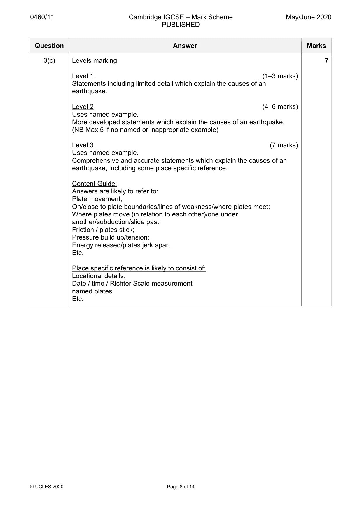
0460/11 Cambridge IGCSE – Mark Scheme PUBLISHED May/June 2020 © UCLES 2020 Page 8 of 14 Question Answer Marks 3(c) Levels marking Level 1 (1–3 marks) Statements including limited detail which explain the causes of an earthquake. Level 2 (4–6 marks) Uses named example. More developed statements which explain the causes of an earthquake. (NB Max 5 if no named or inappropriate example) Level 3 (7 marks) Uses named example. Comprehensive and accurate statements which explain the causes of an earthquake, including some place specific reference. Content Guide: Answers are likely to refer to: Plate movement, On/close to plate boundaries/lines of weakness/where plates meet; Where plates move (in relation to each other)/one under another/subduction/slide past; Friction / plates stick; Pressure build up/tension; Energy released/plates jerk apart Etc. Place specific reference is likely to consist of: Locational details, Date / time / Richter Scale measurement named plates Etc. 7
Mark scheme, page 9
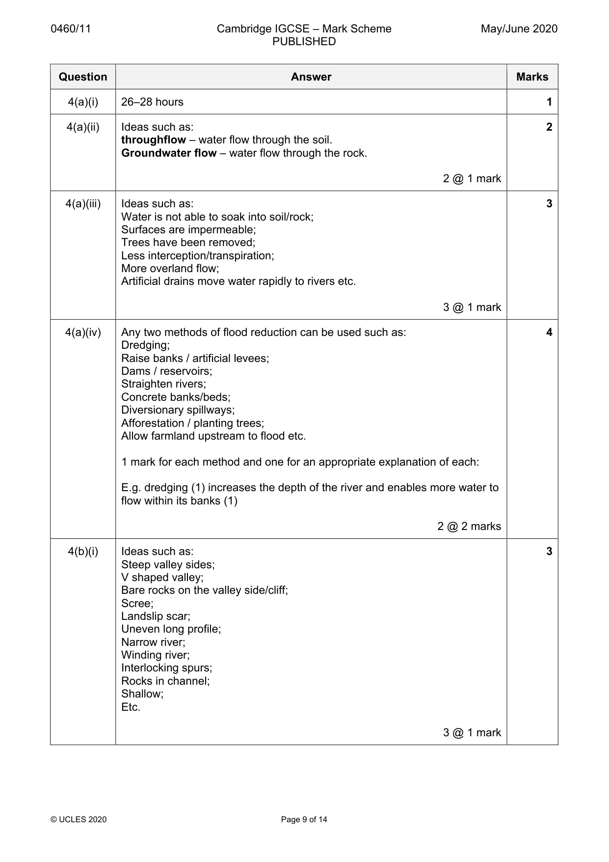
0460/11 Cambridge IGCSE – Mark Scheme PUBLISHED May/June 2020 © UCLES 2020 Page 9 of 14 Question Answer Marks 4(a)(i) 26–28 hours 1 4(a)(ii) Ideas such as: throughflow – water flow through the soil. Groundwater flow – water flow through the rock. 2 @ 1 mark 2 4(a)(iii) Ideas such as: Water is not able to soak into soil/rock; Surfaces are impermeable; Trees have been removed; Less interception/transpiration; More overland flow; Artificial drains move water rapidly to rivers etc. 3 @ 1 mark 3 4(a)(iv) Any two methods of flood reduction can be used such as: Dredging; Raise banks / artificial levees; Dams / reservoirs; Straighten rivers; Concrete banks/beds; Diversionary spillways; Afforestation / planting trees; Allow farmland upstream to flood etc. 1 mark for each method and one for an appropriate explanation of each: E.g. dredging (1) increases the depth of the river and enables more water to flow within its banks (1) 2 @ 2 marks 4 4(b)(i) Ideas such as: Steep valley sides; V shaped valley; Bare rocks on the valley side/cliff; Scree; Landslip scar; Uneven long profile; Narrow river; Winding river; Interlocking spurs; Rocks in channel; Shallow; Etc. 3 @ 1 mark 3
Mark scheme, page 10
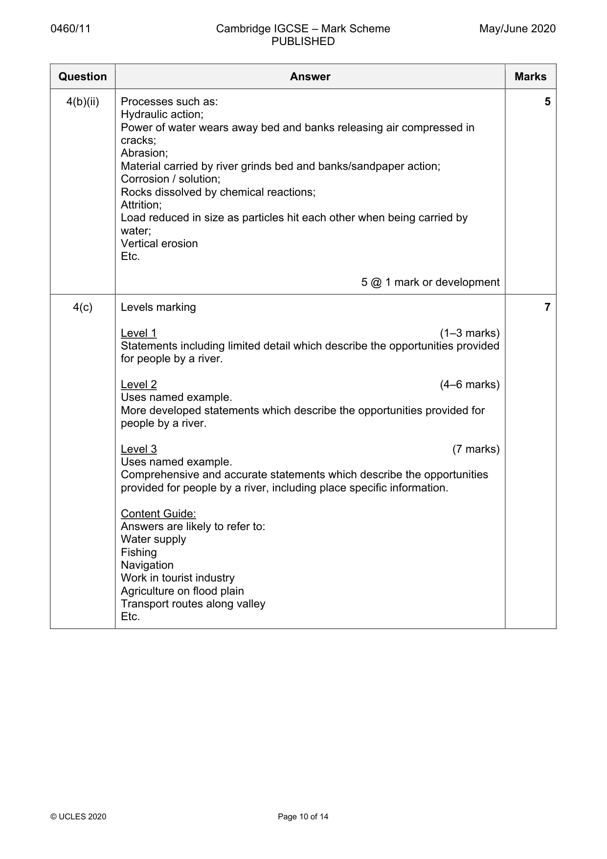
0460/11 Cambridge IGCSE – Mark Scheme PUBLISHED May/June 2020 © UCLES 2020 Page 10 of 14 Question Answer Marks 4(b)(ii) Processes such as: Hydraulic action; Power of water wears away bed and banks releasing air compressed in cracks; Abrasion; Material carried by river grinds bed and banks/sandpaper action; Corrosion / solution; Rocks dissolved by chemical reactions; Attrition; Load reduced in size as particles hit each other when being carried by water; Vertical erosion Etc. 5 @ 1 mark or development 5 4(c) Levels marking Level 1 (1–3 marks) Statements including limited detail which describe the opportunities provided for people by a river. Level 2 (4–6 marks) Uses named example. More developed statements which describe the opportunities provided for people by a river. Level 3 (7 marks) Uses named example. Comprehensive and accurate statements which describe the opportunities provided for people by a river, including place specific information. Content Guide: Answers are likely to refer to: Water supply Fishing Navigation Work in tourist industry Agriculture on flood plain Transport routes along valley Etc. 7
Mark scheme, page 11
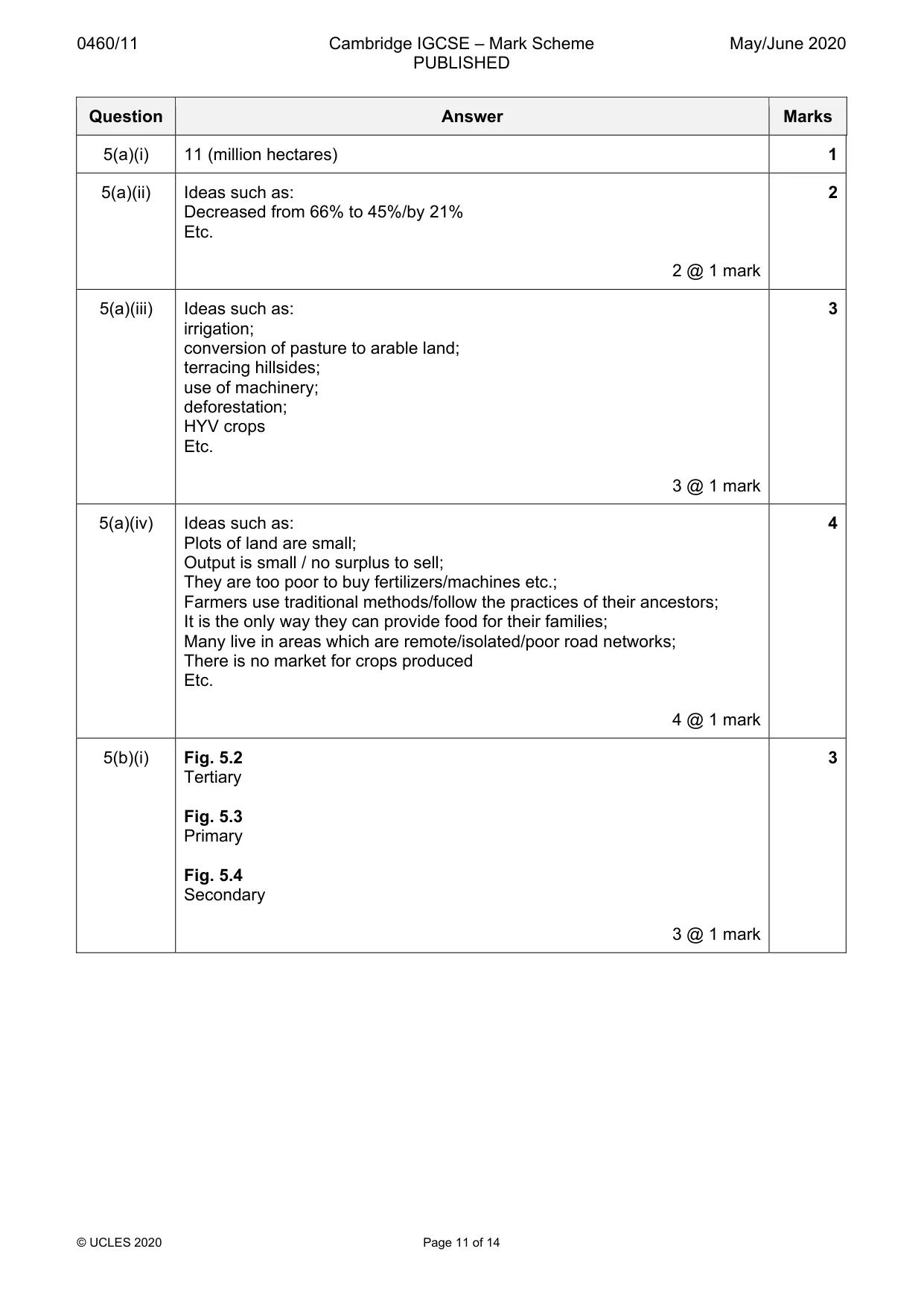
0460/11 Cambridge IGCSE – Mark Scheme PUBLISHED May/June 2020 © UCLES 2020 Page 11 of 14 Question Answer Marks 5(a)(i) 11 (million hectares) 1 5(a)(ii) Ideas such as: Decreased from 66% to 45%/by 21% Etc. 2 @ 1 mark 2 5(a)(iii) Ideas such as: irrigation; conversion of pasture to arable land; terracing hillsides; use of machinery; deforestation; HYV crops Etc. 3 @ 1 mark 3 5(a)(iv) Ideas such as: Plots of land are small; Output is small / no surplus to sell; They are too poor to buy fertilizers/machines etc.; Farmers use traditional methods/follow the practices of their ancestors; It is the only way they can provide food for their families; Many live in areas which are remote/isolated/poor road networks; There is no market for crops produced Etc. 4 @ 1 mark 4 5(b)(i) Fig. 5.2 Tertiary Fig. 5.3 Primary Fig. 5.4 Secondary 3 @ 1 mark 3
Mark scheme, page 12
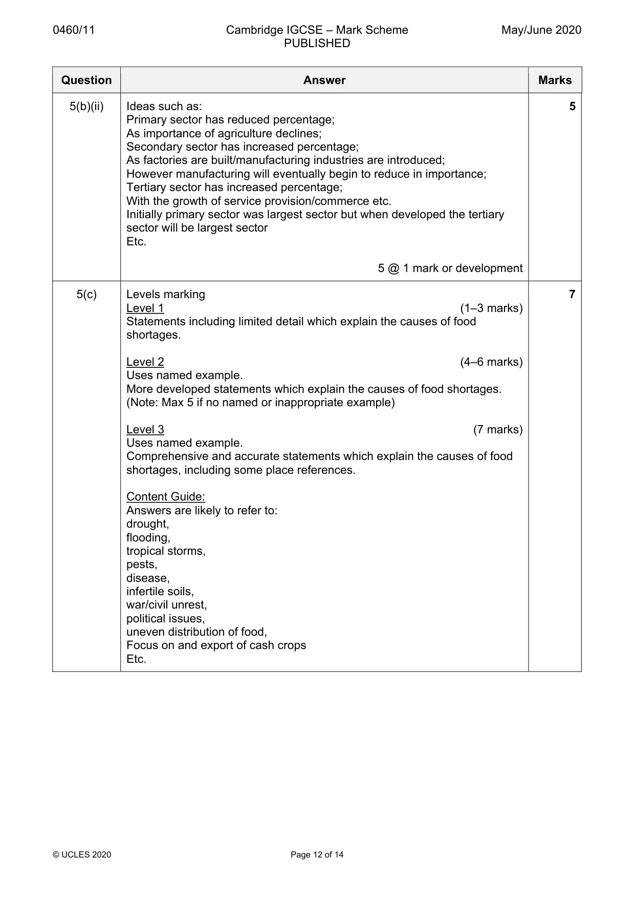
0460/11 Cambridge IGCSE – Mark Scheme PUBLISHED May/June 2020 © UCLES 2020 Page 12 of 14 Question Answer Marks 5(b)(ii) Ideas such as: Primary sector has reduced percentage; As importance of agriculture declines; Secondary sector has increased percentage; As factories are built/manufacturing industries are introduced; However manufacturing will eventually begin to reduce in importance; Tertiary sector has increased percentage; With the growth of service provision/commerce etc. Initially primary sector was largest sector but when developed the tertiary sector will be largest sector Etc. 5 @ 1 mark or development 5 5(c) Levels marking Level 1 (1–3 marks) Statements including limited detail which explain the causes of food shortages. Level 2 (4–6 marks) Uses named example. More developed statements which explain the causes of food shortages. (Note: Max 5 if no named or inappropriate example) Level 3 (7 marks) Uses named example. Comprehensive and accurate statements which explain the causes of food shortages, including some place references. Content Guide: Answers are likely to refer to: drought, flooding, tropical storms, pests, disease, infertile soils, war/civil unrest, political issues, uneven distribution of food, Focus on and export of cash crops Etc. 7
Mark scheme, page 13
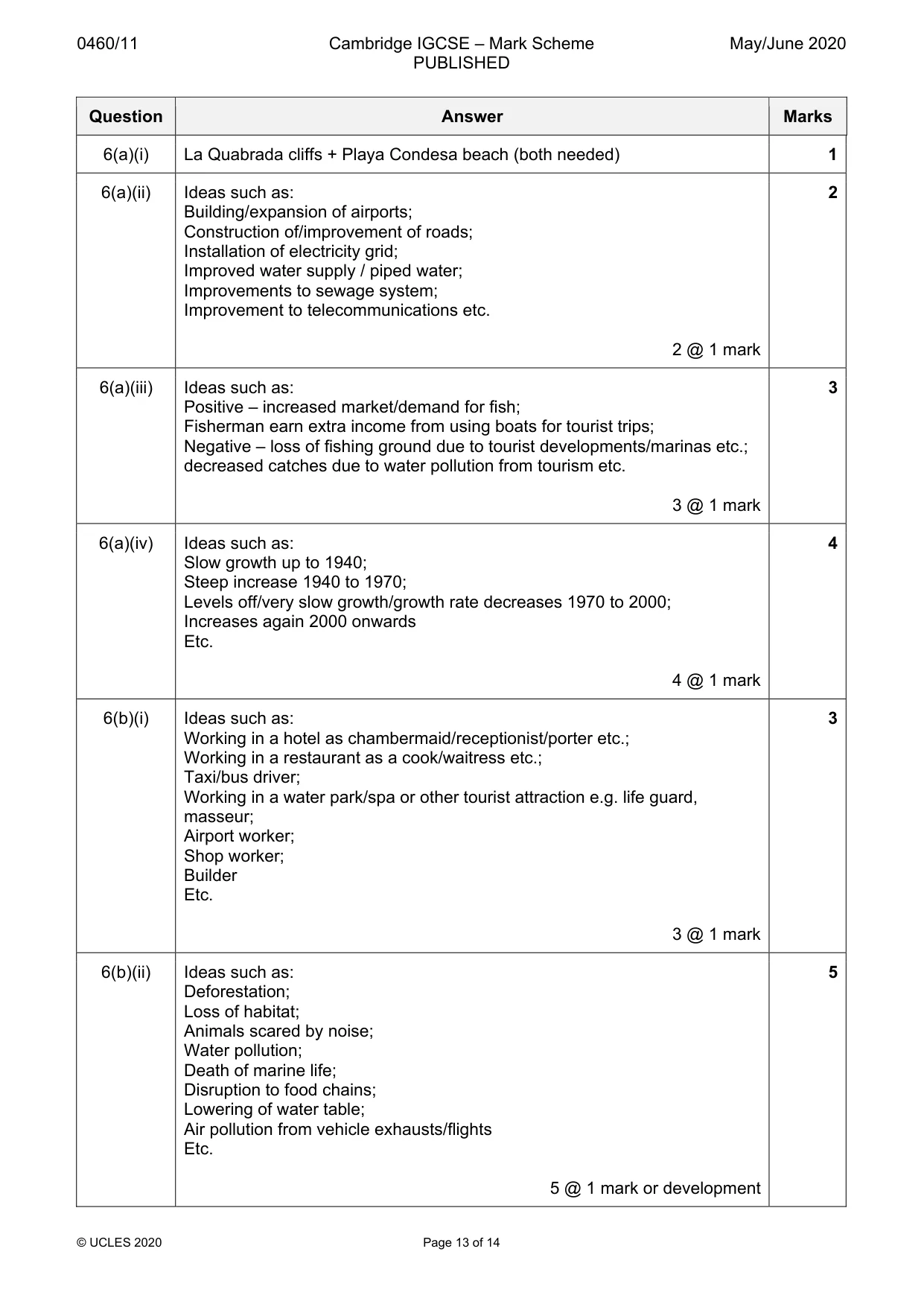
0460/11 Cambridge IGCSE – Mark Scheme PUBLISHED May/June 2020 © UCLES 2020 Page 13 of 14 Question Answer Marks 6(a)(i) La Quabrada cliffs + Playa Condesa beach (both needed) 1 6(a)(ii) Ideas such as: Building/expansion of airports; Construction of/improvement of roads; Installation of electricity grid; Improved water supply / piped water; Improvements to sewage system; Improvement to telecommunications etc. 2 @ 1 mark 2 6(a)(iii) Ideas such as: Positive – increased market/demand for fish; Fisherman earn extra income from using boats for tourist trips; Negative – loss of fishing ground due to tourist developments/marinas etc.; decreased catches due to water pollution from tourism etc. 3 @ 1 mark 3 6(a)(iv) Ideas such as: Slow growth up to 1940; Steep increase 1940 to 1970; Levels off/very slow growth/growth rate decreases 1970 to 2000; Increases again 2000 onwards Etc. 4 @ 1 mark 4 6(b)(i) Ideas such as: Working in a hotel as chambermaid/receptionist/porter etc.; Working in a restaurant as a cook/waitress etc.; Taxi/bus driver; Working in a water park/spa or other tourist attraction e.g. life guard, masseur; Airport worker; Shop worker; Builder Etc. 3 @ 1 mark 3 6(b)(ii) Ideas such as: Deforestation; Loss of habitat; Animals scared by noise; Water pollution; Death of marine life; Disruption to food chains; Lowering of water table; Air pollution from vehicle exhausts/flights Etc. 5 @ 1 mark or development 5
Mark scheme, page 14
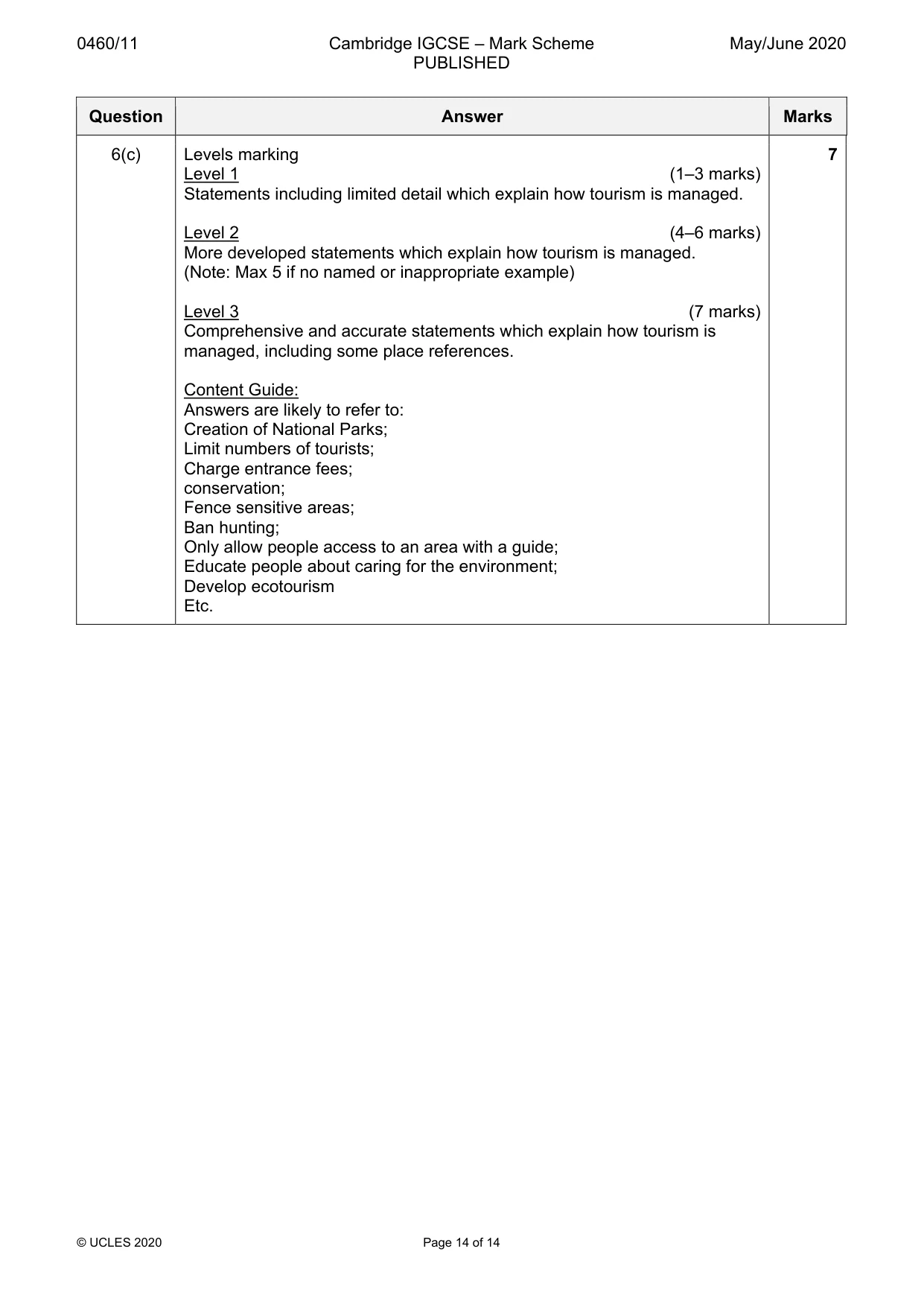
0460/11 Cambridge IGCSE – Mark Scheme PUBLISHED May/June 2020 © UCLES 2020 Page 14 of 14 Question Answer Marks 6(c) Levels marking Level 1 (1–3 marks) Statements including limited detail which explain how tourism is managed. Level 2 (4–6 marks) More developed statements which explain how tourism is managed. (Note: Max 5 if no named or inappropriate example) Level 3 (7 marks) Comprehensive and accurate statements which explain how tourism is managed, including some place references. Content Guide: Answers are likely to refer to: Creation of National Parks; Limit numbers of tourists; Charge entrance fees; conservation; Fence sensitive areas; Ban hunting; Only allow people access to an area with a guide; Educate people about caring for the environment; Develop ecotourism Etc. 7