Cambridge IGCSE Geography 0460 — 2016 Oct/Nov Paper 1 · Variant 1
0460/11/O/N/16 · 75 marks · ≈84 min
The question paper and its mark scheme, free to read here and free to download. This is Cambridge’s own paper, exactly as it was sat.
Question paper28 pages

Mark scheme13 pages
Answers below. Sit the paper first if you are practising.
Paper as text
Question paper, page 1
This document consists of 28 printed pages and 1 Insert. DC (ST/SW) 115393/4 © UCLES 2016 [Turn over Cambridge International Examinations Cambridge International General Certificate of Secondary Education * 0 9 0 9 4 1 1 3 0 5 * GEOGRAPHY 0460/11 Paper 1 October/November 2016 1 hour 45 minutes Candidates answer on the Question Paper. Additional Materials: Ruler Protractor Calculator READ THESE INSTRUCTIONS FIRST Write your Centre number, candidate number and name in the spaces provided. Write in dark blue or black pen. You may use an HB pencil for any diagrams or graphs. Do not use staples, paper clips, glue or correction fluid. DO NOT WRITE IN ANY BARCODES. Write your answer to each question in the space provided. If additional space is required, you should use the lined pages at the end of this booklet. The question number(s) must be clearly shown. Answer three questions, one from each section. The Insert contains Photographs A, B and C for Question 2, Photograph D for Question 4, and Photograph E for Question 6. The Insert is not required by the Examiner. Sketch maps and diagrams should be drawn whenever they serve to illustrate an answer. At the end of the examination, fasten all your work securely together. The number of marks is given in brackets [ ] at the end of each question or part question. Definitions MEDCs – More Economically Developed Countries LEDCs – Less Economically Developed Countries The syllabus is approved for use in England, Wales and Northern Ireland as a Cambridge International Level 1/Level 2 Certificate.
Question paper, page 2
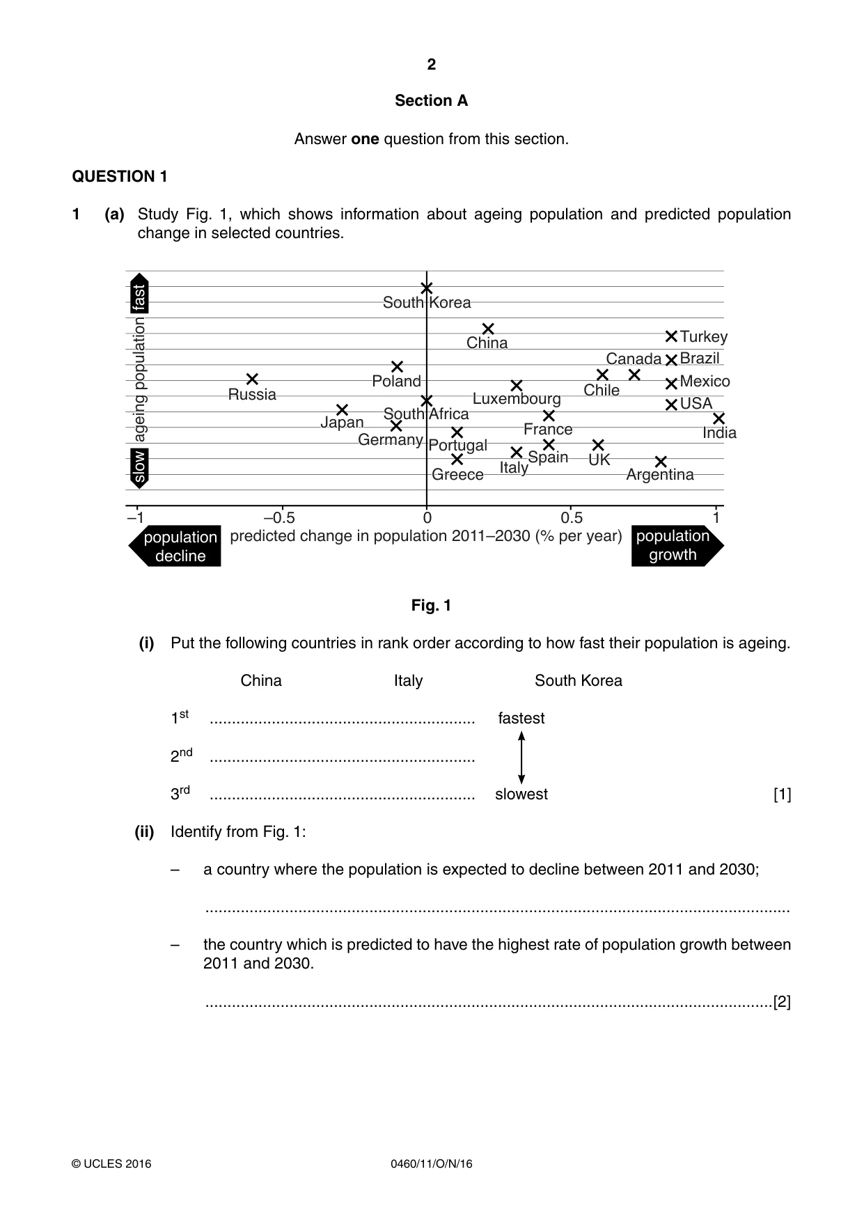
2 0460/11/O/N/16 © UCLES 2016 Section A Answer one question from this section. QUESTION 1 1 (a) Study Fig. 1, which shows information about ageing population and predicted population change in selected countries. –1 –0.5 0.5 1 0 ageing population fast slow predicted change in population 2011–2030 (% per year) population growth population decline South Korea Poland Germany South Africa Luxembourg China Portugal Greece France Spain Italy UK Argentina India Chile Canada Turkey Brazil Mexico USA Russia Japan Fig. 1 (i) Put the following countries in rank order according to how fast their population is ageing. China Italy South Korea 1st … fastest 2nd … 3rd … slowest [1] (ii) Identify from Fig. 1: – a country where the population is expected to decline between 2011 and 2030; … – the country which is predicted to have the highest rate of population growth between 2011 and 2030. …[2]
Question paper, page 3
3 0460/11/O/N/16 © UCLES 2016 [Turn over (iii) One of the reasons why natural population growth rates are high in many countries is because birth rates are high. Give three different reasons why birth rates are high in many LEDCs. 1 … … 2 … … 3 … …[3] (iv) Explain why governments in many LEDCs are trying to reduce rates of population growth. … … … … … … … …[4]
Question paper, page 4
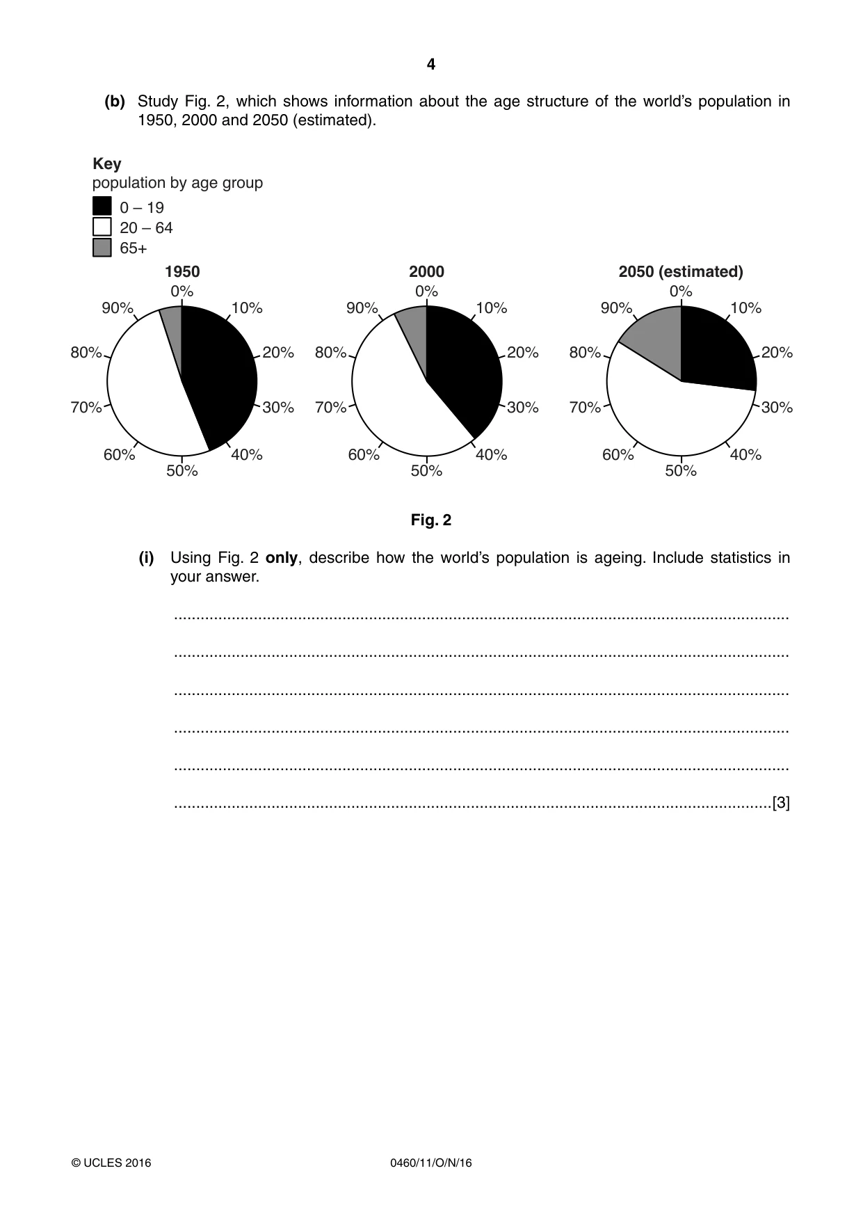
4 0460/11/O/N/16 © UCLES 2016 (b) Study Fig. 2, which shows information about the age structure of the world’s population in 1950, 2000 and 2050 (estimated). 0% 50% 10% 40% 20% 30% 90% 60% 80% 70% 0% 50% 10% 40% 20% 30% 90% 60% 80% 70% 0% 1950 2000 population by age group Key 2050 (estimated) 50% 10% 40% 20% 30% 90% 60% 80% 70% 0 – 19 20 – 64 65+ Fig. 2 (i) Using Fig. 2 only, describe how the world’s population is ageing. Include statistics in your answer. … … … … … …[3]
Question paper, page 5
5 0460/11/O/N/16 © UCLES 2016 [Turn over (ii) Explain why the world’s population is ageing. … … … … … … … … … …[5]
Question paper, page 6
6 0460/11/O/N/16 © UCLES 2016 (c) For a named country you have studied, evaluate the success of its population policy. Name of country … … … … … … … … … … … … … … … … … … … … … … … … … …[7] [Total: 25 marks] END OF QUESTION 1
Question paper, page 7
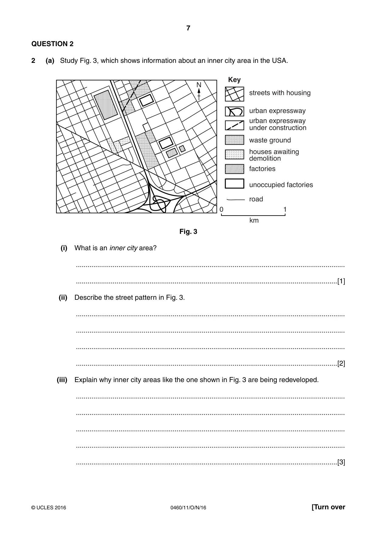
7 0460/11/O/N/16 © UCLES 2016 [Turn over QUESTION 2 2 (a) Study Fig. 3, which shows information about an inner city area in the USA. streets with housing N Key urban expressway urban expressway under construction waste ground houses awaiting demolition factories unoccupied factories road 0 km 1 Fig. 3 (i) What is an inner city area? … …[1] (ii) Describe the street pattern in Fig. 3. … … … …[2] (iii) Explain why inner city areas like the one shown in Fig. 3 are being redeveloped. … … … … …[3]
Question paper, page 8
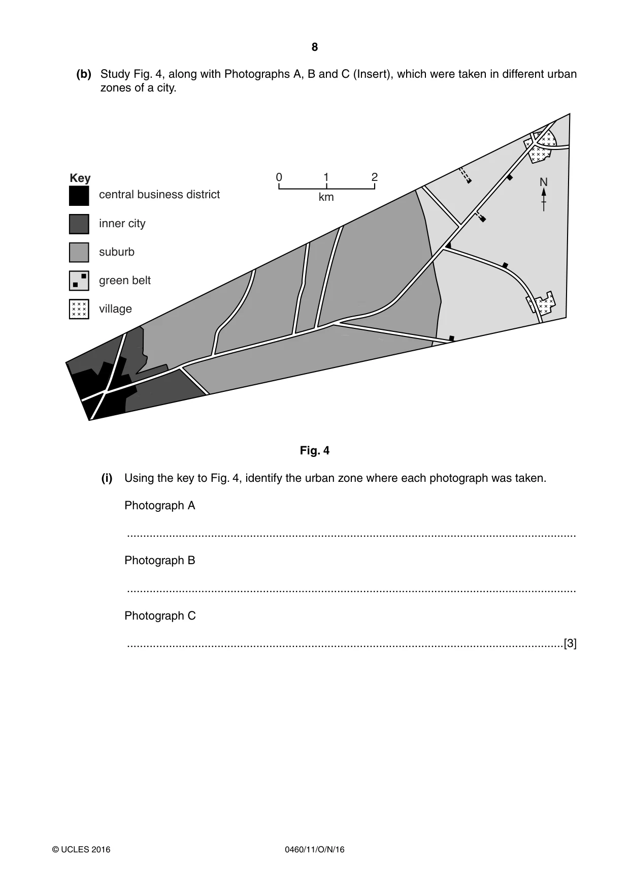
8 0460/11/O/N/16 © UCLES 2016 (b) Study Fig. 4, along with Photographs A, B and C (Insert), which were taken in different urban zones of a city. Key 0 2 1 km central business district inner city suburb green belt village N Fig. 4 (i) Using the key to Fig. 4, identify the urban zone where each photograph was taken. Photograph A … Photograph B … Photograph C …[3]
Question paper, page 9
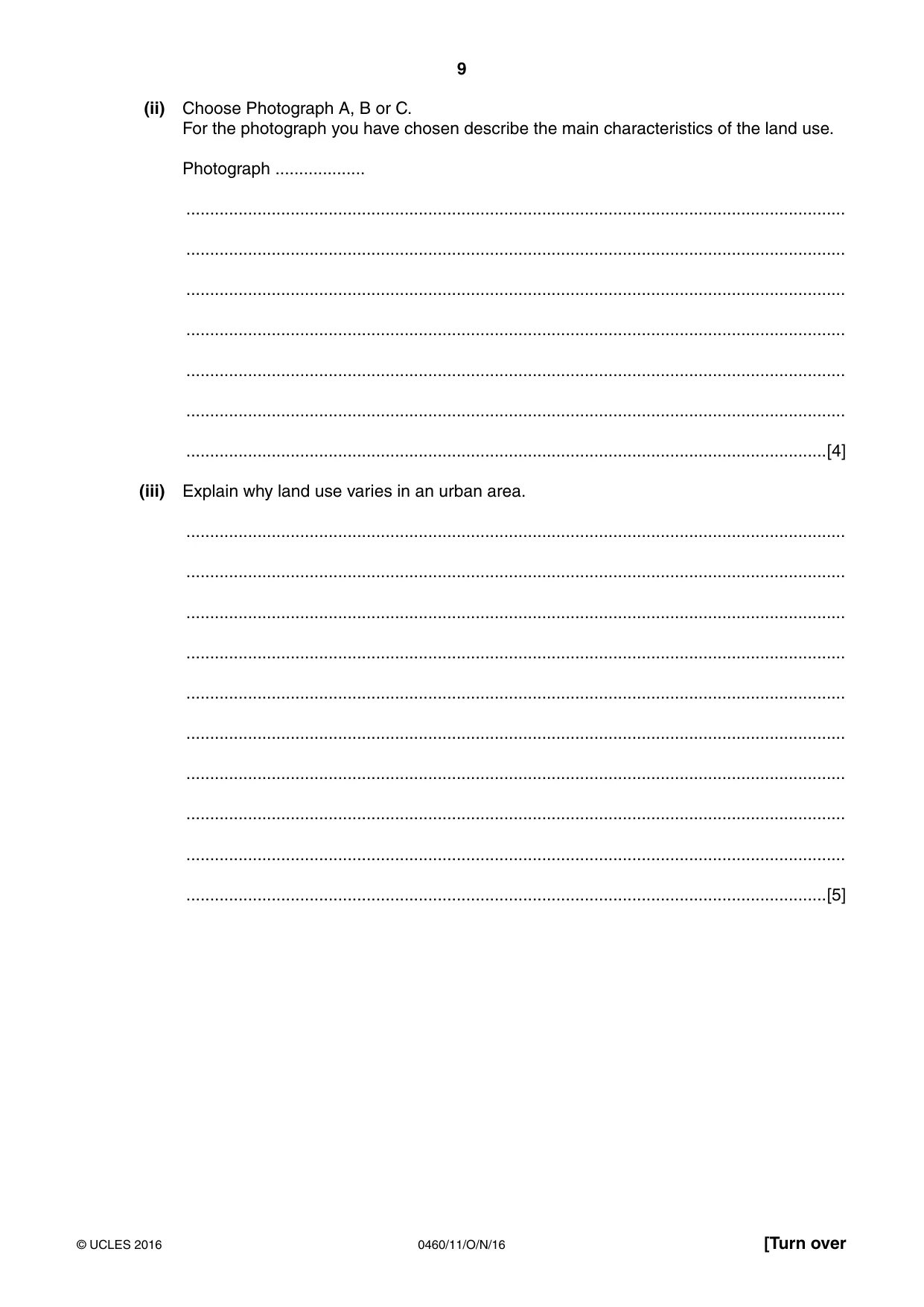
9 0460/11/O/N/16 © UCLES 2016 [Turn over (ii) Choose Photograph A, B or C. For the photograph you have chosen describe the main characteristics of the land use. Photograph … … … … … … … …[4] (iii) Explain why land use varies in an urban area. … … … … … … … … … …[5]
Question paper, page 10
10 0460/11/O/N/16 © UCLES 2016 (c) For a named urban area you have studied, describe the effects of urban sprawl. Name of urban area … … … … … … … … … … … … … … … … … … … … … … … … …[7] [Total: 25 marks] END OF QUESTION 2
Question paper, page 11
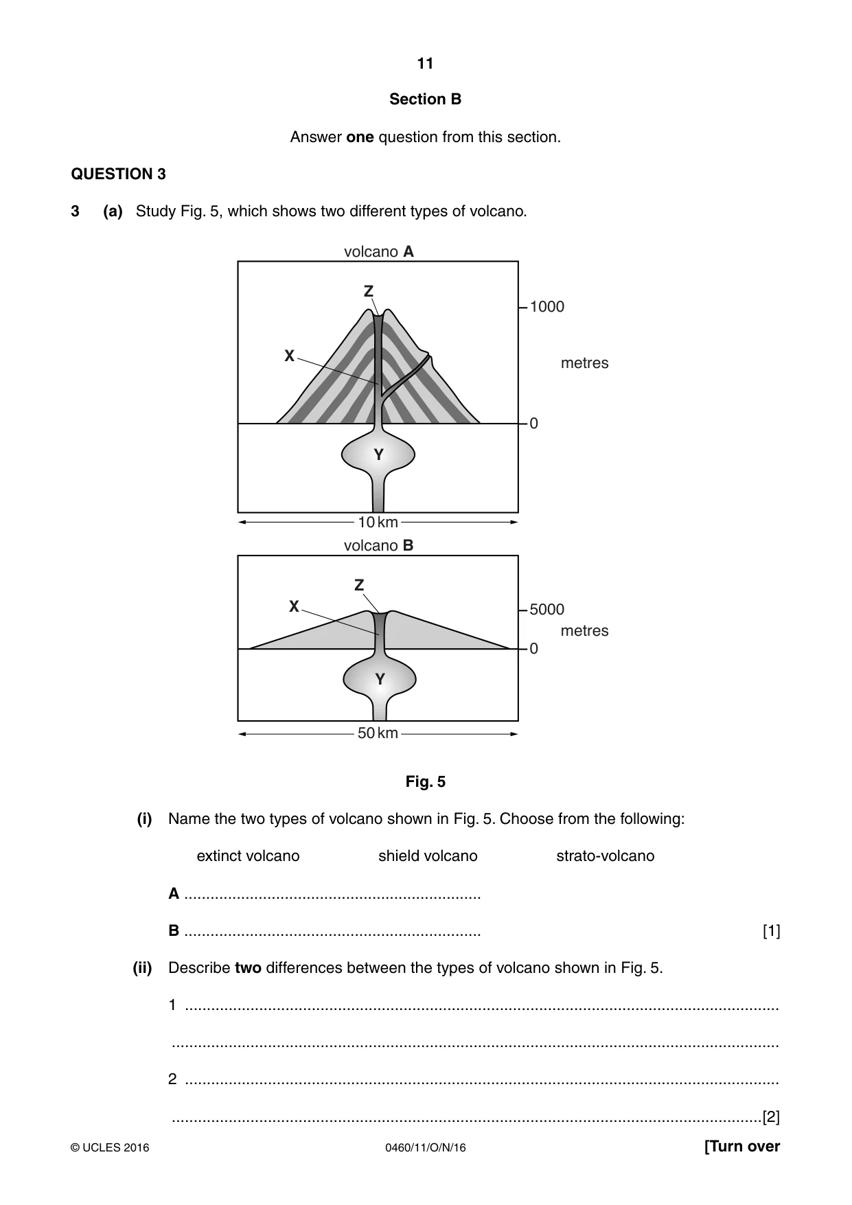
11 0460/11/O/N/16 © UCLES 2016 [Turn over Section B Answer one question from this section. QUESTION 3 3 (a) Study Fig. 5, which shows two different types of volcano. 1000 volcano A volcano B 0 metres 5000 10 km 50 km 0 metres X X Z Z Y Y Fig. 5 (i) Name the two types of volcano shown in Fig. 5. Choose from the following: extinct volcano shield volcano strato-volcano A … B … [1] (ii) Describe two differences between the types of volcano shown in Fig. 5. 1 … … 2 … …[2]
Question paper, page 12
12 0460/11/O/N/16 © UCLES 2016 (iii) Using Fig. 5, identify the features labelled X, Y and Z in the spaces below. X … Y … Z … [3] (iv) Describe the advantages for people of living close to an active volcano. … … … … … … … …[4]
Question paper, page 13
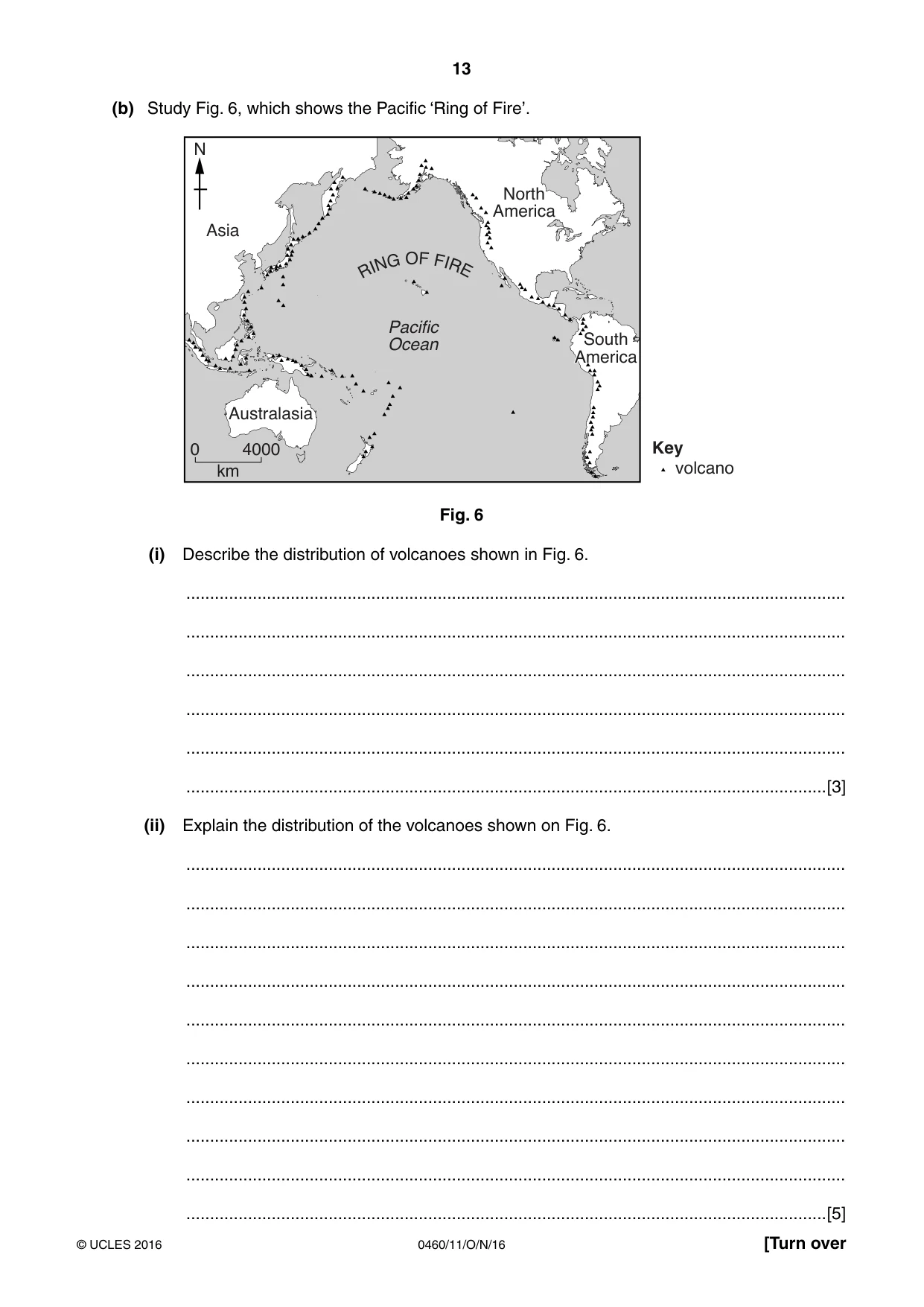
13 0460/11/O/N/16 © UCLES 2016 [Turn over (b) Study Fig. 6, which shows the Pacific ‘Ring of Fire’. 0 4000 Key volcano km Asia N Australasia Pacific Ocean North America South America R I N G O F F I R E Fig. 6 (i) Describe the distribution of volcanoes shown in Fig. 6. … … … … … …[3] (ii) Explain the distribution of the volcanoes shown on Fig. 6. … … … … … … … … … …[5]
Question paper, page 14
14 0460/11/O/N/16 © UCLES 2016 (c) Earthquakes often occur in the same areas as volcanic eruptions. Describe the impacts of an earthquake on a named area you have studied. Name of area … … … … … … … … … … … … … … … … … … … … … … … …[7] [Total: 25 marks] END OF QUESTION 3
Question paper, page 15
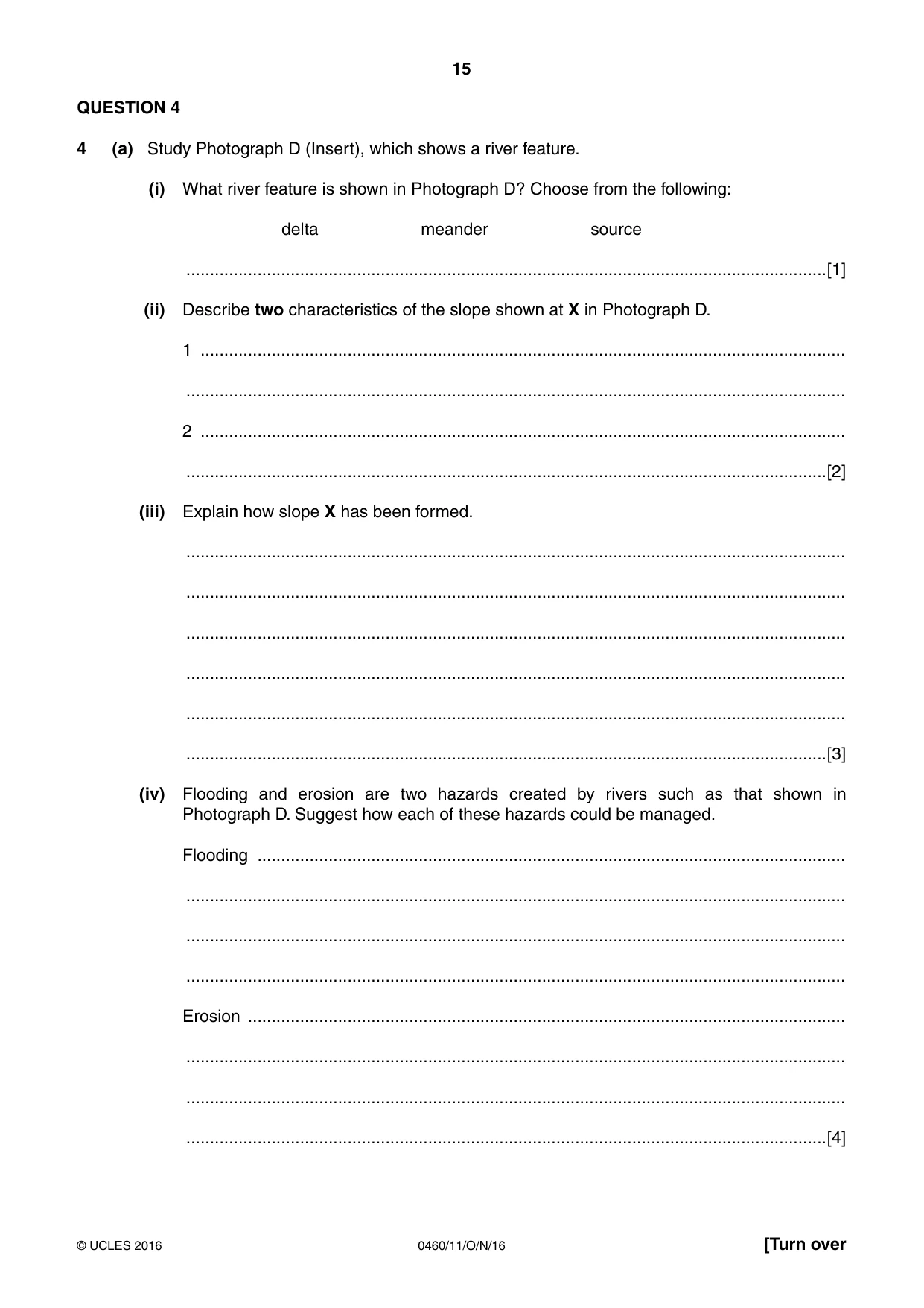
15 0460/11/O/N/16 © UCLES 2016 [Turn over QUESTION 4 4 (a) Study Photograph D (Insert), which shows a river feature. (i) What river feature is shown in Photograph D? Choose from the following: delta meander source …[1] (ii) Describe two characteristics of the slope shown at X in Photograph D. 1 … … 2 … …[2] (iii) Explain how slope X has been formed. … … … … … …[3] (iv) Flooding and erosion are two hazards created by rivers such as that shown in Photograph D. Suggest how each of these hazards could be managed. Flooding … … … … Erosion … … … …[4]
Question paper, page 16
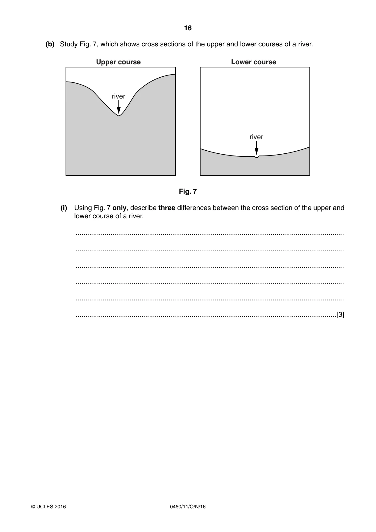
16 0460/11/O/N/16 © UCLES 2016 (b) Study Fig. 7, which shows cross sections of the upper and lower courses of a river. river Upper course Lower course river Fig. 7 (i) Using Fig. 7 only, describe three differences between the cross section of the upper and lower course of a river. … … … … … …[3]
Question paper, page 17
17 0460/11/O/N/16 © UCLES 2016 [Turn over (ii) Explain the formation of a waterfall. You may use labelled diagrams. … … … … … … … … … [5]
Question paper, page 18
18 0460/11/O/N/16 © UCLES 2016 (c) For a named river you have studied, describe the opportunities it provides for people living close to it. Name of river … … … … … … … … … … … … … … … … … … … … … … … … …[7] [Total: 25 marks] END OF QUESTION 4
Question paper, page 19
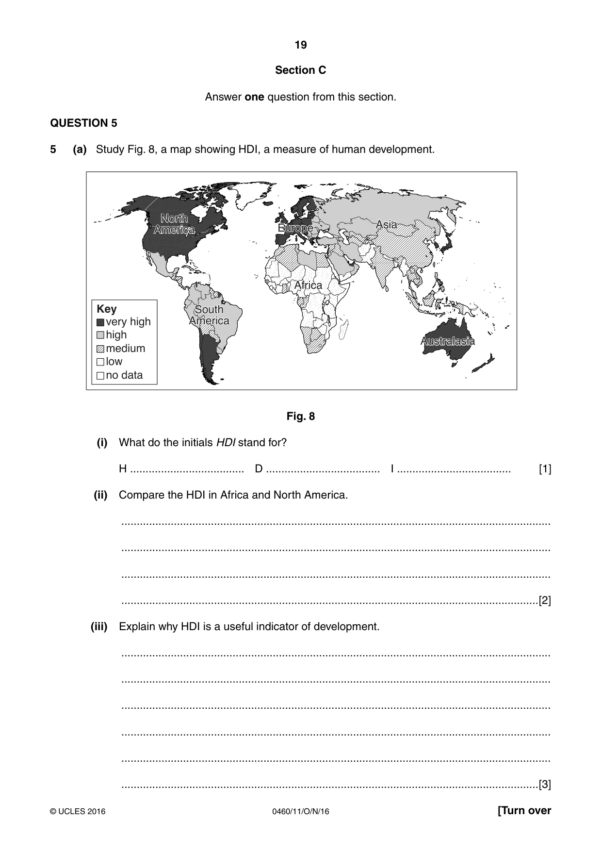
19 0460/11/O/N/16 © UCLES 2016 [Turn over Section C Answer one question from this section. QUESTION 5 5 (a) Study Fig. 8, a map showing HDI, a measure of human development. very high high medium low no data Key North America South America Africa Europe Asia Australasia Fig. 8 (i) What do the initials HDI stand for? H … D … I … [1] (ii) Compare the HDI in Africa and North America. … … … …[2] (iii) Explain why HDI is a useful indicator of development. … … … … … …[3]
Question paper, page 20
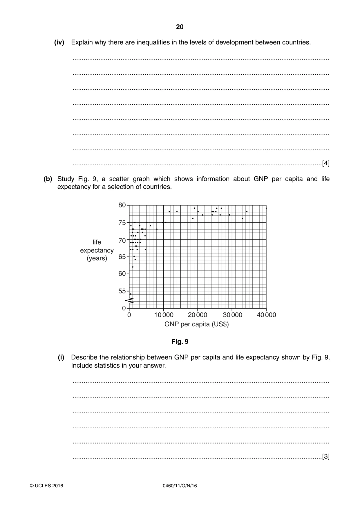
20 0460/11/O/N/16 © UCLES 2016 (iv) Explain why there are inequalities in the levels of development between countries. … … … … … … … …[4] (b) Study Fig. 9, a scatter graph which shows information about GNP per capita and life expectancy for a selection of countries. life expectancy (years) 55 60 65 70 75 80 0 10 000 20 000 GNP per capita (US$) 30 000 40 000 0 Fig. 9 (i) Describe the relationship between GNP per capita and life expectancy shown by Fig. 9. Include statistics in your answer. … … … … … …[3]
Question paper, page 21
21 0460/11/O/N/16 © UCLES 2016 [Turn over (ii) Explain why there is a relationship between GNP per capita and life expectancy. … … … … … … … … … …[5]
Question paper, page 22
22 0460/11/O/N/16 © UCLES 2016 (c) Describe the features of a named transnational corporation you have studied. You should refer to its organisation and global links. Name of transnational corporation … … … … … … … … … … … … … … … … … … … … … … … … …[7] [Total: 25 marks] END OF QUESTION 5
Question paper, page 23
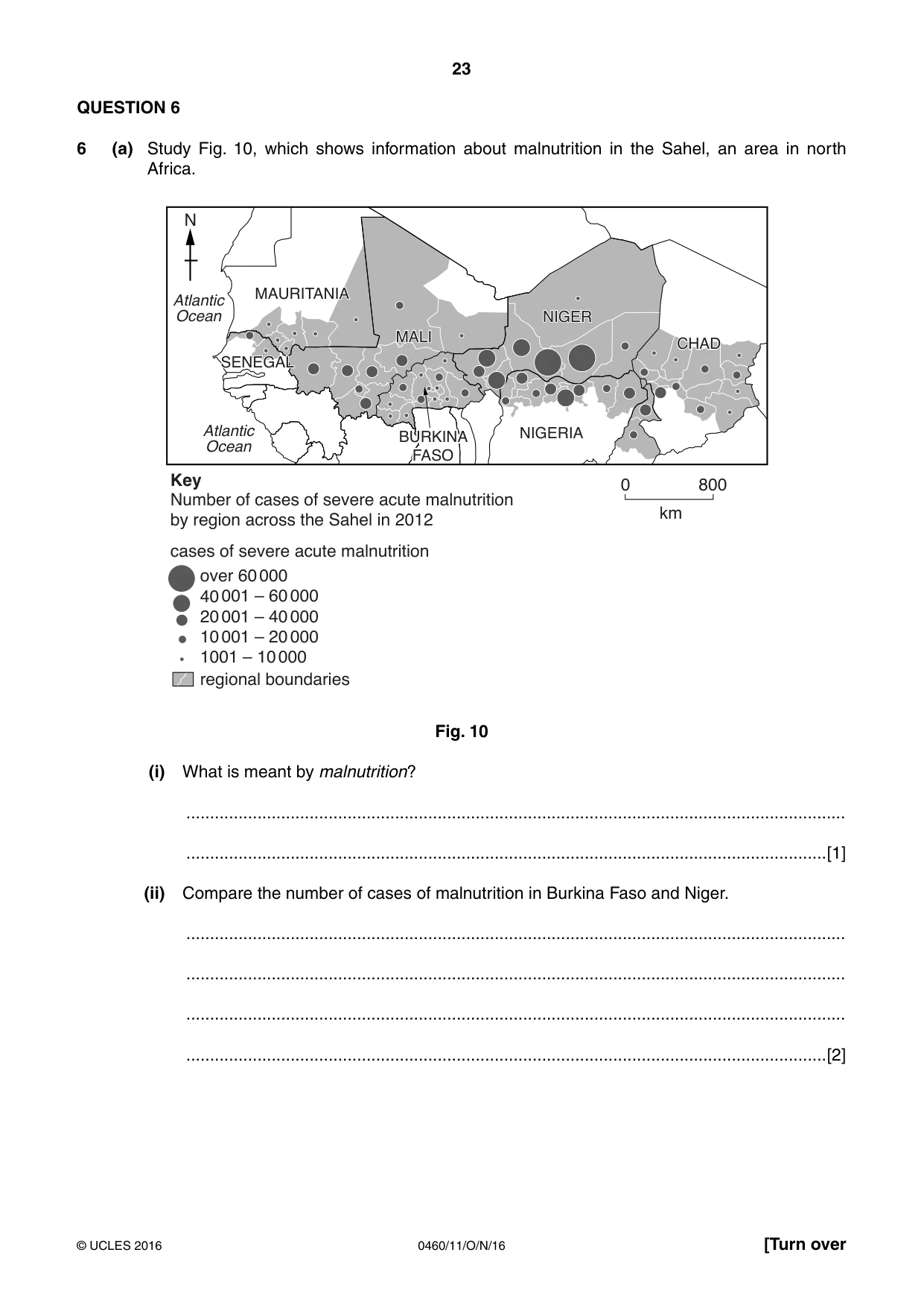
23 0460/11/O/N/16 © UCLES 2016 [Turn over QUESTION 6 6 (a) Study Fig. 10, which shows information about malnutrition in the Sahel, an area in north Africa. over 60 000 40 001 – 60 000 20 001 – 40 000 10 001 – 20 000 1001 – 10 000 regional boundaries cases of severe acute malnutrition Number of cases of severe acute malnutrition by region across the Sahel in 2012 Key 0 800 km N MAURITANIA SENEGAL MALI NIGER CHAD NIGERIA Atlantic Ocean Atlantic Ocean BURKINA FASO Fig. 10 (i) What is meant by malnutrition? … …[1] (ii) Compare the number of cases of malnutrition in Burkina Faso and Niger. … … … …[2]
Question paper, page 24
24 0460/11/O/N/16 © UCLES 2016 (iii) Give three different reasons why countries experience food shortages. 1 … … 2 … … 3 … …[3] (iv) Describe the impacts of food shortages. … … … … … … … …[4]
Question paper, page 25
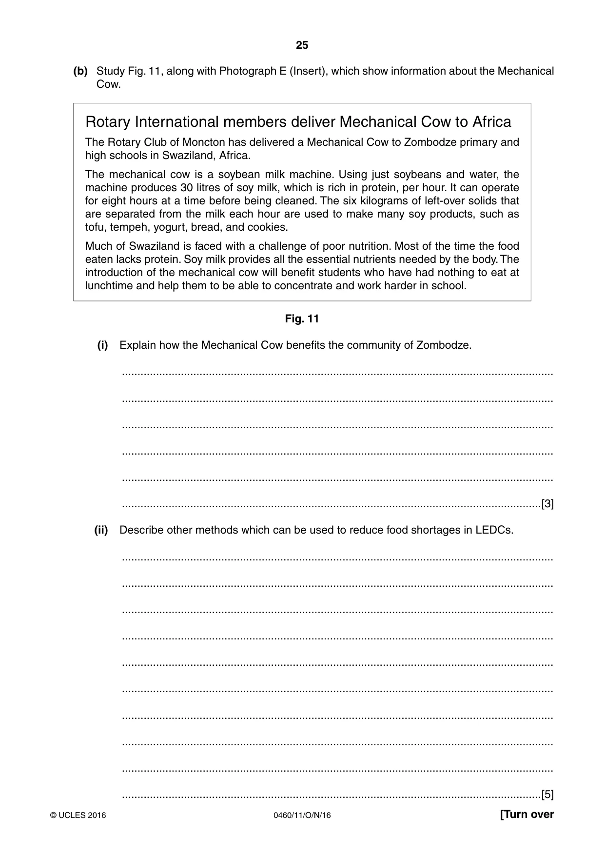
25 0460/11/O/N/16 © UCLES 2016 [Turn over (b) Study Fig. 11, along with Photograph E (Insert), which show information about the Mechanical Cow. Rotary International members deliver Mechanical Cow to Africa The Rotary Club of Moncton has delivered a Mechanical Cow to Zombodze primary and high schools in Swaziland, Africa. The mechanical cow is a soybean milk machine. Using just soybeans and water, the machine produces 30 litres of soy milk, which is rich in protein, per hour. It can operate for eight hours at a time before being cleaned. The six kilograms of left-over solids that are separated from the milk each hour are used to make many soy products, such as tofu, tempeh, yogurt, bread, and cookies. Much of Swaziland is faced with a challenge of poor nutrition. Most of the time the food eaten lacks protein. Soy milk provides all the essential nutrients needed by the body. The introduction of the mechanical cow will benefit students who have had nothing to eat at lunchtime and help them to be able to concentrate and work harder in school. Fig. 11 (i) Explain how the Mechanical Cow benefits the community of Zombodze. … … … … … …[3] (ii) Describe other methods which can be used to reduce food shortages in LEDCs. … … … … … … … … … …[5]
Question paper, page 26
26 0460/11/O/N/16 © UCLES 2016 (c) For an example of a farm or agricultural system at a named location, describe the farming system. Farm or agricultural system … Name of location … … … … … … … … … … … … … … … … … … … … … … … …[7] [Total: 25 marks] END OF QUESTION 6
Question paper, page 27
27 0460/11/O/N/16 © UCLES 2016 Additional Pages If you use the following lined pages to complete the answer(s) to any question(s), the question number(s) must be clearly shown. … … … … … … … … … … … … … … … … … … … … … … … … … …
Question paper, page 28
28 0460/11/O/N/16 © UCLES 2016 Permission to reproduce items where third-party owned material protected by copyright is included has been sought and cleared where possible. Every reasonable effort has been made by the publisher (UCLES) to trace copyright holders, but if any items requiring clearance have unwittingly been included, the publisher will be pleased to make amends at the earliest possible opportunity. To avoid the issue of disclosure of answer-related information to candidates, all copyright acknowledgements are reproduced online in the Cambridge International Examinations Copyright Acknowledgements Booklet. This is produced for each series of examinations and is freely available to download at www.cie.org.uk after the live examination series. Cambridge International Examinations is part of the Cambridge Assessment Group. Cambridge Assessment is the brand name of University of Cambridge Local Examinations Syndicate (UCLES), which is itself a department of the University of Cambridge. … … … … … … … … … … … … … … … … … … … … … … … …
Mark scheme, page 1
® IGCSE is the registered trademark of Cambridge International Examinations. This syllabus is approved for use in England, Wales and Northern Ireland as a Cambridge International Level 1/Level 2 Certificate. This document consists of 13 printed pages. © UCLES 2016 [Turn over Cambridge International Examinations Cambridge International General Certificate of Secondary Education GEOGRAPHY 0460/11 Paper 1 October/November 2016 MARK SCHEME Maximum Mark: 75 Published This mark scheme is published as an aid to teachers and candidates, to indicate the requirements of the examination. It shows the basis on which Examiners were instructed to award marks. It does not indicate the details of the discussions that took place at an Examiners’ meeting before marking began, which would have considered the acceptability of alternative answers. Mark schemes should be read in conjunction with the question paper and the Principal Examiner Report for Teachers. Cambridge will not enter into discussions about these mark schemes. Cambridge is publishing the mark schemes for the October/November 2016 series for most Cambridge IGCSE®, Cambridge International A and AS Level components and some Cambridge O Level components.
Mark scheme, page 2
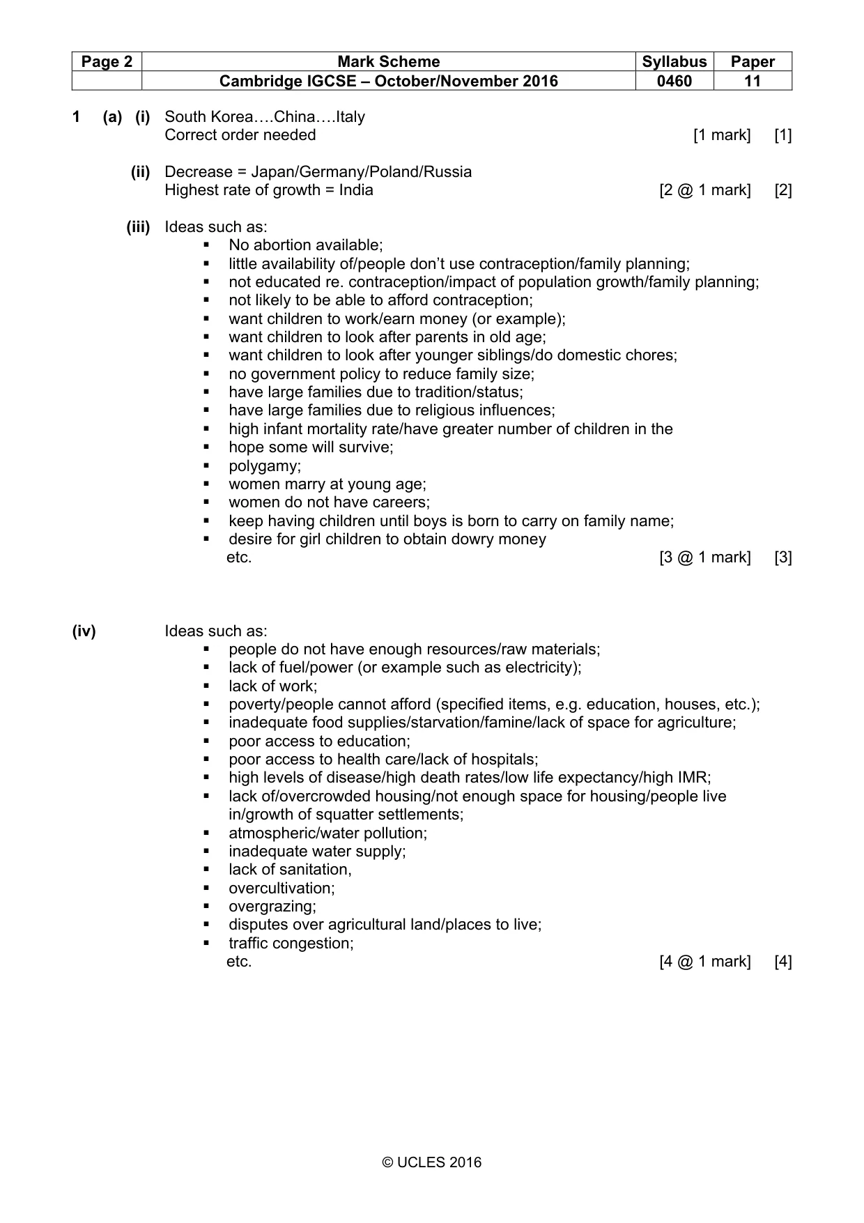
Page 2 Mark Scheme Syllabus Paper Cambridge IGCSE – October/November 2016 0460 11 © UCLES 2016 1 (a) (i) South Korea….China….Italy Correct order needed [1 mark] [1] (ii) Decrease = Japan/Germany/Poland/Russia Highest rate of growth = India [2 @ 1 mark] [2] (iii) Ideas such as: No abortion available; little availability of/people don’t use contraception/family planning; not educated re. contraception/impact of population growth/family planning; not likely to be able to afford contraception; want children to work/earn money (or example); want children to look after parents in old age; want children to look after younger siblings/do domestic chores; no government policy to reduce family size; have large families due to tradition/status; have large families due to religious influences; high infant mortality rate/have greater number of children in the hope some will survive; polygamy; women marry at young age; women do not have careers; keep having children until boys is born to carry on family name; desire for girl children to obtain dowry money etc. [3 @ 1 mark] [3] (iv) Ideas such as: people do not have enough resources/raw materials; lack of fuel/power (or example such as electricity); lack of work; poverty/people cannot afford (specified items, e.g. education, houses, etc.); inadequate food supplies/starvation/famine/lack of space for agriculture; poor access to education; poor access to health care/lack of hospitals; high levels of disease/high death rates/low life expectancy/high IMR; lack of/overcrowded housing/not enough space for housing/people live in/growth of squatter settlements; atmospheric/water pollution; inadequate water supply; lack of sanitation, overcultivation; overgrazing; disputes over agricultural land/places to live; traffic congestion; etc. [4 @ 1 mark] [4]
Mark scheme, page 3
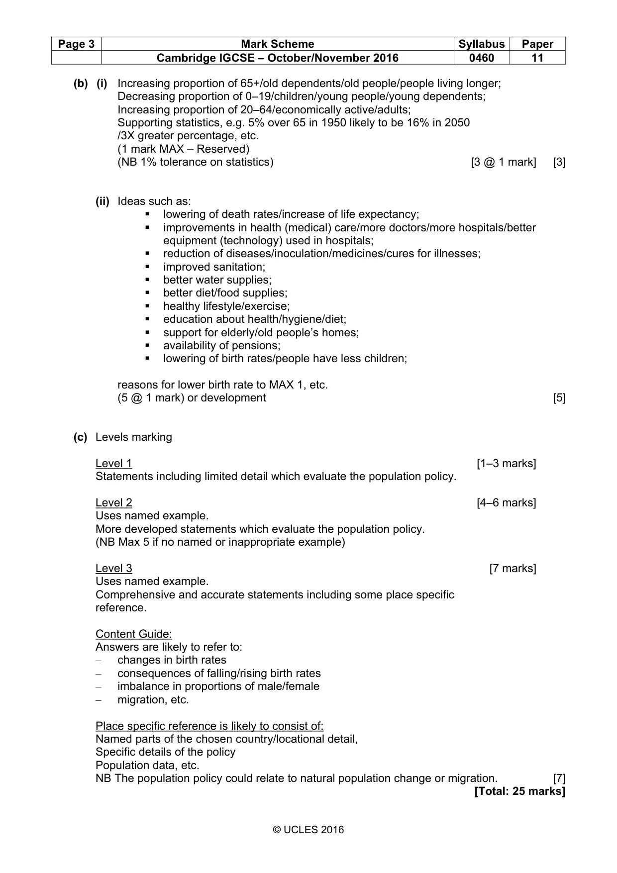
Page 3 Mark Scheme Syllabus Paper Cambridge IGCSE – October/November 2016 0460 11 © UCLES 2016 (b) (i) Increasing proportion of 65+/old dependents/old people/people living longer; Decreasing proportion of 0–19/children/young people/young dependents; Increasing proportion of 20–64/economically active/adults; Supporting statistics, e.g. 5% over 65 in 1950 likely to be 16% in 2050 /3X greater percentage, etc. (1 mark MAX – Reserved) (NB 1% tolerance on statistics) [3 @ 1 mark] [3] (ii) Ideas such as: lowering of death rates/increase of life expectancy; improvements in health (medical) care/more doctors/more hospitals/better equipment (technology) used in hospitals; reduction of diseases/inoculation/medicines/cures for illnesses; improved sanitation; better water supplies; better diet/food supplies; healthy lifestyle/exercise; education about health/hygiene/diet; support for elderly/old people’s homes; availability of pensions; lowering of birth rates/people have less children; reasons for lower birth rate to MAX 1, etc. (5 @ 1 mark) or development [5] (c) Levels marking Level 1 [1–3 marks] Statements including limited detail which evaluate the population policy. Level 2 [4–6 marks] Uses named example. More developed statements which evaluate the population policy. (NB Max 5 if no named or inappropriate example) Level 3 [7 marks] Uses named example. Comprehensive and accurate statements including some place specific reference. Content Guide: Answers are likely to refer to: – changes in birth rates – consequences of falling/rising birth rates – imbalance in proportions of male/female – migration, etc. Place specific reference is likely to consist of: Named parts of the chosen country/locational detail, Specific details of the policy Population data, etc. NB The population policy could relate to natural population change or migration. [7] [Total: 25 marks]
Mark scheme, page 4
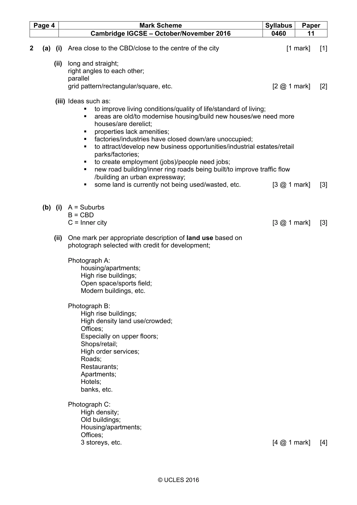
Page 4 Mark Scheme Syllabus Paper Cambridge IGCSE – October/November 2016 0460 11 © UCLES 2016 2 (a) (i) Area close to the CBD/close to the centre of the city [1 mark] [1] (ii) long and straight; right angles to each other; parallel grid pattern/rectangular/square, etc. [2 @ 1 mark] [2] (iii) Ideas such as: to improve living conditions/quality of life/standard of living; areas are old/to modernise housing/build new houses/we need more houses/are derelict; properties lack amenities; factories/industries have closed down/are unoccupied; to attract/develop new business opportunities/industrial estates/retail parks/factories; to create employment (jobs)/people need jobs; new road building/inner ring roads being built/to improve traffic flow /building an urban expressway; some land is currently not being used/wasted, etc. [3 @ 1 mark] [3] (b) (i) A = Suburbs B = CBD C = Inner city [3 @ 1 mark] [3] (ii) One mark per appropriate description of land use based on photograph selected with credit for development; Photograph A: housing/apartments; High rise buildings; Open space/sports field; Modern buildings, etc. Photograph B: High rise buildings; High density land use/crowded; Offices; Especially on upper floors; Shops/retail; High order services; Roads; Restaurants; Apartments; Hotels; banks, etc. Photograph C: High density; Old buildings; Housing/apartments; Offices; 3 storeys, etc. [4 @ 1 mark] [4]
Mark scheme, page 5
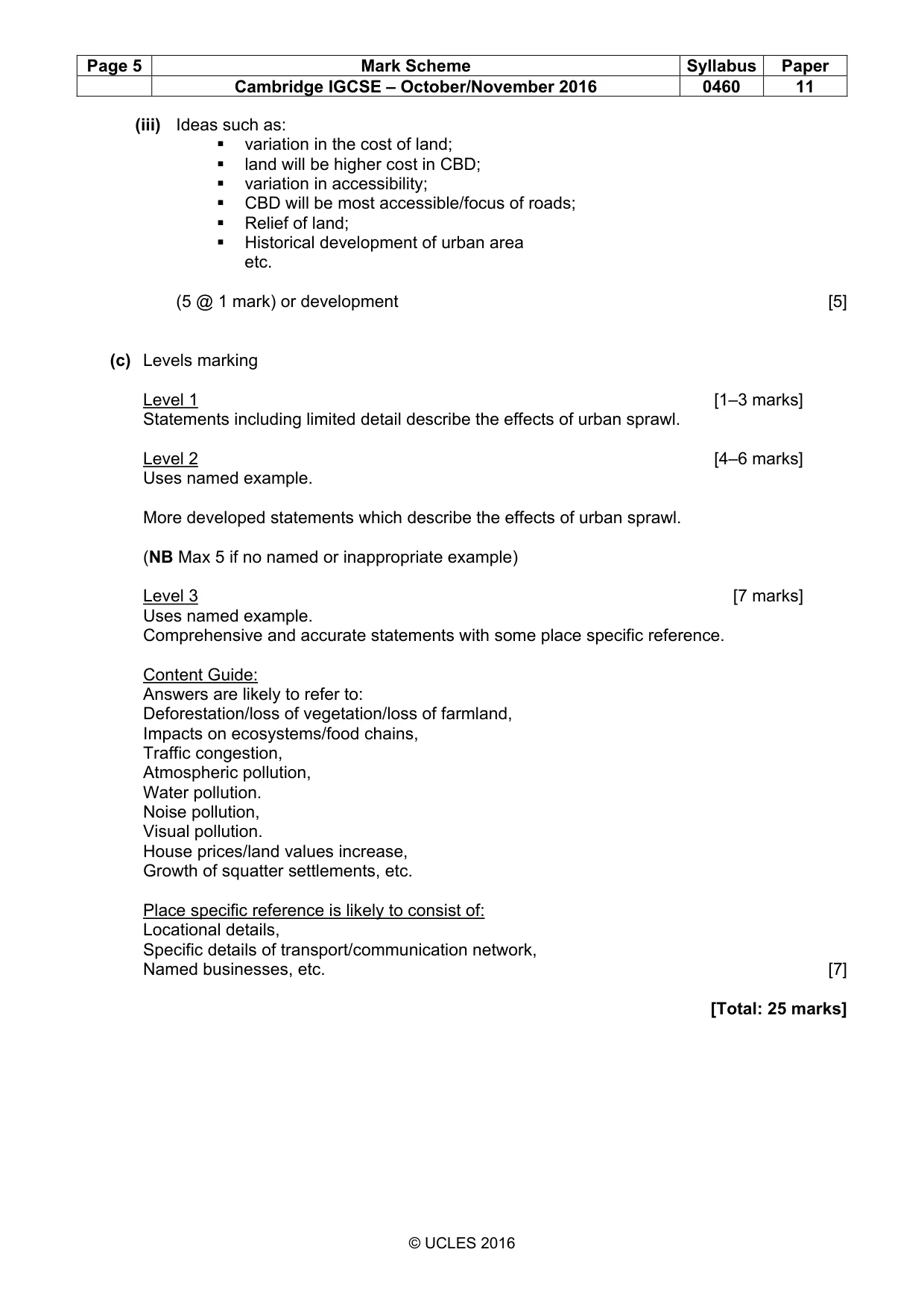
Page 5 Mark Scheme Syllabus Paper Cambridge IGCSE – October/November 2016 0460 11 © UCLES 2016 (iii) Ideas such as: variation in the cost of land; land will be higher cost in CBD; variation in accessibility; CBD will be most accessible/focus of roads; Relief of land; Historical development of urban area etc. (5 @ 1 mark) or development [5] (c) Levels marking Level 1 [1–3 marks] Statements including limited detail describe the effects of urban sprawl. Level 2 [4–6 marks] Uses named example. More developed statements which describe the effects of urban sprawl. (NB Max 5 if no named or inappropriate example) Level 3 [7 marks] Uses named example. Comprehensive and accurate statements with some place specific reference. Content Guide: Answers are likely to refer to: Deforestation/loss of vegetation/loss of farmland, Impacts on ecosystems/food chains, Traffic congestion, Atmospheric pollution, Water pollution. Noise pollution, Visual pollution. House prices/land values increase, Growth of squatter settlements, etc. Place specific reference is likely to consist of: Locational details, Specific details of transport/communication network, Named businesses, etc. [7] [Total: 25 marks]
Mark scheme, page 6
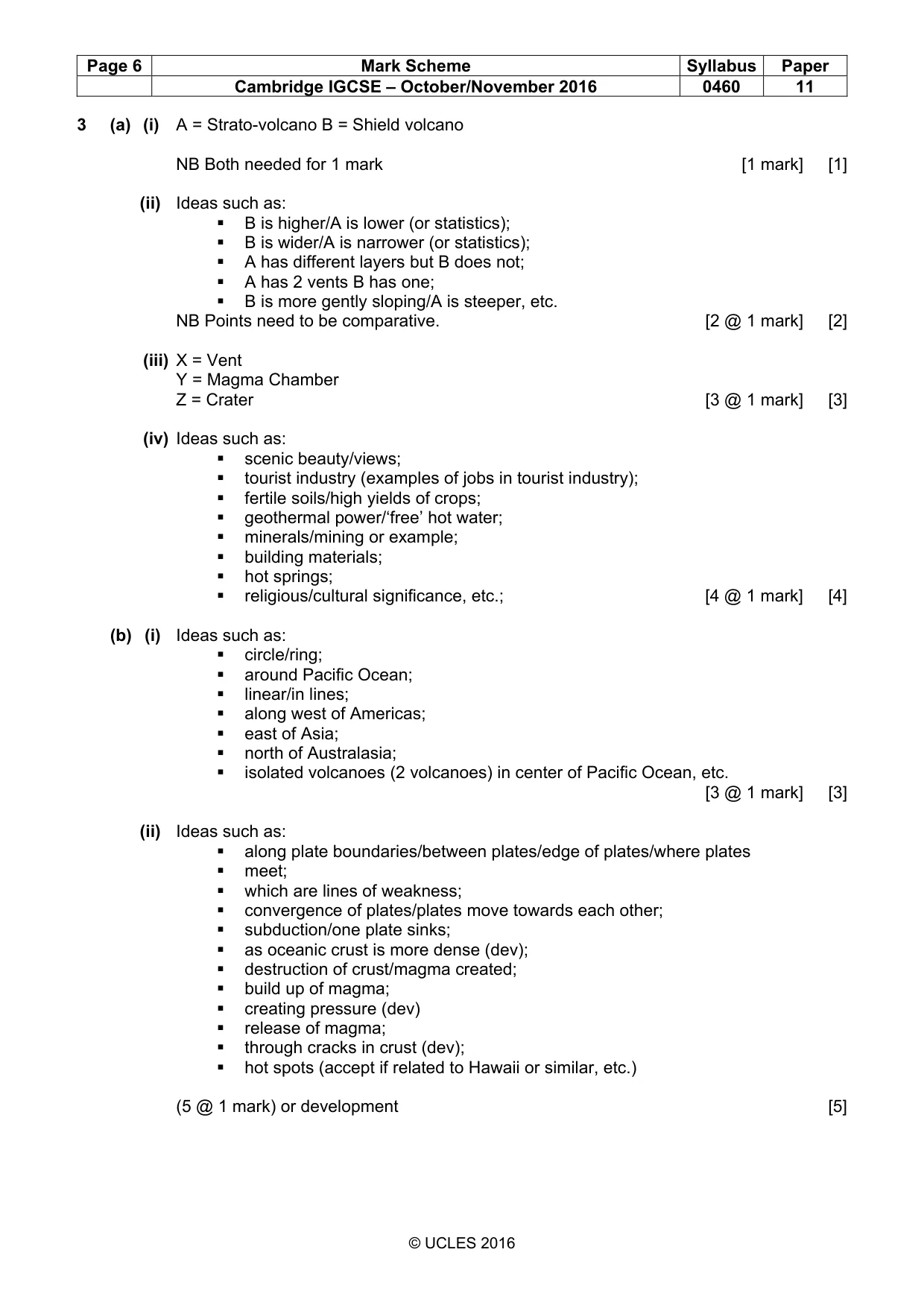
Page 6 Mark Scheme Syllabus Paper Cambridge IGCSE – October/November 2016 0460 11 © UCLES 2016 3 (a) (i) A = Strato-volcano B = Shield volcano NB Both needed for 1 mark [1 mark] [1] (ii) Ideas such as: B is higher/A is lower (or statistics); B is wider/A is narrower (or statistics); A has different layers but B does not; A has 2 vents B has one; B is more gently sloping/A is steeper, etc. NB Points need to be comparative. [2 @ 1 mark] [2] (iii) X = Vent Y = Magma Chamber Z = Crater [3 @ 1 mark] [3] (iv) Ideas such as: scenic beauty/views; tourist industry (examples of jobs in tourist industry); fertile soils/high yields of crops; geothermal power/‘free’ hot water; minerals/mining or example; building materials; hot springs; religious/cultural significance, etc.; [4 @ 1 mark] [4] (b) (i) Ideas such as: circle/ring; around Pacific Ocean; linear/in lines; along west of Americas; east of Asia; north of Australasia; isolated volcanoes (2 volcanoes) in center of Pacific Ocean, etc. [3 @ 1 mark] [3] (ii) Ideas such as: along plate boundaries/between plates/edge of plates/where plates meet; which are lines of weakness; convergence of plates/plates move towards each other; subduction/one plate sinks; as oceanic crust is more dense (dev); destruction of crust/magma created; build up of magma; creating pressure (dev) release of magma; through cracks in crust (dev); hot spots (accept if related to Hawaii or similar, etc.) (5 @ 1 mark) or development [5]
Mark scheme, page 7
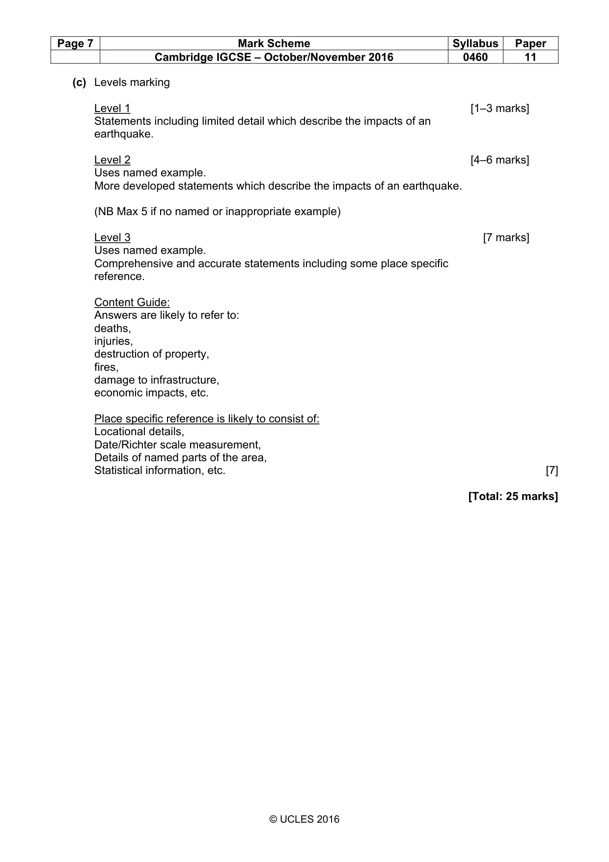
Page 7 Mark Scheme Syllabus Paper Cambridge IGCSE – October/November 2016 0460 11 © UCLES 2016 (c) Levels marking Level 1 [1–3 marks] Statements including limited detail which describe the impacts of an earthquake. Level 2 [4–6 marks] Uses named example. More developed statements which describe the impacts of an earthquake. (NB Max 5 if no named or inappropriate example) Level 3 [7 marks] Uses named example. Comprehensive and accurate statements including some place specific reference. Content Guide: Answers are likely to refer to: deaths, injuries, destruction of property, fires, damage to infrastructure, economic impacts, etc. Place specific reference is likely to consist of: Locational details, Date/Richter scale measurement, Details of named parts of the area, Statistical information, etc. [7] [Total: 25 marks]
Mark scheme, page 8
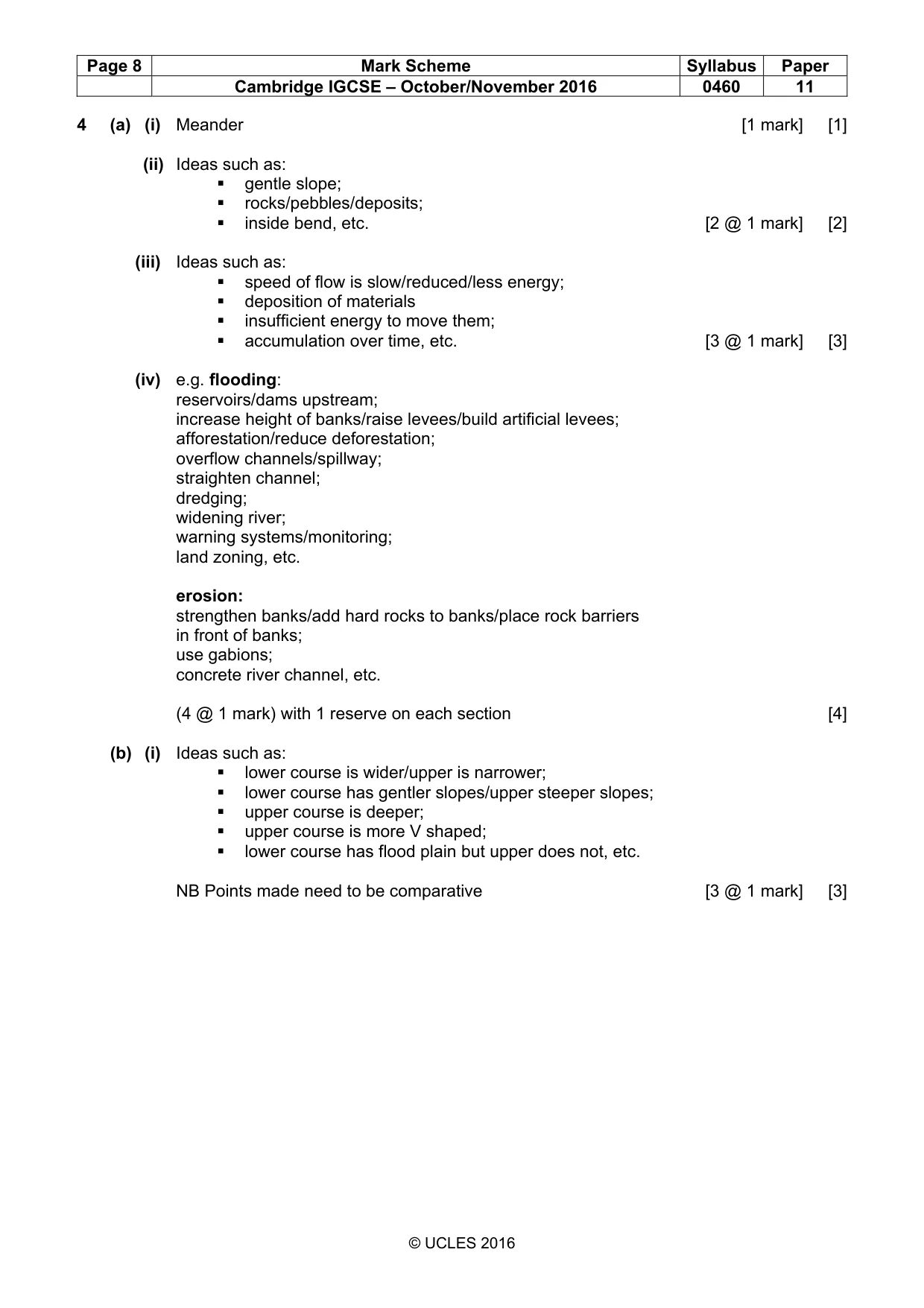
Page 8 Mark Scheme Syllabus Paper Cambridge IGCSE – October/November 2016 0460 11 © UCLES 2016 4 (a) (i) Meander [1 mark] [1] (ii) Ideas such as: gentle slope; rocks/pebbles/deposits; inside bend, etc. [2 @ 1 mark] [2] (iii) Ideas such as: speed of flow is slow/reduced/less energy; deposition of materials insufficient energy to move them; accumulation over time, etc. [3 @ 1 mark] [3] (iv) e.g. flooding: reservoirs/dams upstream; increase height of banks/raise levees/build artificial levees; afforestation/reduce deforestation; overflow channels/spillway; straighten channel; dredging; widening river; warning systems/monitoring; land zoning, etc. erosion: strengthen banks/add hard rocks to banks/place rock barriers in front of banks; use gabions; concrete river channel, etc. (4 @ 1 mark) with 1 reserve on each section [4] (b) (i) Ideas such as: lower course is wider/upper is narrower; lower course has gentler slopes/upper steeper slopes; upper course is deeper; upper course is more V shaped; lower course has flood plain but upper does not, etc. NB Points made need to be comparative [3 @ 1 mark] [3]
Mark scheme, page 9
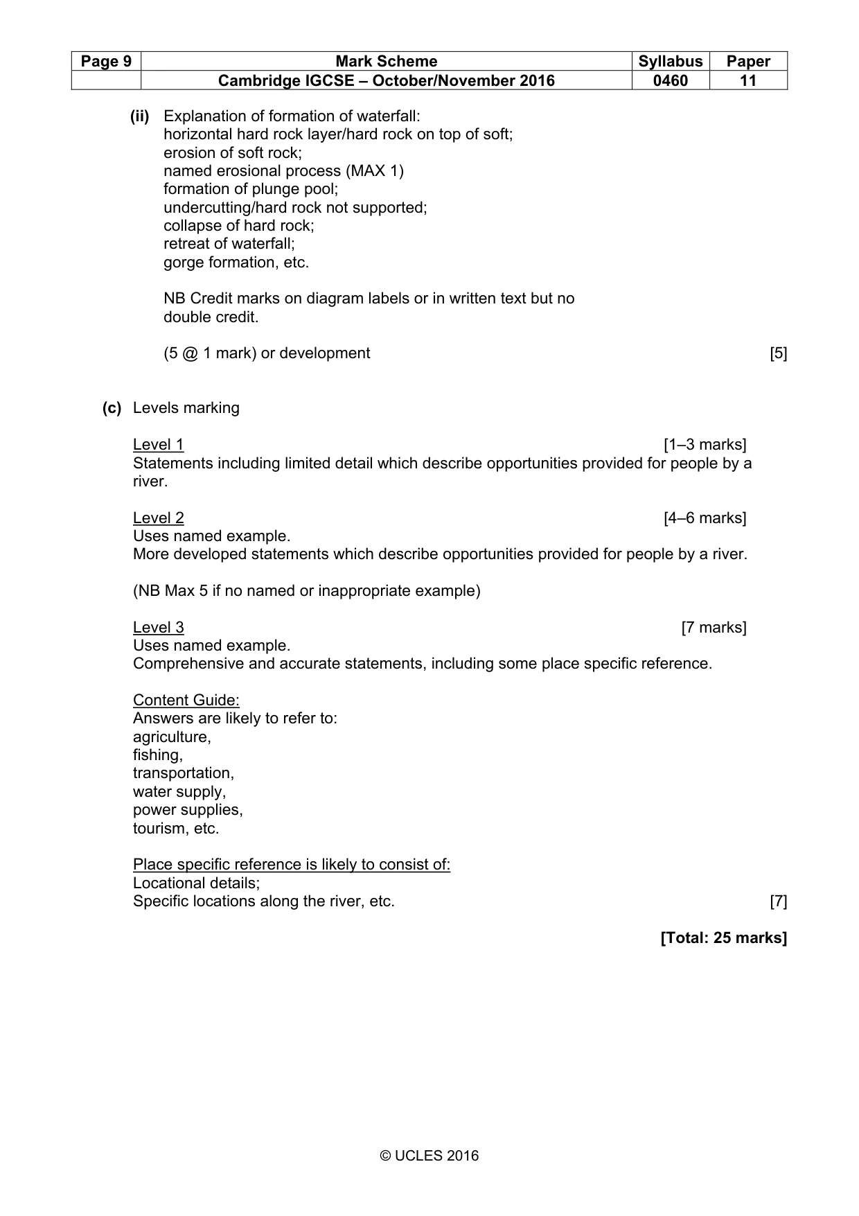
Page 9 Mark Scheme Syllabus Paper Cambridge IGCSE – October/November 2016 0460 11 © UCLES 2016 (ii) Explanation of formation of waterfall: horizontal hard rock layer/hard rock on top of soft; erosion of soft rock; named erosional process (MAX 1) formation of plunge pool; undercutting/hard rock not supported; collapse of hard rock; retreat of waterfall; gorge formation, etc. NB Credit marks on diagram labels or in written text but no double credit. (5 @ 1 mark) or development [5] (c) Levels marking Level 1 [1–3 marks] Statements including limited detail which describe opportunities provided for people by a river. Level 2 [4–6 marks] Uses named example. More developed statements which describe opportunities provided for people by a river. (NB Max 5 if no named or inappropriate example) Level 3 [7 marks] Uses named example. Comprehensive and accurate statements, including some place specific reference. Content Guide: Answers are likely to refer to: agriculture, fishing, transportation, water supply, power supplies, tourism, etc. Place specific reference is likely to consist of: Locational details; Specific locations along the river, etc. [7] [Total: 25 marks]
Mark scheme, page 10
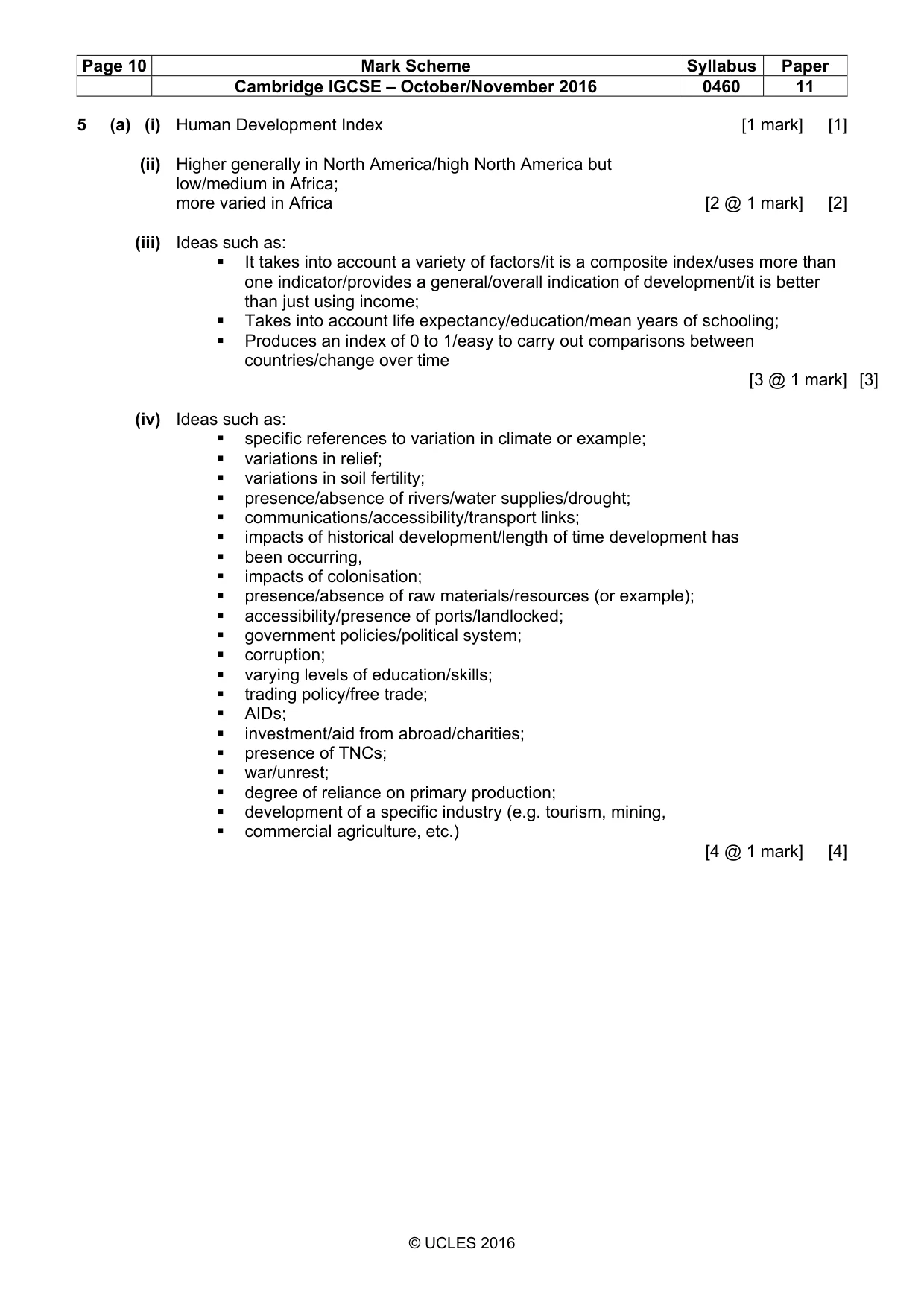
Page 10 Mark Scheme Syllabus Paper Cambridge IGCSE – October/November 2016 0460 11 © UCLES 2016 5 (a) (i) Human Development Index [1 mark] [1] (ii) Higher generally in North America/high North America but low/medium in Africa; more varied in Africa [2 @ 1 mark] [2] (iii) Ideas such as: It takes into account a variety of factors/it is a composite index/uses more than one indicator/provides a general/overall indication of development/it is better than just using income; Takes into account life expectancy/education/mean years of schooling; Produces an index of 0 to 1/easy to carry out comparisons between countries/change over time [3 @ 1 mark] [3] (iv) Ideas such as: specific references to variation in climate or example; variations in relief; variations in soil fertility; presence/absence of rivers/water supplies/drought; communications/accessibility/transport links; impacts of historical development/length of time development has been occurring, impacts of colonisation; presence/absence of raw materials/resources (or example); accessibility/presence of ports/landlocked; government policies/political system; corruption; varying levels of education/skills; trading policy/free trade; AIDs; investment/aid from abroad/charities; presence of TNCs; war/unrest; degree of reliance on primary production; development of a specific industry (e.g. tourism, mining, commercial agriculture, etc.) [4 @ 1 mark] [4]
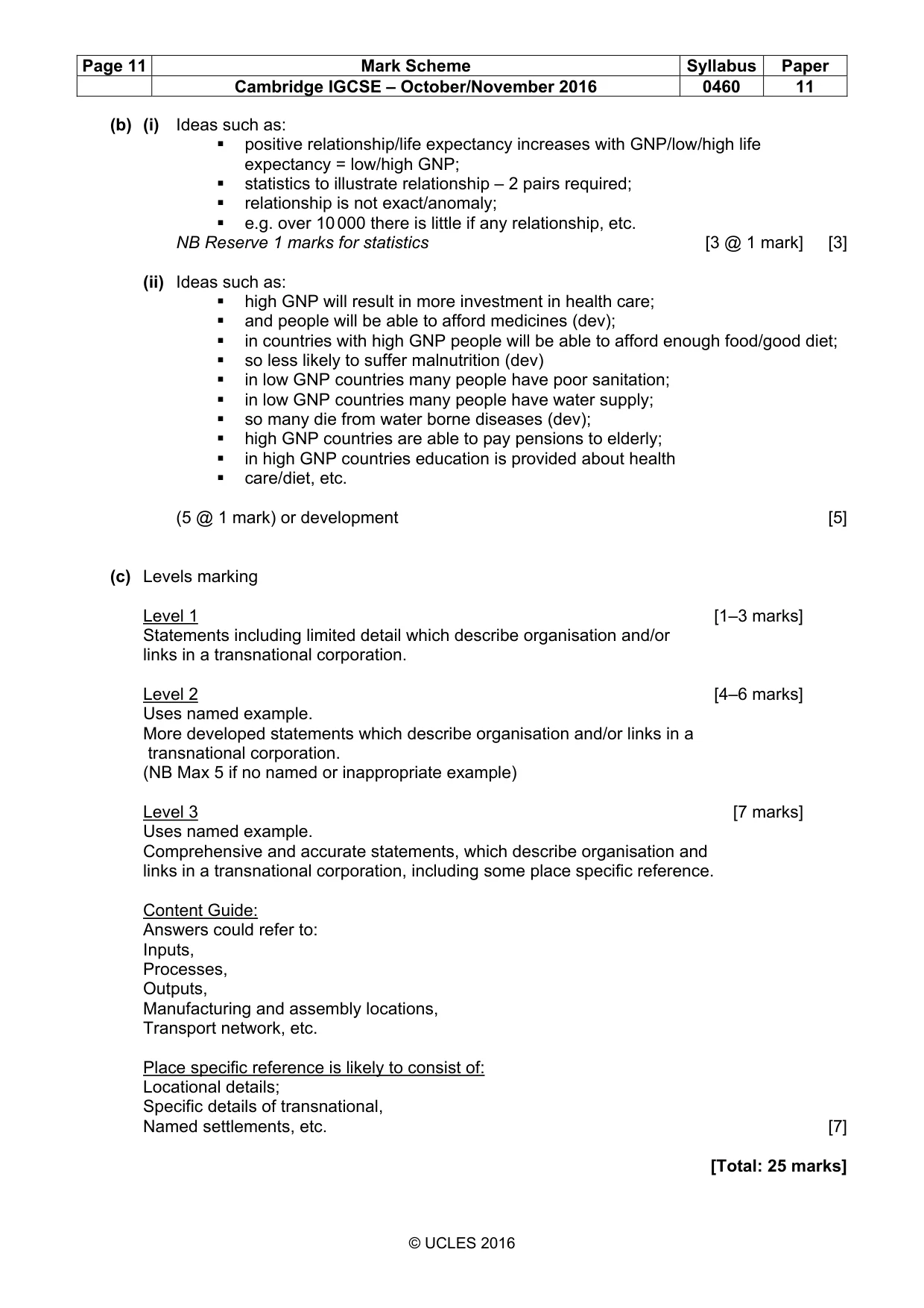
Mark scheme, page 11
Page 11 Mark Scheme Syllabus Paper Cambridge IGCSE – October/November 2016 0460 11 © UCLES 2016 (b) (i) Ideas such as: positive relationship/life expectancy increases with GNP/low/high life expectancy = low/high GNP; statistics to illustrate relationship – 2 pairs required; relationship is not exact/anomaly; e.g. over 10 000 there is little if any relationship, etc. NB Reserve 1 marks for statistics [3 @ 1 mark] [3] (ii) Ideas such as: high GNP will result in more investment in health care; and people will be able to afford medicines (dev); in countries with high GNP people will be able to afford enough food/good diet; so less likely to suffer malnutrition (dev) in low GNP countries many people have poor sanitation; in low GNP countries many people have water supply; so many die from water borne diseases (dev); high GNP countries are able to pay pensions to elderly; in high GNP countries education is provided about health care/diet, etc. (5 @ 1 mark) or development [5] (c) Levels marking Level 1 [1–3 marks] Statements including limited detail which describe organisation and/or links in a transnational corporation. Level 2 [4–6 marks] Uses named example. More developed statements which describe organisation and/or links in a transnational corporation. (NB Max 5 if no named or inappropriate example) Level 3 [7 marks] Uses named example. Comprehensive and accurate statements, which describe organisation and links in a transnational corporation, including some place specific reference. Content Guide: Answers could refer to: Inputs, Processes, Outputs, Manufacturing and assembly locations, Transport network, etc. Place specific reference is likely to consist of: Locational details; Specific details of transnational, Named settlements, etc. [7] [Total: 25 marks]
Mark scheme, page 12
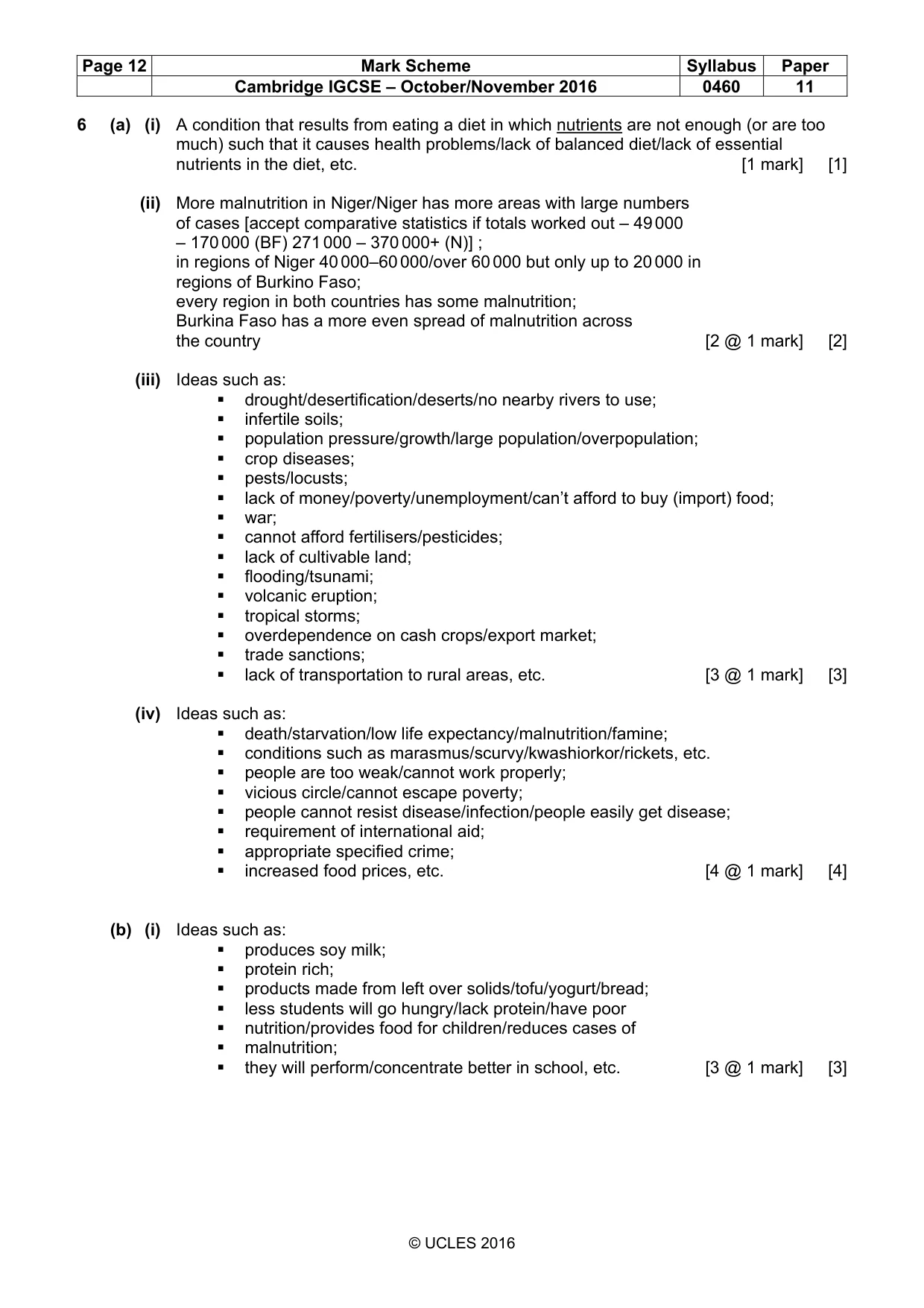
Page 12 Mark Scheme Syllabus Paper Cambridge IGCSE – October/November 2016 0460 11 © UCLES 2016 6 (a) (i) A condition that results from eating a diet in which nutrients are not enough (or are too much) such that it causes health problems/lack of balanced diet/lack of essential nutrients in the diet, etc. [1 mark] [1] (ii) More malnutrition in Niger/Niger has more areas with large numbers of cases [accept comparative statistics if totals worked out – 49 000 – 170 000 (BF) 271 000 – 370 000+ (N)] ; in regions of Niger 40 000–60 000/over 60 000 but only up to 20 000 in regions of Burkino Faso; every region in both countries has some malnutrition; Burkina Faso has a more even spread of malnutrition across the country [2 @ 1 mark] [2] (iii) Ideas such as: drought/desertification/deserts/no nearby rivers to use; infertile soils; population pressure/growth/large population/overpopulation; crop diseases; pests/locusts; lack of money/poverty/unemployment/can’t afford to buy (import) food; war; cannot afford fertilisers/pesticides; lack of cultivable land; flooding/tsunami; volcanic eruption; tropical storms; overdependence on cash crops/export market; trade sanctions; lack of transportation to rural areas, etc. [3 @ 1 mark] [3] (iv) Ideas such as: death/starvation/low life expectancy/malnutrition/famine; conditions such as marasmus/scurvy/kwashiorkor/rickets, etc. people are too weak/cannot work properly; vicious circle/cannot escape poverty; people cannot resist disease/infection/people easily get disease; requirement of international aid; appropriate specified crime; increased food prices, etc. [4 @ 1 mark] [4] (b) (i) Ideas such as: produces soy milk; protein rich; products made from left over solids/tofu/yogurt/bread; less students will go hungry/lack protein/have poor nutrition/provides food for children/reduces cases of malnutrition; they will perform/concentrate better in school, etc. [3 @ 1 mark] [3]
Mark scheme, page 13
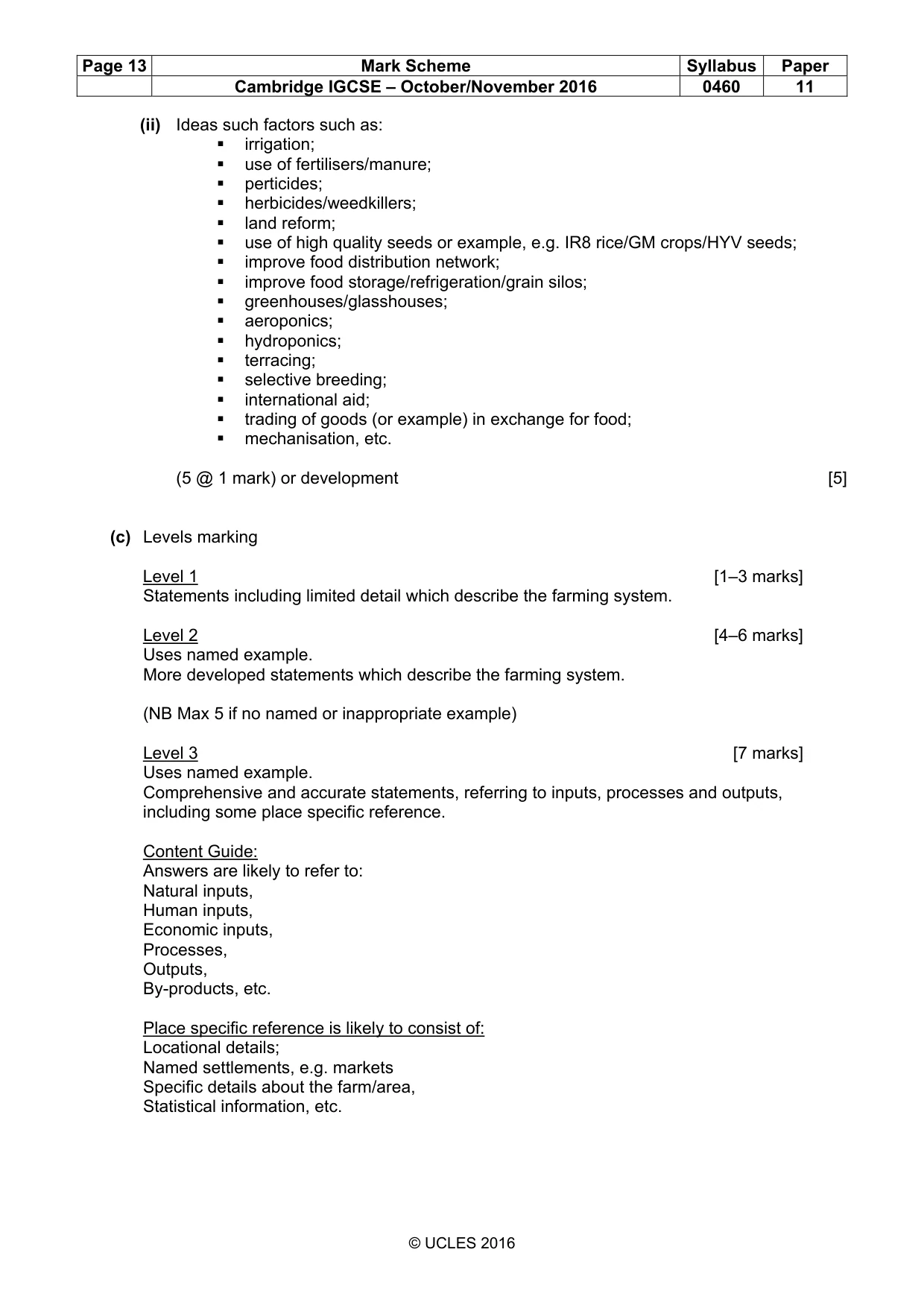
Page 13 Mark Scheme Syllabus Paper Cambridge IGCSE – October/November 2016 0460 11 © UCLES 2016 (ii) Ideas such factors such as: irrigation; use of fertilisers/manure; perticides; herbicides/weedkillers; land reform; use of high quality seeds or example, e.g. IR8 rice/GM crops/HYV seeds; improve food distribution network; improve food storage/refrigeration/grain silos; greenhouses/glasshouses; aeroponics; hydroponics; terracing; selective breeding; international aid; trading of goods (or example) in exchange for food; mechanisation, etc. (5 @ 1 mark) or development [5] (c) Levels marking Level 1 [1–3 marks] Statements including limited detail which describe the farming system. Level 2 [4–6 marks] Uses named example. More developed statements which describe the farming system. (NB Max 5 if no named or inappropriate example) Level 3 [7 marks] Uses named example. Comprehensive and accurate statements, referring to inputs, processes and outputs, including some place specific reference. Content Guide: Answers are likely to refer to: Natural inputs, Human inputs, Economic inputs, Processes, Outputs, By-products, etc. Place specific reference is likely to consist of: Locational details; Named settlements, e.g. markets Specific details about the farm/area, Statistical information, etc.
What you needed in this session
Cambridge’s own grade thresholds for 2016 Oct/Nov, Paper 1 · Variant 1. A higher threshold means an easier paper — the bar moves with how the cohort did.