Cambridge IGCSE Environmental Management 0680 — 2013 Oct/Nov Paper 1 · Variant 2
0680/12/O/N/13 · 60 marks · ≈68 min
The question paper and its mark scheme, free to read here and free to download. This is Cambridge’s own paper, exactly as it was sat.
Question paper16 pages



Mark scheme4 pages
Answers below. Sit the paper first if you are practising.
Paper as text
Question paper, page 1
This document consists of 13 printed pages and 3 blank pages. DC (CW/CGW) 67400/4 © UCLES 2013 [Turn over UNIVERSITY OF CAMBRIDGE INTERNATIONAL EXAMINATIONS International General Certificate of Secondary Education * 7 9 8 3 2 3 9 8 2 8 * ENVIRONMENTAL MANAGEMENT 0680/12 Paper 1 October/November 2013 1 hour 30 minutes Candidates answer on the Question Paper. Additional Materials: Ruler READ THESE INSTRUCTIONS FIRST Write your Centre number, candidate number and name on all the work you hand in. Write in dark blue or black pen. You may use a soft pencil for any diagrams, graphs or rough working. Do not use staples, paper clips, highlighters, glue or correction fluid. DO NOT WRITE IN ANY BARCODES. Answer all questions. Electronic calculators may be used. You may lose marks if you do not show your working or if you do not use appropriate units. At the end of the examination, fasten all your work securely together. The number of marks is given in brackets [ ] at the end of each question or part question. For Examiner’s Use 1 2 3 4 5 6 Total
Question paper, page 2
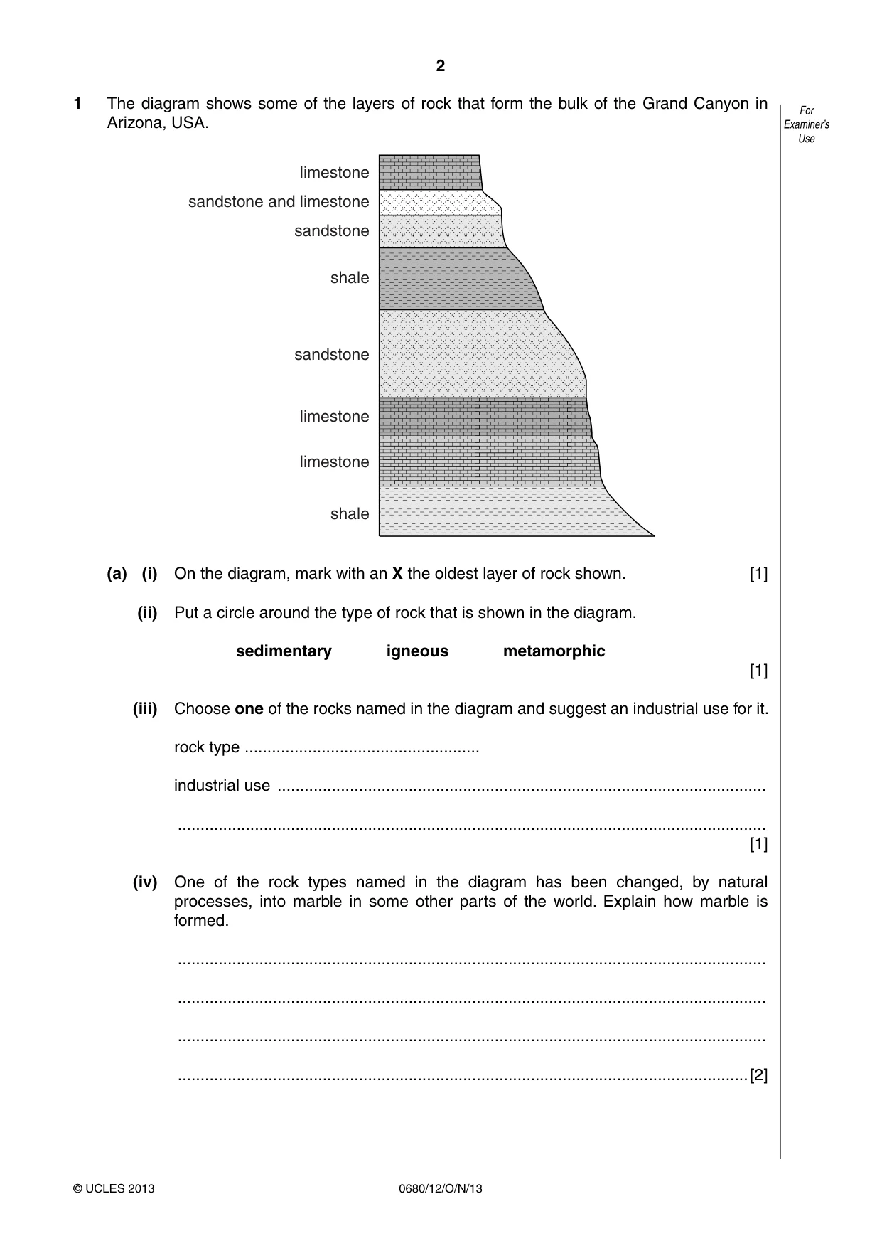
2 0680/12/O/N/13 © UCLES 2013 For Examiner’s Use 1 The diagram shows some of the layers of rock that form the bulk of the Grand Canyon in Arizona, USA. shale shale sandstone sandstone sandstone and limestone limestone limestone limestone (a) (i) On the diagram, mark with an X the oldest layer of rock shown. [1] (ii) Put a circle around the type of rock that is shown in the diagram. sedimentary igneous metamorphic [1] (iii) Choose one of the rocks named in the diagram and suggest an industrial use for it. rock type … industrial use … … [1] (iv) One of the rock types named in the diagram has been changed, by natural processes, into marble in some other parts of the world. Explain how marble is formed. … … … …[2]
Question paper, page 3
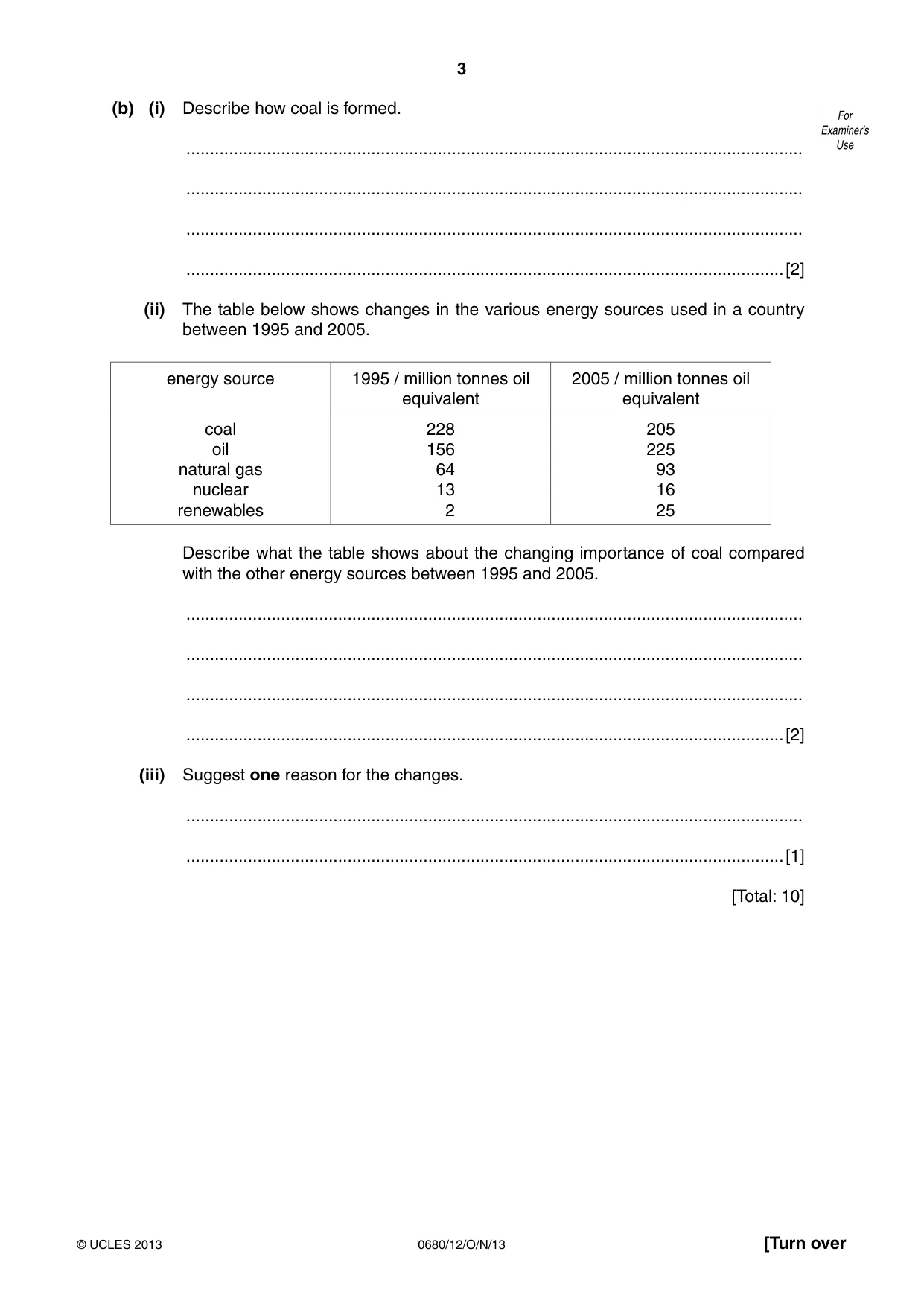
3 0680/12/O/N/13 © UCLES 2013 [Turn over For Examiner’s Use (b) (i) Describe how coal is formed. … … … …[2] (ii) The table below shows changes in the various energy sources used in a country between 1995 and 2005. energy source 1995 / million tonnes oil equivalent 2005 / million tonnes oil equivalent coal oil natural gas nuclear renewables 228 156 64 13 2 205 225 93 16 25 Describe what the table shows about the changing importance of coal compared with the other energy sources between 1995 and 2005. … … … …[2] (iii) Suggest one reason for the changes. … …[1] [Total: 10]
Question paper, page 4
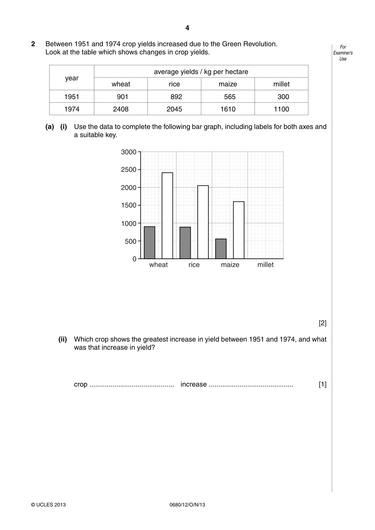
4 0680/12/O/N/13 © UCLES 2013 For Examiner’s Use 2 Between 1951 and 1974 crop yields increased due to the Green Revolution. Look at the table which shows changes in crop yields. year average yields / kg per hectare wheat rice maize millet 1951 901 892 565 300 1974 2408 2045 1610 1100 (a) (i) Use the data to complete the following bar graph, including labels for both axes and a suitable key. 3000 2500 2000 1500 wheat rice maize 1000 500 0 millet [2] (ii) Which crop shows the greatest increase in yield between 1951 and 1974, and what was that increase in yield? crop … increase … [1]
Question paper, page 5
5 0680/12/O/N/13 © UCLES 2013 [Turn over For Examiner’s Use (b) Suggest what changes in agriculture and farming practice have led to these increased crop yields. … … … … … …[3] (c) Describe and explain problems for farmers in achieving these high yields. … … … … … … … …[4] [Total: 10]
Question paper, page 6
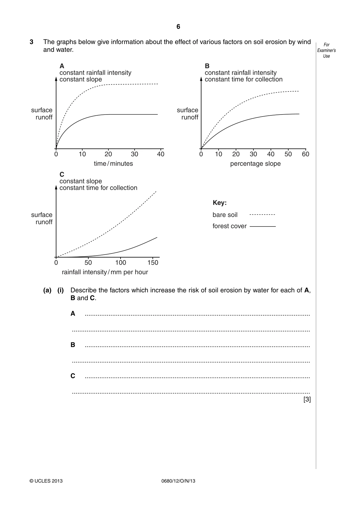
6 0680/12/O/N/13 © UCLES 2013 For Examiner’s Use 3 The graphs below give information about the effect of various factors on soil erosion by wind and water. surface runoff surface runoff B constant rainfall intensity constant time for collection A constant rainfall intensity constant slope C constant slope constant time for collection 10 20 time / minutes rainfall intensity / mm per hour Key: bare soil forest cover percentage slope 0 0 30 40 50 100 150 10 20 0 30 40 50 60 surface runoff (a) (i) Describe the factors which increase the risk of soil erosion by water for each of A, B and C. A … … B … … C … … [3]
Question paper, page 7
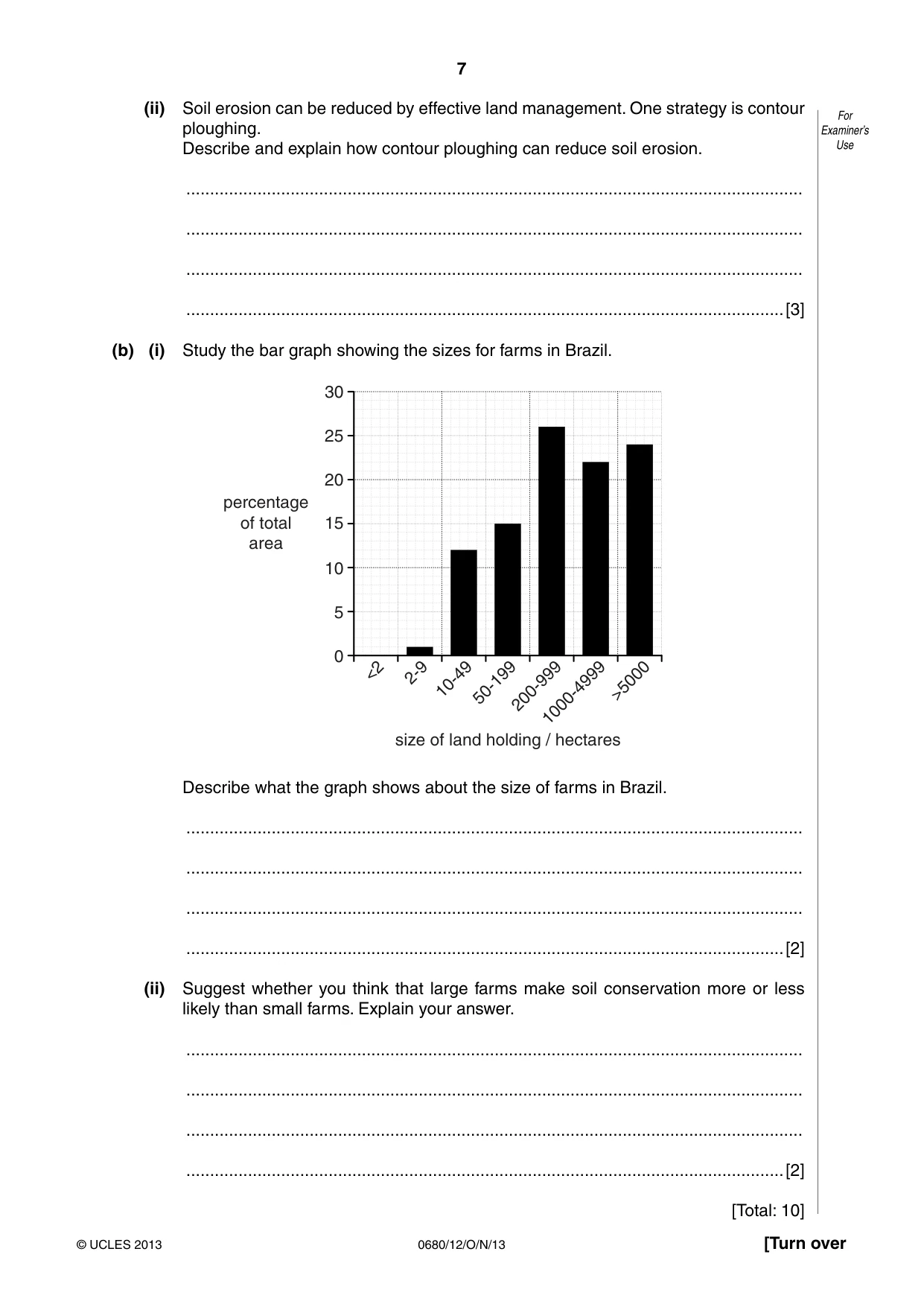
7 0680/12/O/N/13 © UCLES 2013 [Turn over For Examiner’s Use (ii) Soil erosion can be reduced by effective land management. One strategy is contour ploughing. Describe and explain how contour ploughing can reduce soil erosion. … … … …[3] (b) (i) Study the bar graph showing the sizes for farms in Brazil. 30 25 20 15 size of land holding / hectares percentage of total area <2 2-9 10-49 50-199 200-999 1000-4999 >5000 10 5 0 Describe what the graph shows about the size of farms in Brazil. … … … …[2] (ii) Suggest whether you think that large farms make soil conservation more or less likely than small farms. Explain your answer. … … … …[2] [Total: 10]
Question paper, page 8
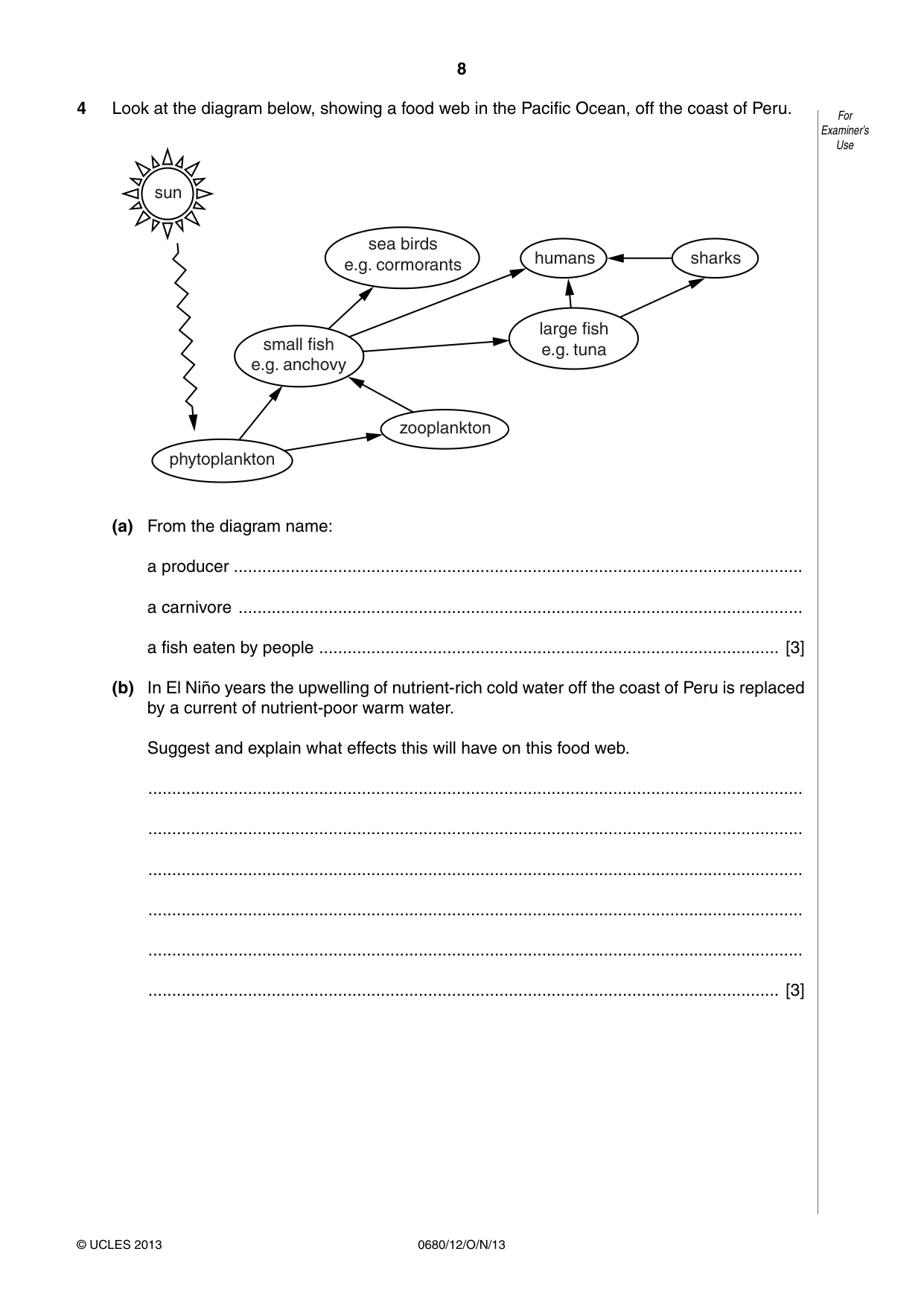
8 0680/12/O/N/13 © UCLES 2013 For Examiner’s Use 4 Look at the diagram below, showing a food web in the Pacific Ocean, off the coast of Peru. sea birds e.g. cormorants large fish e.g. tuna humans sharks phytoplankton zooplankton small fish e.g. anchovy sun (a) From the diagram name: a producer … a carnivore … a fish eaten by people … [3] (b) In El Niño years the upwelling of nutrient-rich cold water off the coast of Peru is replaced by a current of nutrient-poor warm water. Suggest and explain what effects this will have on this food web. … … … … … … [3]
Question paper, page 9
9 0680/12/O/N/13 © UCLES 2013 [Turn over For Examiner’s Use (c) In the 1970s, the anchovy fish were seriously over-fished, resulting in a collapse of the population of anchovy. Explain the different effects that this will have had on the populations of zooplankton and sea birds e.g. cormorants. zooplankton … … … … sea birds … … … … [4] [Total: 10]
Question paper, page 10
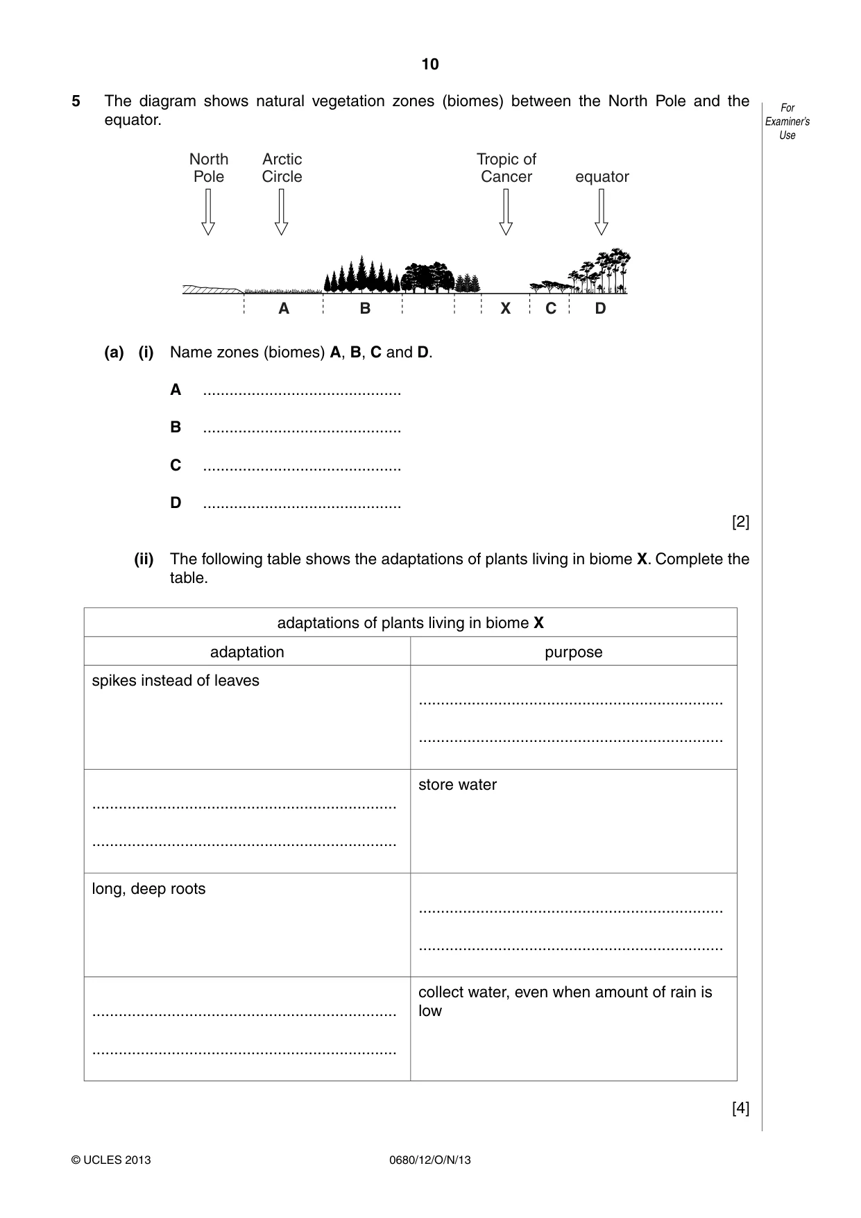
10 0680/12/O/N/13 © UCLES 2013 For Examiner’s Use 5 The diagram shows natural vegetation zones (biomes) between the North Pole and the equator. A B North Pole Arctic Circle Tropic of Cancer equator C X D (a) (i) Name zones (biomes) A, B, C and D. A … B … C … D … [2] (ii) The following table shows the adaptations of plants living in biome X. Complete the table. adaptations of plants living in biome X adaptation purpose spikes instead of leaves … … … … store water long, deep roots … … … … collect water, even when amount of rain is low [4]
Question paper, page 11
11 0680/12/O/N/13 © UCLES 2013 [Turn over For Examiner’s Use (b) Biome X can be extended into areas of biome C in a process called desertification. Describe the human and physical factors which explain this. … … … … … … … …[4] [Total: 10]
Question paper, page 12
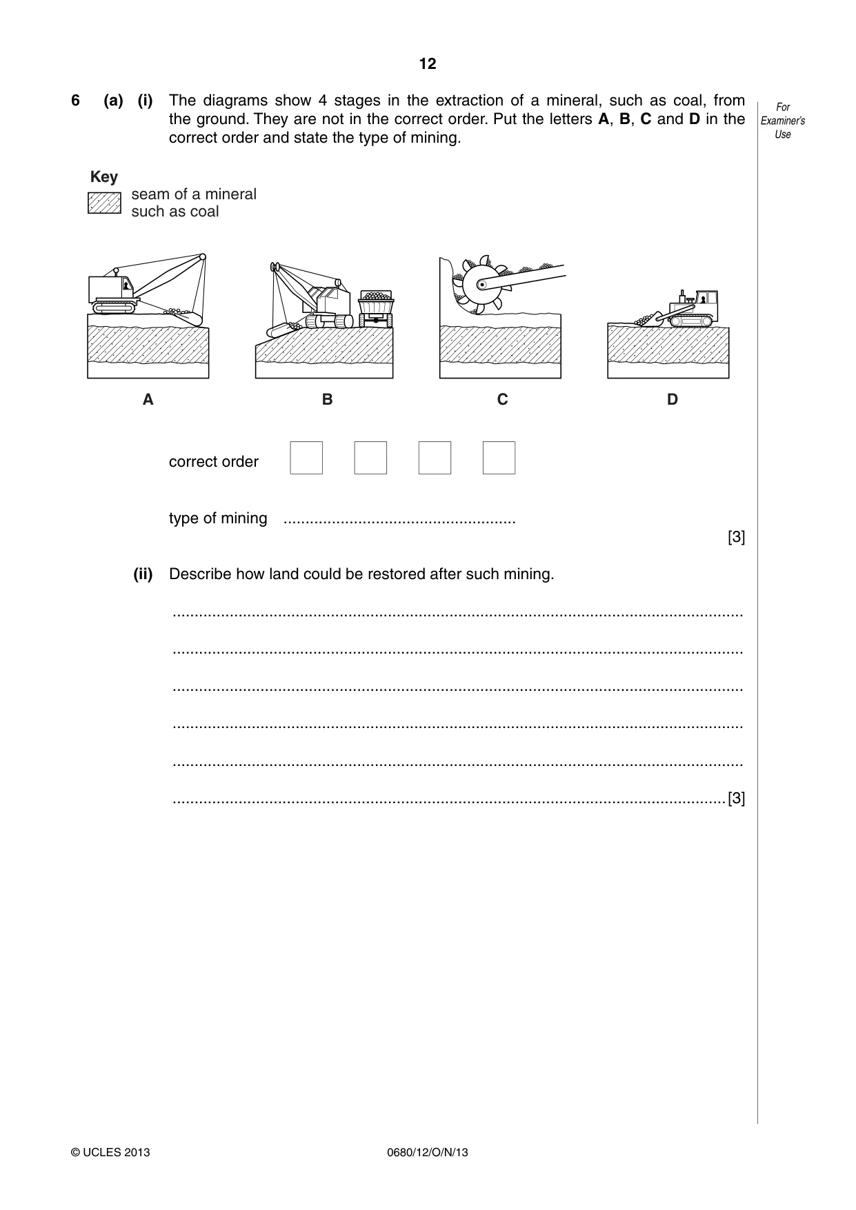
12 0680/12/O/N/13 © UCLES 2013 For Examiner’s Use 6 (a) (i) The diagrams show 4 stages in the extraction of a mineral, such as coal, from the ground. They are not in the correct order. Put the letters A, B, C and D in the correct order and state the type of mining. A B C D Key seam of a mineral such as coal correct order type of mining … [3] (ii) Describe how land could be restored after such mining. … … … … … …[3]
Question paper, page 13
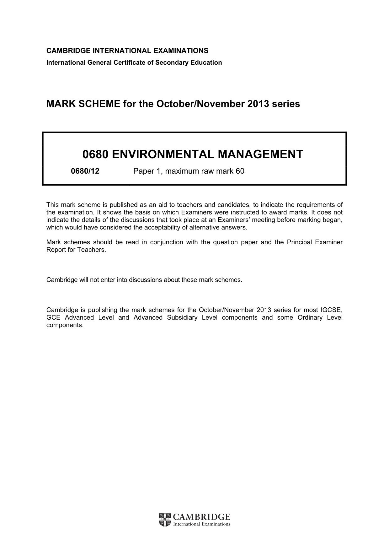
13 0680/12/O/N/13 © UCLES 2013 For Examiner’s Use (b) The graph below shows past and expected coal production for China. 2500 2000 1500 mass of coal produced / megatonnes 1000 500 1950 2000 2050 year 2100 0 (i) Give the date of the expected peak production from this graph. … [1] (ii) What could be done to extend the life of the known coal reserves in China? … … … … … …[3] [Total: 10]
Question paper, page 14
14 0680/12/O/N/13 © UCLES 2013 BLANK PAGE
Question paper, page 15
15 0680/12/O/N/13 © UCLES 2013 BLANK PAGE
Question paper, page 16
16 0680/12/O/N/13 © UCLES 2013 BLANK PAGE Permission to reproduce items where third-party owned material protected by copyright is included has been sought and cleared where possible. Every reasonable effort has been made by the publisher (UCLES) to trace copyright holders, but if any items requiring clearance have unwittingly been included, the publisher will be pleased to make amends at the earliest possible opportunity. University of Cambridge International Examinations is part of the Cambridge Assessment Group. Cambridge Assessment is the brand name of University of Cambridge Local Examinations Syndicate (UCLES), which is itself a department of the University of Cambridge.
Mark scheme, page 1
CAMBRIDGE INTERNATIONAL EXAMINATIONS International General Certificate of Secondary Education MARK SCHEME for the October/November 2013 series 0680 ENVIRONMENTAL MANAGEMENT 0680/12 Paper 1, maximum raw mark 60 This mark scheme is published as an aid to teachers and candidates, to indicate the requirements of the examination. It shows the basis on which Examiners were instructed to award marks. It does not indicate the details of the discussions that took place at an Examiners’ meeting before marking began, which would have considered the acceptability of alternative answers. Mark schemes should be read in conjunction with the question paper and the Principal Examiner Report for Teachers. Cambridge will not enter into discussions about these mark schemes. Cambridge is publishing the mark schemes for the October/November 2013 series for most IGCSE, GCE Advanced Level and Advanced Subsidiary Level components and some Ordinary Level components.
Mark scheme, page 2
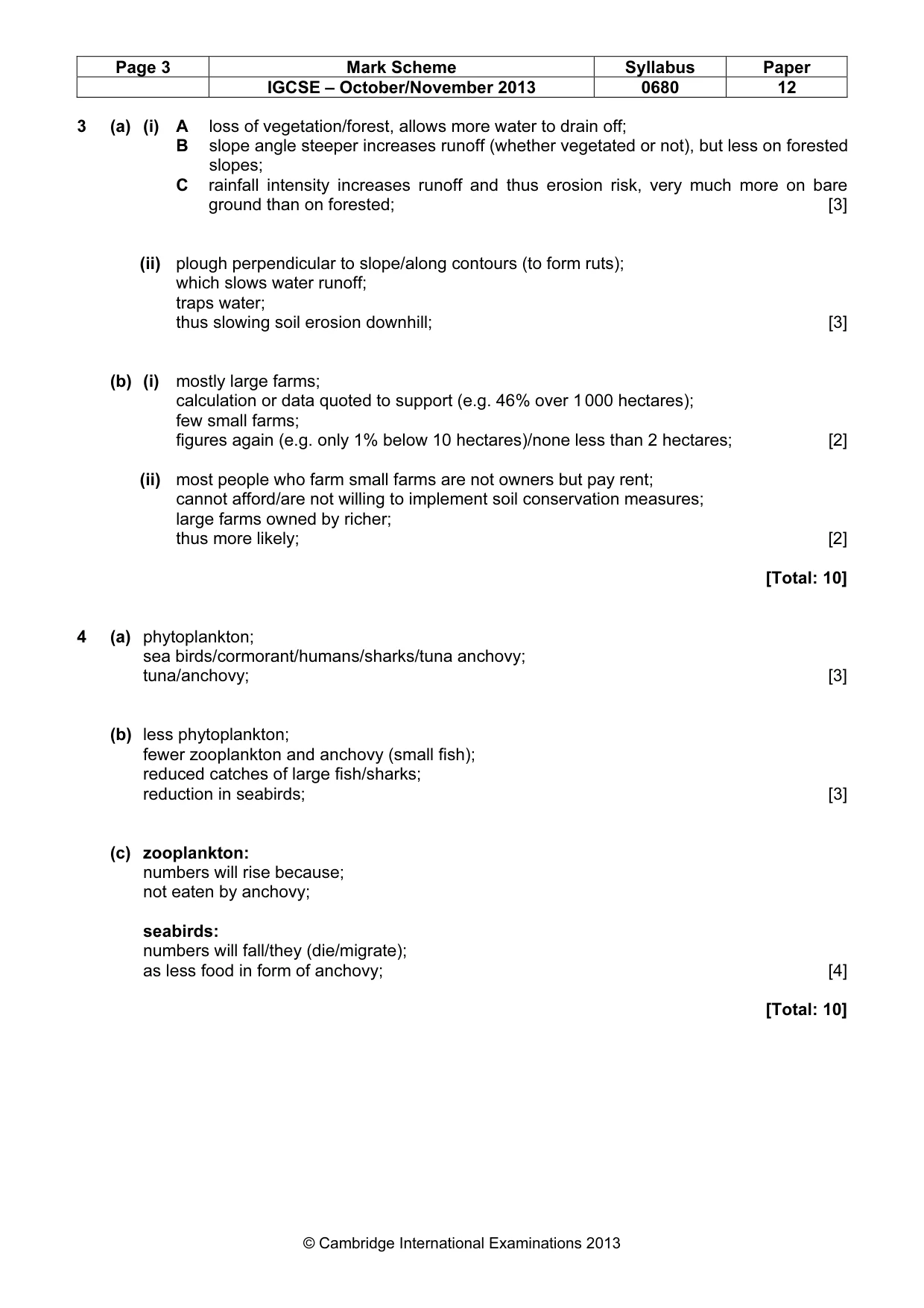
Page 2 Mark Scheme Syllabus Paper IGCSE – October/November 2013 0680 12 © Cambridge International Examinations 2013 1 (a) (i) lowest shale band; [1] (ii) sedimentary [1] (iii) any of the limestones: building/fertiliser or detail/cement/aggregate roads/desulfurisation/glass/blast furnace or description of used/AVP; sandstone: building/statues/coasters; shale: bitumen/oil bearing; [1] (iv) (any) limestone; heating; and (high) pressure; [2] (b) (i) (from) dead plants/eq; pressure/time; [2] (ii) less coal is used in 2005; oil was less than coal, now more; gas is more, but still less than coal; renewables much more, but much less than coal; (credit one for any calculation to illustrate a point) [2] (iii) rise of renewables; coal stocks depleted/owtte; worries about pollution/ named problem (e.g. greenhouse effect); [1] [Total: 10] 2 (a) (i) millet correctly plotted AND key; y–axis labelled yield AND kg per hectare (IGNORE x label); [2] (ii) wheat; 1507 (kg hectare)/ %; [1] (b) fertiliser; improved varieties/(A) GM;; irrigation; use of pesticides/herbicides; machinery but only if qualified; [3] (c) soil ruined; by fertilisers; pesticides dangerous; loss of fish/frogs; because of chemicals; high cost of purchasing e.g. fertiliser/pesticides (once). [4] [Total: 10]
Mark scheme, page 3
Page 3 Mark Scheme Syllabus Paper IGCSE – October/November 2013 0680 12 © Cambridge International Examinations 2013 3 (a) (i) A loss of vegetation/forest, allows more water to drain off; B slope angle steeper increases runoff (whether vegetated or not), but less on forested slopes; C rainfall intensity increases runoff and thus erosion risk, very much more on bare ground than on forested; [3] (ii) plough perpendicular to slope/along contours (to form ruts); which slows water runoff; traps water; thus slowing soil erosion downhill; [3] (b) (i) mostly large farms; calculation or data quoted to support (e.g. 46% over 1 000 hectares); few small farms; figures again (e.g. only 1% below 10 hectares)/none less than 2 hectares; [2] (ii) most people who farm small farms are not owners but pay rent; cannot afford/are not willing to implement soil conservation measures; large farms owned by richer; thus more likely; [2] [Total: 10] 4 (a) phytoplankton; sea birds/cormorant/humans/sharks/tuna anchovy; tuna/anchovy; [3] (b) less phytoplankton; fewer zooplankton and anchovy (small fish); reduced catches of large fish/sharks; reduction in seabirds; [3] (c) zooplankton: numbers will rise because; not eaten by anchovy; seabirds: numbers will fall/they (die/migrate); as less food in form of anchovy; [4] [Total: 10]
Mark scheme, page 4
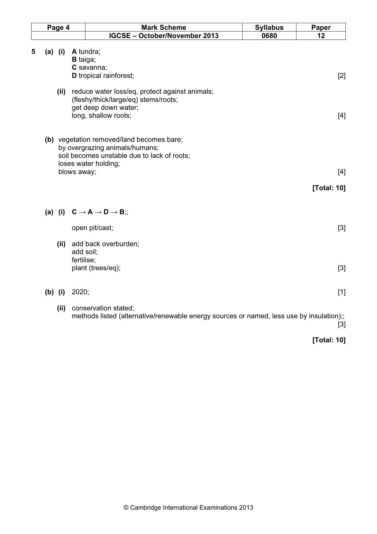
Page 4 Mark Scheme Syllabus Paper IGCSE – October/November 2013 0680 12 © Cambridge International Examinations 2013 5 (a) (i) A tundra; B taiga; C savanna; D tropical rainforest; [2] (ii) reduce water loss/eq, protect against animals; (fleshy/thick/large/eq) stems/roots; get deep down water; long, shallow roots; [4] (b) vegetation removed/land becomes bare; by overgrazing animals/humans; soil becomes unstable due to lack of roots; loses water holding; blows away; [4] [Total: 10] (a) (i) C → A → D → B;; open pit/cast; [3] (ii) add back overburden; add soil; fertilise; plant (trees/eq); [3] (b) (i) 2020; [1] (ii) conservation stated; methods listed (alternative/renewable energy sources or named, less use by insulation);; [3] [Total: 10]
What you needed in this session
Cambridge’s own grade thresholds for 2013 Oct/Nov, Paper 1 · Variant 2. A higher threshold means an easier paper — the bar moves with how the cohort did.