Cambridge IGCSE Environmental Management 0680 — 2006 May/June Paper 4 · Variant 1
0680/41/M/J/06 · 60 marks · ≈68 min
The question paper and its mark scheme, free to read here and free to download. This is Cambridge’s own paper, exactly as it was sat.
Question paper20 pages


Mark scheme3 pages
Answers below. Sit the paper first if you are practising.
Paper as text
Question paper, page 1
This document consists of 18 printed pages and 2 blank pages. SP (NF/CGW) T07224/3 © UCLES 2006 [Turn over UNIVERSITY OF CAMBRIDGE INTERNATIONAL EXAMINATIONS International General Certificate of Secondary Education General Certificate of Education Ordinary Level ENVIRONMENTAL MANAGEMENT 0680/04 5014/02 Alternative to Coursework May/June 2006 1 hour 30 minutes Candidates answer on the Question Paper. Additional Materials: Ruler READ THESE INSTRUCTIONS FIRST Write your Centre number, candidate number and name on all the work you hand in. Write in dark blue or black pen. You may use a soft pencil for any diagrams, graphs or rough working. Do not use staples, paper clips, highlighters, glue or correction fluid. Answer all questions. Study the appropriate Source materials before you start to write your answers. Credit will be given for appropriate selection and use of data in your answers and for relevant interpretation of these data. Suggestions for data sources are given in some questions. You may use the source data to draw diagrams and graphs or to do calculations to illustrate your answers. At the end of the examination, fasten all your work securely together. The number of marks is given in brackets [ ] at the end of each question or part question. Centre Number Candidate Number Name For Examiner’s Use www.XtremePapers.com
Question paper, page 2
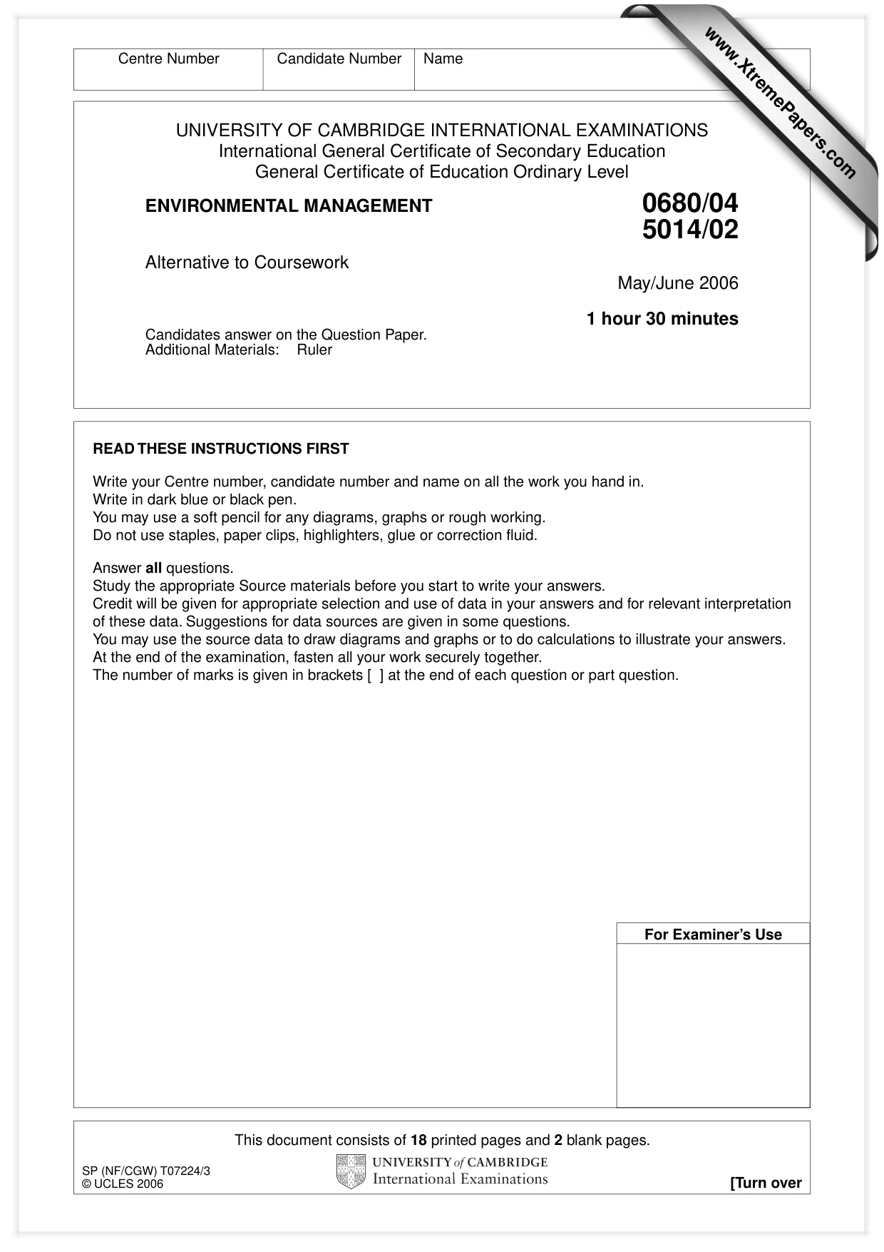
2 0680/04, 5014/02/M/J/06 © UCLES 2006 Bonaire Fig. 1 Caribbean Sea
Question paper, page 3
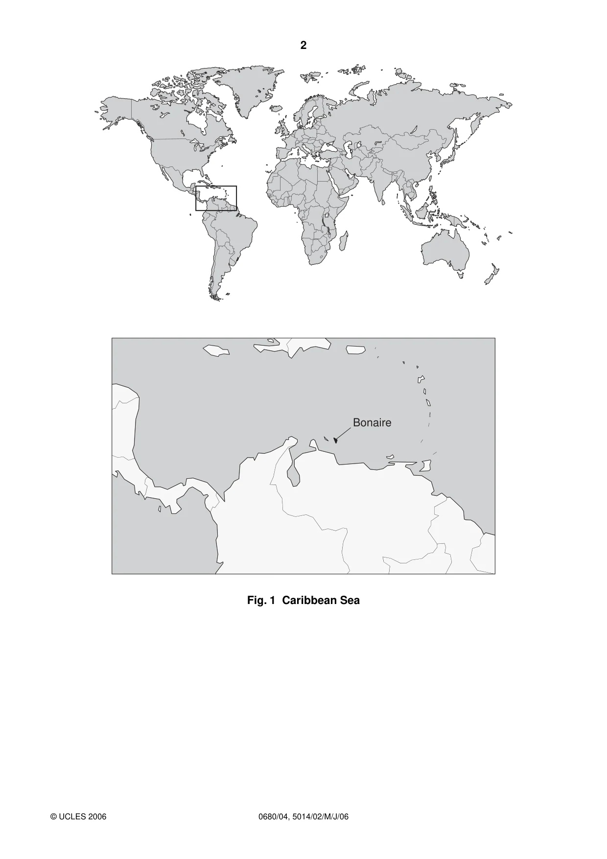
3 0680/04, 5014/02/M/J/06 © UCLES 2006 [Turn over N Caribbean sea 12° N 30 km main town Key: saltpans 0 Fig. 2 map of Bonaire Bonaire is a tropical island, 39 km long and from 5–12 km wide. Its only natural resource is salt and only 10% of the land area is suitable for growing crops because it is too dry. The economy of the island mainly relies on petroleum transhipment, production of industrial grade salt and tourism.
Question paper, page 4
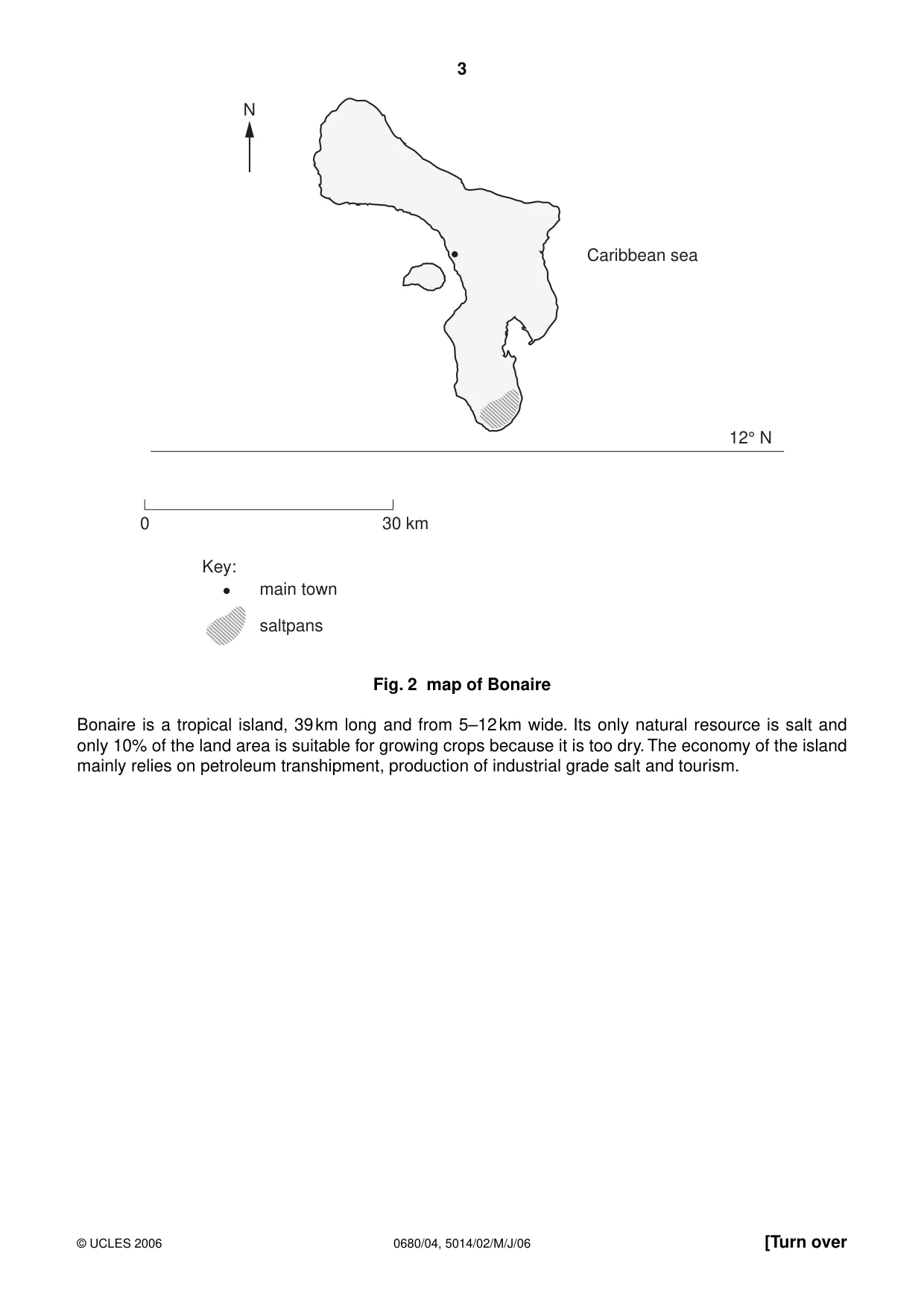
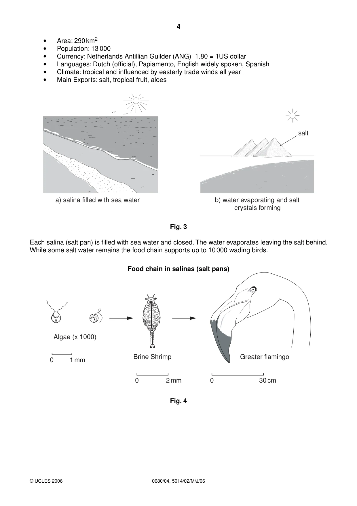
4 0680/04, 5014/02/M/J/06 © UCLES 2006 • Area: 290 km2 • Population: 13 000 • Currency: Netherlands Antillian Guilder (ANG) 1.80 = 1US dollar • Languages: Dutch (official), Papiamento, English widely spoken, Spanish • Climate: tropical and influenced by easterly trade winds all year • Main Exports: salt, tropical fruit, aloes salt b) water evaporating and salt crystals forming a) salina filled with sea water Fig. 3 Each salina (salt pan) is filled with sea water and closed. The water evaporates leaving the salt behind. While some salt water remains the food chain supports up to 10 000 wading birds. Food chain in salinas (salt pans) Algae (x 1000) Brine Shrimp Greater flamingo 0 30 cm 0 2 mm 0 1 mm Fig. 4
Question paper, page 5
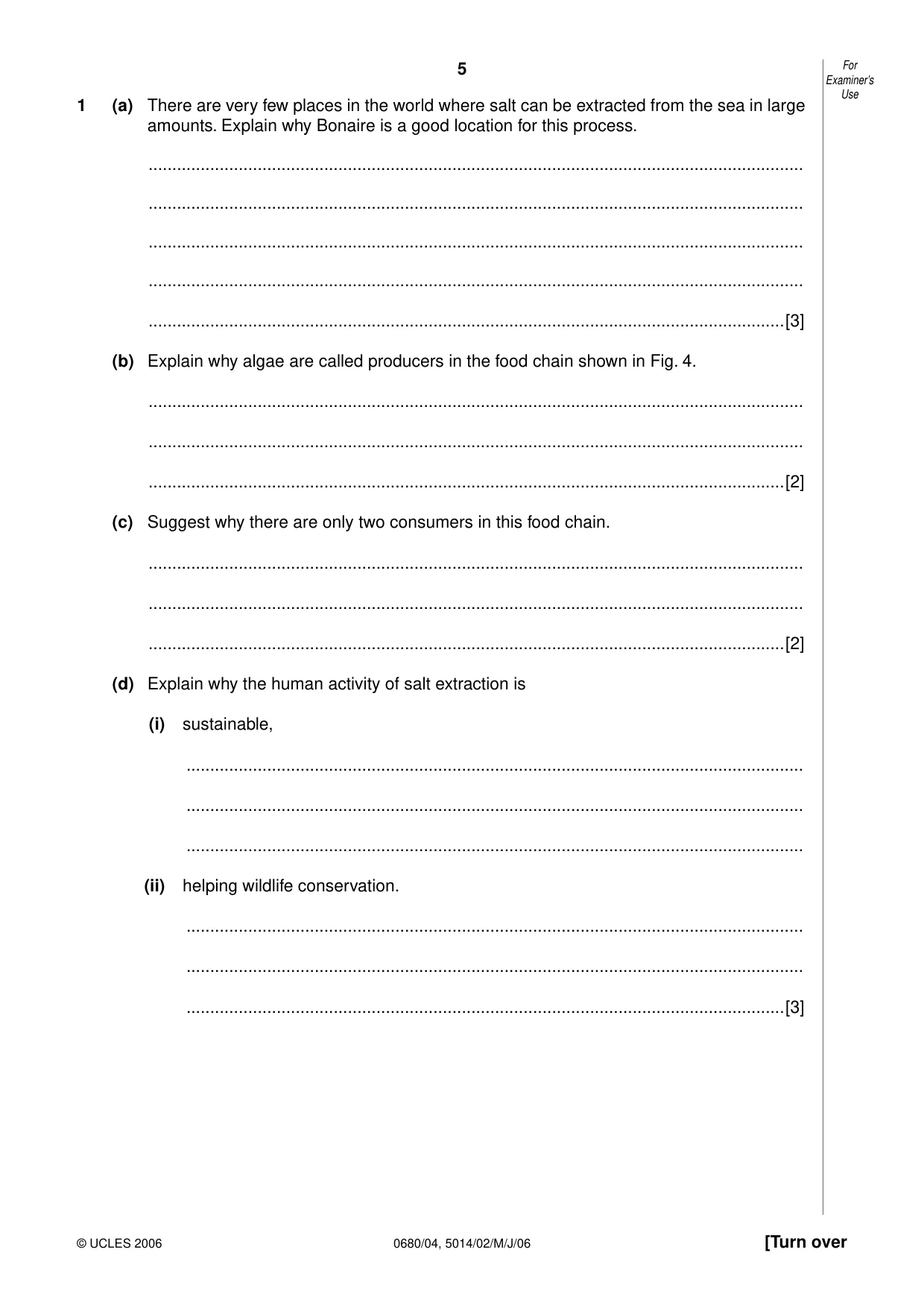
5 0680/04, 5014/02/M/J/06 [Turn over For Examiner’s Use © UCLES 2006 1 (a) There are very few places in the world where salt can be extracted from the sea in large amounts. Explain why Bonaire is a good location for this process. … … … … …[3] (b) Explain why algae are called producers in the food chain shown in Fig. 4. … … …[2] (c) Suggest why there are only two consumers in this food chain. … … …[2] (d) Explain why the human activity of salt extraction is (i) sustainable, … … … (ii) helping wildlife conservation. … … …[3]
Question paper, page 6
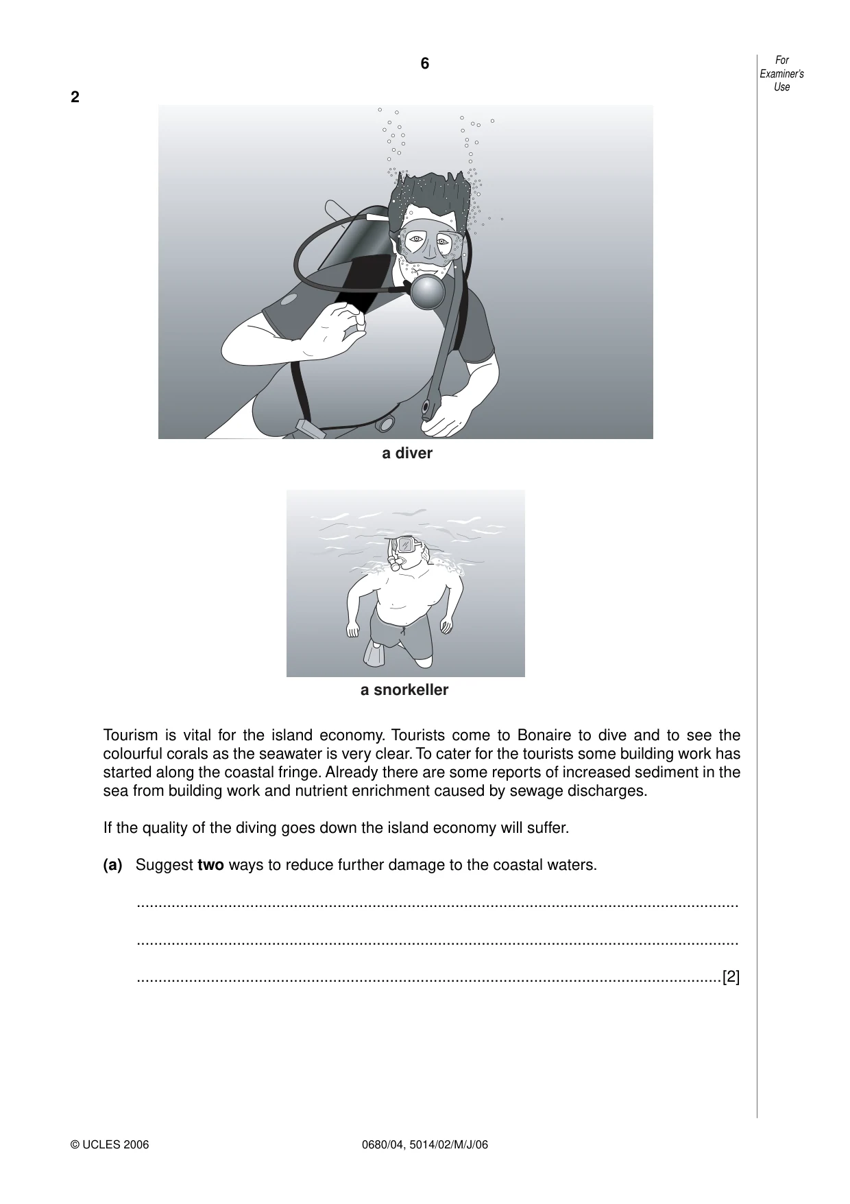
6 0680/04, 5014/02/M/J/06 For Examiner’s Use © UCLES 2006 2 a diver a snorkeller Tourism is vital for the island economy. Tourists come to Bonaire to dive and to see the colourful corals as the seawater is very clear. To cater for the tourists some building work has started along the coastal fringe. Already there are some reports of increased sediment in the sea from building work and nutrient enrichment caused by sewage discharges. If the quality of the diving goes down the island economy will suffer. (a) Suggest two ways to reduce further damage to the coastal waters. … … …[2]
Question paper, page 7
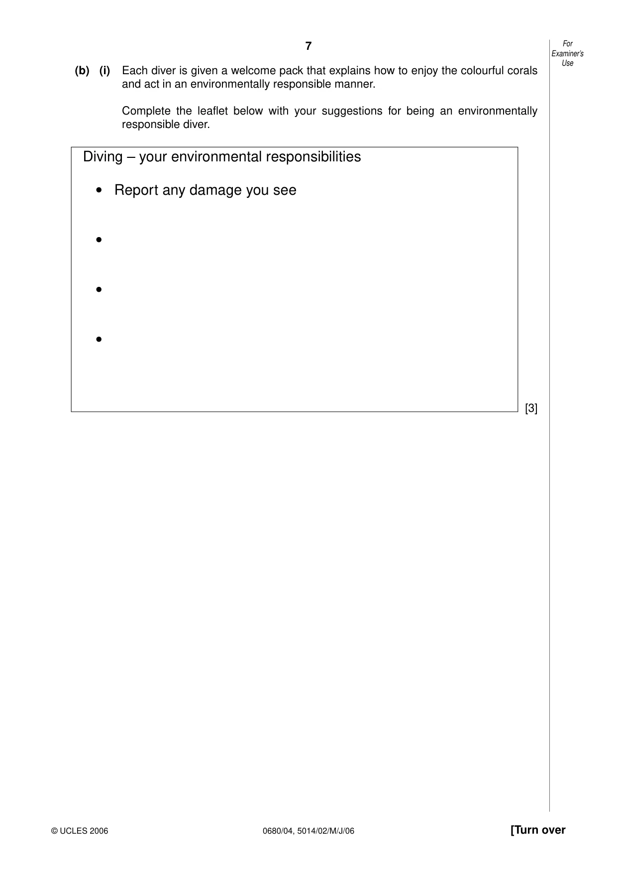
7 0680/04, 5014/02/M/J/06 [Turn over For Examiner’s Use © UCLES 2006 (b) (i) Each diver is given a welcome pack that explains how to enjoy the colourful corals and act in an environmentally responsible manner. Complete the leaflet below with your suggestions for being an environmentally responsible diver. Diving – your environmental responsibilities • Report any damage you see • • • [3]
Question paper, page 8
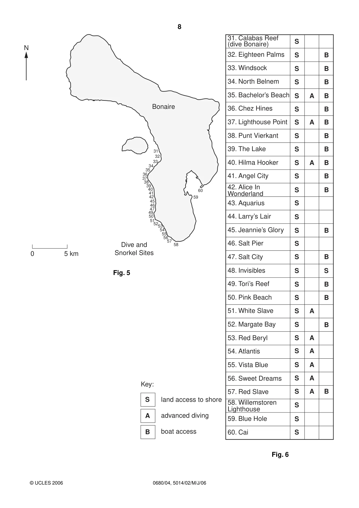
8 0680/04, 5014/02/M/J/06 © UCLES 2006 N 31 32 33 34 35 36 37 38 39 40 41 42 45 46 47 49 50 515253 54 55 56 57 58 59 60 Dive and Snorkel Sites Bonaire 5 km 0 32. Eighteen Palms S S S S S S S S S S S S S S S S S S S S S S S S S S S S S S A A A A A A A A A B B B B B B B B B B B B B S B B B B 33. Windsock 34. North Belnem 35. Bachelor’s Beach 36. Chez Hines 37. Lighthouse Point 38. Punt Vierkant 39. The Lake 40. Hilma Hooker 41. Angel City 42. Alice In Wonderland 43. Aquarius 44. Larry’s Lair 45. Jeannie’s Glory 46. Salt Pier 47. Salt City 48. Invisibles 49. Tori’s Reef 50. Pink Beach 51. White Slave 52. Margate Bay 53. Red Beryl 54. Atlantis 55. Vista Blue 56. Sweet Dreams 57. Red Slave 58. Willemstoren Lighthouse 59. Blue Hole 60. Cai 31. Calabas Reef (dive Bonaire) Fig. 5 Key: land access to shore advanced diving boat access S A B Fig. 6
Question paper, page 9
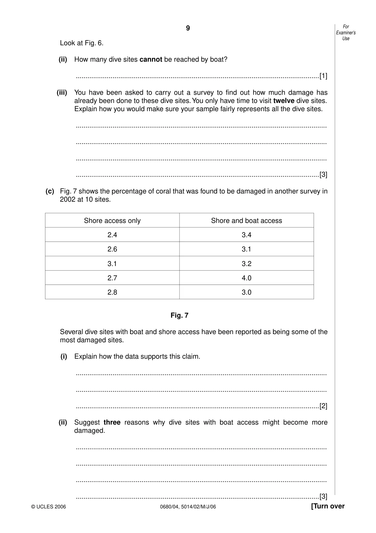
9 0680/04, 5014/02/M/J/06 [Turn over For Examiner’s Use © UCLES 2006 Look at Fig. 6. (ii) How many dive sites cannot be reached by boat? …[1] (iii) You have been asked to carry out a survey to find out how much damage has already been done to these dive sites. You only have time to visit twelve dive sites. Explain how you would make sure your sample fairly represents all the dive sites. … … … …[3] (c) Fig. 7 shows the percentage of coral that was found to be damaged in another survey in 2002 at 10 sites. Shore access only Shore and boat access 2.4 3.4 2.6 3.1 3.1 3.2 2.7 4.0 2.8 3.0 Fig. 7 Several dive sites with boat and shore access have been reported as being some of the most damaged sites. (i) Explain how the data supports this claim. … … …[2] (ii) Suggest three reasons why dive sites with boat access might become more damaged. … … … …[3]
Question paper, page 10
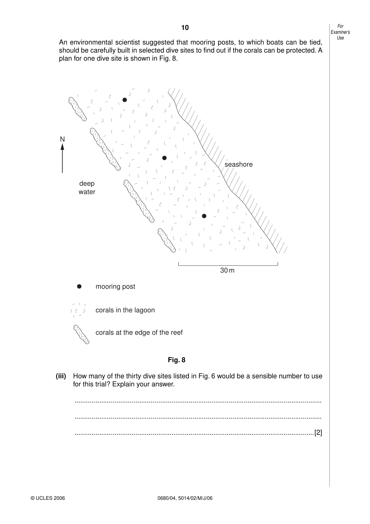
10 0680/04, 5014/02/M/J/06 For Examiner’s Use © UCLES 2006 An environmental scientist suggested that mooring posts, to which boats can be tied, should be carefully built in selected dive sites to find out if the corals can be protected. A plan for one dive site is shown in Fig. 8. seashore 30 m mooring post corals in the lagoon corals at the edge of the reef deep water N Fig. 8 (iii) How many of the thirty dive sites listed in Fig. 6 would be a sensible number to use for this trial? Explain your answer. … … …[2]
Question paper, page 11
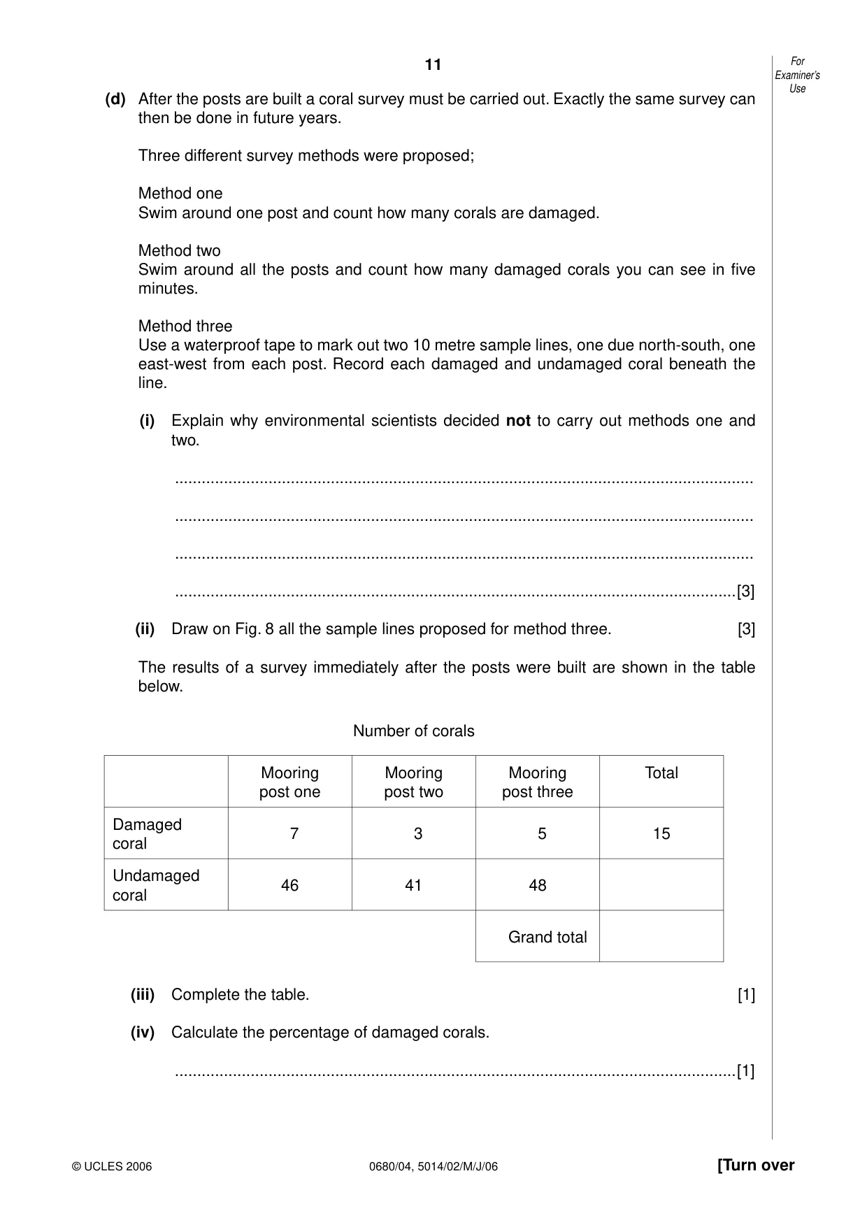
11 0680/04, 5014/02/M/J/06 [Turn over For Examiner’s Use © UCLES 2006 (d) After the posts are built a coral survey must be carried out. Exactly the same survey can then be done in future years. Three different survey methods were proposed; Method one Swim around one post and count how many corals are damaged. Method two Swim around all the posts and count how many damaged corals you can see in five minutes. Method three Use a waterproof tape to mark out two 10 metre sample lines, one due north-south, one east-west from each post. Record each damaged and undamaged coral beneath the line. (i) Explain why environmental scientists decided not to carry out methods one and two. … … … …[3] (ii) Draw on Fig. 8 all the sample lines proposed for method three. [3] The results of a survey immediately after the posts were built are shown in the table below. Number of corals Mooring post one Mooring post two Mooring post three Total Damaged coral 7 3 5 15 Undamaged coral 46 41 48 Grand total (iii) Complete the table. [1] (iv) Calculate the percentage of damaged corals. …[1]
Question paper, page 12
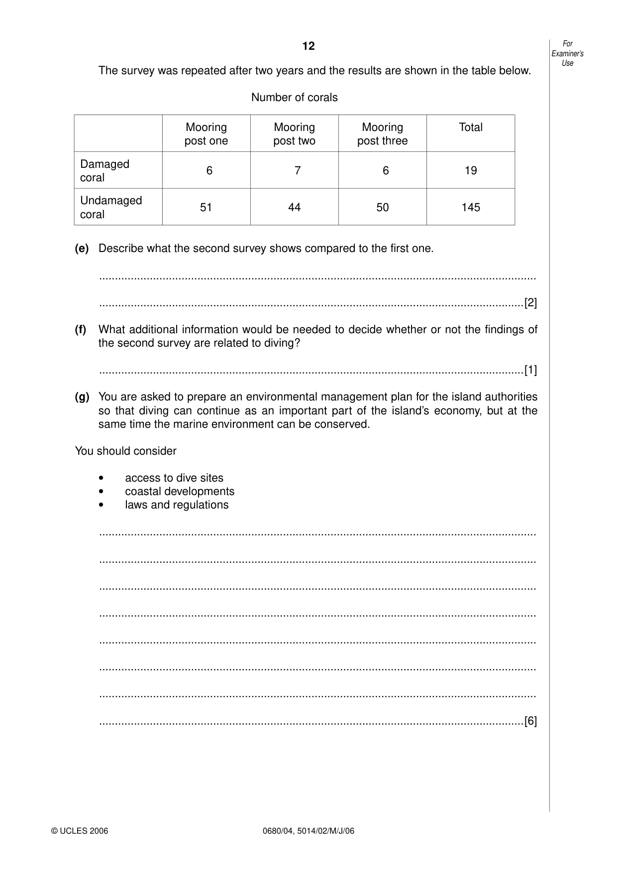
12 0680/04, 5014/02/M/J/06 For Examiner’s Use © UCLES 2006 The survey was repeated after two years and the results are shown in the table below. Number of corals Mooring post one Mooring post two Mooring post three Total Damaged coral 6 7 6 19 Undamaged coral 51 44 50 145 (e) Describe what the second survey shows compared to the first one. … …[2] (f) What additional information would be needed to decide whether or not the findings of the second survey are related to diving? …[1] (g) You are asked to prepare an environmental management plan for the island authorities so that diving can continue as an important part of the island’s economy, but at the same time the marine environment can be conserved. You should consider • access to dive sites • coastal developments • laws and regulations … … … … … … … …[6]
Question paper, page 13
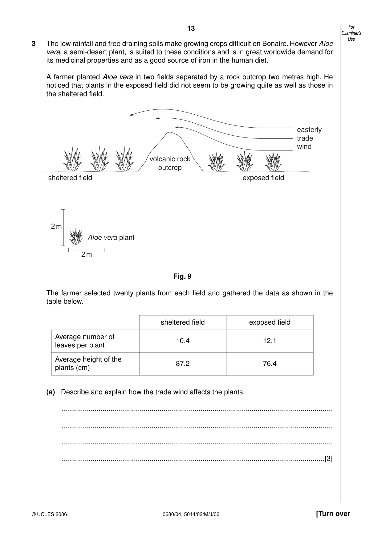
13 0680/04, 5014/02/M/J/06 [Turn over For Examiner’s Use © UCLES 2006 3 The low rainfall and free draining soils make growing crops difficult on Bonaire. However Aloe vera, a semi-desert plant, is suited to these conditions and is in great worldwide demand for its medicinal properties and as a good source of iron in the human diet. A farmer planted Aloe vera in two fields separated by a rock outcrop two metres high. He noticed that plants in the exposed field did not seem to be growing quite as well as those in the sheltered field. volcanic rock outcrop sheltered field Aloe vera plant 2 m 2 m exposed field easterly trade wind Fig. 9 The farmer selected twenty plants from each field and gathered the data as shown in the table below. sheltered field exposed field Average number of leaves per plant 10.4 12.1 Average height of the plants (cm) 87.2 76.4 (a) Describe and explain how the trade wind affects the plants. … … … …[3]
Question paper, page 14
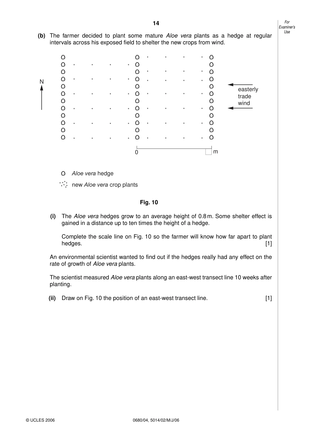
14 0680/04, 5014/02/M/J/06 For Examiner’s Use © UCLES 2006 (b) The farmer decided to plant some mature Aloe vera plants as a hedge at regular intervals across his exposed field to shelter the new crops from wind. N easterly trade wind 0 m Aloe vera hedge new Aloe vera crop plants Fig. 10 (i) The Aloe vera hedges grow to an average height of 0.8 m. Some shelter effect is gained in a distance up to ten times the height of a hedge. Complete the scale line on Fig. 10 so the farmer will know how far apart to plant hedges. [1] An environmental scientist wanted to find out if the hedges really had any effect on the rate of growth of Aloe vera plants. The scientist measured Aloe vera plants along an east-west transect line 10 weeks after planting. (ii) Draw on Fig. 10 the position of an east-west transect line. [1]
Question paper, page 15
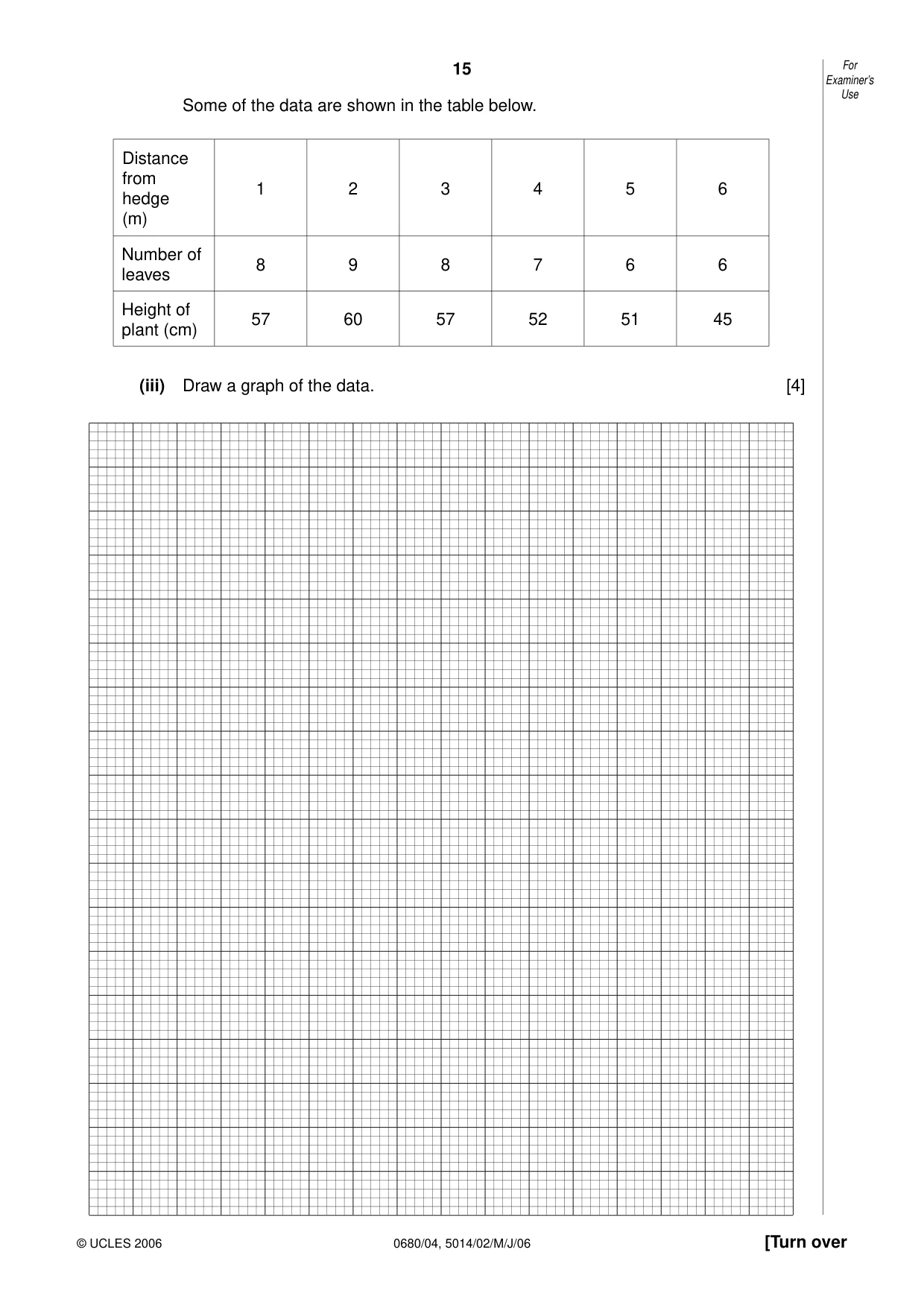
15 0680/04, 5014/02/M/J/06 [Turn over For Examiner’s Use © UCLES 2006 Some of the data are shown in the table below. Distance from hedge (m) 1 2 3 4 5 6 Number of leaves 8 9 8 7 6 6 Height of plant (cm) 57 60 57 52 51 45 (iii) Draw a graph of the data. [4]
Question paper, page 16
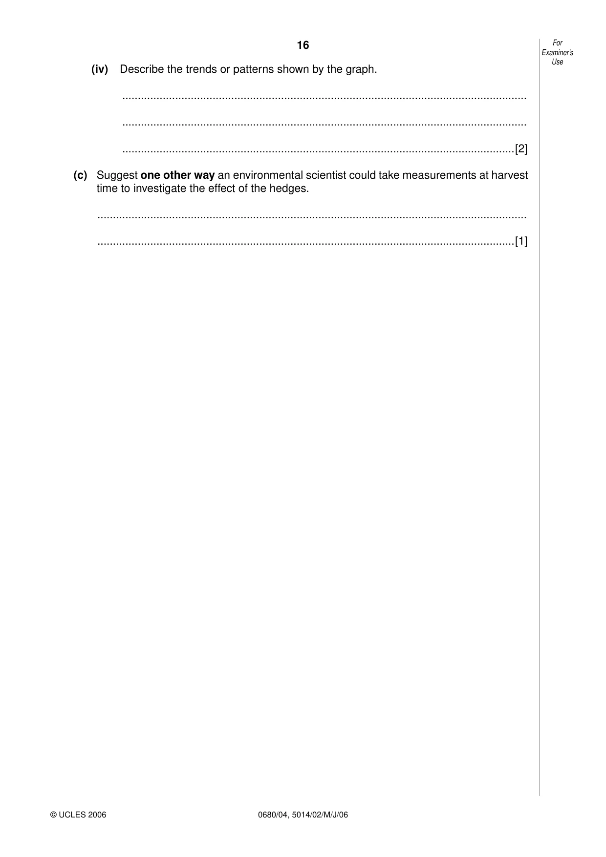
16 0680/04, 5014/02/M/J/06 For Examiner’s Use © UCLES 2006 (iv) Describe the trends or patterns shown by the graph. … … …[2] (c) Suggest one other way an environmental scientist could take measurements at harvest time to investigate the effect of the hedges. … …[1]
Question paper, page 17
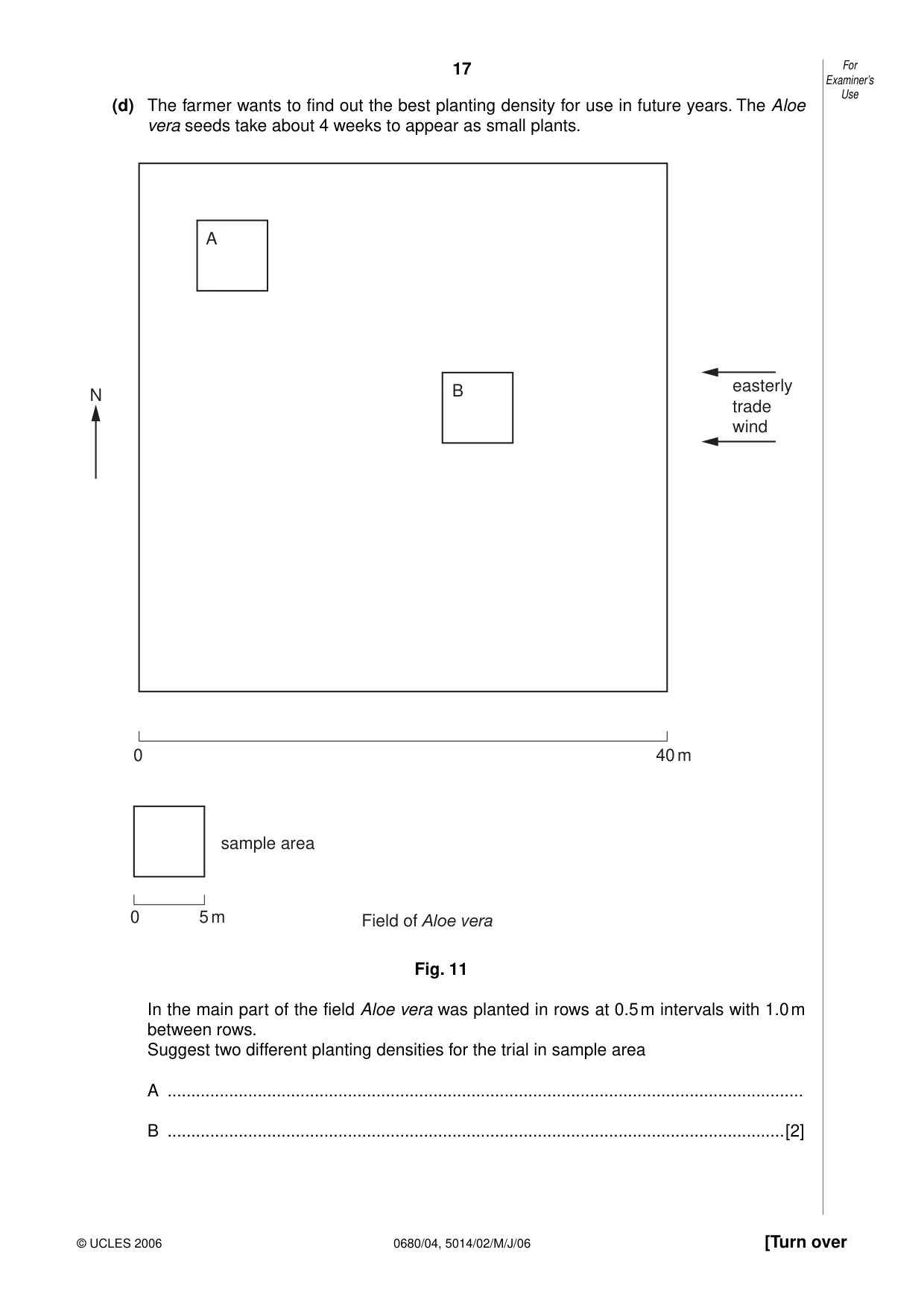
17 0680/04, 5014/02/M/J/06 [Turn over For Examiner’s Use © UCLES 2006 (d) The farmer wants to find out the best planting density for use in future years. The Aloe vera seeds take about 4 weeks to appear as small plants. N 0 0 40 m 5 m sample area A Field of Aloe vera B easterly trade wind Fig. 11 In the main part of the field Aloe vera was planted in rows at 0.5 m intervals with 1.0 m between rows. Suggest two different planting densities for the trial in sample area A … B …[2]
Question paper, page 18
18 0680/04, 5014/02/M/J/06 For Examiner’s Use © UCLES 2006 (e) Suggest some long term problems that might occur with high density planting. … … … … … …[3]
Question paper, page 20
20 0680/04, 5014/02/M/J/06 Permission to reproduce items where third-party owned material protected by copyright is included has been sought and cleared where possible. Every reasonable effort has been made by the publisher (UCLES) to trace copyright holders, but if any items requiring clearance have unwittingly been included, the publisher will be pleased to make amends at the earliest possible opportunity. University of Cambridge International Examinations is part of the University of Cambridge Local Examinations Syndicate (UCLES), which is itself a department of the University of Cambridge. BLANK PAGE
Mark scheme, page 1
UNIVERSITY OF CAMBRIDGE INTERNATIONAL EXAMINATIONS International General Certificate of Secondary Education MARK SCHEME for the May/June 2006 question paper 0680 ENVIRONMENTAL MANAGEMENT 0680/04 Paper 4, maximum raw mark 60 These mark schemes are published as an aid to teachers and students, to indicate the requirements of the examination. They show the basis on which Examiners were initially instructed to award marks. They do not indicate the details of the discussions that took place at an Examiners’ meeting before marking began. Any substantial changes to the mark scheme that arose from these discussions will be recorded in the published Report on the Examination. All Examiners are instructed that alternative correct answers and unexpected approaches in candidates’ scripts must be given marks that fairly reflect the relevant knowledge and skills demonstrated. Mark schemes must be read in conjunction with the question papers and the Report on the Examination. The minimum marks in these components needed for various grades were previously published with these mark schemes, but are now instead included in the Report on the Examination for this session. • CIE will not enter into discussion or correspondence in connection with these mark schemes. CIE is publishing the mark schemes for the May/June 2006 question papers for most IGCSE and GCE Advanced Level and Advanced Subsidiary Level syllabuses and some Ordinary Level syllabuses. www.XtremePapers.com
Mark scheme, page 2
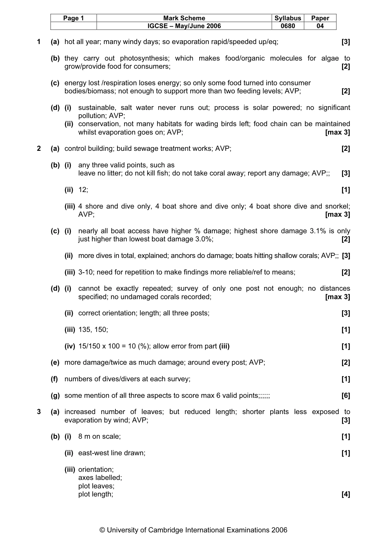
Page 1 Mark Scheme Syllabus Paper IGCSE – May/June 2006 0680 04 © University of Cambridge International Examinations 2006 1 (a) hot all year; many windy days; so evaporation rapid/speeded up/eq; [3] (b) they carry out photosynthesis; which makes food/organic molecules for algae to grow/provide food for consumers; [2] (c) energy lost /respiration loses energy; so only some food turned into consumer bodies/biomass; not enough to support more than two feeding levels; AVP; [2] (d) (i) sustainable, salt water never runs out; process is solar powered; no significant pollution; AVP; (ii) conservation, not many habitats for wading birds left; food chain can be maintained whilst evaporation goes on; AVP; [max 3] 2 (a) control building; build sewage treatment works; AVP; [2] (b) (i) any three valid points, such as leave no litter; do not kill fish; do not take coral away; report any damage; AVP;; [3] (ii) 12; [1] (iii) 4 shore and dive only, 4 boat shore and dive only; 4 boat shore dive and snorkel; AVP; [max 3] (c) (i) nearly all boat access have higher % damage; highest shore damage 3.1% is only just higher than lowest boat damage 3.0%; [2] (ii) more dives in total, explained; anchors do damage; boats hitting shallow corals; AVP;; [3] (iii) 3-10; need for repetition to make findings more reliable/ref to means; [2] (d) (i) cannot be exactly repeated; survey of only one post not enough; no distances specified; no undamaged corals recorded; [max 3] (ii) correct orientation; length; all three posts; [3] (iii) 135, 150; [1] (iv) 15/150 x 100 = 10 (%); allow error from part (iii) [1] (e) more damage/twice as much damage; around every post; AVP; [2] (f) numbers of dives/divers at each survey; [1] (g) some mention of all three aspects to score max 6 valid points;;;;;; [6] 3 (a) increased number of leaves; but reduced length; shorter plants less exposed to evaporation by wind; AVP; [3] (b) (i) 8 m on scale; [1] (ii) east-west line drawn; [1] (iii) orientation; axes labelled; plot leaves; plot length; [4]
Mark scheme, page 3
Page 2 Mark Scheme Syllabus Paper IGCSE – May/June 2006 0680 04 © University of Cambridge International Examinations 2006 (iv) as distance increases from hedge number of leaves drops; and length of leaves drops; [2] (c) weigh fresh harvest from known sections of field/eq; [1] (d) two sensible densities/one may be lower than suggested;;; [2] (e) soil exhaustion/minerals used up; loss of soil structure/more prone to erosion; disease in crops; loss of biodiversity in context; AVP;; [3] Total 60
What you needed in this session
Cambridge’s own grade thresholds for 2006 May/June, Paper 4 · Variant 1. A higher threshold means an easier paper — the bar moves with how the cohort did.