Questions as text
Q1 · Study the map extract for Furusjøen, Norway 0976/22 Oct/Nov 2018
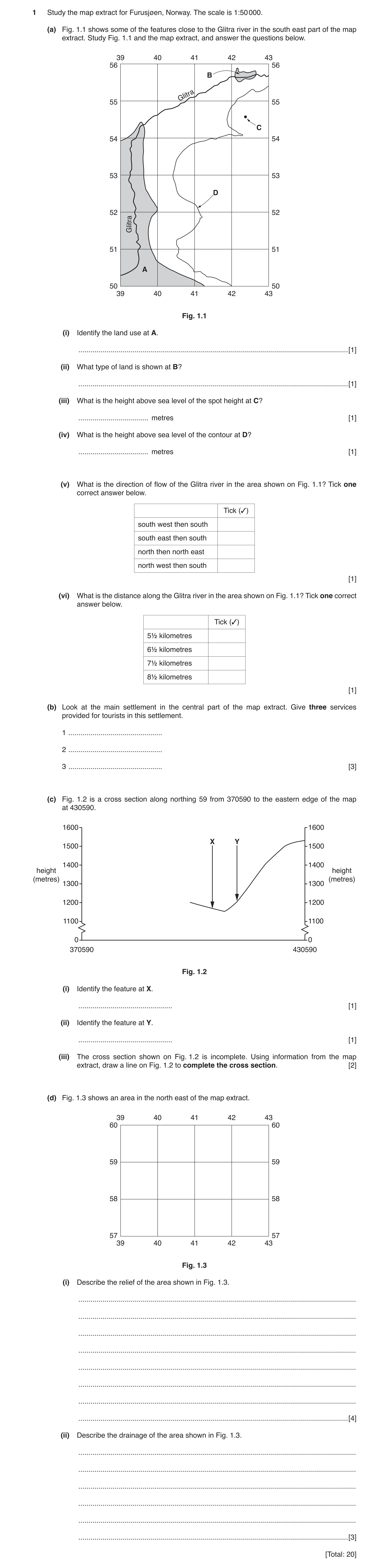
1 Study the map extract for Furusjøen, Norway. The scale is 1:50 000. (a) Fig. 1.1 shows some of the features close to the Glitra river in the south east part of the map extract. Study Fig. 1.1 and the map extract, and answer the questions below. 39 40 41 42 43 56 56 B Glitra 55 55 C 54 54 53 53 D 52 52 Glitra 51 51 A 50 50 39 40 41 42 43 Fig. 1.1 (i) Identify the land use at A. … [1] (ii) What type of land is shown at B? … [1] (iii) What is the height above sea level of the spot height at C? … metres [1] (iv) What is the height above sea level of the contour at D? … metres [1] (v) What is the direction of flow of the Glitra river in the area shown on Fig. 1.1? Tick one correct answer below. Tick (✓) south west then south south east then south north then north east north west then south [1] (vi) What is the distance along the Glitra river in the area shown on Fig. 1.1? Tick one correct answer below. Tick (✓) 5½ kilometres 6½ kilometres 7½ kilometres 8½ kilometres [1] (b) Look at the main settlement in the central part of the map extract. Give three services provided for tourists in this settlement. 1 … 2 … 3 … [3] (c) Fig. 1.2 is a cross section along northing 59 from 370590 to the eastern edge of the map at 430590. 1600 1600 X Y 1500 1500 1400 1400 height height (metres) (metres) 1300 1300 1200 1200 1100 1100 0 0 370590 430590 Fig. 1.2 (i) Identify the feature at X. … [1] (ii) Identify the feature at Y. … [1] (iii) The cross section shown on Fig. 1.2 is incomplete. Using information from the map extract, draw a line on Fig. 1.2 to complete the cross section. [2] (d) Fig. 1.3 shows an area in the north east of the map extract. 39 40 41 42 43 60 60 59 59 58 58 57 57 39 40 41 42 43 Fig. 1.3 (i) Describe the relief of the area shown in Fig. 1.3. … … … … … … … … [4] (ii) Describe the drainage of the area shown in Fig. 1.3. … … … … … … [3] [Total: 20]
20 marks
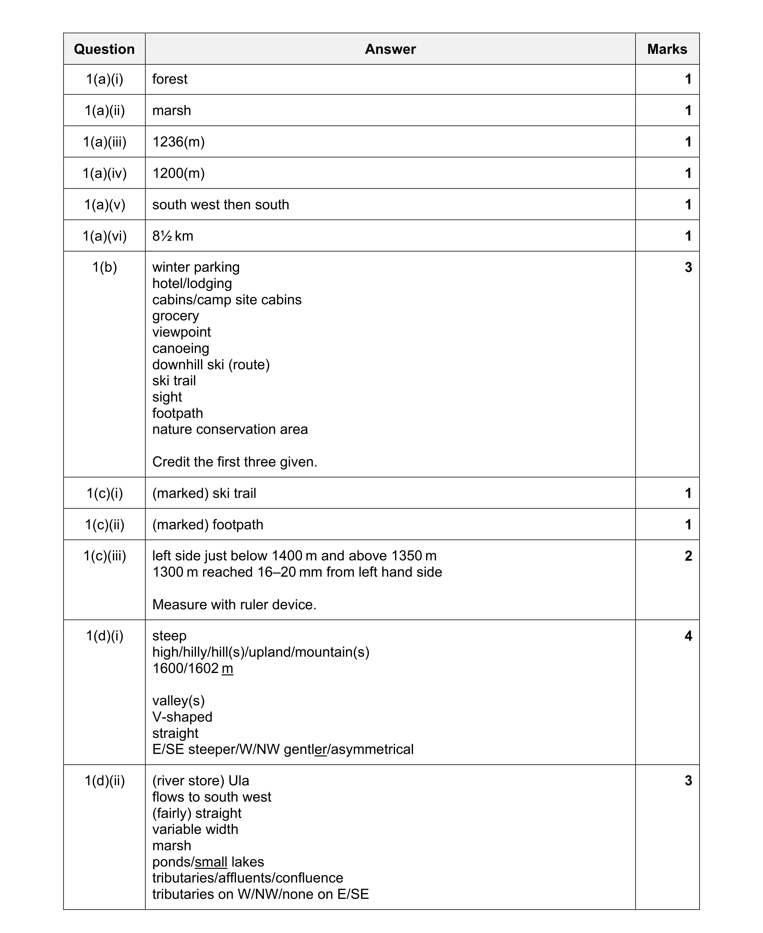
Mark scheme: Question Answer Marks 1(a)(i) forest 1 1(a)(ii) marsh 1 1(a)(iii) 1236(m) 1 1(a)(iv) 1200(m) 1 1(a)(v) south west then south 1 1(a)(vi) 8½ km 1 1(b) winter parking 3 hotel/lodging cabins/camp site cabins grocery viewpoint canoeing downhill ski (route) ski trail sight footpath nature conservation area Credit the first three given. 1(c)(i) (marked) ski trail 1 1(c)(ii) (marked) footpath 1 1(c)(iii) left side just below 1400 m and above 1350 m 2 1300 m reached 16–20 mm from left hand side Measure with ruler device. 1(d)(i) steep 4 high/hilly/hill(s)/upland/mountain(s) 1600/1602 m valley(s) V-shaped straight E/SE steeper/W/NW gentler/asymmetrical 1(d)(ii) (river store) Ula 3 flows to south west (fairly) straight variable width marsh ponds/small lakes tributaries/affluents/confluence tributaries on W/NW/none on E/SE
This question in 0976/22 Oct/Nov 2018
Q2 · Study the map extract for Degeberga, Sweden 0976/22 Oct/Nov 2019
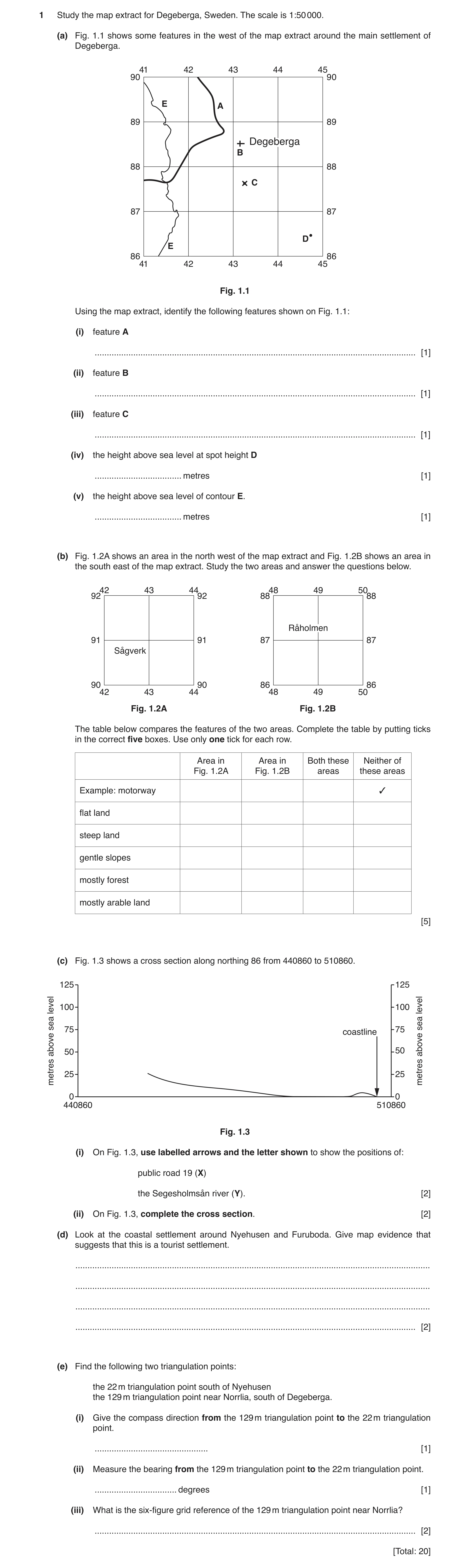
1 Study the map extract for Degeberga, Sweden. The scale is 1:50 000. (a) Fig. 1.1 shows some features in the west of the map extract around the main settlement of Degeberga. 41 42 43 44 45 90 90 E A 89 89 Degeberga B 88 88 C 87 87 D E 86 86 41 42 43 44 45 Fig. 1.1 Using the map extract, identify the following features shown on Fig. 1.1: (i) feature A … [1] (ii) feature B … [1] (iii) feature C … [1] (iv) the height above sea level at spot height D … metres [1] (v) the height above sea level of contour E. … metres [1] (b) Fig. 1.2A shows an area in the north west of the map extract and Fig. 1.2B shows an area in the south east of the map extract. Study the two areas and answer the questions below. 42 43 44 48 49 50 92 92 88 88 Råholmen 91 91 87 87 Sågverk 90 90 86 86 42 43 44 48 49 50 Fig. 1.2A Fig. 1.2B The table below compares the features of the two areas. Complete the table by putting ticks in the correct five boxes. Use only one tick for each row. Area in Area in Both these Neither of Fig. 1.2A Fig. 1.2B areas these areas ✓ Example: motorway flat land steep land gentle slopes mostly forest mostly arable land [5] (c) Fig. 1.3 shows a cross section along northing 86 from 440860 to 510860. 125 125 level 100 100 level sea sea 75 75 coastline above 50 50 above 25 25metres metres 0 0 440860 510860 Fig. 1.3 (i) On Fig. 1.3, use labelled arrows and the letter shown to show the positions of: public road 19 (X) the Segesholmsån river (Y). [2] (ii) On Fig. 1.3, complete the cross section. [2] (d) Look at the coastal settlement around Nyehusen and Furuboda. Give map evidence that suggests that this is a tourist settlement. … … … … [2] (e) Find the following two triangulation points: the 22 m triangulation point south of Nyehusen the 129 m triangulation point near Norrlia, south of Degeberga. (i) Give the compass direction from the 129 m triangulation point to the 22 m triangulation point. … [1] (ii) Measure the bearing from the 129 m triangulation point to the 22 m triangulation point. … degrees [1] (iii) What is the six-figure grid reference of the 129 m triangulation point near Norrlia? … [2] [Total: 20]
20 marks
Mark scheme: Question Answer Marks 1(a)(i) public road, (ignore width) 1 1(a)(ii) church 1 1(a)(iii) mast 1 1(a)(iv) 33 (m) 1 1(a)(v) 100 (m) 1 1(b) 5 flat land 9 steep land 9 gentle slopes 9 mostly forest 9 mostly arable 9 land 1(c)(i) public road 28–32 mm from left hand margin, 2 river 97–101 mm from left hand margin 1(c)(ii) land continuously rising to the left hand margin, 2 highest point over 100 m but not more than 112 m 1(d) bathing, 2 leisure/second homes, camp site/camping, roads give access to sea, dunes, cycle path(s) 1(e)(i) ENE/NE 1 1(e)(ii) 63–67° 1 1(e)(iii) 438 855 = 2 2 43_85_ = (correct square) 1
This question in 0976/22 Oct/Nov 2019
Q3 · Study the map extract for Hamoir, Belgium 0976/22 May/June 2020
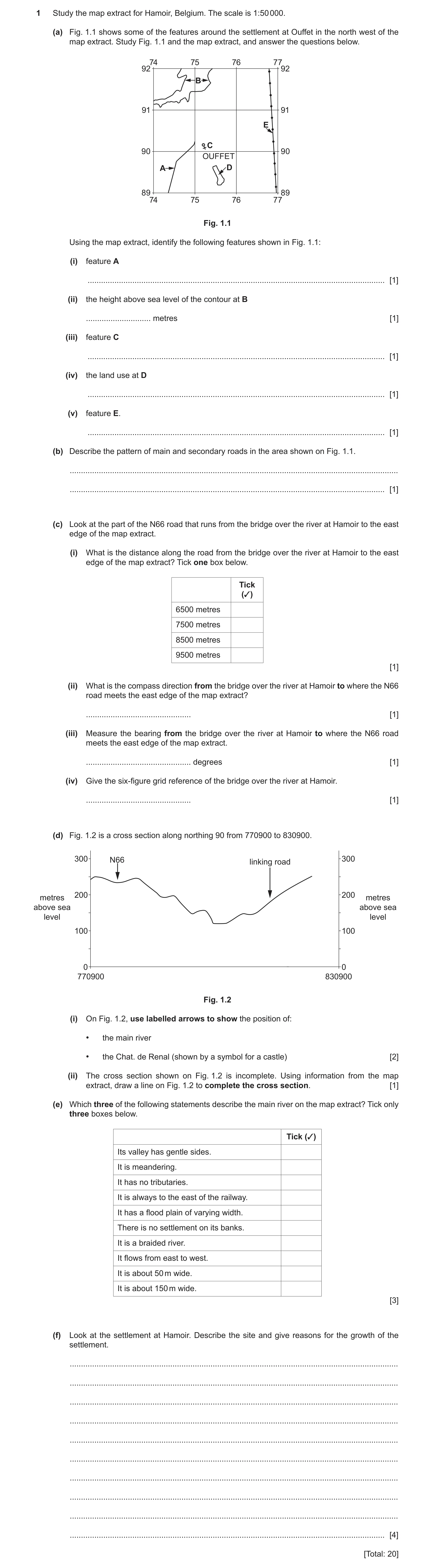
1 Study the map extract for Hamoir, Belgium. The scale is 1:50 000. (a) Fig. 1.1 shows some of the features around the settlement at Ouffet in the north west of the map extract. Study Fig. 1.1 and the map extract, and answer the questions below. 74 75 76 77 92 92 B 91 91 E C 90 90 OUFFET A D 89 89 74 75 76 77 Fig. 1.1 Using the map extract, identify the following features shown in Fig. 1.1: (i) feature A … [1] (ii) the height above sea level of the contour at B … metres [1] (iii) feature C … [1] (iv) the land use at D … [1] (v) feature E. … [1] (b) Describe the pattern of main and secondary roads in the area shown on Fig. 1.1. … … [1] (c) Look at the part of the N66 road that runs from the bridge over the river at Hamoir to the east edge of the map extract. (i) What is the distance along the road from the bridge over the river at Hamoir to the east edge of the map extract? Tick one box below. Tick (✓) 6500 metres 7500 metres 8500 metres 9500 metres [1] (ii) What is the compass direction from the bridge over the river at Hamoir to where the N66 road meets the east edge of the map extract? … [1] (iii) Measure the bearing from the bridge over the river at Hamoir to where the N66 road meets the east edge of the map extract. … degrees [1] (iv) Give the six-figure grid reference of the bridge over the river at Hamoir. … [1] (d) Fig. 1.2 is a cross section along northing 90 from 770900 to 830900. 300 N66 linking road 300 200 200 metres metres above sea above sea level level 100 100 0 0 770900 830900 Fig. 1.2 (i) On Fig. 1.2, use labelled arrows to show the position of: • the main river • the Chat. de Renal (shown by a symbol for a castle) [2] (ii) The cross section shown on Fig. 1.2 is incomplete. Using information from the map extract, draw a line on Fig. 1.2 to complete the cross section. [1] (e) Which three of the following statements describe the main river on the map extract? Tick only three boxes below. Tick (✓) Its valley has gentle sides. It is meandering. It has no tributaries. It is always to the east of the railway. It has a flood plain of varying width. There is no settlement on its banks. It is a braided river. It flows from east to west. It is about 50 m wide. It is about 150 m wide. [3] (f) Look at the settlement at Hamoir. Describe the site and give reasons for the growth of the settlement. … … … … … … … … … … [4] [Total: 20]
20 marks
Mark scheme: Question Answer Marks 1(a)(i) (secondary) road, 1 1(a)(ii) 250 metres, 1 1(a)(iii) church, 1 1(a)(iv) deciduous trees, 1 1(a)(v) high voltage line, 1 1(b) radial/meet in centre/meet in Ouffet, 1 main road E–W and secondary road SSW–NNE, 1(c)(i) 8500 m, 1 1(c)(ii) east-south east, 1 1(c)(iii) 109–113, 1 1(c)(iv) 801890, 1 1(d)(i) correct position of river, 2 correct position of Chat. De Renal, 1(d)(ii) section continuing to rise but not reaching 300m, 1 1(e) it is meandering, 3 it has a flood plain of varying width, it is 50–100 m wide, 1(f) on valley floor, ) 4 on valley side, ) in valley alone = 1 west side/east facing, road junction, bridge point, railway, services/2 named services, river for water, woodland for fuel,
This question in 0976/22 May/June 2020
Question 4 0976/22 May/June 2020
4 Figs. 4.1 and 4.2 (Insert) show two valleys in northern England. Describe the relief features of each valley. Valley in Fig. 4.1 … … … … … … … … … … … Valley in Fig. 4.2 … … … … … … … … … … [8] [Total: 8]
8 marks
Mark scheme: 4 Fig. 4.1 8 flat floor/flood plain second mark for flat area between lakes, steep sides concave slope, straight valley, wide valley/floor, delta, U-shaped, Fig. 4.2 V-shaped (look at V in valley), steep sides, narrow valley/floor, interlocking spurs, straight slopes, Reserve 3 marks for each photograph.
This question in 0976/22 May/June 2020
Q5 · Study the map extract for Biancavilla, Italy 0976/22 Oct/Nov 2020
1 Study the map extract for Biancavilla, Italy. The scale is 1:50 000. (a) Fig. 1.1 shows some of the features around the settlement at S. Maria di Licodia in the south east of the map extract. Study Fig. 1.1 and the map extract, and answer the questions below. 87 88 89 90 91 92 93 64 64 S. Maria di Licodia B C 63 63 E D A 62 62 87 88 89 90 91 92 93 Fig. 1.1 Using the map extract, identify the following features shown in Fig. 1.1: (i) the name of river A … [1] (ii) the height above sea level of the spot height at B … metres [1] (iii) feature C … [1] (iv) feature D … [1] (v) feature E. … [1] (b) Fig. 1.2 shows two areas, P in the south west of the map extract and Q, in the north east of the map extract. Study the two areas and answer the questions below. Area P Area Q 82 84 92 94 64 64 70 70 S. B O N AC I A M R B A R A 62 62 68 68 82 84 92 94 Fig. 1.2 The table below compares the features of the two areas. Complete the table by putting ticks in the correct four boxes. Use only one tick (3) for each row. Both these Neither of Feature Area P Area Q areas these areas a railway dispersed settlement dense settlement land over 900 m above sea level [4] (c) Fig. 1.3 is a cross section through the settlement of Biancavilla, from 840630 in the south west to 890670 in the north east. 600 600 Y 500 500 X 400 400 height height 300 300 (metres) (metres) 200 200 100 100 0 0 840630 890670 south west north east Fig. 1.3 (i) Identify feature X. … [1] (ii) Identify feature Y. … [1] (iii) In Fig. 1.3, use a labelled arrow to show the position of the settlement of Biancavilla. [1] (d) Find the junction of national main road 121 with another national main road in the west of the map extract. (i) What is the distance along the road, from this junction, to the south edge of the map extract? … metres [1] (ii) What is the compass direction from the road junction, to where the road meets the south edge of the map? … [1] (iii) Measure the compass bearing from the road junction, to where the road meets the south edge of the map. … degrees [1] (iv) What is the six-figure grid reference of the road junction? Tick (3) one box below. Tick (3) 822674 676876 824677 674823 827683 [1] (e) Describe the natural features of the Fiume Simeto river in the west of the map extract. … … … … … … … … [4] [Total: 20]
20 marks
Mark scheme: Question Answer Marks 1(a)(i) (V. ne di) Licodia, 1 1(a)(ii) 317 (metres), 1 1(a)(iii) church, 1 1(a)(iv) cemetery, 1 1(a)(v) (national main) road, 1 1(b) 4 Area P Area Q Both these Neither of areas these areas a railway dispersed settlement dense settlement land over 900 m 1(c)(i) river/Fiume Simeto, 1 1(c)(ii) (national main) road, 1 1(c)(iii) position of Biancavilla shown with an arrow between 13 mm and 30 mm from the right hand margin. Allow with an unlabelled arrow. 1 1(d)(i) 7500 – 7850 metres, 1 1(d)(ii) south east, 1 1(d)(iii) 137 – 142°, 1 1(d)(iv) 822674, 1 1(e) flows south/south south-east, (south east = 0, but allow east then south) 4 meandering/bends/curves, etc., tributary(ies)/confluence(s), variable width/lake, islands/braiding/eyots/splits and rejoins, width 50 – 100 m, gentle gradient,
This question in 0976/22 Oct/Nov 2020
Q6 · The drainage basin of the Nile River and its tributaries 0976/22 Oct/Nov 2020
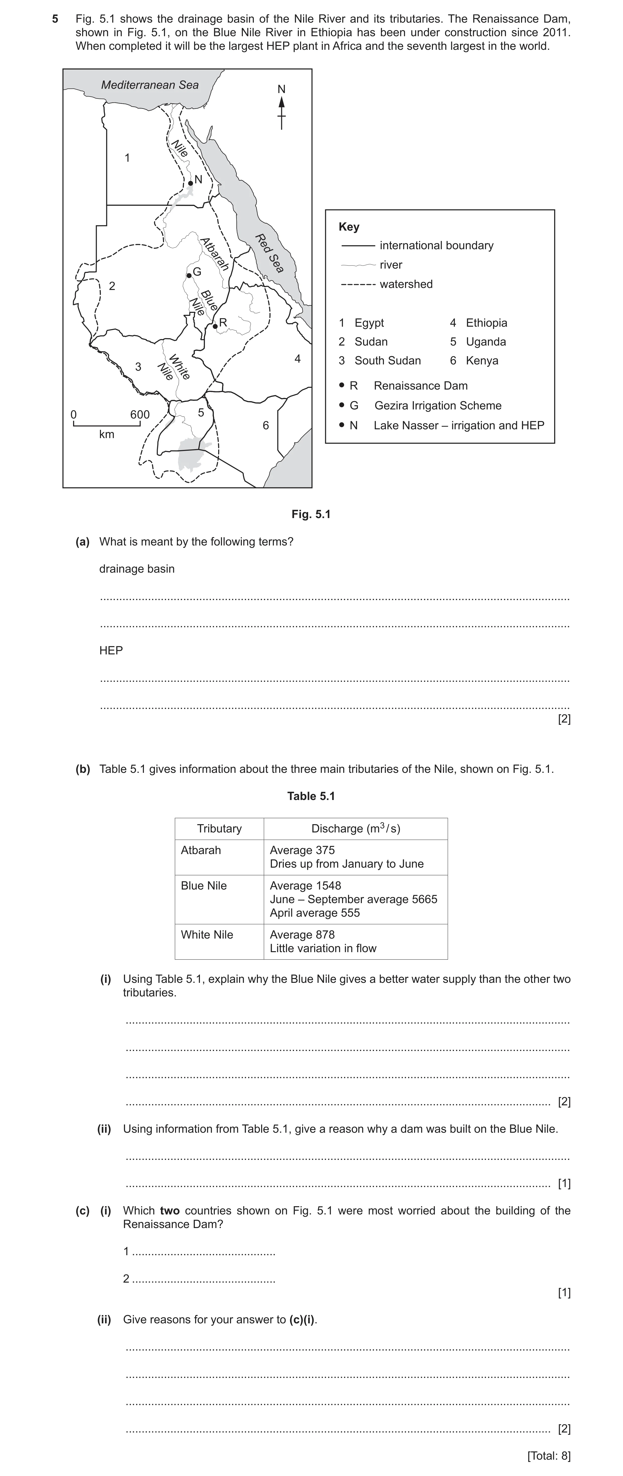
5 Fig. 5.1 shows the drainage basin of the Nile River and its tributaries. The Renaissance Dam, shown in Fig. 5.1, on the Blue Nile River in Ethiopia has been under construction since 2011. When completed it will be the largest HEP plant in Africa and the seventh largest in the world. Mediterranean Sea N Nile 1 N Key river Atbarah RedSea international boundary G 2 watershed Blue Nile R 1 Egypt 4 Ethiopia 2 Sudan 5 Uganda 4 3 South Sudan 6 Kenya 3 NileWhite R Renaissance Dam G Gezira Irrigation Scheme 0 600 5 6 N Lake Nasser – irrigation and HEP km Fig. 5.1 (a) What is meant by the following terms? drainage basin … … HEP … … [2] (b) Table 5.1 gives information about the three main tributaries of the Nile, shown on Fig. 5.1. Table 5.1 Tributary Discharge (m3 / s) Atbarah Average 375 Dries up from January to June Blue Nile Average 1548 June – September average 5665 April average 555 White Nile Average 878 Little variation in flow (i) Using Table 5.1, explain why the Blue Nile gives a better water supply than the other two tributaries. … … … … [2] (ii) Using information from Table 5.1, give a reason why a dam was built on the Blue Nile. … … [1] (c) (i) Which two countries shown on Fig. 5.1 were most worried about the building of the Renaissance Dam? 1 … 2 … [1] (ii) Give reasons for your answer to (c)(i). … … … … [2] [Total: 8]
8 marks
Mark scheme: 5(a) catchment area/area drained by a river, 2 hydroelectric (power)/hydroelectricity/description of HEP production, 5(b)(i) high(er)(est) (average) discharge/flow, (allow for part of year) 2 Atbarah dries up/Blue Nile doesn’t dry up, 5(b)(ii) large flow variation, 1 collect water from June to September high flows, 5(c)(i) Egypt and Sudan, 1 5(c)(ii) they are downstream of the dam, 2 may reduce their water flow/supply, HEP schemes affected, irrigation/agriculture affected, navigation affected, tourism affected,
This question in 0976/22 Oct/Nov 2020
Q7 · Study the map extract for Pluneret, France 0976/22 Oct/Nov 2021
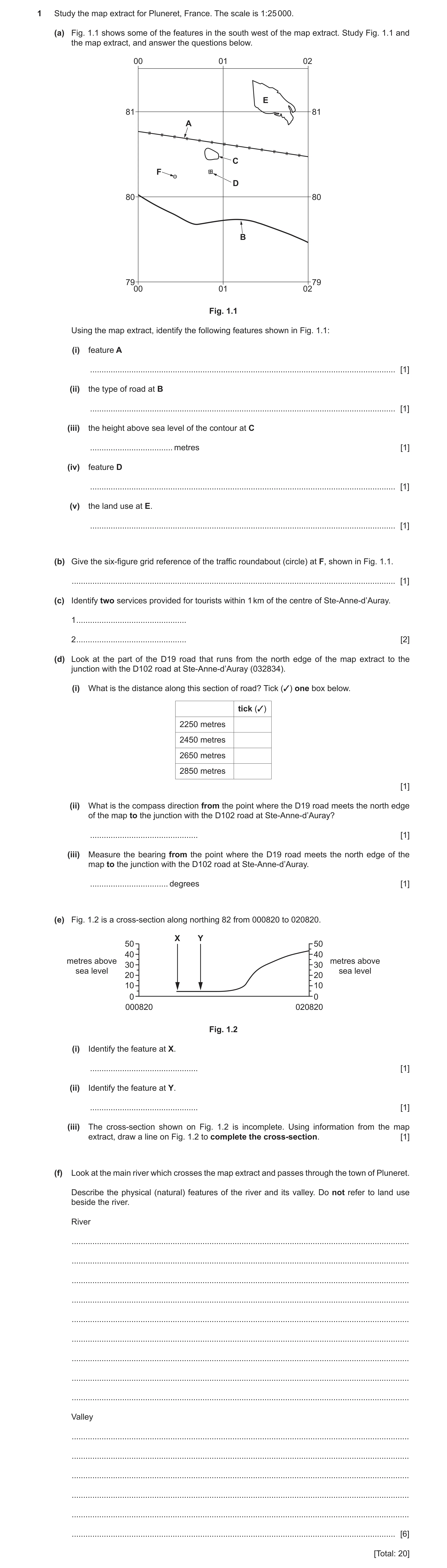
1 Study the map extract for Pluneret, France. The scale is 1:25 000. (a) Fig. 1.1 shows some of the features in the south west of the map extract. Study Fig. 1.1 and the map extract, and answer the questions below. 00 01 02 EE 81 81 AA CC FF DD 80 80 BB 7900 01 0279 Fig. 1.1 Using the map extract, identify the following features shown in Fig. 1.1: (i) feature A … [1] (ii) the type of road at B … [1] (iii) the height above sea level of the contour at C … metres [1] (iv) feature D … [1] (v) the land use at E. … [1] (b) Give the six-figure grid reference of the traffic roundabout (circle) at F, shown in Fig. 1.1. … [1] (c) Identify two services provided for tourists within 1 km of the centre of Ste-Anne-d’Auray. 1 … 2 … [2] (d) Look at the part of the D19 road that runs from the north edge of the map extract to the junction with the D102 road at Ste-Anne-d’Auray (032834). (i) What is the distance along this section of road? Tick (3) one box below. tick (3) 2250 metres 2450 metres 2650 metres 2850 metres [1] (ii) What is the compass direction from the point where the D19 road meets the north edge of the map to the junction with the D102 road at Ste-Anne-d’Auray? … [1] (iii) Measure the bearing from the point where the D19 road meets the north edge of the map to the junction with the D102 road at Ste-Anne-d’Auray. … degrees [1] (e) Fig. 1.2 is a cross-section along northing 82 from 000820 to 020820. X Y 50 50 40 40 metres above metres above 30 30 sea level sea level 20 20 10 10 0 0 000820 020820 Fig. 1.2 (i) Identify the feature at X. … [1] (ii) Identify the feature at Y. … [1] (iii) The cross-section shown on Fig. 1.2 is incomplete. Using information from the map extract, draw a line on Fig. 1.2 to complete the cross-section. [1] (f) Look at the main river which crosses the map extract and passes through the town of Pluneret. Describe the physical (natural) features of the river and its valley. Do not refer to land use beside the river. River … … … … … … … … … Valley … … … … … … [6] [Total: 20]
20 marks
Mark scheme: Question Answer Marks 1(a)(i) railway, 1 1(a)(ii) regional/D road/D765, 1 1(a)(iii) 25 (metres), 1 1(a)(iv) hospital, 1 1(a)(v) moor, 1 1(b) 004802, 1 1(c) tourist information centre, 2 campsite, place of interest, hiking route, (notable) monument, 1(d)(i) 2 650 metres, 1 1(d)(ii) south east, 1 1(d)(iii) 127–130 °C, 1 1(e)(i) road/secondary road, 1 1(e) (ii) river/boundary/Le Loch, 1 1(e) (iii) land rising to between 25 and 40 m, 1 1(f) River 6 flows south/from north, variable width, meanders, tributaries/confluence, island, tidal/mud flats, lake, Valley steep (sides), narrow(er) in north/upper course/wide(r) in centre/middle course, flat (floor)/flood plain, winding, spurs, V shaped, Reserve 1 mark for each part. Allow points for each part anywhere in the answer.
This question in 0976/22 Oct/Nov 2021
Q8 · Study the map extract for Largs, Scotland 0976/22 Oct/Nov 2022
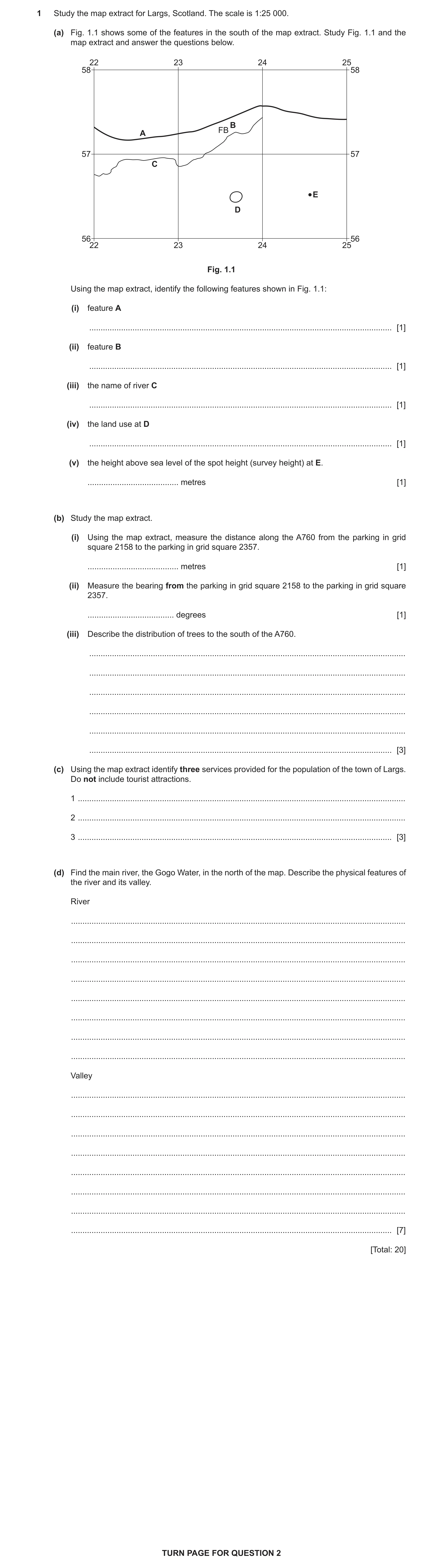
1 Study the map extract for Largs, Scotland. The scale is 1:25 000. (a) Fig. 1.1 shows some of the features in the south of the map extract. Study Fig. 1.1 and the map extract and answer the questions below. 22 23 24 25 58 58 B FB A 57 57 C E D 56 56 22 23 24 25 Fig. 1.1 Using the map extract, identify the following features shown in Fig. 1.1: (i) feature A … [1] (ii) feature B … [1] (iii) the name of river C … [1] (iv) the land use at D … [1] (v) the height above sea level of the spot height (survey height) at E. … metres [1] (b) Study the map extract. (i) Using the map extract, measure the distance along the A760 from the parking in grid square 2158 to the parking in grid square 2357. … metres [1] (ii) Measure the bearing from the parking in grid square 2158 to the parking in grid square 2357. … degrees [1] (iii) Describe the distribution of trees to the south of the A760. … … … … … … [3] (c) Using the map extract identify three services provided for the population of the town of Largs. Do not include tourist attractions. 1 … 2 … 3 … [3] (d) Find the main river, the Gogo Water, in the north of the map. Describe the physical features of the river and its valley. River … … … … … … … … Valley … … … … … … … … [7] [Total: 20] TURN PAGE FOR QUESTION 2
20 marks
Mark scheme: Question Answer Marks 1(a)(i) A760/main road 1 1(a)(ii) Footbridge/building(s)/non–coniferous trees/Fechan/Fechan Bridge. 1 1(a)(iii) Kel Burn 1 1(a)(iv) Coniferous trees/coniferous forest 1 1(a)(v) 344 (metres) 1 1(b)(i) 3000–3200 metres 1 1(b)(ii) 97–103 (degrees) 1 1(b)(iii) Uneven distribution/no pattern/not evenly distributed; 3 More/dense/large amount in W/SW/less/sparse/small amount in E/SE; On steep (area/slope(s))/less/widely dispersed/scattered on flat(ter) land/gentle(r) (area/slope(s)); Along slopes/linear; Mostly below 200 m (accept <100 m for lower value)/very little above 200m; Along/near rivers/tributaries/valleys/glens/burns/valley sides; Parallel/close to coast in SW/grid square 2156; Lower slopes of Ward Hill; Along A760/the road; East of castle (Kelburn)/in Kelburn Glen/River/largest area around Kelburn Glen/grid square 2256. 1(c) School/academy; 3 Hospital; Place of worship/place of worship with spire/minaret/dome; (Allow specific type of place of worship.) Police station; Fire station; Library; Public conveniences/toilets; Club house/golf club/golf course; (Railway) station; Parking; Cemetery; Marina; Recreational route/National Trail; Ferry. 1(d) River: 7 Source in NE/E/mouth in W/NW; Flows to W/from NE/E; (Many, small) tributaries/confluences/affluents (or description e.g., rivers joining); Variable width/gets wider/narrower/widens; 25–35m wide (at its widest); Steep gradient; Meanders/bends/curves/zigzags/winds; Straight(ened) (channel) to the west/as it goes through Largs; Flows across the beach/sand/shingle (at mouth); Waterfall(s). Valley: Steep valley/sides/gorge; Gentle(r)(est) (valley side) in the west/in Largs/lower course/flat in Largs/steeper(est) in middle/upper course; Narrow (valley) floor/bottom; Narrower (valley) in east/upper course/wider in west/lower course; V shaped; Interlocking spurs; Streams running down (valley) sides/tributary valleys/source of tributaries/joins another valley; Meanders/bends/curves/zigzags/winds; Steeper north facing slope; Outcrops/scree/vertical face/cliff.
This question in 0976/22 Oct/Nov 2022
Q9 · Study the map extract for West Kilbride, Scotland 0976/22 May/June 2023
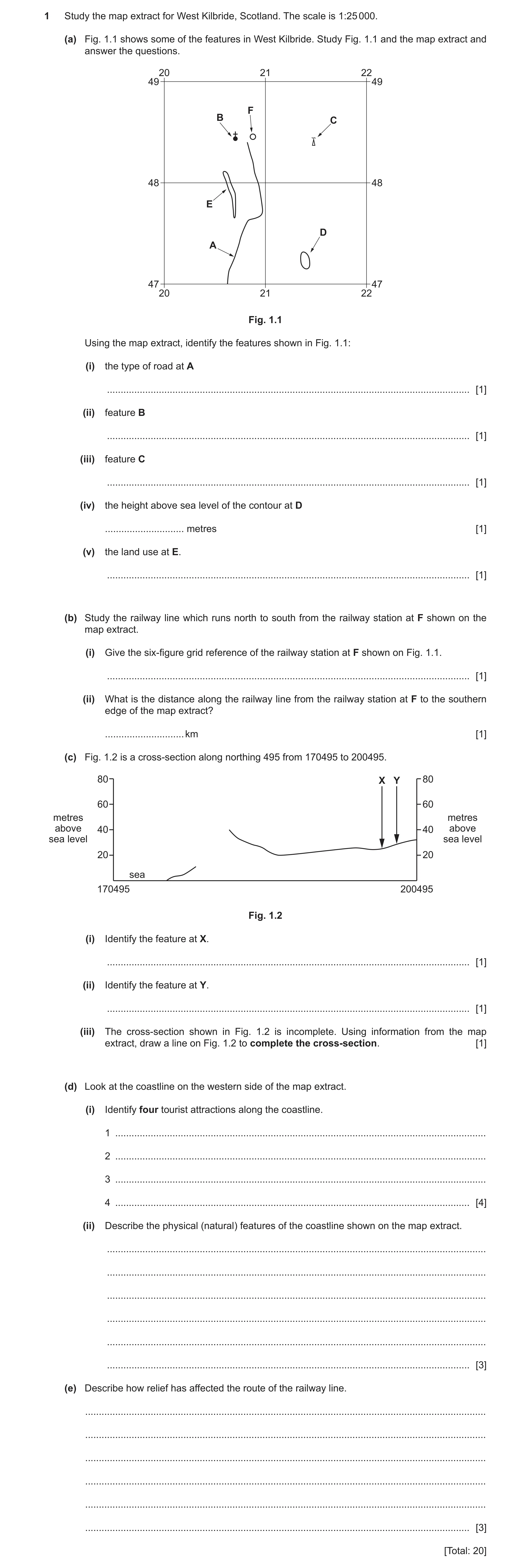
1 Study the map extract for West Kilbride, Scotland. The scale is 1:25 000. (a) Fig. 1.1 shows some of the features in West Kilbride. Study Fig. 1.1 and the map extract and answer the questions. 20 21 22 49 49 F B C 48 48 E D A 47 47 20 21 22 Fig. 1.1 Using the map extract, identify the features shown in Fig. 1.1: (i) the type of road at A … [1] (ii) feature B … [1] (iii) feature C … [1] (iv) the height above sea level of the contour at D … metres [1] (v) the land use at E. … [1] (b) Study the railway line which runs north to south from the railway station at F shown on the map extract. (i) Give the six‑figure grid reference of the railway station at F shown on Fig. 1.1. … [1] (ii) What is the distance along the railway line from the railway station at F to the southern edge of the map extract? … km [1] (c) Fig. 1.2 is a cross‑section along northing 495 from 170495 to 200495. 80 X Y 80 60 60 metres metres above 40 40 above sea level sea level 20 20 sea 170495 200495 Fig. 1.2 (i) Identify the feature at X. … [1] (ii) Identify the feature at Y. … [1] (iii) The cross‑section shown in Fig. 1.2 is incomplete. Using information from the map extract, draw a line on Fig. 1.2 to complete the cross‑section. [1] (d) Look at the coastline on the western side of the map extract. (i) Identify four tourist attractions along the coastline. 1 … 2 … 3 … 4 … [4] (ii) Describe the physical (natural) features of the coastline shown on the map extract. … … … … … … [3] (e) Describe how relief has affected the route of the railway line. … … … … … … [3] [Total: 20]
20 marks
Mark scheme: Question Answer Marks 1(a)(i) B road/secondary road/B7047. 1 1(a)(ii) Church/place of worship with spire/minaret/dome. 1 1(a)(iii) Mast. 1 1(a)(iv) 85 (metres). 1 1(a)(v) Non-coniferous trees/woods/forest/vegetation. 1 1(b)(i) 208/9483/4. 1 1(b)(ii) 2.53 (km) (accept 2.4–2.6 km or 2400–2600 m). 1 1(c)(i) (Carlung) farm/building(s)/other road/drive/track. 1 1(c)(ii) A road/A78/main road. 1 1(c)(iii) Rises to a hill at/just above 60 m above sea level (allow 55–64 m). 1 1(d)(i) Castle; 4 Pier; Picnic site; Golf Club/course; Coastal path/National Trail/Recreational route; Public house/pub; Hotel; Beach. 1(d)(ii) Island(s)/rocks (in sea)/offshore rocks/stack(s)/stump(s)/craig/crag; 3 Sand(y)/sand & shingle/beach(es); Loose rock(s)/boulders/(rock) outcrop/wave-cut platform; Headland; Bay; Raised beach; Cliff/vertical face; (Jenny’s) dyke/(Sandy’s) creek. 1(e) Follows/along/through valley/on valley floor; 3 (Height mark) keeps to low(er) land/base of hills/avoids high(er) land/curves around/along the side of/avoids hill(s); (Gradient mark) keeps to gentle gradient/flatter land/on flat land between Drummilling and Law Hill/curves around/avoids steep(er) slopes/parallel to slopes; Follows coastline in the south.
This question in 0976/22 May/June 2023
Q10 · Study the map extract for Olang Valdaora, Italy 0976/22 Oct/Nov 2024
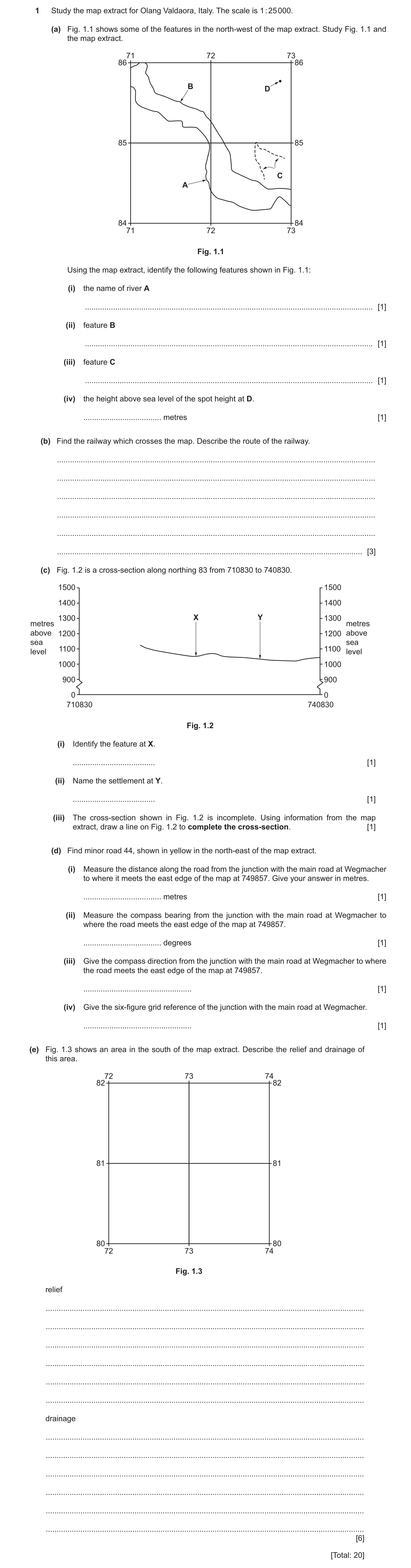
1 Study the map extract for Olang Valdaora, Italy. The scale is 1 : 25 000. (a) Fig. 1.1 shows some of the features in the north-west of the map extract. Study Fig. 1.1 and the map extract. 71 72 73 86 86 B D 85 85 C A 84 84 71 72 73 Fig. 1.1 Using the map extract, identify the following features shown in Fig. 1.1: (i) the name of river A … [1] (ii) feature B … [1] (iii) feature C … [1] (iv) the height above sea level of the spot height at D. … metres [1] (b) Find the railway which crosses the map. Describe the route of the railway. … … … … … … [3] (c) Fig. 1.2 is a cross-section along northing 83 from 710830 to 740830. 1500 1500 1400 1400 1300 X Y 1300 metres metres above 1200 1200 above sea sea 1100 1100level level 1000 1000 900 900 0 0 710830 740830 Fig. 1.2 (i) Identify the feature at X. … [1] (ii) Name the settlement at Y. … [1] (iii) The cross-section shown in Fig. 1.2 is incomplete. Using information from the map extract, draw a line on Fig. 1.2 to complete the cross-section. [1] (d) Find minor road 44, shown in yellow in the north-east of the map extract. (i) Measure the distance along the road from the junction with the main road at Wegmacher to where it meets the east edge of the map at 749857. Give your answer in metres. … metres [1] (ii) Measure the compass bearing from the junction with the main road at Wegmacher to where the road meets the east edge of the map at 749857. … degrees [1] (iii) Give the compass direction from the junction with the main road at Wegmacher to where the road meets the east edge of the map at 749857. … [1] (iv) Give the six-figure grid reference of the junction with the main road at Wegmacher. … [1] (e) Fig. 1.3 shows an area in the south of the map extract. Describe the relief and drainage of this area. 72 73 74 82 82 81 81 80 80 72 73 74 Fig. 1.3 relief … … … … … … drainage … … … … … … [6] [Total: 20]
20 marks
Mark scheme: Question Answer Marks 1(a)(i) (F.) Rienza 1 1(a)(ii) Main road/49 1 1(a)(iii) Path with signs 1 1(a)(iv) 1412 (metres) 1 1(b) North-west – south-east/east or vice-versa OR travels NW/SE/E/ESE; (NOTE 3 where a series of directions are given take the first and last. If only one direction given, it must be the direction it is going to.) Winding/bends/zigzag/curves/meanders; In valley; On lowland/avoids hills; On flatter/gentle(r)/avoids steep(er) land; Passes Niederolang/passes through/by/goes to Niederolang/a settlement in 7283/passes by/near/to the north of Olang Valdaora/Mitterolang; Crosses/goes above/under/through bridges OR goes over/under roads/over rivers; Follows course of river/along/near river/S/SW of river. 1(c)(i) River or stream/Rio Furcia/Furkelbach/other road/path/minor road 1 1(c)(ii) Mitterolang/Valdaora di mezzo/Moar/Tharer or Maier Moar Tharer 1 1(c)(iii) Land rising steadily to above 1350 m but below 1450 m; 1 (NOTE should touch the left-hand axis. Allow a slight hump/dip.) 1(d)(i) 1750–2000(metres) 1 1(d)(ii) 28–30 (degrees) 1 1(d)(iii) North north-east 1 1(d)(iv) 741 841 1 1(e) Relief 6 High/upland/mountain/hilly; (NOTE allow hill/mountainous) Steep OR gentle(r) to the north/steep(er) to the south; Spur(s); V-shaped valleys/small valleys; Highest point 1780–1799 m; Lowest point 1100–1108 m; Lower in north/higher in south/descending to north; North facing; Cliff. Drainage Small river(s)/stream(s); Tributary(ies)/confluence(s) Flow N/NE; Spring(s); Intermittent stream(s). NOTE Reserve 2 marks for relief and 2 marks for drainage.
This question in 0976/22 Oct/Nov 2024
Question 11 0976/22 Oct/Nov 2024
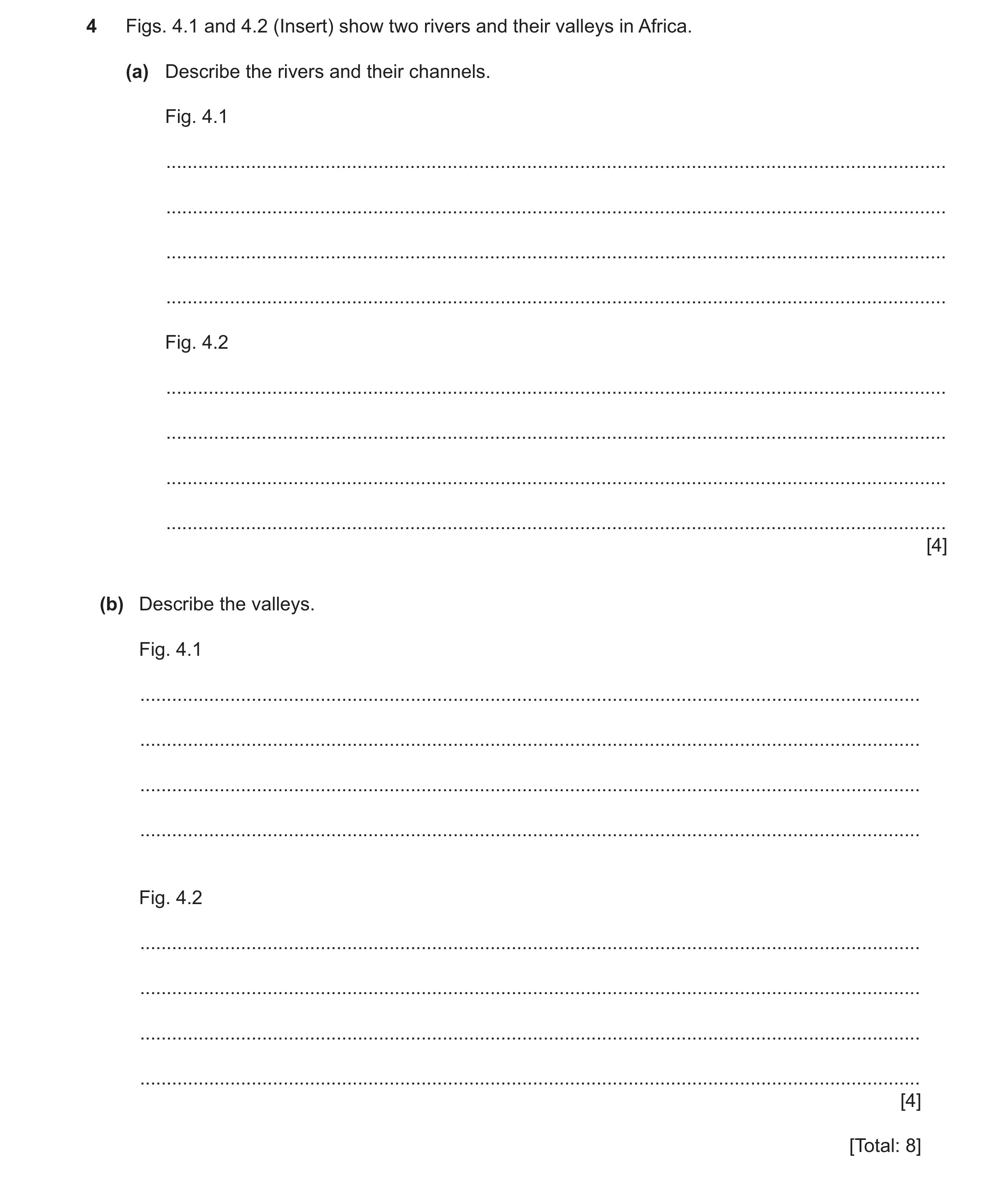
4 Figs. 4.1 and 4.2 (Insert) show two rivers and their valleys in Africa. (a) Describe the rivers and their channels. Fig. 4.1 … … … … Fig. 4.2 … … … … [4] (b) Describe the valleys. Fig. 4.1 … … … … Fig. 4.2 … … … … [4] [Total: 8]
8 marks
Mark scheme: 4(a) Fig. 4.1 Rivers and channels 4 Meandering/winding; Sandy; Variable width (river); Low flow/discharge/slow flow; Wide/broad/space available for higher discharge/for river to widen; Shallow; Flat/gentle (gradient) Slip-off slopes. Fig. 4.2 Rivers and channels Rocky/boulders/flows around rock; Steep (gradient); Variable width (river) Fast flowing/rapids; Island/divides and rejoins/splits or divides into two channels/eyot; Narrow; Shallow; Pools. NOTE This is not a comparison question so do not accept comparatives. Reserve one mark for each photograph. 4(b) Fig. 4.1 valley 4 Flood plain/plain; Wide; Flat/gentle; Grass/savanna/prairie/bushes. Fig. 4.2 valley Narrow; V shaped; Steep (sides)/deep; Spurs; Rocky/rocks (sides/rock outcrops); Trees/forest. NOTE This is not a comparison question so do not accept comparatives. Reserve one mark for each photograph.
This question in 0976/22 Oct/Nov 2024
 10 / 28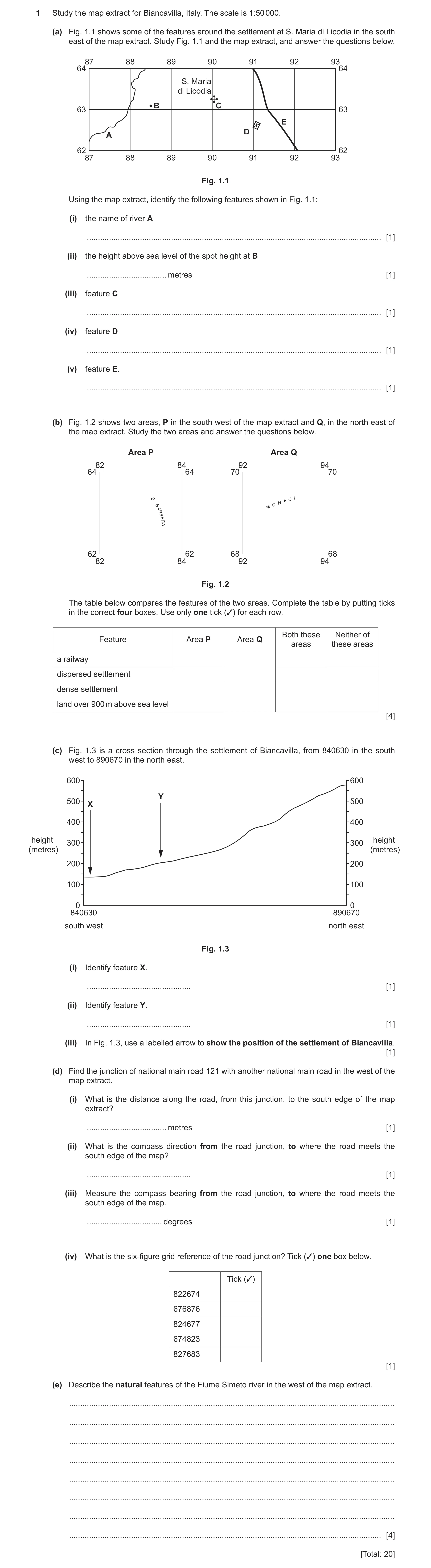
 28 / 28
 20
20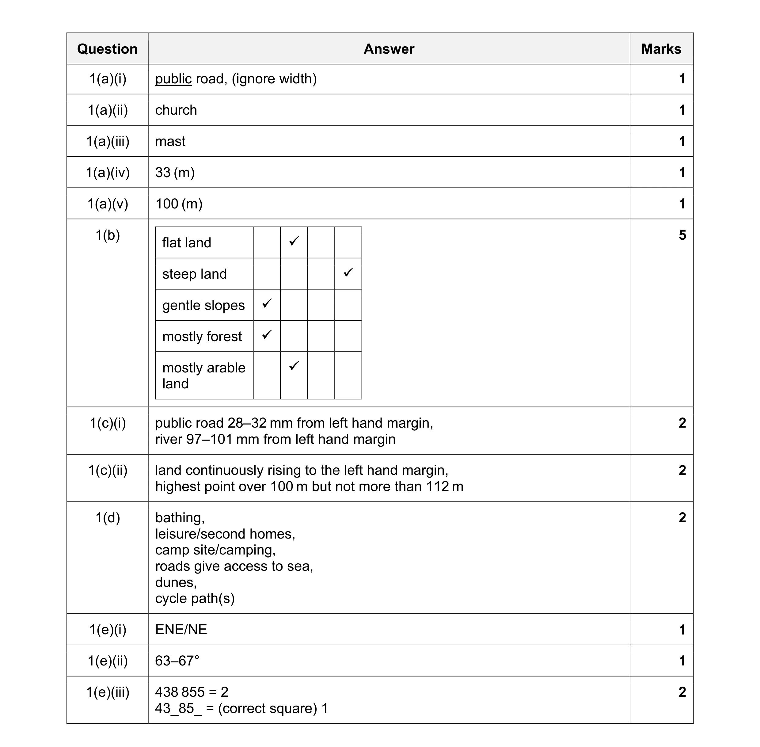 20
20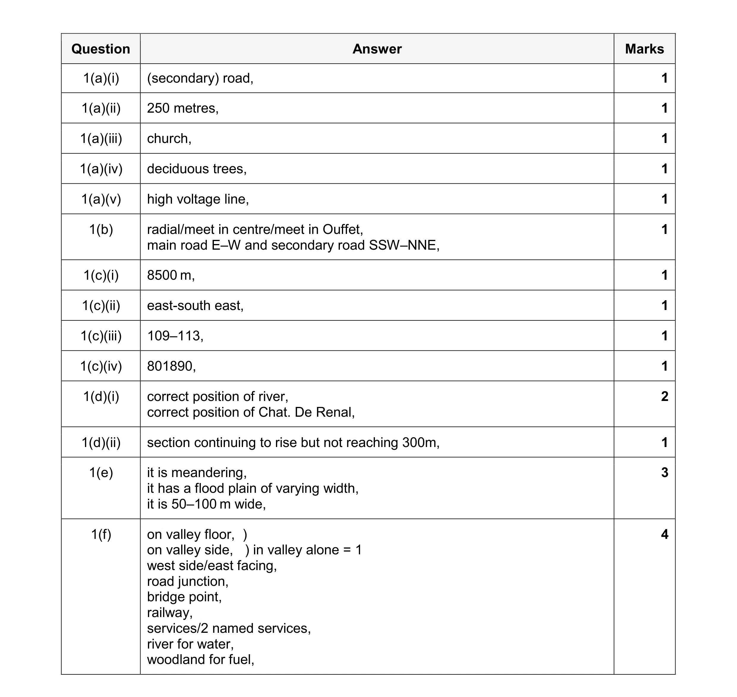 20
20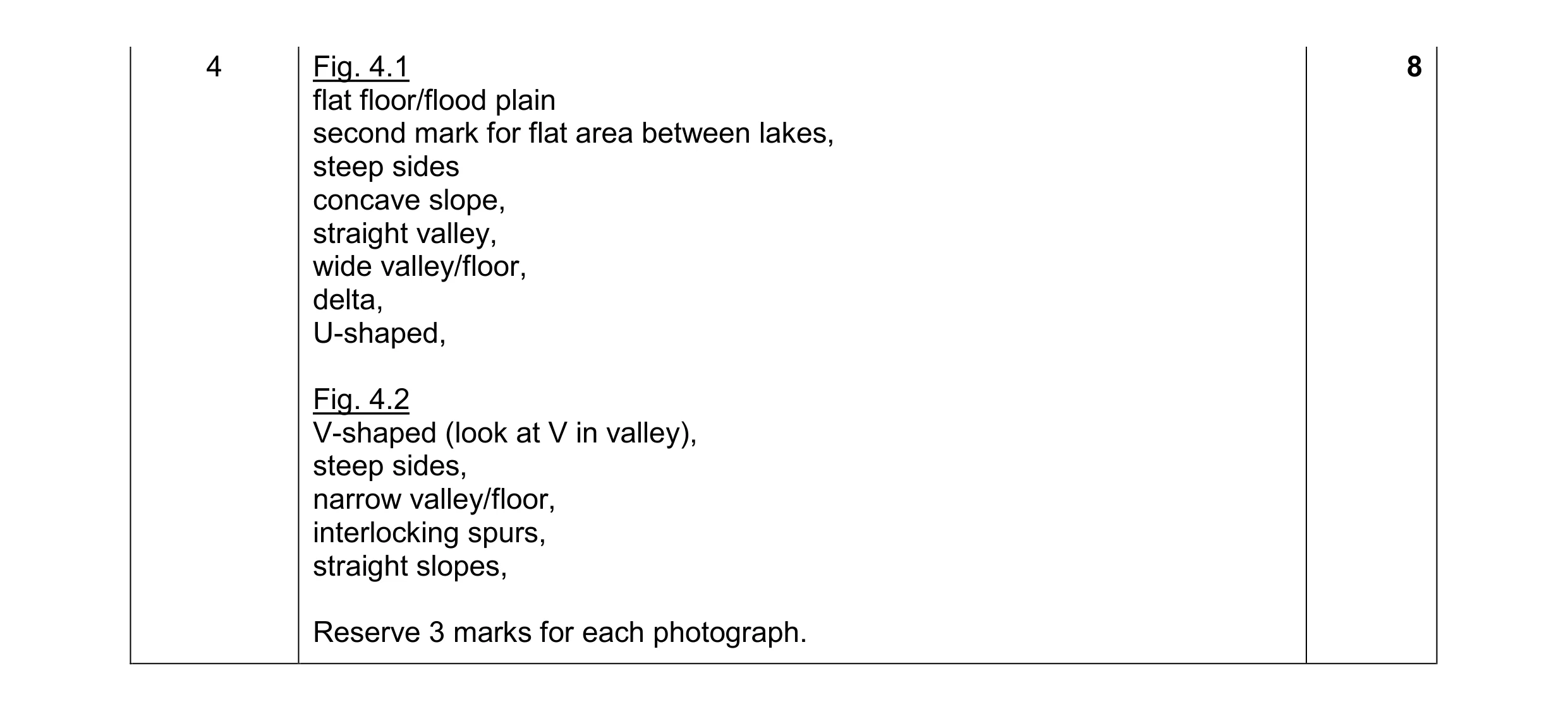 8
8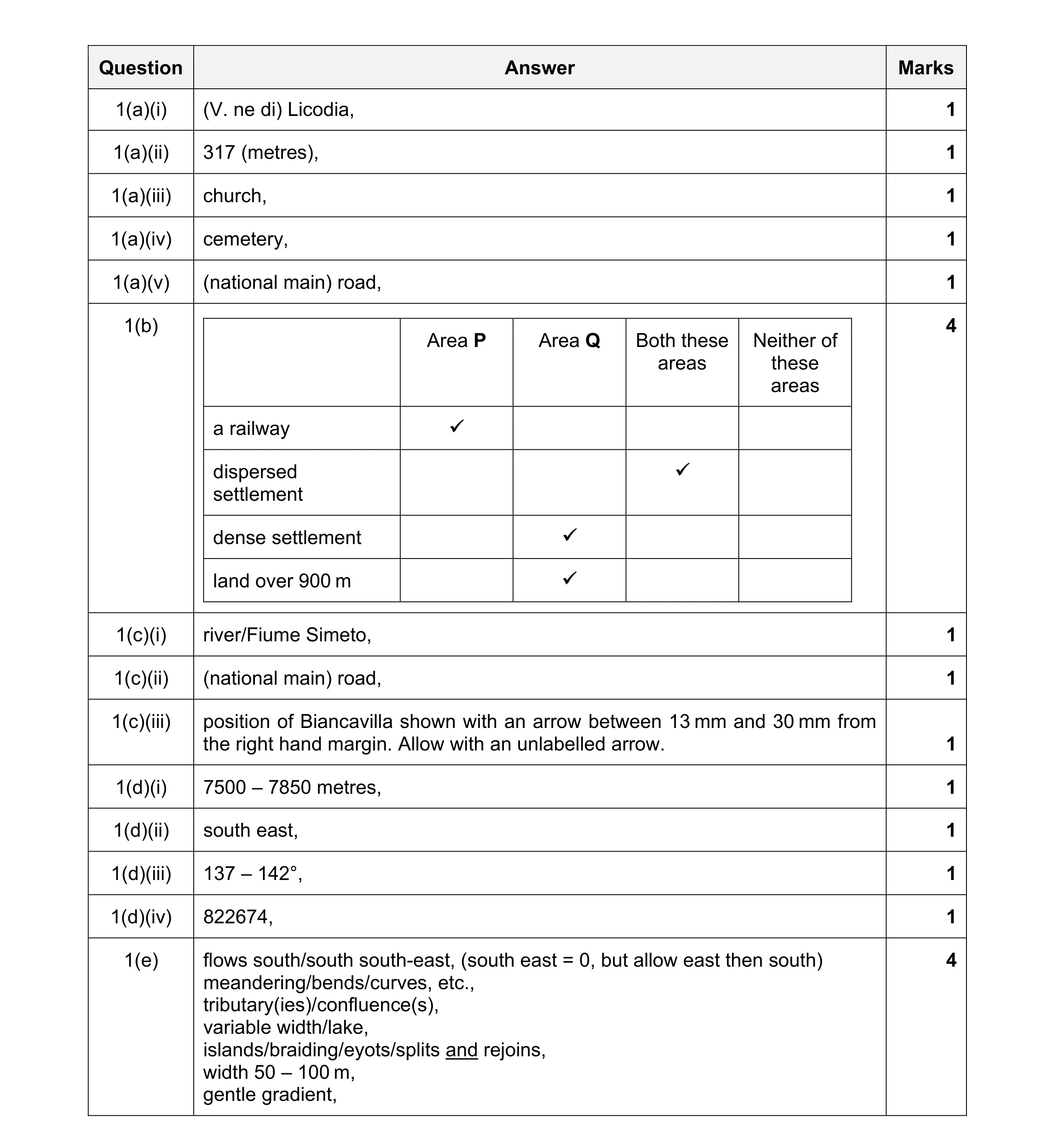 20
20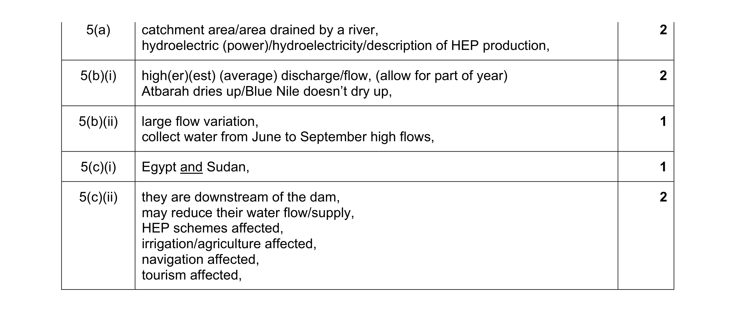 8
8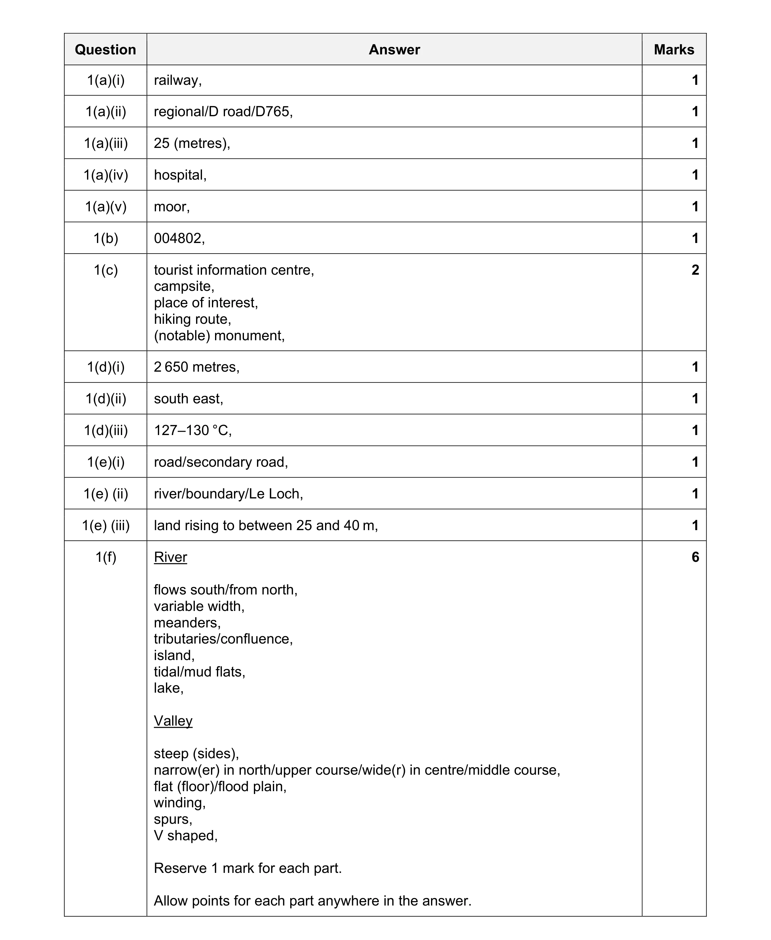 20
20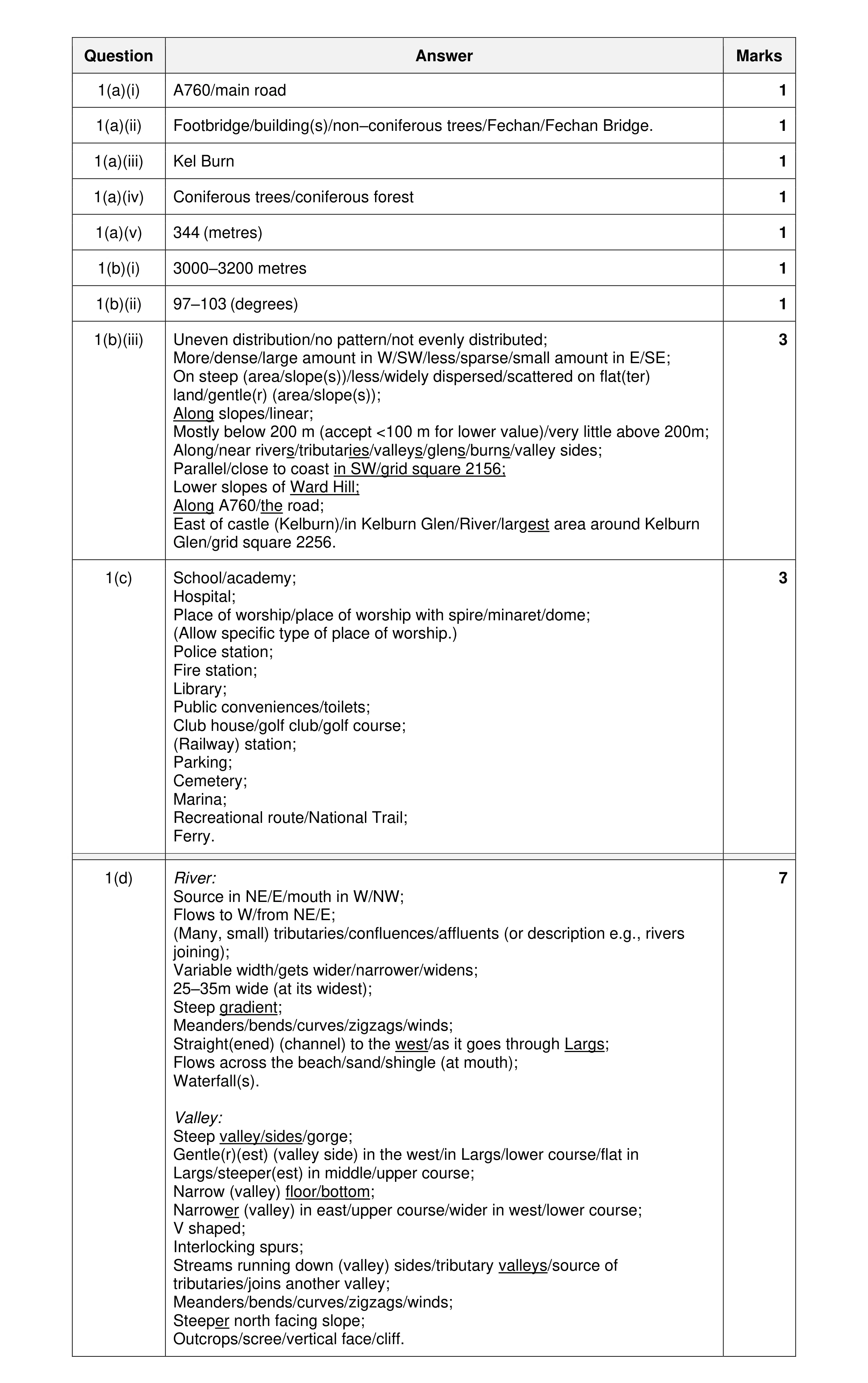 20
20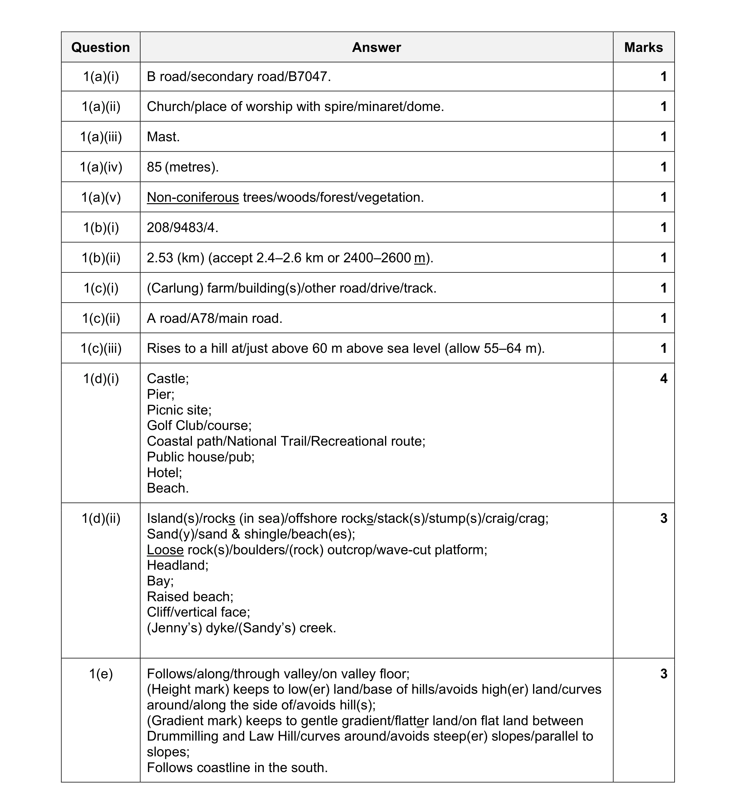 20
20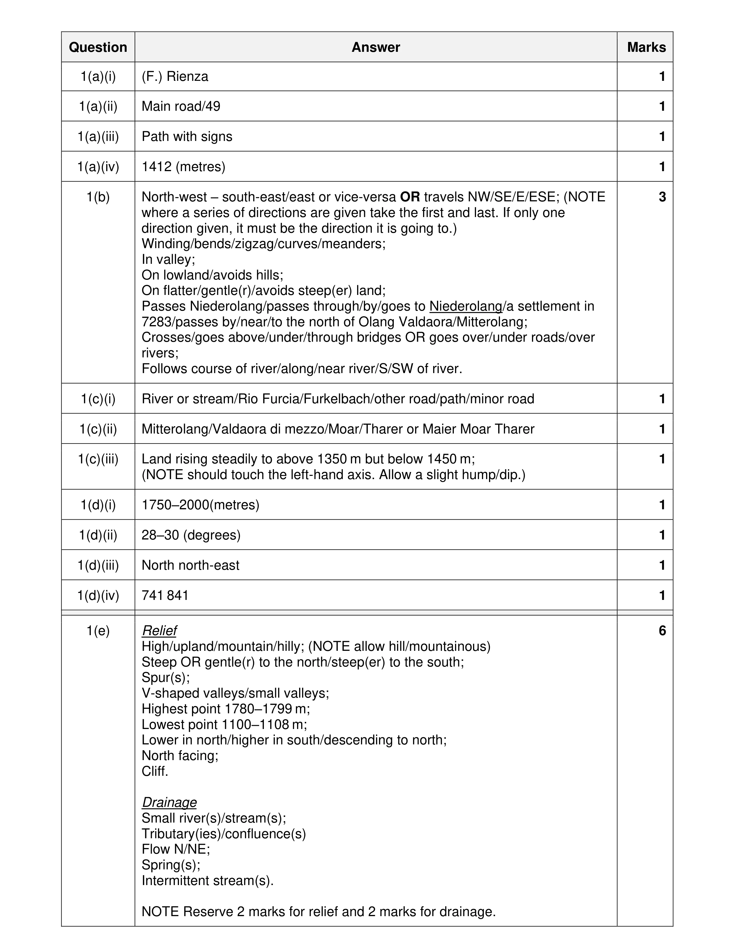 20
20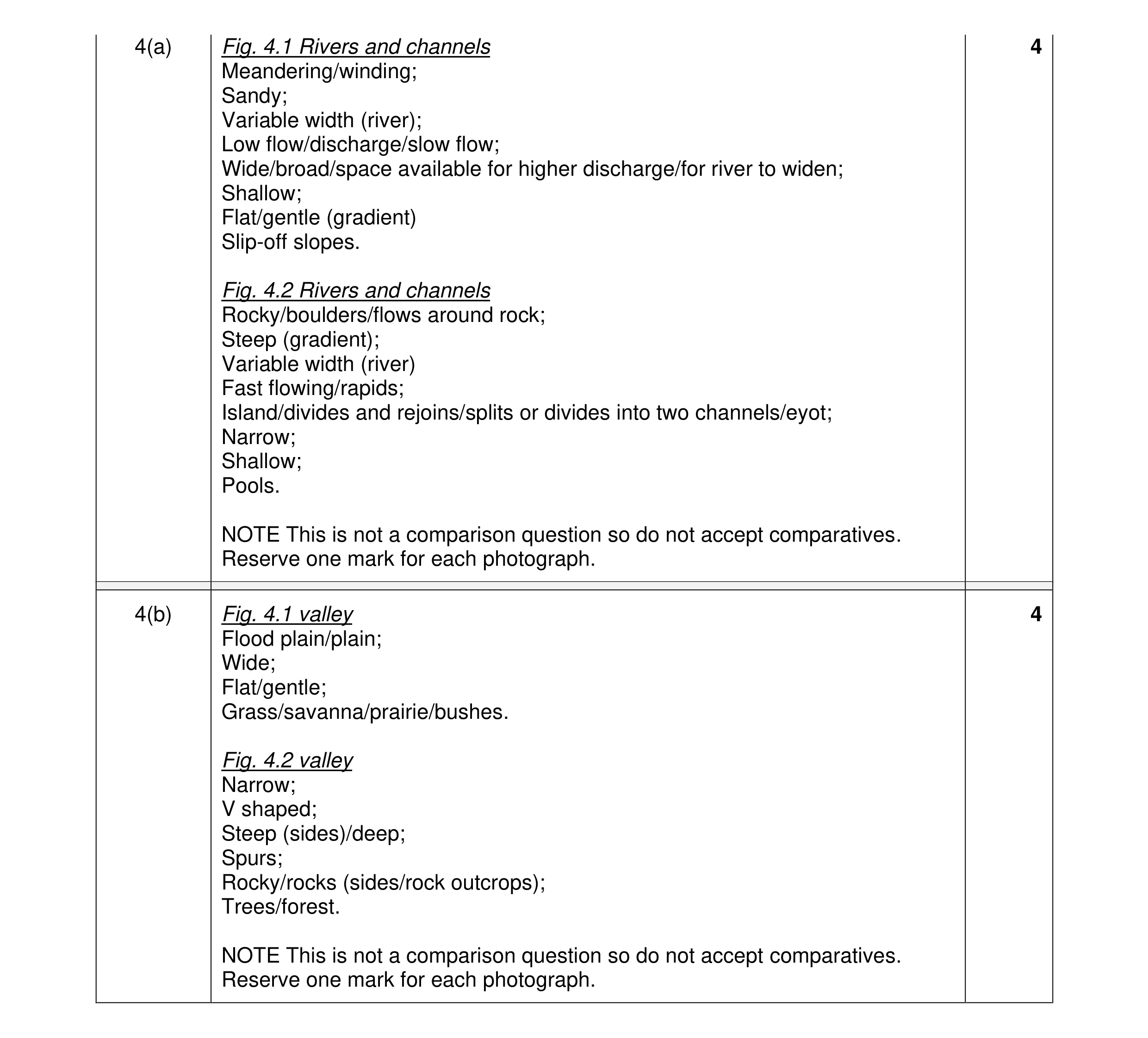 8
8