Cambridge IGCSE Geography (9-1) 0976 — 2021 May/June Paper 1 · Variant 2
0976/12/M/J/21 · 75 marks · ≈84 min
The question paper and its mark scheme, free to read here and free to download. This is Cambridge’s own paper, exactly as it was sat.
Question paper32 pages





Mark scheme18 pages
Answers below. Sit the paper first if you are practising.
Paper as text
Question paper, page 1
This document has 32 pages. Any blank pages are indicated. Cambridge IGCSE™(9–1) DC (LK) 213521 © UCLES 2021 [Turn over GEOGRAPHY 0976/12 Paper 1 Geographical Themes May/June 2021 1 hour 45 minutes You must answer on the question paper. You will need: Insert (enclosed) Calculator Ruler INSTRUCTIONS ● Answer three questions in total, one from each section. ● Use a black or dark blue pen. You may use an HB pencil for any diagrams or graphs. ● Write your name, centre number and candidate number in the boxes at the top of the page. ● Write your answer to each question in the space provided. ● Do not use an erasable pen or correction fluid. ● Do not write on any bar codes. ● If additional space is needed, you should use the lined pages at the end of this booklet; the question number or numbers must be clearly shown. INFORMATION ● The total mark for this paper is 75. ● The number of marks for each question or part question is shown in brackets [ ]. ● The insert contains additional resources referred to in the questions. Definitions MEDCs – More Economically Developed Countries LEDCs – Less Economically Developed Countries * 6 7 4 9 6 3 8 0 1 8 *
Question paper, page 2
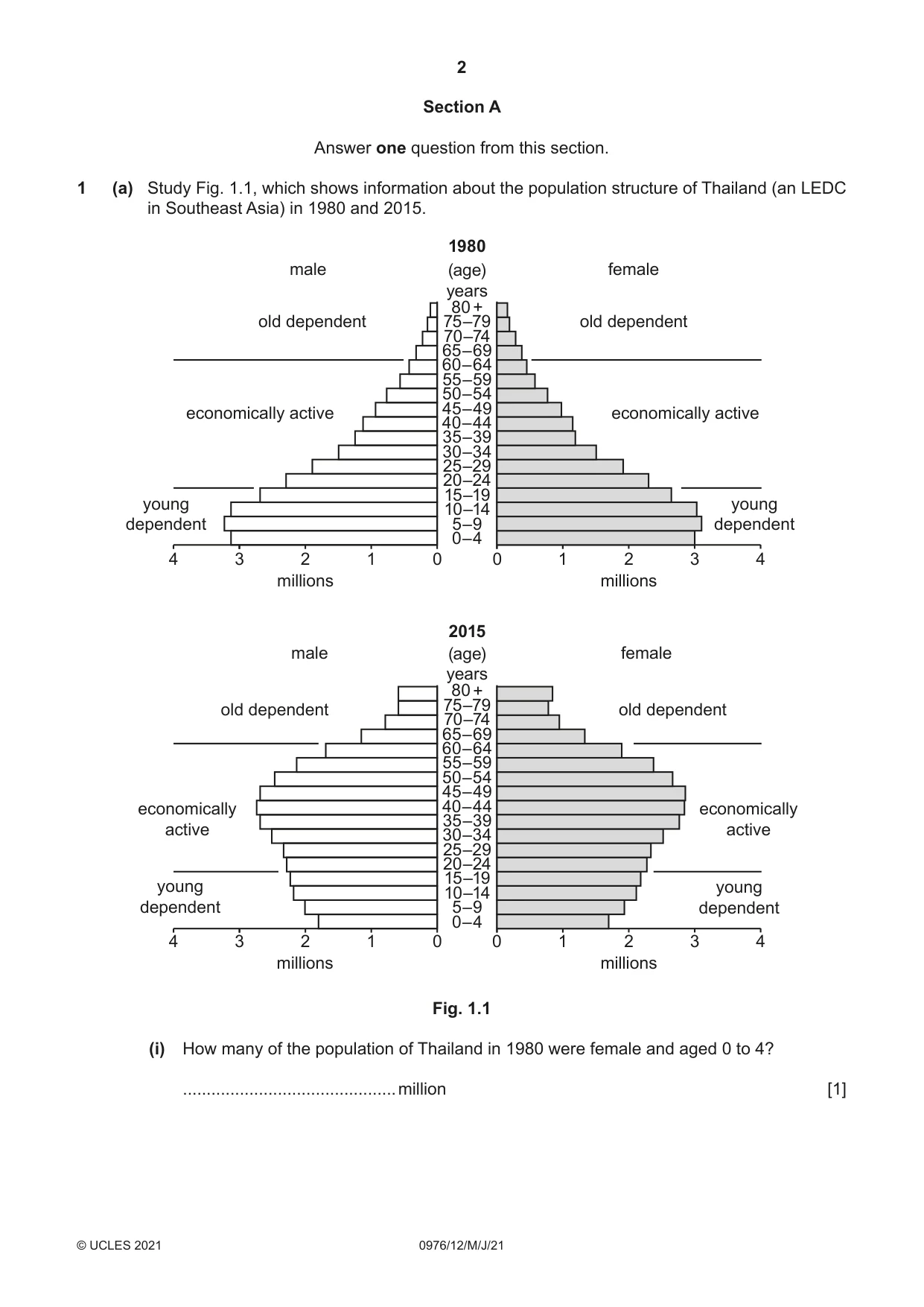
2 0976/12/M/J/21 © UCLES 2021 Section A Answer one question from this section. 1 (a) Study Fig. 1.1, which shows information about the population structure of Thailand (an LEDC in Southeast Asia) in 1980 and 2015. 0 1 2 millions millions 0–4 5–9 10–14 15–19 20–24 25–29 30–34 35–39 40–44 45–49 50–54 55–59 60–64 65–69 70–74 75–79 80 + male male female female (age) years 1980 2015 3 4 0 1 2 3 4 0 1 2 millions millions 0–4 5–9 10–14 15–19 20–24 25–29 30–34 35–39 40–44 45–49 50–54 55–59 60–64 65–69 70–74 75–79 80 + (age) years 3 4 0 1 2 3 4 old dependent old dependent old dependent old dependent economically active economically active economically active economically active young dependent young dependent young dependent young dependent Fig. 1.1 (i) How many of the population of Thailand in 1980 were female and aged 0 to 4? … million [1]
Question paper, page 3
3 0976/12/M/J/21 © UCLES 2021 [Turn over (ii) Describe how the total population of Thailand aged 0 to 4 changed between 1980 and 2015. You should use statistics in your answer. … … … … [2] (iii) Describe how the shape of Thailand’s population pyramid changed between 1980 and 2015. … … … … … … [3] (iv) Suggest reasons for the decrease in the number of young dependents in Thailand between 1980 and 2015. … … … … … … … … [4]
Question paper, page 4
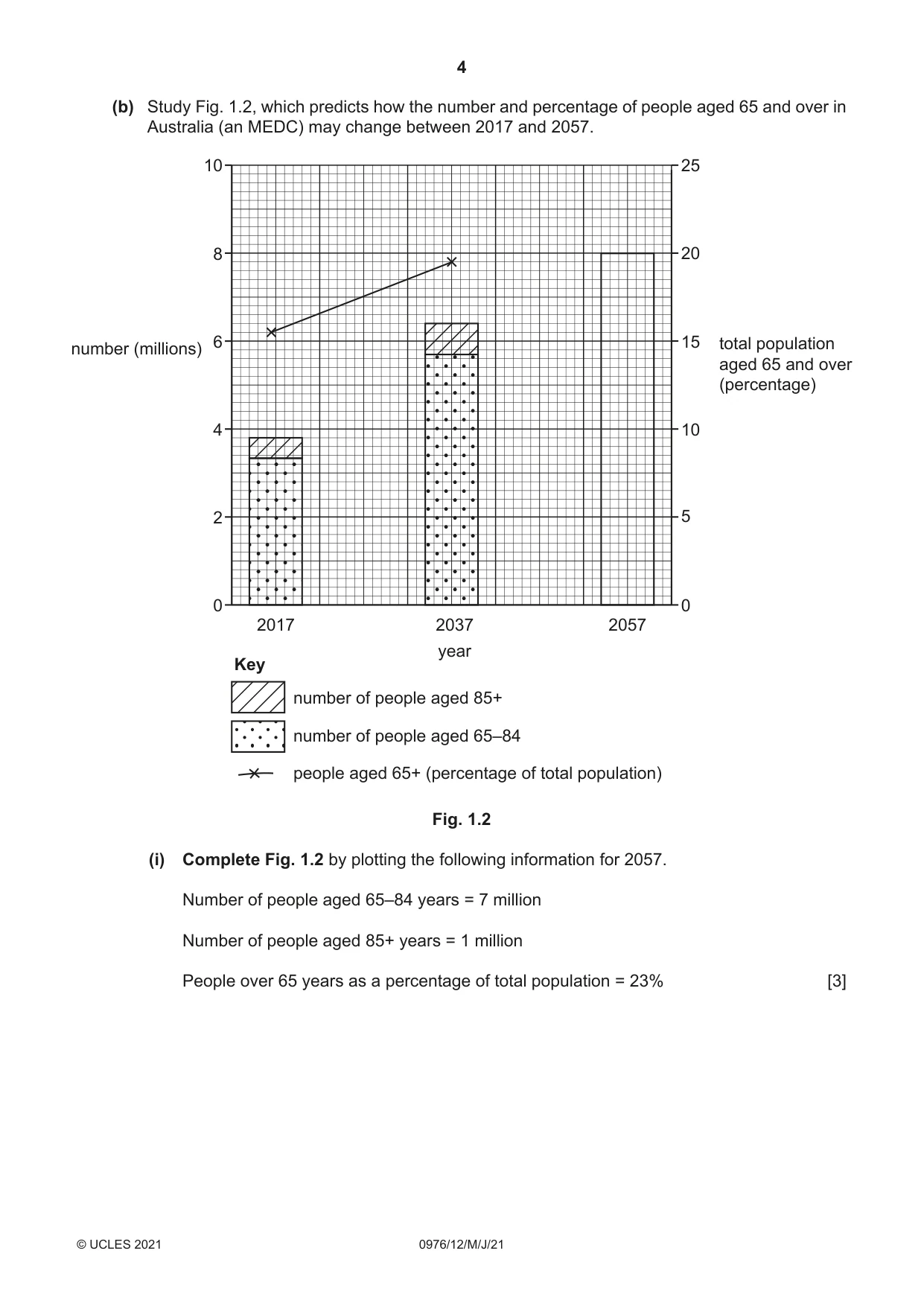
4 0976/12/M/J/21 © UCLES 2021 (b) Study Fig. 1.2, which predicts how the number and percentage of people aged 65 and over in Australia (an MEDC) may change between 2017 and 2057. 0 0 5 10 15 number (millions) 20 25 2 4 6 8 10 2017 2037 2057 total population aged 65 and over (percentage) year number of people aged 85+ people aged 65+ (percentage of total population) number of people aged 65–84 Key Fig. 1.2 (i) Complete Fig. 1.2 by plotting the following information for 2057. Number of people aged 65–84 years = 7 million Number of people aged 85+ years = 1 million People over 65 years as a percentage of total population = 23% [3]
Question paper, page 5
5 0976/12/M/J/21 © UCLES 2021 [Turn over (ii) Explain why increasing numbers of people aged 65 and over may cause problems for MEDCs, such as Australia. … … … … … … … … … … [5]
Question paper, page 6
6 0976/12/M/J/21 © UCLES 2021 (c) For a named country you have studied, describe the causes and consequences of under-population. Name of country … … … … … … … … … … … … … … … … … … … … … … … … … … [7] [Total: 25]
Question paper, page 7
7 0976/12/M/J/21 © UCLES 2021 [Turn over 2 (a) Study Fig. 2.1 (Insert), which shows information about urbanisation. (i) Define the term urbanisation. … … [1] (ii) Using Fig. 2.1 only, name: – the continent which has most cities with a population of 10 million or more … – the continent where there are no cities with a population of over 5 million. … [2] (iii) Using Fig. 2.1 only, describe the distribution of areas with over 80% of their population living in urban areas. … … … … … … [3] (iv) Explain why the percentage of the total population living in cities in LEDCs is likely to continue growing rapidly. … … … … … … … … [4]
Question paper, page 8
8 0976/12/M/J/21 © UCLES 2021 (b) Study Figs. 2.2 and 2.3 (Insert), which are photographs taken in part of the urban area of Mumbai, India (an LEDC). (i) Describe three features of the buildings in the area shown in Fig. 2.2. 1 … … 2 … … 3 … … [3] (ii) Explain why the quality of life of some people who have moved to areas like those shown in both Figs. 2.2 and 2.3 may be worse than in the rural areas they moved from. … … … … … … … … … … [5]
Question paper, page 9
9 0976/12/M/J/21 © UCLES 2021 [Turn over (c) For a named urban area you have studied, describe what has been done to reduce the problems caused by urban growth. Name of urban area … … … … … … … … … … … … … … … … … … … … … … … … … … [7] [Total: 25]
Question paper, page 10
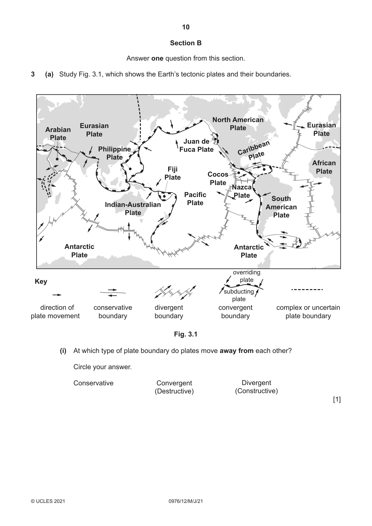
10 0976/12/M/J/21 © UCLES 2021 Section B Answer one question from this section. 3 (a) Study Fig. 3.1, which shows the Earth’s tectonic plates and their boundaries. Indian-Australian Plate Juan de Fuca Plate Cocos Plate Fiji Plate Antarctic Plate African Plate Eurasian Plate Caribbean Plate South American Plate Nazca Plate Nazca Plate Nazca Plate Pacific Plate Southeast Southwest Indian Ridge North American Plate Eurasian Plate Antarctic Plate Philippine Plate conservative boundary divergent boundary convergent boundary overriding plate subducting plate complex or uncertain plate boundary direction of plate movement Key Arabian Plate Fig. 3.1 (i) At which type of plate boundary do plates move away from each other? Circle your answer. Conservative Convergent (Destructive) Divergent (Constructive) [1]
Question paper, page 11
11 0976/12/M/J/21 © UCLES 2021 [Turn over (ii) Explain why boundaries where plates move towards each other are known as destructive boundaries. … … … … [2] (iii) Explain why volcanoes form at places where plates move away from each other. … … … … … … [3] (iv) Draw a diagram of a strato-volcano (composite cone) in the box below and label its main features. [4]
Question paper, page 12
12 0976/12/M/J/21 © UCLES 2021 (b) Study Fig. 3.2 (Insert), which shows information about an eruption of Mauna Loa volcano in Hawaii. (i) Compare the flow of lava from Mokuaweoweo crater (labelled M on Fig. 3.2) with the flow from Pu’u Ula’ula crater (labelled P). … … … … … … [3] (ii) Explain why more deaths and injuries are caused by earthquakes than by volcanic eruptions. … … … … … … … … … … [5]
Question paper, page 13
13 0976/12/M/J/21 © UCLES 2021 [Turn over (c) For a named area which you have studied, explain the causes of an earthquake. Name of area … … … … … … … … … … … … … … … … … … … … … … … … … … [7] [Total: 25]
Question paper, page 14
14 0976/12/M/J/21 © UCLES 2021 4 (a) Study Fig. 4.1, which shows a map of an upland area, and Fig. 4.2 (Insert), which is a photograph of a waterfall. hard rock river direction of flow A B C D N 0 5 10 15 km Key Fig. 4.1 (i) Which location A, B, C or D is the most likely position of the waterfall shown in Fig. 4.2? … [1] (ii) Identify features X and Y in Fig. 4.2. X … Y … [2] (iii) Explain why a gorge may form downstream of a waterfall. … … … … … … [3]
Question paper, page 15
15 0976/12/M/J/21 © UCLES 2021 [Turn over (b) Study Fig. 4.3 (Insert), which is a map of an area in Asia where river flooding occurred. (i) Describe the location of the areas shown in Fig. 4.3 where flooding occurred. … … … … … … [3] (ii) Suggest reasons why the rivers flooded in the areas shown in Fig. 4.3. … … … … … … … … [4]
Question paper, page 16
16 0976/12/M/J/21 © UCLES 2021 (iii) Suggest the methods which could be used in the area shown in Fig. 4.3 to prevent flooding. … … … … … … … … … … [5]
Question paper, page 17
17 0976/12/M/J/21 © UCLES 2021 [Turn over (c) Describe the changes which occur along a river and its valley from its source to its mouth. You should refer to processes and landforms. … … … … … … … … … … … … … … … … … … … … … … … … … [7] [Total: 25]
Question paper, page 18
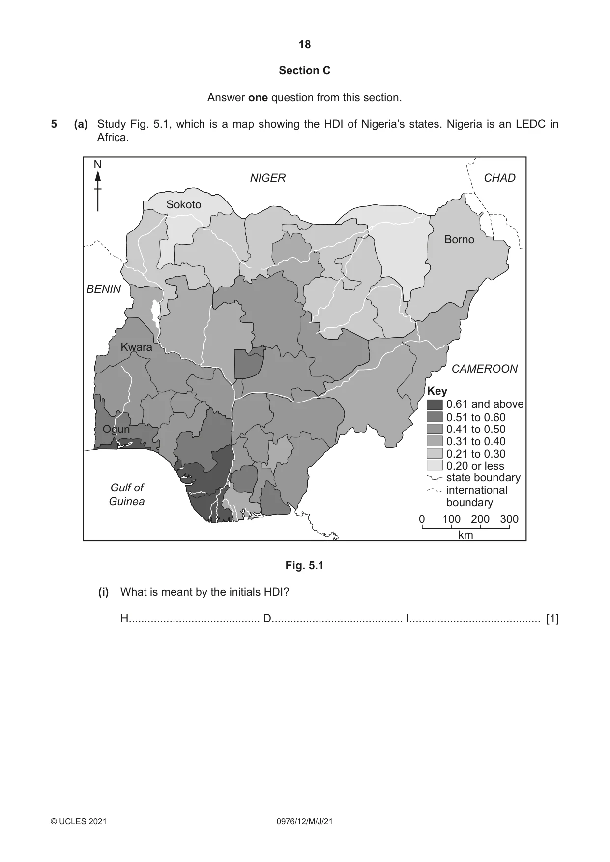
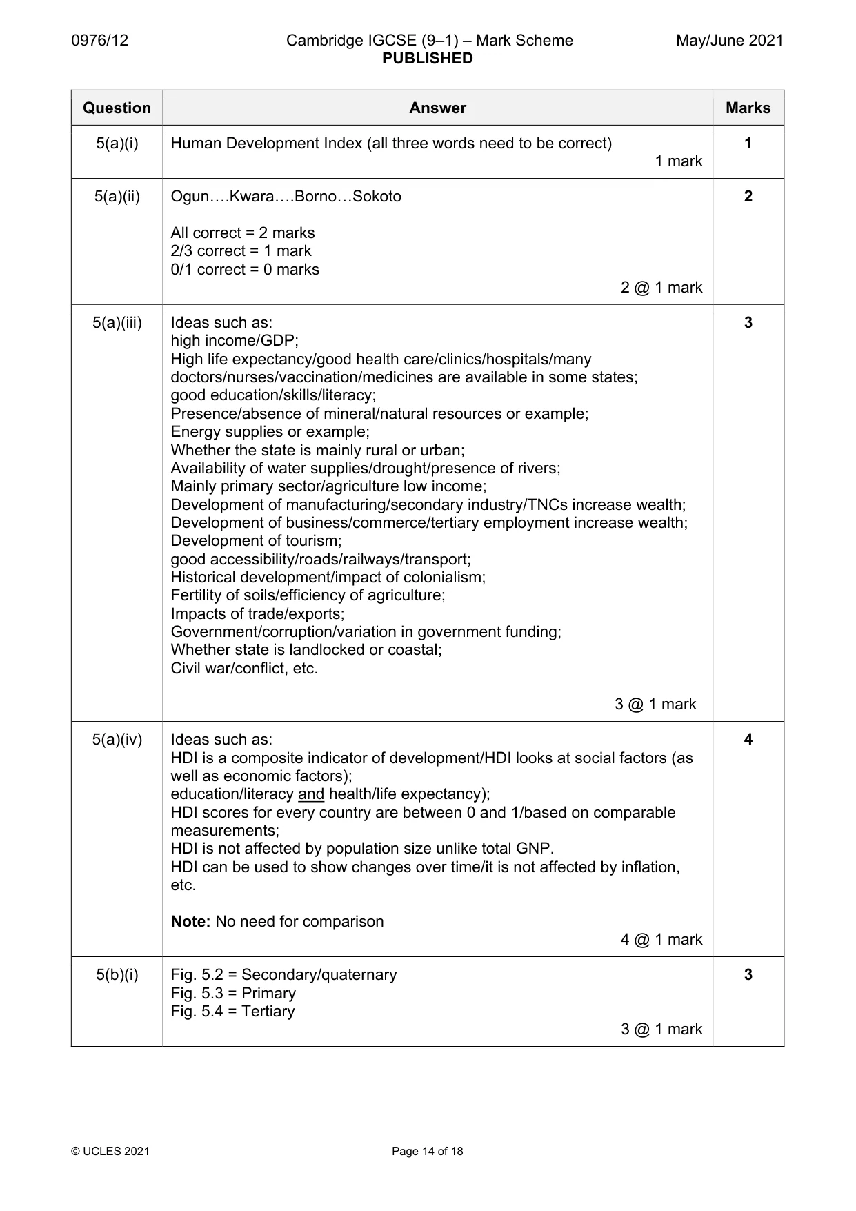
18 0976/12/M/J/21 © UCLES 2021 Section C Answer one question from this section. 5 (a) Study Fig. 5.1, which is a map showing the HDI of Nigeria’s states. Nigeria is an LEDC in Africa. Gulf of Guinea Sokoto NIGER CHAD CAMEROON 0 100 200 300 km N Key BENIN 0.61 and above 0.51 to 0.60 0.41 to 0.50 0.31 to 0.40 0.21 to 0.30 0.20 or less international boundary Kwara Borno Ogun state boundary Fig. 5.1 (i) What is meant by the initials HDI? H… D… I… [1]
Question paper, page 19
19 0976/12/M/J/21 © UCLES 2021 [Turn over (ii) Put the following states in rank order according to their HDI. Borno Kwara Ogun Sokoto 1st … highest HDI 2nd … 3rd … 4th … lowest HDI [2] (iii) Suggest three reasons why some states of Nigeria have a higher HDI than other states. 1 … … 2 … … 3 … … [3] (iv) Explain why HDI is considered to be a better indicator of the level of development of a country than its Gross National Product (GNP). … … … … … … … … [4]
Question paper, page 20
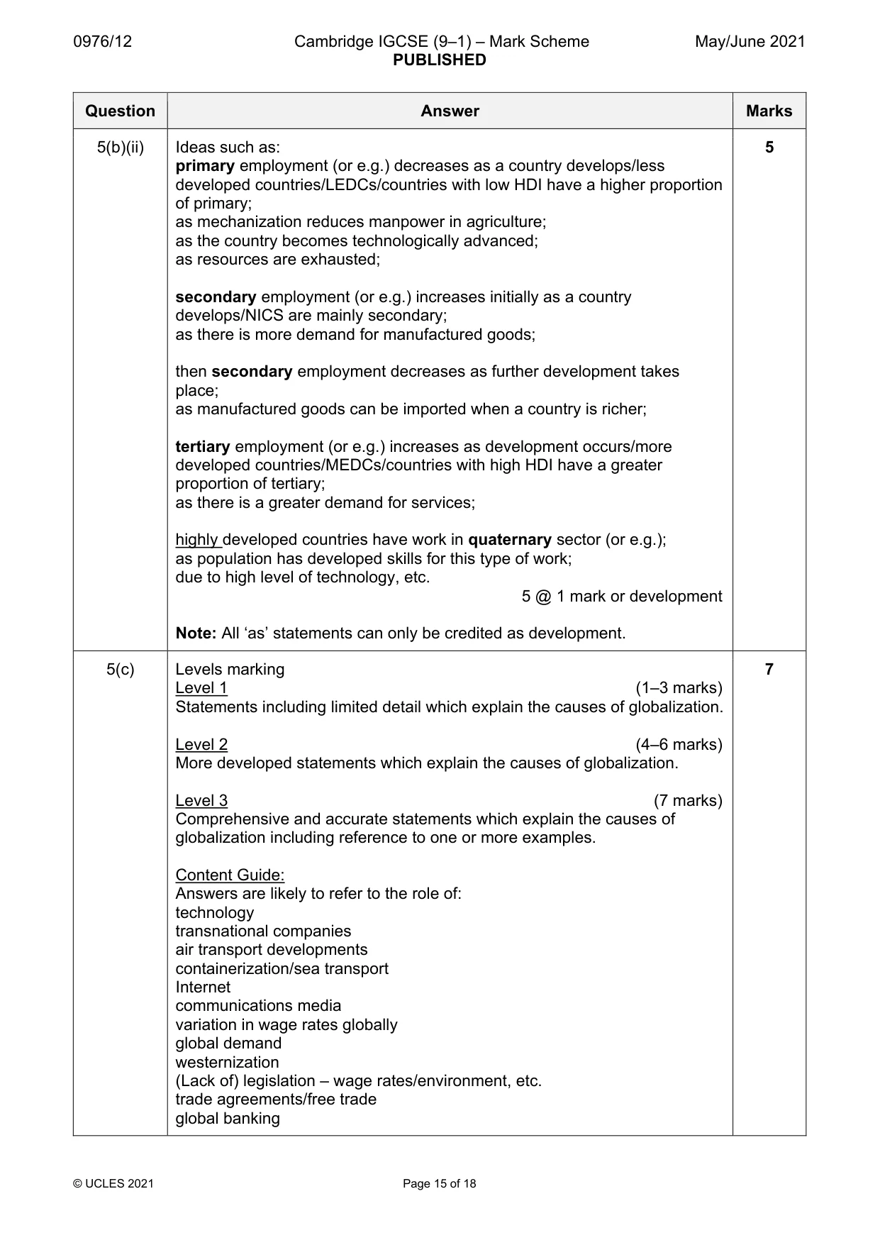
20 0976/12/M/J/21 © UCLES 2021 (b) Study Figs. 5.2, 5.3 and 5.4 (Insert), which are photographs showing different employment sectors. (i) Identify the employment sectors shown in each of Figs. 5.2, 5.3 and 5.4. Fig. 5.2 … Fig. 5.3 … Fig. 5.4 … [3] (ii) Explain why the employment structure of a country is a good indicator of its level of development. … … … … … … … … … … [5]
Question paper, page 21
21 0976/12/M/J/21 © UCLES 2021 [Turn over (c) Explain the causes of globalisation. You should refer to examples which you have studied. … … … … … … … … … … … … … … … … … … … … … … … … … … [7] [Total: 25]
Question paper, page 22
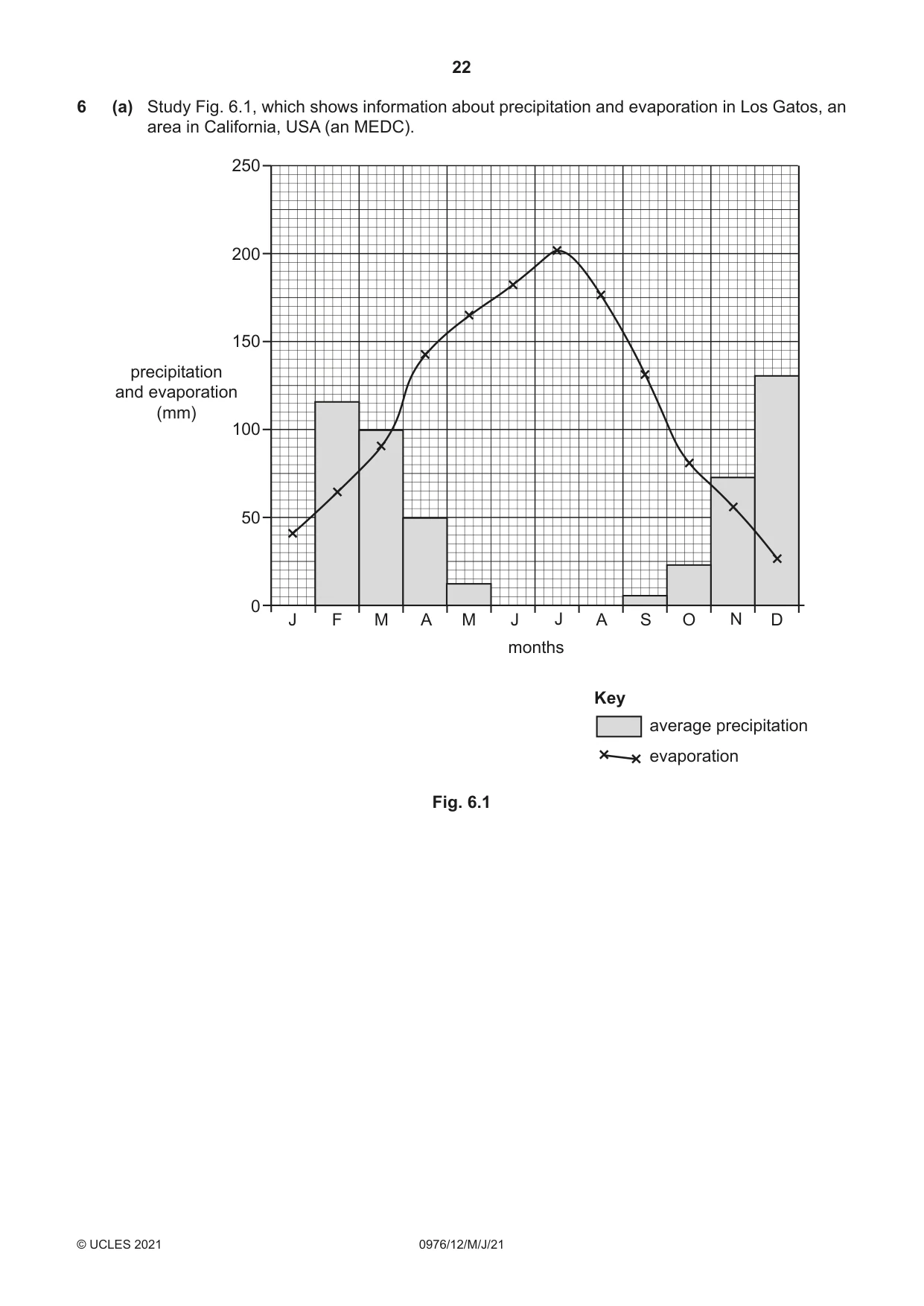
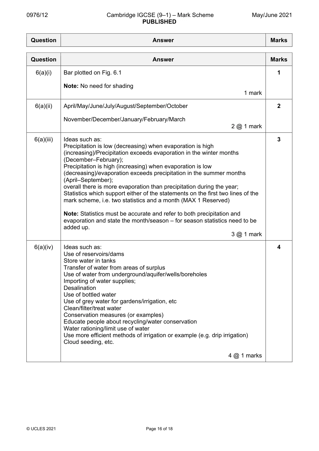
22 0976/12/M/J/21 © UCLES 2021 6 (a) Study Fig. 6.1, which shows information about precipitation and evaporation in Los Gatos, an area in California, USA (an MEDC). 0 50 100 150 200 250 J F M A M J J A S O N D months precipitation and evaporation (mm) Key average precipitation evaporation Fig. 6.1
Question paper, page 23
23 0976/12/M/J/21 © UCLES 2021 [Turn over (i) Complete Fig. 6.1 by plotting the following: The average precipitation in January is 130 mm. [1] (ii) Using Fig. 6.1 only, name: – a month when irrigation will be needed … – a month when soils may be waterlogged. … [2] (iii) Using Fig. 6.1 only, describe how the relationship between average precipitation and evaporation varies during the year. Use statistics to support your answer. … … … … … … [3] (iv) Suggest how water supply can be managed in areas such as California to ensure that it is available all year round. … … … … … … … … … [4]
Question paper, page 24
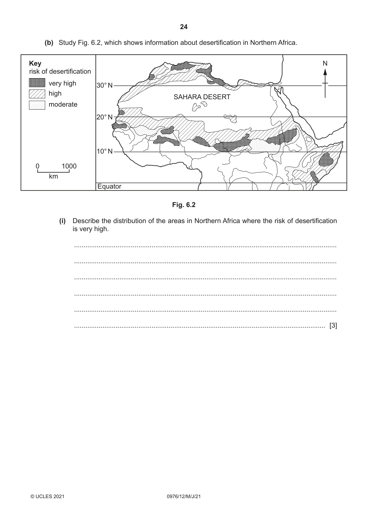
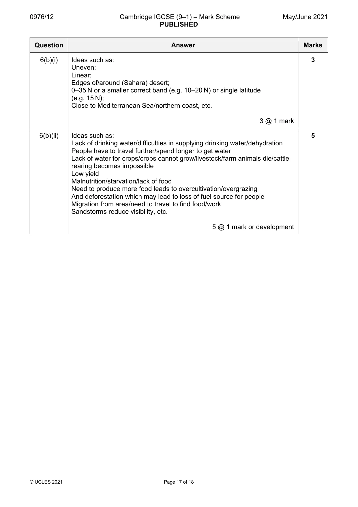
24 0976/12/M/J/21 © UCLES 2021 (b) Study Fig. 6.2, which shows information about desertification in Northern Africa. 0 1000 km Key very high risk of desertification high moderate 30° N 20° N 10° N Equator SAHARA DESERT N Fig. 6.2 (i) Describe the distribution of the areas in Northern Africa where the risk of desertification is very high. … … … … … … [3]
Question paper, page 25
25 0976/12/M/J/21 © UCLES 2021 [Turn over (ii) Describe the impacts of desertification on local people. … … … … … … … … … … [5]
Question paper, page 26
26 0976/12/M/J/21 © UCLES 2021 (c) For a named area you have studied, explain how economic activity is causing the local natural environment to be at risk. Name of area … Economic activity … … … … … … … … … … … … … … … … … … … … … … … … … [7] [Total: 25]
Question paper, page 27
27 0976/12/M/J/21 © UCLES 2021 Additional Pages If you use the following lined pages to complete the answer(s) to any question(s), the question number(s) must be clearly shown. … … … … … … … … … … … … … … … … … … … … … … … … … …
Question paper, page 28
28 0976/12/M/J/21 © UCLES 2021 … … … … … … … … … … … … … … … … … … … … … … … … … … … …
Question paper, page 29
29 0976/12/M/J/21 © UCLES 2021 BLANK PAGE
Question paper, page 30
30 0976/12/M/J/21 © UCLES 2021 BLANK PAGE
Question paper, page 31
31 0976/12/M/J/21 © UCLES 2021 BLANK PAGE
Question paper, page 32
32 0976/12/M/J/21 © UCLES 2021 BLANK PAGE The boundaries and names shown, the designations used and the presentation of material on any maps contained in this question paper/insert do not imply official endorsement or acceptance by Cambridge Assessment International Education concerning the legal status of any country, territory, or area or any of its authorities, or of the delimitation of its frontiers or boundaries. Permission to reproduce items where third-party owned material protected by copyright is included has been sought and cleared where possible. Every reasonable effort has been made by the publisher (UCLES) to trace copyright holders, but if any items requiring clearance have unwittingly been included, the publisher will be pleased to make amends at the earliest possible opportunity. To avoid the issue of disclosure of answer-related information to candidates, all copyright acknowledgements are reproduced online in the Cambridge Assessment International Education Copyright Acknowledgements Booklet. This is produced for each series of examinations and is freely available to download at www.cambridgeinternational.org after the live examination series. Cambridge Assessment International Education is part of the Cambridge Assessment Group. Cambridge Assessment is the brand name of the University of Cambridge Local Examinations Syndicate (UCLES), which itself is a department of the University of Cambridge.
Mark scheme, page 1
This document consists of 18 printed pages. © UCLES 2021 [Turn over Cambridge IGCSE™ (9–1) IGCSE GEOGRAPHY (9–1) 0976/12 Paper 1 May/June 2021 MARK SCHEME Maximum Mark: 75 Published This mark scheme is published as an aid to teachers and candidates, to indicate the requirements of the examination. It shows the basis on which Examiners were instructed to award marks. It does not indicate the details of the discussions that took place at an Examiners’ meeting before marking began, which would have considered the acceptability of alternative answers. Mark schemes should be read in conjunction with the question paper and the Principal Examiner Report for Teachers. Cambridge International will not enter into discussions about these mark schemes. Cambridge International is publishing the mark schemes for the May/June 2021 series for most Cambridge IGCSE™, Cambridge International A and AS Level components and some Cambridge O Level components.
Mark scheme, page 2
0976/12 Cambridge IGCSE (9–1) – Mark Scheme PUBLISHED May/June 2021 © UCLES 2021 Page 2 of 18 Generic Marking Principles These general marking principles must be applied by all examiners when marking candidate answers. They should be applied alongside the specific content of the mark scheme or generic level descriptors for a question. Each question paper and mark scheme will also comply with these marking principles. GENERIC MARKING PRINCIPLE 1: Marks must be awarded in line with: • the specific content of the mark scheme or the generic level descriptors for the question • the specific skills defined in the mark scheme or in the generic level descriptors for the question • the standard of response required by a candidate as exemplified by the standardisation scripts. GENERIC MARKING PRINCIPLE 2: Marks awarded are always whole marks (not half marks, or other fractions). GENERIC MARKING PRINCIPLE 3: Marks must be awarded positively: • marks are awarded for correct/valid answers, as defined in the mark scheme. However, credit is given for valid answers which go beyond the scope of the syllabus and mark scheme, referring to your Team Leader as appropriate • marks are awarded when candidates clearly demonstrate what they know and can do • marks are not deducted for errors • marks are not deducted for omissions • answers should only be judged on the quality of spelling, punctuation and grammar when these features are specifically assessed by the question as indicated by the mark scheme. The meaning, however, should be unambiguous. GENERIC MARKING PRINCIPLE 4: Rules must be applied consistently, e.g. in situations where candidates have not followed instructions or in the application of generic level descriptors. GENERIC MARKING PRINCIPLE 5: Marks should be awarded using the full range of marks defined in the mark scheme for the question (however; the use of the full mark range may be limited according to the quality of the candidate responses seen). GENERIC MARKING PRINCIPLE 6: Marks awarded are based solely on the requirements as defined in the mark scheme. Marks should not be awarded with grade thresholds or grade descriptors in mind.
Mark scheme, page 3
0976/12 Cambridge IGCSE (9–1) – Mark Scheme PUBLISHED May/June 2021 © UCLES 2021 Page 3 of 18 Each question carries 25 marks. Candidates cannot earn above the maximum marks available within each sub section. The marking scheme attempts to give guidance about the requirements of each answer and lists a number of responses, which will earn marks along with the general principles to be applied when marking each question. It should be noted that candidates can earn marks if their answers are phrased differently provided they convey the same meaning as those in the mark scheme. THE CANDIDATES DO NOT NEED TO USE THE SAME WORDING TO EARN MARKS. The notation `etc.` at the end of an answer in the mark scheme signifies that there may well be other correct responses or examples that can be given credit. Providing the statement is true, relevant to the question asked and not repetition of a previous point made credit should be given. A point made within one sub-section which is an answer to the question set in a different sub-section should not be given credit as each sub-section asks different questions which require independent answers. The mark scheme uses semi colons (;) to separate marks and diagonals to separate alternative answers. During coordination the mark scheme may need to be modified to add points agreed after discussion or to note any points not allowed. All examiners should ensure that their modified scheme is fully up- to-date before marking begins. Marking Mechanics Point marking is used for sections (a) and (b) of each question, although marks are available in specified questions for development of appropriate points. Ticks should be used to clearly indicate where a mark has been allowed. Where a development point has been allowed the symbol “DEV” should be placed adjacent to the tick. The number of ticks should always be equal to the total number of marks awarded. Only one development mark for each mark scheme point please. Where a candidate makes a point which is not quite sufficient for credit an upturned `V` insert symbol should be used. If after careful consideration a mark is awarded which gives `benefit of doubt` to the candidate the letter `J` should be placed adjacent to the tick (i.e. the candidate has `just` achieved the mark). Crosses are acceptable to signify wrong answers and the letters `I/R` should be used to indicate those which are irrelevant. Levels of response marking is used for section (c) of each question. Thus it is the quality of the response that determines which level an answer is achieved rather than the quantity of statements contained within it. However, once assigned to a level the mark achieved within that level is determined by the number of points made. Levels 1 and 2 are distinguished by whether statements are simple (level 1) or developed/elaborated (level 2). A candidate can immediately enter L2 by making developed points without making any L1 statements. In order to achieve L3 a candidate must have already reached the top end of L2 – in addition his/her answer should have a clear example and if the answer is place specific as well (7 marks). Highlight place specific detail.
Mark scheme, page 4
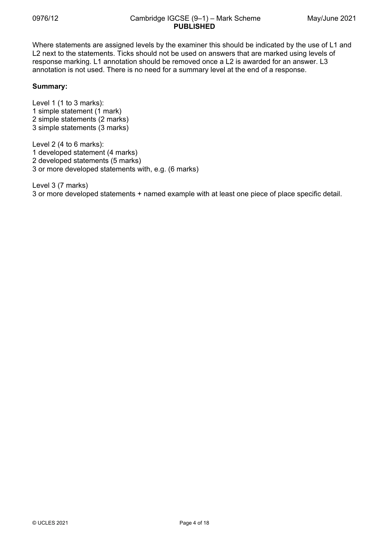
0976/12 Cambridge IGCSE (9–1) – Mark Scheme PUBLISHED May/June 2021 © UCLES 2021 Page 4 of 18 Where statements are assigned levels by the examiner this should be indicated by the use of L1 and L2 next to the statements. Ticks should not be used on answers that are marked using levels of response marking. L1 annotation should be removed once a L2 is awarded for an answer. L3 annotation is not used. There is no need for a summary level at the end of a response. Summary: Level 1 (1 to 3 marks): 1 simple statement (1 mark) 2 simple statements (2 marks) 3 simple statements (3 marks) Level 2 (4 to 6 marks): 1 developed statement (4 marks) 2 developed statements (5 marks) 3 or more developed statements with, e.g. (6 marks) Level 3 (7 marks) 3 or more developed statements + named example with at least one piece of place specific detail.
Mark scheme, page 5
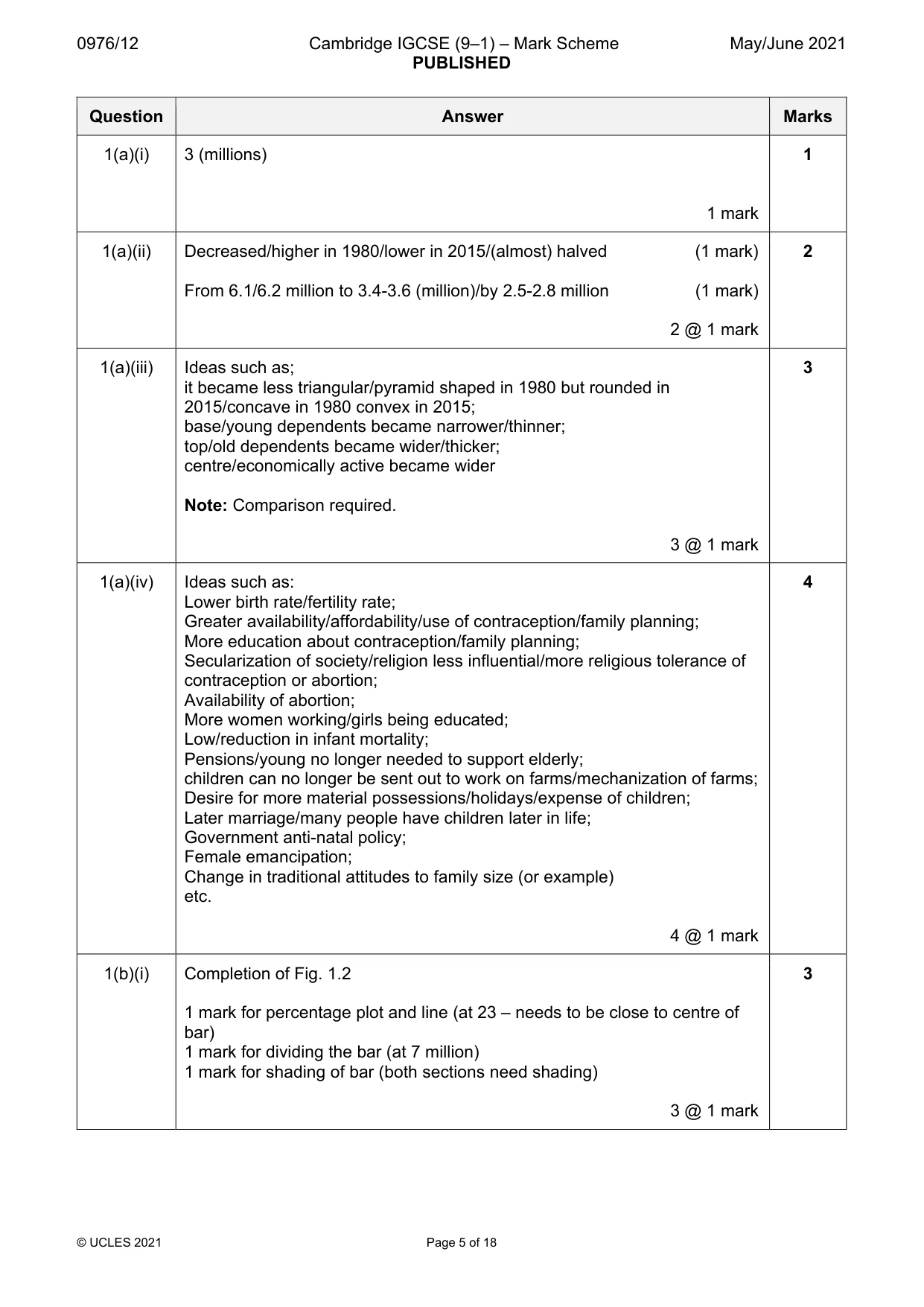
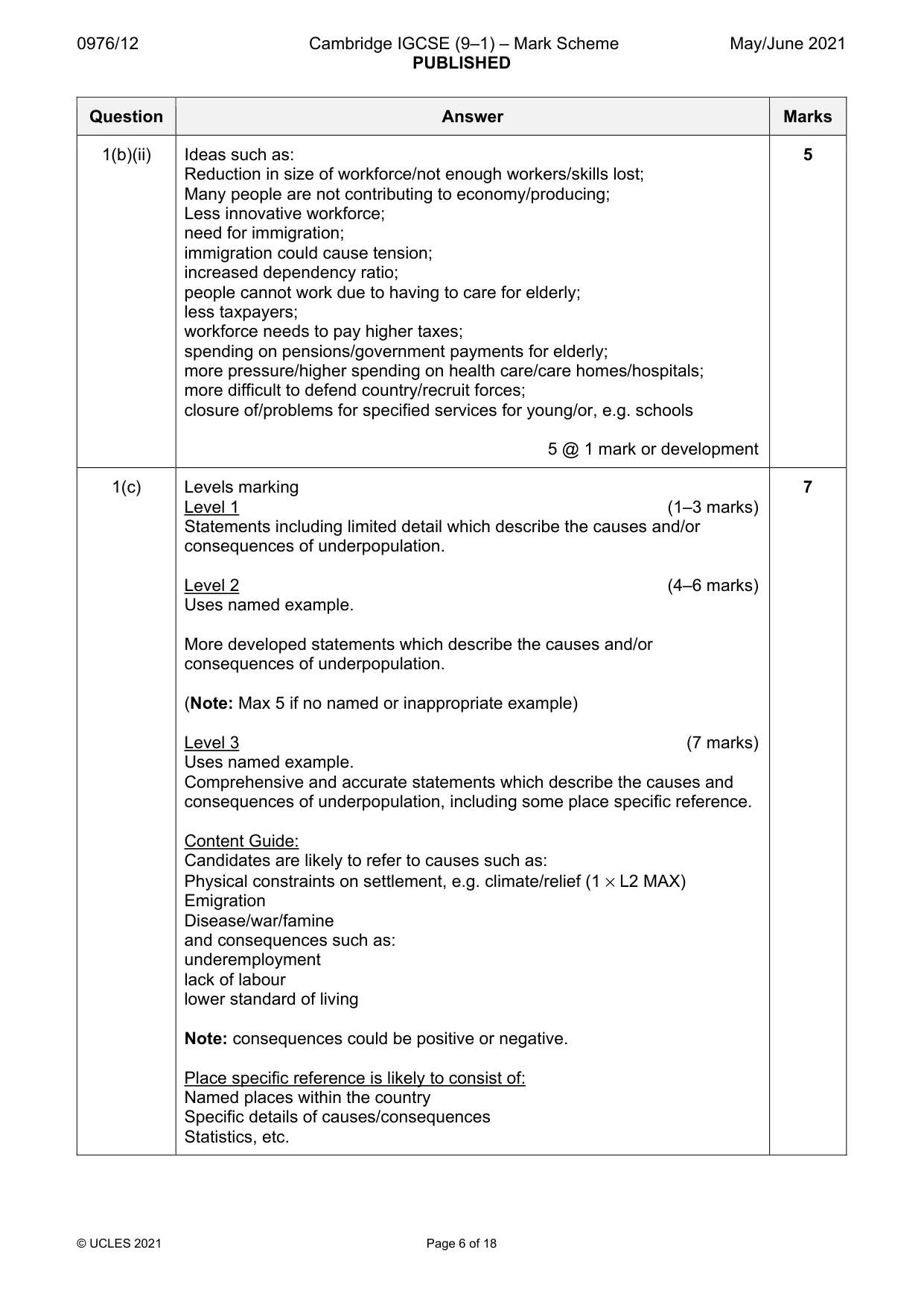
0976/12 Cambridge IGCSE (9–1) – Mark Scheme PUBLISHED May/June 2021 © UCLES 2021 Page 5 of 18 Question Answer Marks 1(a)(i) 3 (millions) 1 mark 1 1(a)(ii) Decreased/higher in 1980/lower in 2015/(almost) halved (1 mark) From 6.1/6.2 million to 3.4-3.6 (million)/by 2.5-2.8 million (1 mark) 2 @ 1 mark 2 1(a)(iii) Ideas such as; it became less triangular/pyramid shaped in 1980 but rounded in 2015/concave in 1980 convex in 2015; base/young dependents became narrower/thinner; top/old dependents became wider/thicker; centre/economically active became wider Note: Comparison required. 3 @ 1 mark 3 1(a)(iv) Ideas such as: Lower birth rate/fertility rate; Greater availability/affordability/use of contraception/family planning; More education about contraception/family planning; Secularization of society/religion less influential/more religious tolerance of contraception or abortion; Availability of abortion; More women working/girls being educated; Low/reduction in infant mortality; Pensions/young no longer needed to support elderly; children can no longer be sent out to work on farms/mechanization of farms; Desire for more material possessions/holidays/expense of children; Later marriage/many people have children later in life; Government anti-natal policy; Female emancipation; Change in traditional attitudes to family size (or example) etc. 4 @ 1 mark 4 1(b)(i) Completion of Fig. 1.2 1 mark for percentage plot and line (at 23 – needs to be close to centre of bar) 1 mark for dividing the bar (at 7 million) 1 mark for shading of bar (both sections need shading) 3 @ 1 mark 3
Mark scheme, page 6
0976/12 Cambridge IGCSE (9–1) – Mark Scheme PUBLISHED May/June 2021 © UCLES 2021 Page 6 of 18 Question Answer Marks 1(b)(ii) Ideas such as: Reduction in size of workforce/not enough workers/skills lost; Many people are not contributing to economy/producing; Less innovative workforce; need for immigration; immigration could cause tension; increased dependency ratio; people cannot work due to having to care for elderly; less taxpayers; workforce needs to pay higher taxes; spending on pensions/government payments for elderly; more pressure/higher spending on health care/care homes/hospitals; more difficult to defend country/recruit forces; closure of/problems for specified services for young/or, e.g. schools 5 @ 1 mark or development 5 1(c) Levels marking Level 1 (1–3 marks) Statements including limited detail which describe the causes and/or consequences of underpopulation. Level 2 (4–6 marks) Uses named example. More developed statements which describe the causes and/or consequences of underpopulation. (Note: Max 5 if no named or inappropriate example) Level 3 (7 marks) Uses named example. Comprehensive and accurate statements which describe the causes and consequences of underpopulation, including some place specific reference. Content Guide: Candidates are likely to refer to causes such as: Physical constraints on settlement, e.g. climate/relief (1 × L2 MAX) Emigration Disease/war/famine and consequences such as: underemployment lack of labour lower standard of living Note: consequences could be positive or negative. Place specific reference is likely to consist of: Named places within the country Specific details of causes/consequences Statistics, etc. 7
Mark scheme, page 7
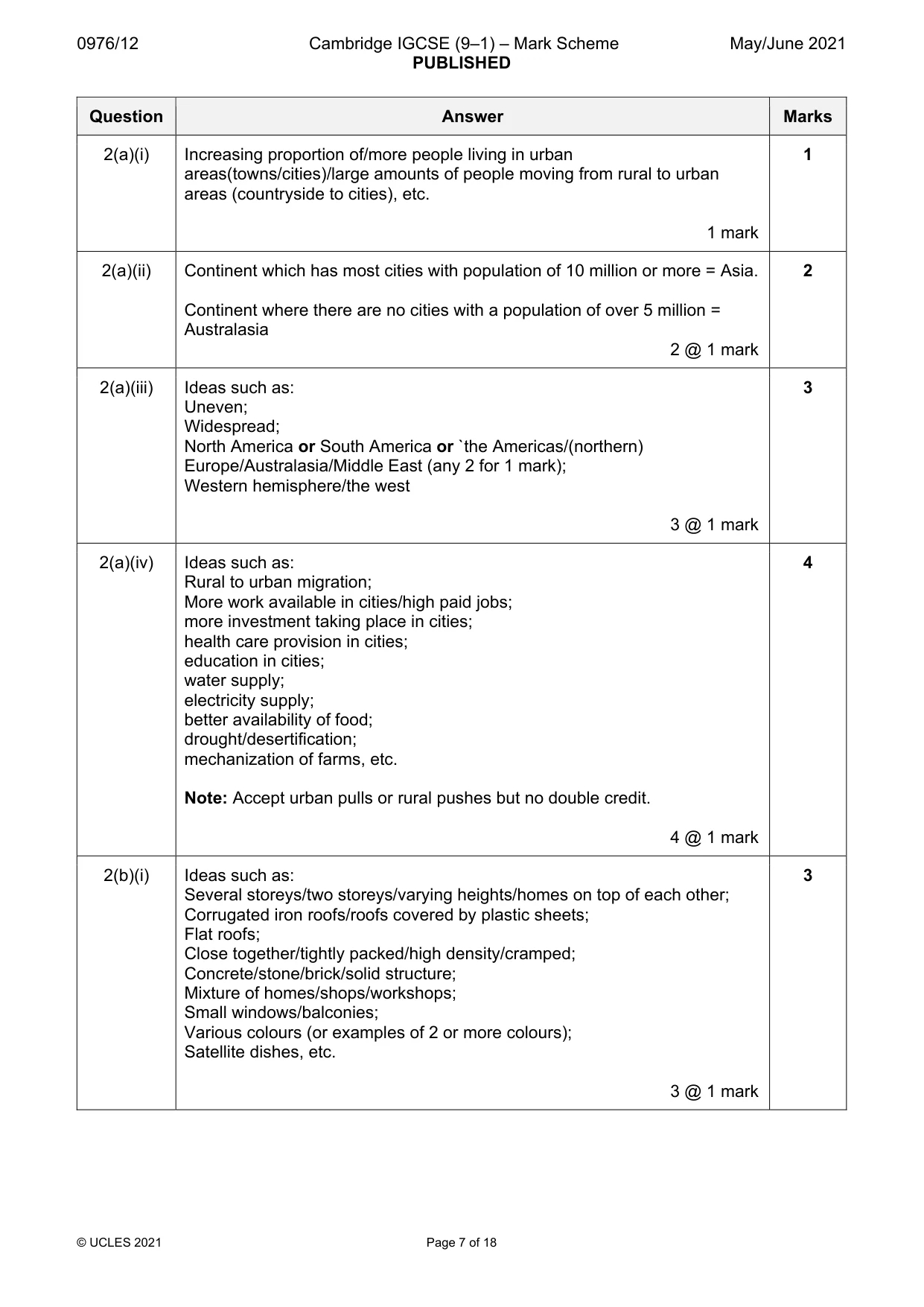
0976/12 Cambridge IGCSE (9–1) – Mark Scheme PUBLISHED May/June 2021 © UCLES 2021 Page 7 of 18 Question Answer Marks 2(a)(i) Increasing proportion of/more people living in urban areas(towns/cities)/large amounts of people moving from rural to urban areas (countryside to cities), etc. 1 mark 1 2(a)(ii) Continent which has most cities with population of 10 million or more = Asia. Continent where there are no cities with a population of over 5 million = Australasia 2 @ 1 mark 2 2(a)(iii) Ideas such as: Uneven; Widespread; North America or South America or `the Americas/(northern) Europe/Australasia/Middle East (any 2 for 1 mark); Western hemisphere/the west 3 @ 1 mark 3 2(a)(iv) Ideas such as: Rural to urban migration; More work available in cities/high paid jobs; more investment taking place in cities; health care provision in cities; education in cities; water supply; electricity supply; better availability of food; drought/desertification; mechanization of farms, etc. Note: Accept urban pulls or rural pushes but no double credit. 4 @ 1 mark 4 2(b)(i) Ideas such as: Several storeys/two storeys/varying heights/homes on top of each other; Corrugated iron roofs/roofs covered by plastic sheets; Flat roofs; Close together/tightly packed/high density/cramped; Concrete/stone/brick/solid structure; Mixture of homes/shops/workshops; Small windows/balconies; Various colours (or examples of 2 or more colours); Satellite dishes, etc. 3 @ 1 mark 3
Mark scheme, page 8
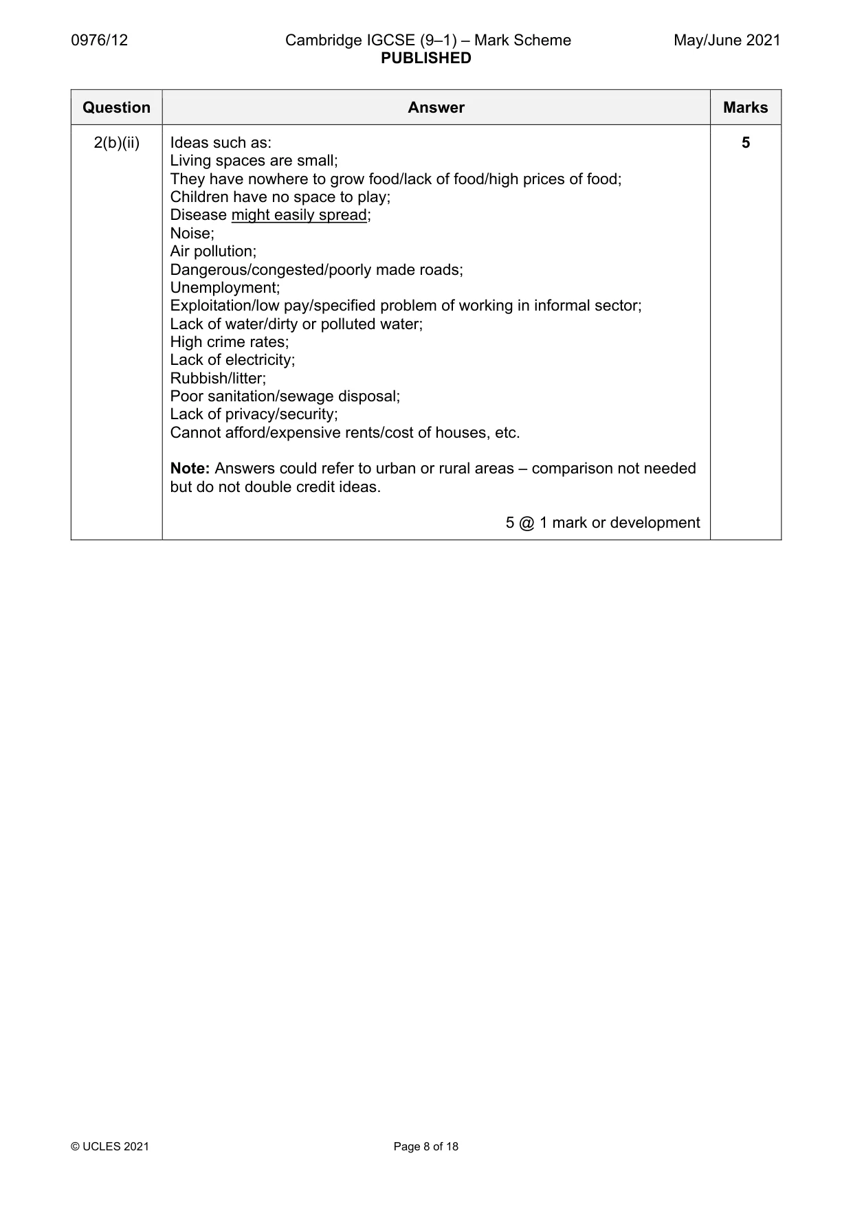
0976/12 Cambridge IGCSE (9–1) – Mark Scheme PUBLISHED May/June 2021 © UCLES 2021 Page 8 of 18 Question Answer Marks 2(b)(ii) Ideas such as: Living spaces are small; They have nowhere to grow food/lack of food/high prices of food; Children have no space to play; Disease might easily spread; Noise; Air pollution; Dangerous/congested/poorly made roads; Unemployment; Exploitation/low pay/specified problem of working in informal sector; Lack of water/dirty or polluted water; High crime rates; Lack of electricity; Rubbish/litter; Poor sanitation/sewage disposal; Lack of privacy/security; Cannot afford/expensive rents/cost of houses, etc. Note: Answers could refer to urban or rural areas – comparison not needed but do not double credit ideas. 5 @ 1 mark or development 5
Mark scheme, page 9
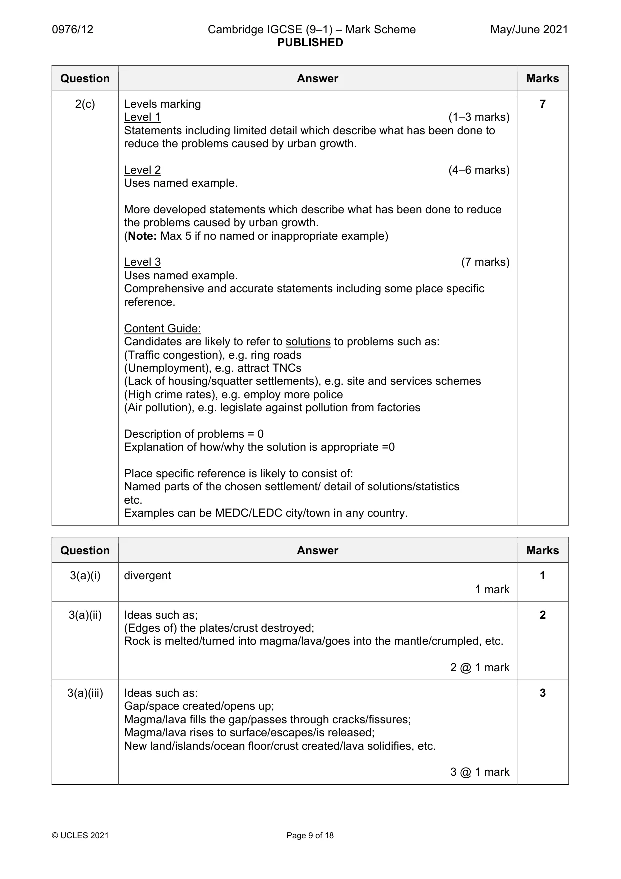
0976/12 Cambridge IGCSE (9–1) – Mark Scheme PUBLISHED May/June 2021 © UCLES 2021 Page 9 of 18 Question Answer Marks 2(c) Levels marking Level 1 (1–3 marks) Statements including limited detail which describe what has been done to reduce the problems caused by urban growth. Level 2 (4–6 marks) Uses named example. More developed statements which describe what has been done to reduce the problems caused by urban growth. (Note: Max 5 if no named or inappropriate example) Level 3 (7 marks) Uses named example. Comprehensive and accurate statements including some place specific reference. Content Guide: Candidates are likely to refer to solutions to problems such as: (Traffic congestion), e.g. ring roads (Unemployment), e.g. attract TNCs (Lack of housing/squatter settlements), e.g. site and services schemes (High crime rates), e.g. employ more police (Air pollution), e.g. legislate against pollution from factories Description of problems = 0 Explanation of how/why the solution is appropriate =0 Place specific reference is likely to consist of: Named parts of the chosen settlement/ detail of solutions/statistics etc. Examples can be MEDC/LEDC city/town in any country. 7 Question Answer Marks 3(a)(i) divergent 1 mark 1 3(a)(ii) Ideas such as; (Edges of) the plates/crust destroyed; Rock is melted/turned into magma/lava/goes into the mantle/crumpled, etc. 2 @ 1 mark 2 3(a)(iii) Ideas such as: Gap/space created/opens up; Magma/lava fills the gap/passes through cracks/fissures; Magma/lava rises to surface/escapes/is released; New land/islands/ocean floor/crust created/lava solidifies, etc. 3 @ 1 mark 3
Mark scheme, page 10
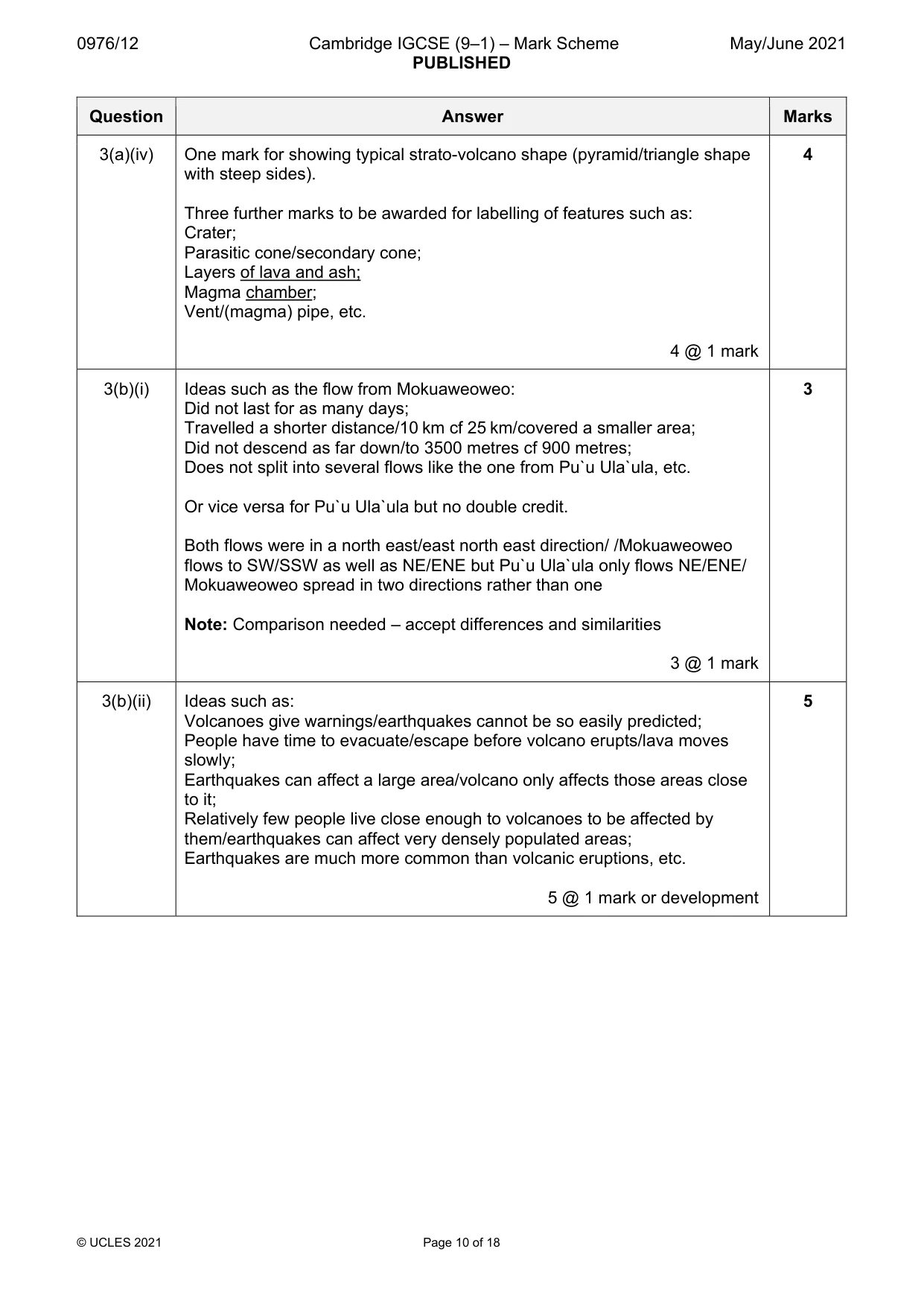
0976/12 Cambridge IGCSE (9–1) – Mark Scheme PUBLISHED May/June 2021 © UCLES 2021 Page 10 of 18 Question Answer Marks 3(a)(iv) One mark for showing typical strato-volcano shape (pyramid/triangle shape with steep sides). Three further marks to be awarded for labelling of features such as: Crater; Parasitic cone/secondary cone; Layers of lava and ash; Magma chamber; Vent/(magma) pipe, etc. 4 @ 1 mark 4 3(b)(i) Ideas such as the flow from Mokuaweoweo: Did not last for as many days; Travelled a shorter distance/10 km cf 25 km/covered a smaller area; Did not descend as far down/to 3500 metres cf 900 metres; Does not split into several flows like the one from Pu`u Ula`ula, etc. Or vice versa for Pu`u Ula`ula but no double credit. Both flows were in a north east/east north east direction/ /Mokuaweoweo flows to SW/SSW as well as NE/ENE but Pu`u Ula`ula only flows NE/ENE/ Mokuaweoweo spread in two directions rather than one Note: Comparison needed – accept differences and similarities 3 @ 1 mark 3 3(b)(ii) Ideas such as: Volcanoes give warnings/earthquakes cannot be so easily predicted; People have time to evacuate/escape before volcano erupts/lava moves slowly; Earthquakes can affect a large area/volcano only affects those areas close to it; Relatively few people live close enough to volcanoes to be affected by them/earthquakes can affect very densely populated areas; Earthquakes are much more common than volcanic eruptions, etc. 5 @ 1 mark or development 5
Mark scheme, page 11
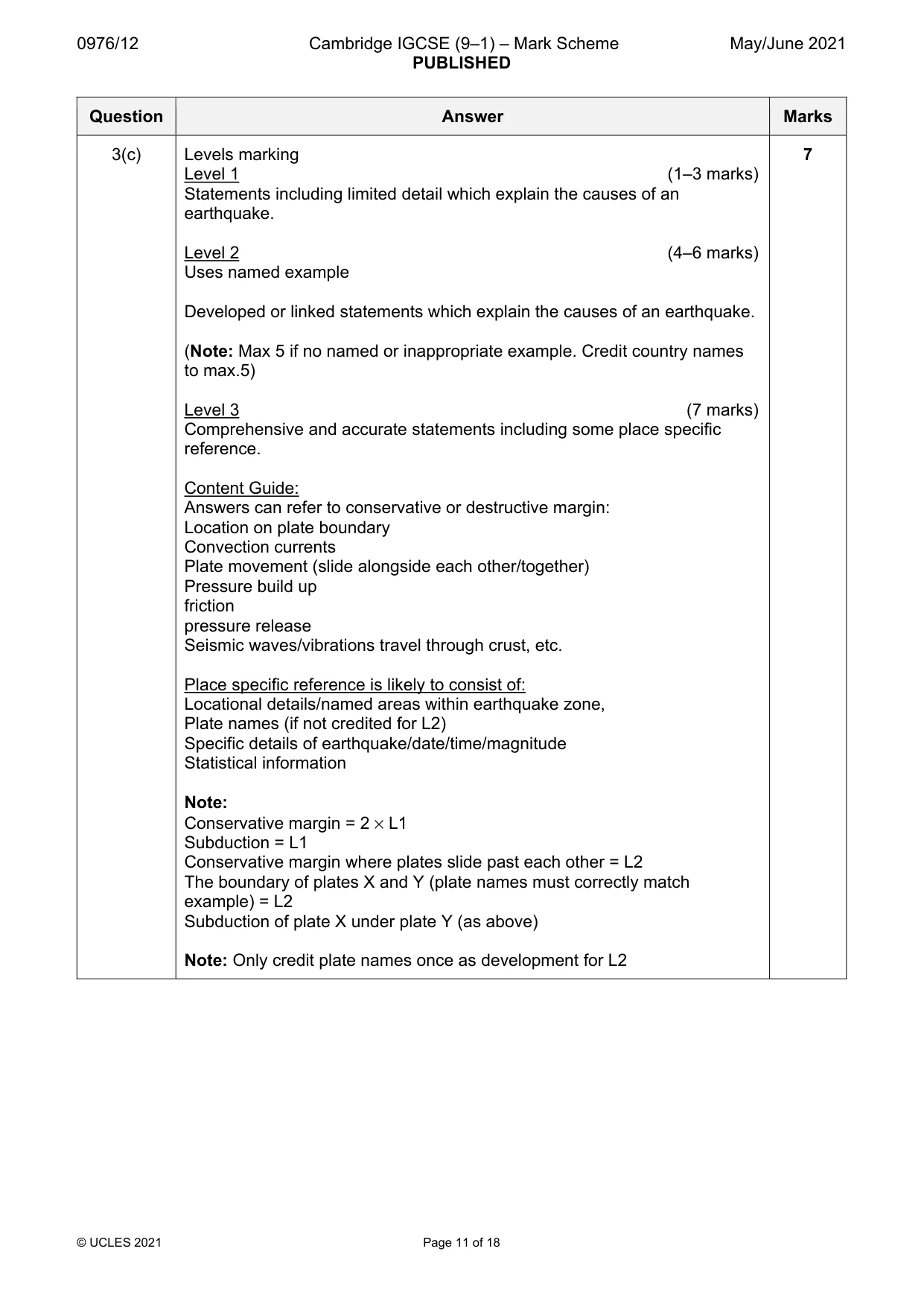
0976/12 Cambridge IGCSE (9–1) – Mark Scheme PUBLISHED May/June 2021 © UCLES 2021 Page 11 of 18 Question Answer Marks 3(c) Levels marking Level 1 (1–3 marks) Statements including limited detail which explain the causes of an earthquake. Level 2 (4–6 marks) Uses named example Developed or linked statements which explain the causes of an earthquake. (Note: Max 5 if no named or inappropriate example. Credit country names to max.5) Level 3 (7 marks) Comprehensive and accurate statements including some place specific reference. Content Guide: Answers can refer to conservative or destructive margin: Location on plate boundary Convection currents Plate movement (slide alongside each other/together) Pressure build up friction pressure release Seismic waves/vibrations travel through crust, etc. Place specific reference is likely to consist of: Locational details/named areas within earthquake zone, Plate names (if not credited for L2) Specific details of earthquake/date/time/magnitude Statistical information Note: Conservative margin = 2 × L1 Subduction = L1 Conservative margin where plates slide past each other = L2 The boundary of plates X and Y (plate names must correctly match example) = L2 Subduction of plate X under plate Y (as above) Note: Only credit plate names once as development for L2 7
Mark scheme, page 12
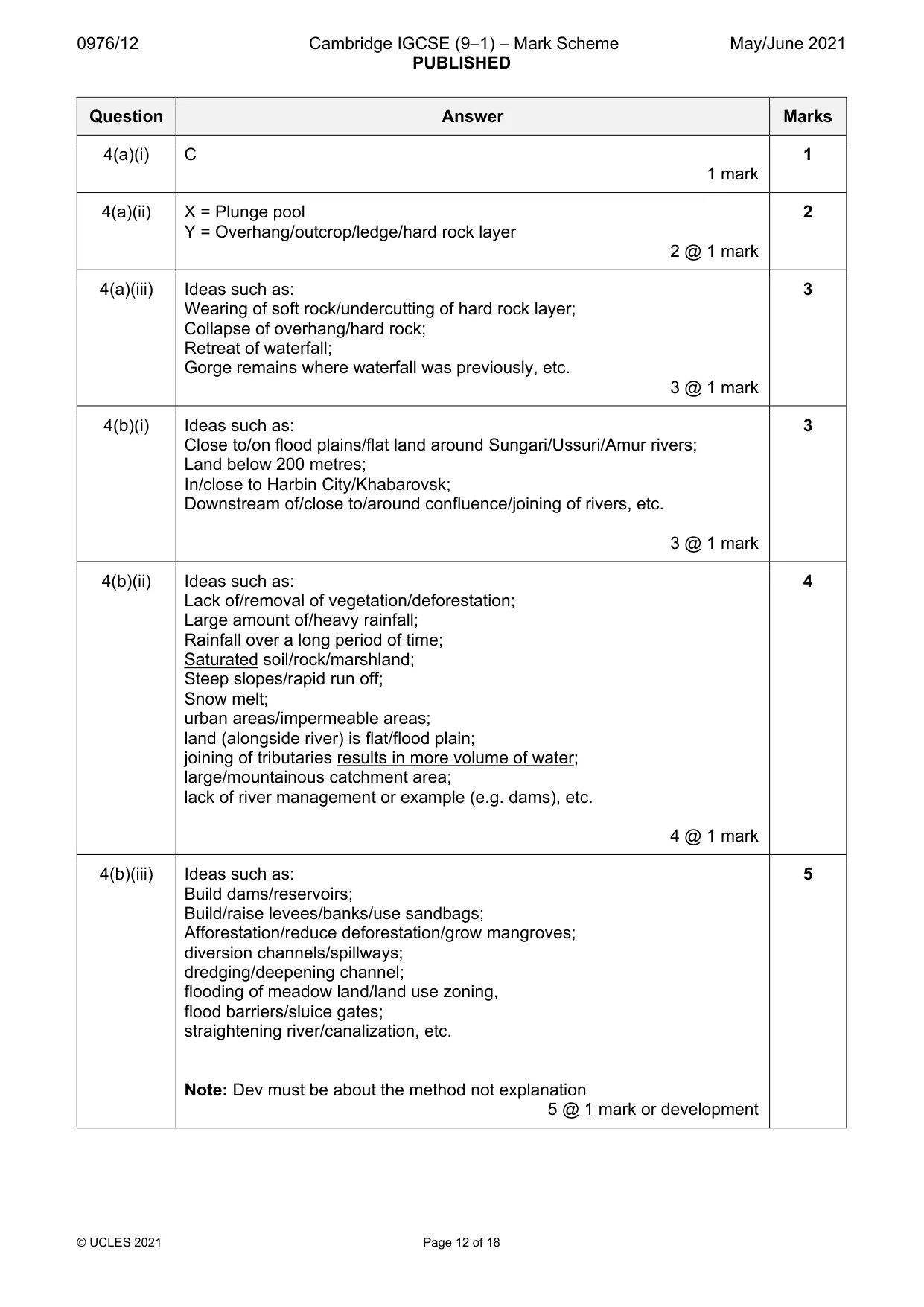
0976/12 Cambridge IGCSE (9–1) – Mark Scheme PUBLISHED May/June 2021 © UCLES 2021 Page 12 of 18 Question Answer Marks 4(a)(i) C 1 mark 1 4(a)(ii) X = Plunge pool Y = Overhang/outcrop/ledge/hard rock layer 2 @ 1 mark 2 4(a)(iii) Ideas such as: Wearing of soft rock/undercutting of hard rock layer; Collapse of overhang/hard rock; Retreat of waterfall; Gorge remains where waterfall was previously, etc. 3 @ 1 mark 3 4(b)(i) Ideas such as: Close to/on flood plains/flat land around Sungari/Ussuri/Amur rivers; Land below 200 metres; In/close to Harbin City/Khabarovsk; Downstream of/close to/around confluence/joining of rivers, etc. 3 @ 1 mark 3 4(b)(ii) Ideas such as: Lack of/removal of vegetation/deforestation; Large amount of/heavy rainfall; Rainfall over a long period of time; Saturated soil/rock/marshland; Steep slopes/rapid run off; Snow melt; urban areas/impermeable areas; land (alongside river) is flat/flood plain; joining of tributaries results in more volume of water; large/mountainous catchment area; lack of river management or example (e.g. dams), etc. 4 @ 1 mark 4 4(b)(iii) Ideas such as: Build dams/reservoirs; Build/raise levees/banks/use sandbags; Afforestation/reduce deforestation/grow mangroves; diversion channels/spillways; dredging/deepening channel; flooding of meadow land/land use zoning, flood barriers/sluice gates; straightening river/canalization, etc. Note: Dev must be about the method not explanation 5 @ 1 mark or development 5
Mark scheme, page 13
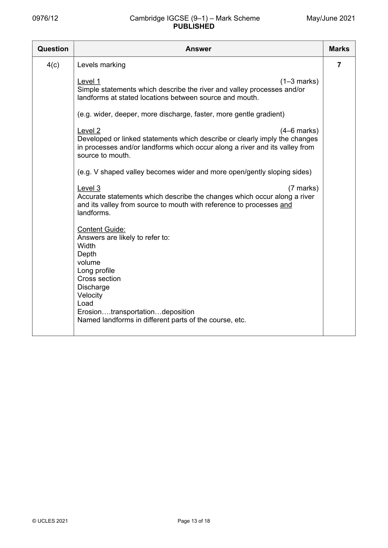
0976/12 Cambridge IGCSE (9–1) – Mark Scheme PUBLISHED May/June 2021 © UCLES 2021 Page 13 of 18 Question Answer Marks 4(c) Levels marking Level 1 (1–3 marks) Simple statements which describe the river and valley processes and/or landforms at stated locations between source and mouth. (e.g. wider, deeper, more discharge, faster, more gentle gradient) Level 2 (4–6 marks) Developed or linked statements which describe or clearly imply the changes in processes and/or landforms which occur along a river and its valley from source to mouth. (e.g. V shaped valley becomes wider and more open/gently sloping sides) Level 3 (7 marks) Accurate statements which describe the changes which occur along a river and its valley from source to mouth with reference to processes and landforms. Content Guide: Answers are likely to refer to: Width Depth volume Long profile Cross section Discharge Velocity Load Erosion….transportation…deposition Named landforms in different parts of the course, etc. 7
Mark scheme, page 14
0976/12 Cambridge IGCSE (9–1) – Mark Scheme PUBLISHED May/June 2021 © UCLES 2021 Page 14 of 18 Question Answer Marks 5(a)(i) Human Development Index (all three words need to be correct) 1 mark 1 5(a)(ii) Ogun….Kwara….Borno…Sokoto All correct = 2 marks 2/3 correct = 1 mark 0/1 correct = 0 marks 2 @ 1 mark 2 5(a)(iii) Ideas such as: high income/GDP; High life expectancy/good health care/clinics/hospitals/many doctors/nurses/vaccination/medicines are available in some states; good education/skills/literacy; Presence/absence of mineral/natural resources or example; Energy supplies or example; Whether the state is mainly rural or urban; Availability of water supplies/drought/presence of rivers; Mainly primary sector/agriculture low income; Development of manufacturing/secondary industry/TNCs increase wealth; Development of business/commerce/tertiary employment increase wealth; Development of tourism; good accessibility/roads/railways/transport; Historical development/impact of colonialism; Fertility of soils/efficiency of agriculture; Impacts of trade/exports; Government/corruption/variation in government funding; Whether state is landlocked or coastal; Civil war/conflict, etc. 3 @ 1 mark 3 5(a)(iv) Ideas such as: HDI is a composite indicator of development/HDI looks at social factors (as well as economic factors); education/literacy and health/life expectancy); HDI scores for every country are between 0 and 1/based on comparable measurements; HDI is not affected by population size unlike total GNP. HDI can be used to show changes over time/it is not affected by inflation, etc. Note: No need for comparison 4 @ 1 mark 4 5(b)(i) Fig. 5.2 = Secondary/quaternary Fig. 5.3 = Primary Fig. 5.4 = Tertiary 3 @ 1 mark 3
Mark scheme, page 15
0976/12 Cambridge IGCSE (9–1) – Mark Scheme PUBLISHED May/June 2021 © UCLES 2021 Page 15 of 18 Question Answer Marks 5(b)(ii) Ideas such as: primary employment (or e.g.) decreases as a country develops/less developed countries/LEDCs/countries with low HDI have a higher proportion of primary; as mechanization reduces manpower in agriculture; as the country becomes technologically advanced; as resources are exhausted; secondary employment (or e.g.) increases initially as a country develops/NICS are mainly secondary; as there is more demand for manufactured goods; then secondary employment decreases as further development takes place; as manufactured goods can be imported when a country is richer; tertiary employment (or e.g.) increases as development occurs/more developed countries/MEDCs/countries with high HDI have a greater proportion of tertiary; as there is a greater demand for services; highly developed countries have work in quaternary sector (or e.g.); as population has developed skills for this type of work; due to high level of technology, etc. 5 @ 1 mark or development Note: All ‘as’ statements can only be credited as development. 5 5(c) Levels marking Level 1 (1–3 marks) Statements including limited detail which explain the causes of globalization. Level 2 (4–6 marks) More developed statements which explain the causes of globalization. Level 3 (7 marks) Comprehensive and accurate statements which explain the causes of globalization including reference to one or more examples. Content Guide: Answers are likely to refer to the role of: technology transnational companies air transport developments containerization/sea transport Internet communications media variation in wage rates globally global demand westernization (Lack of) legislation – wage rates/environment, etc. trade agreements/free trade global banking 7
Mark scheme, page 16
0976/12 Cambridge IGCSE (9–1) – Mark Scheme PUBLISHED May/June 2021 © UCLES 2021 Page 16 of 18 Question Answer Marks Question Answer Marks 6(a)(i) Bar plotted on Fig. 6.1 Note: No need for shading 1 mark 1 6(a)(ii) April/May/June/July/August/September/October November/December/January/February/March 2 @ 1 mark 2 6(a)(iii) Ideas such as: Precipitation is low (decreasing) when evaporation is high (increasing)/Precipitation exceeds evaporation in the winter months (December–February); Precipitation is high (increasing) when evaporation is low (decreasing)/evaporation exceeds precipitation in the summer months (April–September); overall there is more evaporation than precipitation during the year; Statistics which support either of the statements on the first two lines of the mark scheme, i.e. two statistics and a month (MAX 1 Reserved) Note: Statistics must be accurate and refer to both precipitation and evaporation and state the month/season – for season statistics need to be added up. 3 @ 1 mark 3 6(a)(iv) Ideas such as: Use of reservoirs/dams Store water in tanks Transfer of water from areas of surplus Use of water from underground/aquifer/wells/boreholes Importing of water supplies; Desalination Use of bottled water Use of grey water for gardens/irrigation, etc Clean/filter/treat water Conservation measures (or examples) Educate people about recycling/water conservation Water rationing/limit use of water Use more efficient methods of irrigation or example (e.g. drip irrigation) Cloud seeding, etc. 4 @ 1 marks 4
Mark scheme, page 17
0976/12 Cambridge IGCSE (9–1) – Mark Scheme PUBLISHED May/June 2021 © UCLES 2021 Page 17 of 18 Question Answer Marks 6(b)(i) Ideas such as: Uneven; Linear; Edges of/around (Sahara) desert; 0–35 N or a smaller correct band (e.g. 10–20 N) or single latitude (e.g. 15 N); Close to Mediterranean Sea/northern coast, etc. 3 @ 1 mark 3 6(b)(ii) Ideas such as: Lack of drinking water/difficulties in supplying drinking water/dehydration People have to travel further/spend longer to get water Lack of water for crops/crops cannot grow/livestock/farm animals die/cattle rearing becomes impossible Low yield Malnutrition/starvation/lack of food Need to produce more food leads to overcultivation/overgrazing And deforestation which may lead to loss of fuel source for people Migration from area/need to travel to find food/work Sandstorms reduce visibility, etc. 5 @ 1 mark or development 5
Mark scheme, page 18
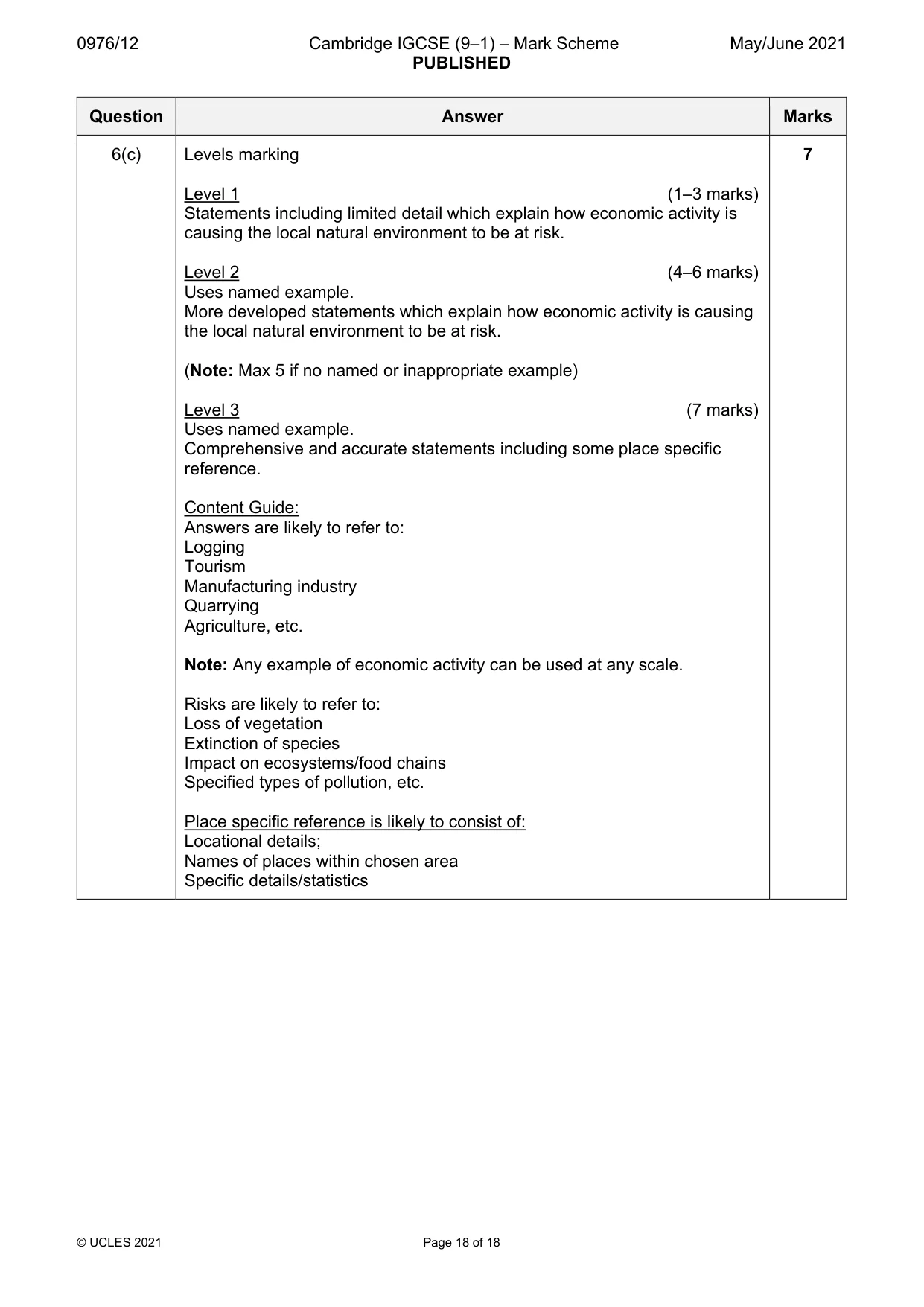
0976/12 Cambridge IGCSE (9–1) – Mark Scheme PUBLISHED May/June 2021 © UCLES 2021 Page 18 of 18 Question Answer Marks 6(c) Levels marking Level 1 (1–3 marks) Statements including limited detail which explain how economic activity is causing the local natural environment to be at risk. Level 2 (4–6 marks) Uses named example. More developed statements which explain how economic activity is causing the local natural environment to be at risk. (Note: Max 5 if no named or inappropriate example) Level 3 (7 marks) Uses named example. Comprehensive and accurate statements including some place specific reference. Content Guide: Answers are likely to refer to: Logging Tourism Manufacturing industry Quarrying Agriculture, etc. Note: Any example of economic activity can be used at any scale. Risks are likely to refer to: Loss of vegetation Extinction of species Impact on ecosystems/food chains Specified types of pollution, etc. Place specific reference is likely to consist of: Locational details; Names of places within chosen area Specific details/statistics 7
What you needed in this session
Cambridge’s own grade thresholds for 2021 May/June, Paper 1 · Variant 2. A higher threshold means an easier paper — the bar moves with how the cohort did.