Cambridge IGCSE Geography (9-1) 0976 — 2020 May/June Paper 1 · Variant 2
0976/12/M/J/20
The question paper and its mark scheme, free to read here and free to download. This is Cambridge’s own paper, exactly as it was sat.
Question paper28 pages











Mark scheme15 pages
Answers below. Sit the paper first if you are practising.
Paper as text
Question paper, page 1
* 9 7 7 5 3 8 8 2 9 7 * Cambridge IGCSE™ (9–1) DC (CJ/CB) 197556 © UCLES 2020 [Turn over This document has 28 pages. Blank pages are indicated. GEOGRAPHY 0976/12 Paper 1 Geographical Themes May/June 2020 1 hour 45 minutes You must answer on the question paper. You will need: Insert (enclosed) Calculator Ruler INSTRUCTIONS ● Answer three questions in total, one from each section. ● Use a black or dark blue pen. You may use an HB pencil for any diagrams or graphs. ● Write your name, centre number and candidate number in the boxes at the top of the page. ● Write your answer to each question in the space provided. ● Do not use an erasable pen or correction fluid. ● Do not write on any bar codes. ● If additional space is needed, you should use the lined pages at the end of this booklet; the question number or numbers must be clearly shown. INFORMATION ● The total mark for this paper is 75. ● The number of marks for each question or part question is shown in brackets [ ]. ● The insert contains additional resources referred to in the questions. Definitions MEDCs – More Economically Developed Countries LEDCs – Less Economically Developed Countries
Question paper, page 2
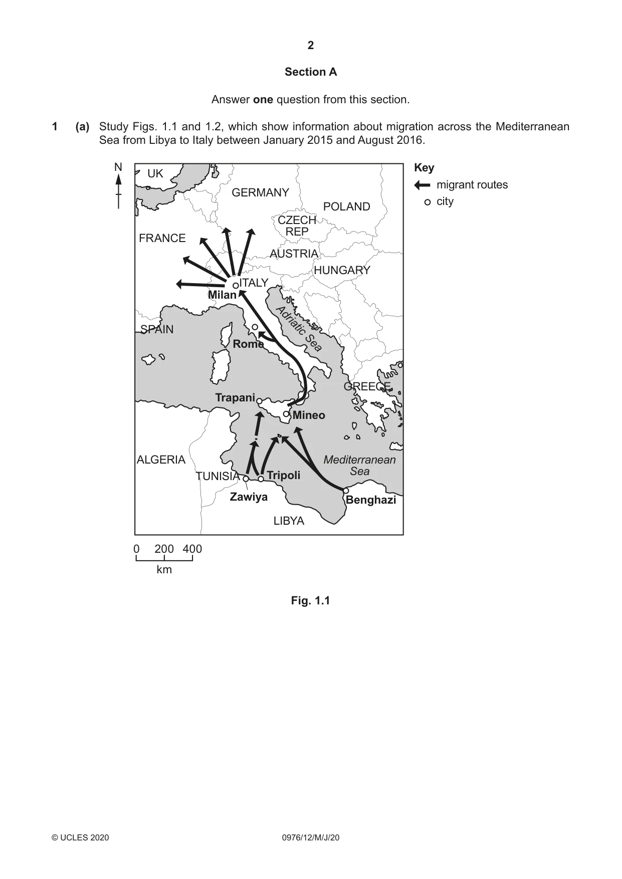
2 0976/12/M/J/20 © UCLES 2020 Section A Answer one question from this section. 1 (a) Study Figs. 1.1 and 1.2, which show information about migration across the Mediterranean Sea from Libya to Italy between January 2015 and August 2016. FRANCE GERMANY UK CZECH REP POLAND HUNGARY AUSTRIA ITALY GREECE TUNISIA ALGERIA SPAIN LIBYA Mediterranean Sea Adriatic Sea Tripoli Benghazi Zawiya Trapani Rome Milan Mineo Key migrant routes city N 0 200 400 km Fig. 1.1
Question paper, page 3
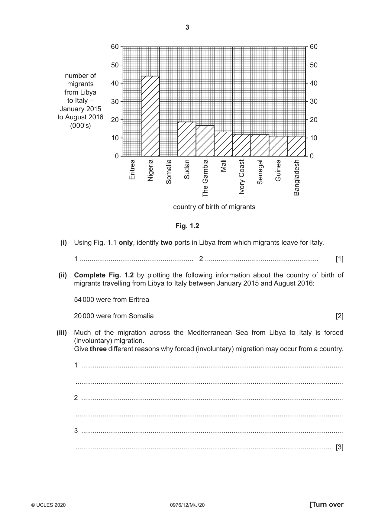
3 0976/12/M/J/20 © UCLES 2020 [Turn over number of migrants from Libya to Italy – January 2015 to August 2016 (000’s) 60 50 40 30 20 10 60 50 40 30 20 Eritrea Nigeria Somalia Sudan The Gambia Mali Ivory Coast Senegal Guinea country of birth of migrants Bangladesh 10 0 0 Fig. 1.2 (i) Using Fig. 1.1 only, identify two ports in Libya from which migrants leave for Italy. 1 … 2 … [1] (ii) Complete Fig. 1.2 by plotting the following information about the country of birth of migrants travelling from Libya to Italy between January 2015 and August 2016: 54 000 were from Eritrea 20 000 were from Somalia [2] (iii) Much of the migration across the Mediterranean Sea from Libya to Italy is forced (involuntary) migration. Give three different reasons why forced (involuntary) migration may occur from a country. 1 … … 2 … … 3 … … [3]
Question paper, page 4
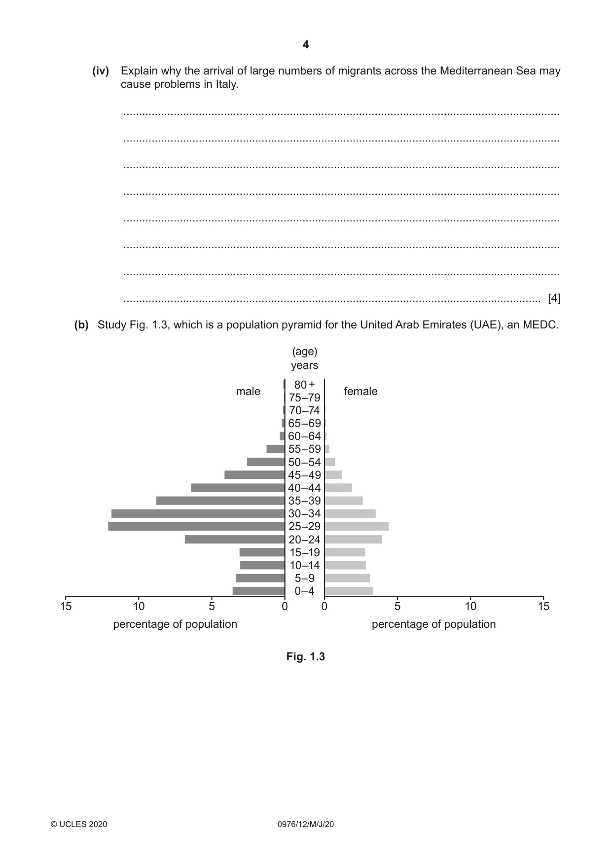
4 0976/12/M/J/20 © UCLES 2020 (iv) Explain why the arrival of large numbers of migrants across the Mediterranean Sea may cause problems in Italy. … … … … … … … … [4] (b) Study Fig. 1.3, which is a population pyramid for the United Arab Emirates (UAE), an MEDC. 0 0 5 5 10 10 percentage of population percentage of population 0–4 5–9 10–14 15–19 20–24 25–29 30–34 35–39 40–44 45–49 50–54 55–59 60–64 65–69 70–74 75–79 80 + male female (age) years 15 15 Fig. 1.3
Question paper, page 5
5 0976/12/M/J/20 © UCLES 2020 [Turn over (i) Identify three characteristics of the population pyramid for the UAE which suggest that it attracts many migrants. 1 … … 2 … … 3 … … [3] (ii) Most of the migration to the UAE is voluntary migration. Describe the attractions (pulls) of MEDCs, such as the UAE, to migrants from LEDCs. … … … … … … … … … … [5]
Question paper, page 6
6 0976/12/M/J/20 © UCLES 2020 (c) For a named country or area you have studied, explain why it is sparsely populated. Name of country or area … … … … … … … … … … … … … … … … … … … … … … … … … … … [7] [Total: 25]
Question paper, page 7
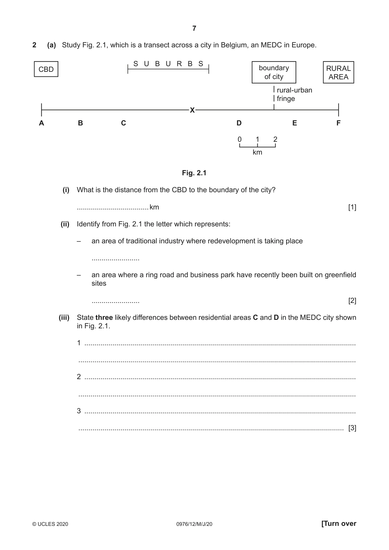
7 0976/12/M/J/20 © UCLES 2020 [Turn over 2 (a) Study Fig. 2.1, which is a transect across a city in Belgium, an MEDC in Europe. S U B U R B S A F B C D E CBD boundary of city rural-urban fringe RURAL AREA 0 1 2 km X Fig. 2.1 (i) What is the distance from the CBD to the boundary of the city? … km [1] (ii) Identify from Fig. 2.1 the letter which represents: – an area of traditional industry where redevelopment is taking place … – an area where a ring road and business park have recently been built on greenfield sites … [2] (iii) State three likely differences between residential areas C and D in the MEDC city shown in Fig. 2.1. 1 … … 2 … … 3 … … [3]
Question paper, page 8
8 0976/12/M/J/20 © UCLES 2020 (iv) Give two examples of low-order services which are likely to be located close to residential areas such as in area X in Fig. 2.1. Explain why many of the services in this area are likely to be low-order services. Example 1 … Example 2 … Explanation … … … … … … [4] (b) Study Fig. 2.2 (Insert), which is a photograph of part of an urban area in an LEDC which is being redeveloped. (i) Describe three features of the buildings in the redevelopment shown in Fig. 2.2. 1 … … 2 … … 3 … … [3] (ii) The land being redeveloped in Fig. 2.2 was previously used for a squatter settlement. Suggest how this change in land use is likely to have both benefits and problems. … … … … … … … … … … [5]
Question paper, page 9
9 0976/12/M/J/20 © UCLES 2020 [Turn over (c) For a named urban area you have studied, describe and explain the characteristics of its Central Business District (CBD). Name of urban area … … … … … … … … … … … … … … … … … … … … … … … … … … [7] [Total: 25]
Question paper, page 10
10 0976/12/M/J/20 © UCLES 2020 Section B Answer one question from this section. 3 (a) Study Fig. 3.1 (Insert), which is a photograph showing an area where coastal erosion has taken place. (i) Give one piece of evidence from Fig. 3.1 that the cliff has been eroded. … … [1] (ii) Explain how hydraulic action is likely to have eroded the cliff shown in Fig. 3.1. … … … … [2] (iii) Name one other process of coastal erosion. Explain how it is likely to have eroded the cliff shown in Fig. 3.1. Process of coastal erosion … Explanation … … … … … … [3] (iv) Managed retreat is a strategy where the coast is allowed to erode. Suggest reasons why the authorities decided to allow managed retreat to occur along the section of coastline shown in Fig. 3.1 rather than protecting it from erosion. … … … … … … … … [4]
Question paper, page 11
11 0976/12/M/J/20 © UCLES 2020 [Turn over (b) Study Fig. 3.2 (Insert), which is a photograph showing an area of mangroves. (i) Describe three characteristics of the mangroves shown in Fig. 3.2. 1 … … 2 … … 3 … … [3] (ii) Describe the conditions which are required for the development of a mangrove swamp. … … … … … … … … … … [5]
Question paper, page 12
12 0976/12/M/J/20 © UCLES 2020 (c) For a named coastal area you have studied, describe how it is being protected from coastal erosion. Name of area … … … … … … … … … … … … … … … … … … … … … … … … … … [7] [Total: 25]
Question paper, page 13
13 0976/12/M/J/20 © UCLES 2020 [Turn over 4 (a) Study Fig. 4.1 (Insert), which is a photograph of a weather instrument. (i) Identify the weather instrument shown in Fig. 4.1. … [1] (ii) Explain how readings are taken from the weather instrument shown in Fig. 4.1. … … … … [2] (iii) Describe and explain the ideal location of the weather instrument shown in Fig. 4.1. … … … … … … [3] (iv) Explain why many weather stations now use digital instruments rather than traditional ones. … … … … … … … … [4]
Question paper, page 14
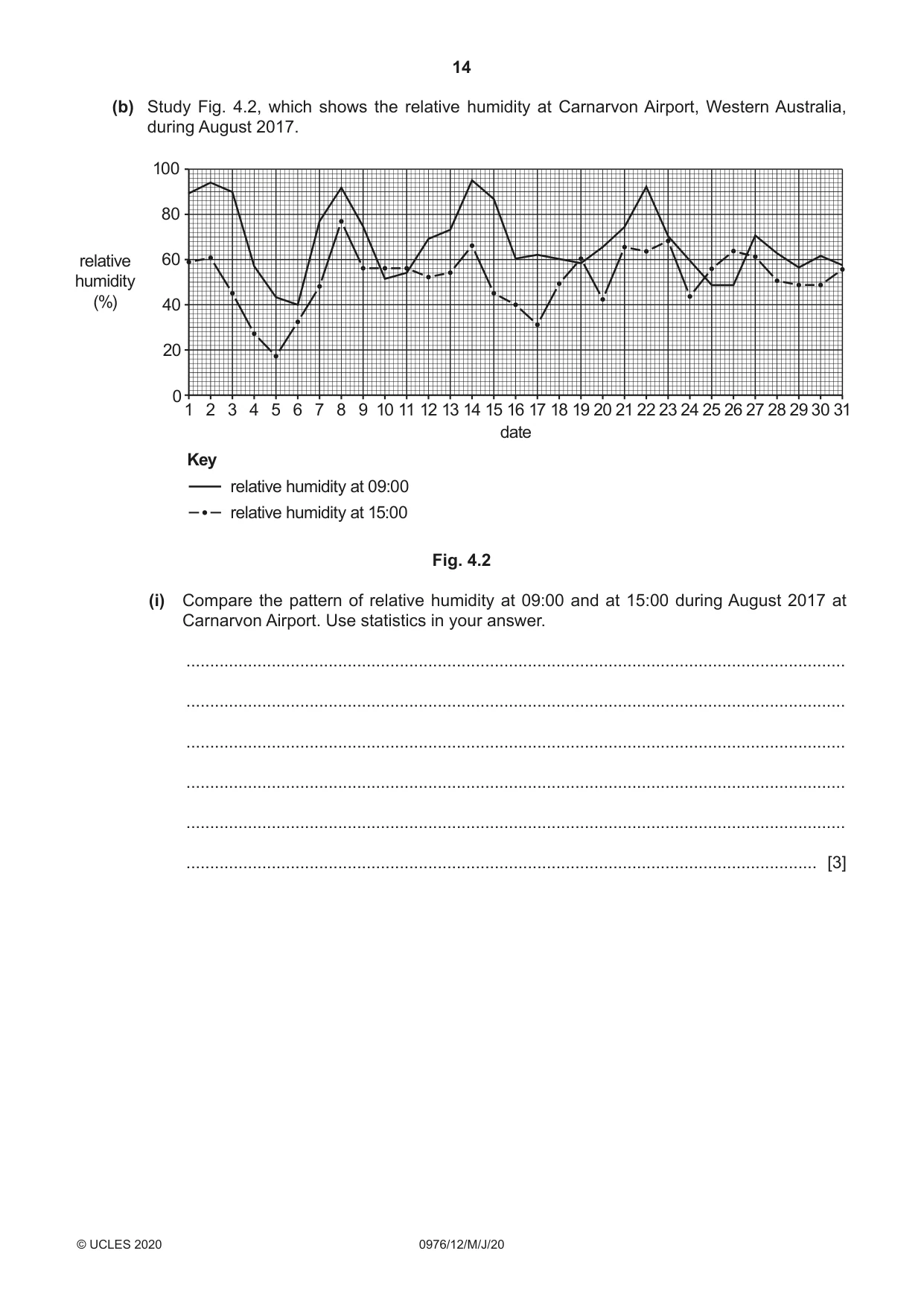
14 0976/12/M/J/20 © UCLES 2020 (b) Study Fig. 4.2, which shows the relative humidity at Carnarvon Airport, Western Australia, during August 2017. Key relative humidity at 09:00 relative humidity at 15:00 1 0 20 40 60 80 100 2 3 4 5 6 7 8 9 10 11 relative humidity (%) 12 13 14 15 16 17 18 date 19 20 21 22 23 24 25 26 27 28 29 30 31 Fig. 4.2 (i) Compare the pattern of relative humidity at 09:00 and at 15:00 during August 2017 at Carnarvon Airport. Use statistics in your answer. … … … … … … [3]
Question paper, page 15
15 0976/12/M/J/20 © UCLES 2020 [Turn over (ii) Explain how a traditional weather instrument can be used to obtain data on relative humidity such as that shown in Fig. 4.2. … … … … … … … … … … [5]
Question paper, page 16
16 0976/12/M/J/20 © UCLES 2020 (c) For a named hot desert you have studied, explain why the amount of rainfall in this area is low. Name of hot desert … … … … … … … … … … … … … … … … … … … … … … … … … … … [7] [Total: 25]
Question paper, page 17
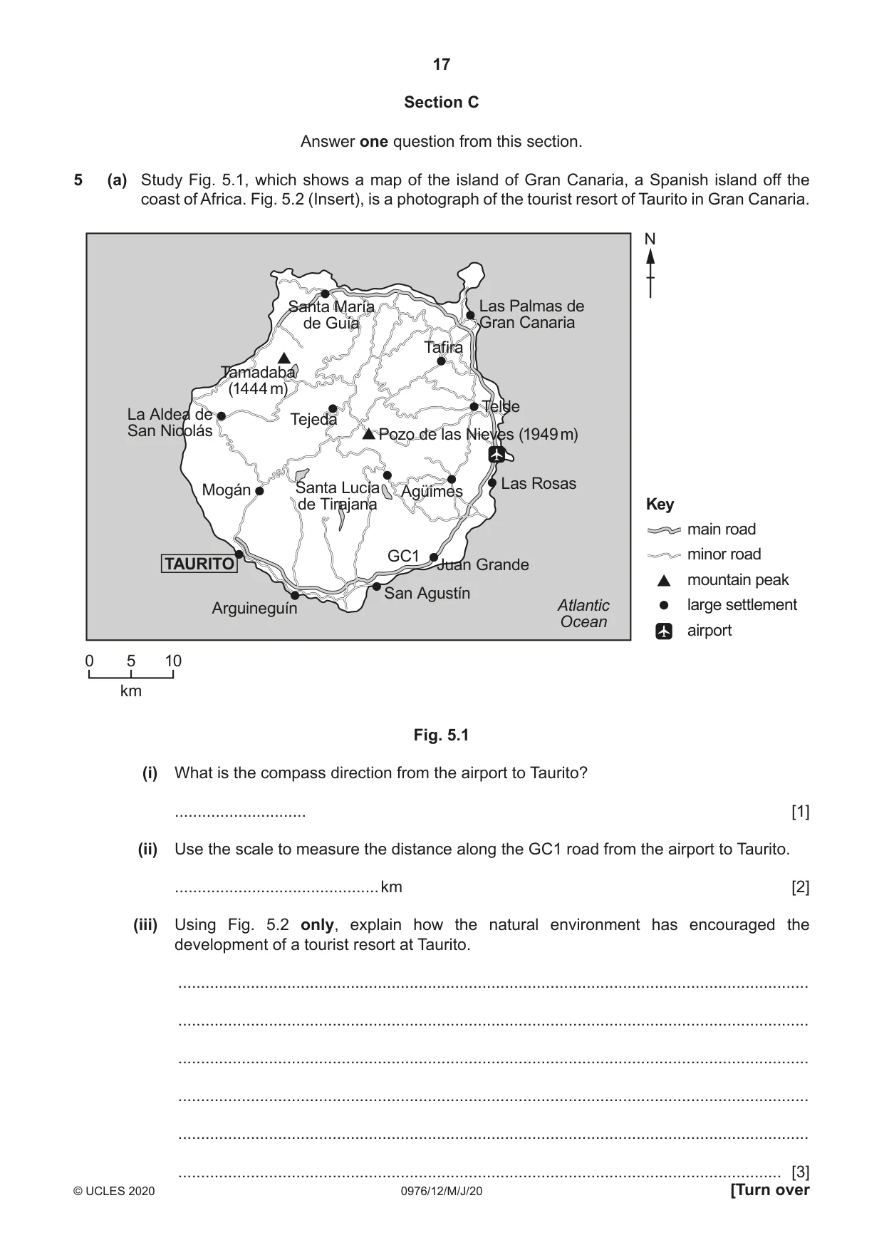
17 0976/12/M/J/20 © UCLES 2020 [Turn over Section C Answer one question from this section. 5 (a) Study Fig. 5.1, which shows a map of the island of Gran Canaria, a Spanish island off the coast of Africa. Fig. 5.2 (Insert), is a photograph of the tourist resort of Taurito in Gran Canaria. San Agustín Las Rosas Telde Tafira Tamadaba (1444 m) Santa María de Guía Las Palmas de Gran Canaria Tejeda Pozo de las Nieves (1949 m) Agüimes GC1 Juan Grande Arguineguín Mogán Santa Lucía de Tirajana La Aldea de San Nicolás Atlantic Ocean N 0 5 10 km Key main road minor road mountain peak large settlement airport TAURITO Fig. 5.1 (i) What is the compass direction from the airport to Taurito? … [1] (ii) Use the scale to measure the distance along the GC1 road from the airport to Taurito. … km [2] (iii) Using Fig. 5.2 only, explain how the natural environment has encouraged the development of a tourist resort at Taurito. … … … … … … [3]
Question paper, page 18
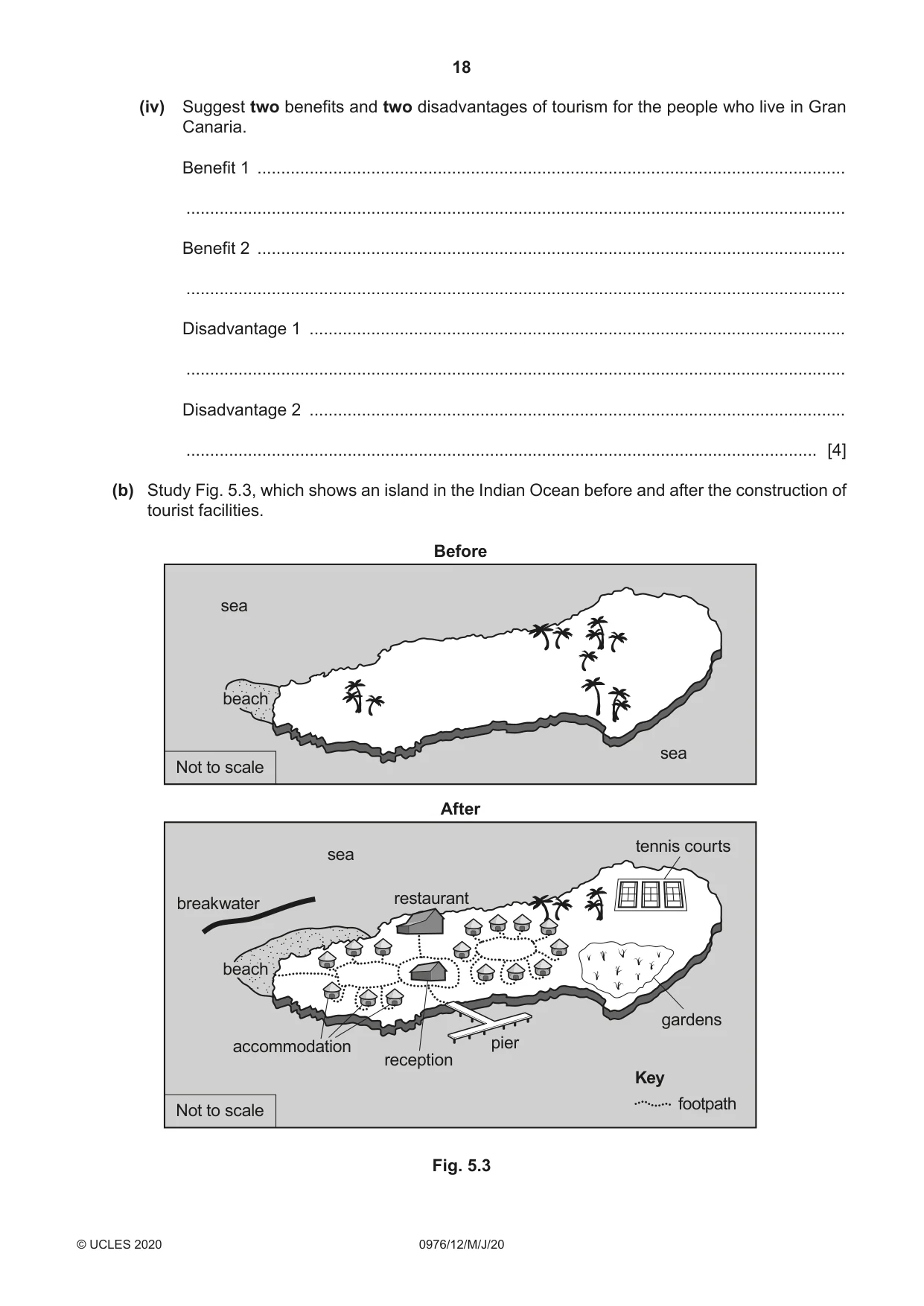
18 0976/12/M/J/20 © UCLES 2020 (iv) Suggest two benefits and two disadvantages of tourism for the people who live in Gran Canaria. Benefit 1 … … Benefit 2 … … Disadvantage 1 … … Disadvantage 2 … … [4] (b) Study Fig. 5.3, which shows an island in the Indian Ocean before and after the construction of tourist facilities. Key footpath sea accommodation pier restaurant After Before reception gardens Not to scale Not to scale tennis courts sea sea breakwater beach beach Fig. 5.3
Question paper, page 19
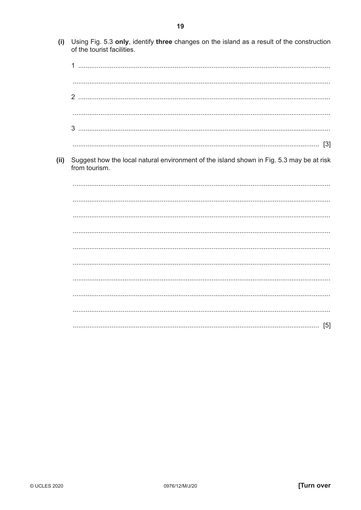
19 0976/12/M/J/20 © UCLES 2020 [Turn over (i) Using Fig. 5.3 only, identify three changes on the island as a result of the construction of the tourist facilities. 1 … … 2 … … 3 … … [3] (ii) Suggest how the local natural environment of the island shown in Fig. 5.3 may be at risk from tourism. … … … … … … … … … … [5]
Question paper, page 20
20 0976/12/M/J/20 © UCLES 2020 (c) For a named area you have studied where tourism is important, explain how it is managed so that the risks to the natural environment are reduced. Name of area … … … … … … … … … … … … … … … … … … … … … … … … … … [7] [Total: 25]
Question paper, page 21
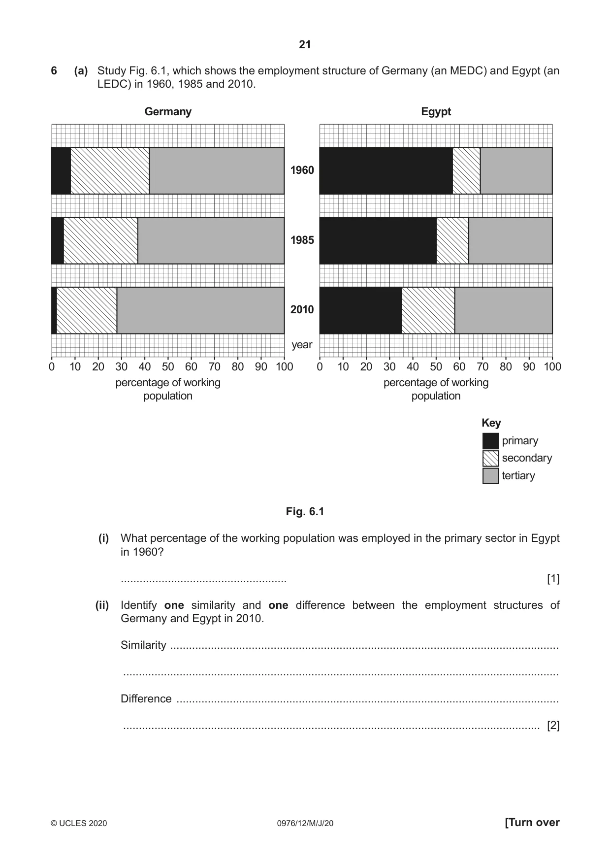
21 0976/12/M/J/20 © UCLES 2020 [Turn over 6 (a) Study Fig. 6.1, which shows the employment structure of Germany (an MEDC) and Egypt (an LEDC) in 1960, 1985 and 2010. 0 10 20 30 40 50 percentage of working population Germany 60 70 80 90 100 0 10 20 30 40 50 percentage of working population Egypt 60 70 80 90 100 2010 year 1985 1960 Key primary secondary tertiary Fig. 6.1 (i) What percentage of the working population was employed in the primary sector in Egypt in 1960? … [1] (ii) Identify one similarity and one difference between the employment structures of Germany and Egypt in 2010. Similarity … … Difference … … [2]
Question paper, page 22
22 0976/12/M/J/20 © UCLES 2020 (iii) Suggest reasons for the decline of employment in secondary industry in Germany since 1985. … … … … … … … [3] (iv) Suggest reasons for the growth of tertiary employment in Egypt between 1960 and 2010. … … … … … … … … [4]
Question paper, page 23
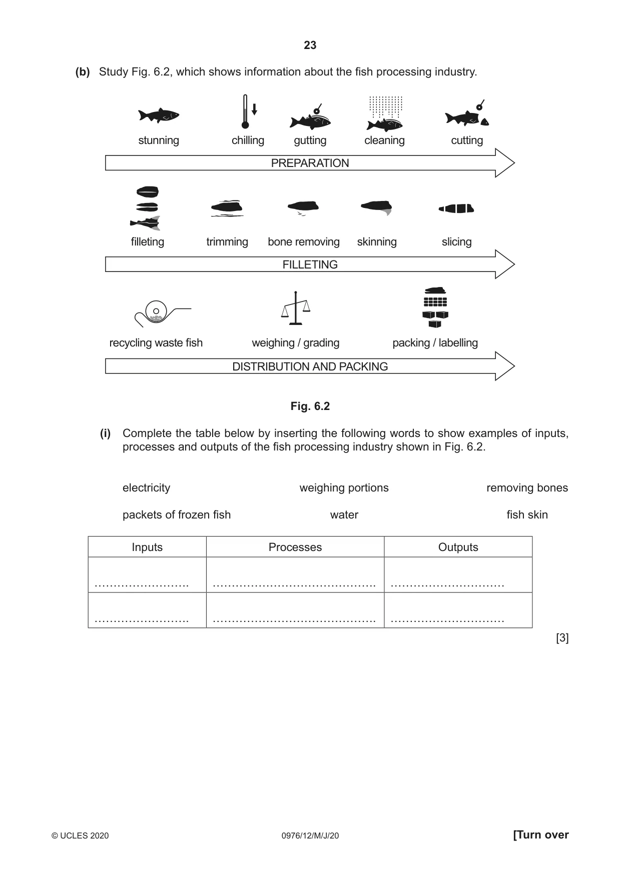
23 0976/12/M/J/20 © UCLES 2020 [Turn over (b) Study Fig. 6.2, which shows information about the fish processing industry. stunning chilling gutting cleaning cutting PREPARATION FILLETING filleting trimming bone removing skinning slicing DISTRIBUTION AND PACKING recycling waste fish weighing / grading packing / labelling Fig. 6.2 (i) Complete the table below by inserting the following words to show examples of inputs, processes and outputs of the fish processing industry shown in Fig. 6.2. electricity weighing portions removing bones packets of frozen fish water fish skin Inputs Processes Outputs ……………………. ……………………………………. ………………………… ……………………. ……………………………………. ………………………… [3]
Question paper, page 24
24 0976/12/M/J/20 © UCLES 2020 (ii) Explain how the local natural environment may be at risk from industries such as fish processing. … … … … … … … … … … [5]
Question paper, page 25
25 0976/12/M/J/20 © UCLES 2020 (c) For a named example you have studied, describe and explain the location of a factory or industrial zone. Name of factory or industrial zone … … … … … … … … … … … … … … … … … … … … … … … … … … [7] [Total: 25]
Question paper, page 26
26 0976/12/M/J/20 © UCLES 2020 Additional Pages If you use the following lined pages to complete the answer(s) to any question(s), the question number(s) must be clearly shown. … … … … … … … … … … … … … … … … … … … … … … … … … …
Question paper, page 27
27 0976/12/M/J/20 © UCLES 2020 … … … … … … … … … … … … … … … … … … … … … … … … … … … …
Question paper, page 28
28 0976/12/M/J/20 © UCLES 2020 BLANK PAGE Permission to reproduce items where third-party owned material protected by copyright is included has been sought and cleared where possible. Every reasonable effort has been made by the publisher (UCLES) to trace copyright holders, but if any items requiring clearance have unwittingly been included, the publisher will be pleased to make amends at the earliest possible opportunity. To avoid the issue of disclosure of answer-related information to candidates, all copyright acknowledgements are reproduced online in the Cambridge Assessment International Education Copyright Acknowledgements Booklet. This is produced for each series of examinations and is freely available to download at www.cambridgeinternational.org after the live examination series. Cambridge Assessment International Education is part of the Cambridge Assessment Group. Cambridge Assessment is the brand name of the University of Cambridge Local Examinations Syndicate (UCLES), which itself is a department of the University of Cambridge.
Mark scheme, page 1
This document consists of 15 printed pages. © UCLES 2020 [Turn over Cambridge IGCSE™ (9–1) IGCSE GEOGRAPHY (9–1) 0976/12 Paper 1 May/June 2020 MARK SCHEME Maximum Mark: 75 Published Students did not sit exam papers in the June 2020 series due to the Covid-19 global pandemic. This mark scheme is published to support teachers and students and should be read together with the question paper. It shows the requirements of the exam. The answer column of the mark scheme shows the proposed basis on which Examiners would award marks for this exam. Where appropriate, this column also provides the most likely acceptable alternative responses expected from students. Examiners usually review the mark scheme after they have seen student responses and update the mark scheme if appropriate. In the June series, Examiners were unable to consider the acceptability of alternative responses, as there were no student responses to consider. Mark schemes should usually be read together with the Principal Examiner Report for Teachers. However, because students did not sit exam papers, there is no Principal Examiner Report for Teachers for the June 2020 series. Cambridge International will not enter into discussions about these mark schemes. Cambridge International is publishing the mark schemes for the June 2020 series for most Cambridge IGCSE™ and Cambridge International A & AS Level components, and some Cambridge O Level components.
Mark scheme, page 2
0976/12 Cambridge IGCSE (9–1) – Mark Scheme PUBLISHED May/June 2020 © UCLES 2020 Page 2 of 15 Generic Marking Principles These general marking principles must be applied by all examiners when marking candidate answers. They should be applied alongside the specific content of the mark scheme or generic level descriptors for a question. Each question paper and mark scheme will also comply with these marking principles. GENERIC MARKING PRINCIPLE 1: Marks must be awarded in line with: • the specific content of the mark scheme or the generic level descriptors for the question • the specific skills defined in the mark scheme or in the generic level descriptors for the question • the standard of response required by a candidate as exemplified by the standardisation scripts. GENERIC MARKING PRINCIPLE 2: Marks awarded are always whole marks (not half marks, or other fractions). GENERIC MARKING PRINCIPLE 3: Marks must be awarded positively: • marks are awarded for correct/valid answers, as defined in the mark scheme. However, credit is given for valid answers which go beyond the scope of the syllabus and mark scheme, referring to your Team Leader as appropriate • marks are awarded when candidates clearly demonstrate what they know and can do • marks are not deducted for errors • marks are not deducted for omissions • answers should only be judged on the quality of spelling, punctuation and grammar when these features are specifically assessed by the question as indicated by the mark scheme. The meaning, however, should be unambiguous. GENERIC MARKING PRINCIPLE 4: Rules must be applied consistently e.g. in situations where candidates have not followed instructions or in the application of generic level descriptors. GENERIC MARKING PRINCIPLE 5: Marks should be awarded using the full range of marks defined in the mark scheme for the question (however; the use of the full mark range may be limited according to the quality of the candidate responses seen). GENERIC MARKING PRINCIPLE 6: Marks awarded are based solely on the requirements as defined in the mark scheme. Marks should not be awarded with grade thresholds or grade descriptors in mind.
Mark scheme, page 3
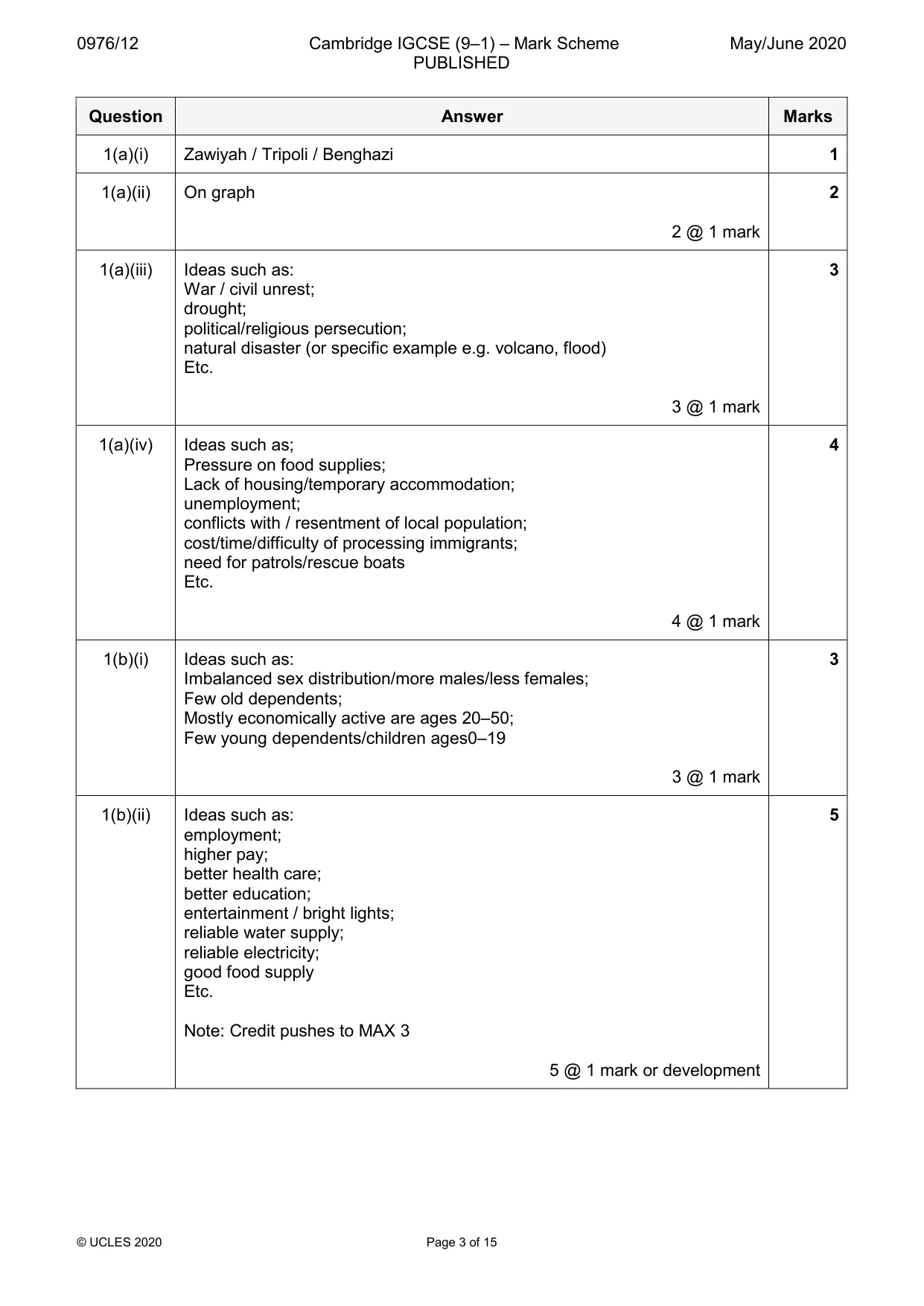
0976/12 Cambridge IGCSE (9–1) – Mark Scheme PUBLISHED May/June 2020 © UCLES 2020 Page 3 of 15 Question Answer Marks 1(a)(i) Zawiyah / Tripoli / Benghazi 1 1(a)(ii) On graph 2 @ 1 mark 2 1(a)(iii) Ideas such as: War / civil unrest; drought; political/religious persecution; natural disaster (or specific example e.g. volcano, flood) Etc. 3 @ 1 mark 3 1(a)(iv) Ideas such as; Pressure on food supplies; Lack of housing/temporary accommodation; unemployment; conflicts with / resentment of local population; cost/time/difficulty of processing immigrants; need for patrols/rescue boats Etc. 4 @ 1 mark 4 1(b)(i) Ideas such as: Imbalanced sex distribution/more males/less females; Few old dependents; Mostly economically active are ages 20–50; Few young dependents/children ages0–19 3 @ 1 mark 3 1(b)(ii) Ideas such as: employment; higher pay; better health care; better education; entertainment / bright lights; reliable water supply; reliable electricity; good food supply Etc. Note: Credit pushes to MAX 3 5 @ 1 mark or development 5
Mark scheme, page 4
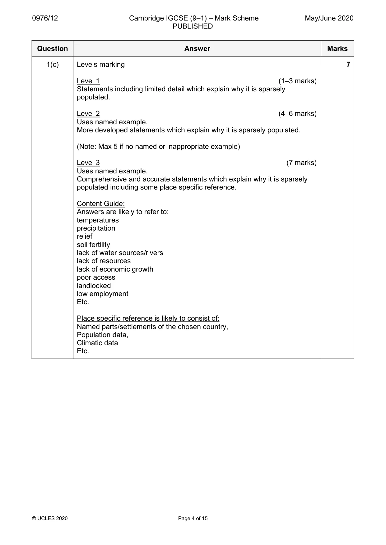
0976/12 Cambridge IGCSE (9–1) – Mark Scheme PUBLISHED May/June 2020 © UCLES 2020 Page 4 of 15 Question Answer Marks 1(c) Levels marking Level 1 (1–3 marks) Statements including limited detail which explain why it is sparsely populated. Level 2 (4–6 marks) Uses named example. More developed statements which explain why it is sparsely populated. (Note: Max 5 if no named or inappropriate example) Level 3 (7 marks) Uses named example. Comprehensive and accurate statements which explain why it is sparsely populated including some place specific reference. Content Guide: Answers are likely to refer to: temperatures precipitation relief soil fertility lack of water sources/rivers lack of resources lack of economic growth poor access landlocked low employment Etc. Place specific reference is likely to consist of: Named parts/settlements of the chosen country, Population data, Climatic data Etc. 7
Mark scheme, page 5
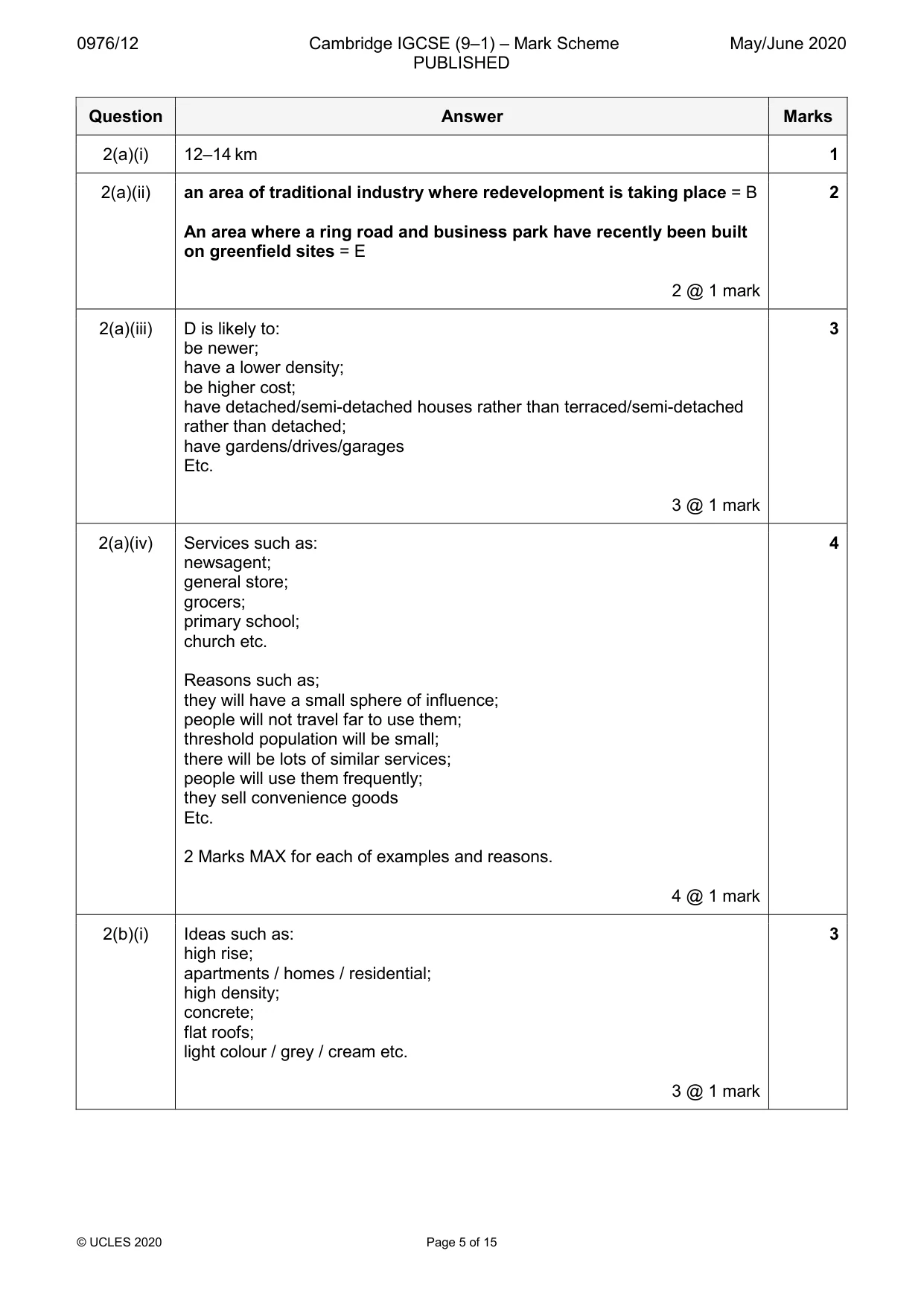
0976/12 Cambridge IGCSE (9–1) – Mark Scheme PUBLISHED May/June 2020 © UCLES 2020 Page 5 of 15 Question Answer Marks 2(a)(i) 12–14 km 1 2(a)(ii) an area of traditional industry where redevelopment is taking place = B An area where a ring road and business park have recently been built on greenfield sites = E 2 @ 1 mark 2 2(a)(iii) D is likely to: be newer; have a lower density; be higher cost; have detached/semi-detached houses rather than terraced/semi-detached rather than detached; have gardens/drives/garages Etc. 3 @ 1 mark 3 2(a)(iv) Services such as: newsagent; general store; grocers; primary school; church etc. Reasons such as; they will have a small sphere of influence; people will not travel far to use them; threshold population will be small; there will be lots of similar services; people will use them frequently; they sell convenience goods Etc. 2 Marks MAX for each of examples and reasons. 4 @ 1 mark 4 2(b)(i) Ideas such as: high rise; apartments / homes / residential; high density; concrete; flat roofs; light colour / grey / cream etc. 3 @ 1 mark 3
Mark scheme, page 6
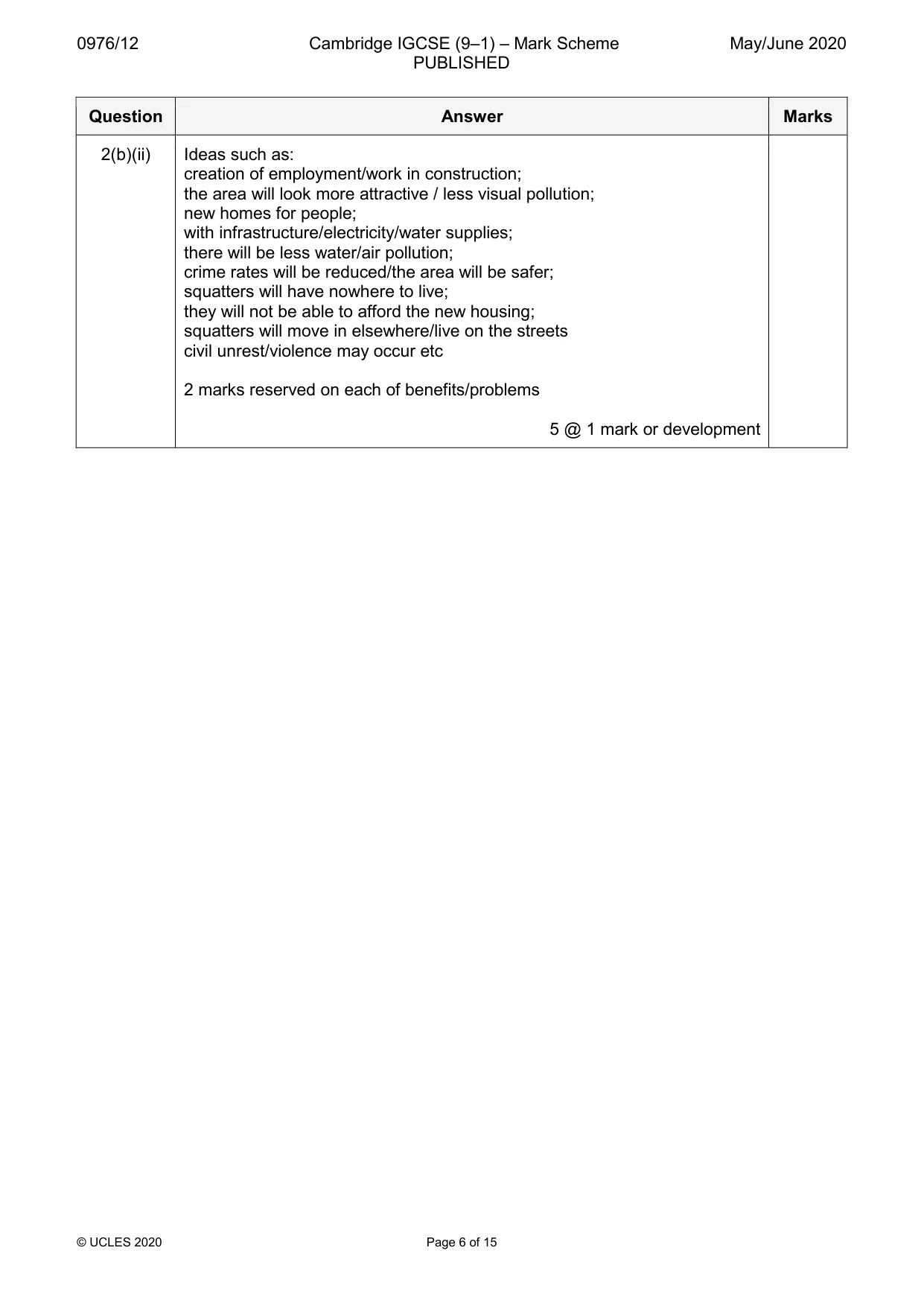
0976/12 Cambridge IGCSE (9–1) – Mark Scheme PUBLISHED May/June 2020 © UCLES 2020 Page 6 of 15 Question Answer Marks 2(b)(ii) Ideas such as: creation of employment/work in construction; the area will look more attractive / less visual pollution; new homes for people; with infrastructure/electricity/water supplies; there will be less water/air pollution; crime rates will be reduced/the area will be safer; squatters will have nowhere to live; they will not be able to afford the new housing; squatters will move in elsewhere/live on the streets civil unrest/violence may occur etc 2 marks reserved on each of benefits/problems 5 @ 1 mark or development
Mark scheme, page 7
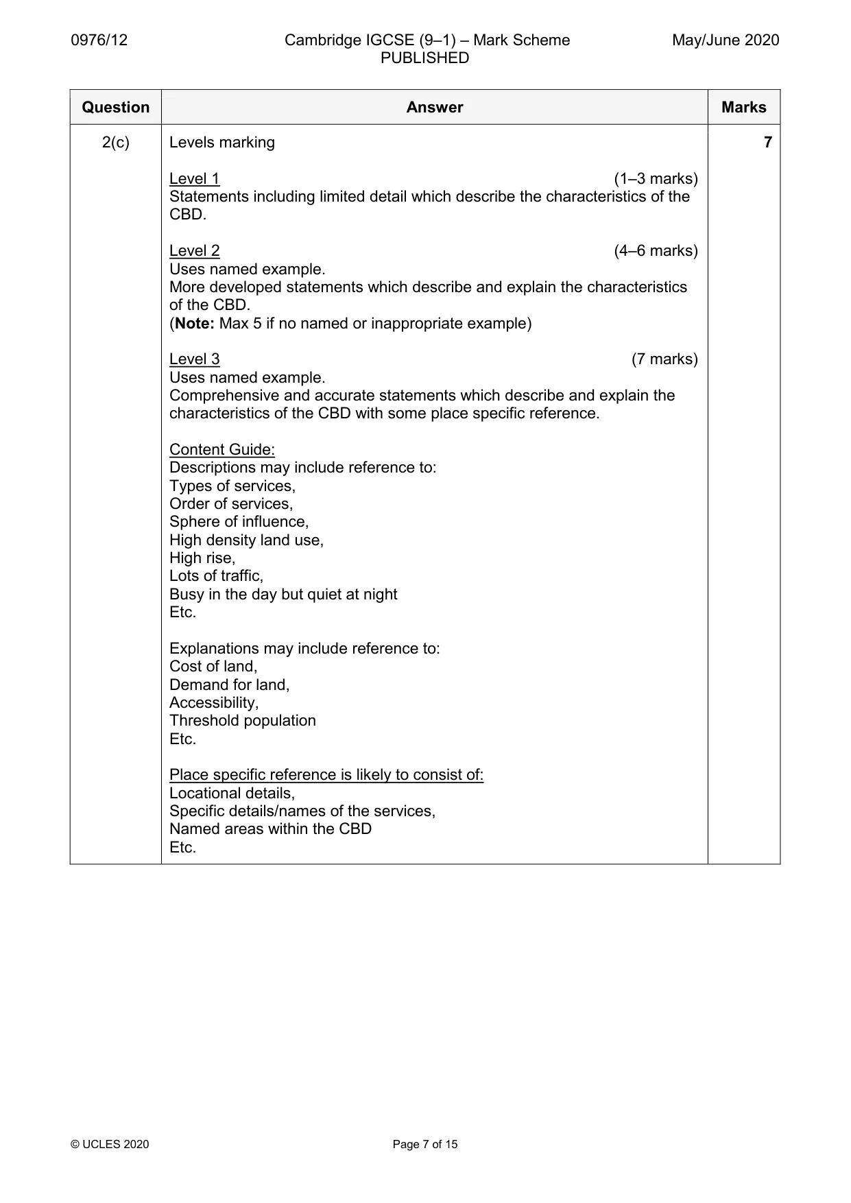
0976/12 Cambridge IGCSE (9–1) – Mark Scheme PUBLISHED May/June 2020 © UCLES 2020 Page 7 of 15 Question Answer Marks 2(c) Levels marking Level 1 (1–3 marks) Statements including limited detail which describe the characteristics of the CBD. Level 2 (4–6 marks) Uses named example. More developed statements which describe and explain the characteristics of the CBD. (Note: Max 5 if no named or inappropriate example) Level 3 (7 marks) Uses named example. Comprehensive and accurate statements which describe and explain the characteristics of the CBD with some place specific reference. Content Guide: Descriptions may include reference to: Types of services, Order of services, Sphere of influence, High density land use, High rise, Lots of traffic, Busy in the day but quiet at night Etc. Explanations may include reference to: Cost of land, Demand for land, Accessibility, Threshold population Etc. Place specific reference is likely to consist of: Locational details, Specific details/names of the services, Named areas within the CBD Etc. 7
Mark scheme, page 8
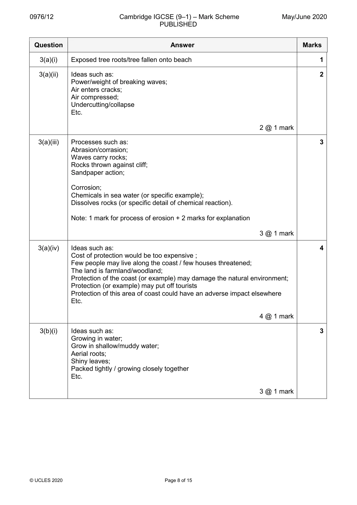
0976/12 Cambridge IGCSE (9–1) – Mark Scheme PUBLISHED May/June 2020 © UCLES 2020 Page 8 of 15 Question Answer Marks 3(a)(i) Exposed tree roots/tree fallen onto beach 1 3(a)(ii) Ideas such as: Power/weight of breaking waves; Air enters cracks; Air compressed; Undercutting/collapse Etc. 2 @ 1 mark 2 3(a)(iii) Processes such as: Abrasion/corrasion; Waves carry rocks; Rocks thrown against cliff; Sandpaper action; Corrosion; Chemicals in sea water (or specific example); Dissolves rocks (or specific detail of chemical reaction). Note: 1 mark for process of erosion + 2 marks for explanation 3 @ 1 mark 3 3(a)(iv) Ideas such as: Cost of protection would be too expensive ; Few people may live along the coast / few houses threatened; The land is farmland/woodland; Protection of the coast (or example) may damage the natural environment; Protection (or example) may put off tourists Protection of this area of coast could have an adverse impact elsewhere Etc. 4 @ 1 mark 4 3(b)(i) Ideas such as: Growing in water; Grow in shallow/muddy water; Aerial roots; Shiny leaves; Packed tightly / growing closely together Etc. 3 @ 1 mark 3
Mark scheme, page 9
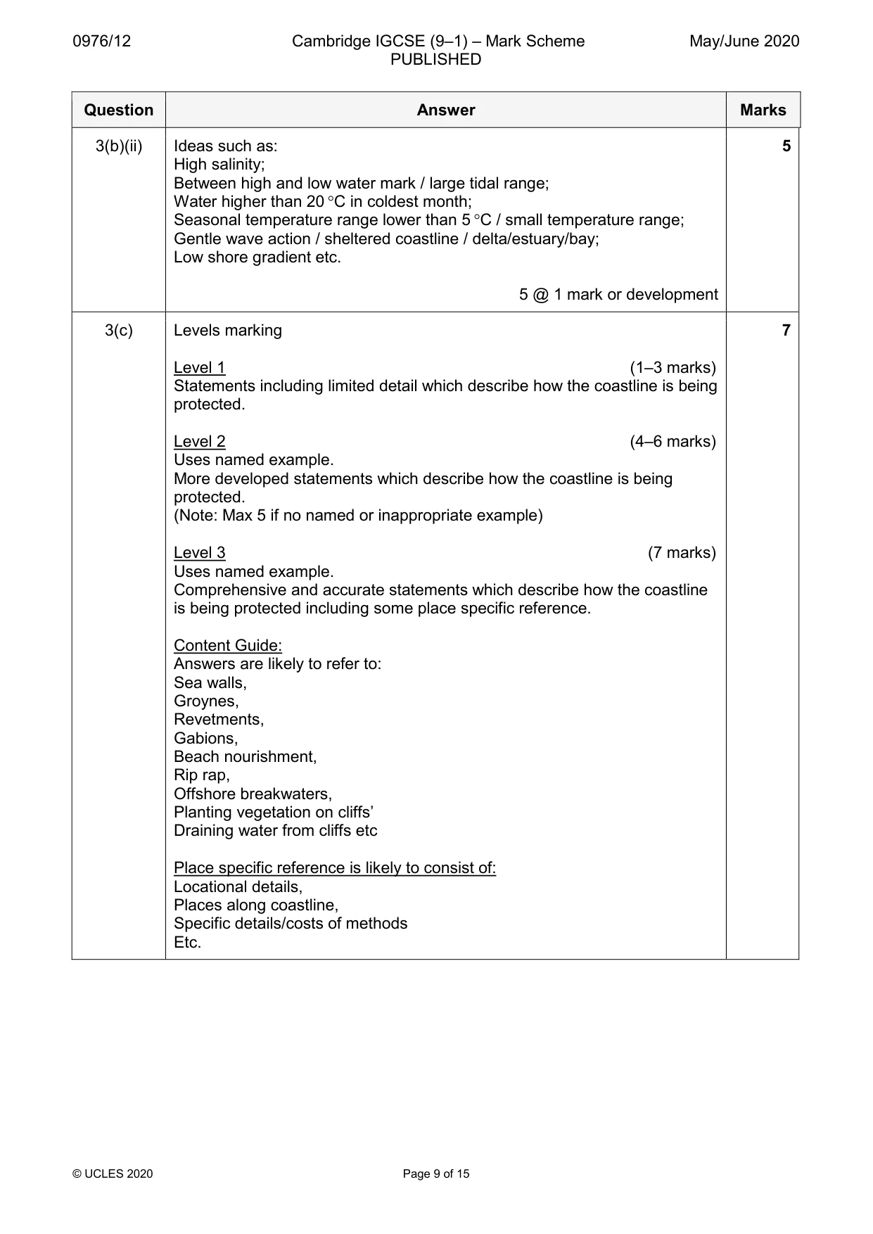
0976/12 Cambridge IGCSE (9–1) – Mark Scheme PUBLISHED May/June 2020 © UCLES 2020 Page 9 of 15 Question Answer Marks 3(b)(ii) Ideas such as: High salinity; Between high and low water mark / large tidal range; Water higher than 20 °C in coldest month; Seasonal temperature range lower than 5 °C / small temperature range; Gentle wave action / sheltered coastline / delta/estuary/bay; Low shore gradient etc. 5 @ 1 mark or development 5 3(c) Levels marking Level 1 (1–3 marks) Statements including limited detail which describe how the coastline is being protected. Level 2 (4–6 marks) Uses named example. More developed statements which describe how the coastline is being protected. (Note: Max 5 if no named or inappropriate example) Level 3 (7 marks) Uses named example. Comprehensive and accurate statements which describe how the coastline is being protected including some place specific reference. Content Guide: Answers are likely to refer to: Sea walls, Groynes, Revetments, Gabions, Beach nourishment, Rip rap, Offshore breakwaters, Planting vegetation on cliffs’ Draining water from cliffs etc Place specific reference is likely to consist of: Locational details, Places along coastline, Specific details/costs of methods Etc. 7
Mark scheme, page 10
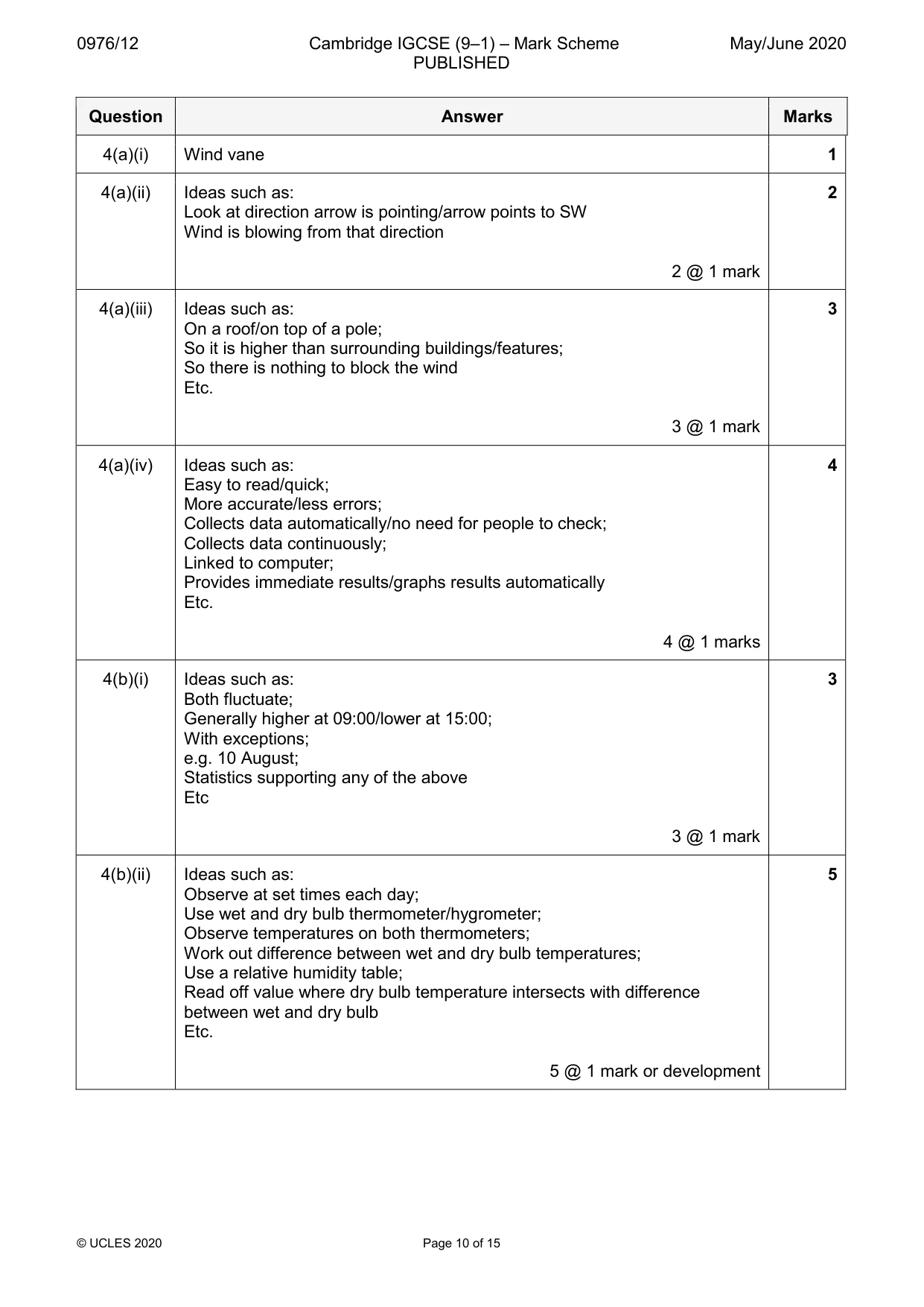
0976/12 Cambridge IGCSE (9–1) – Mark Scheme PUBLISHED May/June 2020 © UCLES 2020 Page 10 of 15 Question Answer Marks 4(a)(i) Wind vane 1 4(a)(ii) Ideas such as: Look at direction arrow is pointing/arrow points to SW Wind is blowing from that direction 2 @ 1 mark 2 4(a)(iii) Ideas such as: On a roof/on top of a pole; So it is higher than surrounding buildings/features; So there is nothing to block the wind Etc. 3 @ 1 mark 3 4(a)(iv) Ideas such as: Easy to read/quick; More accurate/less errors; Collects data automatically/no need for people to check; Collects data continuously; Linked to computer; Provides immediate results/graphs results automatically Etc. 4 @ 1 marks 4 4(b)(i) Ideas such as: Both fluctuate; Generally higher at 09:00/lower at 15:00; With exceptions; e.g. 10 August; Statistics supporting any of the above Etc 3 @ 1 mark 3 4(b)(ii) Ideas such as: Observe at set times each day; Use wet and dry bulb thermometer/hygrometer; Observe temperatures on both thermometers; Work out difference between wet and dry bulb temperatures; Use a relative humidity table; Read off value where dry bulb temperature intersects with difference between wet and dry bulb Etc. 5 @ 1 mark or development 5
Mark scheme, page 11
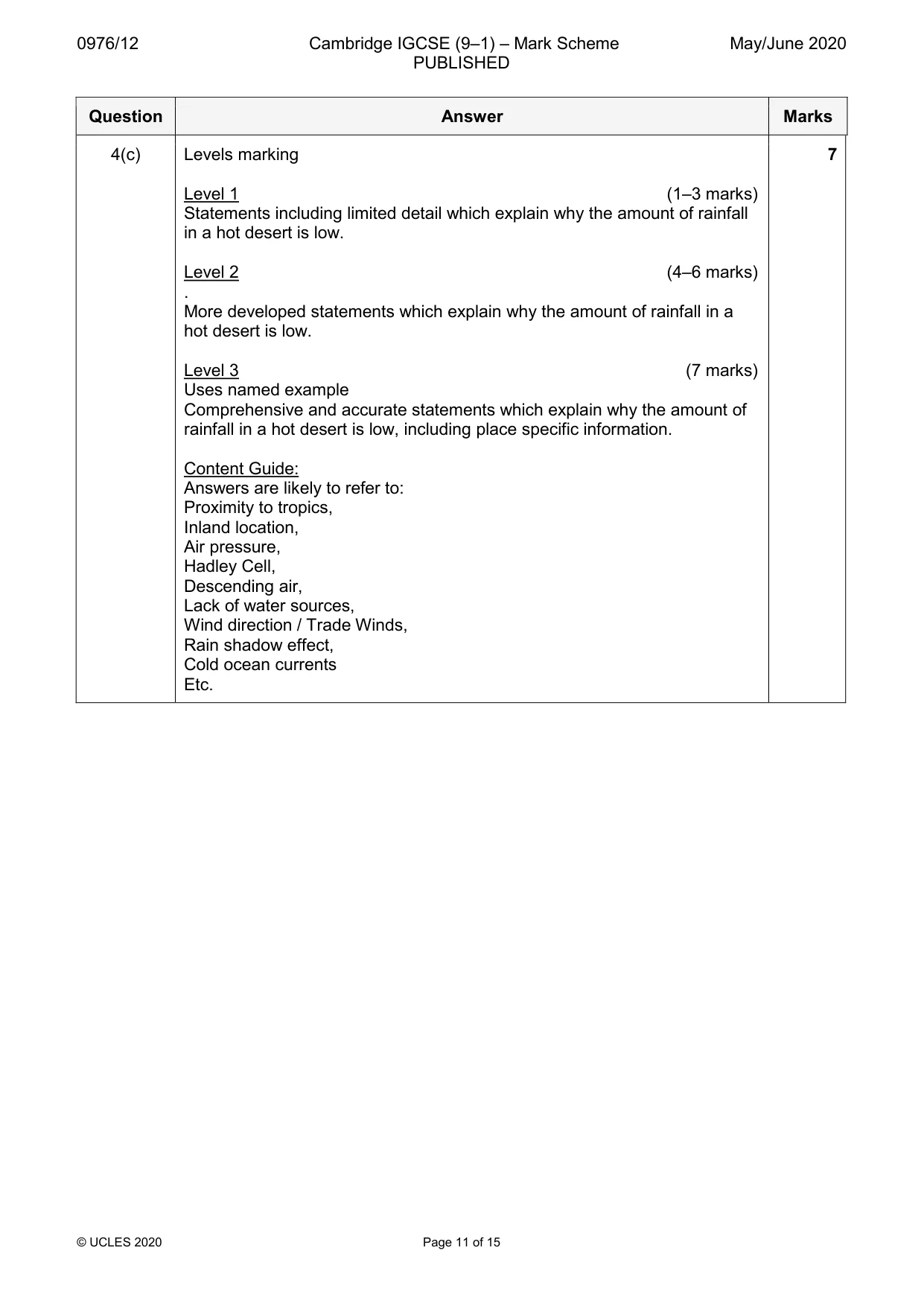
0976/12 Cambridge IGCSE (9–1) – Mark Scheme PUBLISHED May/June 2020 © UCLES 2020 Page 11 of 15 Question Answer Marks 4(c) Levels marking Level 1 (1–3 marks) Statements including limited detail which explain why the amount of rainfall in a hot desert is low. Level 2 (4–6 marks) . More developed statements which explain why the amount of rainfall in a hot desert is low. Level 3 (7 marks) Uses named example Comprehensive and accurate statements which explain why the amount of rainfall in a hot desert is low, including place specific information. Content Guide: Answers are likely to refer to: Proximity to tropics, Inland location, Air pressure, Hadley Cell, Descending air, Lack of water sources, Wind direction / Trade Winds, Rain shadow effect, Cold ocean currents Etc. 7
Mark scheme, page 12
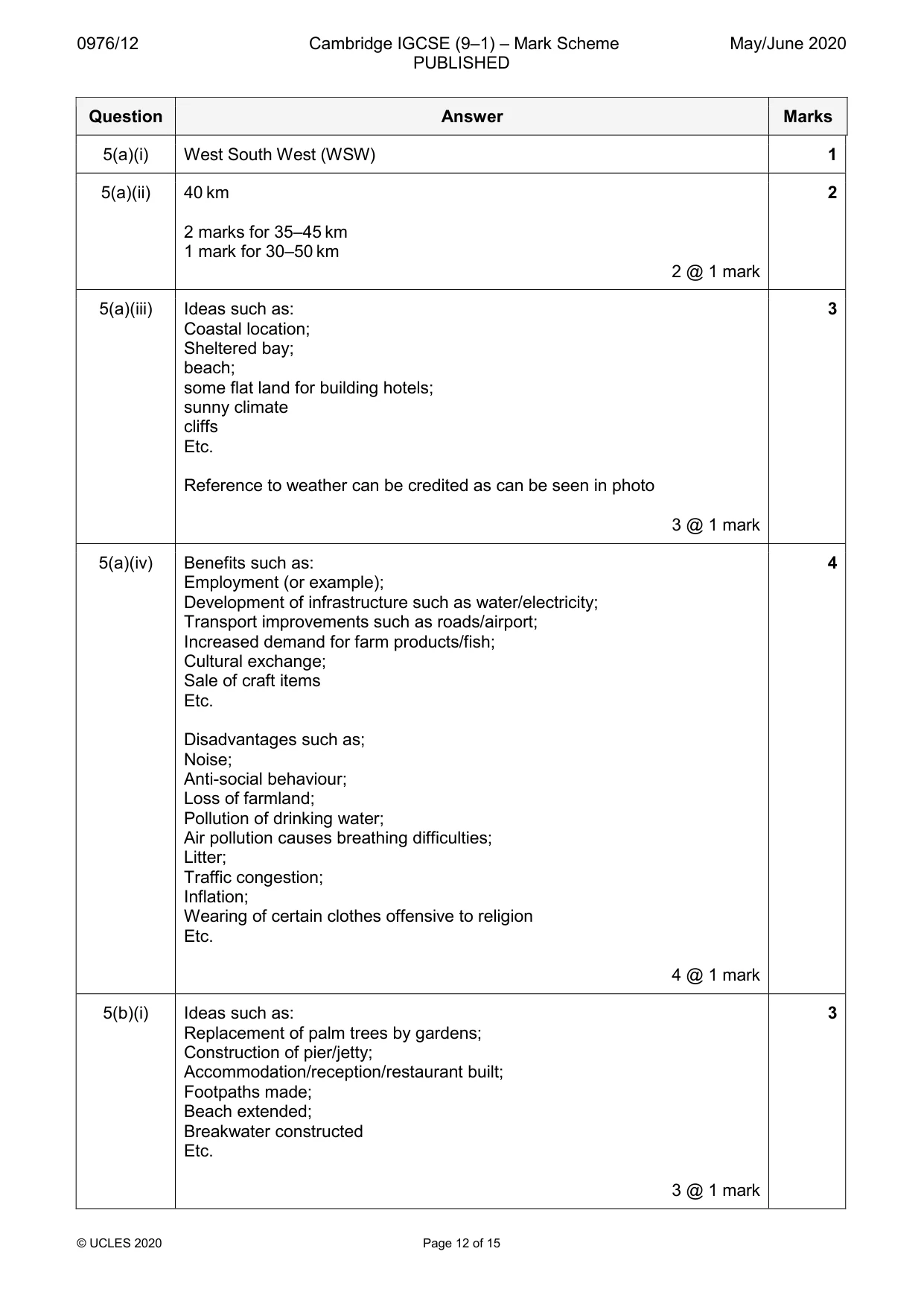
0976/12 Cambridge IGCSE (9–1) – Mark Scheme PUBLISHED May/June 2020 © UCLES 2020 Page 12 of 15 Question Answer Marks 5(a)(i) West South West (WSW) 1 5(a)(ii) 40 km 2 marks for 35–45 km 1 mark for 30–50 km 2 @ 1 mark 2 5(a)(iii) Ideas such as: Coastal location; Sheltered bay; beach; some flat land for building hotels; sunny climate cliffs Etc. Reference to weather can be credited as can be seen in photo 3 @ 1 mark 3 5(a)(iv) Benefits such as: Employment (or example); Development of infrastructure such as water/electricity; Transport improvements such as roads/airport; Increased demand for farm products/fish; Cultural exchange; Sale of craft items Etc. Disadvantages such as; Noise; Anti-social behaviour; Loss of farmland; Pollution of drinking water; Air pollution causes breathing difficulties; Litter; Traffic congestion; Inflation; Wearing of certain clothes offensive to religion Etc. 4 @ 1 mark 4 5(b)(i) Ideas such as: Replacement of palm trees by gardens; Construction of pier/jetty; Accommodation/reception/restaurant built; Footpaths made; Beach extended; Breakwater constructed Etc. 3 @ 1 mark 3
Mark scheme, page 13
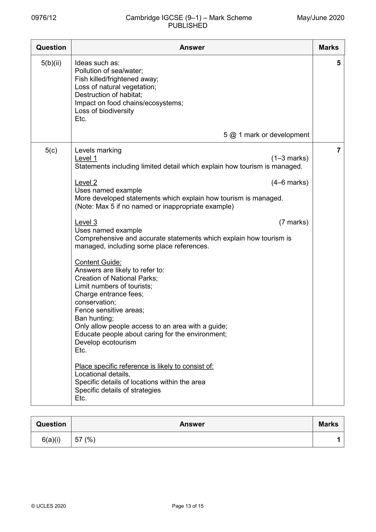
0976/12 Cambridge IGCSE (9–1) – Mark Scheme PUBLISHED May/June 2020 © UCLES 2020 Page 13 of 15 Question Answer Marks 5(b)(ii) Ideas such as: Pollution of sea/water; Fish killed/frightened away; Loss of natural vegetation; Destruction of habitat; Impact on food chains/ecosystems; Loss of biodiversity Etc. 5 @ 1 mark or development 5 5(c) Levels marking Level 1 (1–3 marks) Statements including limited detail which explain how tourism is managed. Level 2 (4–6 marks) Uses named example More developed statements which explain how tourism is managed. (Note: Max 5 if no named or inappropriate example) Level 3 (7 marks) Uses named example Comprehensive and accurate statements which explain how tourism is managed, including some place references. Content Guide: Answers are likely to refer to: Creation of National Parks; Limit numbers of tourists; Charge entrance fees; conservation; Fence sensitive areas; Ban hunting; Only allow people access to an area with a guide; Educate people about caring for the environment; Develop ecotourism Etc. Place specific reference is likely to consist of: Locational details, Specific details of locations within the area Specific details of strategies Etc. 7 Question Answer Marks 6(a)(i) 57 (%) 1
Mark scheme, page 14
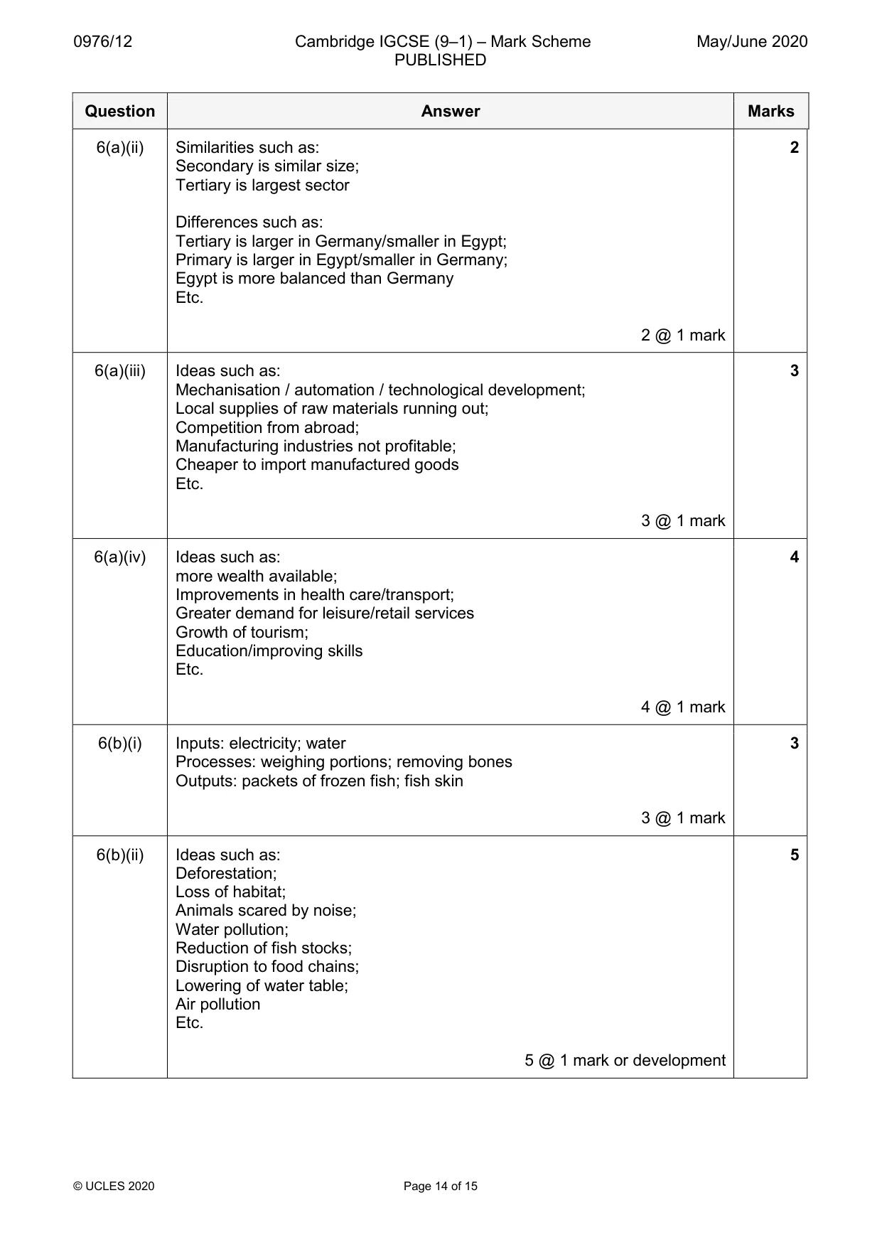
0976/12 Cambridge IGCSE (9–1) – Mark Scheme PUBLISHED May/June 2020 © UCLES 2020 Page 14 of 15 Question Answer Marks 6(a)(ii) Similarities such as: Secondary is similar size; Tertiary is largest sector Differences such as: Tertiary is larger in Germany/smaller in Egypt; Primary is larger in Egypt/smaller in Germany; Egypt is more balanced than Germany Etc. 2 @ 1 mark 2 6(a)(iii) Ideas such as: Mechanisation / automation / technological development; Local supplies of raw materials running out; Competition from abroad; Manufacturing industries not profitable; Cheaper to import manufactured goods Etc. 3 @ 1 mark 3 6(a)(iv) Ideas such as: more wealth available; Improvements in health care/transport; Greater demand for leisure/retail services Growth of tourism; Education/improving skills Etc. 4 @ 1 mark 4 6(b)(i) Inputs: electricity; water Processes: weighing portions; removing bones Outputs: packets of frozen fish; fish skin 3 @ 1 mark 3 6(b)(ii) Ideas such as: Deforestation; Loss of habitat; Animals scared by noise; Water pollution; Reduction of fish stocks; Disruption to food chains; Lowering of water table; Air pollution Etc. 5 @ 1 mark or development 5
Mark scheme, page 15
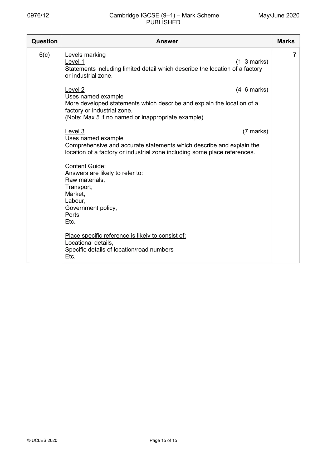
0976/12 Cambridge IGCSE (9–1) – Mark Scheme PUBLISHED May/June 2020 © UCLES 2020 Page 15 of 15 Question Answer Marks 6(c) Levels marking Level 1 (1–3 marks) Statements including limited detail which describe the location of a factory or industrial zone. Level 2 (4–6 marks) Uses named example More developed statements which describe and explain the location of a factory or industrial zone. (Note: Max 5 if no named or inappropriate example) Level 3 (7 marks) Uses named example Comprehensive and accurate statements which describe and explain the location of a factory or industrial zone including some place references. Content Guide: Answers are likely to refer to: Raw materials, Transport, Market, Labour, Government policy, Ports Etc. Place specific reference is likely to consist of: Locational details, Specific details of location/road numbers Etc. 7