Cambridge IGCSE Geography 0460 — 2021 Oct/Nov Paper 1 · Variant 3
0460/13/O/N/21 · 75 marks · ≈84 min
The question paper and its mark scheme, free to read here and free to download. This is Cambridge’s own paper, exactly as it was sat.
Question paper28 pages

Mark scheme18 pages
Answers below. Sit the paper first if you are practising.
Paper as text
Question paper, page 1
This document has 28 pages. Cambridge IGCSE™ * 9 4 4 3 9 6 8 3 3 5 * DC (PQ/SW) 199590/3 © UCLES 2021 [Turn over GEOGRAPHY 0460/13 Paper 1 Geographical Themes October/November 2021 1 hour 45 minutes You must answer on the question paper. You will need: Insert (enclosed) Ruler Calculator Protractor INSTRUCTIONS ● Answer three questions in total, one from each section. ● Use a black or dark blue pen. You may use an HB pencil for any diagrams or graphs. ● Write your name, centre number and candidate number in the boxes at the top of the page. ● Write your answer to each question in the space provided. ● Do not use an erasable pen or correction fluid. ● Do not write on any bar codes. ● If additional space is needed, you should use the lined pages at the end of this booklet; the question number or numbers must be clearly shown. INFORMATION ● The total mark for this paper is 75. ● The number of marks for each question or part question is shown in brackets [ ]. ● The insert contains additional resources referred to in the questions. Definitions MEDCs – More Economically Developed Countries LEDCs – Less Economically Developed Countries
Question paper, page 2
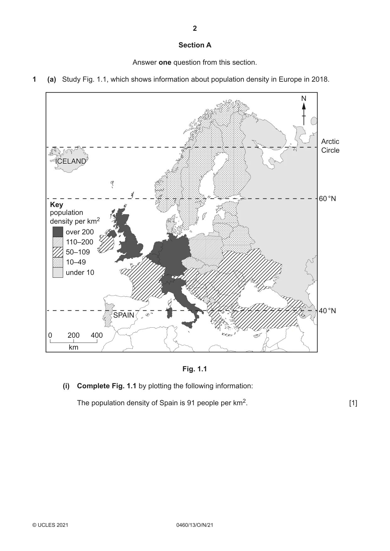
2 0460/13/O/N/21 © UCLES 2021 Section A Answer one question from this section. 1 (a) Study Fig. 1.1, which shows information about population density in Europe in 2018. SPAIN ICELAND Arctic Circle 60 °N 40 °N over 200 110–200 50–109 10–49 under 10 population density per km2 Key N 0 200 km 400 Fig. 1.1 (i) Complete Fig. 1.1 by plotting the following information: The population density of Spain is 91 people per km2. [1]
Question paper, page 3
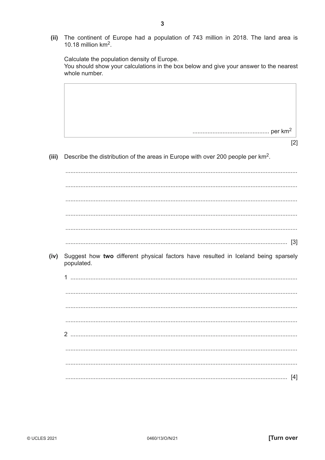
3 0460/13/O/N/21 © UCLES 2021 [Turn over (ii) The continent of Europe had a population of 743 million in 2018. The land area is 10.18 million km2. Calculate the population density of Europe. You should show your calculations in the box below and give your answer to the nearest whole number. … per km2 [2] (iii) Describe the distribution of the areas in Europe with over 200 people per km2. … … … … … … [3] (iv) Suggest how two different physical factors have resulted in Iceland being sparsely populated. 1 … … … … 2 … … … … [4]
Question paper, page 4
4 0460/13/O/N/21 © UCLES 2021 (b) Study Fig. 1.2 (Insert), which is a photograph taken in Amman, the capital city of Jordan. (i) Give three pieces of evidence from Fig. 1.2 which suggest that Amman is densely populated. 1 … … 2 … … 3 … … [3] (ii) Describe the problems experienced by people living in densely populated cities, such as Amman. … … … … … … … … … … [5]
Question paper, page 5
5 0460/13/O/N/21 © UCLES 2021 [Turn over (c) For a named country you have studied, explain the causes of overpopulation. Name of country … … … … … … … … … … … … … … … … … … … … … … … … … … [7] [Total: 25]
Question paper, page 6
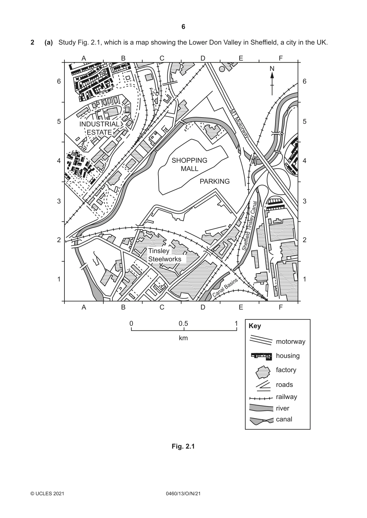
6 0460/13/O/N/21 © UCLES 2021 2 (a) Study Fig. 2.1, which is a map showing the Lower Don Valley in Sheffield, a city in the UK. A 1 2 3 4 5 6 1 2 3 4 5 6 B C 0 0.5 km 1 D E F A B C D E F N motorway Key housing factory roads railway river canal SHOPPING MALL PARKING Tinsley Steelworks INDUSTRIAL ESTATE Canal Basins Sheffield Tinsley Canal M1 Motorw ay Fig. 2.1
Question paper, page 7
7 0460/13/O/N/21 © UCLES 2021 [Turn over (i) Which urban zone is shown in Fig. 2.1? Tick (✓) your answer in the table below. tick (✓) Central Business District (CBD) high cost housing area inner city area with mixed land use outer suburban residential area [1] (ii) Identify the main land use in the following grid squares: A6 … F2. … [2] (iii) Using evidence from Fig. 2.1 only, state three different forms of transport which may have attracted manufacturing industry to the area shown. 1 … 2 … 3 … [3] (iv) The shopping mall in grid square D4 in Fig. 2.1 was recently built on the site of a disused factory. Suggest reasons why some people were in favour of the building of this shopping mall whilst other people were against it. … … … … … … … … [4]
Question paper, page 8
8 0460/13/O/N/21 © UCLES 2021 (b) Study Fig. 2.2 (Insert), which is a photograph taken in the Central Business District (CBD) of Shanghai, a city in China. (i) Using Fig. 2.2 only, describe three characteristics of the CBD of Shanghai. 1 … … 2 … … 3 … … [3] (ii) Give reasons why parts of the CBD of many cities are being redeveloped. … … … … … … … … … … … [5]
Question paper, page 9
9 0460/13/O/N/21 © UCLES 2021 [Turn over (c) For a named urban area you have studied, describe the types of pollution which occur and explain their causes. Name of urban area … … … … … … … … … … … … … … … … … … … … … … … … … … [7] [Total: 25]
Question paper, page 10
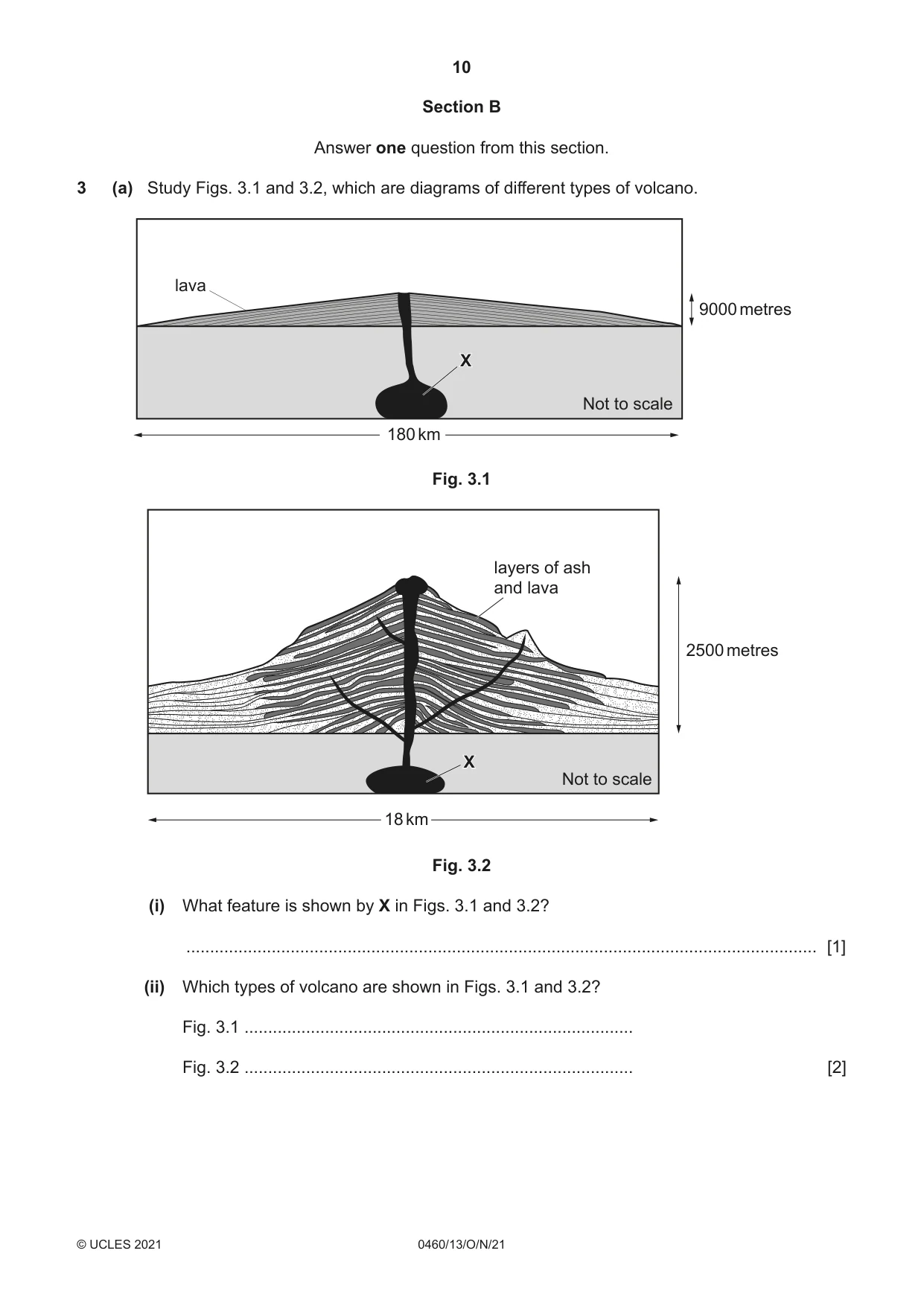
10 0460/13/O/N/21 © UCLES 2021 Section B Answer one question from this section. 3 (a) Study Figs. 3.1 and 3.2, which are diagrams of different types of volcano. 180 km 9000 metres Not to scale X lava Fig. 3.1 18 km 2500 metres Not to scale X layers of ash and lava Fig. 3.2 (i) What feature is shown by X in Figs. 3.1 and 3.2? … [1] (ii) Which types of volcano are shown in Figs. 3.1 and 3.2? Fig. 3.1 … Fig. 3.2 … [2]
Question paper, page 11
11 0460/13/O/N/21 © UCLES 2021 [Turn over (iii) Using Figs. 3.1 and 3.2 only, describe three differences between the volcanoes shown. 1 … … 2 … … 3 … … [3] (iv) Describe the benefits of living close to a volcano. … … … … … … … … [4]
Question paper, page 12
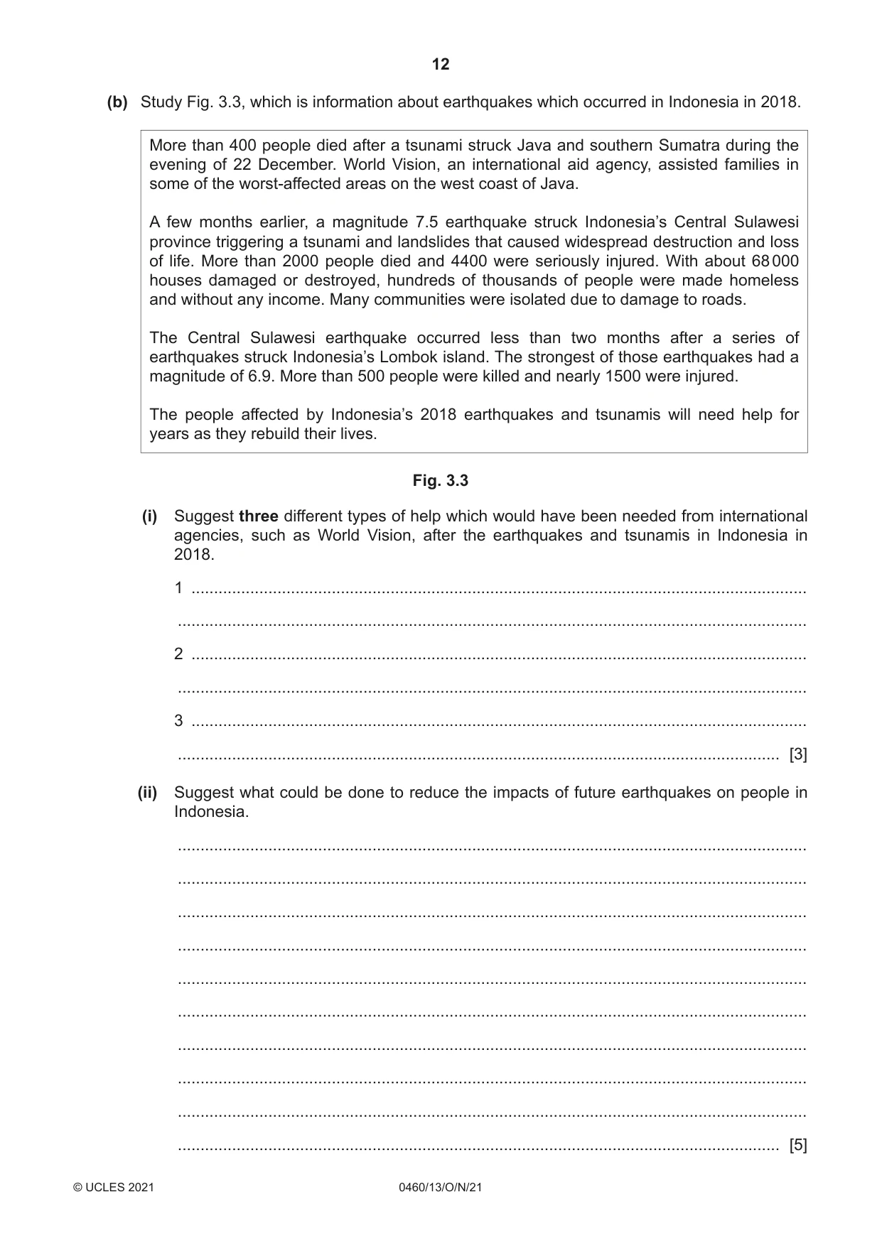
12 0460/13/O/N/21 © UCLES 2021 (b) Study Fig. 3.3, which is information about earthquakes which occurred in Indonesia in 2018. More than 400 people died after a tsunami struck Java and southern Sumatra during the evening of 22 December. World Vision, an international aid agency, assisted families in some of the worst-affected areas on the west coast of Java. A few months earlier, a magnitude 7.5 earthquake struck Indonesia’s Central Sulawesi province triggering a tsunami and landslides that caused widespread destruction and loss of life. More than 2000 people died and 4400 were seriously injured. With about 68 000 houses damaged or destroyed, hundreds of thousands of people were made homeless and without any income. Many communities were isolated due to damage to roads. The Central Sulawesi earthquake occurred less than two months after a series of earthquakes struck Indonesia’s Lombok island. The strongest of those earthquakes had a magnitude of 6.9. More than 500 people were killed and nearly 1500 were injured. The people affected by Indonesia’s 2018 earthquakes and tsunamis will need help for years as they rebuild their lives. Fig. 3.3 (i) Suggest three different types of help which would have been needed from international agencies, such as World Vision, after the earthquakes and tsunamis in Indonesia in 2018. 1 … … 2 … … 3 … … [3] (ii) Suggest what could be done to reduce the impacts of future earthquakes on people in Indonesia. … … … … … … … … … … [5]
Question paper, page 13
13 0460/13/O/N/21 © UCLES 2021 [Turn over (c) Explain the causes of an eruption of a named volcano you have studied. Name of volcano … … … … … … … … … … … … … … … … … … … … … … … … … … [7] [Total: 25]
Question paper, page 14
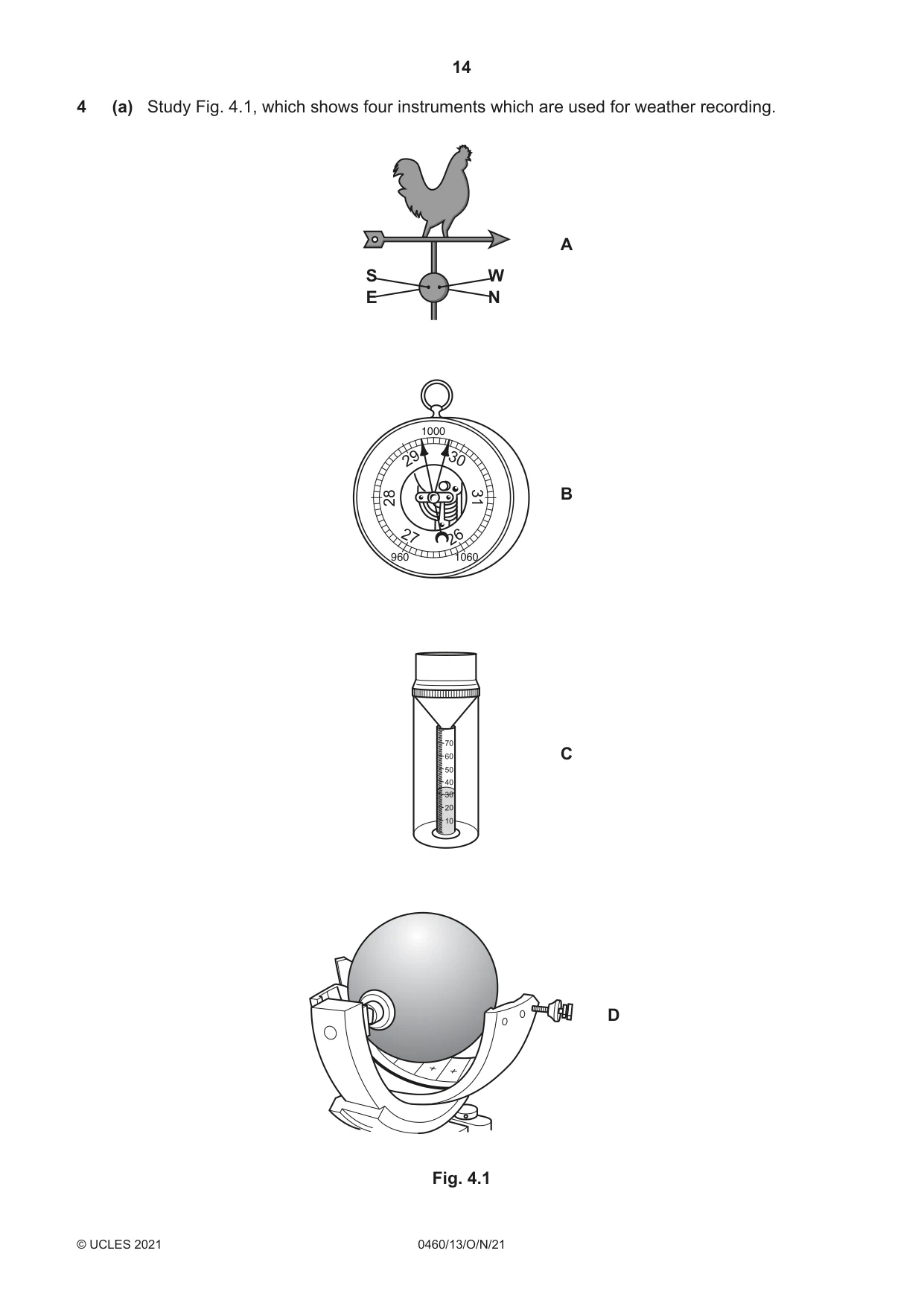
14 0460/13/O/N/21 © UCLES 2021 4 (a) Study Fig. 4.1, which shows four instruments which are used for weather recording. S W E N 27 30 26 29 28 31 10 20 30 40 50 60 70 A B C D 1000 960 1060 Fig. 4.1
Question paper, page 15
15 0460/13/O/N/21 © UCLES 2021 [Turn over (i) Which weather instrument shown in Fig. 4.1 is kept inside a Stevenson Screen? Circle your answer. A B C D [1] (ii) Identify (using the letters A, B, C or D) the two weather instruments shown in Fig. 4.1 which measure the following weather data: Atmospheric pressure … Precipitation. … [2] (iii) Draw arrows to match the names of the weather instruments A, B, C and D with their names in the table below. instrument A barometer instrument B rain gauge instrument C sunshine recorder instrument D wind vane [3] (iv) Describe and explain the ideal location for a wind vane at a weather station. … … … … … … … … [4]
Question paper, page 16
16 0460/13/O/N/21 © UCLES 2021 (b) Study Fig. 4.2 (Insert), which is a photograph showing different types of clouds. (i) Using Fig. 4.2: identify the type of cloud at X … estimate the amount of cloud cover … oktas describe one feature of the cloud type shown at X. … … [3] (ii) Explain how observations of cloud type and cover can be made and used to compare two different months. … … … … … … … … … … [5]
Question paper, page 17
17 0460/13/O/N/21 © UCLES 2021 [Turn over (c) Explain how a named river you have studied is managed to reduce the impacts of flooding. Name of river … … … … … … … … … … … … … … … … … … … … … … … … … … [7] [Total: 25]
Question paper, page 18
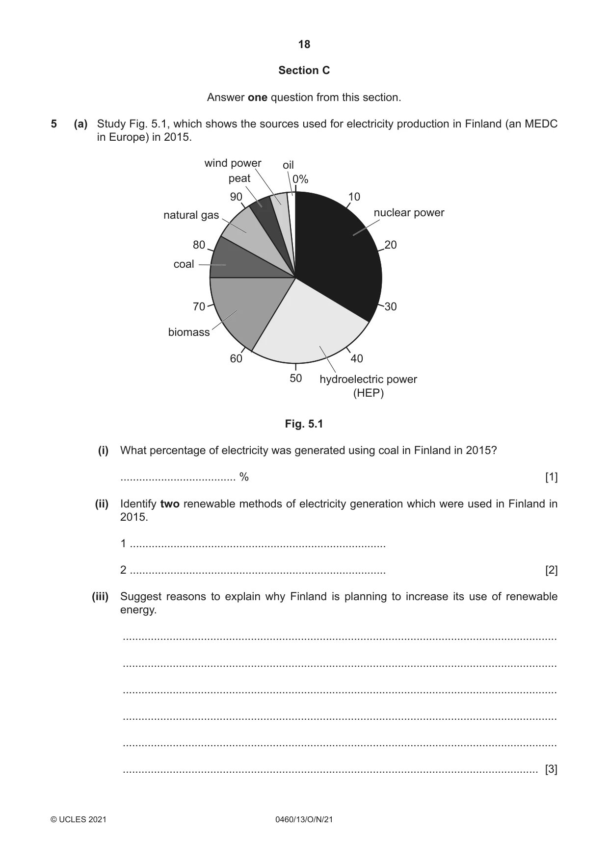
18 0460/13/O/N/21 © UCLES 2021 Section C Answer one question from this section. 5 (a) Study Fig. 5.1, which shows the sources used for electricity production in Finland (an MEDC in Europe) in 2015. 0% 50 10 nuclear power hydroelectric power (HEP) biomass coal natural gas peat wind power oil 20 30 40 90 80 70 60 Fig. 5.1 (i) What percentage of electricity was generated using coal in Finland in 2015? … % [1] (ii) Identify two renewable methods of electricity generation which were used in Finland in 2015. 1 … 2 … [2] (iii) Suggest reasons to explain why Finland is planning to increase its use of renewable energy. … … … … … … [3]
Question paper, page 19
19 0460/13/O/N/21 © UCLES 2021 [Turn over (iv) Give two advantages and two disadvantages of using nuclear power to generate electricity. Advantage 1 … … Advantage 2 … … Disadvantage 1 … … Disadvantage 2 … … [4]
Question paper, page 20
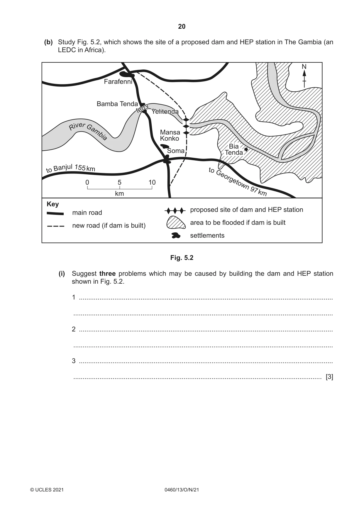
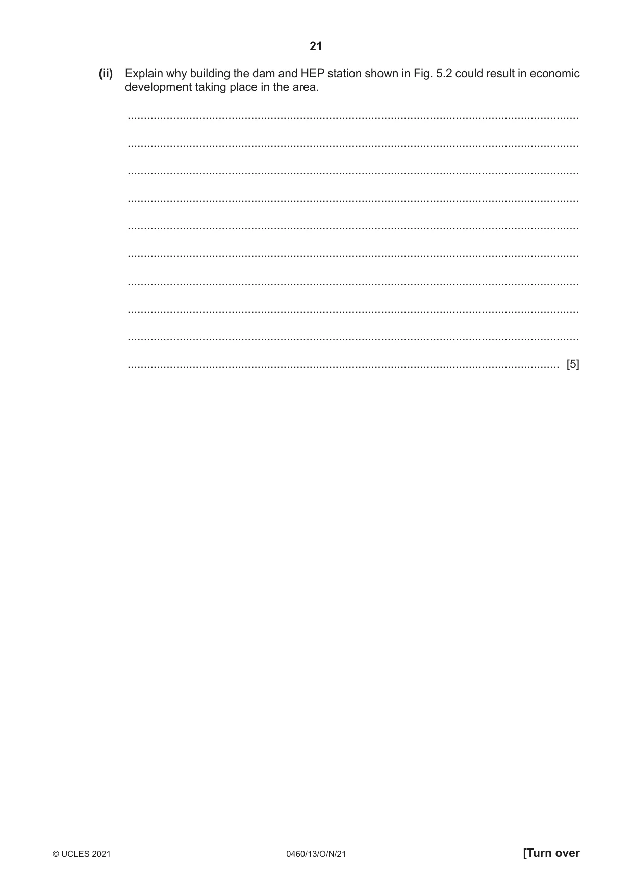
20 0460/13/O/N/21 © UCLES 2021 (b) Study Fig. 5.2, which shows the site of a proposed dam and HEP station in The Gambia (an LEDC in Africa). Farafenni Bamba Tenda Mansa Konko Yelitenda Bia Tenda Soma ferry to B an ju l 155 k m R i v e r G a m bia t o Geo rgetow n 9 7 k m 0 5 km 10 N main road new road (if dam is built) Key proposed site of dam and HEP station area to be flooded if dam is built settlements Fig. 5.2 (i) Suggest three problems which may be caused by building the dam and HEP station shown in Fig. 5.2. 1 … … 2 … … 3 … … [3]
Question paper, page 21
21 0460/13/O/N/21 © UCLES 2021 [Turn over (ii) Explain why building the dam and HEP station shown in Fig. 5.2 could result in economic development taking place in the area. … … … … … … … … … … [5]
Question paper, page 22
22 0460/13/O/N/21 © UCLES 2021 (c) For a named country or area you have studied, explain how sufficient water is supplied for domestic use. Name of country or area … … … … … … … … … … … … … … … … … … … … … … … … … … [7] [Total: 25]
Question paper, page 23
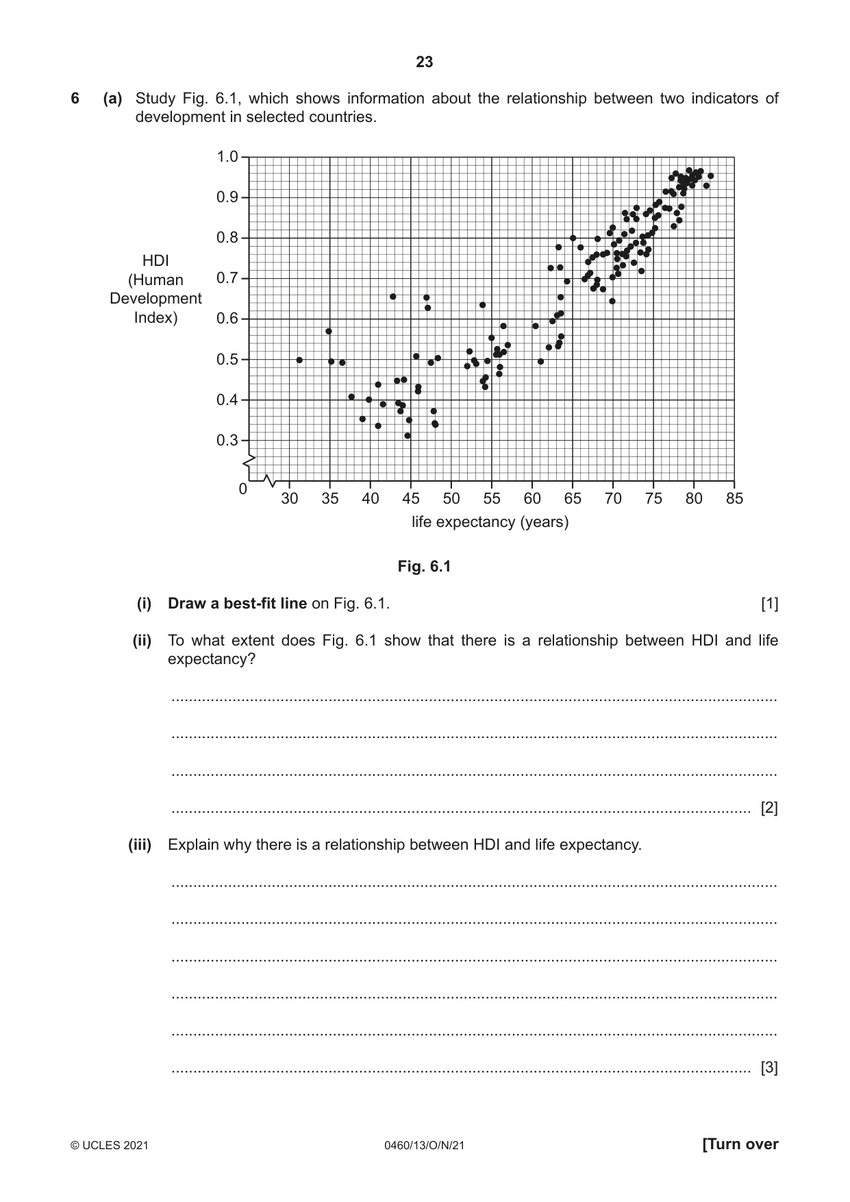
23 0460/13/O/N/21 © UCLES 2021 [Turn over 6 (a) Study Fig. 6.1, which shows information about the relationship between two indicators of development in selected countries. life expectancy (years) HDI (Human Development Index) 35 45 55 65 75 85 30 0 40 50 60 70 80 0.4 0.6 0.8 1.0 0.3 0.5 0.7 0.9 Fig. 6.1 (i) Draw a best-fit line on Fig. 6.1. [1] (ii) To what extent does Fig. 6.1 show that there is a relationship between HDI and life expectancy? … … … … [2] (iii) Explain why there is a relationship between HDI and life expectancy. … … … … … … [3]
Question paper, page 24
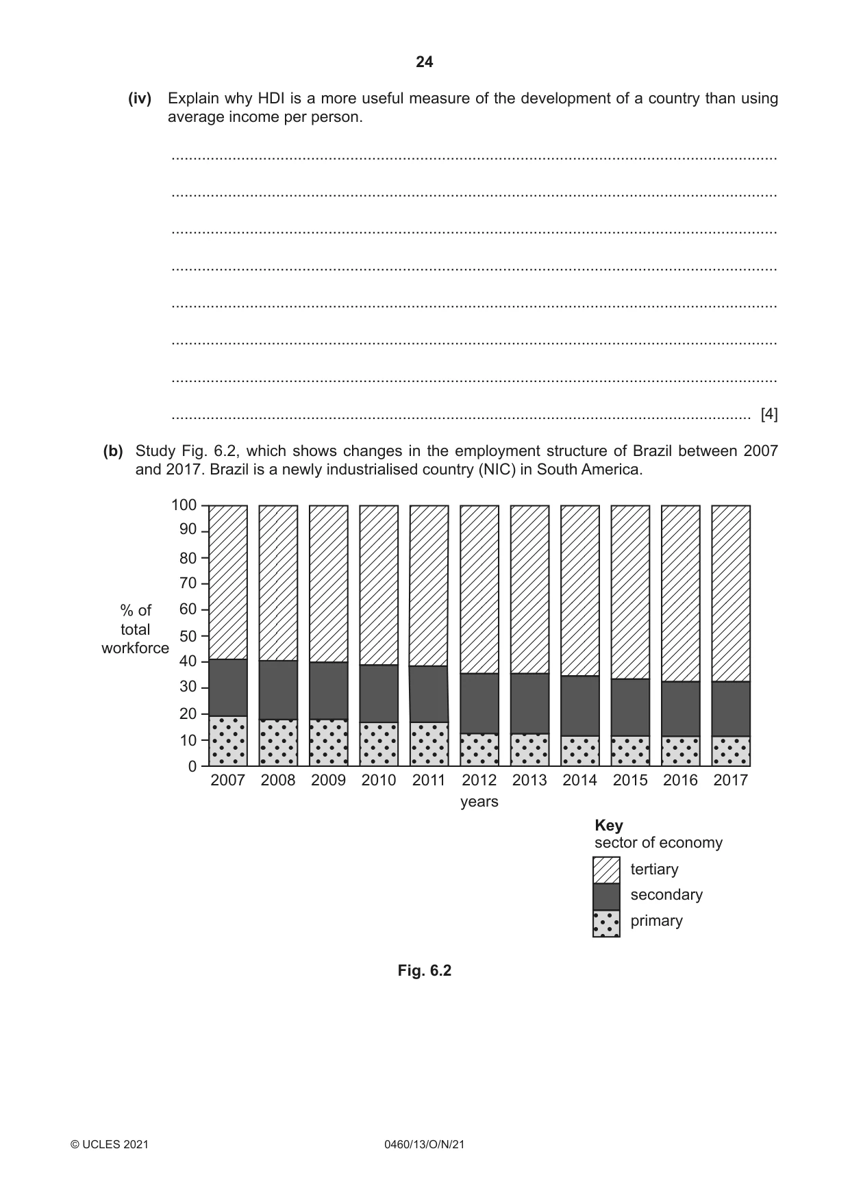
24 0460/13/O/N/21 © UCLES 2021 (iv) Explain why HDI is a more useful measure of the development of a country than using average income per person. … … … … … … … … [4] (b) Study Fig. 6.2, which shows changes in the employment structure of Brazil between 2007 and 2017. Brazil is a newly industrialised country (NIC) in South America. 100 90 80 70 60 50 % of total workforce 40 30 20 10 0 2007 2008 2009 2010 2011 2012 years 2013 2014 2015 2016 2017 tertiary secondary primary sector of economy Key Fig. 6.2
Question paper, page 25
25 0460/13/O/N/21 © UCLES 2021 [Turn over (i) Using Fig. 6.2 only, describe the changes in the employment structure of Brazil between 2007 and 2017. You should use statistics in your answer. … … … … … … [3] (ii) Explain why the employment structure of a country changes as it develops. … … … … … … … … … … [5]
Question paper, page 26
26 0460/13/O/N/21 © UCLES 2021 (c) Describe the effects of global warming. You should refer to named areas affected. Name of areas … … … … … … … … … … … … … … … … … … … … … … … … … … [7] [Total: 25]
Question paper, page 27
27 0460/13/O/N/21 © UCLES 2021 Additional Pages If you use the following lined pages to complete the answer(s) to any question(s), the question number(s) must be clearly shown. … … … … … … … … … … … … … … … … … … … … … … … … … …
Question paper, page 28
28 0460/13/O/N/21 © UCLES 2021 … … … … … … … … … … … … … … … … … … … … … … The boundaries and names shown, the designations used and the presentation of material on any maps contained in this question paper/insert do not imply official endorsement or acceptance by Cambridge Assessment International Education concerning the legal status of any country, territory, or area or any of its authorities, or of the delimitation of its frontiers or boundaries. Permission to reproduce items where third-party owned material protected by copyright is included has been sought and cleared where possible. Every reasonable effort has been made by the publisher (UCLES) to trace copyright holders, but if any items requiring clearance have unwittingly been included, the publisher will be pleased to make amends at the earliest possible opportunity. To avoid the issue of disclosure of answer-related information to candidates, all copyright acknowledgements are reproduced online in the Cambridge Assessment International Education Copyright Acknowledgements Booklet. This is produced for each series of examinations and is freely available to download at www.cambridgeinternational.org after the live examination series. Cambridge Assessment International Education is part of the Cambridge Assessment Group. Cambridge Assessment is the brand name of the University of Cambridge Local Examinations Syndicate (UCLES), which itself is a department of the University of Cambridge.
Mark scheme, page 1
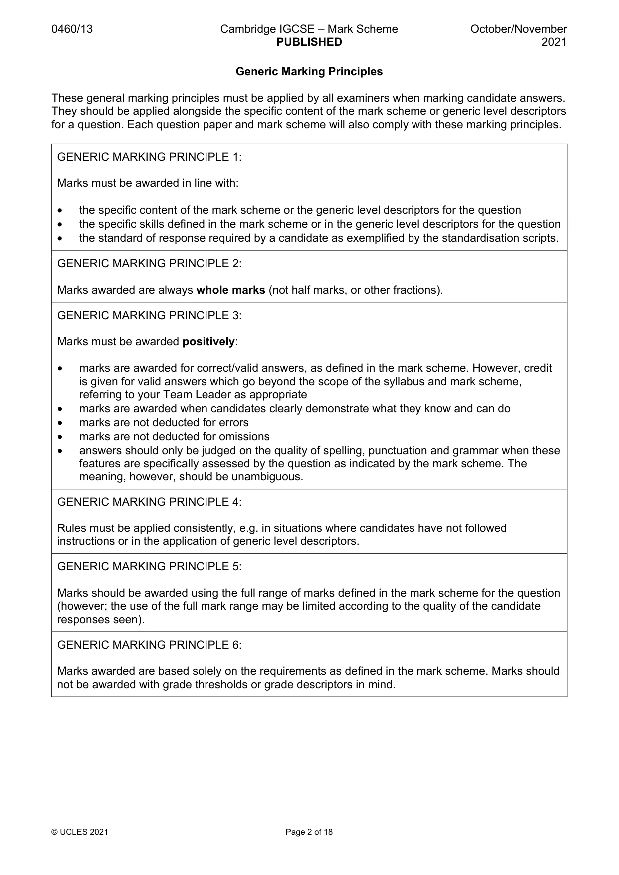
This document consists of 18 printed pages. © UCLES 2021 [Turn over Cambridge IGCSE™ GEOGRAPHY 0460/13 Paper 1 October/November 2021 MARK SCHEME Maximum Mark: 75 Published This mark scheme is published as an aid to teachers and candidates, to indicate the requirements of the examination. It shows the basis on which Examiners were instructed to award marks. It does not indicate the details of the discussions that took place at an Examiners’ meeting before marking began, which would have considered the acceptability of alternative answers. Mark schemes should be read in conjunction with the question paper and the Principal Examiner Report for Teachers. Cambridge International will not enter into discussions about these mark schemes. Cambridge International is publishing the mark schemes for the October/November 2021 series for most Cambridge IGCSE™, Cambridge International A and AS Level components and some Cambridge O Level components.
Mark scheme, page 2
0460/13 Cambridge IGCSE – Mark Scheme PUBLISHED October/November 2021 © UCLES 2021 Page 2 of 18 Generic Marking Principles These general marking principles must be applied by all examiners when marking candidate answers. They should be applied alongside the specific content of the mark scheme or generic level descriptors for a question. Each question paper and mark scheme will also comply with these marking principles. GENERIC MARKING PRINCIPLE 1: Marks must be awarded in line with: • the specific content of the mark scheme or the generic level descriptors for the question • the specific skills defined in the mark scheme or in the generic level descriptors for the question • the standard of response required by a candidate as exemplified by the standardisation scripts. GENERIC MARKING PRINCIPLE 2: Marks awarded are always whole marks (not half marks, or other fractions). GENERIC MARKING PRINCIPLE 3: Marks must be awarded positively: • marks are awarded for correct/valid answers, as defined in the mark scheme. However, credit is given for valid answers which go beyond the scope of the syllabus and mark scheme, referring to your Team Leader as appropriate • marks are awarded when candidates clearly demonstrate what they know and can do • marks are not deducted for errors • marks are not deducted for omissions • answers should only be judged on the quality of spelling, punctuation and grammar when these features are specifically assessed by the question as indicated by the mark scheme. The meaning, however, should be unambiguous. GENERIC MARKING PRINCIPLE 4: Rules must be applied consistently, e.g. in situations where candidates have not followed instructions or in the application of generic level descriptors. GENERIC MARKING PRINCIPLE 5: Marks should be awarded using the full range of marks defined in the mark scheme for the question (however; the use of the full mark range may be limited according to the quality of the candidate responses seen). GENERIC MARKING PRINCIPLE 6: Marks awarded are based solely on the requirements as defined in the mark scheme. Marks should not be awarded with grade thresholds or grade descriptors in mind.
Mark scheme, page 3
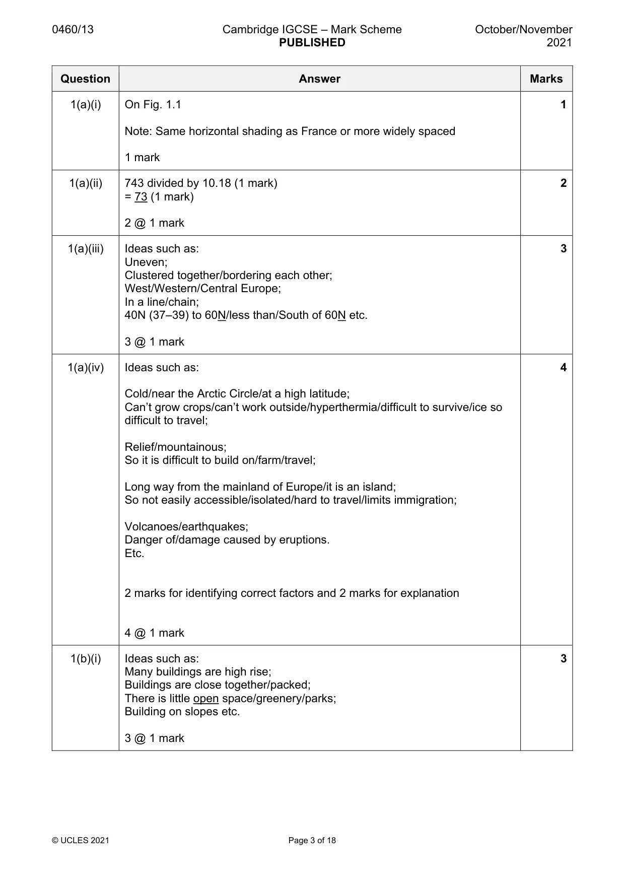
0460/13 Cambridge IGCSE – Mark Scheme PUBLISHED October/November 2021 © UCLES 2021 Page 3 of 18 Question Answer Marks 1(a)(i) On Fig. 1.1 Note: Same horizontal shading as France or more widely spaced 1 mark 1 1(a)(ii) 743 divided by 10.18 (1 mark) = 73 (1 mark) 2 @ 1 mark 2 1(a)(iii) Ideas such as: Uneven; Clustered together/bordering each other; West/Western/Central Europe; In a line/chain; 40N (37–39) to 60N/less than/South of 60N etc. 3 @ 1 mark 3 1(a)(iv) Ideas such as: Cold/near the Arctic Circle/at a high latitude; Can’t grow crops/can’t work outside/hyperthermia/difficult to survive/ice so difficult to travel; Relief/mountainous; So it is difficult to build on/farm/travel; Long way from the mainland of Europe/it is an island; So not easily accessible/isolated/hard to travel/limits immigration; Volcanoes/earthquakes; Danger of/damage caused by eruptions. Etc. 2 marks for identifying correct factors and 2 marks for explanation 4 @ 1 mark 4 1(b)(i) Ideas such as: Many buildings are high rise; Buildings are close together/packed; There is little open space/greenery/parks; Building on slopes etc. 3 @ 1 mark 3
Mark scheme, page 4
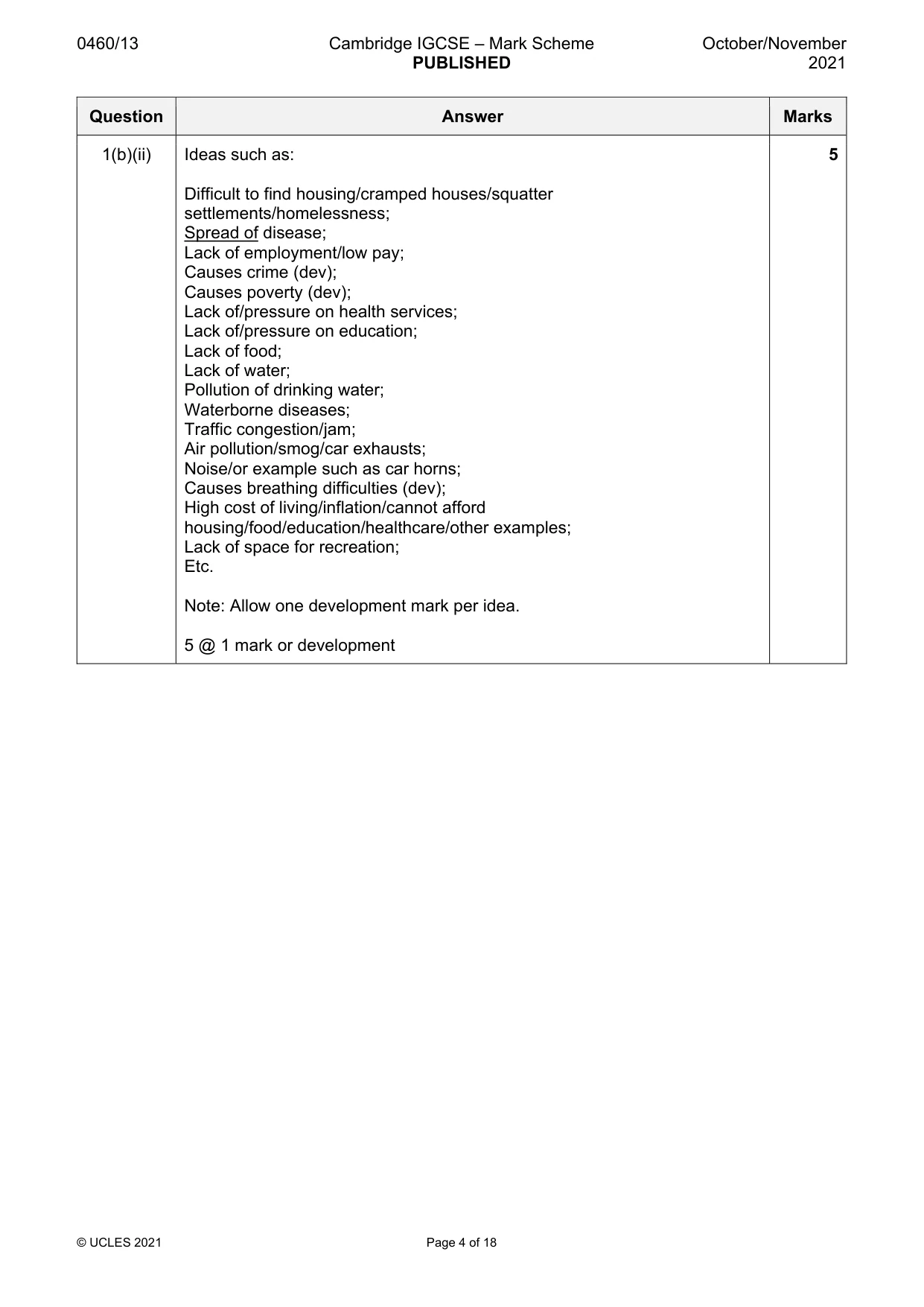
0460/13 Cambridge IGCSE – Mark Scheme PUBLISHED October/November 2021 © UCLES 2021 Page 4 of 18 Question Answer Marks 1(b)(ii) Ideas such as: Difficult to find housing/cramped houses/squatter settlements/homelessness; Spread of disease; Lack of employment/low pay; Causes crime (dev); Causes poverty (dev); Lack of/pressure on health services; Lack of/pressure on education; Lack of food; Lack of water; Pollution of drinking water; Waterborne diseases; Traffic congestion/jam; Air pollution/smog/car exhausts; Noise/or example such as car horns; Causes breathing difficulties (dev); High cost of living/inflation/cannot afford housing/food/education/healthcare/other examples; Lack of space for recreation; Etc. Note: Allow one development mark per idea. 5 @ 1 mark or development 5
Mark scheme, page 5
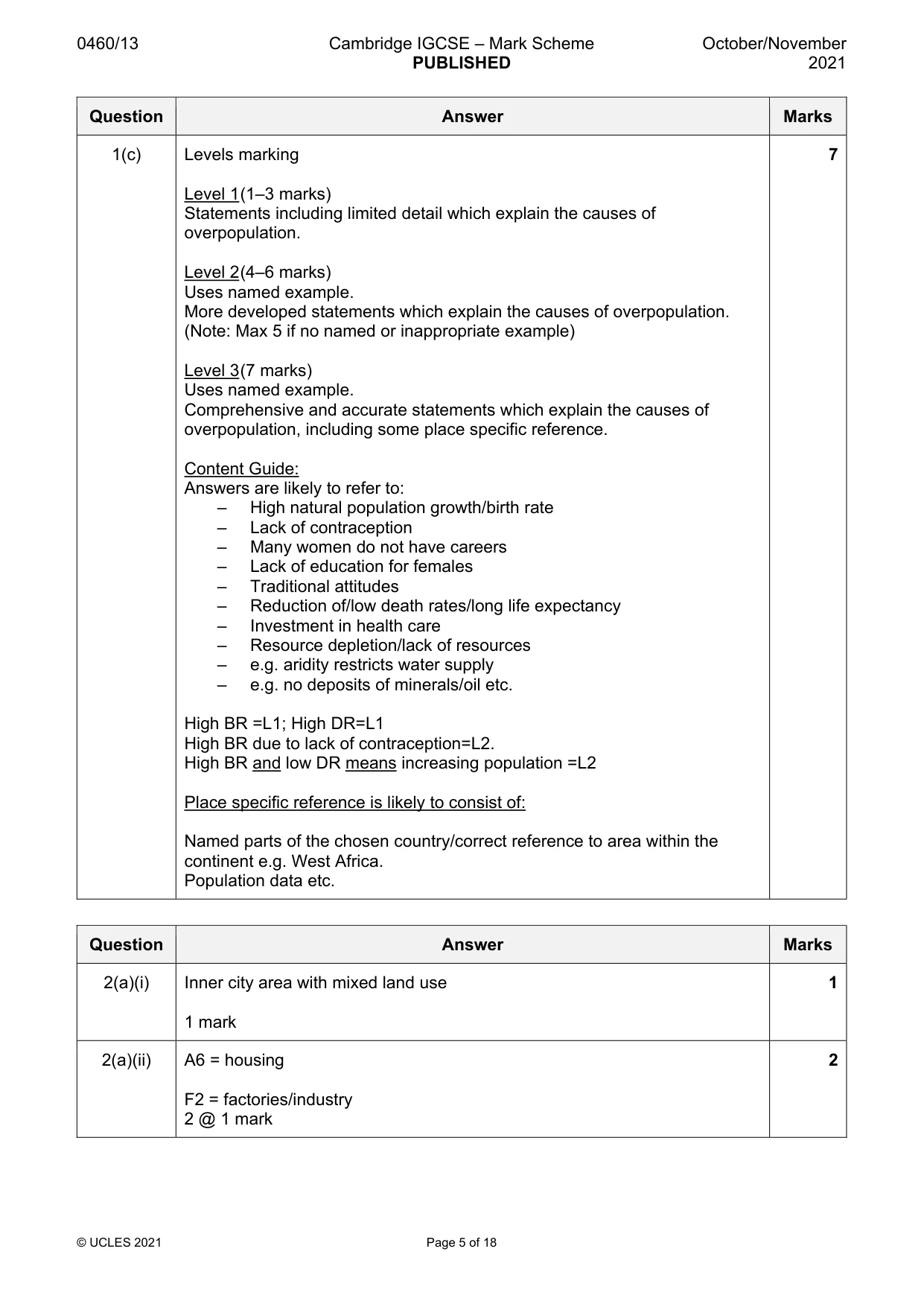
0460/13 Cambridge IGCSE – Mark Scheme PUBLISHED October/November 2021 © UCLES 2021 Page 5 of 18 Question Answer Marks 1(c) Levels marking Level 1 (1–3 marks) Statements including limited detail which explain the causes of overpopulation. Level 2 (4–6 marks) Uses named example. More developed statements which explain the causes of overpopulation. (Note: Max 5 if no named or inappropriate example) Level 3 (7 marks) Uses named example. Comprehensive and accurate statements which explain the causes of overpopulation, including some place specific reference. Content Guide: Answers are likely to refer to: – High natural population growth/birth rate – Lack of contraception – Many women do not have careers – Lack of education for females – Traditional attitudes – Reduction of/low death rates/long life expectancy – Investment in health care – Resource depletion/lack of resources – e.g. aridity restricts water supply – e.g. no deposits of minerals/oil etc. High BR =L1; High DR=L1 High BR due to lack of contraception=L2. High BR and low DR means increasing population =L2 Place specific reference is likely to consist of: Named parts of the chosen country/correct reference to area within the continent e.g. West Africa. Population data etc. 7 Question Answer Marks 2(a)(i) Inner city area with mixed land use 1 mark 1 2(a)(ii) A6 = housing F2 = factories/industry 2 @ 1 mark 2
Mark scheme, page 6
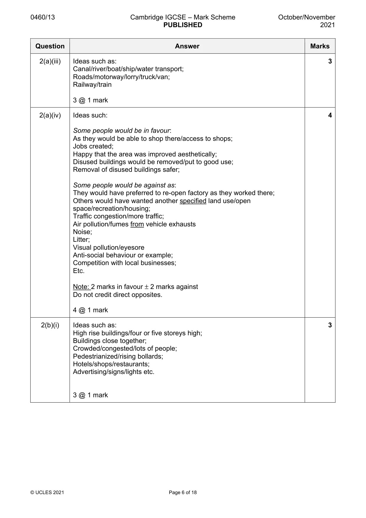
0460/13 Cambridge IGCSE – Mark Scheme PUBLISHED October/November 2021 © UCLES 2021 Page 6 of 18 Question Answer Marks 2(a)(iii) Ideas such as: Canal/river/boat/ship/water transport; Roads/motorway/lorry/truck/van; Railway/train 3 @ 1 mark 3 2(a)(iv) Ideas such: Some people would be in favour: As they would be able to shop there/access to shops; Jobs created; Happy that the area was improved aesthetically; Disused buildings would be removed/put to good use; Removal of disused buildings safer; Some people would be against as: They would have preferred to re-open factory as they worked there; Others would have wanted another specified land use/open space/recreation/housing; Traffic congestion/more traffic; Air pollution/fumes from vehicle exhausts Noise; Litter; Visual pollution/eyesore Anti-social behaviour or example; Competition with local businesses; Etc. Note: 2 marks in favour ± 2 marks against Do not credit direct opposites. 4 @ 1 mark 4 2(b)(i) Ideas such as: High rise buildings/four or five storeys high; Buildings close together; Crowded/congested/lots of people; Pedestrianized/rising bollards; Hotels/shops/restaurants; Advertising/signs/lights etc. 3 @ 1 mark 3
Mark scheme, page 7
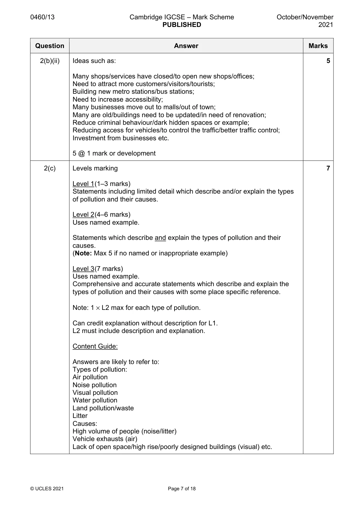
0460/13 Cambridge IGCSE – Mark Scheme PUBLISHED October/November 2021 © UCLES 2021 Page 7 of 18 Question Answer Marks 2(b)(ii) Ideas such as: Many shops/services have closed/to open new shops/offices; Need to attract more customers/visitors/tourists; Building new metro stations/bus stations; Need to increase accessibility; Many businesses move out to malls/out of town; Many are old/buildings need to be updated/in need of renovation; Reduce criminal behaviour/dark hidden spaces or example; Reducing access for vehicles/to control the traffic/better traffic control; Investment from businesses etc. 5 @ 1 mark or development 5 2(c) Levels marking Level 1 (1–3 marks) Statements including limited detail which describe and/or explain the types of pollution and their causes. Level 2 (4–6 marks) Uses named example. Statements which describe and explain the types of pollution and their causes. (Note: Max 5 if no named or inappropriate example) Level 3 (7 marks) Uses named example. Comprehensive and accurate statements which describe and explain the types of pollution and their causes with some place specific reference. Note: 1 × L2 max for each type of pollution. Can credit explanation without description for L1. L2 must include description and explanation. Content Guide: Answers are likely to refer to: Types of pollution: Air pollution Noise pollution Visual pollution Water pollution Land pollution/waste Litter Causes: High volume of people (noise/litter) Vehicle exhausts (air) Lack of open space/high rise/poorly designed buildings (visual) etc. 7
Mark scheme, page 8
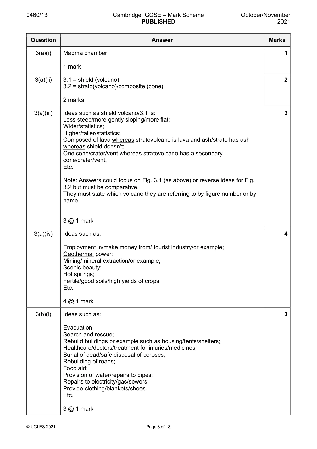
0460/13 Cambridge IGCSE – Mark Scheme PUBLISHED October/November 2021 © UCLES 2021 Page 8 of 18 Question Answer Marks 3(a)(i) Magma chamber 1 mark 1 3(a)(ii) 3.1 = shield (volcano) 3.2 = strato(volcano)/composite (cone) 2 marks 2 3(a)(iii) Ideas such as shield volcano/3.1 is: Less steep/more gently sloping/more flat; Wider/statistics; Higher/taller/statistics; Composed of lava whereas stratovolcano is lava and ash/strato has ash whereas shield doesn’t; One cone/crater/vent whereas stratovolcano has a secondary cone/crater/vent. Etc. Note: Answers could focus on Fig. 3.1 (as above) or reverse ideas for Fig. 3.2 but must be comparative. They must state which volcano they are referring to by figure number or by name. 3 @ 1 mark 3 3(a)(iv) Ideas such as: Employment in/make money from/ tourist industry/or example; Geothermal power; Mining/mineral extraction/or example; Scenic beauty; Hot springs; Fertile/good soils/high yields of crops. Etc. 4 @ 1 mark 4 3(b)(i) Ideas such as: Evacuation; Search and rescue; Rebuild buildings or example such as housing/tents/shelters; Healthcare/doctors/treatment for injuries/medicines; Burial of dead/safe disposal of corpses; Rebuilding of roads; Food aid; Provision of water/repairs to pipes; Repairs to electricity/gas/sewers; Provide clothing/blankets/shoes. Etc. 3 @ 1 mark 3
Mark scheme, page 9
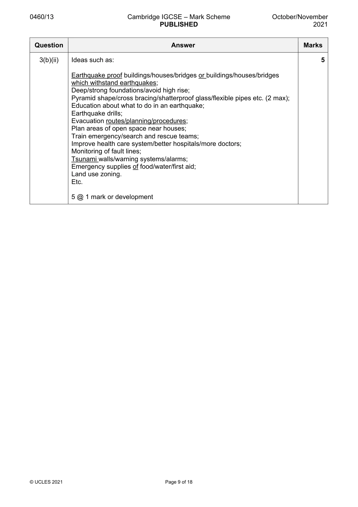
0460/13 Cambridge IGCSE – Mark Scheme PUBLISHED October/November 2021 © UCLES 2021 Page 9 of 18 Question Answer Marks 3(b)(ii) Ideas such as: Earthquake proof buildings/houses/bridges or buildings/houses/bridges which withstand earthquakes; Deep/strong foundations/avoid high rise; Pyramid shape/cross bracing/shatterproof glass/flexible pipes etc. (2 max); Education about what to do in an earthquake; Earthquake drills; Evacuation routes/planning/procedures; Plan areas of open space near houses; Train emergency/search and rescue teams; Improve health care system/better hospitals/more doctors; Monitoring of fault lines; Tsunami walls/warning systems/alarms; Emergency supplies of food/water/first aid; Land use zoning. Etc. 5 @ 1 mark or development 5
Mark scheme, page 10
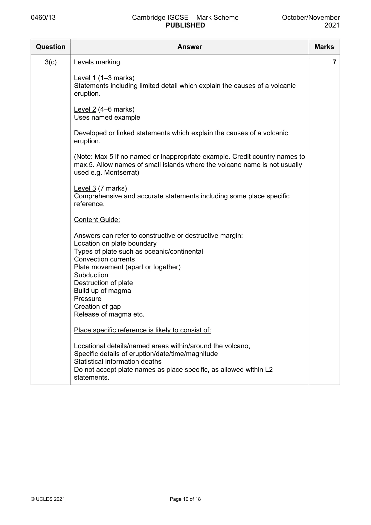
0460/13 Cambridge IGCSE – Mark Scheme PUBLISHED October/November 2021 © UCLES 2021 Page 10 of 18 Question Answer Marks 3(c) Levels marking Level 1 (1–3 marks) Statements including limited detail which explain the causes of a volcanic eruption. Level 2 (4–6 marks) Uses named example Developed or linked statements which explain the causes of a volcanic eruption. (Note: Max 5 if no named or inappropriate example. Credit country names to max.5. Allow names of small islands where the volcano name is not usually used e.g. Montserrat) Level 3 (7 marks) Comprehensive and accurate statements including some place specific reference. Content Guide: Answers can refer to constructive or destructive margin: Location on plate boundary Types of plate such as oceanic/continental Convection currents Plate movement (apart or together) Subduction Destruction of plate Build up of magma Pressure Creation of gap Release of magma etc. Place specific reference is likely to consist of: Locational details/named areas within/around the volcano, Specific details of eruption/date/time/magnitude Statistical information deaths Do not accept plate names as place specific, as allowed within L2 statements. 7
Mark scheme, page 11
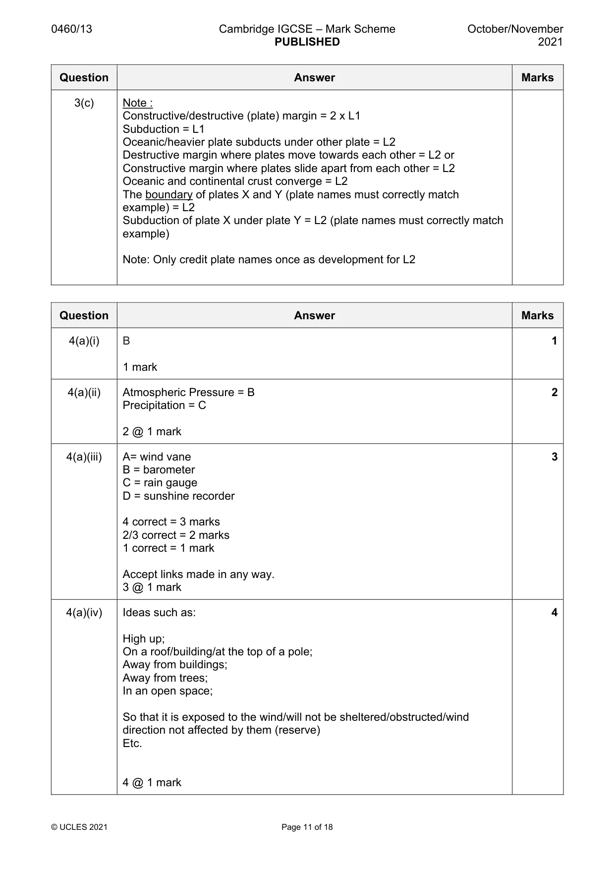
0460/13 Cambridge IGCSE – Mark Scheme PUBLISHED October/November 2021 © UCLES 2021 Page 11 of 18 Question Answer Marks 3(c) Note : Constructive/destructive (plate) margin = 2 x L1 Subduction = L1 Oceanic/heavier plate subducts under other plate = L2 Destructive margin where plates move towards each other = L2 or Constructive margin where plates slide apart from each other = L2 Oceanic and continental crust converge = L2 The boundary of plates X and Y (plate names must correctly match example) = L2 Subduction of plate X under plate Y = L2 (plate names must correctly match example) Note: Only credit plate names once as development for L2 Question Answer Marks 4(a)(i) B 1 mark 1 4(a)(ii) Atmospheric Pressure = B Precipitation = C 2 @ 1 mark 2 4(a)(iii) A= wind vane B = barometer C = rain gauge D = sunshine recorder 4 correct = 3 marks 2/3 correct = 2 marks 1 correct = 1 mark Accept links made in any way. 3 @ 1 mark 3 4(a)(iv) Ideas such as: High up; On a roof/building/at the top of a pole; Away from buildings; Away from trees; In an open space; So that it is exposed to the wind/will not be sheltered/obstructed/wind direction not affected by them (reserve) Etc. 4 @ 1 mark 4
Mark scheme, page 12
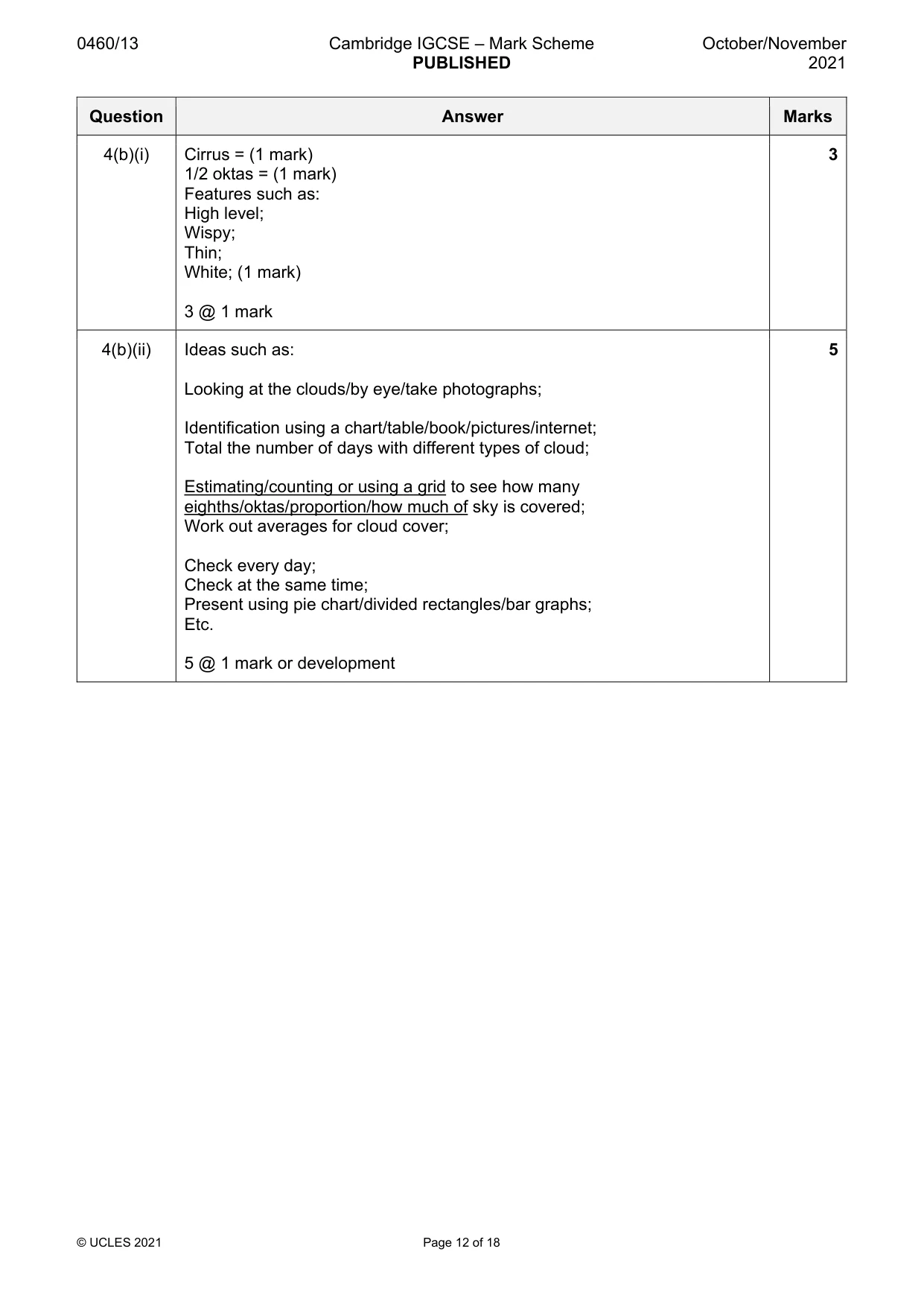
0460/13 Cambridge IGCSE – Mark Scheme PUBLISHED October/November 2021 © UCLES 2021 Page 12 of 18 Question Answer Marks 4(b)(i) Cirrus = (1 mark) 1/2 oktas = (1 mark) Features such as: High level; Wispy; Thin; White; (1 mark) 3 @ 1 mark 3 4(b)(ii) Ideas such as: Looking at the clouds/by eye/take photographs; Identification using a chart/table/book/pictures/internet; Total the number of days with different types of cloud; Estimating/counting or using a grid to see how many eighths/oktas/proportion/how much of sky is covered; Work out averages for cloud cover; Check every day; Check at the same time; Present using pie chart/divided rectangles/bar graphs; Etc. 5 @ 1 mark or development 5
Mark scheme, page 13
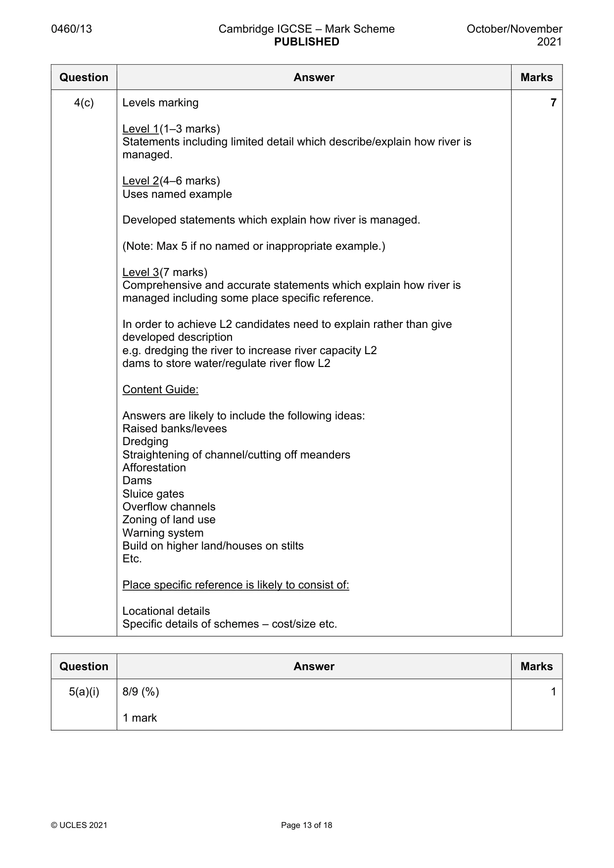
0460/13 Cambridge IGCSE – Mark Scheme PUBLISHED October/November 2021 © UCLES 2021 Page 13 of 18 Question Answer Marks 4(c) Levels marking Level 1 (1–3 marks) Statements including limited detail which describe/explain how river is managed. Level 2 (4–6 marks) Uses named example Developed statements which explain how river is managed. (Note: Max 5 if no named or inappropriate example.) Level 3 (7 marks) Comprehensive and accurate statements which explain how river is managed including some place specific reference. In order to achieve L2 candidates need to explain rather than give developed description e.g. dredging the river to increase river capacity L2 dams to store water/regulate river flow L2 Content Guide: Answers are likely to include the following ideas: Raised banks/levees Dredging Straightening of channel/cutting off meanders Afforestation Dams Sluice gates Overflow channels Zoning of land use Warning system Build on higher land/houses on stilts Etc. Place specific reference is likely to consist of: Locational details Specific details of schemes – cost/size etc. 7 Question Answer Marks 5(a)(i) 8/9 (%) 1 mark 1
Mark scheme, page 14
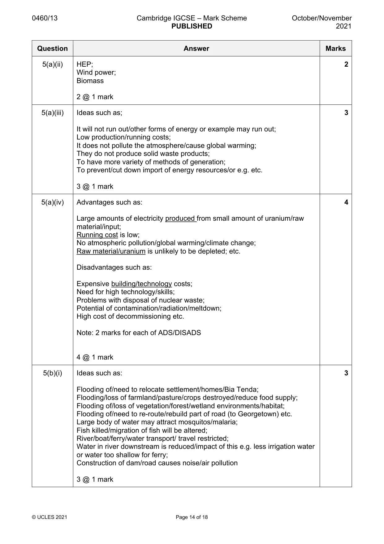
0460/13 Cambridge IGCSE – Mark Scheme PUBLISHED October/November 2021 © UCLES 2021 Page 14 of 18 Question Answer Marks 5(a)(ii) HEP; Wind power; Biomass 2 @ 1 mark 2 5(a)(iii) Ideas such as; It will not run out/other forms of energy or example may run out; Low production/running costs; It does not pollute the atmosphere/cause global warming; They do not produce solid waste products; To have more variety of methods of generation; To prevent/cut down import of energy resources/or e.g. etc. 3 @ 1 mark 3 5(a)(iv) Advantages such as: Large amounts of electricity produced from small amount of uranium/raw material/input; Running cost is low; No atmospheric pollution/global warming/climate change; Raw material/uranium is unlikely to be depleted; etc. Disadvantages such as: Expensive building/technology costs; Need for high technology/skills; Problems with disposal of nuclear waste; Potential of contamination/radiation/meltdown; High cost of decommissioning etc. Note: 2 marks for each of ADS/DISADS 4 @ 1 mark 4 5(b)(i) Ideas such as: Flooding of/need to relocate settlement/homes/Bia Tenda; Flooding/loss of farmland/pasture/crops destroyed/reduce food supply; Flooding of/loss of vegetation/forest/wetland environments/habitat; Flooding of/need to re-route/rebuild part of road (to Georgetown) etc. Large body of water may attract mosquitos/malaria; Fish killed/migration of fish will be altered; River/boat/ferry/water transport/ travel restricted; Water in river downstream is reduced/impact of this e.g. less irrigation water or water too shallow for ferry; Construction of dam/road causes noise/air pollution 3 @ 1 mark 3
Mark scheme, page 15
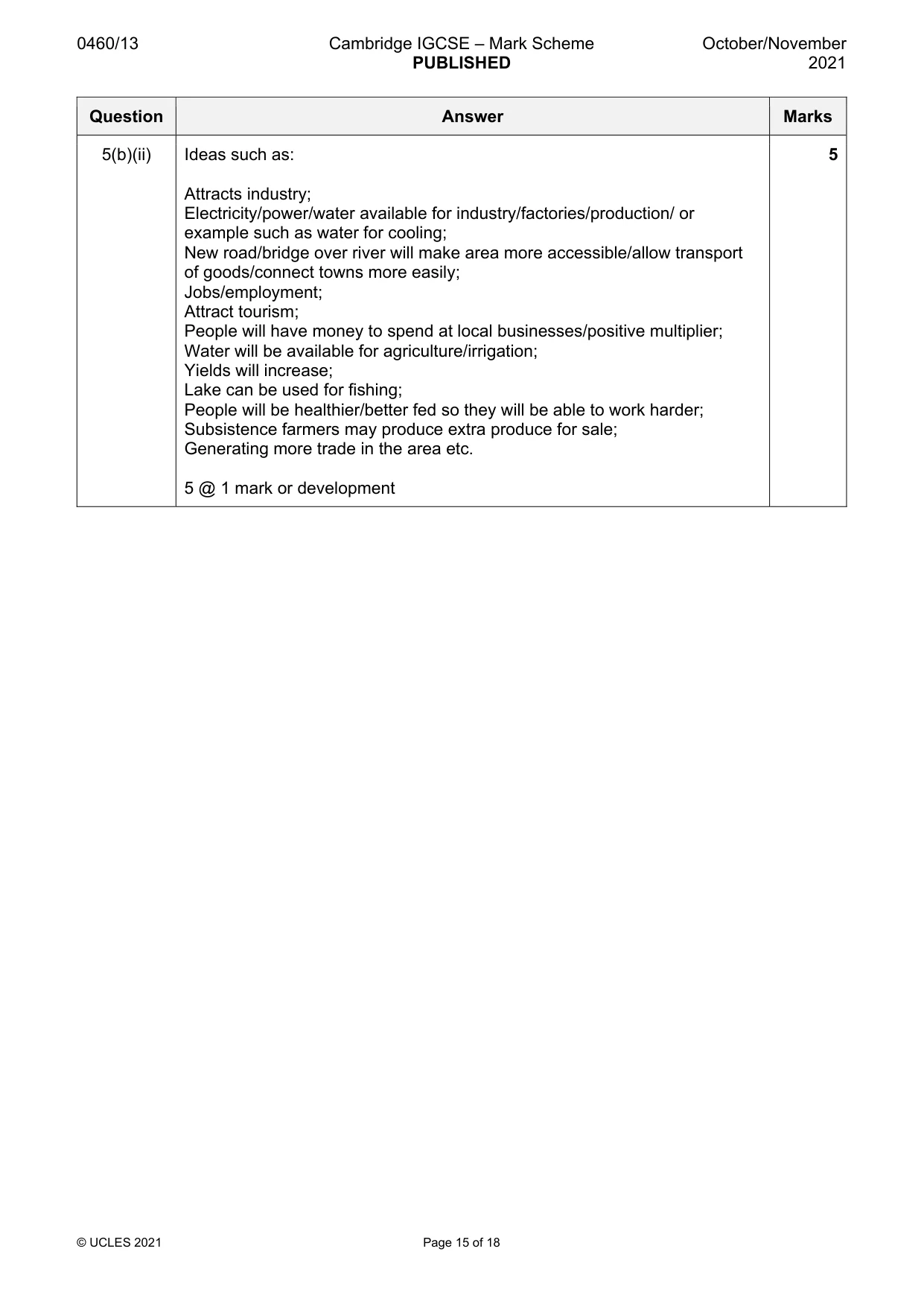
0460/13 Cambridge IGCSE – Mark Scheme PUBLISHED October/November 2021 © UCLES 2021 Page 15 of 18 Question Answer Marks 5(b)(ii) Ideas such as: Attracts industry; Electricity/power/water available for industry/factories/production/ or example such as water for cooling; New road/bridge over river will make area more accessible/allow transport of goods/connect towns more easily; Jobs/employment; Attract tourism; People will have money to spend at local businesses/positive multiplier; Water will be available for agriculture/irrigation; Yields will increase; Lake can be used for fishing; People will be healthier/better fed so they will be able to work harder; Subsistence farmers may produce extra produce for sale; Generating more trade in the area etc. 5 @ 1 mark or development 5
Mark scheme, page 16
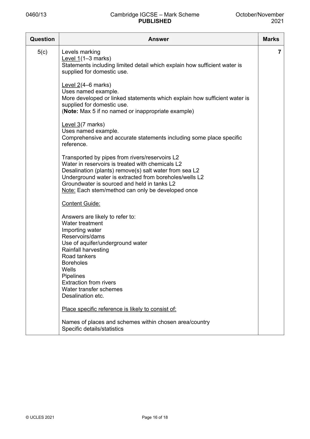
0460/13 Cambridge IGCSE – Mark Scheme PUBLISHED October/November 2021 © UCLES 2021 Page 16 of 18 Question Answer Marks 5(c) Levels marking Level 1 (1–3 marks) Statements including limited detail which explain how sufficient water is supplied for domestic use. Level 2 (4–6 marks) Uses named example. More developed or linked statements which explain how sufficient water is supplied for domestic use. (Note: Max 5 if no named or inappropriate example) Level 3 (7 marks) Uses named example. Comprehensive and accurate statements including some place specific reference. Transported by pipes from rivers/reservoirs L2 Water in reservoirs is treated with chemicals L2 Desalination (plants) remove(s) salt water from sea L2 Underground water is extracted from boreholes/wells L2 Groundwater is sourced and held in tanks L2 Note: Each stem/method can only be developed once Content Guide: Answers are likely to refer to: Water treatment Importing water Reservoirs/dams Use of aquifer/underground water Rainfall harvesting Road tankers Boreholes Wells Pipelines Extraction from rivers Water transfer schemes Desalination etc. Place specific reference is likely to consist of: Names of places and schemes within chosen area/country Specific details/statistics 7
Mark scheme, page 17
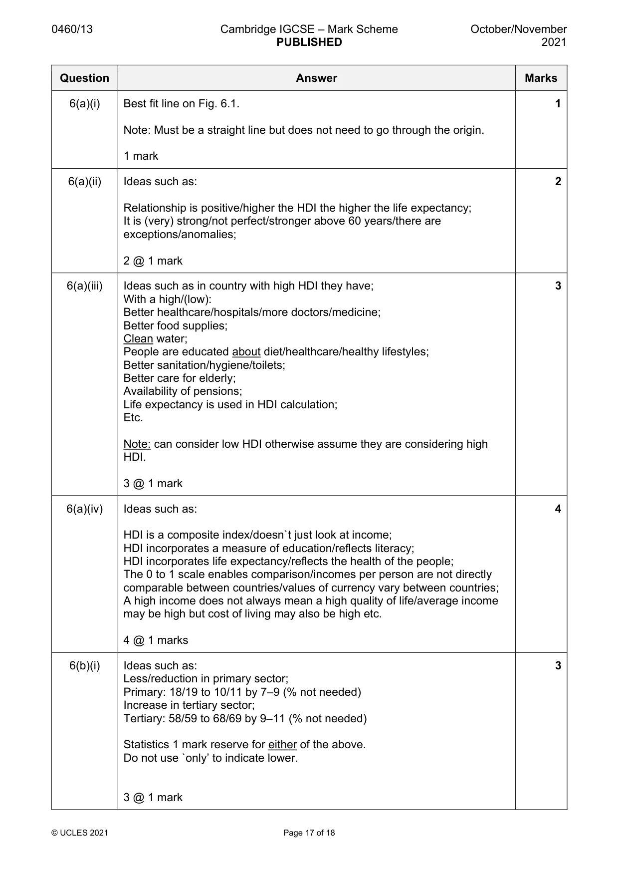
0460/13 Cambridge IGCSE – Mark Scheme PUBLISHED October/November 2021 © UCLES 2021 Page 17 of 18 Question Answer Marks 6(a)(i) Best fit line on Fig. 6.1. Note: Must be a straight line but does not need to go through the origin. 1 mark 1 6(a)(ii) Ideas such as: Relationship is positive/higher the HDI the higher the life expectancy; It is (very) strong/not perfect/stronger above 60 years/there are exceptions/anomalies; 2 @ 1 mark 2 6(a)(iii) Ideas such as in country with high HDI they have; With a high/(low): Better healthcare/hospitals/more doctors/medicine; Better food supplies; Clean water; People are educated about diet/healthcare/healthy lifestyles; Better sanitation/hygiene/toilets; Better care for elderly; Availability of pensions; Life expectancy is used in HDI calculation; Etc. Note: can consider low HDI otherwise assume they are considering high HDI. 3 @ 1 mark 3 6(a)(iv) Ideas such as: HDI is a composite index/doesn`t just look at income; HDI incorporates a measure of education/reflects literacy; HDI incorporates life expectancy/reflects the health of the people; The 0 to 1 scale enables comparison/incomes per person are not directly comparable between countries/values of currency vary between countries; A high income does not always mean a high quality of life/average income may be high but cost of living may also be high etc. 4 @ 1 marks 4 6(b)(i) Ideas such as: Less/reduction in primary sector; Primary: 18/19 to 10/11 by 7–9 (% not needed) Increase in tertiary sector; Tertiary: 58/59 to 68/69 by 9–11 (% not needed) Statistics 1 mark reserve for either of the above. Do not use `only’ to indicate lower. 3 @ 1 mark 3
Mark scheme, page 18
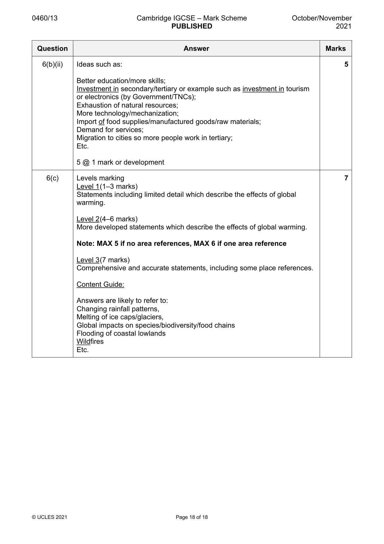
0460/13 Cambridge IGCSE – Mark Scheme PUBLISHED October/November 2021 © UCLES 2021 Page 18 of 18 Question Answer Marks 6(b)(ii) Ideas such as: Better education/more skills; Investment in secondary/tertiary or example such as investment in tourism or electronics (by Government/TNCs); Exhaustion of natural resources; More technology/mechanization; Import of food supplies/manufactured goods/raw materials; Demand for services; Migration to cities so more people work in tertiary; Etc. 5 @ 1 mark or development 5 6(c) Levels marking Level 1 (1–3 marks) Statements including limited detail which describe the effects of global warming. Level 2 (4–6 marks) More developed statements which describe the effects of global warming. Note: MAX 5 if no area references, MAX 6 if one area reference Level 3 (7 marks) Comprehensive and accurate statements, including some place references. Content Guide: Answers are likely to refer to: Changing rainfall patterns, Melting of ice caps/glaciers, Global impacts on species/biodiversity/food chains Flooding of coastal lowlands Wildfires Etc. 7
What you needed in this session
Cambridge’s own grade thresholds for 2021 Oct/Nov, Paper 1 · Variant 3. A higher threshold means an easier paper — the bar moves with how the cohort did.