Cambridge IGCSE Geography 0460 — 2021 Oct/Nov Paper 1 · Variant 2
0460/12/O/N/21 · 75 marks · ≈84 min
The question paper and its mark scheme, free to read here and free to download. This is Cambridge’s own paper, exactly as it was sat.
Question paper32 pages










Mark scheme18 pages
Answers below. Sit the paper first if you are practising.

Paper as text
Question paper, page 1
This document has 32 pages. Cambridge IGCSE™ DC (MS/CT) 199599/4 © UCLES 2021 [Turn over GEOGRAPHY 0460/12 Paper 1 Geographical Themes October/November 2021 1 hour 45 minutes You must answer on the question paper. You will need: Insert (enclosed) Calculator Ruler INSTRUCTIONS ● Answer three questions in total, one from each section. ● Use a black or dark blue pen. You may use an HB pencil for any diagrams or graphs. ● Write your name, centre number and candidate number in the boxes at the top of the page. ● Write your answer to each question in the space provided. ● Do not use an erasable pen or correction fluid. ● Do not write on any bar codes. ● If additional space is needed, you should use the lined pages at the end of this booklet; the question number or numbers must be clearly shown. INFORMATION ● The total mark for this paper is 75. ● The number of marks for each question or part question is shown in brackets [ ]. ● The insert contains additional resources referred to in the questions. Definitions MEDCs – More Economically Developed Countries LEDCs – Less Economically Developed Countries * 1 2 7 7 3 6 8 7 5 3 *
Question paper, page 2
2 0460/12/O/N/21 © UCLES 2021 Section A Answer one question from this section. 1 (a) Study Figs. 1.1 and 1.2 (Insert), which are photographs of areas with a low population density. (i) What is meant by population density? … … [1] (ii) State two reasons why the climate of the area shown in Fig. 1.1 may result in a low population density. 1 … … 2 … … [2] (iii) Suggest three different reasons why the area shown in Fig. 1.2 has a low population density. 1 … … 2 … … 3 … … [3]
Question paper, page 3
3 0460/12/O/N/21 © UCLES 2021 [Turn over (iv) Explain why the availability of natural resources may lead to an area becoming densely populated. … … … … … … … … [4]
Question paper, page 4
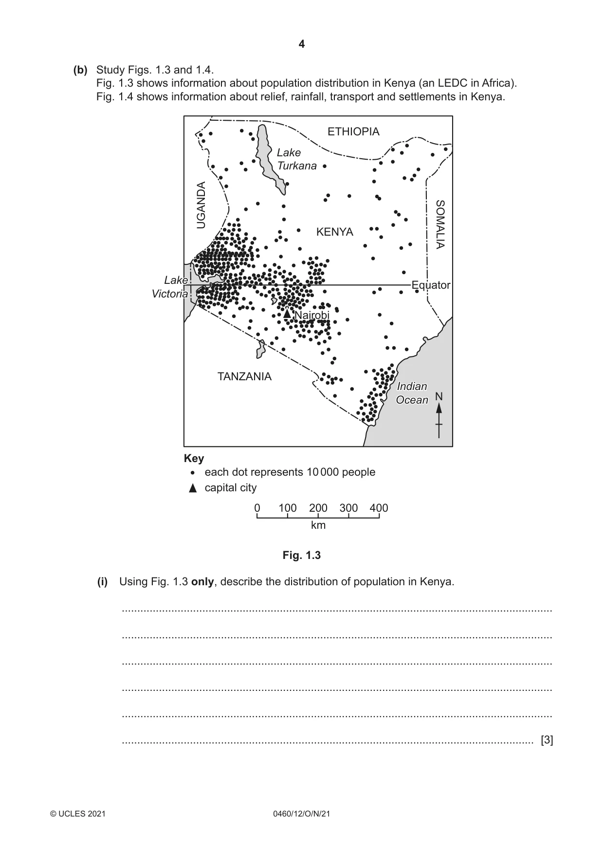
4 0460/12/O/N/21 © UCLES 2021 (b) Study Figs. 1.3 and 1.4. Fig. 1.3 shows information about population distribution in Kenya (an LEDC in Africa). Fig. 1.4 shows information about relief, rainfall, transport and settlements in Kenya. N Key each dot represents 10 000 people capital city KENYA SOMALI REPUBLIC ETHIOPIA TANZANIA Nairobi Equator Lake Turkana Lake Victoria SOMALIA ETHIOPIA UGANDA TANZANIA Nairobi Equator Lake Turkana Lake Victoria km 0 100 200 300 400 Indian Ocean Indian Ocean Fig. 1.3 (i) Using Fig. 1.3 only, describe the distribution of population in Kenya. … … … … … … [3]
Question paper, page 5
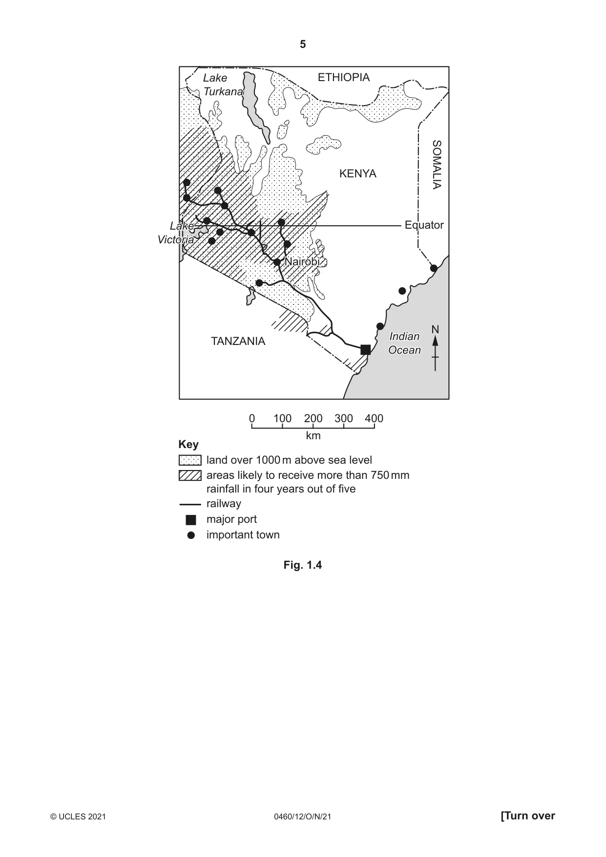
5 0460/12/O/N/21 © UCLES 2021 [Turn over N Key land over 1000 m above sea level areas likely to receive more than 750 mm rainfall in four years out of five railway major port important town KENYA SOMALI REPUBLIC ETHIOPIA TANZANIA Nairobi Equator Lake Turkana SOMALIA ETHIOPIA TANZANIA Nairobi Equator Lake Turkana km 0 100 200 300 400 Indian Ocean Indian Ocean Lake Victoria Lake Victoria Fig. 1.4
Question paper, page 6
6 0460/12/O/N/21 © UCLES 2021 (ii) Using information from Figs. 1.3 and 1.4 only, suggest reasons for the distribution of population in Kenya. … … … … … … … … … … [5]
Question paper, page 7
7 0460/12/O/N/21 © UCLES 2021 [Turn over (c) For a named country you have studied, describe the impacts of overpopulation. Name of country … … … … … … … … … … … … … … … … … … … … … … … … … … [7] [Total: 25]
Question paper, page 8
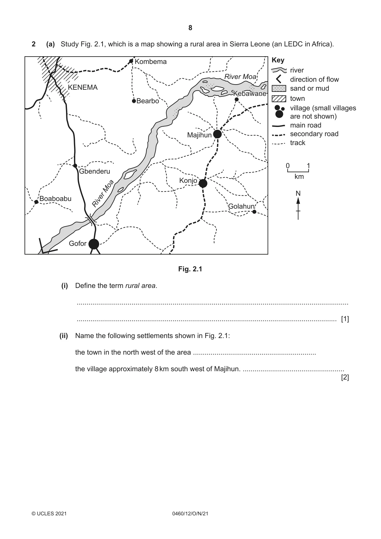
8 0460/12/O/N/21 © UCLES 2021 2 (a) Study Fig. 2.1, which is a map showing a rural area in Sierra Leone (an LEDC in Africa). Gofor Kombema Bearbo KENEMA Boaboabu Gbenderu Gofor Konjo Golahun Kebawane Golahun Majihun Kebawane River Moa River Moa N km 0 1 Key river direction of flow sand or mud town village (small villages are not shown) main road secondary road track Fig. 2.1 (i) Define the term rural area. … … [1] (ii) Name the following settlements shown in Fig. 2.1: the town in the north west of the area … the village approximately 8 km south west of Majihun. … [2]
Question paper, page 9
9 0460/12/O/N/21 © UCLES 2021 [Turn over (iii) Choose one service from the list below which may be available in a village. Give reasons for your choice. general store hospital jewellers shoe shop Service … Reasons … … … … … [3] (iv) The only secondary school in the area shown in Fig. 2.1 is in Kenema. Suggest why only a few of the children who live in Konjo are likely to attend secondary school. … … … … … … … … [4]
Question paper, page 10
10 0460/12/O/N/21 © UCLES 2021 (b) Study Fig. 2.2, which shows three different rural settlement patterns. Fig. 2.2 (i) Name the settlement pattern shown in each of maps A, B and C. Map A … Map B … Map C … [3] (ii) Explain why different settlement patterns develop in rural areas. … … … … … … … … … … … [5] Content removed due to copyright restrictions.
Question paper, page 11
11 0460/12/O/N/21 © UCLES 2021 [Turn over (c) For a named urban area you have studied, describe and explain the characteristics of the Central Business District (CBD). Name of urban area … … … … … … … … … … … … … … … … … … … … … … … … … … [7] [Total: 25]
Question paper, page 12
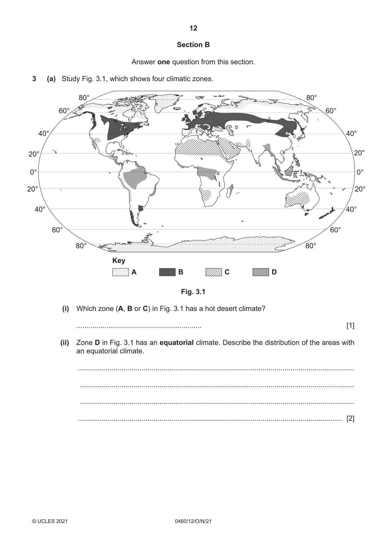
12 0460/12/O/N/21 © UCLES 2021 Section B Answer one question from this section. 3 (a) Study Fig. 3.1, which shows four climatic zones. Key A B C D 0° 20° 0° 20° 20° 20° 40° 40° 40° 40° 60° 60° 80° 60° 80° 80° 60° 80° Fig. 3.1 (i) Which zone (A, B or C) in Fig. 3.1 has a hot desert climate? … [1] (ii) Zone D in Fig. 3.1 has an equatorial climate. Describe the distribution of the areas with an equatorial climate. … … … … [2]
Question paper, page 13
13 0460/12/O/N/21 © UCLES 2021 [Turn over (iii) Explain why temperatures are high all year round in equatorial areas. … … … … … … [3] (iv) Explain why rainfall is very low in hot desert areas. … … … … … … … … [4]
Question paper, page 14
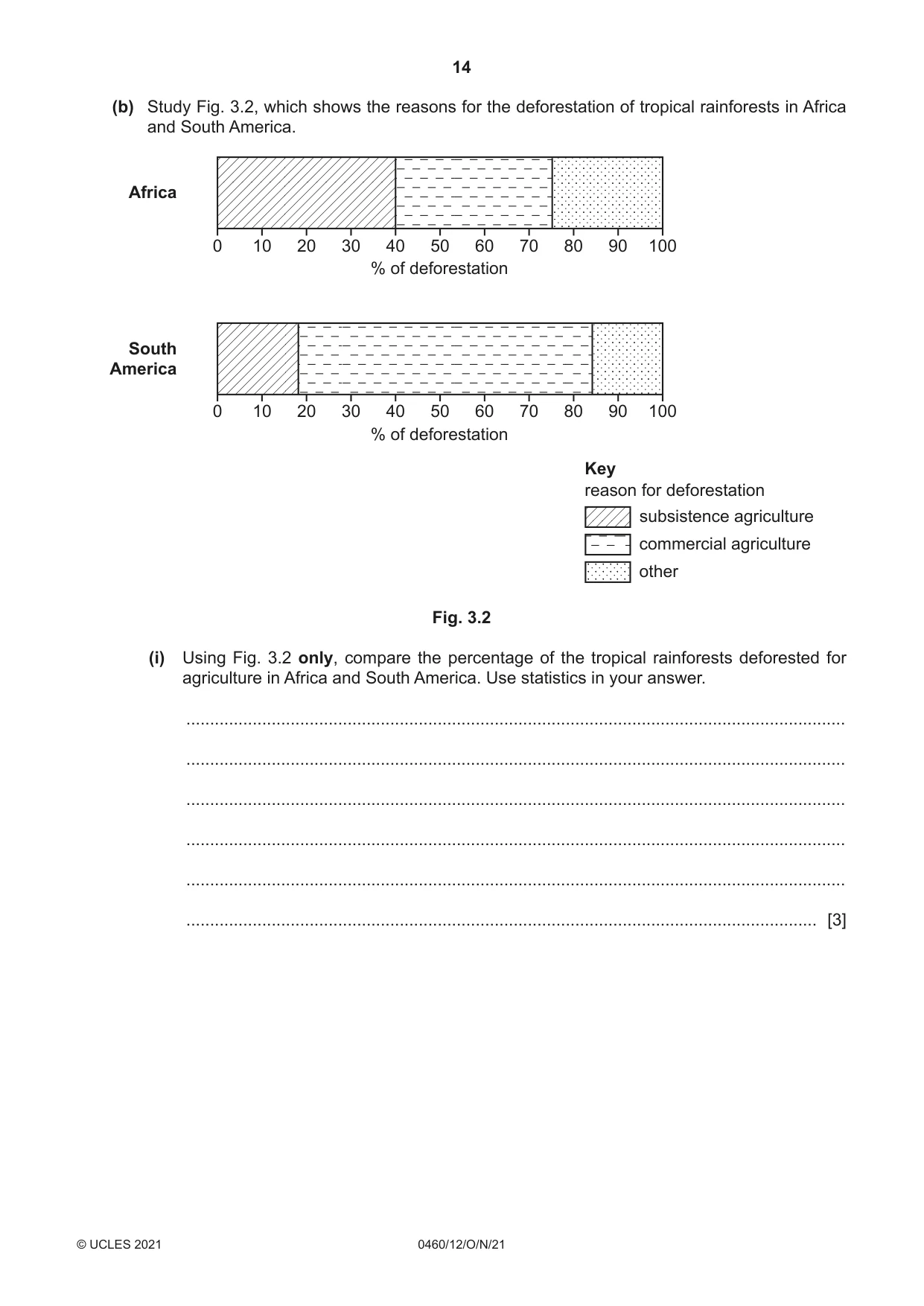
14 0460/12/O/N/21 © UCLES 2021 (b) Study Fig. 3.2, which shows the reasons for the deforestation of tropical rainforests in Africa and South America. Africa South America 0 10 20 30 40 50 60 70 80 90 100 % of deforestation 0 10 20 30 40 50 60 70 80 90 100 % of deforestation Key reason for deforestation subsistence agriculture commercial agriculture other Fig. 3.2 (i) Using Fig. 3.2 only, compare the percentage of the tropical rainforests deforested for agriculture in Africa and South America. Use statistics in your answer. … … … … … … [3]
Question paper, page 15
15 0460/12/O/N/21 © UCLES 2021 [Turn over (ii) Suggest other reasons (not agriculture) why the tropical rainforest in Africa and South America has been deforested. … … … … … … … … … … [5]
Question paper, page 16
16 0460/12/O/N/21 © UCLES 2021 (c) For a named area of tropical rainforest you have studied, explain how deforestation is threatening the local natural environment. Area of tropical rainforest … … … … … … … … … … … … … … … … … … … … … … … … … … [7] [Total: 25]
Question paper, page 17
17 0460/12/O/N/21 © UCLES 2021 [Turn over 4 (a) Study Figs. 4.1, 4.2, 4.3 and 4.4 (Insert), which are photographs taken in the Borders region of Scotland. This is an area where coastal erosion is taking place. (i) What is meant by the term coastal erosion? … … [1] (ii) Use the following descriptions to identify the correct photograph from Figs. 4.1, 4.2, 4.3 and 4.4. - a cliff coastline with a stack, stumps and one large wave-cut platform Fig. … - a sandy bay with separate small areas of wave-cut platform exposed at low tide. Fig. … [2] (iii) The coastline shown in Figs. 4.1, 4.2, 4.3 and 4.4 has been eroded by corrasion (abrasion), corrosion and hydraulic action. Define these terms. corrasion (abrasion) … … … corrosion … … … hydraulic action … … … [3]
Question paper, page 18
18 0460/12/O/N/21 © UCLES 2021 (iv) Suggest reasons why people live along the coastline shown in Figs. 4.1, 4.2, 4.3 and 4.4. … … … … … … … … [4]
Question paper, page 19
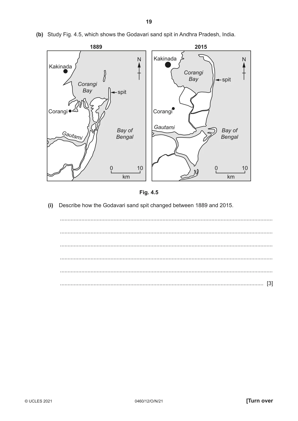
19 0460/12/O/N/21 © UCLES 2021 [Turn over (b) Study Fig. 4.5, which shows the Godavari sand spit in Andhra Pradesh, India. 1889 N km 0 10 Bay of Bengal Corangi Bay spit Kakinada Corangi Gautami 2015 N km 0 10 Bay of Bengal Corangi Bay spit Kakinada Corangi Gautami Fig. 4.5 (i) Describe how the Godavari sand spit changed between 1889 and 2015. … … … … … … [3]
Question paper, page 20
20 0460/12/O/N/21 © UCLES 2021 (ii) Suggest how coastal processes changed the Godavari sand spit between 1889 and 2015. … … … … … … … … … … [5]
Question paper, page 21
21 0460/12/O/N/21 © UCLES 2021 [Turn over (c) For a named area of coastline you have studied, explain how coastal erosion is managed. Name of area … … … … … … … … … … … … … … … … … … … … … … … … … … [7] [Total: 25]
Question paper, page 22
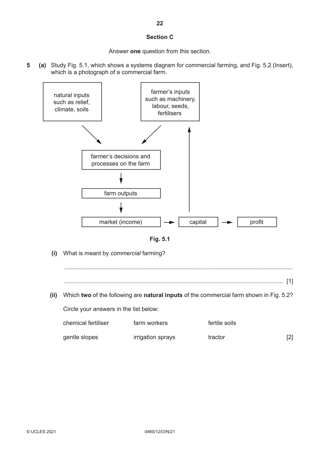
22 0460/12/O/N/21 © UCLES 2021 Section C Answer one question from this section. 5 (a) Study Fig. 5.1, which shows a systems diagram for commercial farming, and Fig. 5.2 (Insert), which is a photograph of a commercial farm. natural inputs such as relief, climate, soils farmer’s inputs such as machinery, labour, seeds, fertilisers farmer’s decisions and processes on the farm farm outputs market (income) capital profit Fig. 5.1 (i) What is meant by commercial farming? … … [1] (ii) Which two of the following are natural inputs of the commercial farm shown in Fig. 5.2? Circle your answers in the list below: chemical fertiliser farm workers fertile soils gentle slopes irrigation sprays tractor [2]
Question paper, page 23
23 0460/12/O/N/21 © UCLES 2021 [Turn over (iii) Explain how farmers can benefit from being near a large urban area. … … … … … … [3] (iv) State two different climatic factors which affect farming. For each factor give an example of how it can influence land use. 1 … … … … 2 … … … … [4]
Question paper, page 24
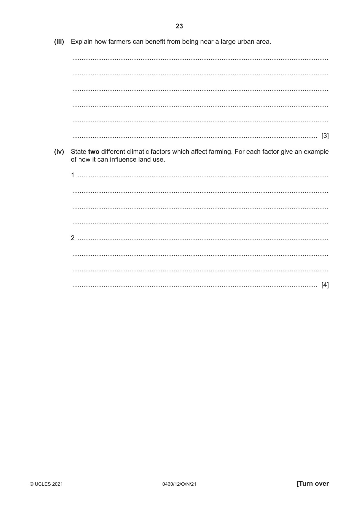
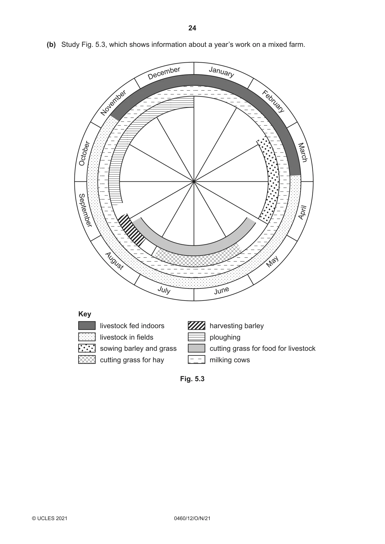
24 0460/12/O/N/21 © UCLES 2021 (b) Study Fig. 5.3, which shows information about a year’s work on a mixed farm. Key livestock fed indoors livestock in fields sowing barley and grass cutting grass for hay harvesting barley ploughing cutting grass for food for livestock milking cows J un e M ay A pr il J ul y A ug us t S ep te mb er De ce mb er N ov em be r Oc to be r J an ua ry Fe br ua ry Ma rc h Fig. 5.3
Question paper, page 25
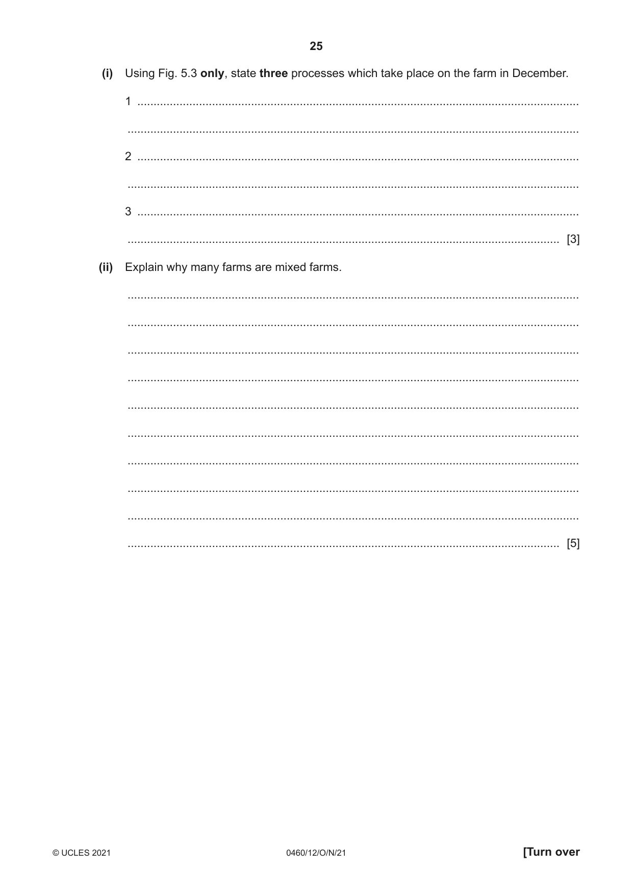
25 0460/12/O/N/21 © UCLES 2021 [Turn over (i) Using Fig. 5.3 only, state three processes which take place on the farm in December. 1 … … 2 … … 3 … … [3] (ii) Explain why many farms are mixed farms. … … … … … … … … … … [5]
Question paper, page 26
26 0460/12/O/N/21 © UCLES 2021 (c) For a named country or region you have studied, explain why food shortages occur. Name of country or region … … … … … … … … … … … … … … … … … … … … … … … … … … … [7] [Total: 25]
Question paper, page 27
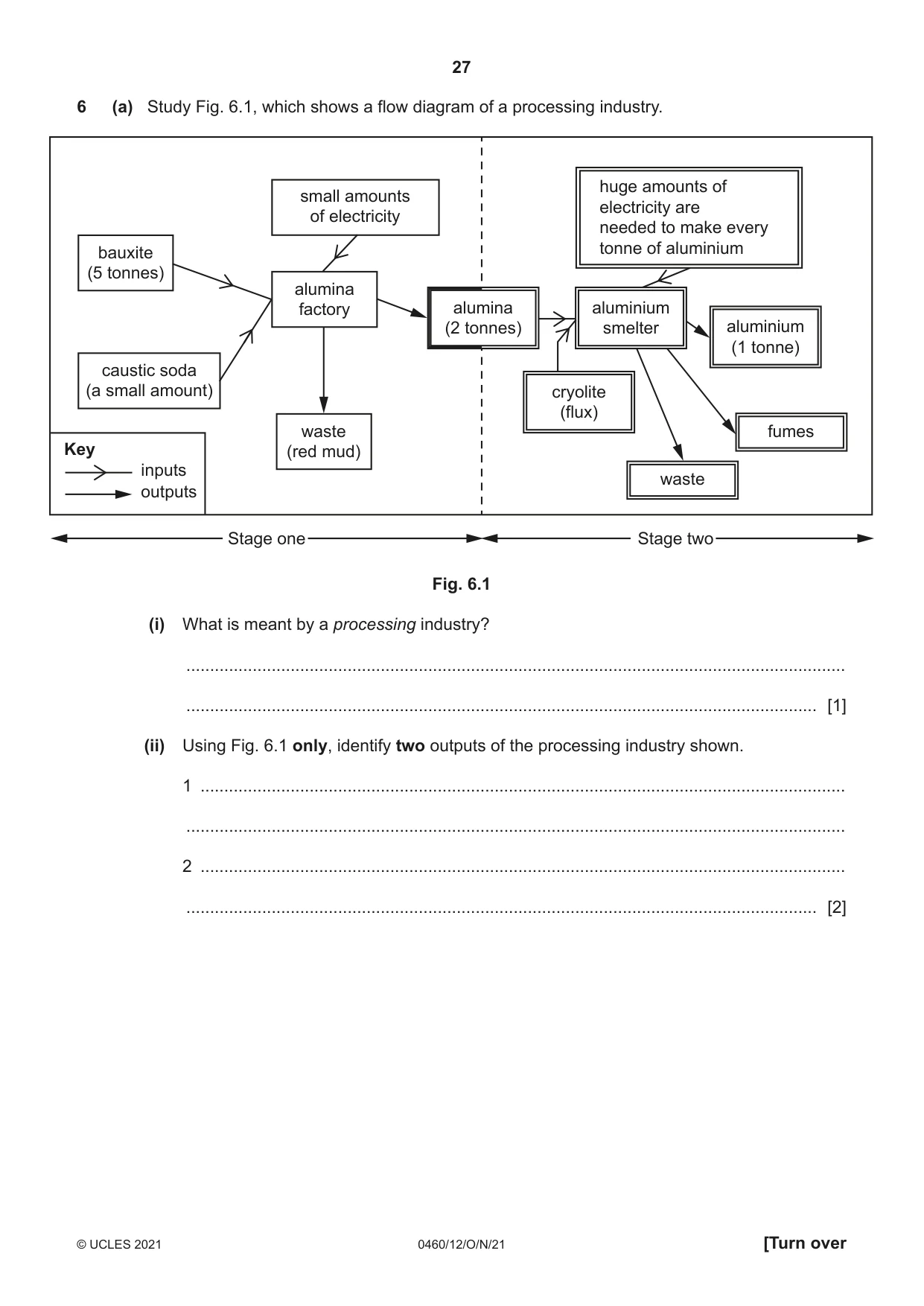
27 0460/12/O/N/21 © UCLES 2021 [Turn over 6 (a) Study Fig. 6.1, which shows a flow diagram of a processing industry. bauxite (5 tonnes) caustic soda (a small amount) waste (red mud) alumina factory alumina (2 tonnes) aluminium smelter small amounts of electricity huge amounts of electricity are needed to make every tonne of aluminium aluminium (1 tonne) cryolite (flux) waste fumes Key inputs outputs Stage one Stage two Fig. 6.1 (i) What is meant by a processing industry? … … [1] (ii) Using Fig. 6.1 only, identify two outputs of the processing industry shown. 1 … … 2 … … [2]
Question paper, page 28
28 0460/12/O/N/21 © UCLES 2021 (iii) Suggest reasons why the alumina factory in Stage 1 of the processing industry shown in Fig. 6.1 is located close to areas where bauxite is quarried. … … … … … … [3] (iv) Explain why many companies which produce aluminium build their own hydro-electric power (HEP) stations next to the alumina smelters shown in Stage 2 of Fig. 6.1. … … … … … … … … [4]
Question paper, page 29
29 0460/12/O/N/21 © UCLES 2021 [Turn over (b) Study Fig. 6.2 (Insert), which shows a map of part of Cape Town in South Africa. (i) Suggest how the following have encouraged the growth of manufacturing industry in Cape Town. Roads and railways … … … Docks … … … A large urban population … … … [3] (ii) Suggest reasons why the owners of some factories in Cape Town are considering moving their factories to different locations. … … … … … … … … … … [5]
Question paper, page 30
30 0460/12/O/N/21 © UCLES 2021 (c) For a named country or area you have studied, explain how sufficient water is supplied for industrial use. Name of country or area … … … … … … … … … … … … … … … … … … … … … … … … … … [7] [Total: 25]
Question paper, page 31
31 0460/12/O/N/21 © UCLES 2021 Additional Pages If you use the following lined pages to complete the answer(s) to any question(s), the question number(s) must be clearly shown. … … … … … … … … … … … … … … … … … … … … … … … … … …
Question paper, page 32
32 0460/12/O/N/21 © UCLES 2021 … … … … … … … … … … … … … … … … … … … … … … … The boundaries and names shown, the designations used and the presentation of material on any maps contained in this question paper/insert do not imply official endorsement or acceptance by Cambridge Assessment International Education concerning the legal status of any country, territory, or area or any of its authorities, or of the delimitation of its frontiers or boundaries. Permission to reproduce items where third-party owned material protected by copyright is included has been sought and cleared where possible. Every reasonable effort has been made by the publisher (UCLES) to trace copyright holders, but if any items requiring clearance have unwittingly been included, the publisher will be pleased to make amends at the earliest possible opportunity. To avoid the issue of disclosure of answer-related information to candidates, all copyright acknowledgements are reproduced online in the Cambridge Assessment International Education Copyright Acknowledgements Booklet. This is produced for each series of examinations and is freely available to download at www.cambridgeinternational.org after the live examination series. Cambridge Assessment International Education is part of the Cambridge Assessment Group. Cambridge Assessment is the brand name of the University of Cambridge Local Examinations Syndicate (UCLES), which itself is a department of the University of Cambridge.
Mark scheme, page 1
This document consists of 18 printed pages. © UCLES 2021 [Turn over Cambridge IGCSE™ GEOGRAPHY 0460/12 Paper 1 October/November 2021 MARK SCHEME Maximum Mark: 75 Published This mark scheme is published as an aid to teachers and candidates, to indicate the requirements of the examination. It shows the basis on which Examiners were instructed to award marks. It does not indicate the details of the discussions that took place at an Examiners’ meeting before marking began, which would have considered the acceptability of alternative answers. Mark schemes should be read in conjunction with the question paper and the Principal Examiner Report for Teachers. Cambridge International will not enter into discussions about these mark schemes. Cambridge International is publishing the mark schemes for the October/November 2021 series for most Cambridge IGCSE™, Cambridge International A and AS Level components and some Cambridge O Level components.
Mark scheme, page 2
0460/12 Cambridge IGCSE – Mark Scheme PUBLISHED October/November 2021 © UCLES 2021 Page 2 of 18 Generic Marking Principles These general marking principles must be applied by all examiners when marking candidate answers. They should be applied alongside the specific content of the mark scheme or generic level descriptors for a question. Each question paper and mark scheme will also comply with these marking principles. GENERIC MARKING PRINCIPLE 1: Marks must be awarded in line with: • the specific content of the mark scheme or the generic level descriptors for the question • the specific skills defined in the mark scheme or in the generic level descriptors for the question • the standard of response required by a candidate as exemplified by the standardisation scripts. GENERIC MARKING PRINCIPLE 2: Marks awarded are always whole marks (not half marks, or other fractions). GENERIC MARKING PRINCIPLE 3: Marks must be awarded positively: • marks are awarded for correct/valid answers, as defined in the mark scheme. However, credit is given for valid answers which go beyond the scope of the syllabus and mark scheme, referring to your Team Leader as appropriate • marks are awarded when candidates clearly demonstrate what they know and can do • marks are not deducted for errors • marks are not deducted for omissions • answers should only be judged on the quality of spelling, punctuation and grammar when these features are specifically assessed by the question as indicated by the mark scheme. The meaning, however, should be unambiguous. GENERIC MARKING PRINCIPLE 4: Rules must be applied consistently, e.g. in situations where candidates have not followed instructions or in the application of generic level descriptors. GENERIC MARKING PRINCIPLE 5: Marks should be awarded using the full range of marks defined in the mark scheme for the question (however; the use of the full mark range may be limited according to the quality of the candidate responses seen). GENERIC MARKING PRINCIPLE 6: Marks awarded are based solely on the requirements as defined in the mark scheme. Marks should not be awarded with grade thresholds or grade descriptors in mind.
Mark scheme, page 3
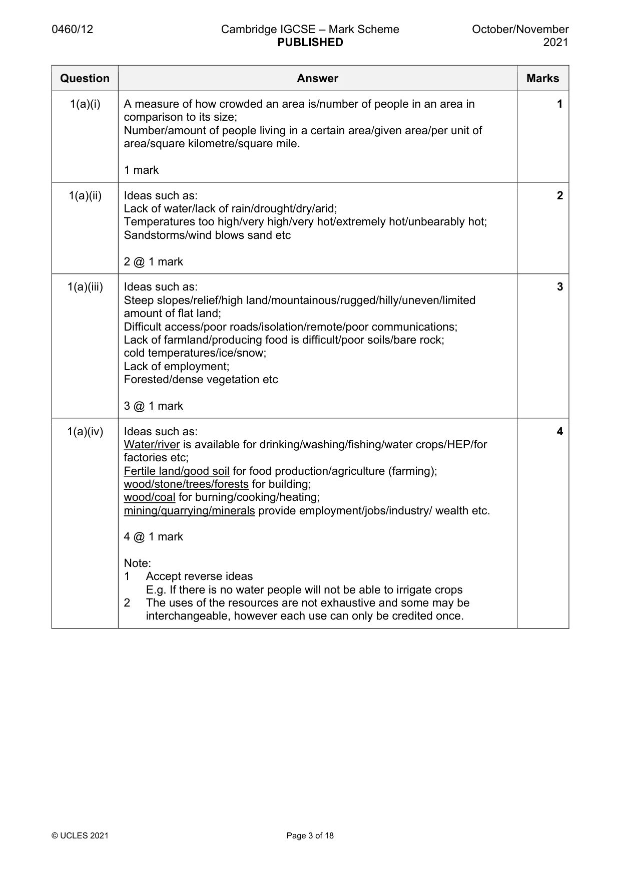
0460/12 Cambridge IGCSE – Mark Scheme PUBLISHED October/November 2021 © UCLES 2021 Page 3 of 18 Question Answer Marks 1(a)(i) A measure of how crowded an area is/number of people in an area in comparison to its size; Number/amount of people living in a certain area/given area/per unit of area/square kilometre/square mile. 1 mark 1 1(a)(ii) Ideas such as: Lack of water/lack of rain/drought/dry/arid; Temperatures too high/very high/very hot/extremely hot/unbearably hot; Sandstorms/wind blows sand etc 2 @ 1 mark 2 1(a)(iii) Ideas such as: Steep slopes/relief/high land/mountainous/rugged/hilly/uneven/limited amount of flat land; Difficult access/poor roads/isolation/remote/poor communications; Lack of farmland/producing food is difficult/poor soils/bare rock; cold temperatures/ice/snow; Lack of employment; Forested/dense vegetation etc 3 @ 1 mark 3 1(a)(iv) Ideas such as: Water/river is available for drinking/washing/fishing/water crops/HEP/for factories etc; Fertile land/good soil for food production/agriculture (farming); wood/stone/trees/forests for building; wood/coal for burning/cooking/heating; mining/quarrying/minerals provide employment/jobs/industry/ wealth etc. 4 @ 1 mark Note: 1 Accept reverse ideas E.g. If there is no water people will not be able to irrigate crops 2 The uses of the resources are not exhaustive and some may be interchangeable, however each use can only be credited once. 4
Mark scheme, page 4
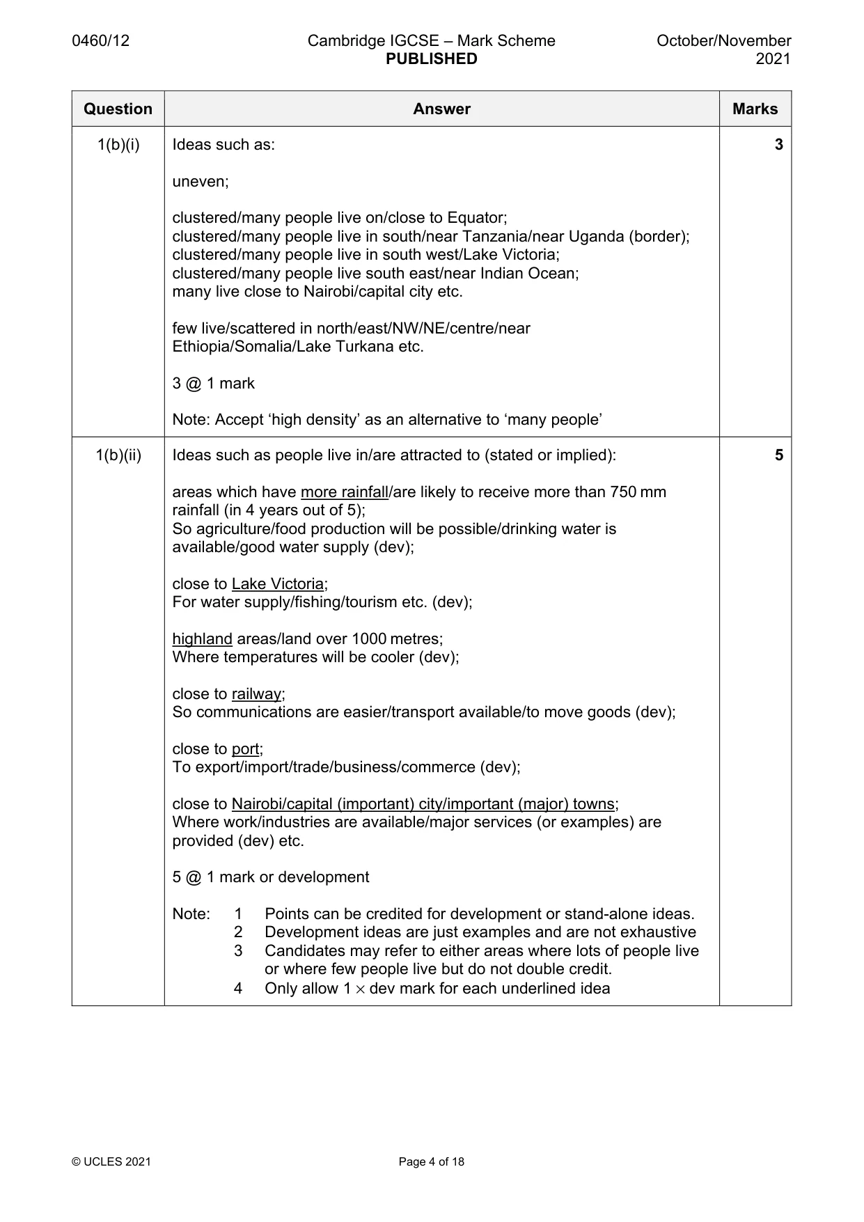
0460/12 Cambridge IGCSE – Mark Scheme PUBLISHED October/November 2021 © UCLES 2021 Page 4 of 18 Question Answer Marks 1(b)(i) Ideas such as: uneven; clustered/many people live on/close to Equator; clustered/many people live in south/near Tanzania/near Uganda (border); clustered/many people live in south west/Lake Victoria; clustered/many people live south east/near Indian Ocean; many live close to Nairobi/capital city etc. few live/scattered in north/east/NW/NE/centre/near Ethiopia/Somalia/Lake Turkana etc. 3 @ 1 mark Note: Accept ‘high density’ as an alternative to ‘many people’ 3 1(b)(ii) Ideas such as people live in/are attracted to (stated or implied): areas which have more rainfall/are likely to receive more than 750 mm rainfall (in 4 years out of 5); So agriculture/food production will be possible/drinking water is available/good water supply (dev); close to Lake Victoria; For water supply/fishing/tourism etc. (dev); highland areas/land over 1000 metres; Where temperatures will be cooler (dev); close to railway; So communications are easier/transport available/to move goods (dev); close to port; To export/import/trade/business/commerce (dev); close to Nairobi/capital (important) city/important (major) towns; Where work/industries are available/major services (or examples) are provided (dev) etc. 5 @ 1 mark or development Note: 1 Points can be credited for development or stand-alone ideas. 2 Development ideas are just examples and are not exhaustive 3 Candidates may refer to either areas where lots of people live or where few people live but do not double credit. 4 Only allow 1 × dev mark for each underlined idea 5
Mark scheme, page 5
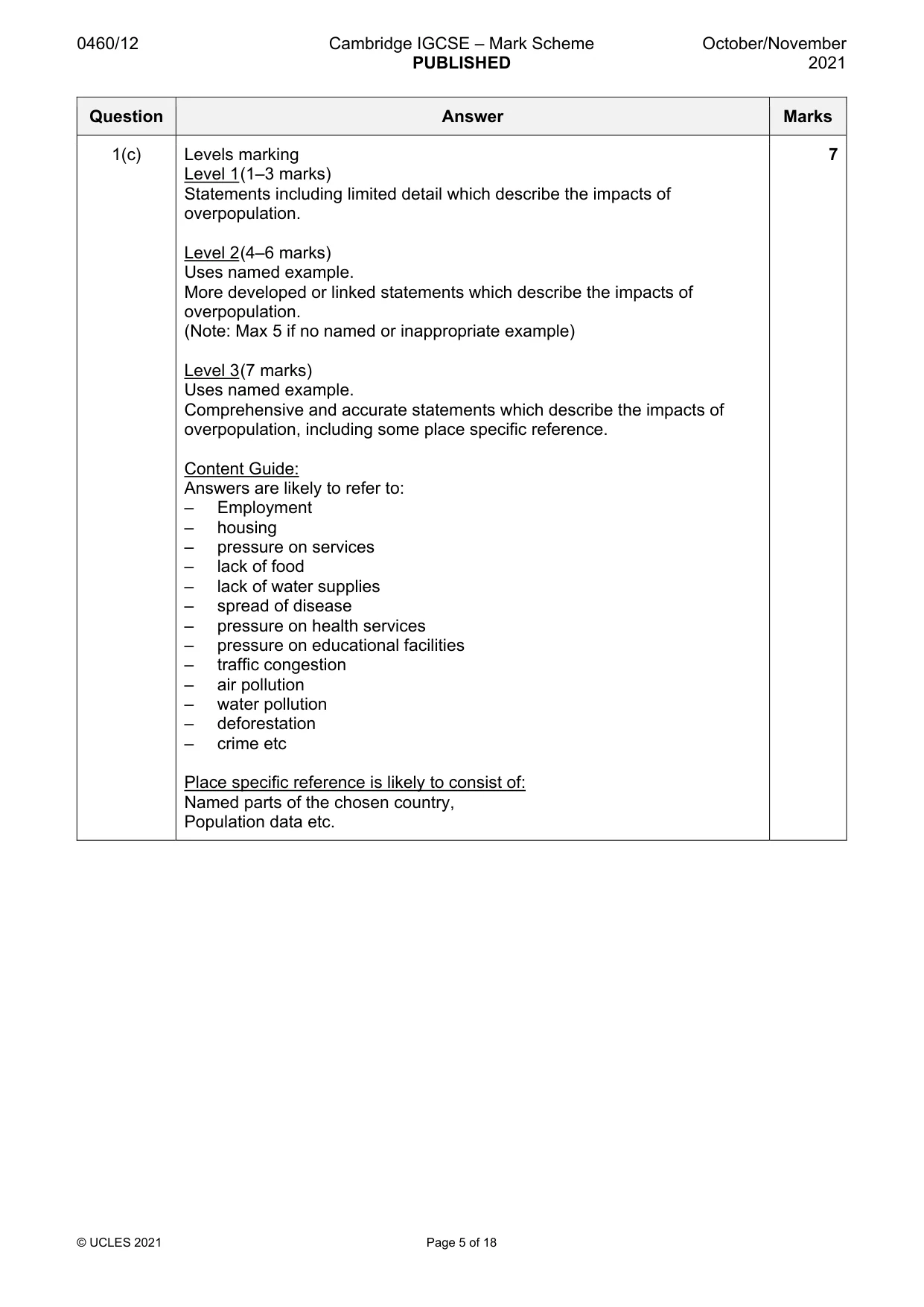
0460/12 Cambridge IGCSE – Mark Scheme PUBLISHED October/November 2021 © UCLES 2021 Page 5 of 18 Question Answer Marks 1(c) Levels marking Level 1 (1–3 marks) Statements including limited detail which describe the impacts of overpopulation. Level 2 (4–6 marks) Uses named example. More developed or linked statements which describe the impacts of overpopulation. (Note: Max 5 if no named or inappropriate example) Level 3 (7 marks) Uses named example. Comprehensive and accurate statements which describe the impacts of overpopulation, including some place specific reference. Content Guide: Answers are likely to refer to: – Employment – housing – pressure on services – lack of food – lack of water supplies – spread of disease – pressure on health services – pressure on educational facilities – traffic congestion – air pollution – water pollution – deforestation – crime etc Place specific reference is likely to consist of: Named parts of the chosen country, Population data etc. 7
Mark scheme, page 6
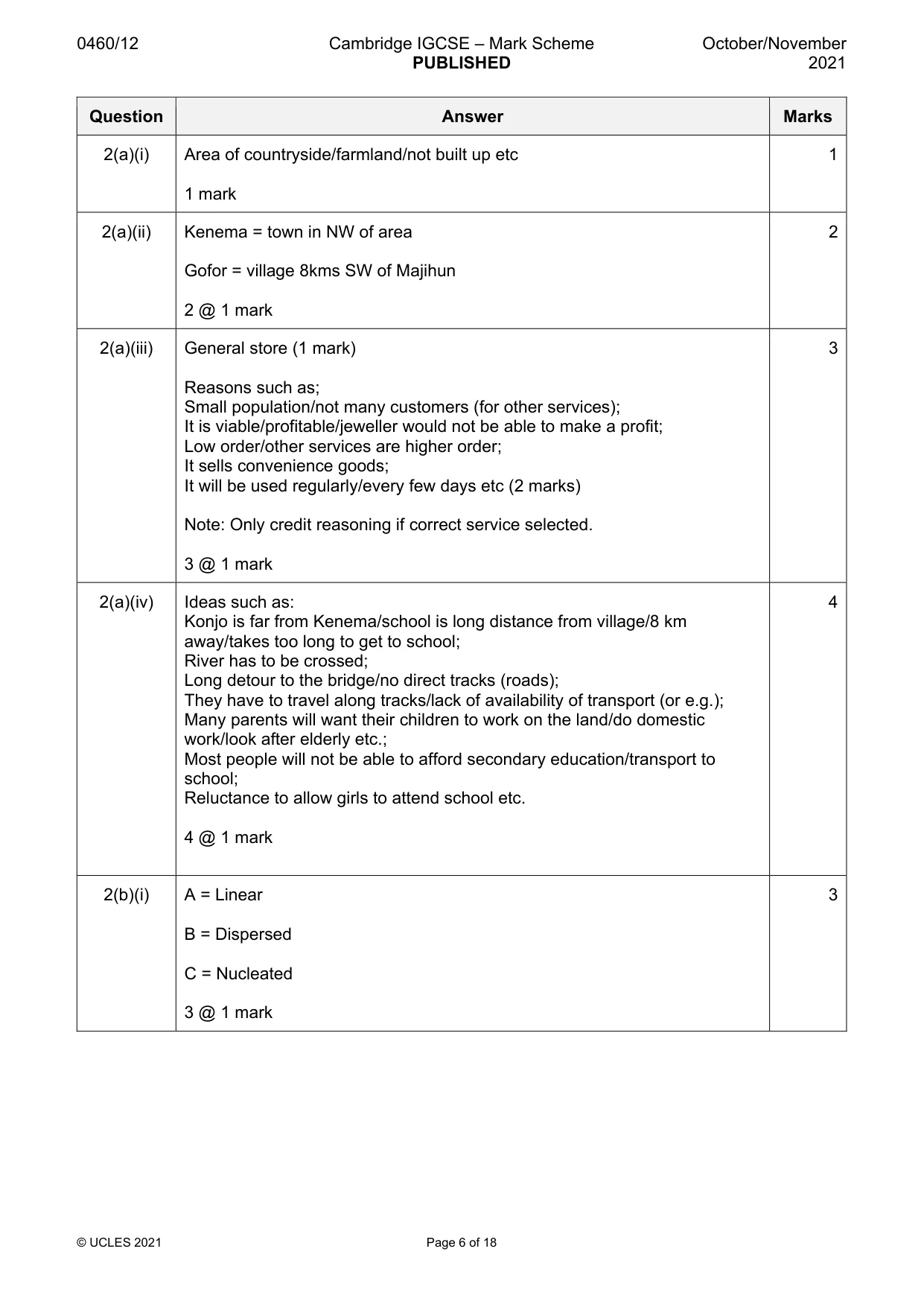
0460/12 Cambridge IGCSE – Mark Scheme PUBLISHED October/November 2021 © UCLES 2021 Page 6 of 18 Question Answer Marks 2(a)(i) Area of countryside/farmland/not built up etc 1 mark 1 2(a)(ii) Kenema = town in NW of area Gofor = village 8kms SW of Majihun 2 @ 1 mark 2 2(a)(iii) General store (1 mark) Reasons such as; Small population/not many customers (for other services); It is viable/profitable/jeweller would not be able to make a profit; Low order/other services are higher order; It sells convenience goods; It will be used regularly/every few days etc (2 marks) Note: Only credit reasoning if correct service selected. 3 @ 1 mark 3 2(a)(iv) Ideas such as: Konjo is far from Kenema/school is long distance from village/8 km away/takes too long to get to school; River has to be crossed; Long detour to the bridge/no direct tracks (roads); They have to travel along tracks/lack of availability of transport (or e.g.); Many parents will want their children to work on the land/do domestic work/look after elderly etc.; Most people will not be able to afford secondary education/transport to school; Reluctance to allow girls to attend school etc. 4 @ 1 mark 4 2(b)(i) A = Linear B = Dispersed C = Nucleated 3 @ 1 mark 3
Mark scheme, page 7
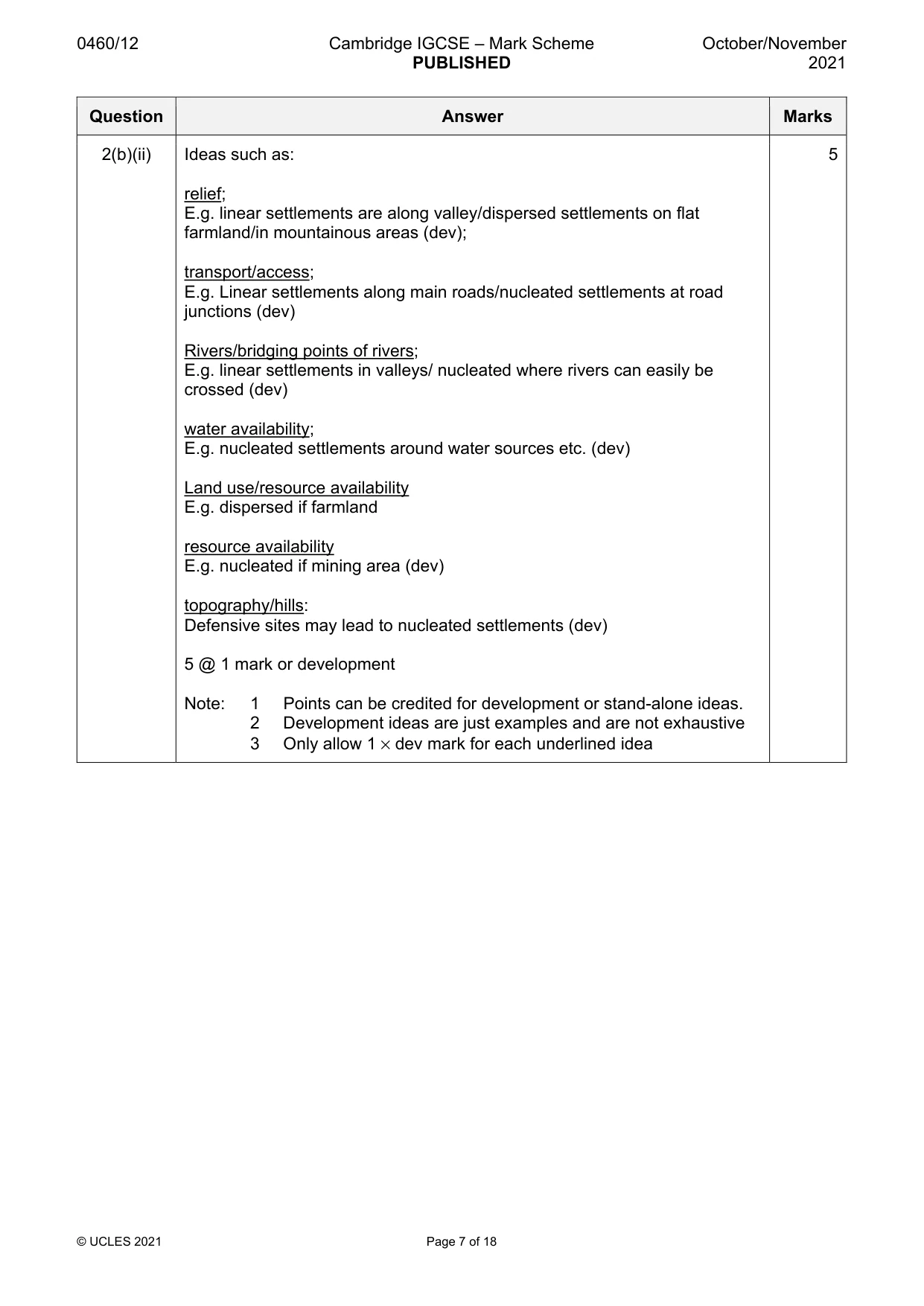
0460/12 Cambridge IGCSE – Mark Scheme PUBLISHED October/November 2021 © UCLES 2021 Page 7 of 18 Question Answer Marks 2(b)(ii) Ideas such as: relief; E.g. linear settlements are along valley/dispersed settlements on flat farmland/in mountainous areas (dev); transport/access; E.g. Linear settlements along main roads/nucleated settlements at road junctions (dev) Rivers/bridging points of rivers; E.g. linear settlements in valleys/ nucleated where rivers can easily be crossed (dev) water availability; E.g. nucleated settlements around water sources etc. (dev) Land use/resource availability E.g. dispersed if farmland resource availability E.g. nucleated if mining area (dev) topography/hills: Defensive sites may lead to nucleated settlements (dev) 5 @ 1 mark or development Note: 1 Points can be credited for development or stand-alone ideas. 2 Development ideas are just examples and are not exhaustive 3 Only allow 1 × dev mark for each underlined idea 5
Mark scheme, page 8
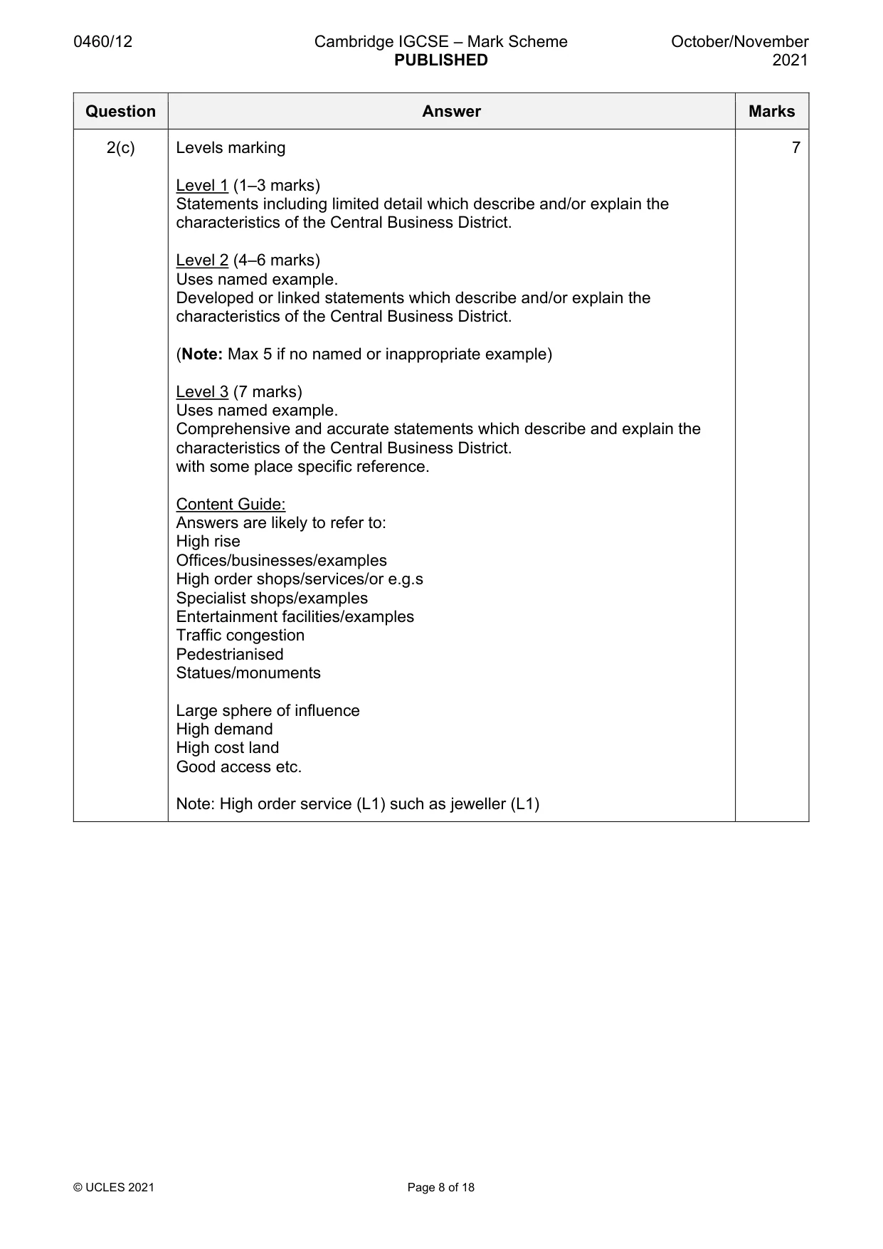
0460/12 Cambridge IGCSE – Mark Scheme PUBLISHED October/November 2021 © UCLES 2021 Page 8 of 18 Question Answer Marks 2(c) Levels marking Level 1 (1–3 marks) Statements including limited detail which describe and/or explain the characteristics of the Central Business District. Level 2 (4–6 marks) Uses named example. Developed or linked statements which describe and/or explain the characteristics of the Central Business District. (Note: Max 5 if no named or inappropriate example) Level 3 (7 marks) Uses named example. Comprehensive and accurate statements which describe and explain the characteristics of the Central Business District. with some place specific reference. Content Guide: Answers are likely to refer to: High rise Offices/businesses/examples High order shops/services/or e.g.s Specialist shops/examples Entertainment facilities/examples Traffic congestion Pedestrianised Statues/monuments Large sphere of influence High demand High cost land Good access etc. Note: High order service (L1) such as jeweller (L1) 7
Mark scheme, page 9
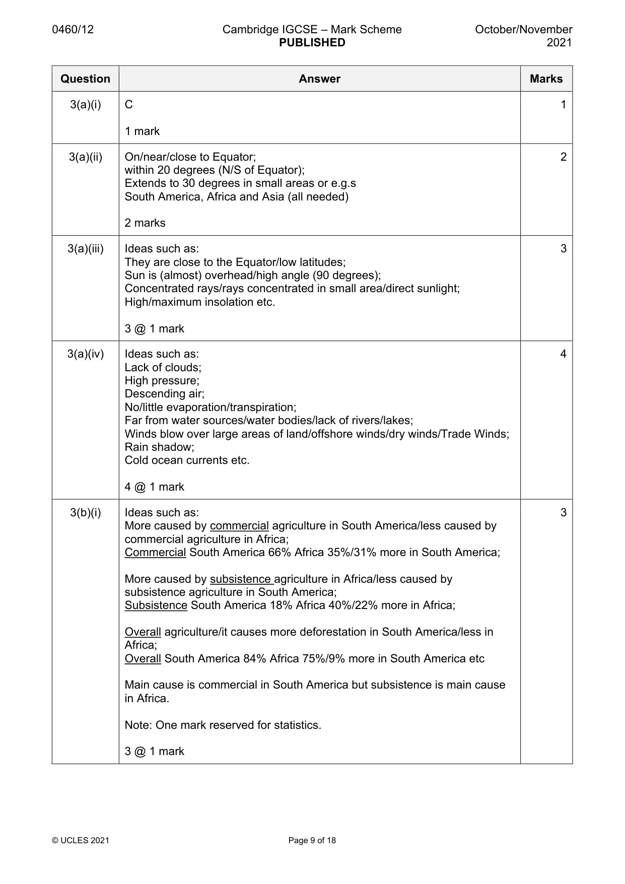
0460/12 Cambridge IGCSE – Mark Scheme PUBLISHED October/November 2021 © UCLES 2021 Page 9 of 18 Question Answer Marks 3(a)(i) C 1 mark 1 3(a)(ii) On/near/close to Equator; within 20 degrees (N/S of Equator); Extends to 30 degrees in small areas or e.g.s South America, Africa and Asia (all needed) 2 marks 2 3(a)(iii) Ideas such as: They are close to the Equator/low latitudes; Sun is (almost) overhead/high angle (90 degrees); Concentrated rays/rays concentrated in small area/direct sunlight; High/maximum insolation etc. 3 @ 1 mark 3 3(a)(iv) Ideas such as: Lack of clouds; High pressure; Descending air; No/little evaporation/transpiration; Far from water sources/water bodies/lack of rivers/lakes; Winds blow over large areas of land/offshore winds/dry winds/Trade Winds; Rain shadow; Cold ocean currents etc. 4 @ 1 mark 4 3(b)(i) Ideas such as: More caused by commercial agriculture in South America/less caused by commercial agriculture in Africa; Commercial South America 66% Africa 35%/31% more in South America; More caused by subsistence agriculture in Africa/less caused by subsistence agriculture in South America; Subsistence South America 18% Africa 40%/22% more in Africa; Overall agriculture/it causes more deforestation in South America/less in Africa; Overall South America 84% Africa 75%/9% more in South America etc Main cause is commercial in South America but subsistence is main cause in Africa. Note: One mark reserved for statistics. 3 @ 1 mark 3
Mark scheme, page 10
0460/12 Cambridge IGCSE – Mark Scheme PUBLISHED October/November 2021 © UCLES 2021 Page 10 of 18 Question Answer Marks 3(b)(ii) Ideas such as: Logging/timber; E.g. hardwoods or examples/high value wood/charcoal/firewood/paper making/use for furniture/for export/to earn foreign currency/building materials Mining/quarrying/extract minerals; E.g. for oil/iron ore etc. Road building/railways/transport; For access to resources/transport of timber/to connect areas of mining/logging or e.g. Trans-Amazonian Highway; Settlement/build houses/growth of cities; Resettlement schemes/increasing population growth; Industrial development/build factories; Processing of raw materials/resources or e.g.s; Dams/reservoirs; For generation of HEP Little regulation/enforcement of regulations; Profit is being put before the environment etc. 5 @ 1 mark or development Note: 1 Points can be credited for development or stand-alone ideas. 2 Development ideas are just examples and are not exhaustive 3 Only allow 1 × dev mark for each idea 5
Mark scheme, page 11
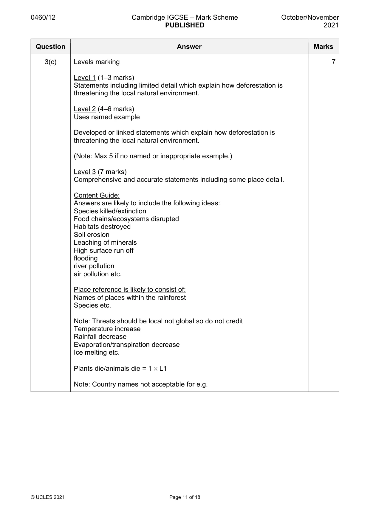
0460/12 Cambridge IGCSE – Mark Scheme PUBLISHED October/November 2021 © UCLES 2021 Page 11 of 18 Question Answer Marks 3(c) Levels marking Level 1 (1–3 marks) Statements including limited detail which explain how deforestation is threatening the local natural environment. Level 2 (4–6 marks) Uses named example Developed or linked statements which explain how deforestation is threatening the local natural environment. (Note: Max 5 if no named or inappropriate example.) Level 3 (7 marks) Comprehensive and accurate statements including some place detail. Content Guide: Answers are likely to include the following ideas: Species killed/extinction Food chains/ecosystems disrupted Habitats destroyed Soil erosion Leaching of minerals High surface run off flooding river pollution air pollution etc. Place reference is likely to consist of: Names of places within the rainforest Species etc. Note: Threats should be local not global so do not credit Temperature increase Rainfall decrease Evaporation/transpiration decrease Ice melting etc. Plants die/animals die = 1 × L1 Note: Country names not acceptable for e.g. 7
Mark scheme, page 12
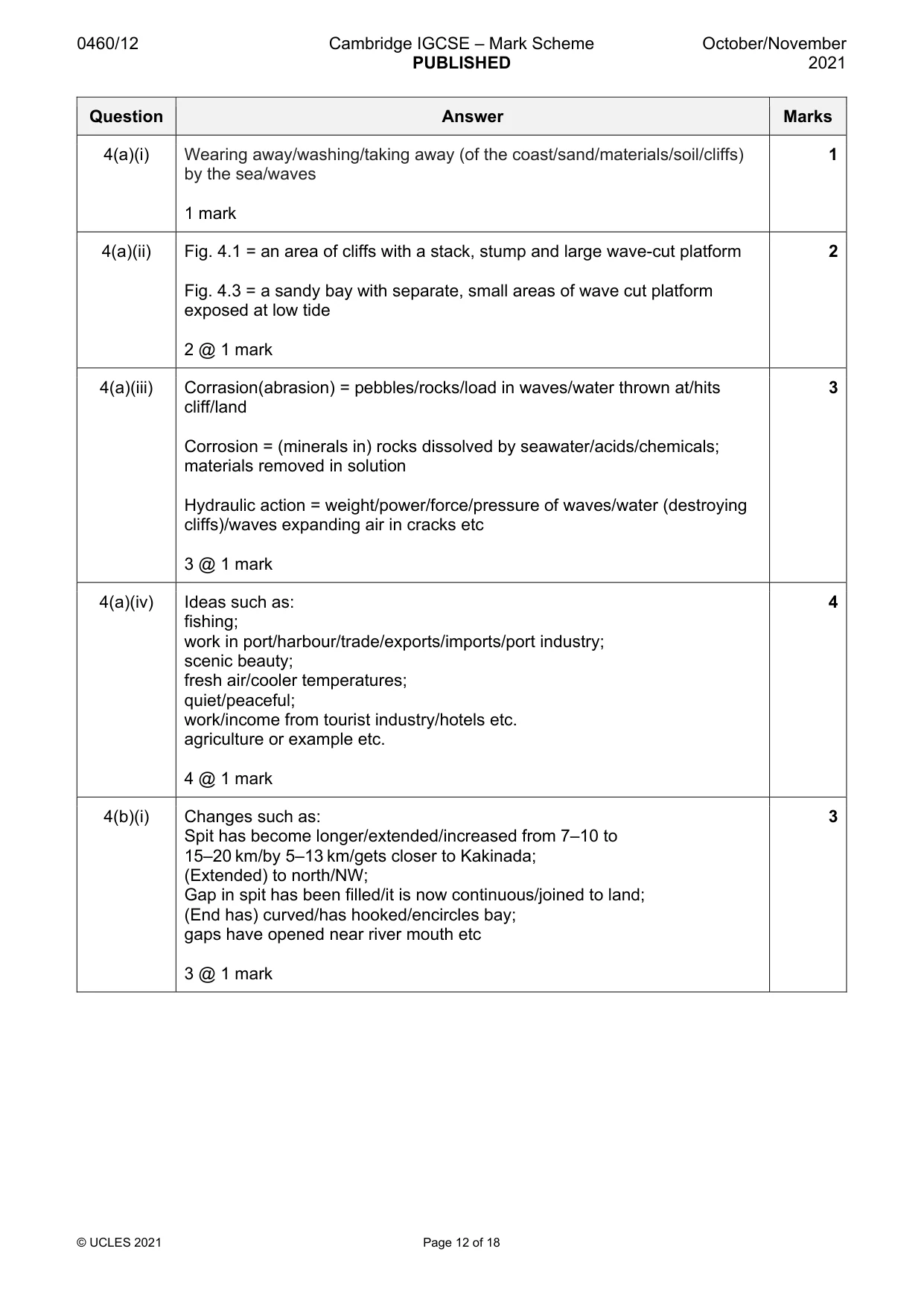
0460/12 Cambridge IGCSE – Mark Scheme PUBLISHED October/November 2021 © UCLES 2021 Page 12 of 18 Question Answer Marks 4(a)(i) Wearing away/washing/taking away (of the coast/sand/materials/soil/cliffs) by the sea/waves 1 mark 1 4(a)(ii) Fig. 4.1 = an area of cliffs with a stack, stump and large wave-cut platform Fig. 4.3 = a sandy bay with separate, small areas of wave cut platform exposed at low tide 2 @ 1 mark 2 4(a)(iii) Corrasion(abrasion) = pebbles/rocks/load in waves/water thrown at/hits cliff/land Corrosion = (minerals in) rocks dissolved by seawater/acids/chemicals; materials removed in solution Hydraulic action = weight/power/force/pressure of waves/water (destroying cliffs)/waves expanding air in cracks etc 3 @ 1 mark 3 4(a)(iv) Ideas such as: fishing; work in port/harbour/trade/exports/imports/port industry; scenic beauty; fresh air/cooler temperatures; quiet/peaceful; work/income from tourist industry/hotels etc. agriculture or example etc. 4 @ 1 mark 4 4(b)(i) Changes such as: Spit has become longer/extended/increased from 7–10 to 15–20 km/by 5–13 km/gets closer to Kakinada; (Extended) to north/NW; Gap in spit has been filled/it is now continuous/joined to land; (End has) curved/has hooked/encircles bay; gaps have opened near river mouth etc 3 @ 1 mark 3
Mark scheme, page 13
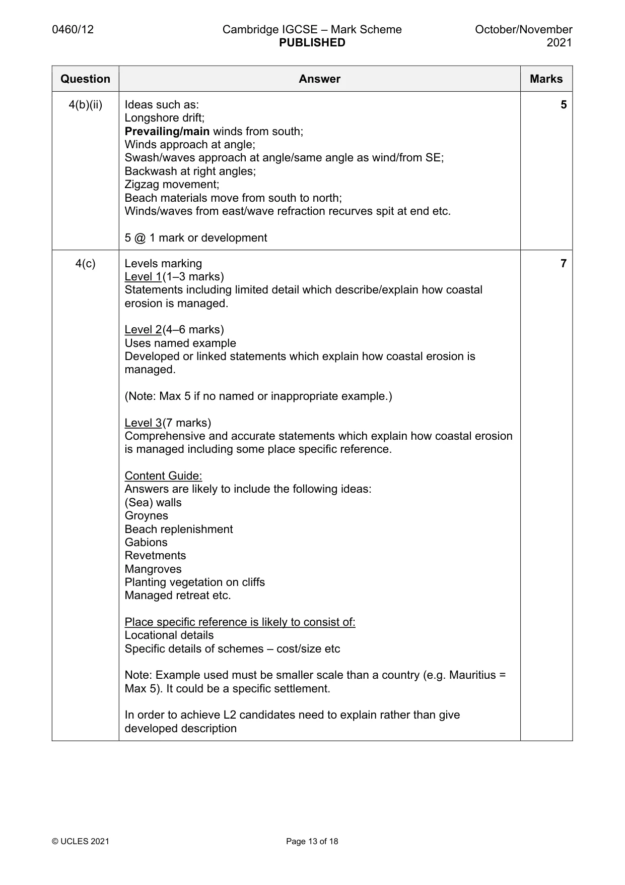
0460/12 Cambridge IGCSE – Mark Scheme PUBLISHED October/November 2021 © UCLES 2021 Page 13 of 18 Question Answer Marks 4(b)(ii) Ideas such as: Longshore drift; Prevailing/main winds from south; Winds approach at angle; Swash/waves approach at angle/same angle as wind/from SE; Backwash at right angles; Zigzag movement; Beach materials move from south to north; Winds/waves from east/wave refraction recurves spit at end etc. 5 @ 1 mark or development 5 4(c) Levels marking Level 1 (1–3 marks) Statements including limited detail which describe/explain how coastal erosion is managed. Level 2 (4–6 marks) Uses named example Developed or linked statements which explain how coastal erosion is managed. (Note: Max 5 if no named or inappropriate example.) Level 3 (7 marks) Comprehensive and accurate statements which explain how coastal erosion is managed including some place specific reference. Content Guide: Answers are likely to include the following ideas: (Sea) walls Groynes Beach replenishment Gabions Revetments Mangroves Planting vegetation on cliffs Managed retreat etc. Place specific reference is likely to consist of: Locational details Specific details of schemes – cost/size etc Note: Example used must be smaller scale than a country (e.g. Mauritius = Max 5). It could be a specific settlement. In order to achieve L2 candidates need to explain rather than give developed description 7
Mark scheme, page 14
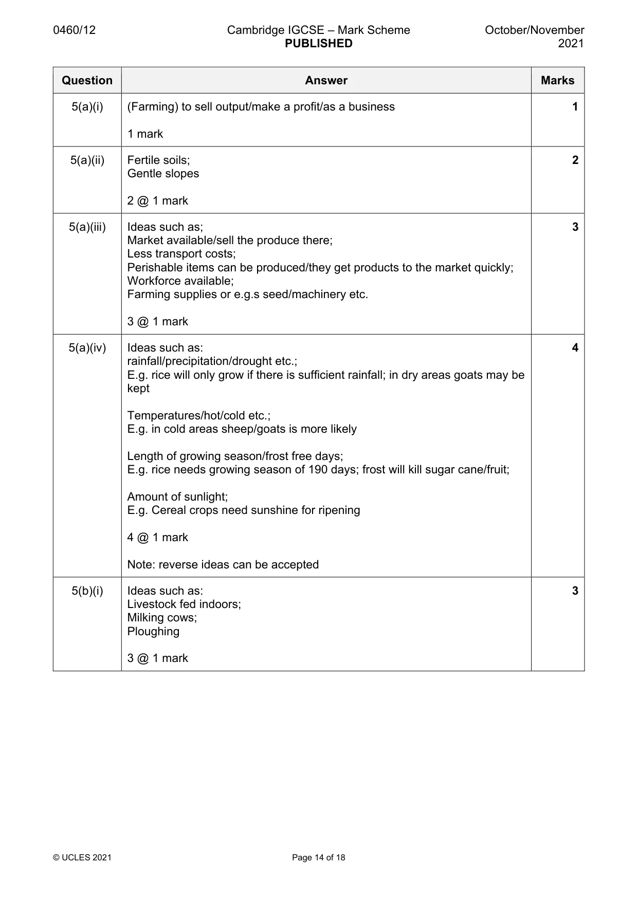
0460/12 Cambridge IGCSE – Mark Scheme PUBLISHED October/November 2021 © UCLES 2021 Page 14 of 18 Question Answer Marks 5(a)(i) (Farming) to sell output/make a profit/as a business 1 mark 1 5(a)(ii) Fertile soils; Gentle slopes 2 @ 1 mark 2 5(a)(iii) Ideas such as; Market available/sell the produce there; Less transport costs; Perishable items can be produced/they get products to the market quickly; Workforce available; Farming supplies or e.g.s seed/machinery etc. 3 @ 1 mark 3 5(a)(iv) Ideas such as: rainfall/precipitation/drought etc.; E.g. rice will only grow if there is sufficient rainfall; in dry areas goats may be kept Temperatures/hot/cold etc.; E.g. in cold areas sheep/goats is more likely Length of growing season/frost free days; E.g. rice needs growing season of 190 days; frost will kill sugar cane/fruit; Amount of sunlight; E.g. Cereal crops need sunshine for ripening 4 @ 1 mark Note: reverse ideas can be accepted 4 5(b)(i) Ideas such as: Livestock fed indoors; Milking cows; Ploughing 3 @ 1 mark 3
Mark scheme, page 15
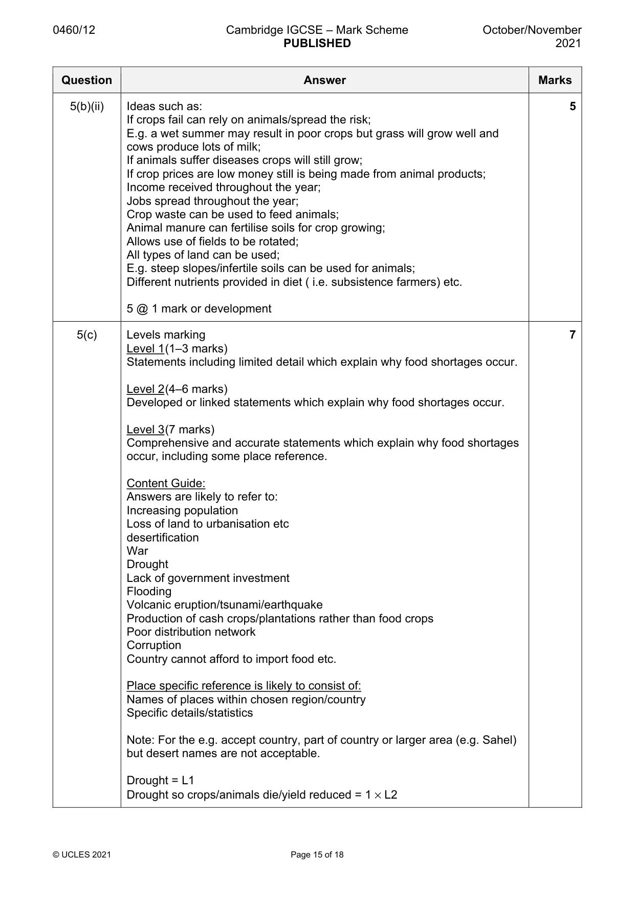
0460/12 Cambridge IGCSE – Mark Scheme PUBLISHED October/November 2021 © UCLES 2021 Page 15 of 18 Question Answer Marks 5(b)(ii) Ideas such as: If crops fail can rely on animals/spread the risk; E.g. a wet summer may result in poor crops but grass will grow well and cows produce lots of milk; If animals suffer diseases crops will still grow; If crop prices are low money still is being made from animal products; Income received throughout the year; Jobs spread throughout the year; Crop waste can be used to feed animals; Animal manure can fertilise soils for crop growing; Allows use of fields to be rotated; All types of land can be used; E.g. steep slopes/infertile soils can be used for animals; Different nutrients provided in diet ( i.e. subsistence farmers) etc. 5 @ 1 mark or development 5 5(c) Levels marking Level 1 (1–3 marks) Statements including limited detail which explain why food shortages occur. Level 2 (4–6 marks) Developed or linked statements which explain why food shortages occur. Level 3 (7 marks) Comprehensive and accurate statements which explain why food shortages occur, including some place reference. Content Guide: Answers are likely to refer to: Increasing population Loss of land to urbanisation etc desertification War Drought Lack of government investment Flooding Volcanic eruption/tsunami/earthquake Production of cash crops/plantations rather than food crops Poor distribution network Corruption Country cannot afford to import food etc. Place specific reference is likely to consist of: Names of places within chosen region/country Specific details/statistics Note: For the e.g. accept country, part of country or larger area (e.g. Sahel) but desert names are not acceptable. Drought = L1 Drought so crops/animals die/yield reduced = 1 × L2 7
Mark scheme, page 16
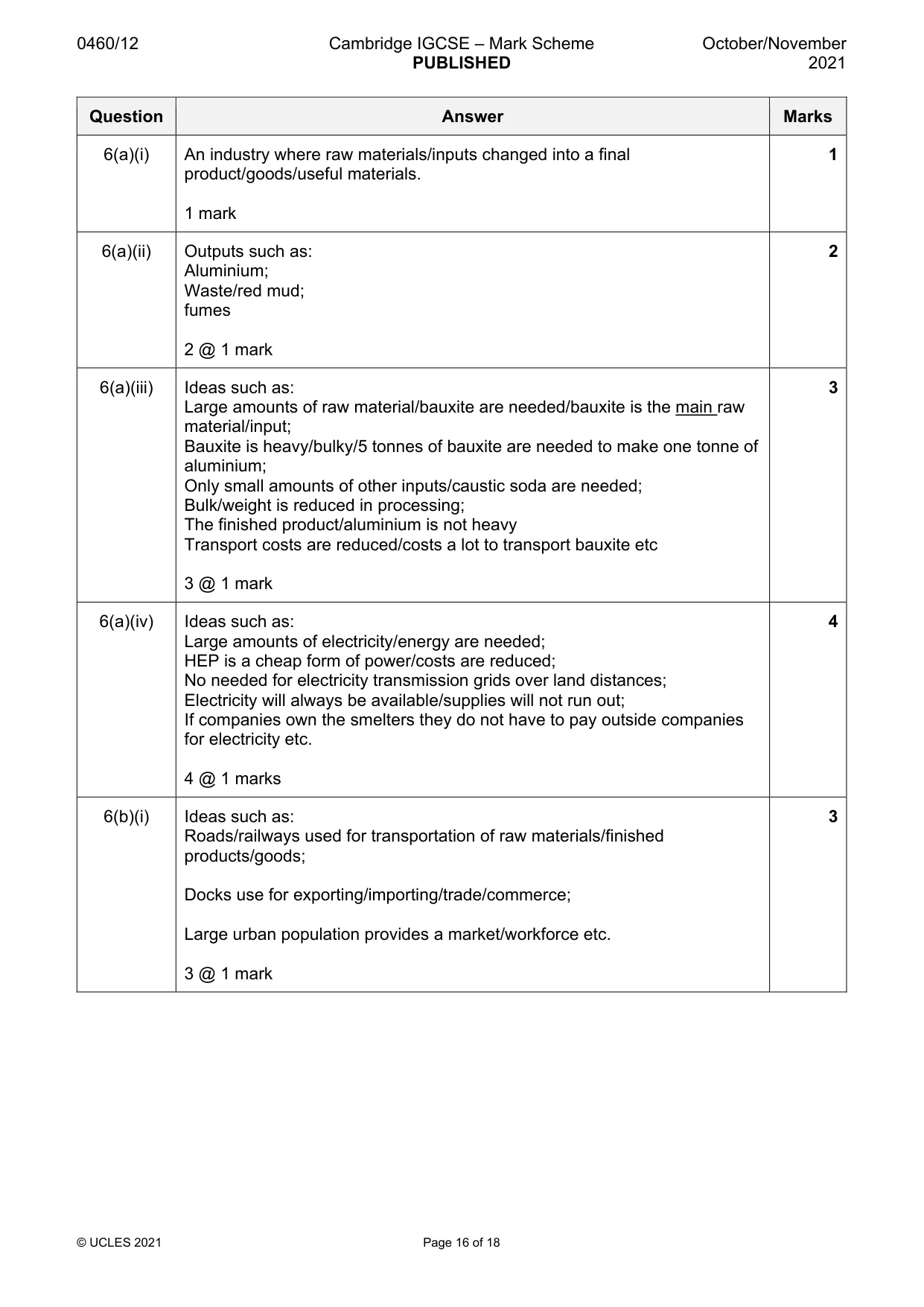
0460/12 Cambridge IGCSE – Mark Scheme PUBLISHED October/November 2021 © UCLES 2021 Page 16 of 18 Question Answer Marks 6(a)(i) An industry where raw materials/inputs changed into a final product/goods/useful materials. 1 mark 1 6(a)(ii) Outputs such as: Aluminium; Waste/red mud; fumes 2 @ 1 mark 2 6(a)(iii) Ideas such as: Large amounts of raw material/bauxite are needed/bauxite is the main raw material/input; Bauxite is heavy/bulky/5 tonnes of bauxite are needed to make one tonne of aluminium; Only small amounts of other inputs/caustic soda are needed; Bulk/weight is reduced in processing; The finished product/aluminium is not heavy Transport costs are reduced/costs a lot to transport bauxite etc 3 @ 1 mark 3 6(a)(iv) Ideas such as: Large amounts of electricity/energy are needed; HEP is a cheap form of power/costs are reduced; No needed for electricity transmission grids over land distances; Electricity will always be available/supplies will not run out; If companies own the smelters they do not have to pay outside companies for electricity etc. 4 @ 1 marks 4 6(b)(i) Ideas such as: Roads/railways used for transportation of raw materials/finished products/goods; Docks use for exporting/importing/trade/commerce; Large urban population provides a market/workforce etc. 3 @ 1 mark 3
Mark scheme, page 17
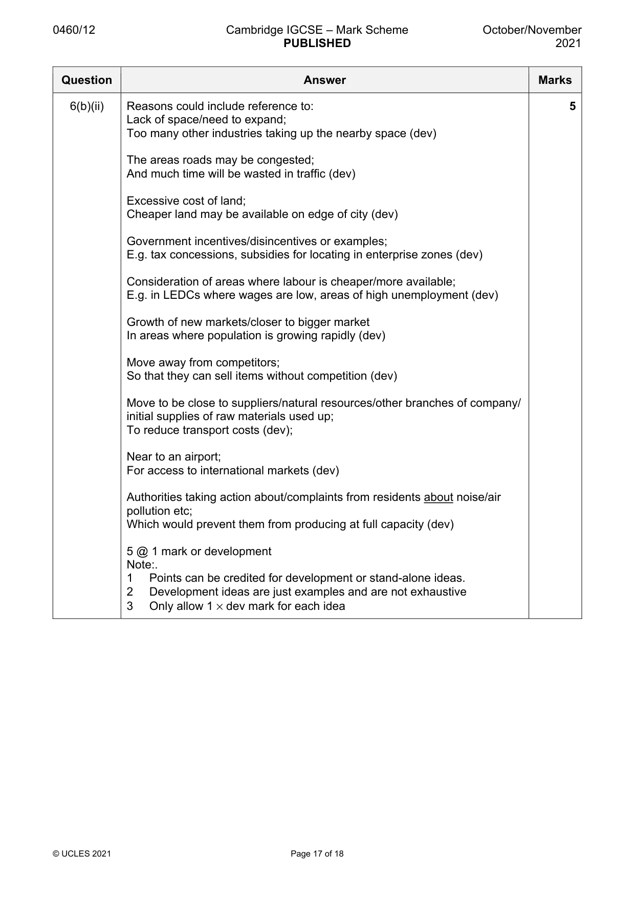
0460/12 Cambridge IGCSE – Mark Scheme PUBLISHED October/November 2021 © UCLES 2021 Page 17 of 18 Question Answer Marks 6(b)(ii) Reasons could include reference to: Lack of space/need to expand; Too many other industries taking up the nearby space (dev) The areas roads may be congested; And much time will be wasted in traffic (dev) Excessive cost of land; Cheaper land may be available on edge of city (dev) Government incentives/disincentives or examples; E.g. tax concessions, subsidies for locating in enterprise zones (dev) Consideration of areas where labour is cheaper/more available; E.g. in LEDCs where wages are low, areas of high unemployment (dev) Growth of new markets/closer to bigger market In areas where population is growing rapidly (dev) Move away from competitors; So that they can sell items without competition (dev) Move to be close to suppliers/natural resources/other branches of company/ initial supplies of raw materials used up; To reduce transport costs (dev); Near to an airport; For access to international markets (dev) Authorities taking action about/complaints from residents about noise/air pollution etc; Which would prevent them from producing at full capacity (dev) 5 @ 1 mark or development Note:. 1 Points can be credited for development or stand-alone ideas. 2 Development ideas are just examples and are not exhaustive 3 Only allow 1 × dev mark for each idea 5
Mark scheme, page 18
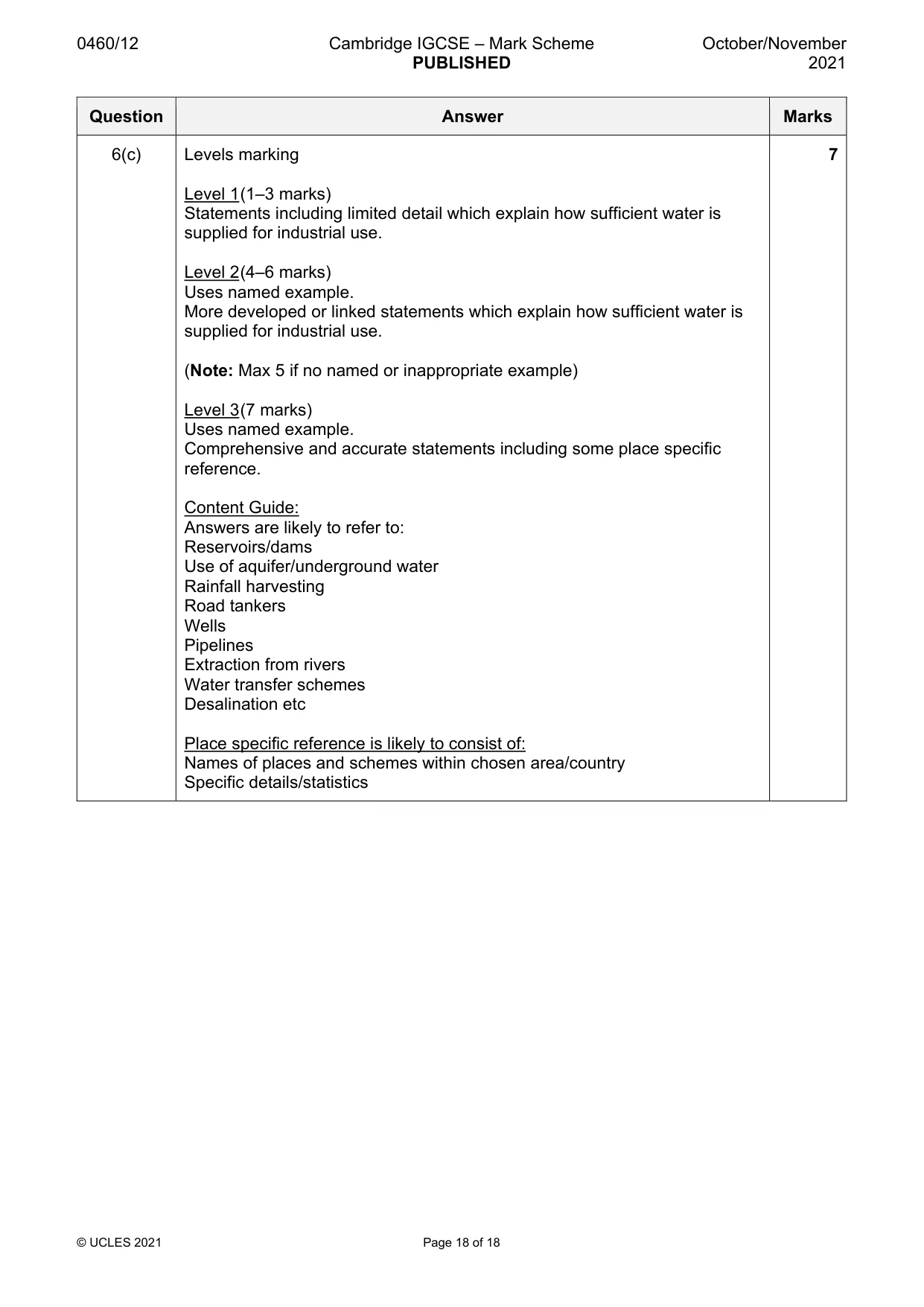
0460/12 Cambridge IGCSE – Mark Scheme PUBLISHED October/November 2021 © UCLES 2021 Page 18 of 18 Question Answer Marks 6(c) Levels marking Level 1 (1–3 marks) Statements including limited detail which explain how sufficient water is supplied for industrial use. Level 2 (4–6 marks) Uses named example. More developed or linked statements which explain how sufficient water is supplied for industrial use. (Note: Max 5 if no named or inappropriate example) Level 3 (7 marks) Uses named example. Comprehensive and accurate statements including some place specific reference. Content Guide: Answers are likely to refer to: Reservoirs/dams Use of aquifer/underground water Rainfall harvesting Road tankers Wells Pipelines Extraction from rivers Water transfer schemes Desalination etc Place specific reference is likely to consist of: Names of places and schemes within chosen area/country Specific details/statistics 7
What you needed in this session
Cambridge’s own grade thresholds for 2021 Oct/Nov, Paper 1 · Variant 2. A higher threshold means an easier paper — the bar moves with how the cohort did.