Cambridge IGCSE Geography 0460 — 2005 Oct/Nov Paper 1 · Variant 1
0460/11/O/N/05
The question paper and its mark scheme, free to read here and free to download. This is Cambridge’s own paper, exactly as it was sat.
Question paper16 pages



Mark scheme11 pages
Answers below. Sit the paper first if you are practising.
Paper as text
Question paper, page 1
This document consists of 13 printed pages, 3 blank pages and 1 insert. SPA (DR) S84485/4 © UCLES 2005 [Turn over UNIVERSITY OF CAMBRIDGE INTERNATIONAL EXAMINATIONS International General Certificate of Secondary Education GEOGRAPHY 0460/01 Paper 1 October/November 2005 1 hour 45 minutes Additional Materials: Answer Booklet/Paper READ THESE INSTRUCTIONS FIRST If you have been given an Answer Booklet, follow the instructions on the front cover of the Booklet. Write your Centre number, candidate number and name on all the work you hand in. Write in dark blue or black pen on both sides of the paper. You may use a soft pencil for any diagrams, graphs or rough working. Do not use staples, paper clips, highlighters, glue or correction fluid. Answer three questions. At the end of the examination, fasten all your work securely together. The number of marks is given in brackets [ ] at the end of each question or part question. Sketch maps and diagrams should be drawn whenever they serve to illustrate an answer. The insert contains Photograph A for Question 4 and Figures 10A and 10B for Question 6. www.XtremePapers.com
Question paper, page 2
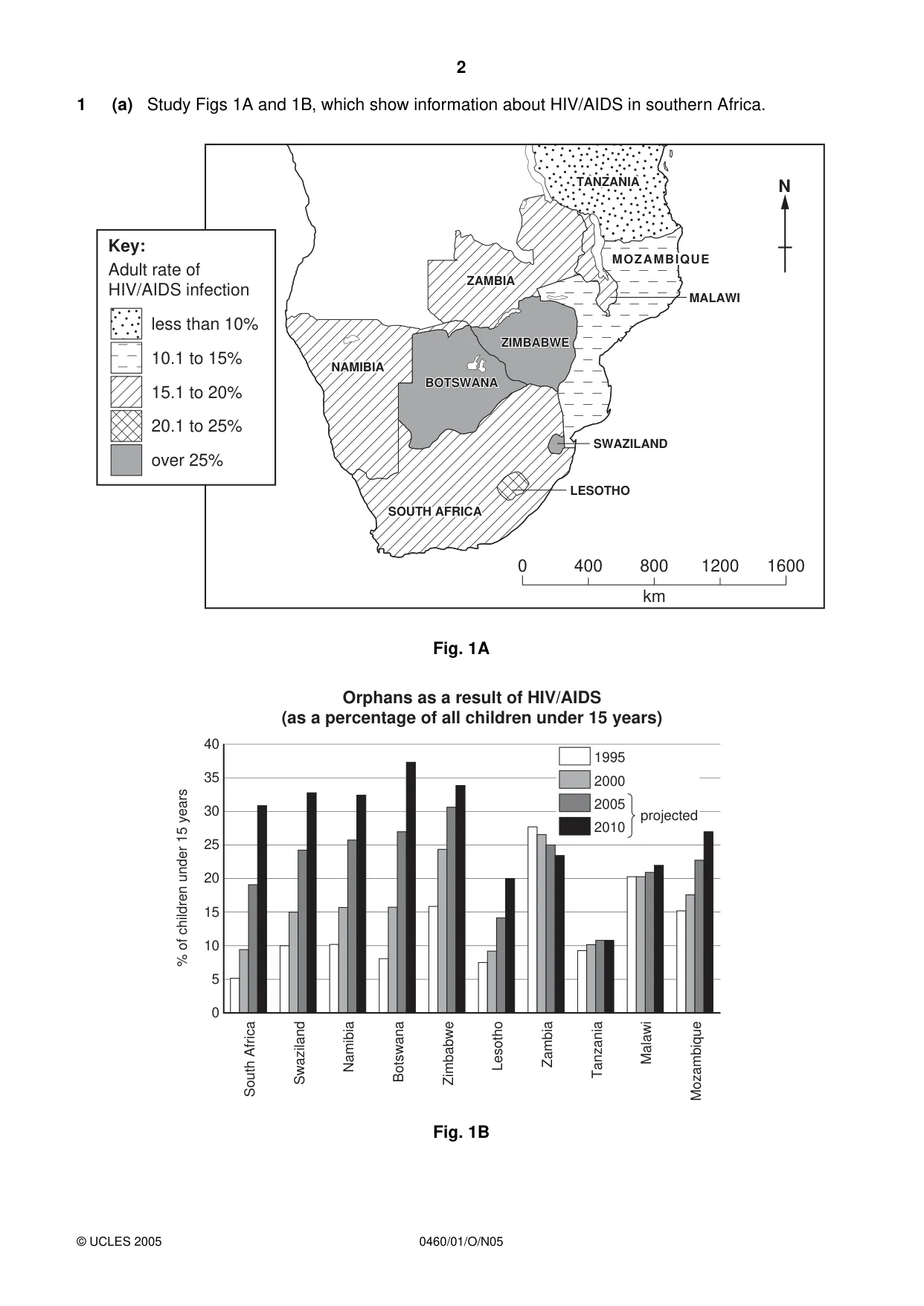
2 0460/01/O/N05 1 (a) Study Figs 1A and 1B, which show information about HIV/AIDS in southern Africa. Fig. 1A Fig. 1B 1995 2000 2005 2010 projected Orphans as a result of HIV/AIDS (as a percentage of all children under 15 years) 40 35 30 25 20 15 10 5 0 % of children under 15 years South Africa Swaziland Namibia Botswana Zimbabwe Lesotho Zambia Tanzania Malawi Mozambique 0 400 800 km 1200 1600 BOTSWANA BOTSWANA ZIMBABWE ZIMBABWE MOZAMBIQUE MOZAMBIQUE NAMIBIA NAMIBIA SOUTH AFRICA SOUTH AFRICA TANZANIA TANZANIA ZAMBIA ZAMBIA MOZAMBIQUE NAMIBIA SOUTH AFRICA TANZANIA BOTSWANA ZAMBIA SWAZILAND LESOTHO MALAWI ZIMBABWE N Key: Adult rate of HIV/AIDS infection less than 10% 10.1 to 15% 15.1 to 20% 20.1 to 25% over 25% © UCLES 2005
Question paper, page 3
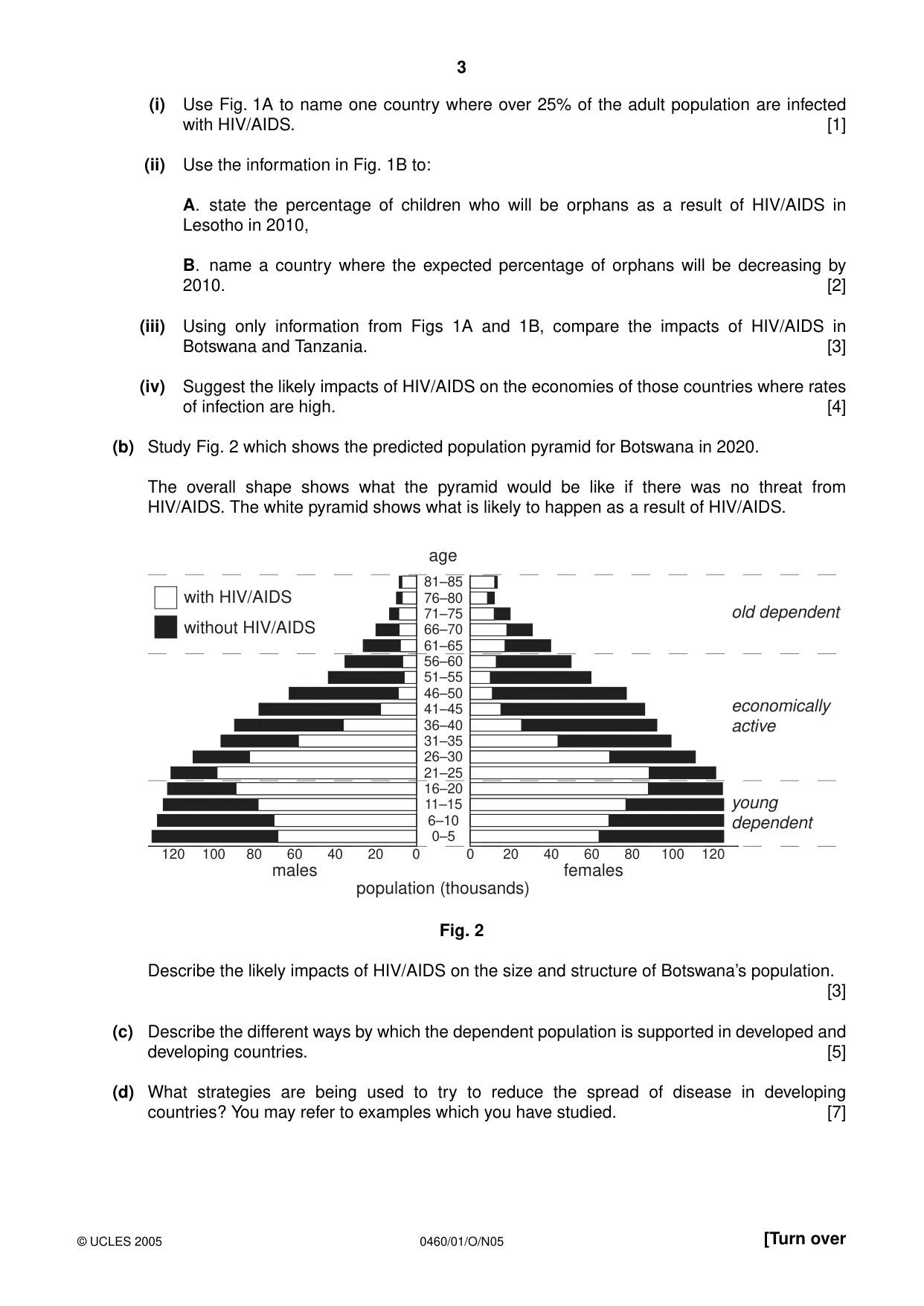
3 0460/01/O/N05 [Turn over (i) Use Fig. 1A to name one country where over 25% of the adult population are infected with HIV/AIDS. [1] (ii) Use the information in Fig. 1B to: A. state the percentage of children who will be orphans as a result of HIV/AIDS in Lesotho in 2010, B. name a country where the expected percentage of orphans will be decreasing by 2010. [2] (iii) Using only information from Figs 1A and 1B, compare the impacts of HIV/AIDS in Botswana and Tanzania. [3] (iv) Suggest the likely impacts of HIV/AIDS on the economies of those countries where rates of infection are high. [4] (b) Study Fig. 2 which shows the predicted population pyramid for Botswana in 2020. The overall shape shows what the pyramid would be like if there was no threat from HIV/AIDS. The white pyramid shows what is likely to happen as a result of HIV/AIDS. Fig. 2 Describe the likely impacts of HIV/AIDS on the size and structure of Botswana’s population. [3] (c) Describe the different ways by which the dependent population is supported in developed and developing countries. [5] (d) What strategies are being used to try to reduce the spread of disease in developing countries? You may refer to examples which you have studied. [7] population (thousands) age 81–85 76–80 71–75 66–70 61–65 56–60 51–55 46–50 41–45 36–40 31–35 26–30 21–25 16–20 11–15 6–10 0–5 females males 120 100 80 60 40 20 0 0 20 40 60 80 100 120 old dependent economically active young dependent with HIV/AIDS without HIV/AIDS © UCLES 2005
Question paper, page 4
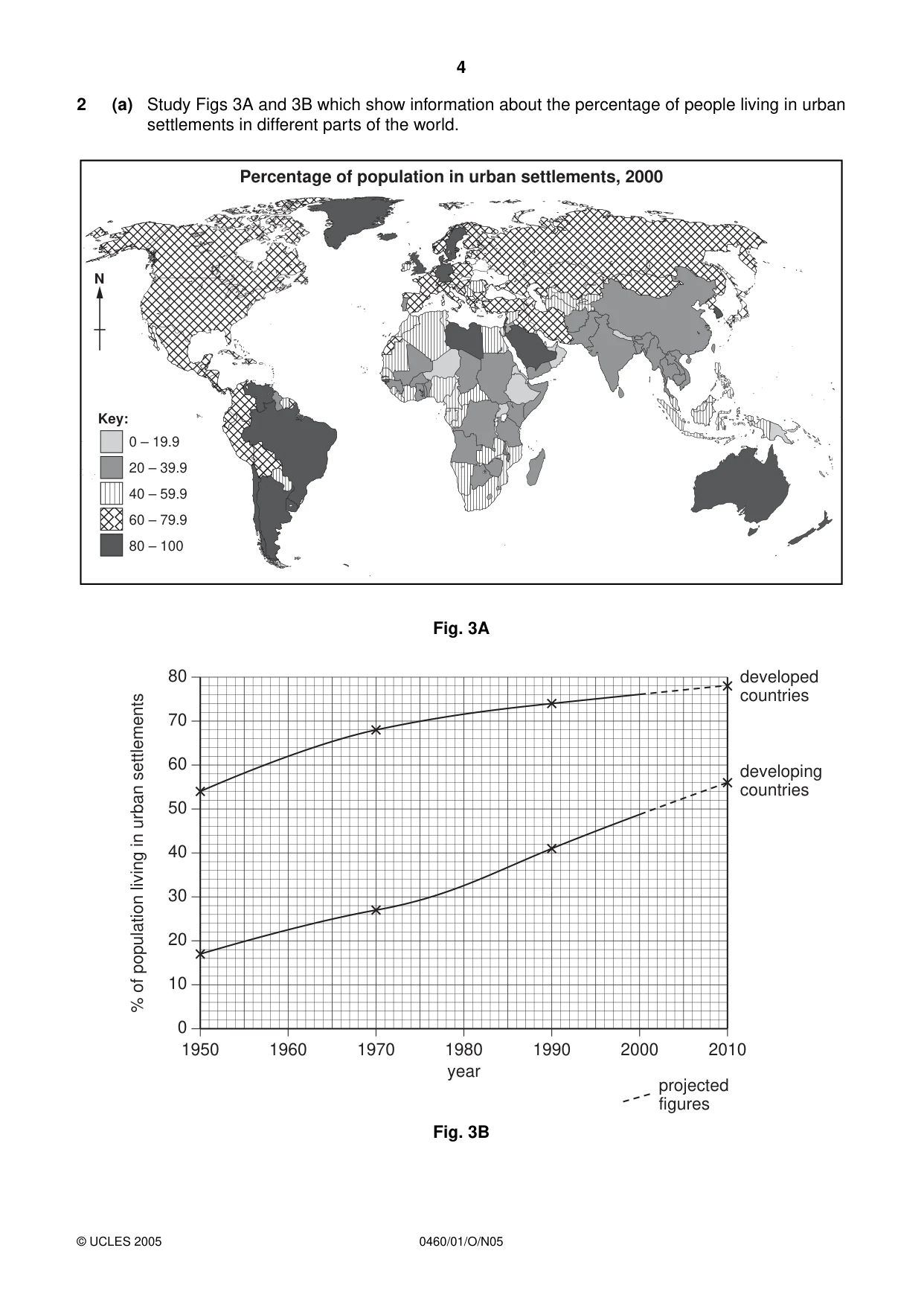
4 0460/01/O/N05 2 (a) Study Figs 3A and 3B which show information about the percentage of people living in urban settlements in different parts of the world. Fig. 3A Fig. 3B 80 70 60 50 40 30 20 10 0 1950 1960 1970 1980 1990 2000 2010 year % of population living in urban settlements developed countries developing countries projected figures Key: 0 – 19.9 20 – 39.9 40 – 59.9 60 – 79.9 80 – 100 N Percentage of population in urban settlements, 2000 © UCLES 2005
Question paper, page 5
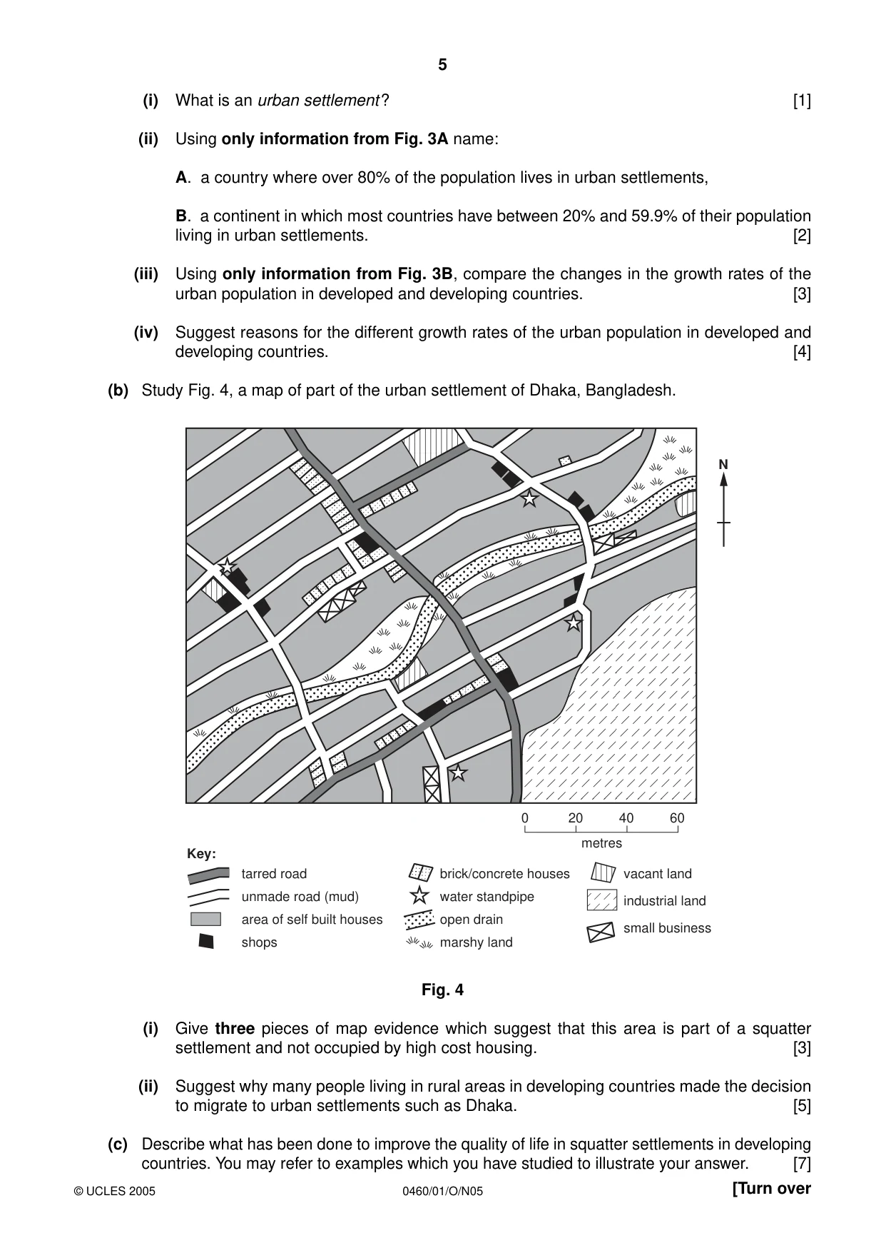
5 0460/01/O/N05 [Turn over (i) What is an urban settlement? [1] (ii) Using only information from Fig. 3A name: A. a country where over 80% of the population lives in urban settlements, B. a continent in which most countries have between 20% and 59.9% of their population living in urban settlements. [2] (iii) Using only information from Fig. 3B, compare the changes in the growth rates of the urban population in developed and developing countries. [3] (iv) Suggest reasons for the different growth rates of the urban population in developed and developing countries. [4] (b) Study Fig. 4, a map of part of the urban settlement of Dhaka, Bangladesh. Fig. 4 (i) Give three pieces of map evidence which suggest that this area is part of a squatter settlement and not occupied by high cost housing. [3] (ii) Suggest why many people living in rural areas in developing countries made the decision to migrate to urban settlements such as Dhaka. [5] (c) Describe what has been done to improve the quality of life in squatter settlements in developing countries. You may refer to examples which you have studied to illustrate your answer. [7] metres 0 20 40 60 N Key: tarred road unmade road (mud) area of self built houses shops brick/concrete houses water standpipe open drain marshy land vacant land industrial land small business © UCLES 2005
Question paper, page 6
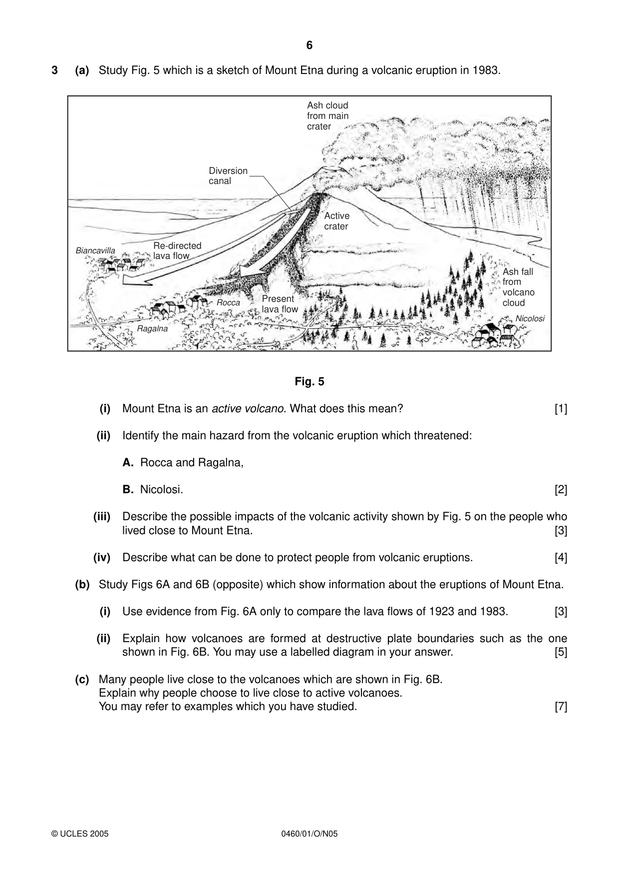
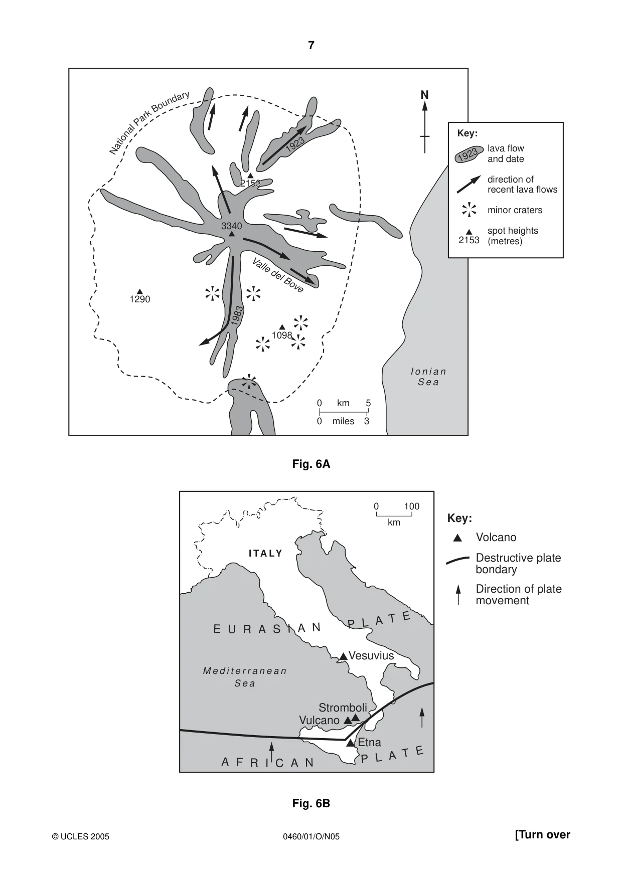
6 0460/01/O/N05 3 (a) Study Fig. 5 which is a sketch of Mount Etna during a volcanic eruption in 1983. Fig. 5 (i) Mount Etna is an active volcano. What does this mean? [1] (ii) Identify the main hazard from the volcanic eruption which threatened: A. Rocca and Ragalna, B. Nicolosi. [2] (iii) Describe the possible impacts of the volcanic activity shown by Fig. 5 on the people who lived close to Mount Etna. [3] (iv) Describe what can be done to protect people from volcanic eruptions. [4] (b) Study Figs 6A and 6B (opposite) which show information about the eruptions of Mount Etna. (i) Use evidence from Fig. 6A only to compare the lava flows of 1923 and 1983. [3] (ii) Explain how volcanoes are formed at destructive plate boundaries such as the one shown in Fig. 6B. You may use a labelled diagram in your answer. [5] (c) Many people live close to the volcanoes which are shown in Fig. 6B. Explain why people choose to live close to active volcanoes. You may refer to examples which you have studied. [7] Ash cloud from main crater Ash fall from volcano cloud Diversion canal Re-directed lava flow Biancavilla Ragalna Rocca Nicolosi Active crater Present lava flow © UCLES 2005
Question paper, page 7
7 0460/01/O/N05 [Turn over Fig. 6A Fig. 6B E U R A S I A N P L A T E A F R I C A N P L A T E M e d i t e r r a n e a n S e a I TA LY Vesuvius Stromboli Vulcano Etna 0 100 km Key: Volcano Destructive plate bondary Direction of plate movement 1290 3340 1098 2153 2153 2153 1923 1983 Valle del Bove N at io na l P ar k B ou nd ar y I o n i a n S e a N 0 0 5 km 3 miles 1923 2153 lava flow and date direction of recent lava flows minor craters spot heights (metres) Key: © UCLES 2005
Question paper, page 8
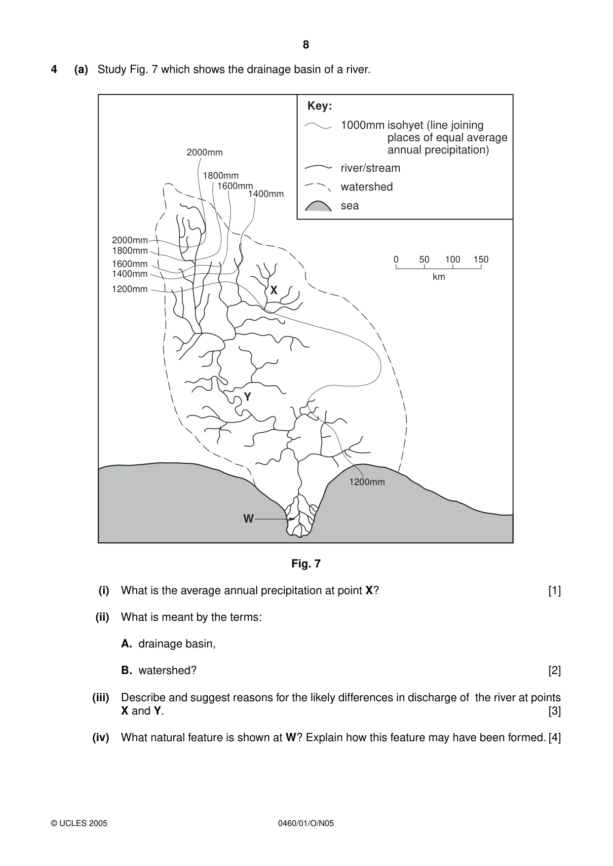
8 0460/01/O/N05 4 (a) Study Fig. 7 which shows the drainage basin of a river. Fig. 7 (i) What is the average annual precipitation at point X? [1] (ii) What is meant by the terms: A. drainage basin, B. watershed? [2] (iii) Describe and suggest reasons for the likely differences in discharge of the river at points X and Y. [3] (iv) What natural feature is shown at W? Explain how this feature may have been formed. [4] Y X W 2000mm 2000mm 1800mm 1800mm 1600mm 1600mm 1400mm 1400mm 1200mm 1200mm Key: 1000mm river/stream watershed sea isohyet (line joining places of equal average annual precipitation) 0 50 100 150 km © UCLES 2005
Question paper, page 9
9 0460/01/O/N05 [Turn over (b) Study Photograph A (Insert) which shows an upland river and its valley. (i) Describe the main features of the river and valley which are shown in Photograph A. [3] (ii) Explain how natural processes of weathering and erosion shape river valleys such as the one shown in Photograph A. You may use labelled diagrams in your answer. [5] (c) Many people live and work on the flood plains of major rivers. Describe the advantages and difficulties for people of living on the flood plain of a river. You may refer to examples which you have studied. [7] © UCLES 2005
Question paper, page 10
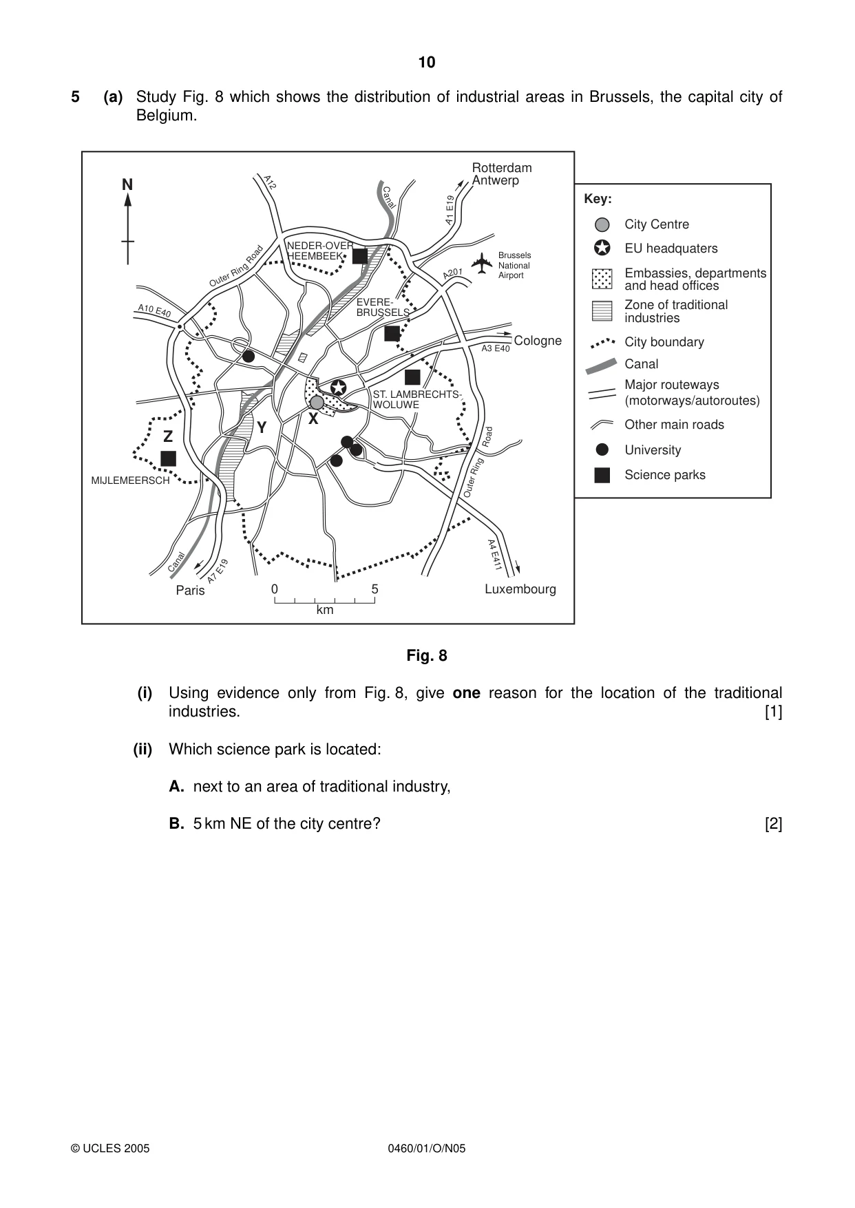
10 0460/01/O/N05 5 (a) Study Fig. 8 which shows the distribution of industrial areas in Brussels, the capital city of Belgium. Fig. 8 (i) Using evidence only from Fig. 8, give one reason for the location of the traditional industries. [1] (ii) Which science park is located: A. next to an area of traditional industry, B. 5 km NE of the city centre? [2] 0 5 km N Ou ter R i n g Road A 10 E4 0 A 7 E 1 9 A4 E411 Outer R ing R o a d A3 E 40 A 2 0 1 A 1 E 1 9 C a n al C an al A12 NEDER-OVER HEEMBEEK EVERE- BRUSSELS ST. LAMBRECHTS- WOLUWE MIJLEMEERSCH Z Y X Rotterdam Antwerp Cologne Luxembourg Brussels National Airport Paris Key: City Centre EU headquaters Embassies, departments and head offices Zone of traditional industries City boundary Canal Major routeways (motorways/autoroutes) Other main roads Science parks University © UCLES 2005
Question paper, page 11
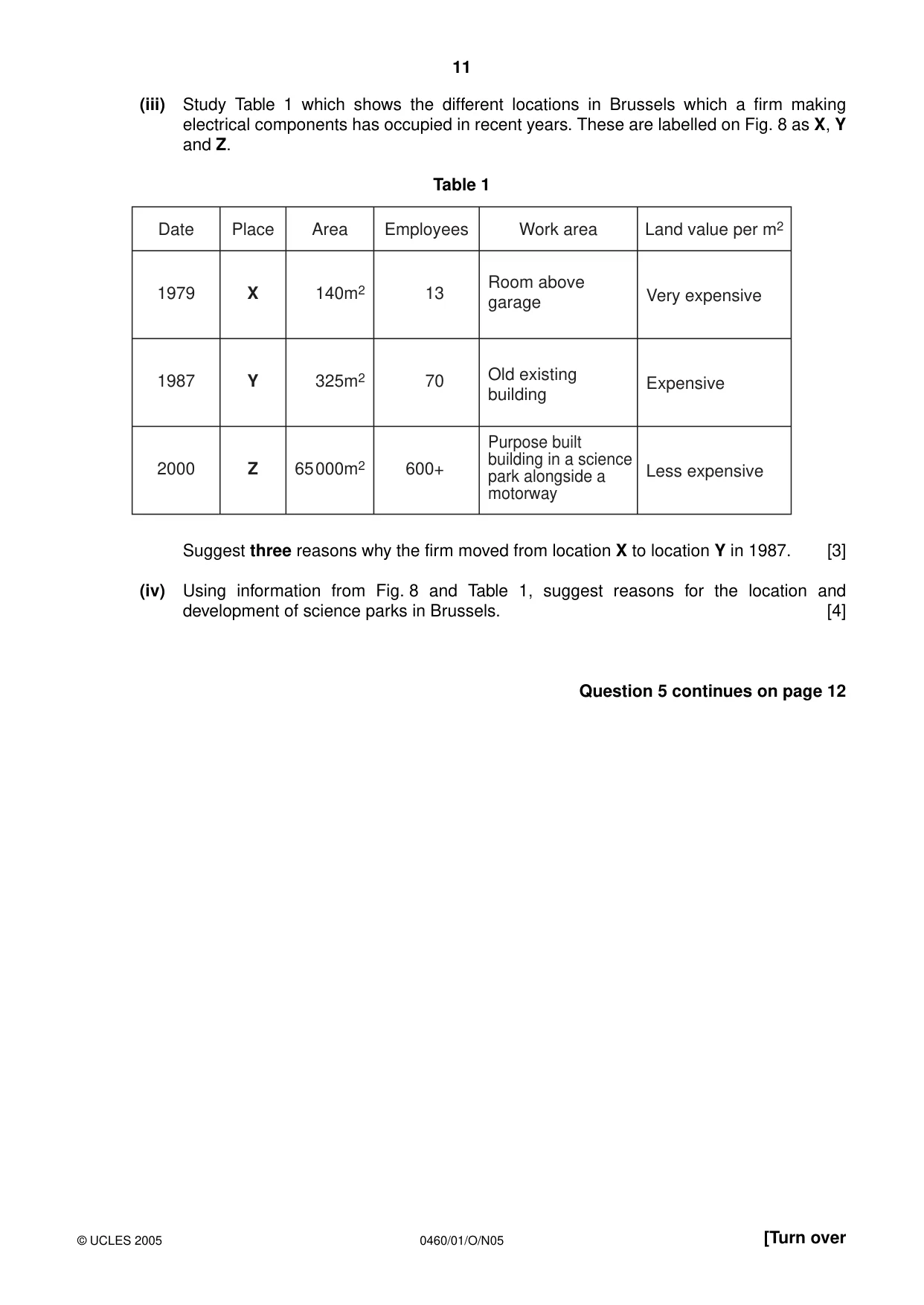
11 0460/01/O/N05 [Turn over (iii) Study Table 1 which shows the different locations in Brussels which a firm making electrical components has occupied in recent years. These are labelled on Fig. 8 as X, Y and Z. Table 1 Suggest three reasons why the firm moved from location X to location Y in 1987. [3] (iv) Using information from Fig. 8 and Table 1, suggest reasons for the location and development of science parks in Brussels. [4] Question 5 continues on page 12 Date Place Area Employees Work area Land value per m2 1979 1987 2000 X Y Z 140m2 325m2 65000m2 13 70 600+ Room above garage Very expensive Expensive Less expensive Old existing building Purpose built building in a science park alongside a motorway © UCLES 2005
Question paper, page 12
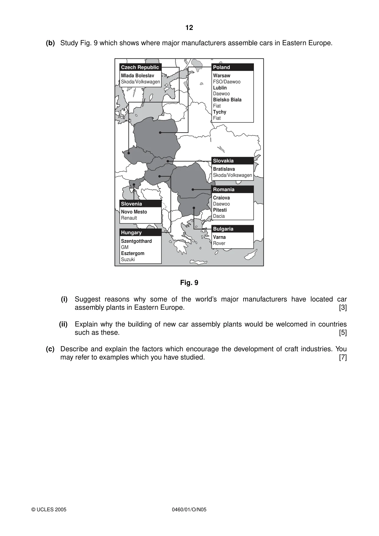
12 0460/01/O/N05 (b) Study Fig. 9 which shows where major manufacturers assemble cars in Eastern Europe. Fig. 9 (i) Suggest reasons why some of the world’s major manufacturers have located car assembly plants in Eastern Europe. [3] (ii) Explain why the building of new car assembly plants would be welcomed in countries such as these. [5] (c) Describe and explain the factors which encourage the development of craft industries. You may refer to examples which you have studied. [7] Poland Warsaw FSO/Daewoo Lublin Daewoo Bielsko Biala Fiat Tychy Fiat Slovakia Bratislava Skoda/Volkswagen Bulgaria Varna Rover Romania Craiova Daewoo Pitesti Dacia Czech Republic Mlada Boleslav Skoda/Volkswagen Slovenia Novo Mesto Renault Hungary Szentgotthard GM Esztergom Suzuki © UCLES 2005
Question paper, page 13
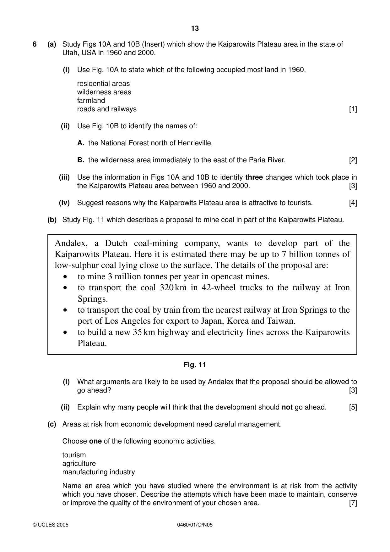
13 0460/01/O/N05 6 (a) Study Figs 10A and 10B (Insert) which show the Kaiparowits Plateau area in the state of Utah, USA in 1960 and 2000. (i) Use Fig. 10A to state which of the following occupied most land in 1960. residential areas wilderness areas farmland roads and railways [1] (ii) Use Fig. 10B to identify the names of: A. the National Forest north of Henrieville, B. the wilderness area immediately to the east of the Paria River. [2] (iii) Use the information in Figs 10A and 10B to identify three changes which took place in the Kaiparowits Plateau area between 1960 and 2000. [3] (iv) Suggest reasons why the Kaiparowits Plateau area is attractive to tourists. [4] (b) Study Fig. 11 which describes a proposal to mine coal in part of the Kaiparowits Plateau. Fig. 11 (i) What arguments are likely to be used by Andalex that the proposal should be allowed to go ahead? [3] (ii) Explain why many people will think that the development should not go ahead. [5] (c) Areas at risk from economic development need careful management. Choose one of the following economic activities. tourism agriculture manufacturing industry Name an area which you have studied where the environment is at risk from the activity which you have chosen. Describe the attempts which have been made to maintain, conserve or improve the quality of the environment of your chosen area. [7] © UCLES 2005 Andalex, a Dutch coal-mining company, wants to develop part of the Kaiparowits Plateau. Here it is estimated there may be up to 7 billion tonnes of low-sulphur coal lying close to the surface. The details of the proposal are: • to mine 3 million tonnes per year in opencast mines. • to transport the coal 320km in 42-wheel trucks to the railway at Iron Springs. • to transport the coal by train from the nearest railway at Iron Springs to the port of Los Angeles for export to Japan, Korea and Taiwan. • to build a new 35km highway and electricity lines across the Kaiparowits Plateau.
Question paper, page 16
16 0460/01/O/N05 BLANK PAGE Copyright Acknowledgements: Question 1 Graphs © Philip Allen Publishers, ‘Geography Review’, Jan 2003. Question 2 © The Geographical Association, 2000. Question 2 Fig. 3a © The Geographical Association, 2000, ‘Geography Magazine Millenium Special’. Question 3 © Philip Allen (2003), ‘Geography Review’. Question 3 Fig. 5 ‘Natural Systems and Human Responses’, R Prosser. Published by Thomas Nelson & Sons © Nelson Thornes Ltd. Question 5 Fig. 9 Heinemann Educational (2002). ‘Geography Matters Book 3: Teachers Resource Pack’. Question 6 © Philip Allen (1997), ‘Geographical Review’. Permission to reproduce items where third-party owned material protected by copyright is included has been sought and cleared where possible. Every reasonable effort has been made by the publisher (UCLES) to trace copyright holders, but if any items requiring clearance have unwittingly been included, the publisher will be pleased to make amends at the earliest possible opportunity. University of Cambridge International Examinations is part of the University of Cambridge Local Examinations Syndicate (UCLES), which is itself a department of the University of Cambridge.
Mark scheme, page 1
UNIVERSITY OF CAMBRIDGE INTERNATIONAL EXAMINATIONS International General Certificate of Secondary Education MARK SCHEME for the November 2005 question paper 0460 GEOGRAPHY 0460/01 Paper 1 maximum raw mark 75 This mark scheme is published as an aid to teachers and students, to indicate the requirements of the examination. It shows the basis on which Examiners were initially instructed to award marks. It does not indicate the details of the discussions that took place at an Examiners’ meeting before marking began. Any substantial changes to the mark scheme that arose from these discussions will be recorded in the published Report on the Examination. All Examiners are instructed that alternative correct answers and unexpected approaches in candidates’ scripts must be given marks that fairly reflect the relevant knowledge and skills demonstrated. Mark schemes must be read in conjunction with the question papers and the Report on the Examination. The minimum marks in these components needed for various grades were previously published with these mark schemes, but are now instead included in the Report on the Examination for this session. • CIE will not enter into discussion or correspondence in connection with these mark schemes. CIE is publishing the mark schemes for the November 2005 question papers for most IGCSE and GCE Advanced Level and Advanced Subsidiary Level syllabuses and some Ordinary Level syllabuses. www.XtremePapers.com
Mark scheme, page 2
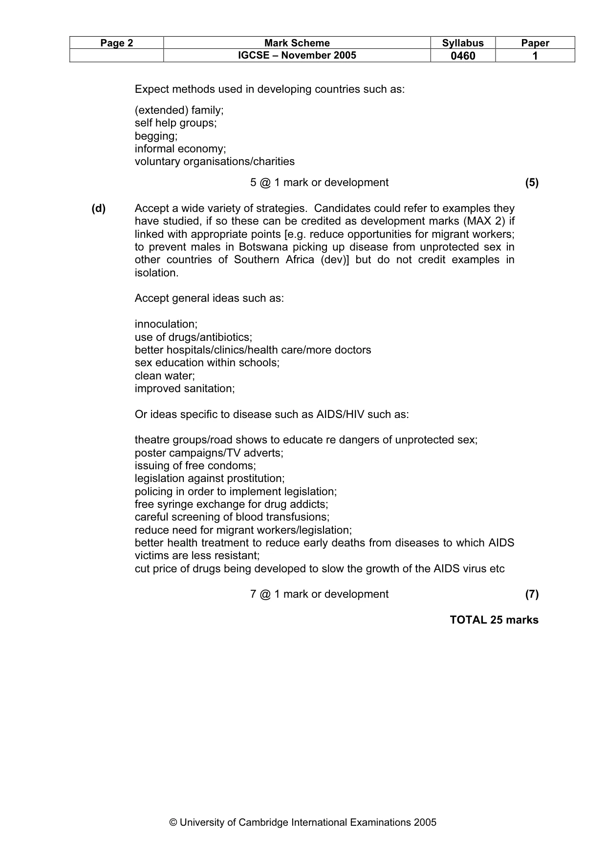
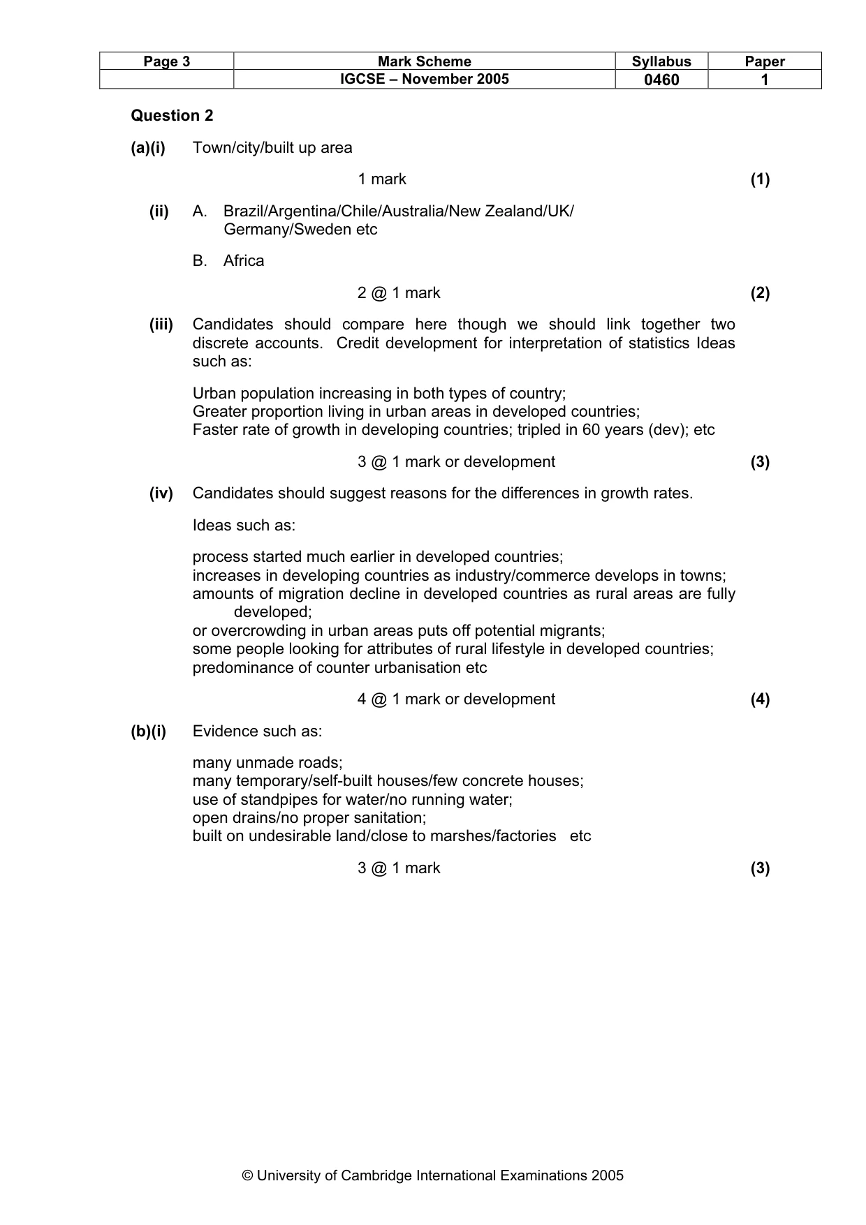
Page 1 Mark Scheme Syllabus Paper IGCSE – November 2005 0460 1 © University of Cambridge International Examinations 2005 Question 1 (a)(i) Swaziland/Botswana/Zimbabwe 1 mark (1) (ii) A. 20 B. Zambia 2 @ 1 mark (2) (iii) Candidates should be able to compare the two countries here though we should link together two discrete accounts. Ideas such as: rates of infection higher in Botswana/lower in Tanzania; percentage of orphans higher in Botswana/lower in Tanzania; percentage of orphans increasing more rapidly in Botswana; HIV/AIDS is a serious issue in both countries etc (N.B. Allow figures which could be used as alternatives to statements or as development marks) 3 @ 1 mark (3) (iv) Credit references only for impact on economy such as: economy will fall/decline/be damaged reduces productive capacity of individuals/people cannot work reduces levels of food produced; requires much investment in health care; which prevents investment in other aspects of development; discourages development of (tourism, industry etc) discourages foreign investment etc 4 @ 1 mark or development (4) (b) Credit references only for impact on population size and structure. Credit development for interpretation of statistics. Ideas such as: reduction in total size of population; almost halved (dev); large reduction in 40-60 year old age group; reduced to about 10% of what it would have been without AIDS (dev); large reduction of 0 to 10 age group; approx halved (dev); slightly greater impact on female population etc dependency rate increased etc 3 @ 1 mark or development (3) (c) Candidates should describe the ways in which the dependent population is supported in both developed and developing countries. Credit up to 3 MAXIMUM for developed/developing countries. Expect methods used in developed countries such as: By taxation/state; Pensions; Family benefits; Health care; Welfare services; Sheltered housing/old peoples homes; State education/free education etc
Mark scheme, page 3
Page 2 Mark Scheme Syllabus Paper IGCSE – November 2005 0460 1 © University of Cambridge International Examinations 2005 Expect methods used in developing countries such as: (extended) family; self help groups; begging; informal economy; voluntary organisations/charities 5 @ 1 mark or development (5) (d) Accept a wide variety of strategies. Candidates could refer to examples they have studied, if so these can be credited as development marks (MAX 2) if linked with appropriate points [e.g. reduce opportunities for migrant workers; to prevent males in Botswana picking up disease from unprotected sex in other countries of Southern Africa (dev)] but do not credit examples in isolation. Accept general ideas such as: innoculation; use of drugs/antibiotics; better hospitals/clinics/health care/more doctors sex education within schools; clean water; improved sanitation; Or ideas specific to disease such as AIDS/HIV such as: theatre groups/road shows to educate re dangers of unprotected sex; poster campaigns/TV adverts; issuing of free condoms; legislation against prostitution; policing in order to implement legislation; free syringe exchange for drug addicts; careful screening of blood transfusions; reduce need for migrant workers/legislation; better health treatment to reduce early deaths from diseases to which AIDS victims are less resistant; cut price of drugs being developed to slow the growth of the AIDS virus etc 7 @ 1 mark or development (7) TOTAL 25 marks
Mark scheme, page 4
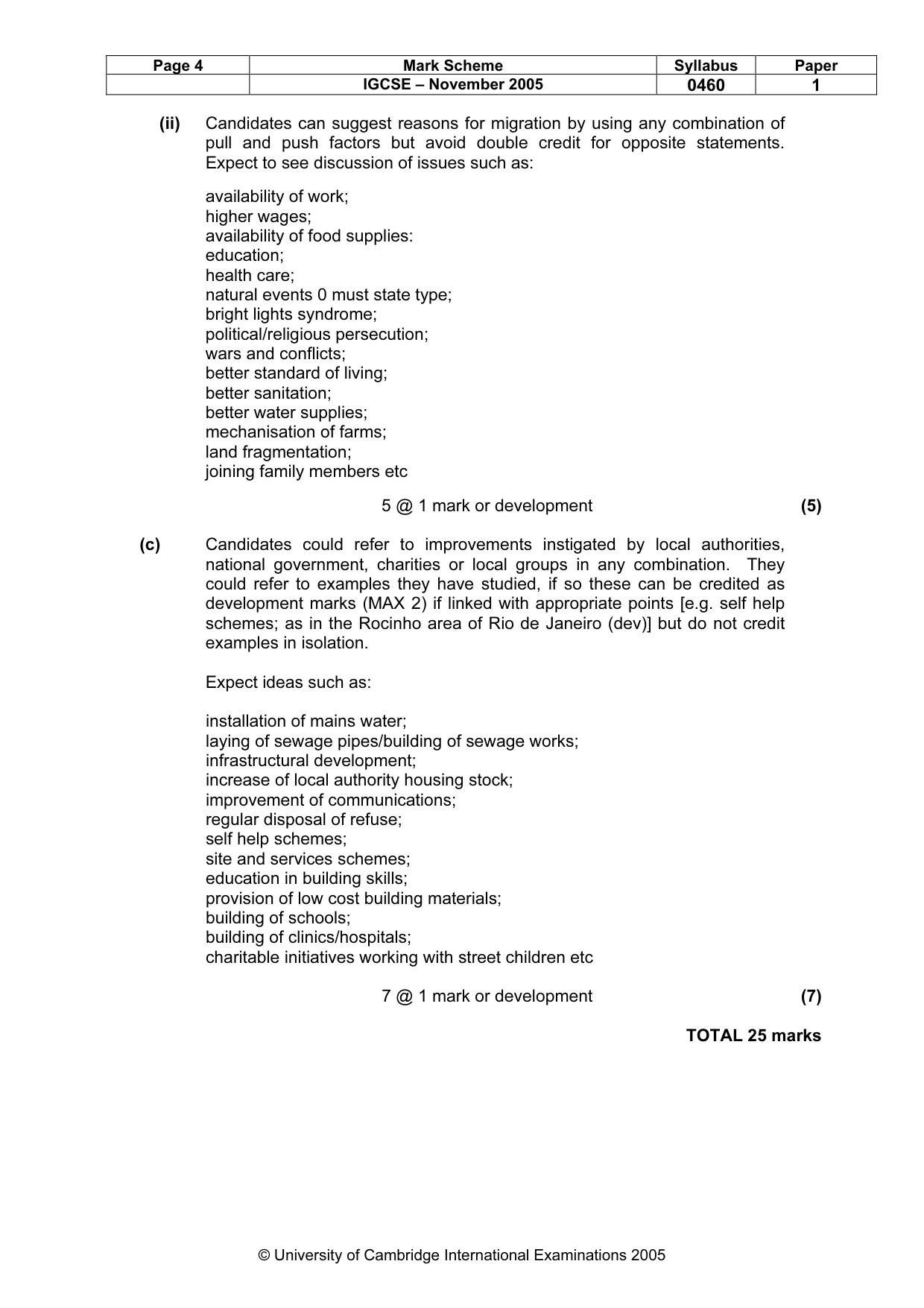
Page 3 Mark Scheme Syllabus Paper IGCSE – November 2005 0460 1 © University of Cambridge International Examinations 2005 Question 2 (a)(i) Town/city/built up area 1 mark (1) (ii) A. Brazil/Argentina/Chile/Australia/New Zealand/UK/ Germany/Sweden etc B. Africa 2 @ 1 mark (2) (iii) Candidates should compare here though we should link together two discrete accounts. Credit development for interpretation of statistics Ideas such as: Urban population increasing in both types of country; Greater proportion living in urban areas in developed countries; Faster rate of growth in developing countries; tripled in 60 years (dev); etc 3 @ 1 mark or development (3) (iv) Candidates should suggest reasons for the differences in growth rates. Ideas such as: process started much earlier in developed countries; increases in developing countries as industry/commerce develops in towns; amounts of migration decline in developed countries as rural areas are fully developed; or overcrowding in urban areas puts off potential migrants; some people looking for attributes of rural lifestyle in developed countries; predominance of counter urbanisation etc 4 @ 1 mark or development (4) (b)(i) Evidence such as: many unmade roads; many temporary/self-built houses/few concrete houses; use of standpipes for water/no running water; open drains/no proper sanitation; built on undesirable land/close to marshes/factories etc 3 @ 1 mark (3)
Mark scheme, page 5
Page 4 Mark Scheme Syllabus Paper IGCSE – November 2005 0460 1 © University of Cambridge International Examinations 2005 (ii) Candidates can suggest reasons for migration by using any combination of pull and push factors but avoid double credit for opposite statements. Expect to see discussion of issues such as: availability of work; higher wages; availability of food supplies: education; health care; natural events 0 must state type; bright lights syndrome; political/religious persecution; wars and conflicts; better standard of living; better sanitation; better water supplies; mechanisation of farms; land fragmentation; joining family members etc 5 @ 1 mark or development (5) (c) Candidates could refer to improvements instigated by local authorities, national government, charities or local groups in any combination. They could refer to examples they have studied, if so these can be credited as development marks (MAX 2) if linked with appropriate points [e.g. self help schemes; as in the Rocinho area of Rio de Janeiro (dev)] but do not credit examples in isolation. Expect ideas such as: installation of mains water; laying of sewage pipes/building of sewage works; infrastructural development; increase of local authority housing stock; improvement of communications; regular disposal of refuse; self help schemes; site and services schemes; education in building skills; provision of low cost building materials; building of schools; building of clinics/hospitals; charitable initiatives working with street children etc 7 @ 1 mark or development (7) TOTAL 25 marks
Mark scheme, page 6
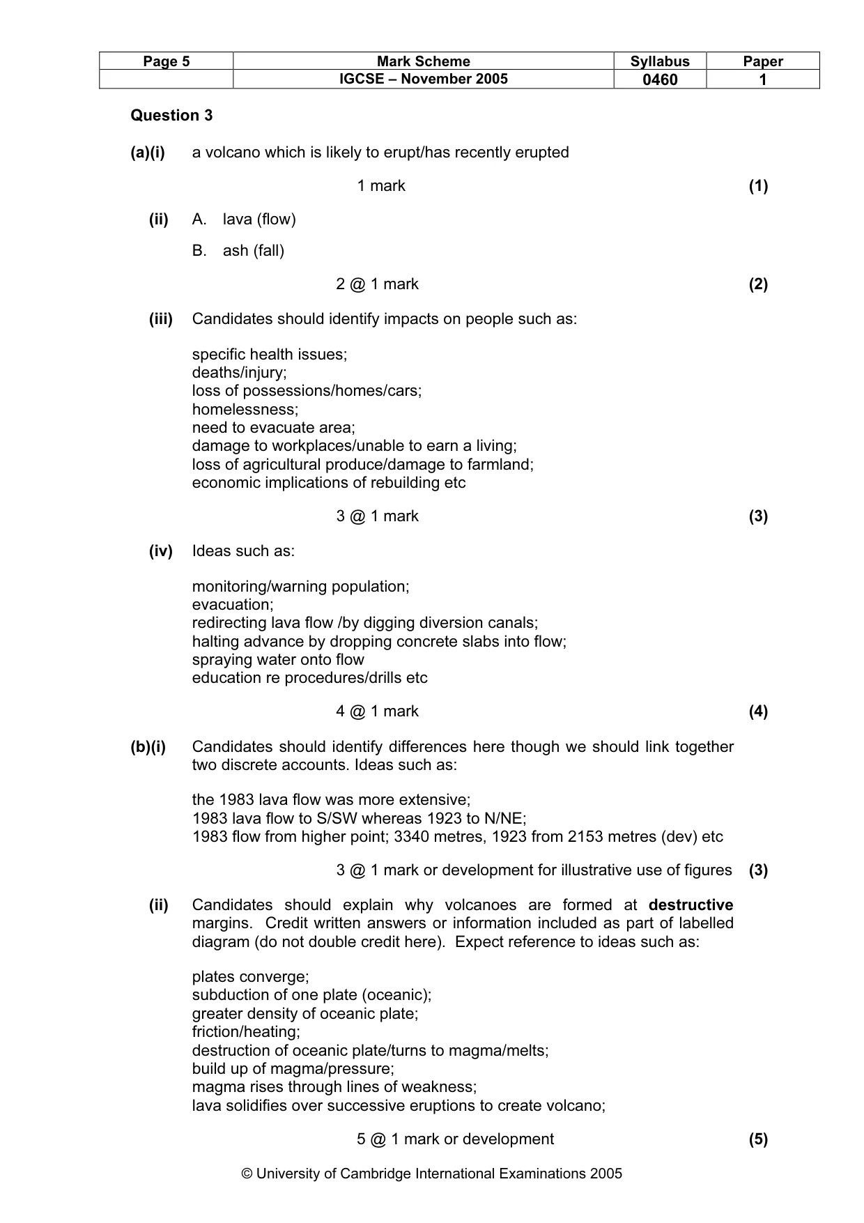
Page 5 Mark Scheme Syllabus Paper IGCSE – November 2005 0460 1 © University of Cambridge International Examinations 2005 Question 3 (a)(i) a volcano which is likely to erupt/has recently erupted 1 mark (1) (ii) A. lava (flow) B. ash (fall) 2 @ 1 mark (2) (iii) Candidates should identify impacts on people such as: specific health issues; deaths/injury; loss of possessions/homes/cars; homelessness; need to evacuate area; damage to workplaces/unable to earn a living; loss of agricultural produce/damage to farmland; economic implications of rebuilding etc 3 @ 1 mark (3) (iv) Ideas such as: monitoring/warning population; evacuation; redirecting lava flow /by digging diversion canals; halting advance by dropping concrete slabs into flow; spraying water onto flow education re procedures/drills etc 4 @ 1 mark (4) (b)(i) Candidates should identify differences here though we should link together two discrete accounts. Ideas such as: the 1983 lava flow was more extensive; 1983 lava flow to S/SW whereas 1923 to N/NE; 1983 flow from higher point; 3340 metres, 1923 from 2153 metres (dev) etc 3 @ 1 mark or development for illustrative use of figures (3) (ii) Candidates should explain why volcanoes are formed at destructive margins. Credit written answers or information included as part of labelled diagram (do not double credit here). Expect reference to ideas such as: plates converge; subduction of one plate (oceanic); greater density of oceanic plate; friction/heating; destruction of oceanic plate/turns to magma/melts; build up of magma/pressure; magma rises through lines of weakness; lava solidifies over successive eruptions to create volcano; 5 @ 1 mark or development (5)
Mark scheme, page 7
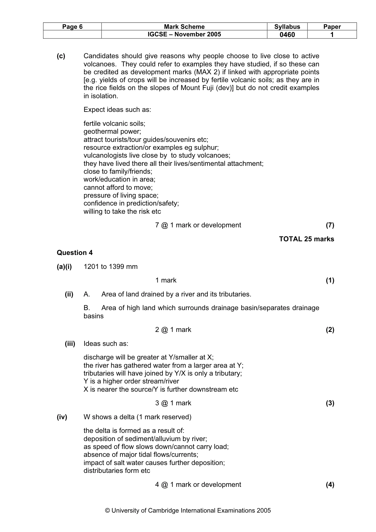
Page 6 Mark Scheme Syllabus Paper IGCSE – November 2005 0460 1 © University of Cambridge International Examinations 2005 (c) Candidates should give reasons why people choose to live close to active volcanoes. They could refer to examples they have studied, if so these can be credited as development marks (MAX 2) if linked with appropriate points [e.g. yields of crops will be increased by fertile volcanic soils; as they are in the rice fields on the slopes of Mount Fuji (dev)] but do not credit examples in isolation. Expect ideas such as: fertile volcanic soils; geothermal power; attract tourists/tour guides/souvenirs etc; resource extraction/or examples eg sulphur; vulcanologists live close by to study volcanoes; they have lived there all their lives/sentimental attachment; close to family/friends; work/education in area; cannot afford to move; pressure of living space; confidence in prediction/safety; willing to take the risk etc 7 @ 1 mark or development (7) TOTAL 25 marks Question 4 (a)(i) 1201 to 1399 mm 1 mark (1) (ii) A. Area of land drained by a river and its tributaries. B. Area of high land which surrounds drainage basin/separates drainage basins 2 @ 1 mark (2) (iii) Ideas such as: discharge will be greater at Y/smaller at X; the river has gathered water from a larger area at Y; tributaries will have joined by Y/X is only a tributary; Y is a higher order stream/river X is nearer the source/Y is further downstream etc 3 @ 1 mark (3) (iv) W shows a delta (1 mark reserved) the delta is formed as a result of: deposition of sediment/alluvium by river; as speed of flow slows down/cannot carry load; absence of major tidal flows/currents; impact of salt water causes further deposition; distributaries form etc 4 @ 1 mark or development (4)
Mark scheme, page 8
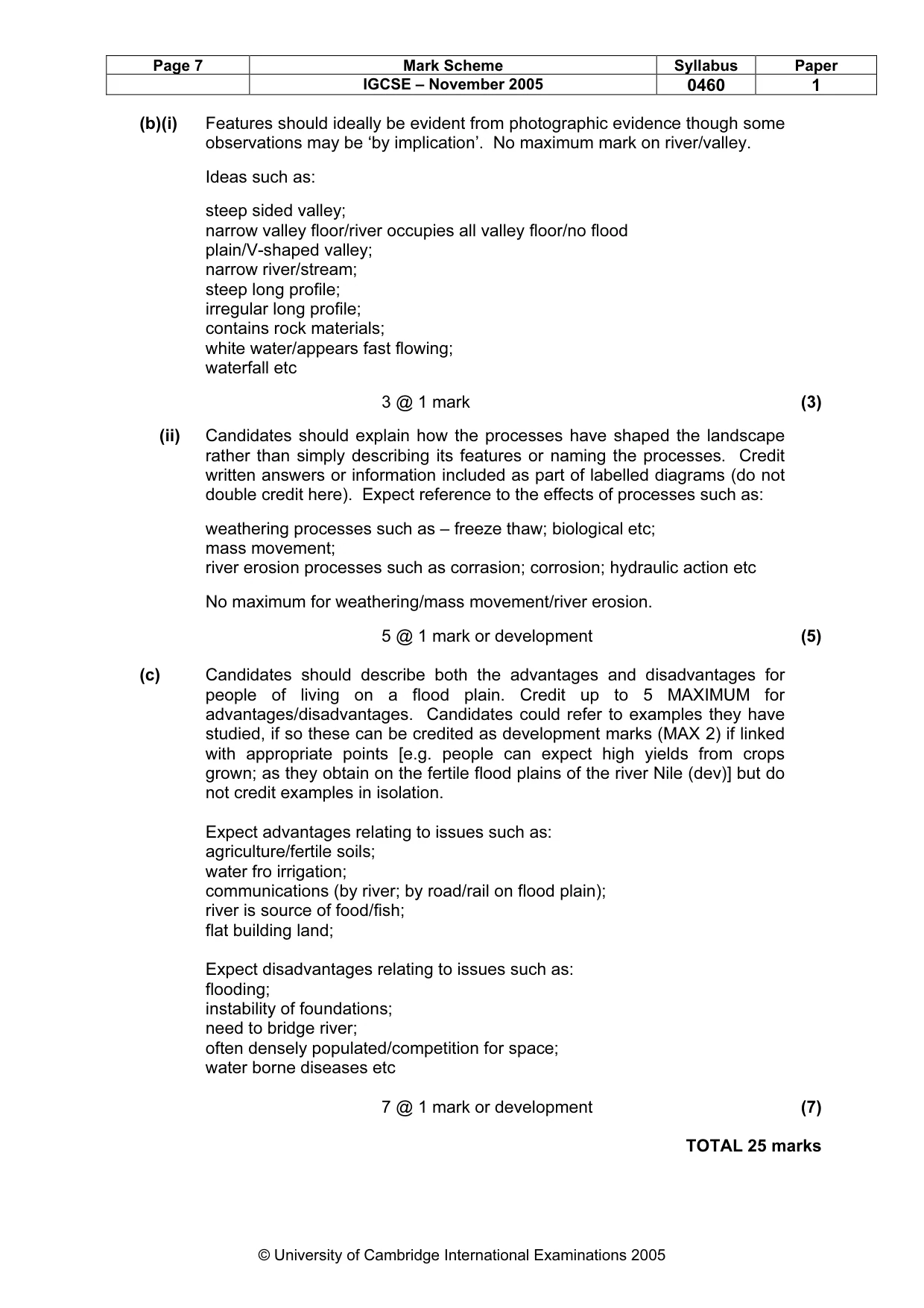
Page 7 Mark Scheme Syllabus Paper IGCSE – November 2005 0460 1 © University of Cambridge International Examinations 2005 (b)(i) Features should ideally be evident from photographic evidence though some observations may be ‘by implication’. No maximum mark on river/valley. Ideas such as: steep sided valley; narrow valley floor/river occupies all valley floor/no flood plain/V-shaped valley; narrow river/stream; steep long profile; irregular long profile; contains rock materials; white water/appears fast flowing; waterfall etc 3 @ 1 mark (3) (ii) Candidates should explain how the processes have shaped the landscape rather than simply describing its features or naming the processes. Credit written answers or information included as part of labelled diagrams (do not double credit here). Expect reference to the effects of processes such as: weathering processes such as – freeze thaw; biological etc; mass movement; river erosion processes such as corrasion; corrosion; hydraulic action etc No maximum for weathering/mass movement/river erosion. 5 @ 1 mark or development (5) (c) Candidates should describe both the advantages and disadvantages for people of living on a flood plain. Credit up to 5 MAXIMUM for advantages/disadvantages. Candidates could refer to examples they have studied, if so these can be credited as development marks (MAX 2) if linked with appropriate points [e.g. people can expect high yields from crops grown; as they obtain on the fertile flood plains of the river Nile (dev)] but do not credit examples in isolation. Expect advantages relating to issues such as: agriculture/fertile soils; water fro irrigation; communications (by river; by road/rail on flood plain); river is source of food/fish; flat building land; Expect disadvantages relating to issues such as: flooding; instability of foundations; need to bridge river; often densely populated/competition for space; water borne diseases etc 7 @ 1 mark or development (7) TOTAL 25 marks
Mark scheme, page 9
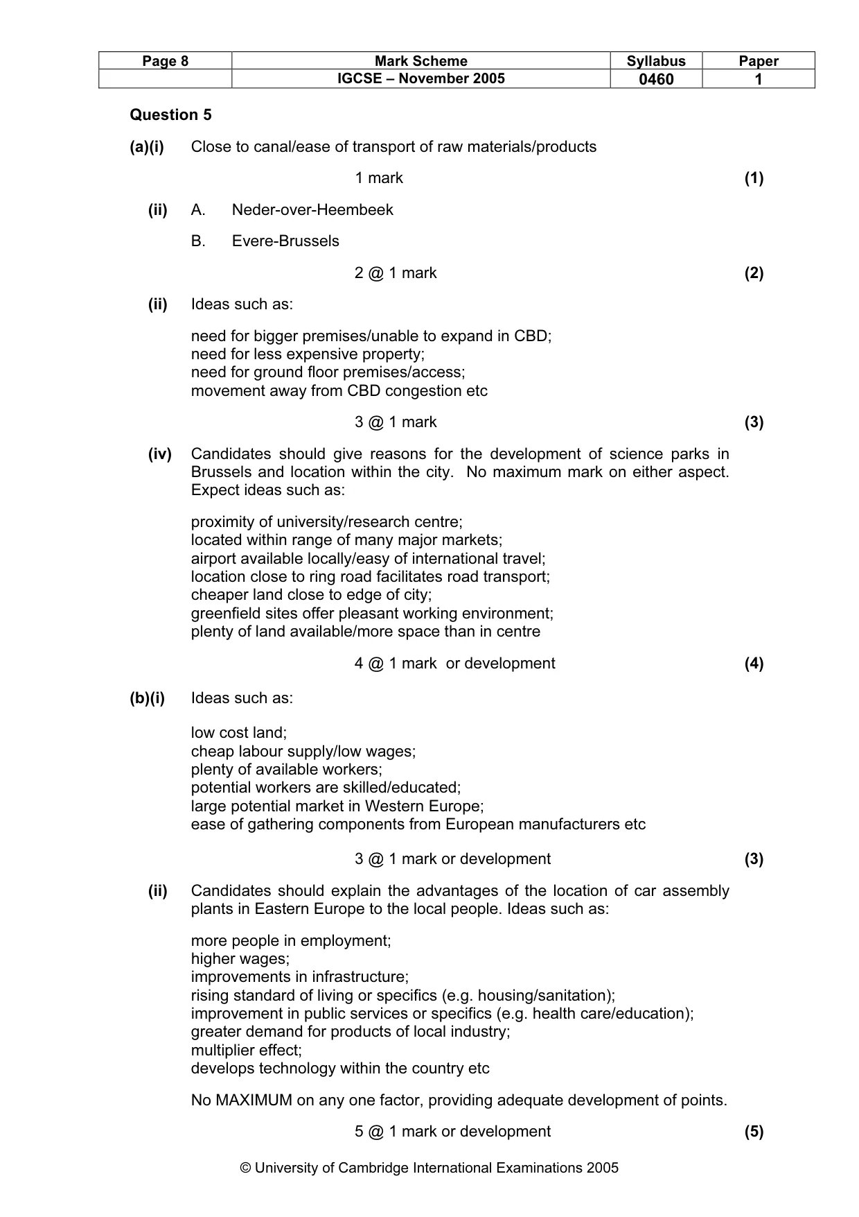
Page 8 Mark Scheme Syllabus Paper IGCSE – November 2005 0460 1 © University of Cambridge International Examinations 2005 Question 5 (a)(i) Close to canal/ease of transport of raw materials/products 1 mark (1) (ii) A. Neder-over-Heembeek B. Evere-Brussels 2 @ 1 mark (2) (ii) Ideas such as: need for bigger premises/unable to expand in CBD; need for less expensive property; need for ground floor premises/access; movement away from CBD congestion etc 3 @ 1 mark (3) (iv) Candidates should give reasons for the development of science parks in Brussels and location within the city. No maximum mark on either aspect. Expect ideas such as: proximity of university/research centre; located within range of many major markets; airport available locally/easy of international travel; location close to ring road facilitates road transport; cheaper land close to edge of city; greenfield sites offer pleasant working environment; plenty of land available/more space than in centre 4 @ 1 mark or development (4) (b)(i) Ideas such as: low cost land; cheap labour supply/low wages; plenty of available workers; potential workers are skilled/educated; large potential market in Western Europe; ease of gathering components from European manufacturers etc 3 @ 1 mark or development (3) (ii) Candidates should explain the advantages of the location of car assembly plants in Eastern Europe to the local people. Ideas such as: more people in employment; higher wages; improvements in infrastructure; rising standard of living or specifics (e.g. housing/sanitation); improvement in public services or specifics (e.g. health care/education); greater demand for products of local industry; multiplier effect; develops technology within the country etc No MAXIMUM on any one factor, providing adequate development of points. 5 @ 1 mark or development (5)
Mark scheme, page 10
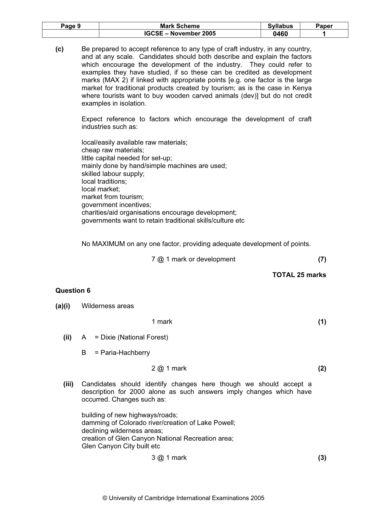
Page 9 Mark Scheme Syllabus Paper IGCSE – November 2005 0460 1 © University of Cambridge International Examinations 2005 (c) Be prepared to accept reference to any type of craft industry, in any country, and at any scale. Candidates should both describe and explain the factors which encourage the development of the industry. They could refer to examples they have studied, if so these can be credited as development marks (MAX 2) if linked with appropriate points [e.g. one factor is the large market for traditional products created by tourism; as is the case in Kenya where tourists want to buy wooden carved animals (dev)] but do not credit examples in isolation. Expect reference to factors which encourage the development of craft industries such as: local/easily available raw materials; cheap raw materials; little capital needed for set-up; mainly done by hand/simple machines are used; skilled labour supply; local traditions; local market; market from tourism; government incentives; charities/aid organisations encourage development; governments want to retain traditional skills/culture etc No MAXIMUM on any one factor, providing adequate development of points. 7 @ 1 mark or development (7) TOTAL 25 marks Question 6 (a)(i) Wilderness areas 1 mark (1) (ii) A = Dixie (National Forest) B = Paria-Hachberry 2 @ 1 mark (2) (iii) Candidates should identify changes here though we should accept a description for 2000 alone as such answers imply changes which have occurred. Changes such as: building of new highways/roads; damming of Colorado river/creation of Lake Powell; declining wilderness areas; creation of Glen Canyon National Recreation area; Glen Canyon City built etc 3 @ 1 mark (3)
Mark scheme, page 11
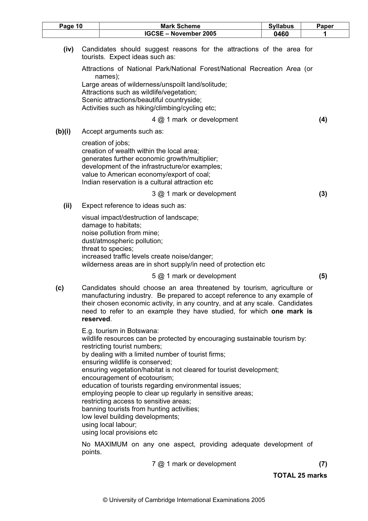
Page 10 Mark Scheme Syllabus Paper IGCSE – November 2005 0460 1 © University of Cambridge International Examinations 2005 (iv) Candidates should suggest reasons for the attractions of the area for tourists. Expect ideas such as: Attractions of National Park/National Forest/National Recreation Area (or names); Large areas of wilderness/unspoilt land/solitude; Attractions such as wildlife/vegetation; Scenic attractions/beautiful countryside; Activities such as hiking/climbing/cycling etc; 4 @ 1 mark or development (4) (b)(i) Accept arguments such as: creation of jobs; creation of wealth within the local area; generates further economic growth/multiplier; development of the infrastructure/or examples; value to American economy/export of coal; Indian reservation is a cultural attraction etc 3 @ 1 mark or development (3) (ii) Expect reference to ideas such as: visual impact/destruction of landscape; damage to habitats; noise pollution from mine; dust/atmospheric pollution; threat to species; increased traffic levels create noise/danger; wilderness areas are in short supply/in need of protection etc 5 @ 1 mark or development (5) (c) Candidates should choose an area threatened by tourism, agriculture or manufacturing industry. Be prepared to accept reference to any example of their chosen economic activity, in any country, and at any scale. Candidates need to refer to an example they have studied, for which one mark is reserved. E.g. tourism in Botswana: wildlife resources can be protected by encouraging sustainable tourism by: restricting tourist numbers; by dealing with a limited number of tourist firms; ensuring wildlife is conserved; ensuring vegetation/habitat is not cleared for tourist development; encouragement of ecotourism; education of tourists regarding environmental issues; employing people to clear up regularly in sensitive areas; restricting access to sensitive areas; banning tourists from hunting activities; low level building developments; using local labour; using local provisions etc No MAXIMUM on any one aspect, providing adequate development of points. 7 @ 1 mark or development (7) TOTAL 25 marks