Cambridge A Level Environmental Management (AS only) 8291 — 2017 May/June Paper 1 · Variant 1
8291/11/M/J/17 · 80 marks · ≈90 min
The question paper and its mark scheme, free to read here and free to download. This is Cambridge’s own paper, exactly as it was sat.
Question paper12 pages


Mark scheme18 pages
Answers below. Sit the paper first if you are practising.
Paper as text
Question paper, page 1
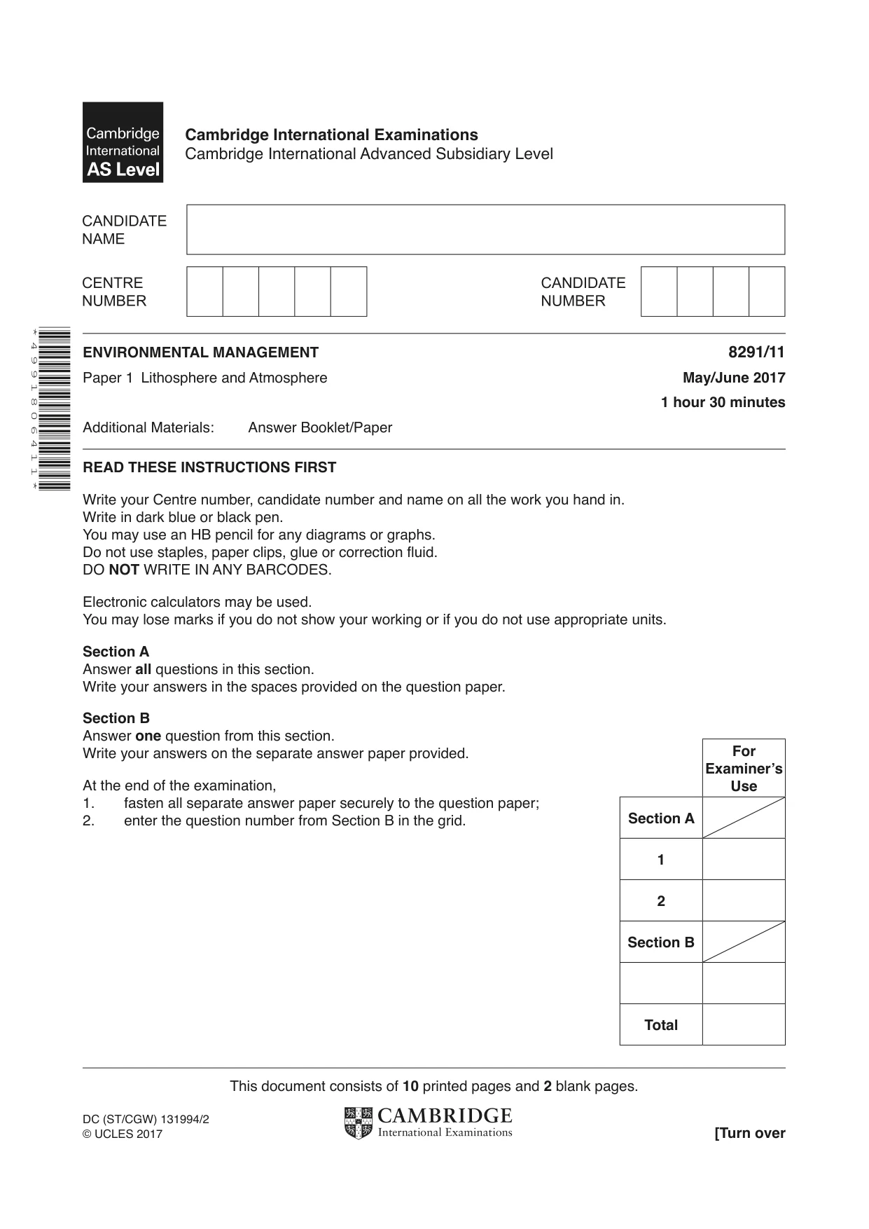
This document consists of 10 printed pages and 2 blank pages. DC (ST/CGW) 131994/2 © UCLES 2017 [Turn over Cambridge International Examinations Cambridge International Advanced Subsidiary Level * 4 9 9 1 8 0 6 4 1 1 * ENVIRONMENTAL MANAGEMENT 8291/11 Paper 1 Lithosphere and Atmosphere May/June 2017 1 hour 30 minutes Additional Materials: Answer Booklet/Paper READ THESE INSTRUCTIONS FIRST Write your Centre number, candidate number and name on all the work you hand in. Write in dark blue or black pen. You may use an HB pencil for any diagrams or graphs. Do not use staples, paper clips, glue or correction fluid. DO NOT WRITE IN ANY BARCODES. Electronic calculators may be used. You may lose marks if you do not show your working or if you do not use appropriate units. Section A Answer all questions in this section. Write your answers in the spaces provided on the question paper. Section B Answer one question from this section. Write your answers on the separate answer paper provided. At the end of the examination, 1. fasten all separate answer paper securely to the question paper; 2. enter the question number from Section B in the grid. For Examiner’s Use Section A 1 2 Section B Total
Question paper, page 2
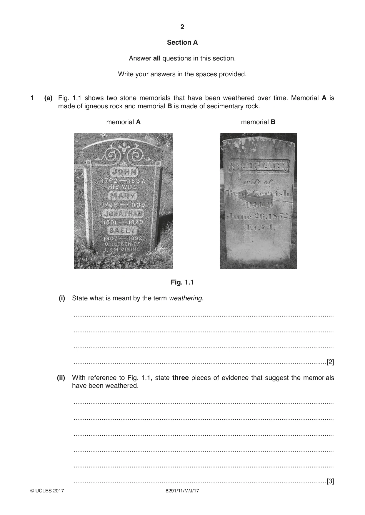
2 8291/11/M/J/17 © UCLES 2017 Section A Answer all questions in this section. Write your answers in the spaces provided. 1 (a) Fig. 1.1 shows two stone memorials that have been weathered over time. Memorial A is made of igneous rock and memorial B is made of sedimentary rock. memorial A memorial B Fig. 1.1 (i) State what is meant by the term weathering. … … … …[2] (ii) With reference to Fig. 1.1, state three pieces of evidence that suggest the memorials have been weathered. … … … … … …[3]
Question paper, page 3
3 8291/11/M/J/17 © UCLES 2017 [Turn over (iii) With reference to Fig. 1.1, explain how rock type may affect the rate of weathering. … … … … … …[3] (iv) Explain two factors, other than rock type, that may cause differences in the rate of weathering of stone memorials. … … … … … … … …[4]
Question paper, page 4
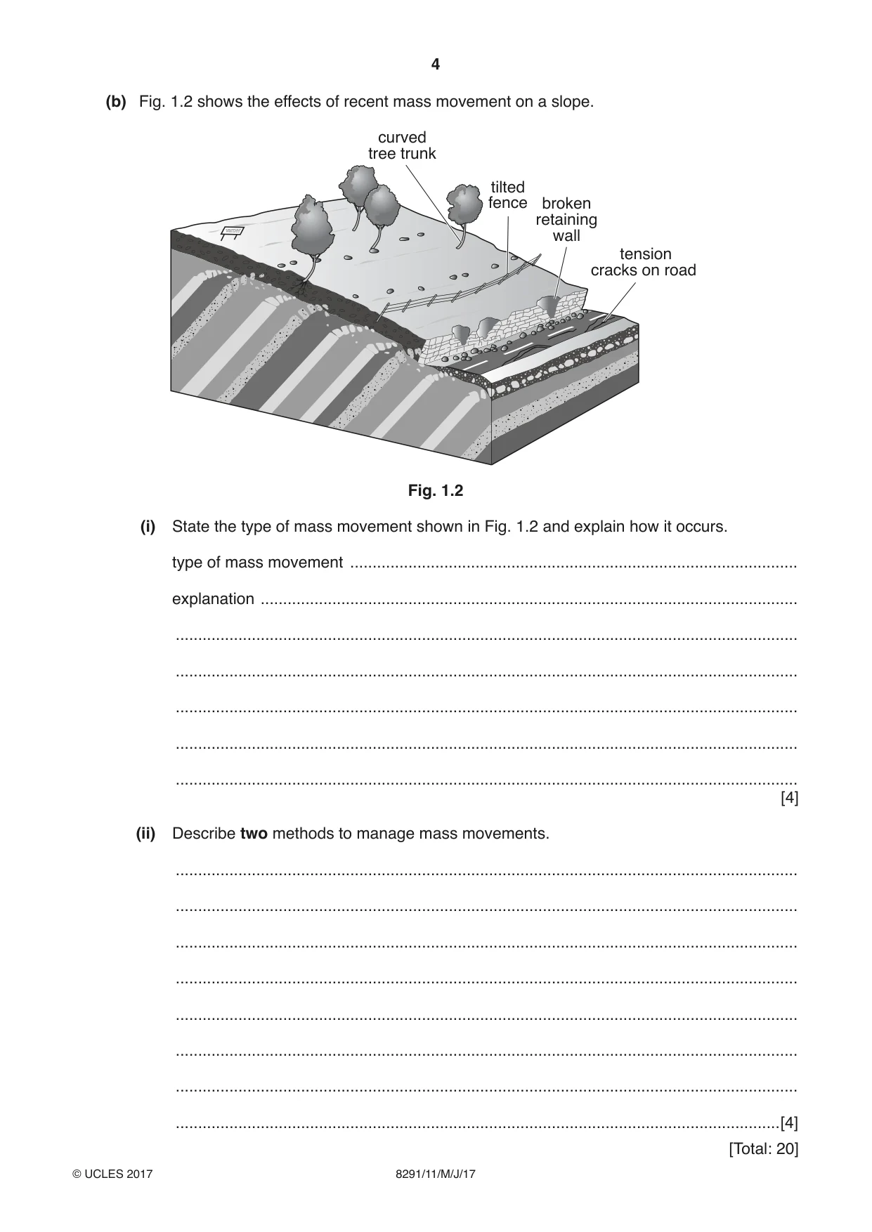
4 8291/11/M/J/17 © UCLES 2017 (b) Fig. 1.2 shows the effects of recent mass movement on a slope. curved tree trunk tilted fence tension cracks on road broken retaining wall Fig. 1.2 (i) State the type of mass movement shown in Fig. 1.2 and explain how it occurs. type of mass movement … explanation … … … … … … [4] (ii) Describe two methods to manage mass movements. … … … … … … … …[4] [Total: 20]
Question paper, page 5
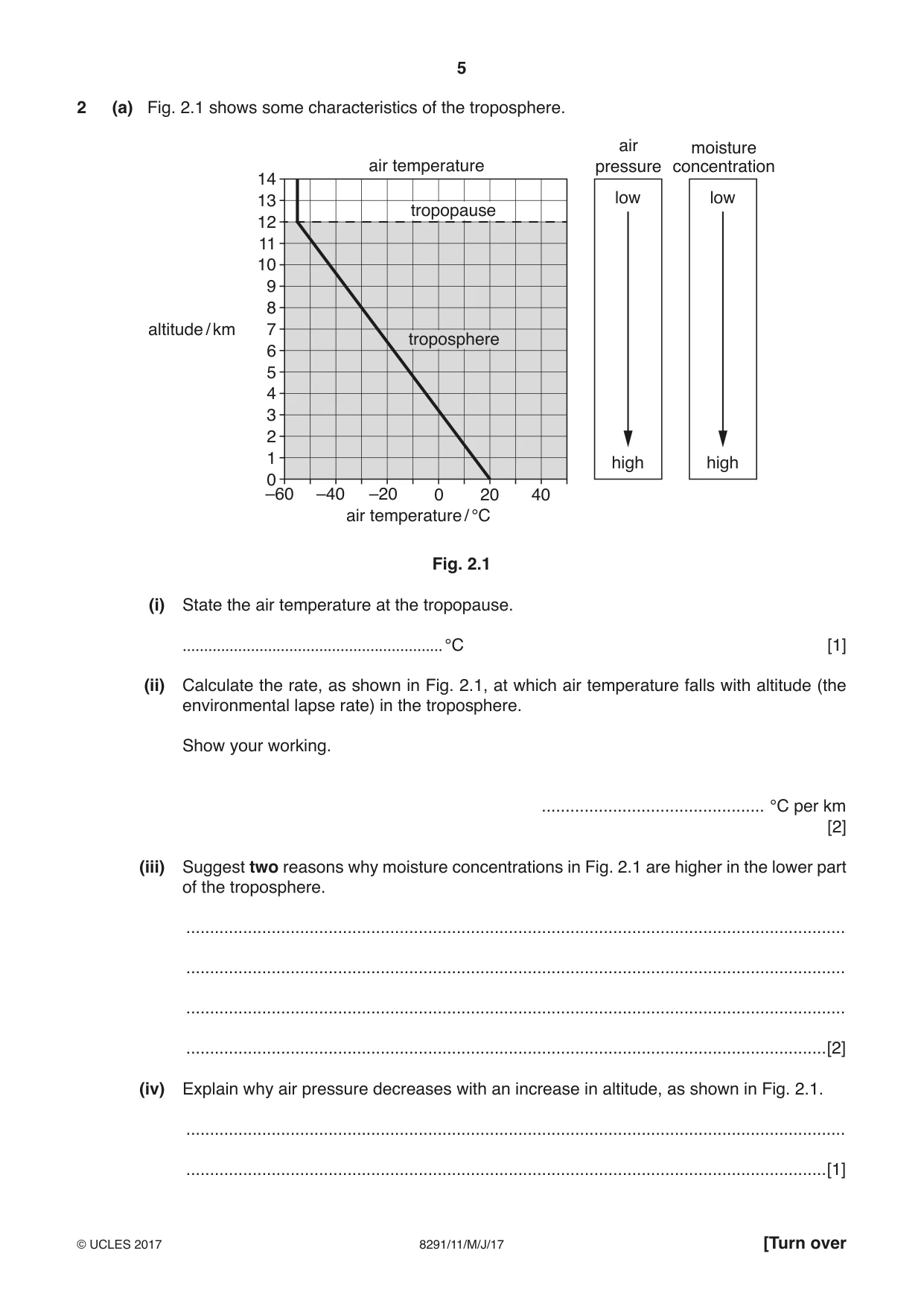
5 8291/11/M/J/17 © UCLES 2017 [Turn over 2 (a) Fig. 2.1 shows some characteristics of the troposphere. 14 13 12 11 10 9 8 7 altitude / km air temperature low moisture concentration air pressure low high high 6 5 4 3 2 1 –60 –40 –20 air temperature / °C 20 40 0 0 tropopause troposphere Fig. 2.1 (i) State the air temperature at the tropopause. … °C [1] (ii) Calculate the rate, as shown in Fig. 2.1, at which air temperature falls with altitude (the environmental lapse rate) in the troposphere. Show your working. … °C per km [2] (iii) Suggest two reasons why moisture concentrations in Fig. 2.1 are higher in the lower part of the troposphere. … … … …[2] (iv) Explain why air pressure decreases with an increase in altitude, as shown in Fig. 2.1. … …[1]
Question paper, page 6
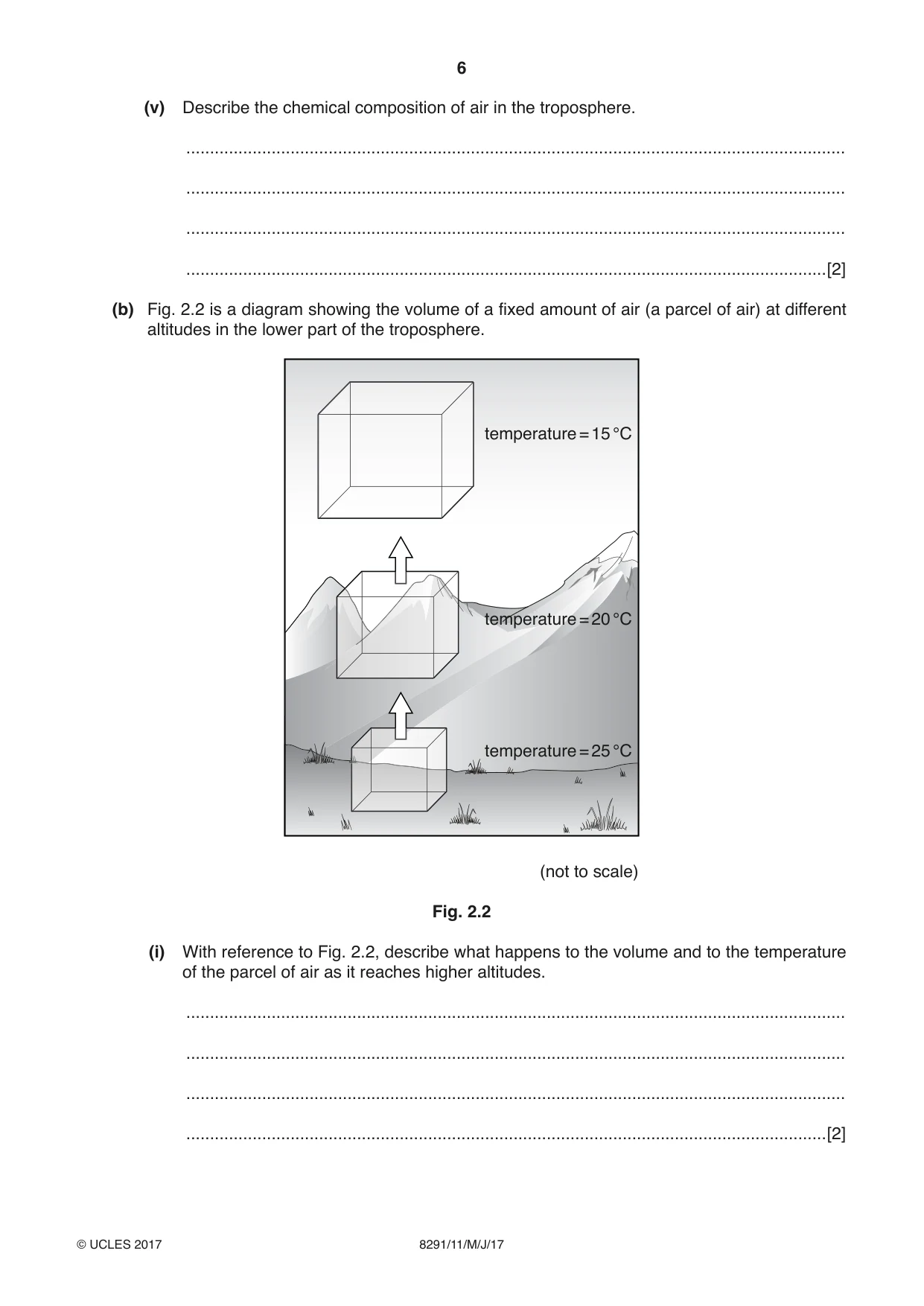
6 8291/11/M/J/17 © UCLES 2017 (v) Describe the chemical composition of air in the troposphere. … … … …[2] (b) Fig. 2.2 is a diagram showing the volume of a fixed amount of air (a parcel of air) at different altitudes in the lower part of the troposphere. temperature = 15 °C temperature = 20 °C temperature = 25 °C (not to scale) Fig. 2.2 (i) With reference to Fig. 2.2, describe what happens to the volume and to the temperature of the parcel of air as it reaches higher altitudes. … … … …[2]
Question paper, page 7
7 8291/11/M/J/17 © UCLES 2017 [Turn over (ii) Suggest two reasons why a parcel of air might be forced to rise as shown in Fig. 2.2. … … … … … … … …[4] (c) Explain why weather can be hazardous for people. … … … … … … … … … … … …[6] [Total: 20]
Question paper, page 8
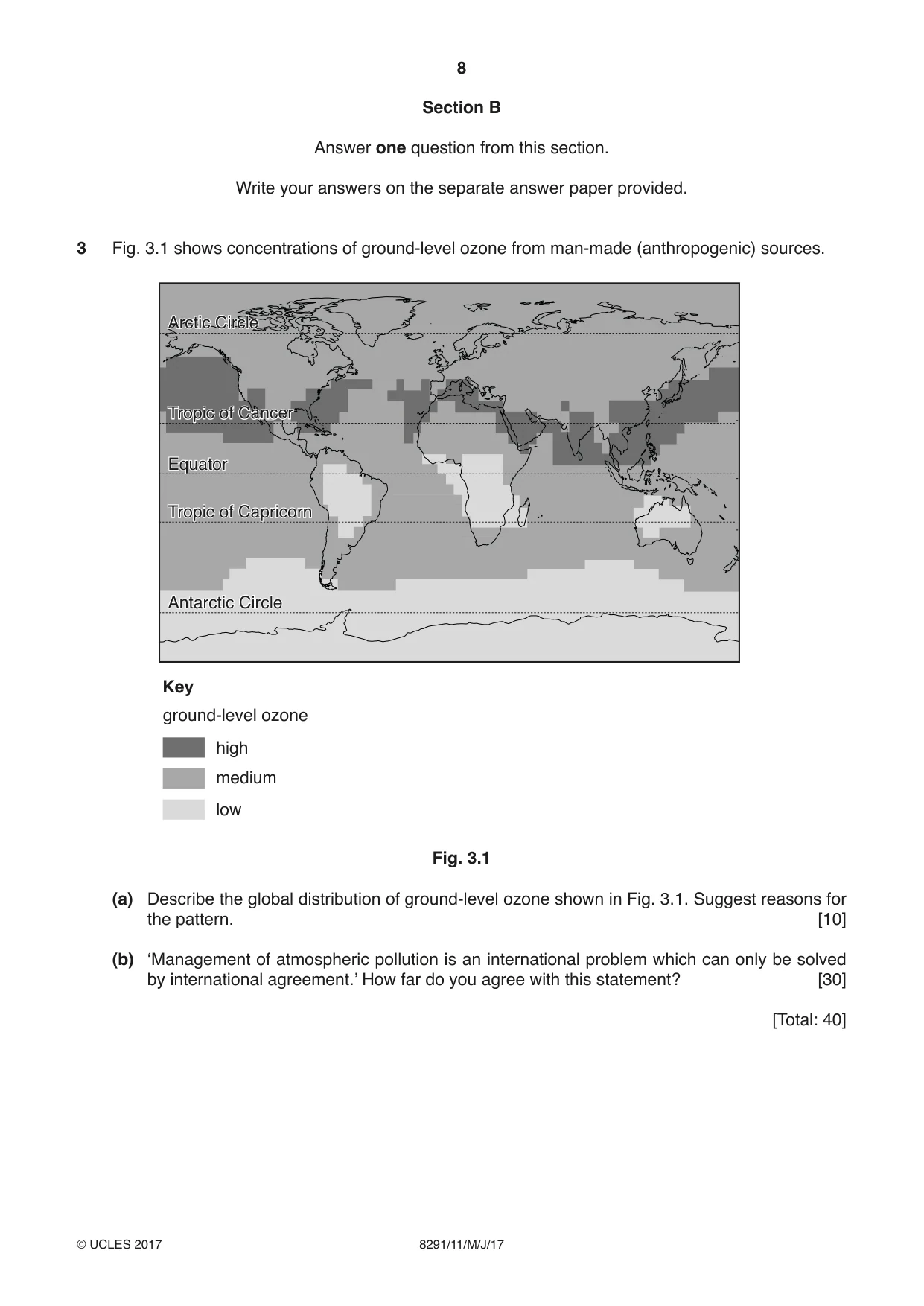
8 8291/11/M/J/17 © UCLES 2017 Section B Answer one question from this section. Write your answers on the separate answer paper provided. 3 Fig. 3.1 shows concentrations of ground-level ozone from man-made (anthropogenic) sources. high Key ground-level ozone medium low Antarctic Circle Tropic of Capricorn Equator Tropic of Cancer Arctic Circle Antarctic Circle Tropic of Capricorn Equator Tropic of Cancer Arctic Circle Fig. 3.1 (a) Describe the global distribution of ground-level ozone shown in Fig. 3.1. Suggest reasons for the pattern. [10] (b) ‘Management of atmospheric pollution is an international problem which can only be solved by international agreement.’ How far do you agree with this statement? [30] [Total: 40]
Question paper, page 9
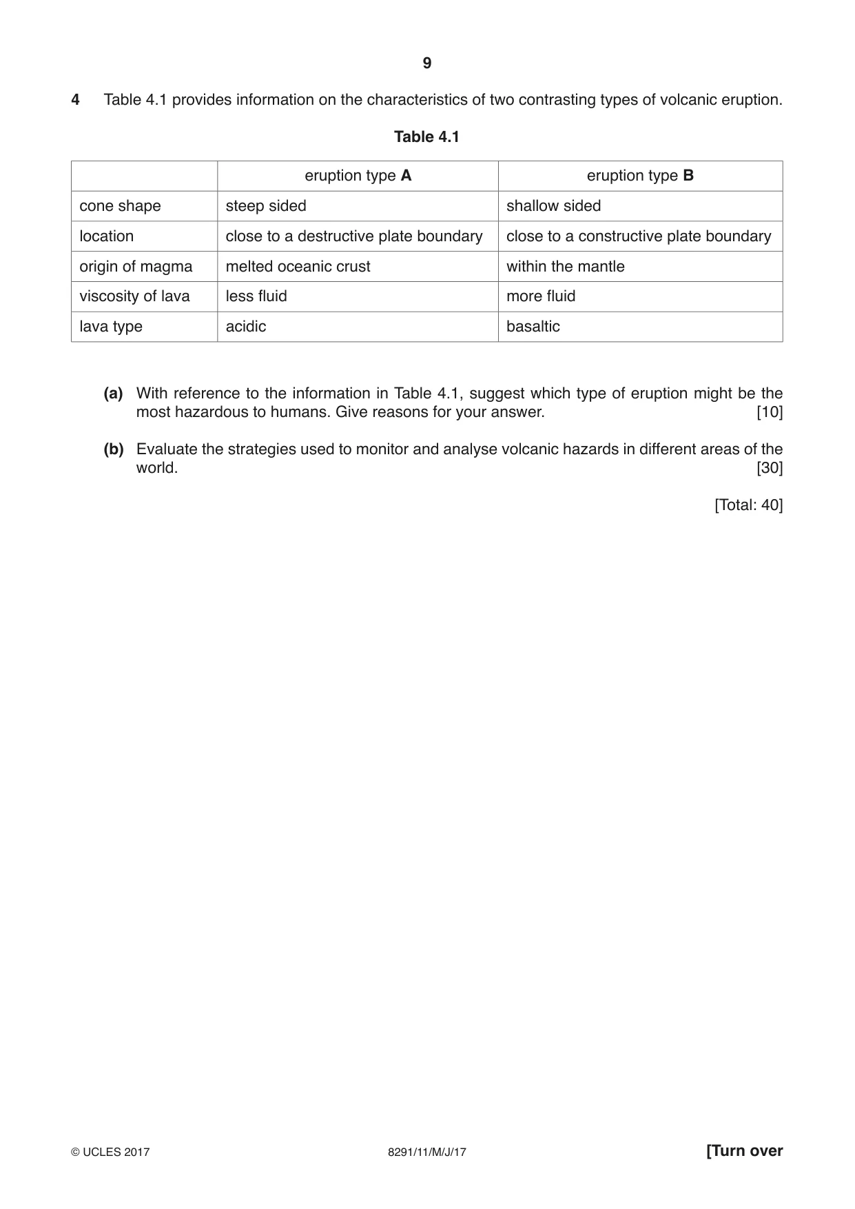
9 8291/11/M/J/17 © UCLES 2017 [Turn over 4 Table 4.1 provides information on the characteristics of two contrasting types of volcanic eruption. Table 4.1 eruption type A eruption type B cone shape steep sided shallow sided location close to a destructive plate boundary close to a constructive plate boundary origin of magma melted oceanic crust within the mantle viscosity of lava less fluid more fluid lava type acidic basaltic (a) With reference to the information in Table 4.1, suggest which type of eruption might be the most hazardous to humans. Give reasons for your answer. [10] (b) Evaluate the strategies used to monitor and analyse volcanic hazards in different areas of the world. [30] [Total: 40]
Question paper, page 10
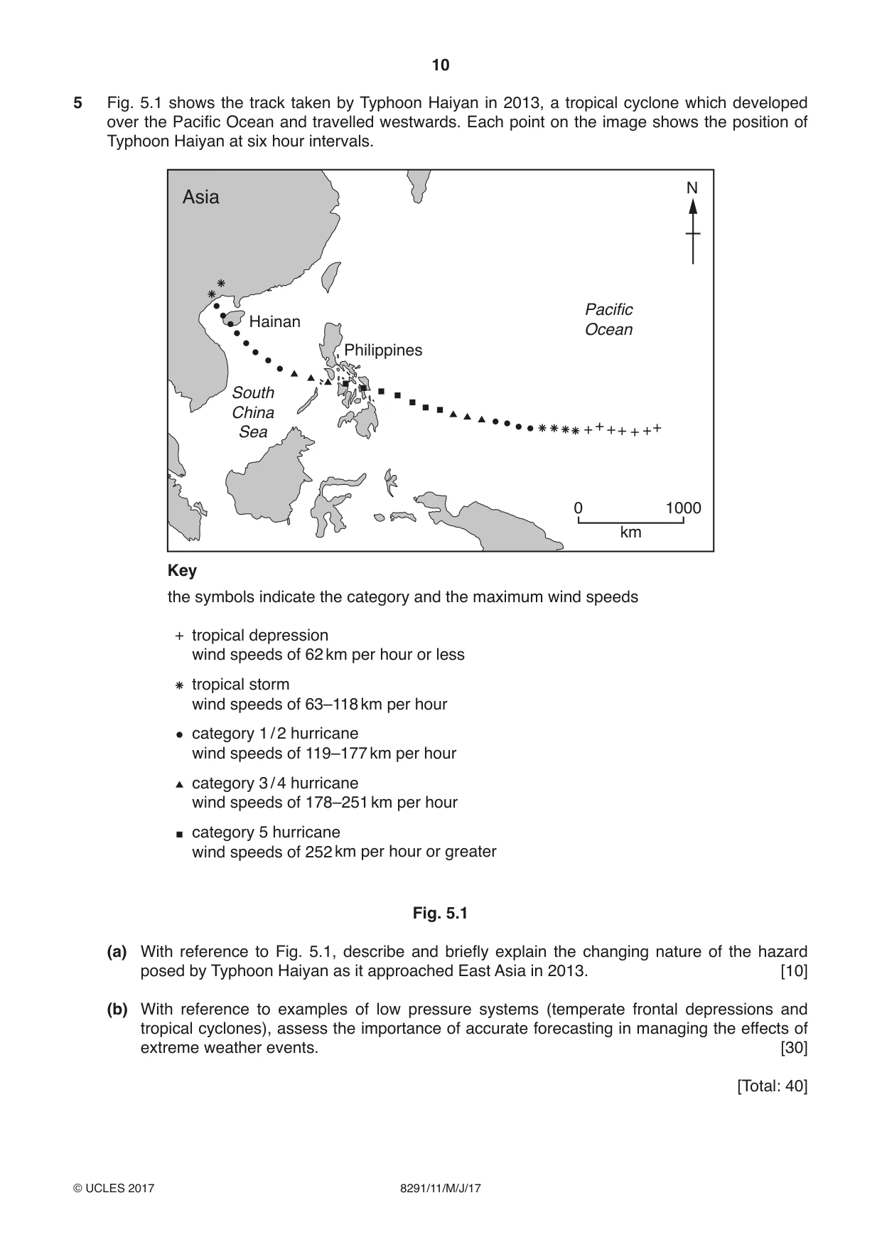
10 8291/11/M/J/17 © UCLES 2017 5 Fig. 5.1 shows the track taken by Typhoon Haiyan in 2013, a tropical cyclone which developed over the Pacific Ocean and travelled westwards. Each point on the image shows the position of Typhoon Haiyan at six hour intervals. Key tropical depression wind speeds of 62 km per hour or less the symbols indicate the category and the maximum wind speeds Asia Philippines Pacific Ocean South China Sea Hainan tropical storm wind speeds of 63–118 km per hour category 1 / 2 hurricane wind speeds of 119–177 km per hour category 3 / 4 hurricane wind speeds of 178–251 km per hour category 5 hurricane wind speeds of 252 km per hour or greater N km 0 1000 Fig. 5.1 (a) With reference to Fig. 5.1, describe and briefly explain the changing nature of the hazard posed by Typhoon Haiyan as it approached East Asia in 2013. [10] (b) With reference to examples of low pressure systems (temperate frontal depressions and tropical cyclones), assess the importance of accurate forecasting in managing the effects of extreme weather events. [30] [Total: 40]
Question paper, page 11
11 8291/11/M/J/17 © UCLES 2017 BLANK PAGE
Question paper, page 12
12 8291/11/M/J/17 © UCLES 2017 Permission to reproduce items where third-party owned material protected by copyright is included has been sought and cleared where possible. Every reasonable effort has been made by the publisher (UCLES) to trace copyright holders, but if any items requiring clearance have unwittingly been included, the publisher will be pleased to make amends at the earliest possible opportunity. To avoid the issue of disclosure of answer-related information to candidates, all copyright acknowledgements are reproduced online in the Cambridge International Examinations Copyright Acknowledgements Booklet. This is produced for each series of examinations and is freely available to download at www.cie.org.uk after the live examination series. Cambridge International Examinations is part of the Cambridge Assessment Group. Cambridge Assessment is the brand name of University of Cambridge Local Examinations Syndicate (UCLES), which is itself a department of the University of Cambridge. BLANK PAGE
Mark scheme, page 1
® IGCSE is a registered trademark. This document consists of 18 printed pages. © UCLES 2017 [Turn over Cambridge International Examinations Cambridge International Advanced Subsidiary Level ENVIRONMENTAL MANAGEMENT 8291/11 Paper 1 May/June 2017 MARK SCHEME Maximum Mark: 80 Published This mark scheme is published as an aid to teachers and candidates, to indicate the requirements of the examination. It shows the basis on which Examiners were instructed to award marks. It does not indicate the details of the discussions that took place at an Examiners’ meeting before marking began, which would have considered the acceptability of alternative answers. Mark schemes should be read in conjunction with the question paper and the Principal Examiner Report for Teachers. Cambridge will not enter into discussions about these mark schemes. Cambridge is publishing the mark schemes for the May/June 2017 series for most Cambridge IGCSE®, Cambridge International A and AS Level and Cambridge Pre-U components, and some Cambridge O Level components.
Mark scheme, page 2
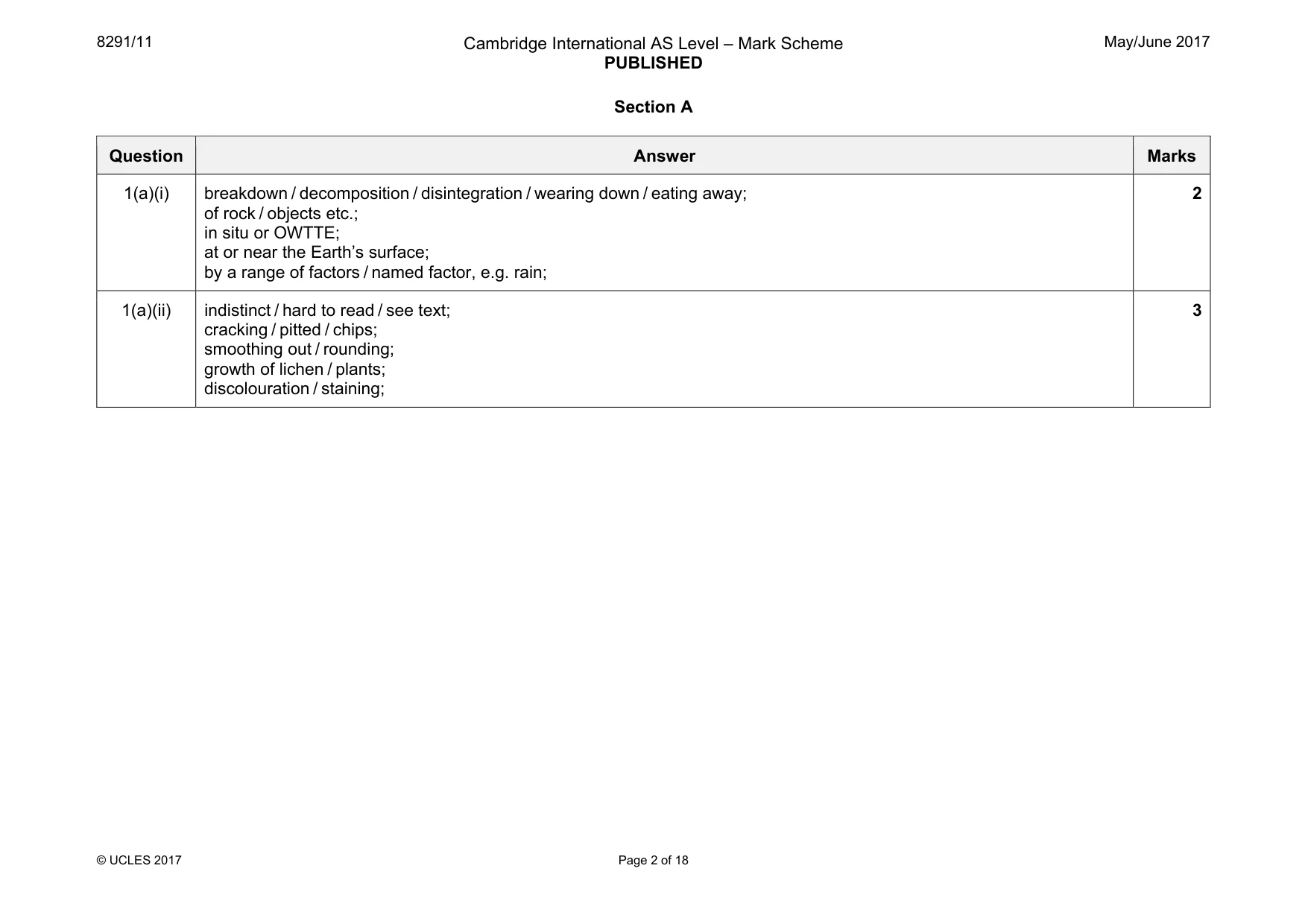
8291/11 Cambridge International AS Level – Mark Scheme PUBLISHED May/June 2017 © UCLES 2017 Page 2 of 18 Section A Question Answer Marks 1(a)(i) breakdown / decomposition / disintegration / wearing down / eating away; of rock / objects etc.; in situ or OWTTE; at or near the Earth’s surface; by a range of factors / named factor, e.g. rain; 2 1(a)(ii) indistinct / hard to read / see text; cracking / pitted / chips; smoothing out / rounding; growth of lichen / plants; discolouration / staining; 3
Mark scheme, page 3
8291/11 Cambridge International AS Level – Mark Scheme PUBLISHED May/June 2017 © UCLES 2017 Page 3 of 18 Question Answer Marks 1(a)(iii) One mark for a factor. Allow additional marks for a developed point for a factor. Max. two marks for a list of factors without explanation. One mark max. for ref. to valid rate comparison / magnitude. Candidates may use rock type in the context of igneous vs. sedimentary or may relate to particular rocks, or describe general properties. hardness; makes it more resistant to mechanical damage; mineral composition, e.g. acidity / solubility; affects the response to water / acidic precipitation / growth of plants, e.g. lichens; structure of rock, e.g. density of joints; affects resistance to mechanical damage; porosity / permeability; the more access given to water the greater the weathering; sedimentary weaker / OWTTE than other types; made up of grains; ORA igneous formed through heat; harder; 3
Mark scheme, page 4
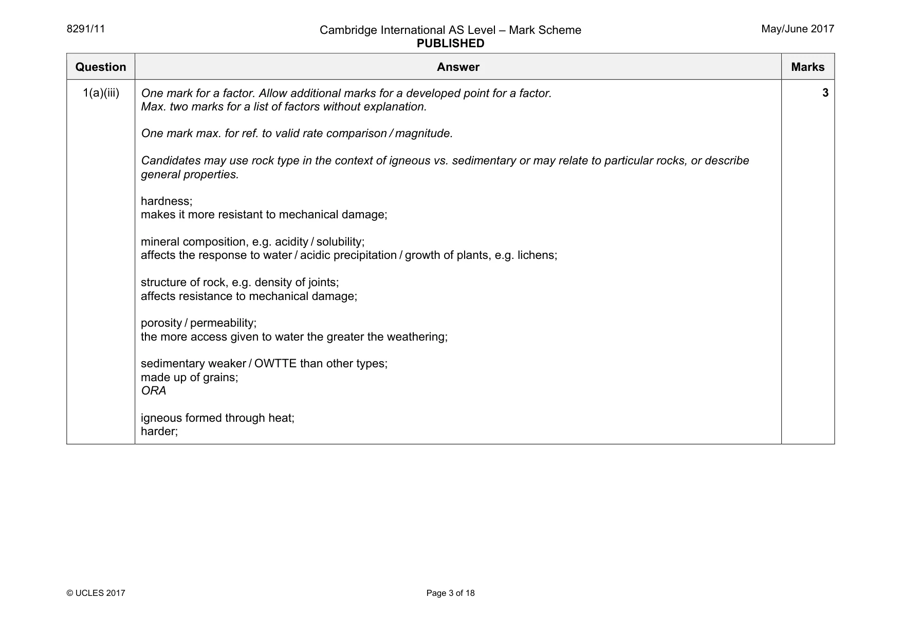
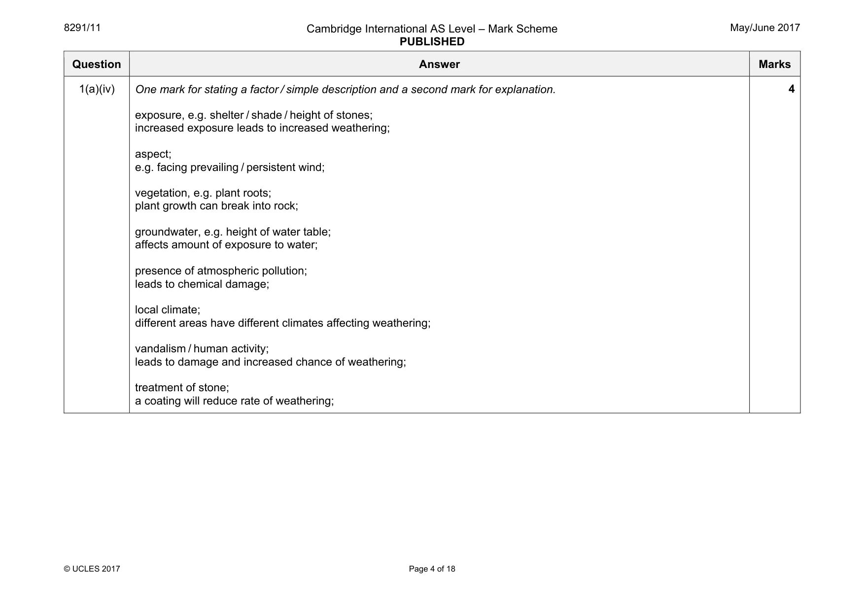
8291/11 Cambridge International AS Level – Mark Scheme PUBLISHED May/June 2017 © UCLES 2017 Page 4 of 18 Question Answer Marks 1(a)(iv) One mark for stating a factor / simple description and a second mark for explanation. exposure, e.g. shelter / shade / height of stones; increased exposure leads to increased weathering; aspect; e.g. facing prevailing / persistent wind; vegetation, e.g. plant roots; plant growth can break into rock; groundwater, e.g. height of water table; affects amount of exposure to water; presence of atmospheric pollution; leads to chemical damage; local climate; different areas have different climates affecting weathering; vandalism / human activity; leads to damage and increased chance of weathering; treatment of stone; a coating will reduce rate of weathering; 4
Mark scheme, page 5
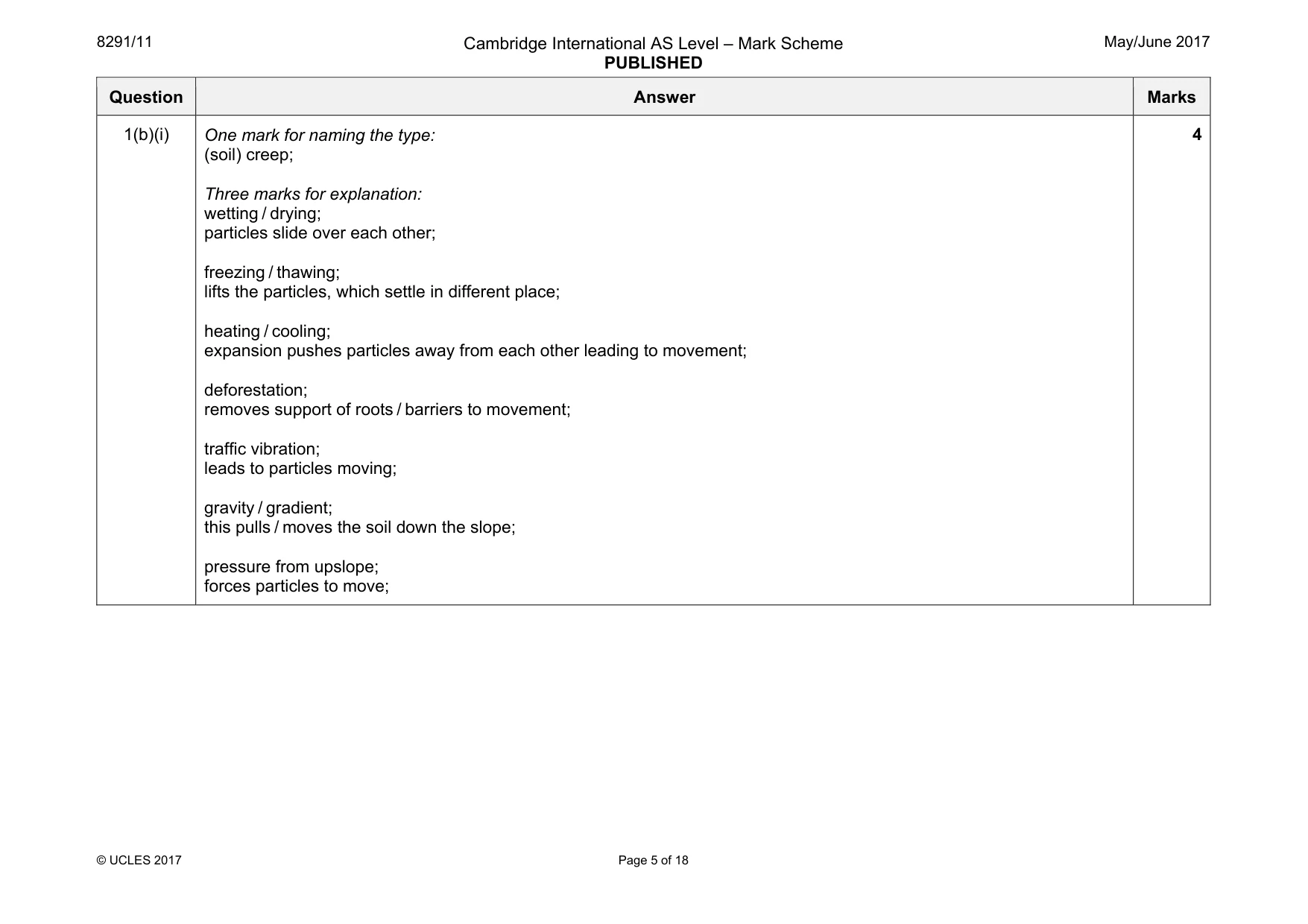
8291/11 Cambridge International AS Level – Mark Scheme PUBLISHED May/June 2017 © UCLES 2017 Page 5 of 18 Question Answer Marks 1(b)(i) One mark for naming the type: (soil) creep; Three marks for explanation: wetting / drying; particles slide over each other; freezing / thawing; lifts the particles, which settle in different place; heating / cooling; expansion pushes particles away from each other leading to movement; deforestation; removes support of roots / barriers to movement; traffic vibration; leads to particles moving; gravity / gradient; this pulls / moves the soil down the slope; pressure from upslope; forces particles to move; 4
Mark scheme, page 6
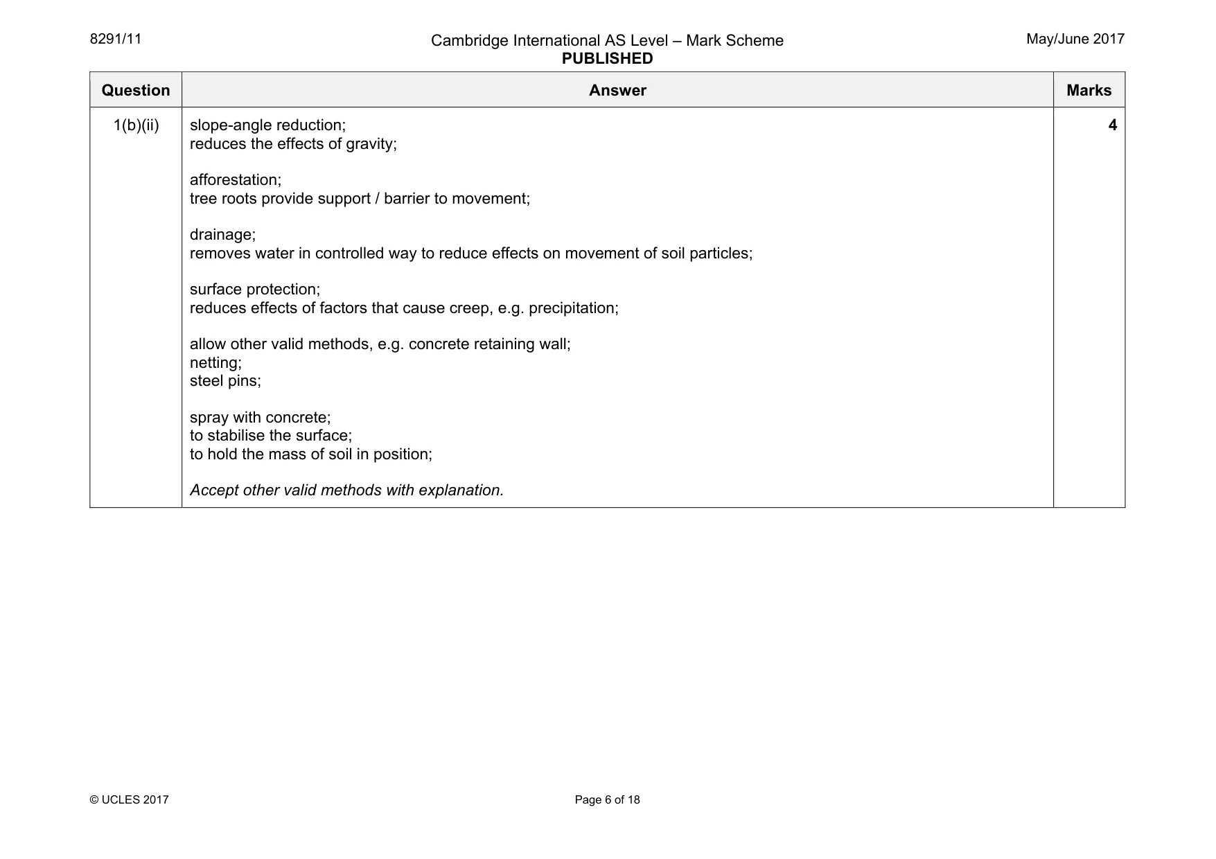
8291/11 Cambridge International AS Level – Mark Scheme PUBLISHED May/June 2017 © UCLES 2017 Page 6 of 18 Question Answer Marks 1(b)(ii) slope-angle reduction; reduces the effects of gravity; afforestation; tree roots provide support / barrier to movement; drainage; removes water in controlled way to reduce effects on movement of soil particles; surface protection; reduces effects of factors that cause creep, e.g. precipitation; allow other valid methods, e.g. concrete retaining wall; netting; steel pins; spray with concrete; to stabilise the surface; to hold the mass of soil in position; Accept other valid methods with explanation. 4
Mark scheme, page 7
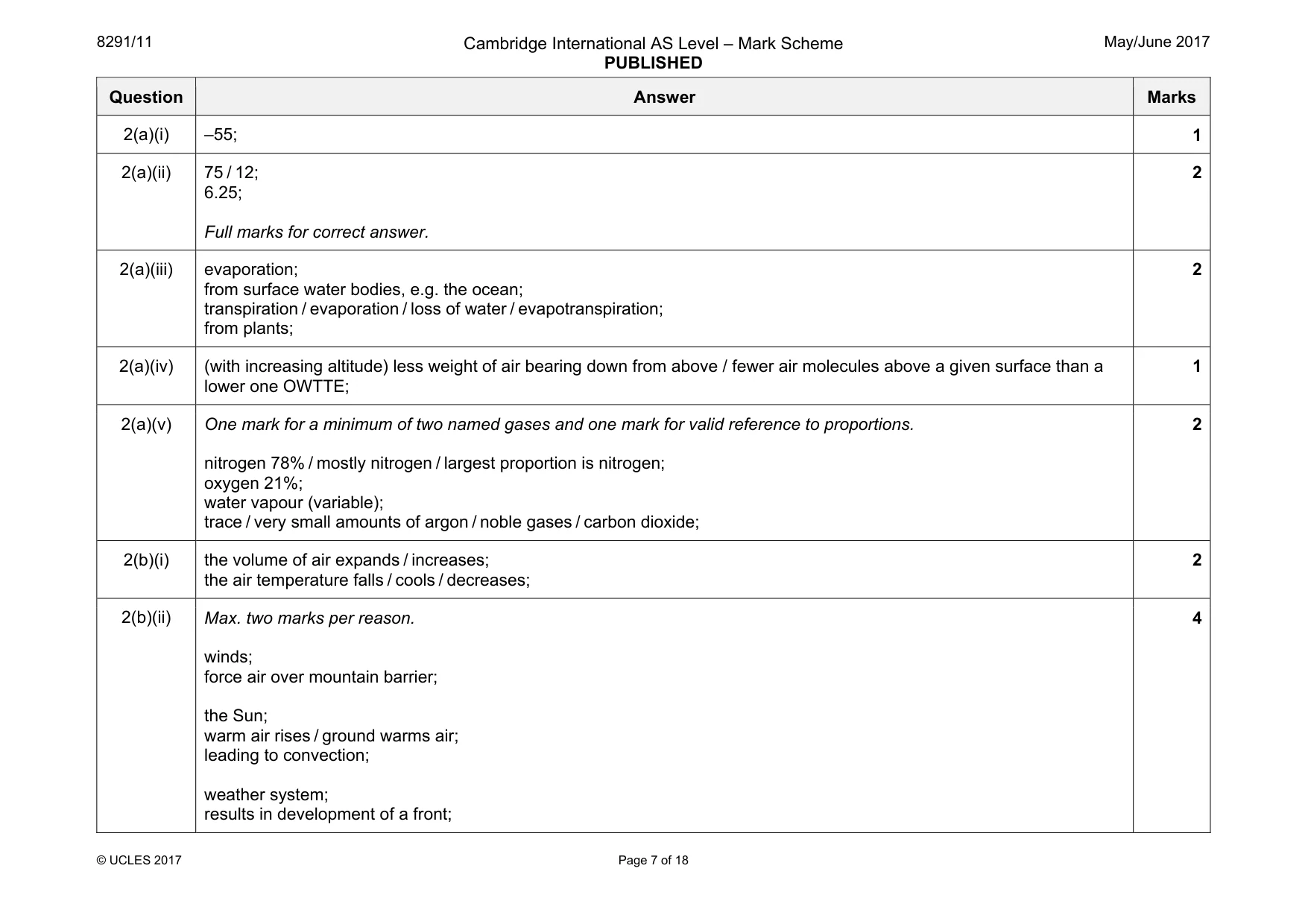
8291/11 Cambridge International AS Level – Mark Scheme PUBLISHED May/June 2017 © UCLES 2017 Page 7 of 18 Question Answer Marks 2(a)(i) –55; 1 2(a)(ii) 75 / 12; 6.25; Full marks for correct answer. 2 2(a)(iii) evaporation; from surface water bodies, e.g. the ocean; transpiration / evaporation / loss of water / evapotranspiration; from plants; 2 2(a)(iv) (with increasing altitude) less weight of air bearing down from above / fewer air molecules above a given surface than a lower one OWTTE; 1 2(a)(v) One mark for a minimum of two named gases and one mark for valid reference to proportions. nitrogen 78% / mostly nitrogen / largest proportion is nitrogen; oxygen 21%; water vapour (variable); trace / very small amounts of argon / noble gases / carbon dioxide; 2 2(b)(i) the volume of air expands / increases; the air temperature falls / cools / decreases; 2 2(b)(ii) Max. two marks per reason. winds; force air over mountain barrier; the Sun; warm air rises / ground warms air; leading to convection; weather system; results in development of a front; 4
Mark scheme, page 8
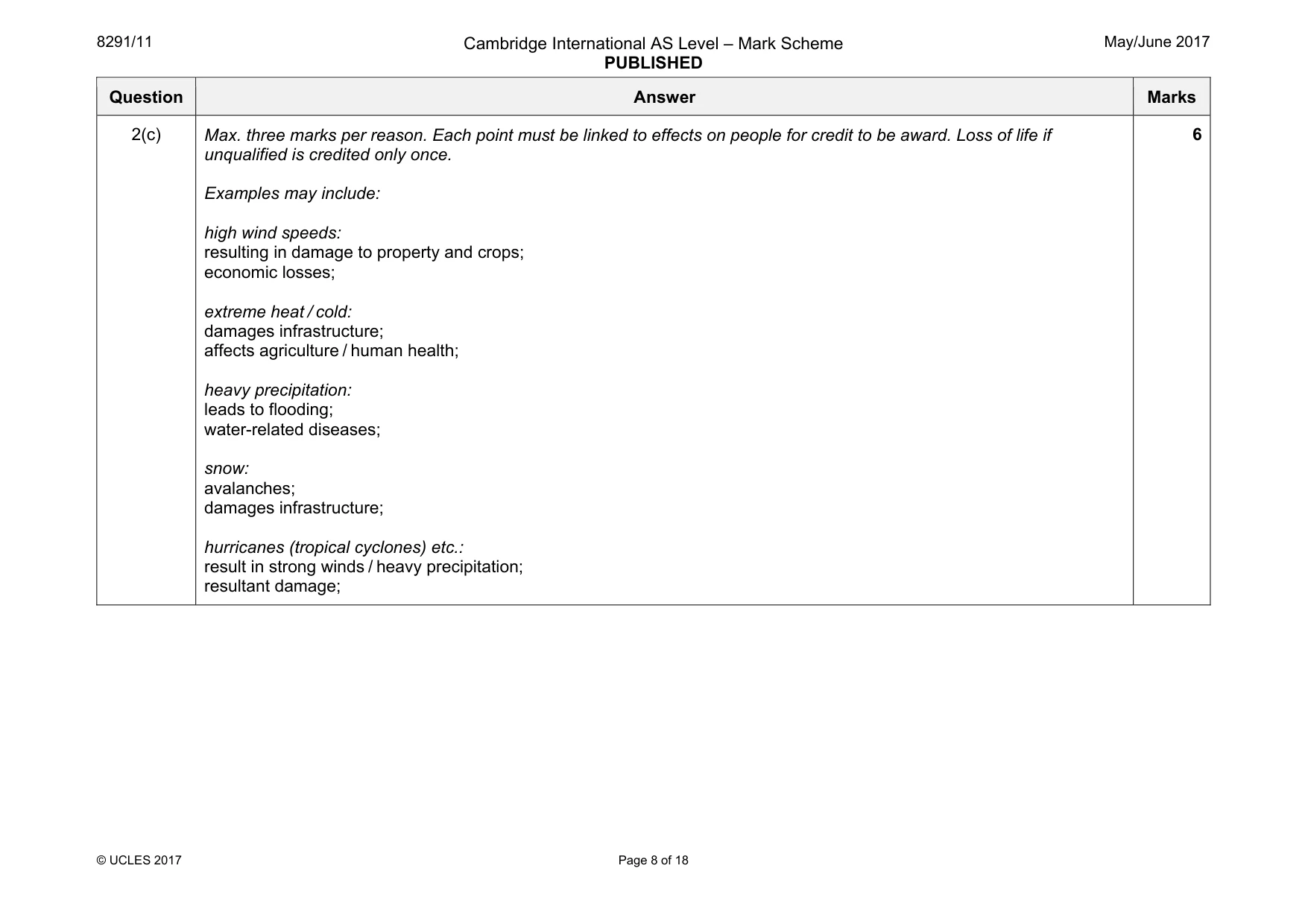
8291/11 Cambridge International AS Level – Mark Scheme PUBLISHED May/June 2017 © UCLES 2017 Page 8 of 18 Question Answer Marks 2(c) Max. three marks per reason. Each point must be linked to effects on people for credit to be award. Loss of life if unqualified is credited only once. Examples may include: high wind speeds: resulting in damage to property and crops; economic losses; extreme heat / cold: damages infrastructure; affects agriculture / human health; heavy precipitation: leads to flooding; water-related diseases; snow: avalanches; damages infrastructure; hurricanes (tropical cyclones) etc.: result in strong winds / heavy precipitation; resultant damage; 6
Mark scheme, page 9
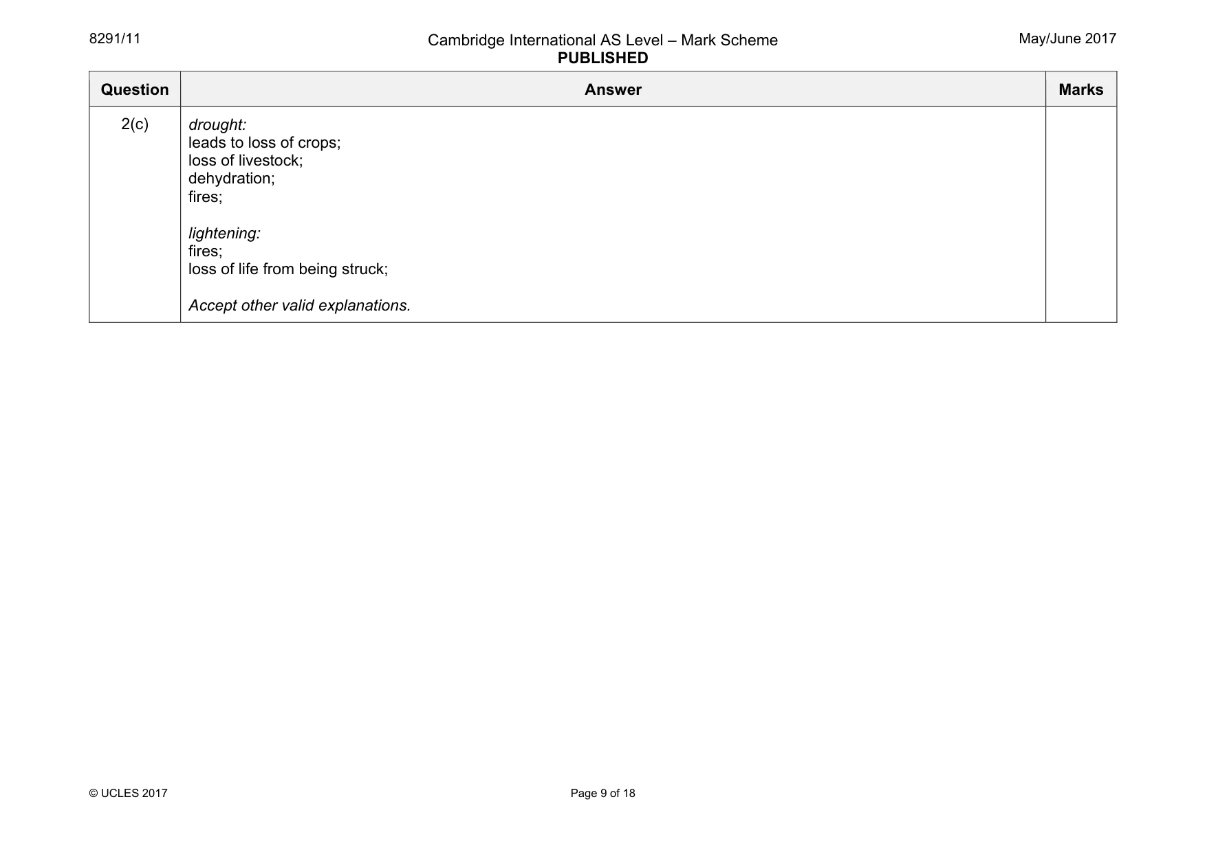
8291/11 Cambridge International AS Level – Mark Scheme PUBLISHED May/June 2017 © UCLES 2017 Page 9 of 18 Question Answer Marks 2(c) drought: leads to loss of crops; loss of livestock; dehydration; fires; lightening: fires; loss of life from being struck; Accept other valid explanations.
Mark scheme, page 10
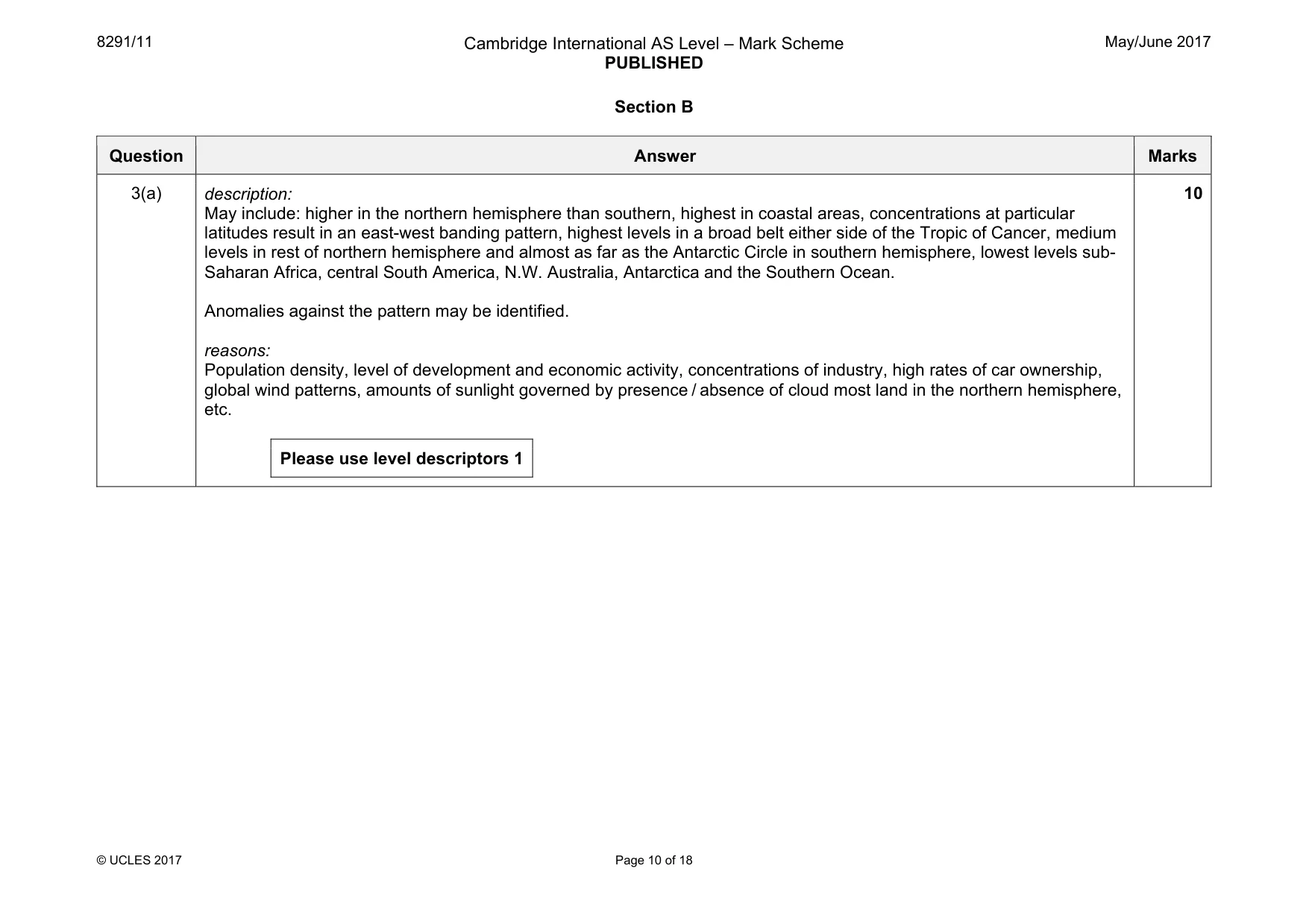
8291/11 Cambridge International AS Level – Mark Scheme PUBLISHED May/June 2017 © UCLES 2017 Page 10 of 18 Section B Question Answer Marks 3(a) description: May include: higher in the northern hemisphere than southern, highest in coastal areas, concentrations at particular latitudes result in an east-west banding pattern, highest levels in a broad belt either side of the Tropic of Cancer, medium levels in rest of northern hemisphere and almost as far as the Antarctic Circle in southern hemisphere, lowest levels sub- Saharan Africa, central South America, N.W. Australia, Antarctica and the Southern Ocean. Anomalies against the pattern may be identified. reasons: Population density, level of development and economic activity, concentrations of industry, high rates of car ownership, global wind patterns, amounts of sunlight governed by presence / absence of cloud most land in the northern hemisphere, etc. Please use level descriptors 1 10
Mark scheme, page 11
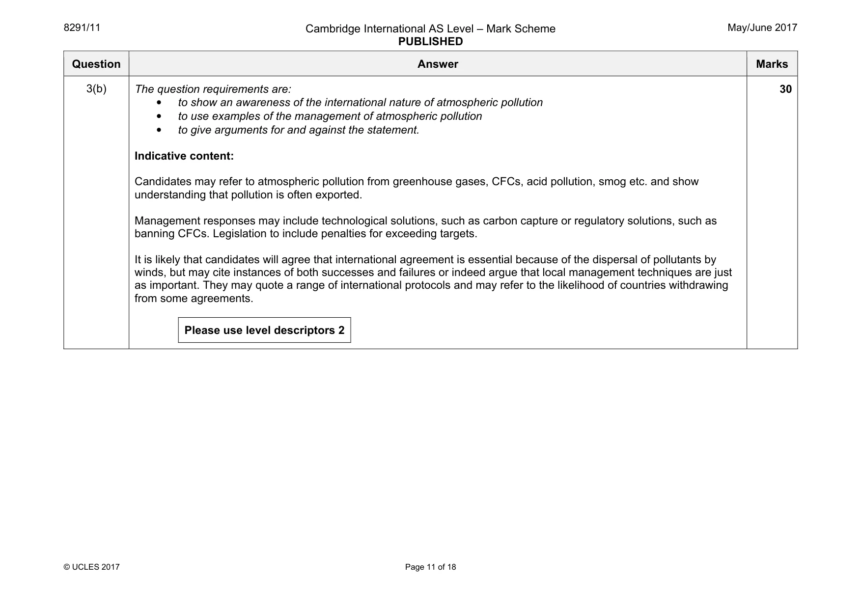
8291/11 Cambridge International AS Level – Mark Scheme PUBLISHED May/June 2017 © UCLES 2017 Page 11 of 18 Question Answer Marks 3(b) The question requirements are: • to show an awareness of the international nature of atmospheric pollution • to use examples of the management of atmospheric pollution • to give arguments for and against the statement. Indicative content: Candidates may refer to atmospheric pollution from greenhouse gases, CFCs, acid pollution, smog etc. and show understanding that pollution is often exported. Management responses may include technological solutions, such as carbon capture or regulatory solutions, such as banning CFCs. Legislation to include penalties for exceeding targets. It is likely that candidates will agree that international agreement is essential because of the dispersal of pollutants by winds, but may cite instances of both successes and failures or indeed argue that local management techniques are just as important. They may quote a range of international protocols and may refer to the likelihood of countries withdrawing from some agreements. Please use level descriptors 2 30
Mark scheme, page 12
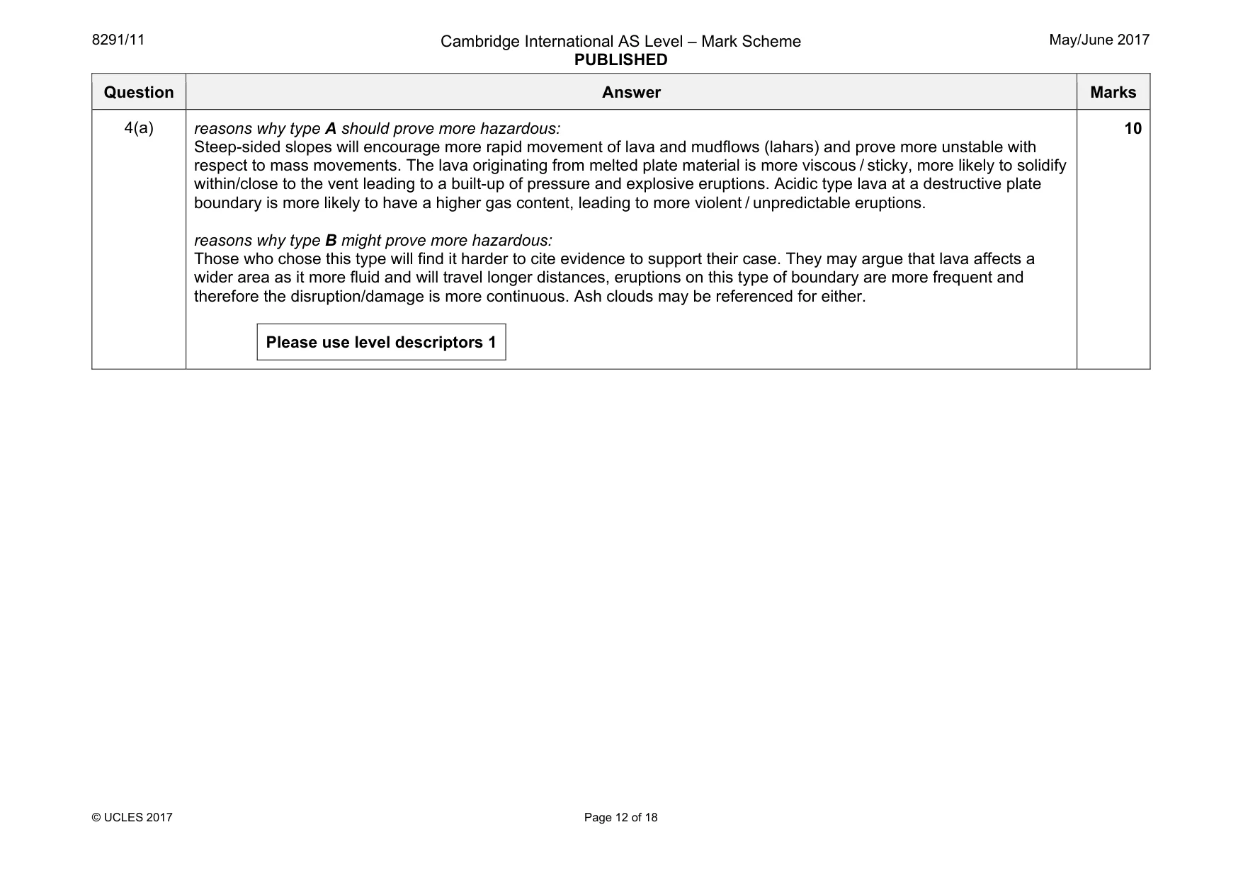
8291/11 Cambridge International AS Level – Mark Scheme PUBLISHED May/June 2017 © UCLES 2017 Page 12 of 18 Question Answer Marks 4(a) reasons why type A should prove more hazardous: Steep-sided slopes will encourage more rapid movement of lava and mudflows (lahars) and prove more unstable with respect to mass movements. The lava originating from melted plate material is more viscous / sticky, more likely to solidify within/close to the vent leading to a built-up of pressure and explosive eruptions. Acidic type lava at a destructive plate boundary is more likely to have a higher gas content, leading to more violent / unpredictable eruptions. reasons why type B might prove more hazardous: Those who chose this type will find it harder to cite evidence to support their case. They may argue that lava affects a wider area as it more fluid and will travel longer distances, eruptions on this type of boundary are more frequent and therefore the disruption/damage is more continuous. Ash clouds may be referenced for either. Please use level descriptors 1 10
Mark scheme, page 13
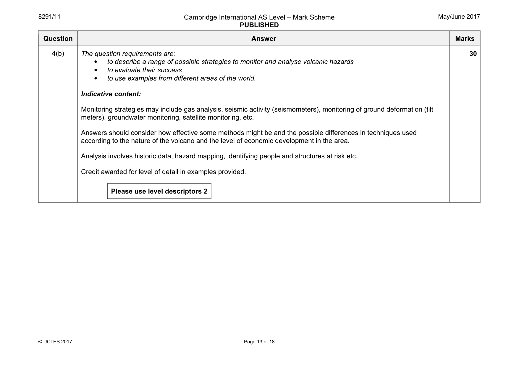
8291/11 Cambridge International AS Level – Mark Scheme PUBLISHED May/June 2017 © UCLES 2017 Page 13 of 18 Question Answer Marks 4(b) The question requirements are: • to describe a range of possible strategies to monitor and analyse volcanic hazards • to evaluate their success • to use examples from different areas of the world. Indicative content: Monitoring strategies may include gas analysis, seismic activity (seismometers), monitoring of ground deformation (tilt meters), groundwater monitoring, satellite monitoring, etc. Answers should consider how effective some methods might be and the possible differences in techniques used according to the nature of the volcano and the level of economic development in the area. Analysis involves historic data, hazard mapping, identifying people and structures at risk etc. Credit awarded for level of detail in examples provided. Please use level descriptors 2 30
Mark scheme, page 14
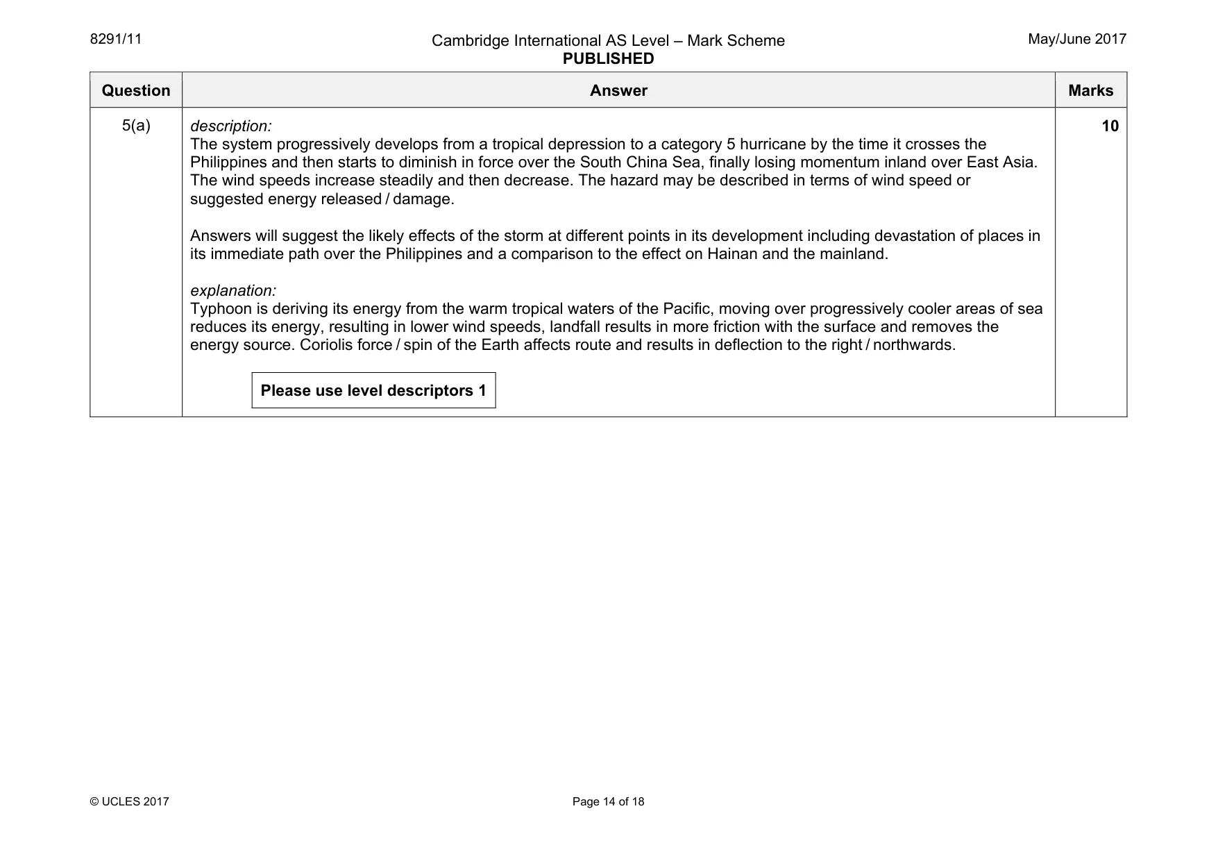
8291/11 Cambridge International AS Level – Mark Scheme PUBLISHED May/June 2017 © UCLES 2017 Page 14 of 18 Question Answer Marks 5(a) description: The system progressively develops from a tropical depression to a category 5 hurricane by the time it crosses the Philippines and then starts to diminish in force over the South China Sea, finally losing momentum inland over East Asia. The wind speeds increase steadily and then decrease. The hazard may be described in terms of wind speed or suggested energy released / damage. Answers will suggest the likely effects of the storm at different points in its development including devastation of places in its immediate path over the Philippines and a comparison to the effect on Hainan and the mainland. explanation: Typhoon is deriving its energy from the warm tropical waters of the Pacific, moving over progressively cooler areas of sea reduces its energy, resulting in lower wind speeds, landfall results in more friction with the surface and removes the energy source. Coriolis force / spin of the Earth affects route and results in deflection to the right / northwards. Please use level descriptors 1 10
Mark scheme, page 15
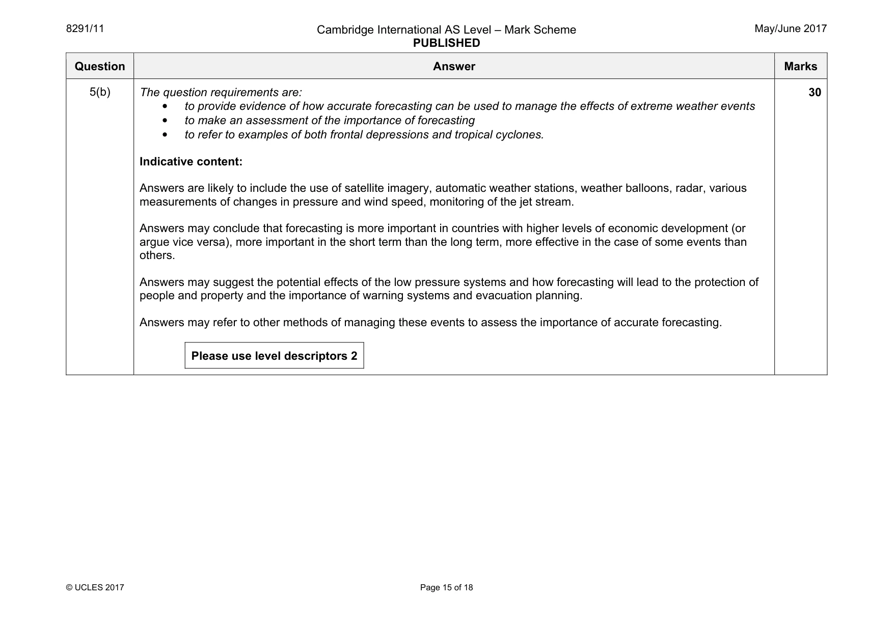
8291/11 Cambridge International AS Level – Mark Scheme PUBLISHED May/June 2017 © UCLES 2017 Page 15 of 18 Question Answer Marks 5(b) The question requirements are: • to provide evidence of how accurate forecasting can be used to manage the effects of extreme weather events • to make an assessment of the importance of forecasting • to refer to examples of both frontal depressions and tropical cyclones. Indicative content: Answers are likely to include the use of satellite imagery, automatic weather stations, weather balloons, radar, various measurements of changes in pressure and wind speed, monitoring of the jet stream. Answers may conclude that forecasting is more important in countries with higher levels of economic development (or argue vice versa), more important in the short term than the long term, more effective in the case of some events than others. Answers may suggest the potential effects of the low pressure systems and how forecasting will lead to the protection of people and property and the importance of warning systems and evacuation planning. Answers may refer to other methods of managing these events to assess the importance of accurate forecasting. Please use level descriptors 2 30
Mark scheme, page 16
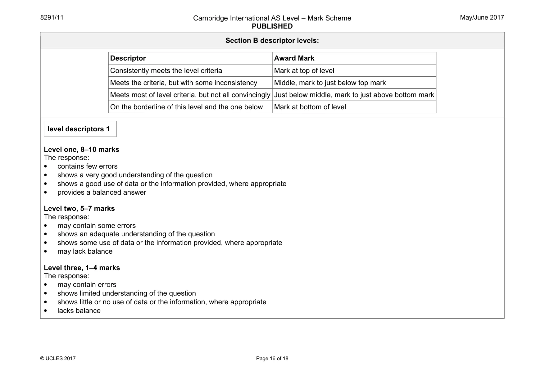
8291/11 Cambridge International AS Level – Mark Scheme PUBLISHED May/June 2017 © UCLES 2017 Page 16 of 18 Section B descriptor levels: Descriptor Award Mark Consistently meets the level criteria Mark at top of level Meets the criteria, but with some inconsistency Middle, mark to just below top mark Meets most of level criteria, but not all convincingly Just below middle, mark to just above bottom mark On the borderline of this level and the one below Mark at bottom of level level descriptors 1 Level one, 8–10 marks The response: • contains few errors • shows a very good understanding of the question • shows a good use of data or the information provided, where appropriate • provides a balanced answer Level two, 5–7 marks The response: • may contain some errors • shows an adequate understanding of the question • shows some use of data or the information provided, where appropriate • may lack balance Level three, 1–4 marks The response: • may contain errors • shows limited understanding of the question • shows little or no use of data or the information, where appropriate • lacks balance
Mark scheme, page 17
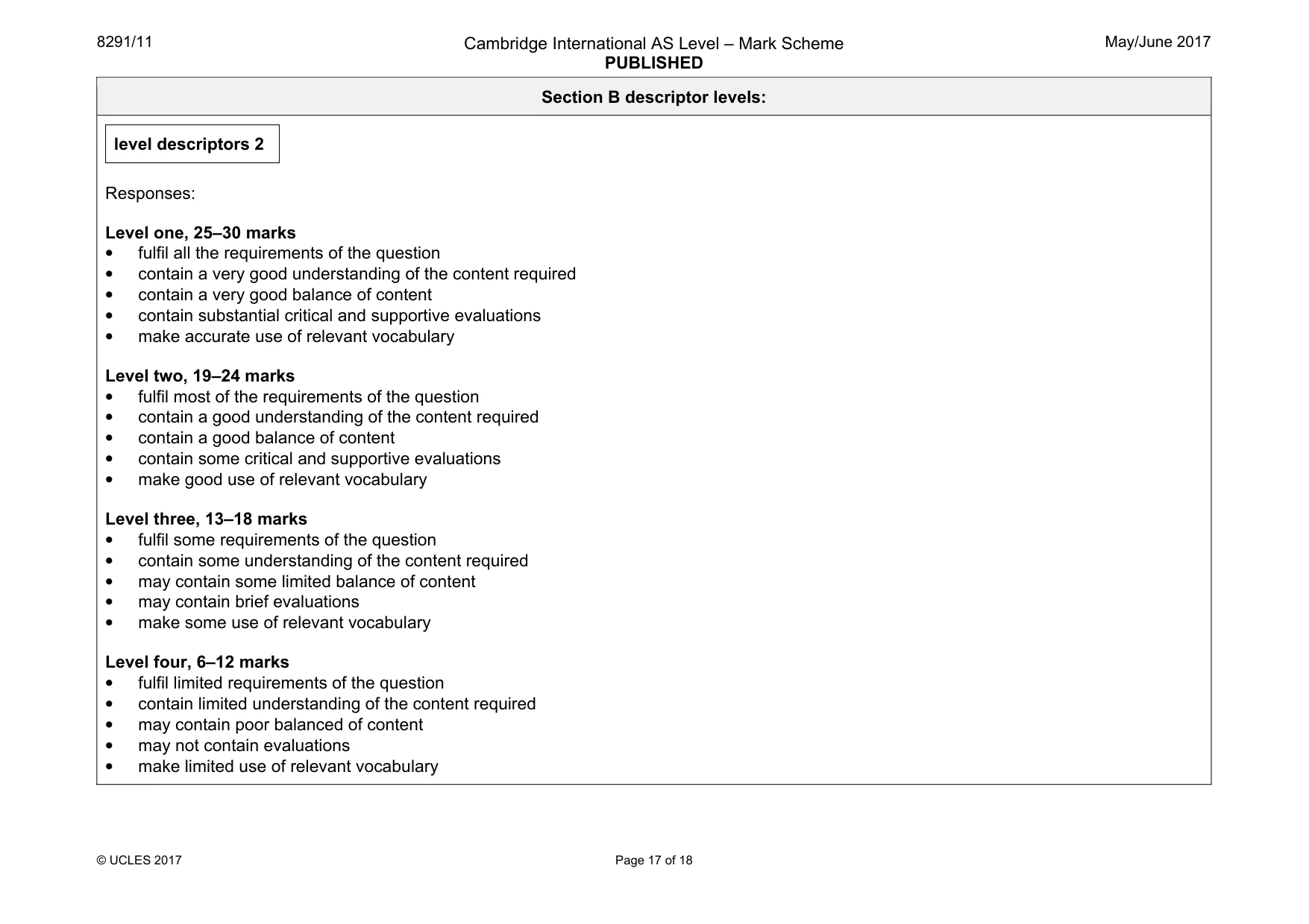
8291/11 Cambridge International AS Level – Mark Scheme PUBLISHED May/June 2017 © UCLES 2017 Page 17 of 18 Section B descriptor levels: level descriptors 2 Responses: Level one, 25–30 marks • fulfil all the requirements of the question • contain a very good understanding of the content required • contain a very good balance of content • contain substantial critical and supportive evaluations • make accurate use of relevant vocabulary Level two, 19–24 marks • fulfil most of the requirements of the question • contain a good understanding of the content required • contain a good balance of content • contain some critical and supportive evaluations • make good use of relevant vocabulary Level three, 13–18 marks • fulfil some requirements of the question • contain some understanding of the content required • may contain some limited balance of content • may contain brief evaluations • make some use of relevant vocabulary Level four, 6–12 marks • fulfil limited requirements of the question • contain limited understanding of the content required • may contain poor balanced of content • may not contain evaluations • make limited use of relevant vocabulary
Mark scheme, page 18
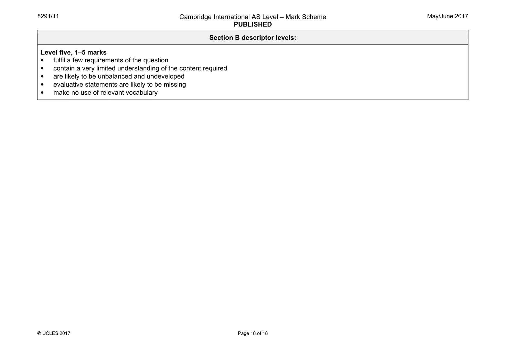
8291/11 Cambridge International AS Level – Mark Scheme PUBLISHED May/June 2017 © UCLES 2017 Page 18 of 18 Section B descriptor levels: Level five, 1–5 marks • fulfil a few requirements of the question • contain a very limited understanding of the content required • are likely to be unbalanced and undeveloped • evaluative statements are likely to be missing • make no use of relevant vocabulary
What you needed in this session
Cambridge’s own grade thresholds for 2017 May/June, Paper 1 · Variant 1. A higher threshold means an easier paper — the bar moves with how the cohort did.