Cambridge IGCSE Geography 0460 — 2021 May/June Paper 1 · Variant 3
0460/13/M/J/21 · 75 marks · ≈84 min
The question paper and its mark scheme, free to read here and free to download. This is Cambridge’s own paper, exactly as it was sat.
Question paper36 pages




Mark scheme21 pages
Answers below. Sit the paper first if you are practising.
Paper as text
Question paper, page 1
This document has 36 pages. Any blank pages are indicated. Cambridge IGCSE™ DC (MS/CT) 197871/6 © UCLES 2021 [Turn over GEOGRAPHY 0460/13 Paper 1 Geographical Themes May/June 2021 1 hour 45 minutes You must answer on the question paper. You will need: Insert (enclosed) Ruler Calculator Protractor INSTRUCTIONS ● Answer three questions in total, one from each section. ● Use a black or dark blue pen. You may use an HB pencil for any diagrams or graphs. ● Write your name, centre number and candidate number in the boxes at the top of the page. ● Write your answer to each question in the space provided. ● Do not use an erasable pen or correction fluid. ● Do not write on any bar codes. ● If additional space is needed, you should use the lined pages at the end of this booklet; the question number or numbers must be clearly shown. INFORMATION ● The total mark for this paper is 75. ● The number of marks for each question or part question is shown in brackets [ ]. ● The insert contains additional resources referred to in the questions. Definitions MEDCs – More Economically Developed Countries LEDCs – Less Economically Developed Countries * 3 4 9 3 0 6 1 7 7 1 *
Question paper, page 2
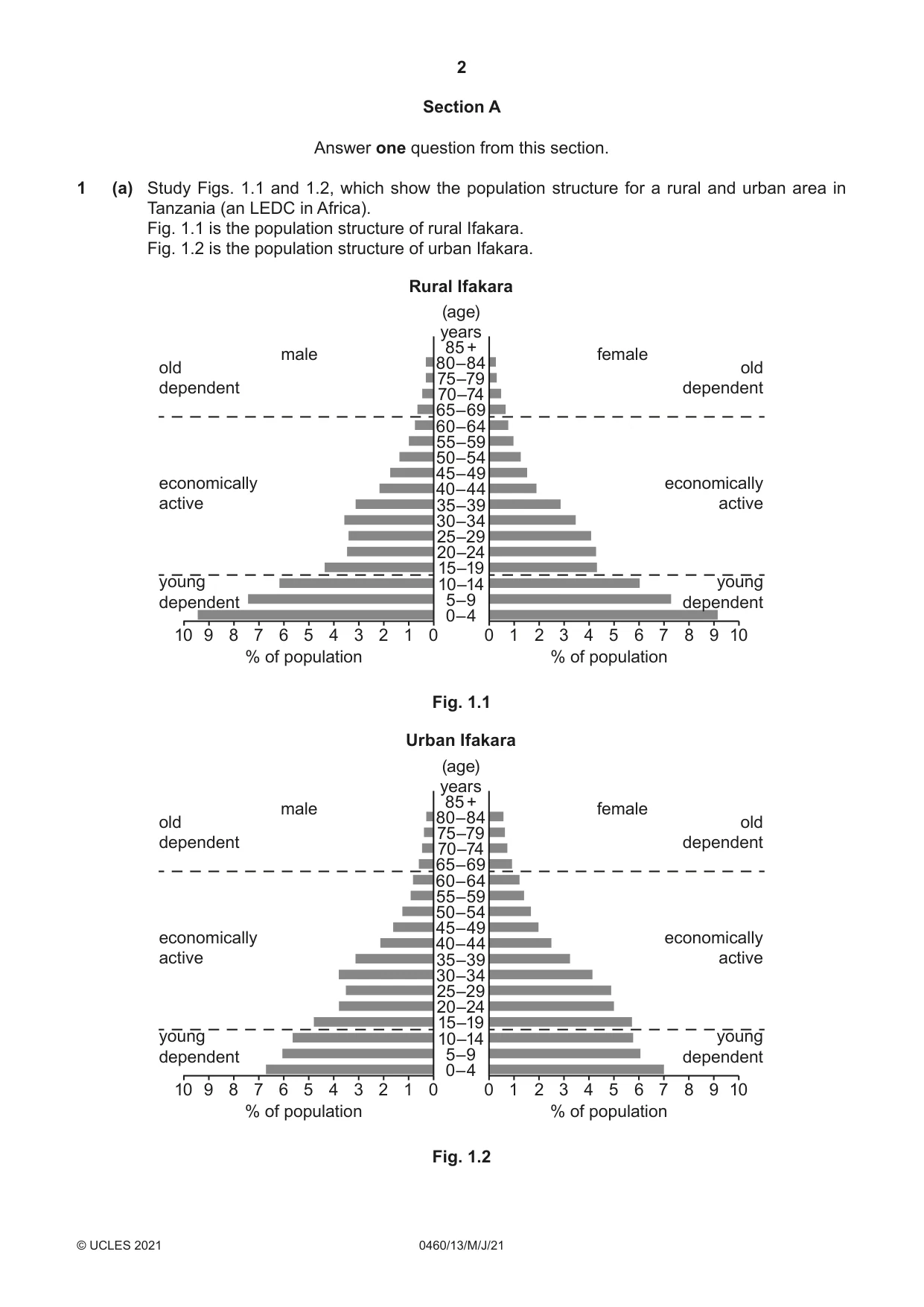
2 0460/13/M/J/21 © UCLES 2021 Section A Answer one question from this section. 1 (a) Study Figs. 1.1 and 1.2, which show the population structure for a rural and urban area in Tanzania (an LEDC in Africa). Fig. 1.1 is the population structure of rural Ifakara. Fig. 1.2 is the population structure of urban Ifakara. 0 1 2 3 4 5 6 7 8 9 10 % of population 0 1 2 3 4 5 6 7 8 9 10 % of population 0–4 5–9 10–14 15–19 20–24 25–29 30–34 35–39 40–44 45–49 50–54 55–59 60–64 65–69 70–74 75–79 80–84 85 + male female (age) years Rural Ifakara old dependent young dependent economically active old dependent young dependent economically active Fig. 1.1 0 1 2 3 4 5 6 7 8 9 10 % of population 0 1 2 3 4 5 6 7 8 9 10 % of population 0–4 5–9 10–14 15–19 20–24 25–29 30–34 35–39 40–44 45–49 50–54 55–59 60–64 65–69 70–74 75–79 80–84 85 + male female (age) years Urban Ifakara old dependent young dependent economically active old dependent young dependent economically active Fig. 1.2
Question paper, page 3
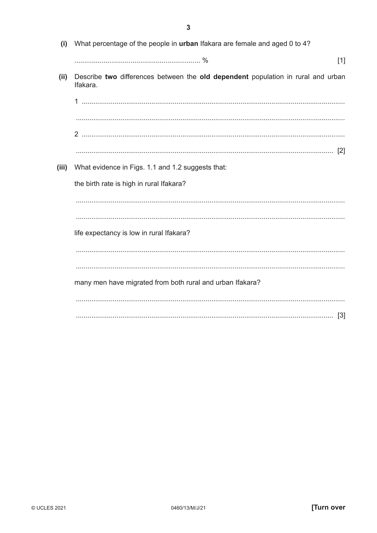
3 0460/13/M/J/21 © UCLES 2021 [Turn over (i) What percentage of the people in urban Ifakara are female and aged 0 to 4? … % [1] (ii) Describe two differences between the old dependent population in rural and urban Ifakara. 1 … … 2 … … [2] (iii) What evidence in Figs. 1.1 and 1.2 suggests that: the birth rate is high in rural Ifakara? … … life expectancy is low in rural Ifakara? … … many men have migrated from both rural and urban Ifakara? … … [3]
Question paper, page 4
4 0460/13/M/J/21 © UCLES 2021 (iv) Suggest reasons why birth rates are high in rural areas of Tanzania. … … … … … … … … [4]
Question paper, page 5
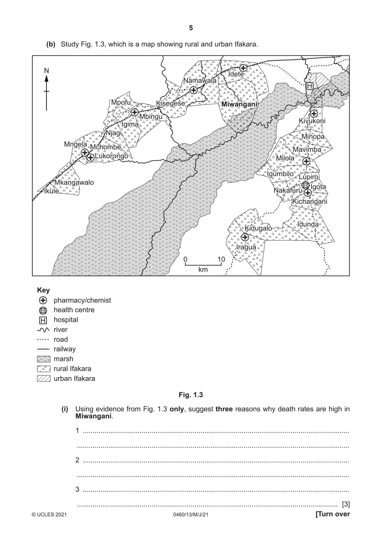
5 0460/13/M/J/21 © UCLES 2021 [Turn over (b) Study Fig. 1.3, which is a map showing rural and urban Ifakara. 0 10 km N H H H H Key pharmacy/chemist health centre hospital river road railway marsh rural Ifakara urban Ifakara Miwangani Kisegese Namawala Idete Mbingu Mpofu Igima Njagi Mchombe Mkangawalo Ikule Mngela Lukorongo Kivukoni Minopa Mavimba Milola Igumbilo Lupiro Nakafuru Idunda Kidugalo Iragua Igota Kichangant Miwangani Kisegese Namawala Idete Mbingu Mpofu Igima Njagi Mchombe Mkangawalo Ikule Mngela Lukorongo Kivukoni Minopa Mavimba Milola Igumbilo Lupiro Nakafuru Idunda Kidugalo Iragua Igota Kichangani Fig. 1.3 (i) Using evidence from Fig. 1.3 only, suggest three reasons why death rates are high in Miwangani. 1 … … 2 … … 3 … … [3]
Question paper, page 6
6 0460/13/M/J/21 © UCLES 2021 (ii) Some parts of Tanzania are over-populated. Describe the problems faced by people living in areas which are over-populated. … … … … … … … … … … [5]
Question paper, page 7
7 0460/13/M/J/21 © UCLES 2021 [Turn over (c) Describe the problems caused by a large dependent population in a named country you have studied. Name of country … … … … … … … … … … … … … … … … … … … … … … … … … … [7] [Total: 25]
Question paper, page 8
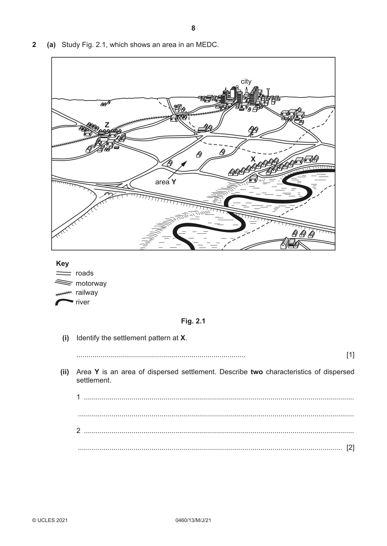
8 0460/13/M/J/21 © UCLES 2021 2 (a) Study Fig. 2.1, which shows an area in an MEDC. river railway motorway roads Key X Z area Y city Fig. 2.1 (i) Identify the settlement pattern at X. … [1] (ii) Area Y is an area of dispersed settlement. Describe two characteristics of dispersed settlement. 1 … … 2 … … [2]
Question paper, page 9
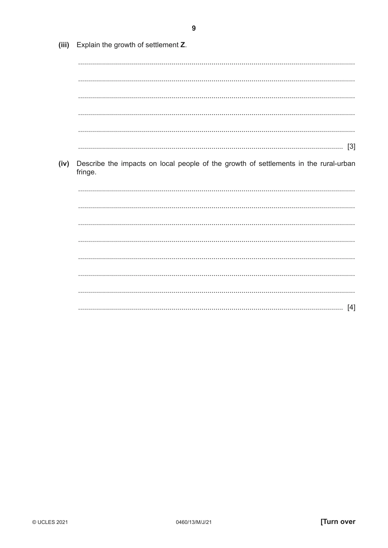
9 0460/13/M/J/21 © UCLES 2021 [Turn over (iii) Explain the growth of settlement Z. … … … … … … [3] (iv) Describe the impacts on local people of the growth of settlements in the rural-urban fringe. … … … … … … … … [4]
Question paper, page 10
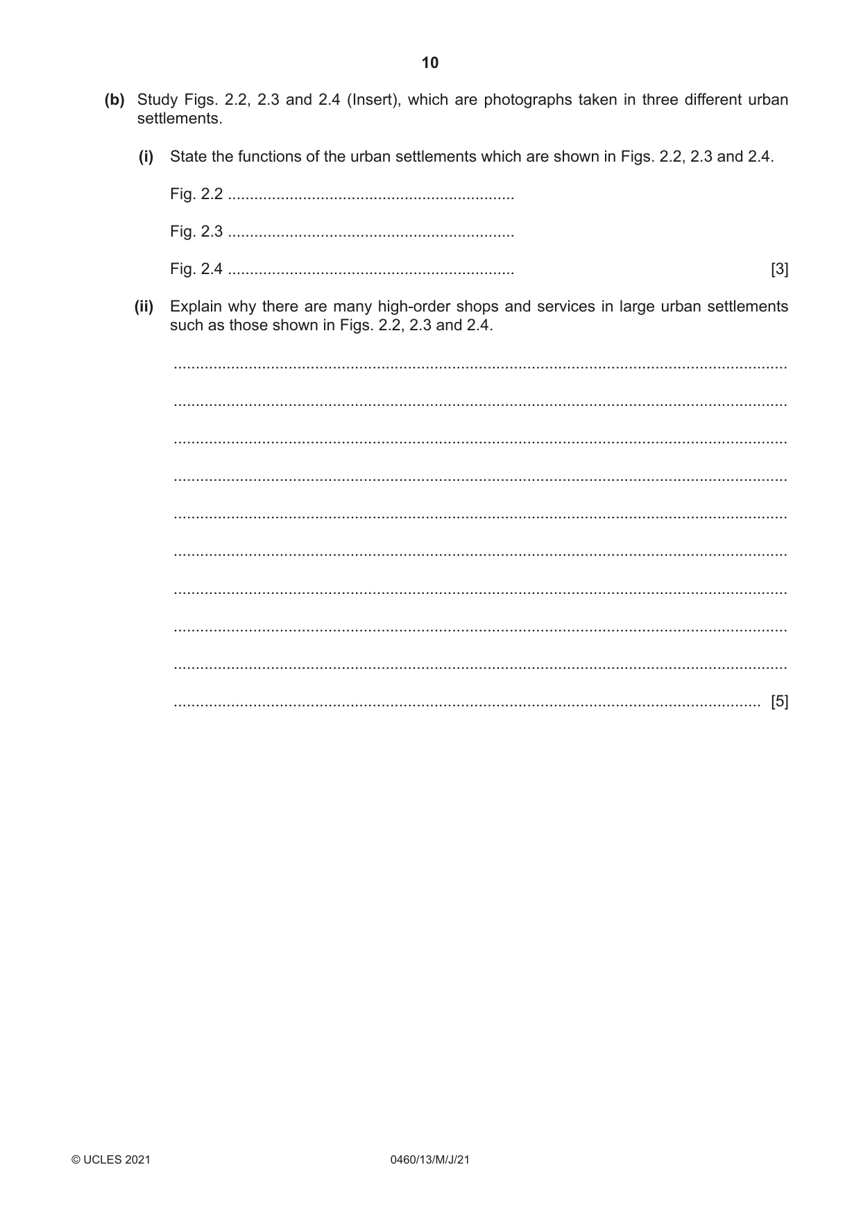
10 0460/13/M/J/21 © UCLES 2021 (b) Study Figs. 2.2, 2.3 and 2.4 (Insert), which are photographs taken in three different urban settlements. (i) State the functions of the urban settlements which are shown in Figs. 2.2, 2.3 and 2.4. Fig. 2.2 … Fig. 2.3 … Fig. 2.4 … [3] (ii) Explain why there are many high-order shops and services in large urban settlements such as those shown in Figs. 2.2, 2.3 and 2.4. … … … … … … … … … … [5]
Question paper, page 11
11 0460/13/M/J/21 © UCLES 2021 [Turn over (c) For a named urban area you have studied, describe one change in land use and explain why this change in land use has caused problems. Name of urban area … … … … … … … … … … … … … … … … … … … … … … … … … … [7] [Total: 25]
Question paper, page 12
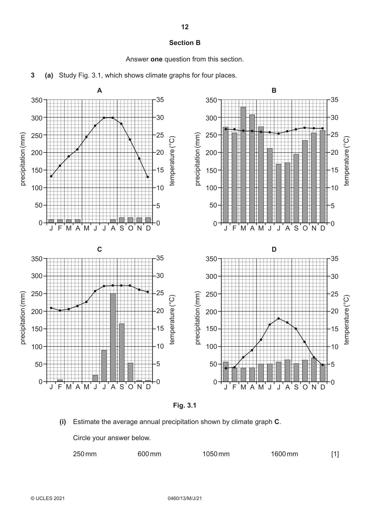
12 0460/13/M/J/21 © UCLES 2021 Section B Answer one question from this section. 3 (a) Study Fig. 3.1, which shows climate graphs for four places. A 0 50 100 150 200 250 300 350 0 5 10 15 20 25 30 35 J F M A M J J A S O N D precipitation (mm) temperature (°C) B 0 50 100 150 200 250 300 350 0 5 10 15 20 25 30 35 J F M A M J J A S O N D J F M A M J J A S O N D J F M A M J J A S O N D precipitation (mm) temperature (°C) C 0 50 100 150 200 250 300 350 0 5 10 15 20 25 30 35 precipitation (mm) temperature (°C) D 0 50 100 150 200 250 300 350 0 5 10 15 20 25 30 35 precipitation (mm) temperature (°C) Fig. 3.1 (i) Estimate the average annual precipitation shown by climate graph C. Circle your answer below. 250 mm 600 mm 1050 mm 1600 mm [1]
Question paper, page 13
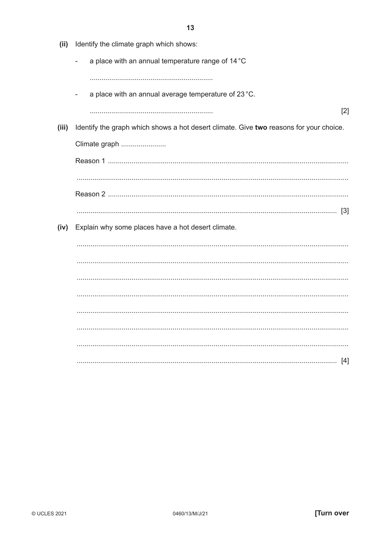
13 0460/13/M/J/21 © UCLES 2021 [Turn over (ii) Identify the climate graph which shows: - a place with an annual temperature range of 14 °C … - a place with an annual average temperature of 23 °C. … [2] (iii) Identify the graph which shows a hot desert climate. Give two reasons for your choice. Climate graph … Reason 1 … … Reason 2 … … [3] (iv) Explain why some places have a hot desert climate. … … … … … … … … [4]
Question paper, page 14
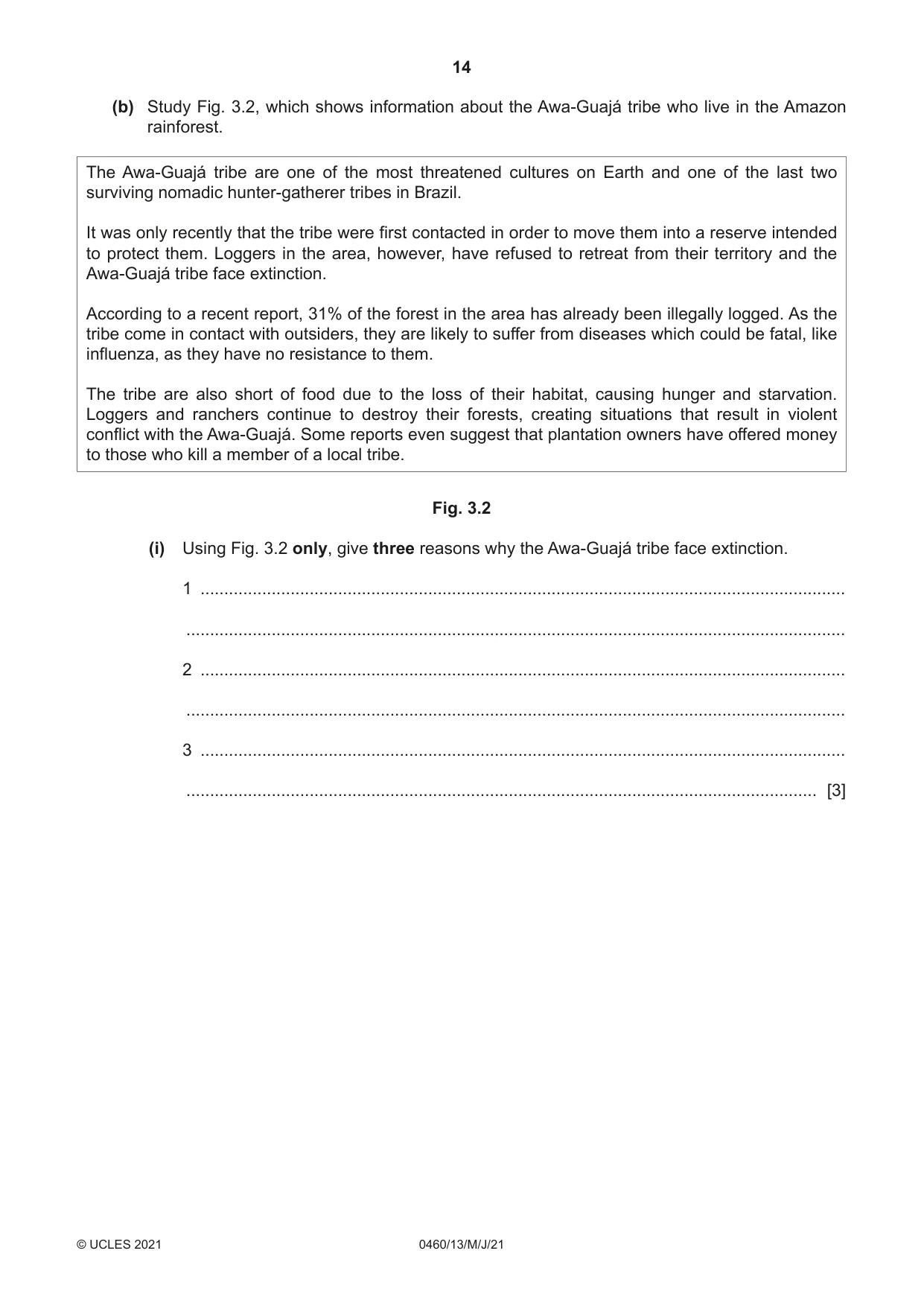
14 0460/13/M/J/21 © UCLES 2021 (b) Study Fig. 3.2, which shows information about the Awa-Guajá tribe who live in the Amazon rainforest. The Awa-Guajá tribe are one of the most threatened cultures on Earth and one of the last two surviving nomadic hunter-gatherer tribes in Brazil. It was only recently that the tribe were first contacted in order to move them into a reserve intended to protect them. Loggers in the area, however, have refused to retreat from their territory and the Awa-Guajá tribe face extinction. According to a recent report, 31% of the forest in the area has already been illegally logged. As the tribe come in contact with outsiders, they are likely to suffer from diseases which could be fatal, like influenza, as they have no resistance to them. The tribe are also short of food due to the loss of their habitat, causing hunger and starvation. Loggers and ranchers continue to destroy their forests, creating situations that result in violent conflict with the Awa-Guajá. Some reports even suggest that plantation owners have offered money to those who kill a member of a local tribe. Fig. 3.2 (i) Using Fig. 3.2 only, give three reasons why the Awa-Guajá tribe face extinction. 1 … … 2 … … 3 … … [3]
Question paper, page 15
15 0460/13/M/J/21 © UCLES 2021 [Turn over (ii) Explain why protecting the rainforest from deforestation is also important for the natural environment in the area where the Awa-Guajá tribe live. … … … … … … … … … … [5]
Question paper, page 16
16 0460/13/M/J/21 © UCLES 2021 (c) Explain why large scale deforestation of tropical rainforests threatens the global natural environment. You should refer to named places. … … … … … … … … … … … … … … … … … … … … … … … … … [7] [Total: 25]
Question paper, page 17
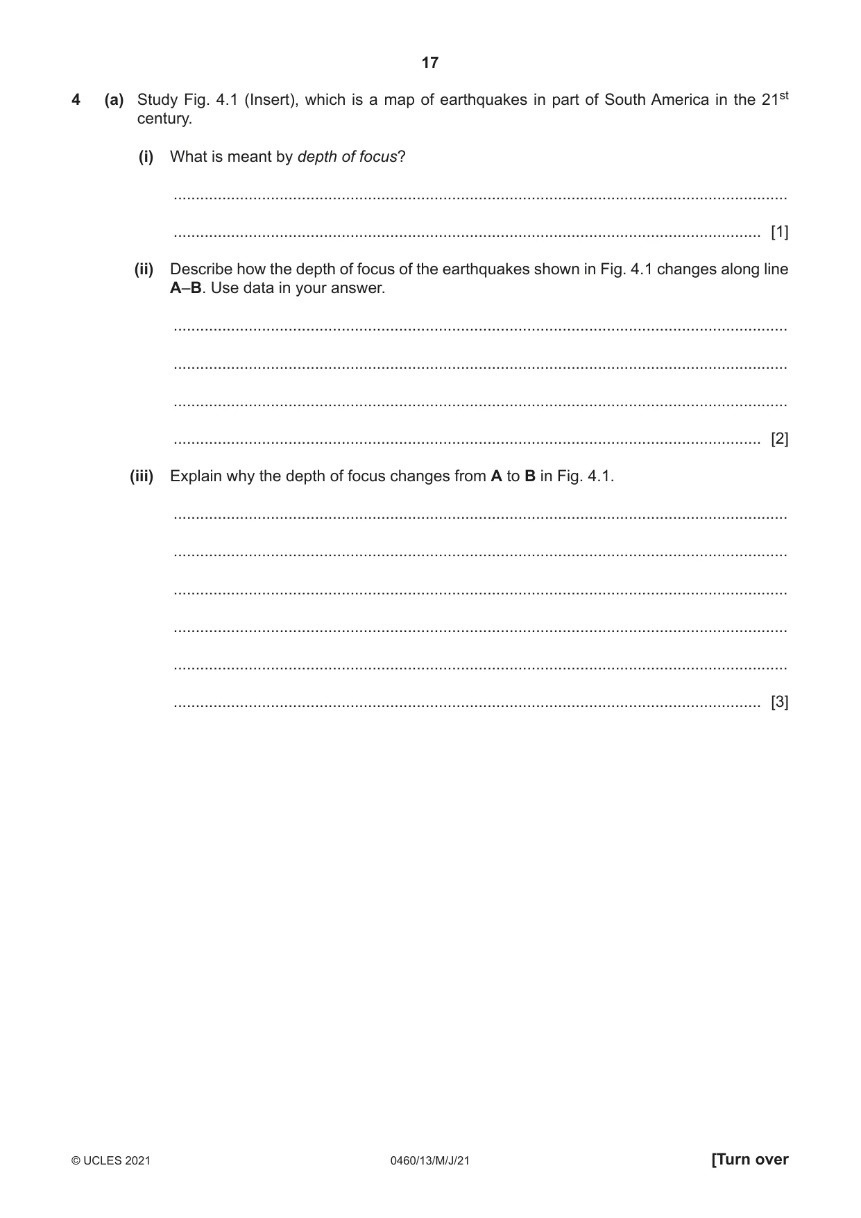
17 0460/13/M/J/21 © UCLES 2021 [Turn over 4 (a) Study Fig. 4.1 (Insert), which is a map of earthquakes in part of South America in the 21st century. (i) What is meant by depth of focus? … … [1] (ii) Describe how the depth of focus of the earthquakes shown in Fig. 4.1 changes along line A–B. Use data in your answer. … … … … [2] (iii) Explain why the depth of focus changes from A to B in Fig. 4.1. … … … … … … [3]
Question paper, page 18
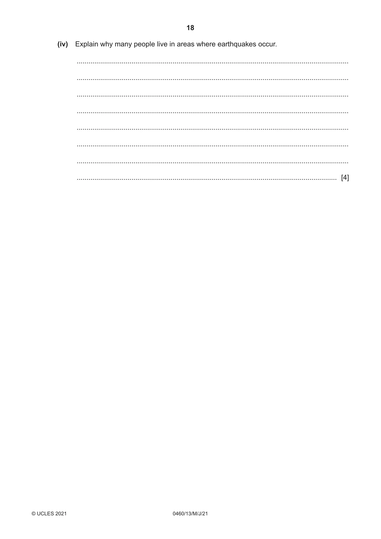
18 0460/13/M/J/21 © UCLES 2021 (iv) Explain why many people live in areas where earthquakes occur. … … … … … … … … [4]
Question paper, page 19
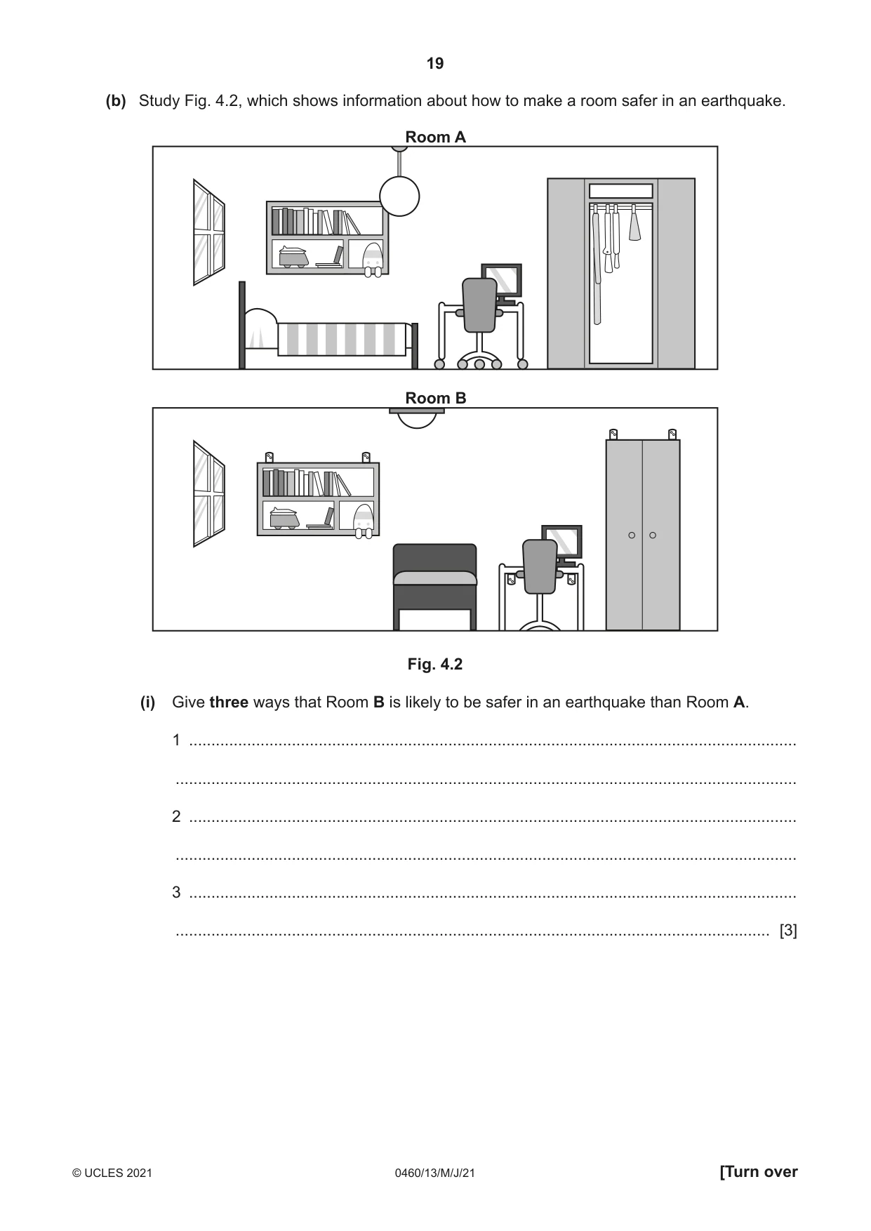
19 0460/13/M/J/21 © UCLES 2021 [Turn over (b) Study Fig. 4.2, which shows information about how to make a room safer in an earthquake. Room A Room B Fig. 4.2 (i) Give three ways that Room B is likely to be safer in an earthquake than Room A. 1 … … 2 … … 3 … … [3]
Question paper, page 20
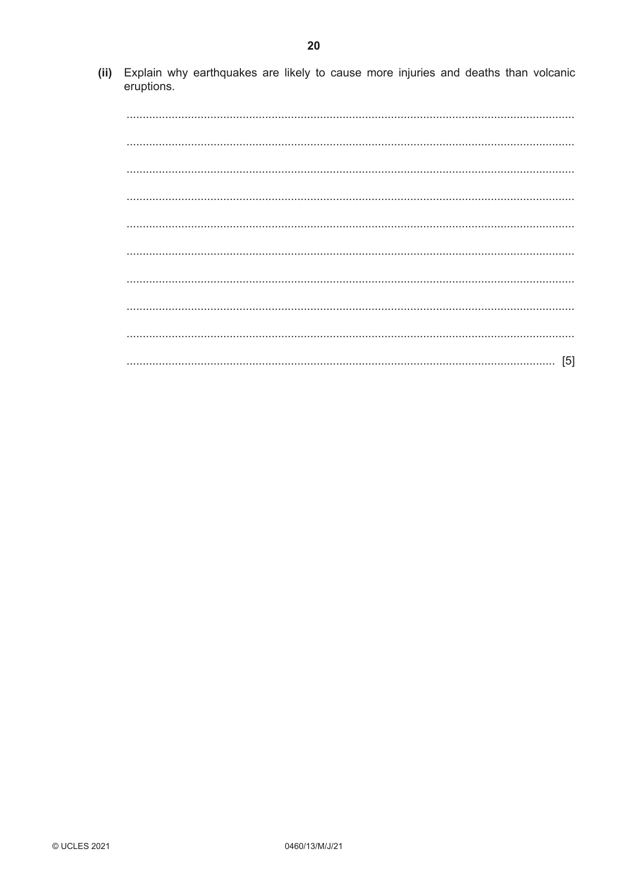
20 0460/13/M/J/21 © UCLES 2021 (ii) Explain why earthquakes are likely to cause more injuries and deaths than volcanic eruptions. … … … … … … … … … … [5]
Question paper, page 21
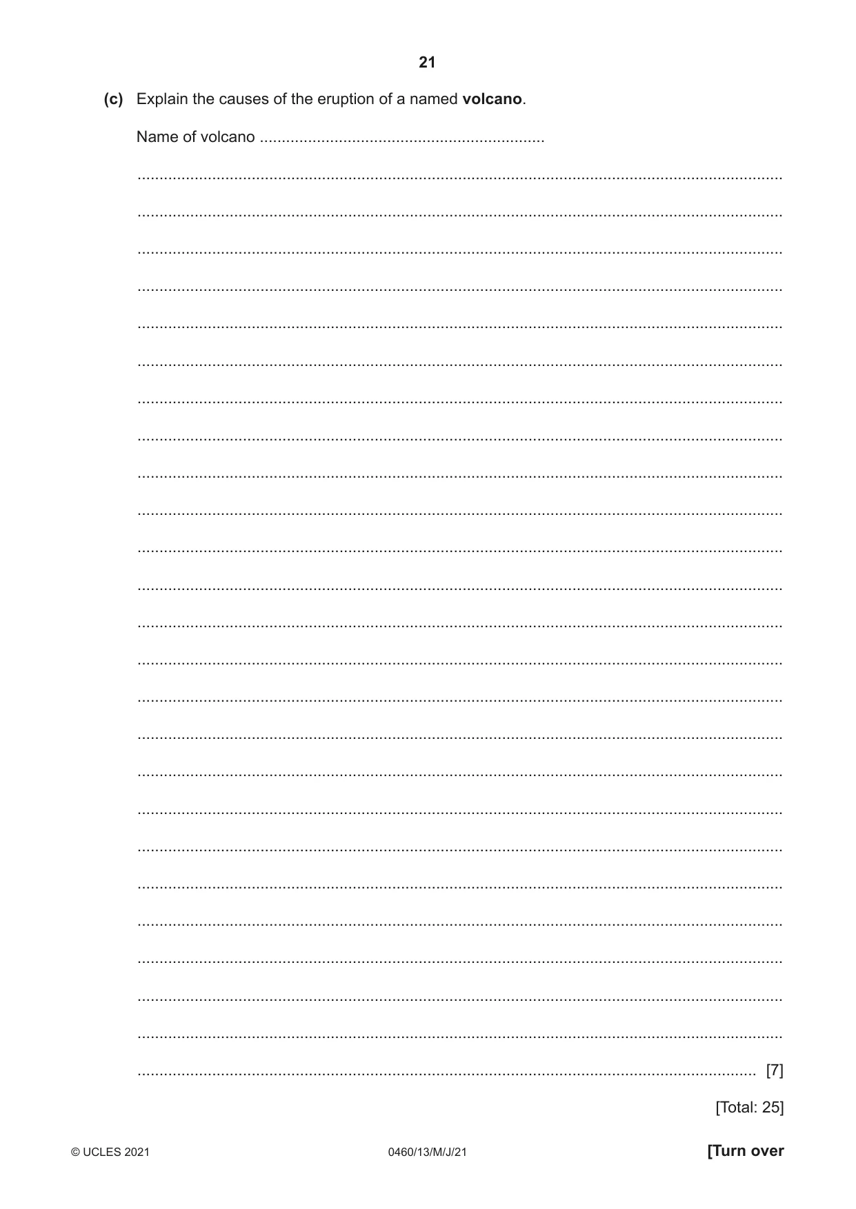
21 0460/13/M/J/21 © UCLES 2021 [Turn over (c) Explain the causes of the eruption of a named volcano. Name of volcano … … … … … … … … … … … … … … … … … … … … … … … … … … [7] [Total: 25]
Question paper, page 22
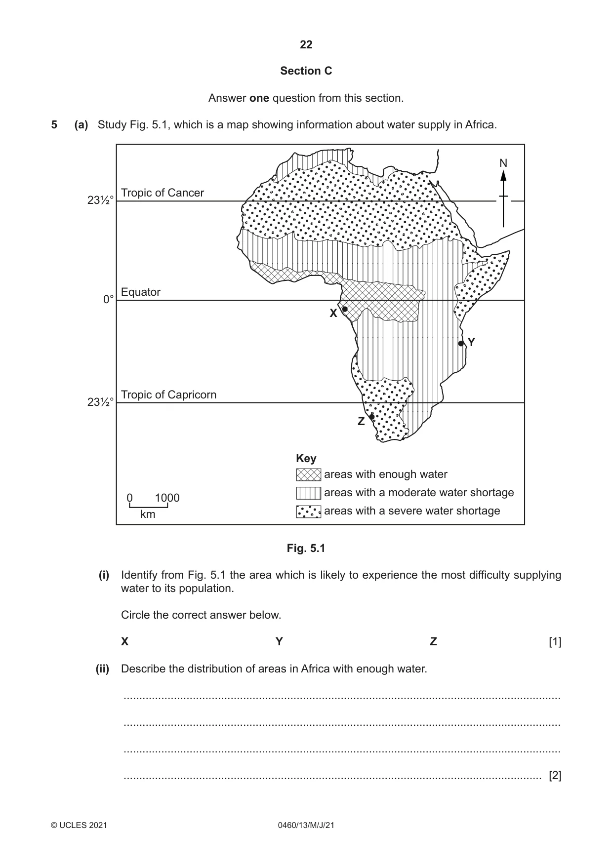
22 0460/13/M/J/21 © UCLES 2021 Section C Answer one question from this section. 5 (a) Study Fig. 5.1, which is a map showing information about water supply in Africa. Key areas with enough water areas with a moderate water shortage areas with a severe water shortage Tropic of Cancer Equator Tropic of Capricorn 23½° 0° 23½° 0 1000 km X Z Y N Fig. 5.1 (i) Identify from Fig. 5.1 the area which is likely to experience the most difficulty supplying water to its population. Circle the correct answer below. X Y Z [1] (ii) Describe the distribution of areas in Africa with enough water. … … … … [2]
Question paper, page 23
23 0460/13/M/J/21 © UCLES 2021 [Turn over (iii) Explain why many rural areas in LEDCs have a shortage of water. … … … … … … [3] (iv) Explain why it is important to increase the supply of clean water in rural areas in LEDCs. … … … … … … … … [4]
Question paper, page 24
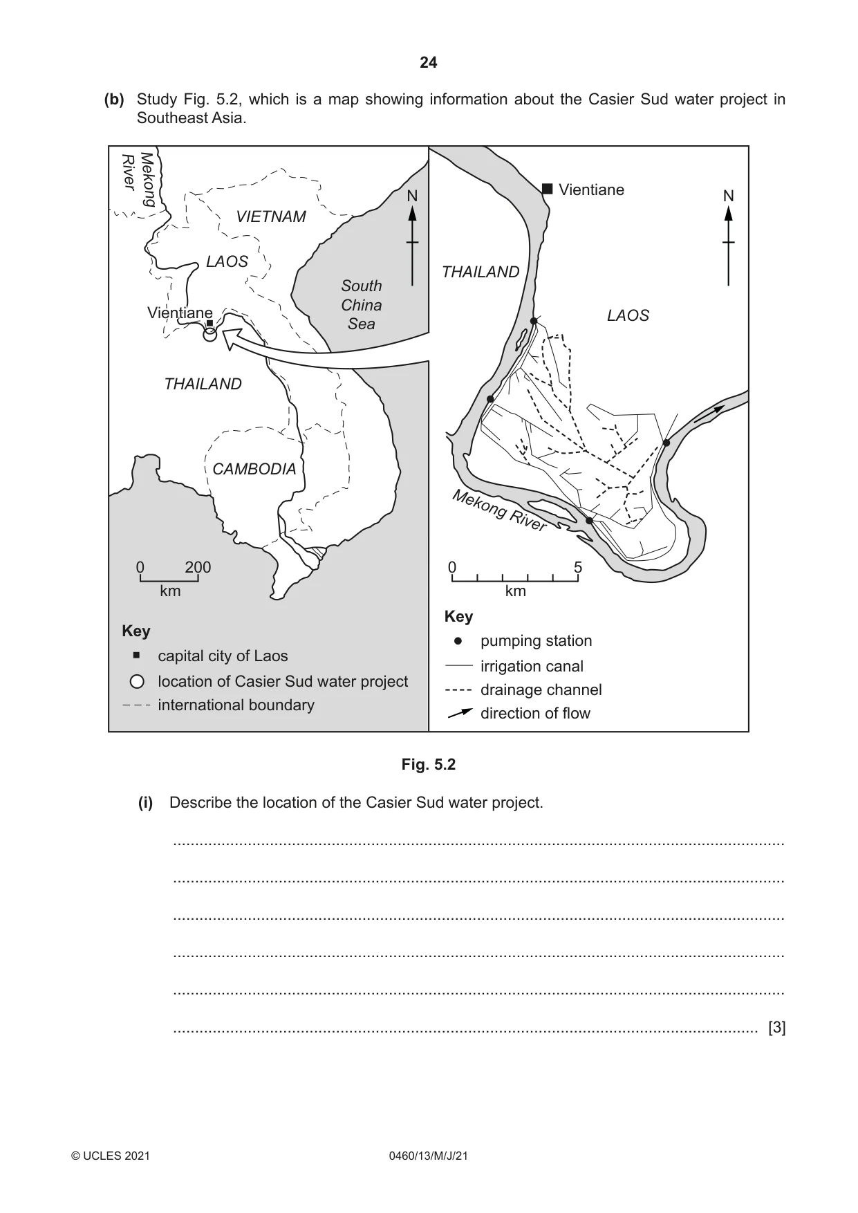
24 0460/13/M/J/21 © UCLES 2021 (b) Study Fig. 5.2, which is a map showing information about the Casier Sud water project in Southeast Asia. THAILAND THAILAND VIETNAM LAOS LAOS CAMBODIA South China Sea Mekong River Mekong River Vientiane Vientiane Vientiane 0 200 km 0 5 km N N Key capital city of Laos location of Casier Sud water project Key pumping station irrigation canal drainage channel direction of flow international boundary Fig. 5.2 (i) Describe the location of the Casier Sud water project. … … … … … … [3]
Question paper, page 25
25 0460/13/M/J/21 © UCLES 2021 [Turn over (ii) Explain how the Casier Sud water project is likely to improve agricultural production in the area. … … … … … … … … … … [5]
Question paper, page 26
26 0460/13/M/J/21 © UCLES 2021 (c) For a named country or area you have studied, explain how clean drinking water is supplied. Name of country or area … … … … … … … … … … … … … … … … … … … … … … … … … … [7] [Total: 25]
Question paper, page 27
27 0460/13/M/J/21 © UCLES 2021 [Turn over TURN PAGE FOR QUESTION 6
Question paper, page 28
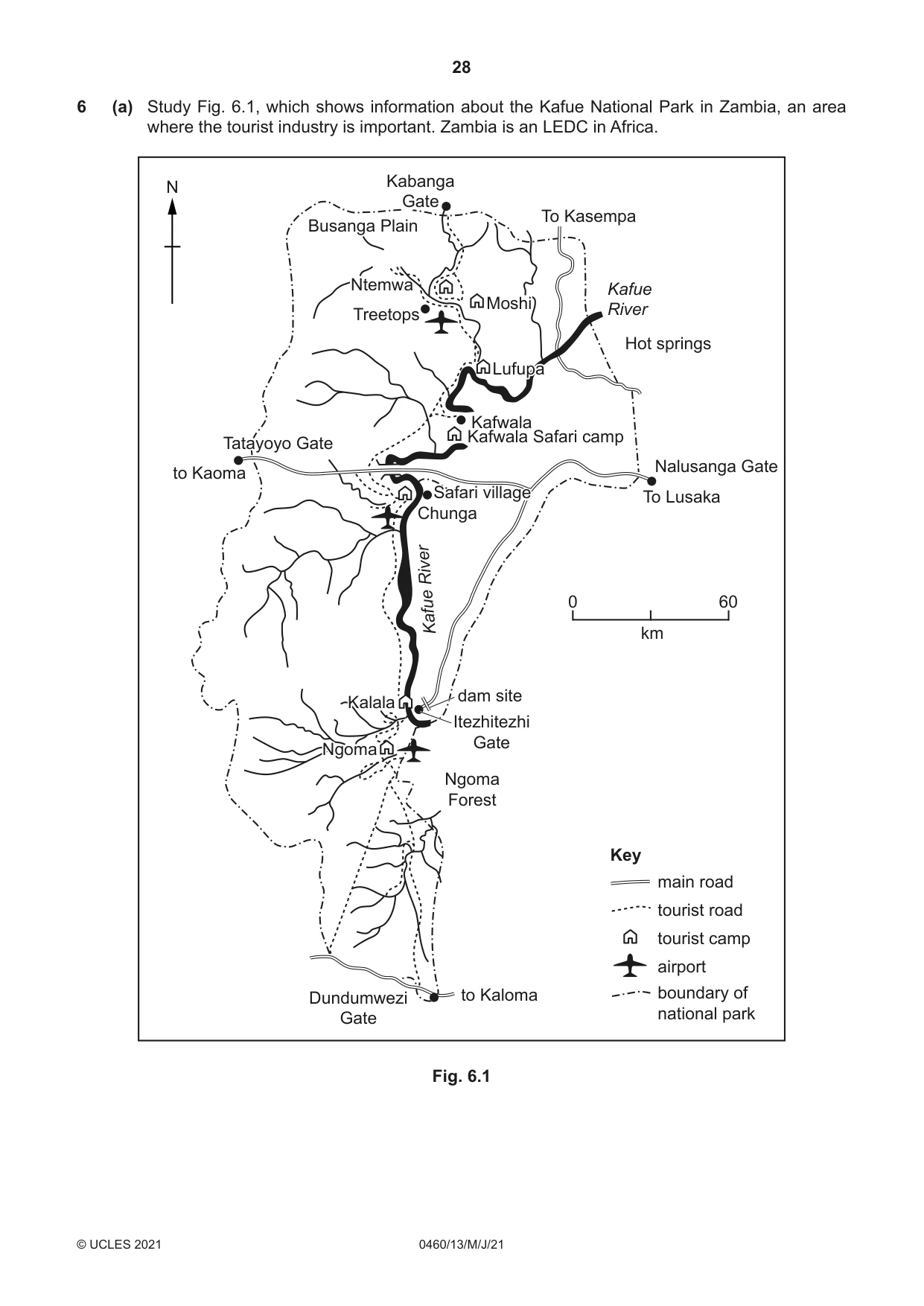
28 0460/13/M/J/21 © UCLES 2021 6 (a) Study Fig. 6.1, which shows information about the Kafue National Park in Zambia, an area where the tourist industry is important. Zambia is an LEDC in Africa. N 0 Key main road tourist road tourist camp airport boundary of national park 60 km to Kaoma to Lusaka to Kasempa to Kaloma hot springs Kabanga gate Nalusanga gate Tatayoyo gate Lufupa Moshi Kafue river Kafwala Kafwala safari camp Busanga plain Treetops Ntemwa Dundumwenze gate Itezhitezhi gate dam site Kalala Ngoma forest Ngoma Safari village Chunga Kafue river to Kaoma To Lusaka To Kasempa to Kaloma Hot springs Kabanga Gate Nalusanga Gate Tatayoyo Gate Lufupa Moshi Kafue River Kafwala Kafwala Safari camp Busanga Plain Treetops Ntemwa Dundumwezi Gate Itezhitezhi Gate dam site Kalala Ngoma Forest Ngoma Safari village Chunga Kafue River Fig. 6.1
Question paper, page 29
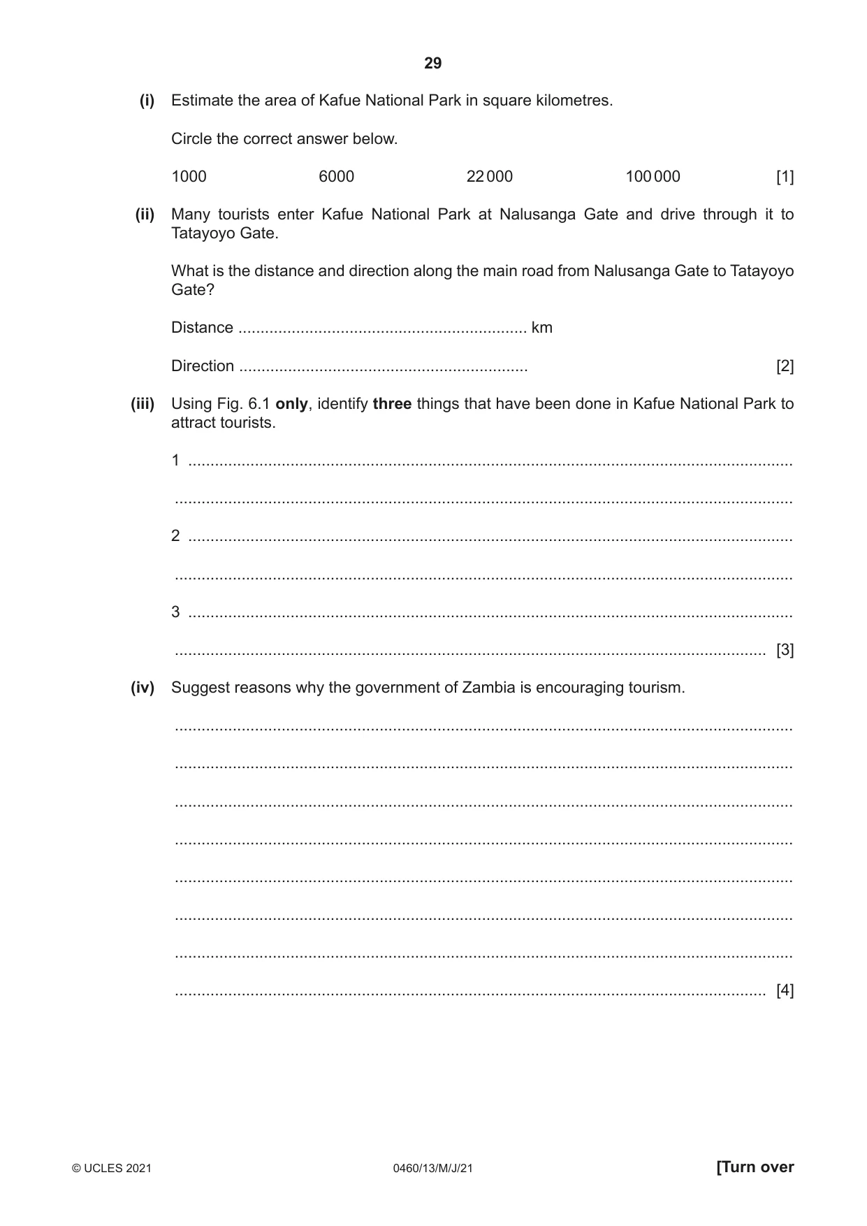
29 0460/13/M/J/21 © UCLES 2021 [Turn over (i) Estimate the area of Kafue National Park in square kilometres. Circle the correct answer below. 1000 6000 22 000 100 000 [1] (ii) Many tourists enter Kafue National Park at Nalusanga Gate and drive through it to Tatayoyo Gate. What is the distance and direction along the main road from Nalusanga Gate to Tatayoyo Gate? Distance … km Direction … [2] (iii) Using Fig. 6.1 only, identify three things that have been done in Kafue National Park to attract tourists. 1 … … 2 … … 3 … … [3] (iv) Suggest reasons why the government of Zambia is encouraging tourism. … … … … … … … … [4]
Question paper, page 30
30 0460/13/M/J/21 © UCLES 2021 (b) Study Figs. 6.2 and 6.3 (Insert), which are photographs taken in national parks. Fig. 6.2 was taken in the Lake District National Park in the UK. Fig. 6.3 was taken in the Matopos National Park in Zimbabwe. (i) Describe the natural attractions of the Lake District and Matopos National Parks which are shown in Figs. 6.2 and 6.3. Fig. 6.2 … … … Fig. 6.3 … … … [3] (ii) Explain how national parks, such as those in Figs. 6.2 and 6.3, manage tourism. … … … … … … … … … … [5]
Question paper, page 31
31 0460/13/M/J/21 © UCLES 2021 (c) For a named tourist area you have studied, explain how the tourist industry may cause problems for local people. Name of tourist area … … … … … … … … … … … … … … … … … … … … … … … … … … [7] [Total: 25]
Question paper, page 32
32 0460/13/M/J/21 © UCLES 2021 Additional Pages If you use the following lined pages to complete the answer(s) to any question(s), the question number(s) must be clearly shown. … … … … … … … … … … … … … … … … … … … … … … … … … …
Question paper, page 33
33 0460/13/M/J/21 © UCLES 2021 … … … … … … … … … … … … … … … … … … … … … … … … … … … …
Question paper, page 34
34 0460/13/M/J/21 © UCLES 2021 BLANK PAGE
Question paper, page 35
35 0460/13/M/J/21 © UCLES 2021 BLANK PAGE
Question paper, page 36
36 0460/13/M/J/21 © UCLES 2021 The boundaries and names shown, the designations used and the presentation of material on any maps contained in this question paper/insert do not imply official endorsement or acceptance by Cambridge Assessment International Education concerning the legal status of any country, territory, or area or any of its authorities, or of the delimitation of its frontiers or boundaries. Permission to reproduce items where third-party owned material protected by copyright is included has been sought and cleared where possible. Every reasonable effort has been made by the publisher (UCLES) to trace copyright holders, but if any items requiring clearance have unwittingly been included, the publisher will be pleased to make amends at the earliest possible opportunity. To avoid the issue of disclosure of answer-related information to candidates, all copyright acknowledgements are reproduced online in the Cambridge Assessment International Education Copyright Acknowledgements Booklet. This is produced for each series of examinations and is freely available to download at www.cambridgeinternational.org after the live examination series. Cambridge Assessment International Education is part of the Cambridge Assessment Group. Cambridge Assessment is the brand name of the University of Cambridge Local Examinations Syndicate (UCLES), which itself is a department of the University of Cambridge. BLANK PAGE
Mark scheme, page 1
This document consists of 21 printed pages. © UCLES 2021 [Turn over Cambridge IGCSE™ GEOGRAPHY 0460/13 Paper 1 May/June 2021 MARK SCHEME Maximum Mark: 75 Published This mark scheme is published as an aid to teachers and candidates, to indicate the requirements of the examination. It shows the basis on which Examiners were instructed to award marks. It does not indicate the details of the discussions that took place at an Examiners’ meeting before marking began, which would have considered the acceptability of alternative answers. Mark schemes should be read in conjunction with the question paper and the Principal Examiner Report for Teachers. Cambridge International will not enter into discussions about these mark schemes. Cambridge International is publishing the mark schemes for the May/June 2021 series for most Cambridge IGCSE™, Cambridge International A and AS Level components and some Cambridge O Level components.
Mark scheme, page 2
0460/13 Cambridge IGCSE – Mark Scheme PUBLISHED May/June 2021 © UCLES 2021 Page 2 of 21 Generic Marking Principles These general marking principles must be applied by all examiners when marking candidate answers. They should be applied alongside the specific content of the mark scheme or generic level descriptors for a question. Each question paper and mark scheme will also comply with these marking principles. GENERIC MARKING PRINCIPLE 1: Marks must be awarded in line with: • the specific content of the mark scheme or the generic level descriptors for the question • the specific skills defined in the mark scheme or in the generic level descriptors for the question • the standard of response required by a candidate as exemplified by the standardisation scripts. GENERIC MARKING PRINCIPLE 2: Marks awarded are always whole marks (not half marks, or other fractions). GENERIC MARKING PRINCIPLE 3: Marks must be awarded positively: • marks are awarded for correct/valid answers, as defined in the mark scheme. However, credit is given for valid answers which go beyond the scope of the syllabus and mark scheme, referring to your Team Leader as appropriate • marks are awarded when candidates clearly demonstrate what they know and can do • marks are not deducted for errors • marks are not deducted for omissions • answers should only be judged on the quality of spelling, punctuation and grammar when these features are specifically assessed by the question as indicated by the mark scheme. The meaning, however, should be unambiguous. GENERIC MARKING PRINCIPLE 4: Rules must be applied consistently, e.g. in situations where candidates have not followed instructions or in the application of generic level descriptors. GENERIC MARKING PRINCIPLE 5: Marks should be awarded using the full range of marks defined in the mark scheme for the question (however; the use of the full mark range may be limited according to the quality of the candidate responses seen). GENERIC MARKING PRINCIPLE 6: Marks awarded are based solely on the requirements as defined in the mark scheme. Marks should not be awarded with grade thresholds or grade descriptors in mind.
Mark scheme, page 3
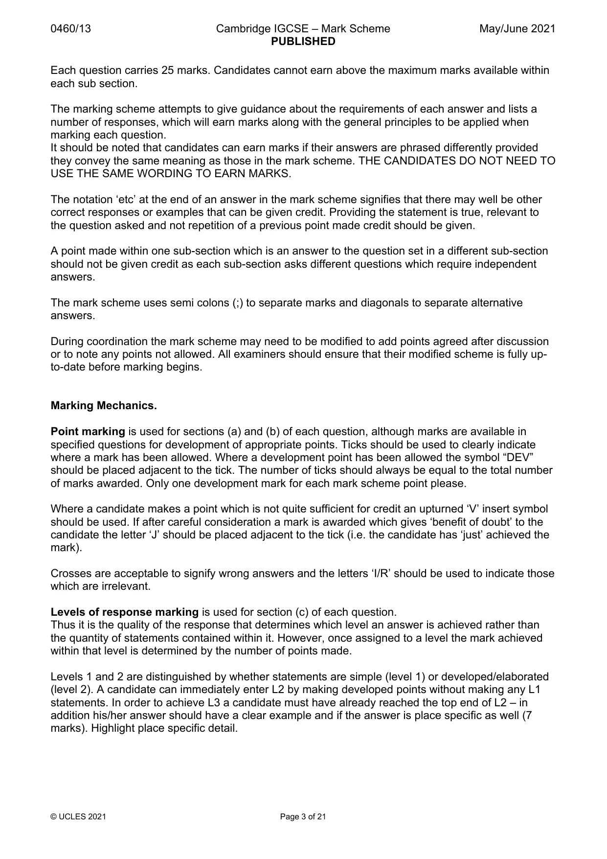
0460/13 Cambridge IGCSE – Mark Scheme PUBLISHED May/June 2021 © UCLES 2021 Page 3 of 21 Each question carries 25 marks. Candidates cannot earn above the maximum marks available within each sub section. The marking scheme attempts to give guidance about the requirements of each answer and lists a number of responses, which will earn marks along with the general principles to be applied when marking each question. It should be noted that candidates can earn marks if their answers are phrased differently provided they convey the same meaning as those in the mark scheme. THE CANDIDATES DO NOT NEED TO USE THE SAME WORDING TO EARN MARKS. The notation ‘etc’ at the end of an answer in the mark scheme signifies that there may well be other correct responses or examples that can be given credit. Providing the statement is true, relevant to the question asked and not repetition of a previous point made credit should be given. A point made within one sub-section which is an answer to the question set in a different sub-section should not be given credit as each sub-section asks different questions which require independent answers. The mark scheme uses semi colons (;) to separate marks and diagonals to separate alternative answers. During coordination the mark scheme may need to be modified to add points agreed after discussion or to note any points not allowed. All examiners should ensure that their modified scheme is fully up- to-date before marking begins. Marking Mechanics. Point marking is used for sections (a) and (b) of each question, although marks are available in specified questions for development of appropriate points. Ticks should be used to clearly indicate where a mark has been allowed. Where a development point has been allowed the symbol “DEV” should be placed adjacent to the tick. The number of ticks should always be equal to the total number of marks awarded. Only one development mark for each mark scheme point please. Where a candidate makes a point which is not quite sufficient for credit an upturned ‘V’ insert symbol should be used. If after careful consideration a mark is awarded which gives ‘benefit of doubt’ to the candidate the letter ‘J’ should be placed adjacent to the tick (i.e. the candidate has ‘just’ achieved the mark). Crosses are acceptable to signify wrong answers and the letters ‘I/R’ should be used to indicate those which are irrelevant. Levels of response marking is used for section (c) of each question. Thus it is the quality of the response that determines which level an answer is achieved rather than the quantity of statements contained within it. However, once assigned to a level the mark achieved within that level is determined by the number of points made. Levels 1 and 2 are distinguished by whether statements are simple (level 1) or developed/elaborated (level 2). A candidate can immediately enter L2 by making developed points without making any L1 statements. In order to achieve L3 a candidate must have already reached the top end of L2 – in addition his/her answer should have a clear example and if the answer is place specific as well (7 marks). Highlight place specific detail.
Mark scheme, page 4
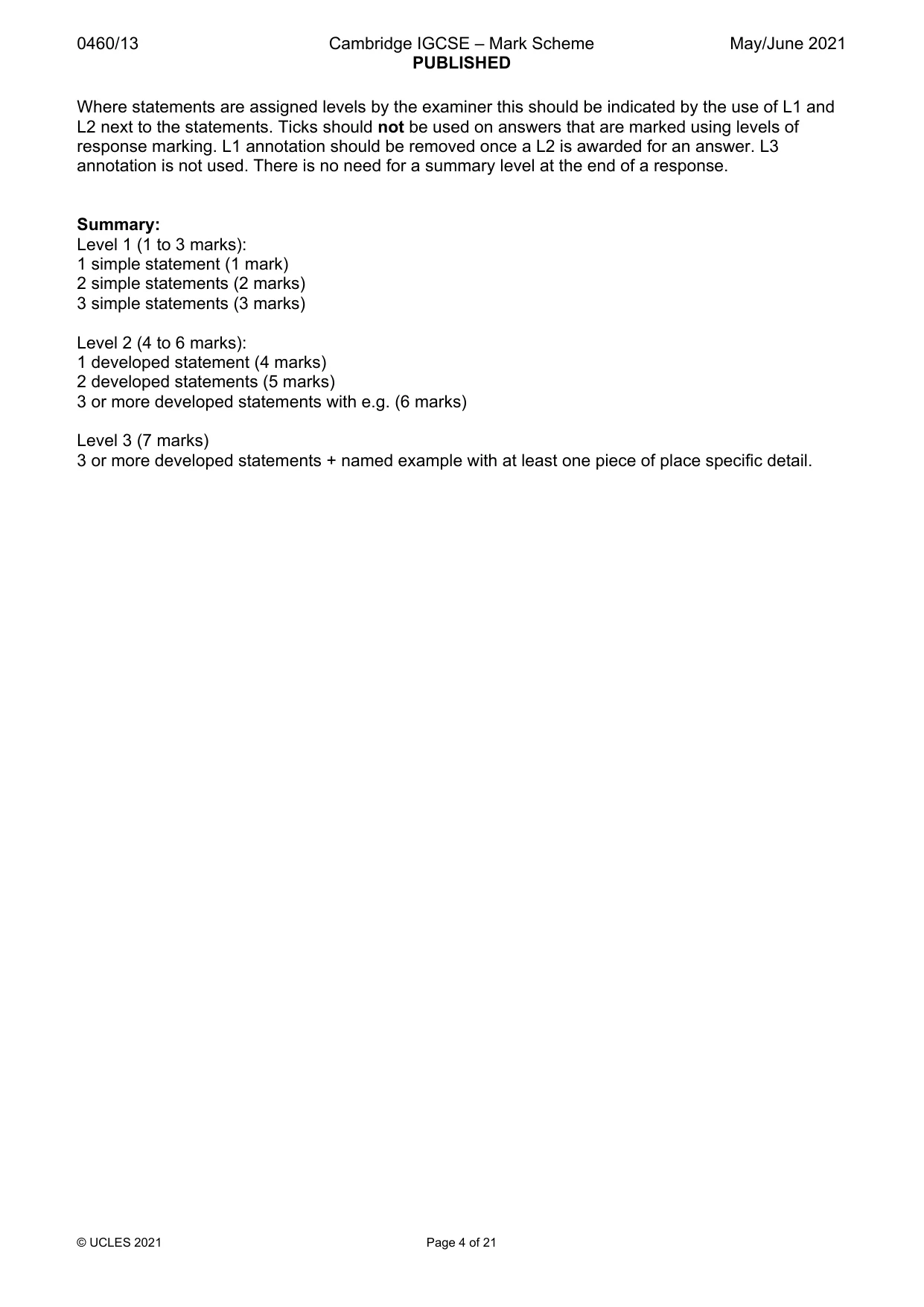
0460/13 Cambridge IGCSE – Mark Scheme PUBLISHED May/June 2021 © UCLES 2021 Page 4 of 21 Where statements are assigned levels by the examiner this should be indicated by the use of L1 and L2 next to the statements. Ticks should not be used on answers that are marked using levels of response marking. L1 annotation should be removed once a L2 is awarded for an answer. L3 annotation is not used. There is no need for a summary level at the end of a response. Summary: Level 1 (1 to 3 marks): 1 simple statement (1 mark) 2 simple statements (2 marks) 3 simple statements (3 marks) Level 2 (4 to 6 marks): 1 developed statement (4 marks) 2 developed statements (5 marks) 3 or more developed statements with e.g. (6 marks) Level 3 (7 marks) 3 or more developed statements + named example with at least one piece of place specific detail.
Mark scheme, page 5
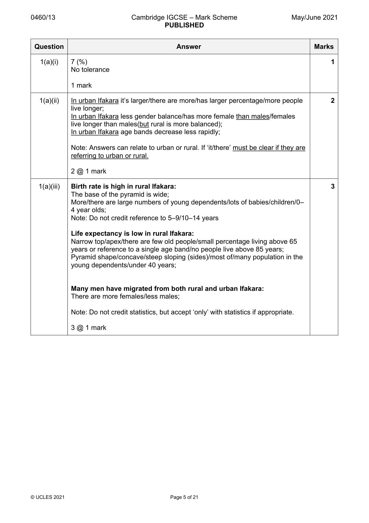
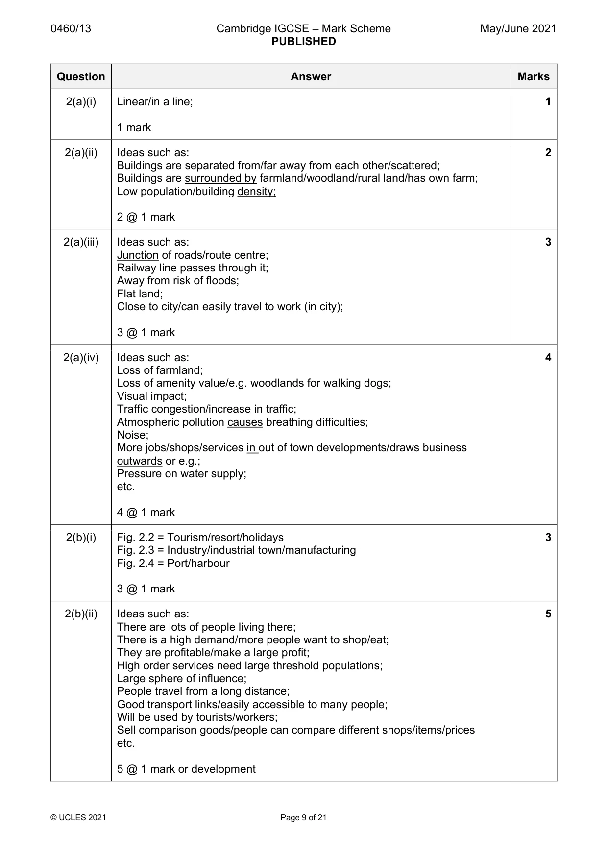
0460/13 Cambridge IGCSE – Mark Scheme PUBLISHED May/June 2021 © UCLES 2021 Page 5 of 21 Question Answer Marks 1(a)(i) 7 (%) No tolerance 1 mark 1 1(a)(ii) In urban Ifakara it’s larger/there are more/has larger percentage/more people live longer; In urban Ifakara less gender balance/has more female than males/females live longer than males(but rural is more balanced); In urban Ifakara age bands decrease less rapidly; Note: Answers can relate to urban or rural. If ‘it/there’ must be clear if they are referring to urban or rural. 2 @ 1 mark 2 1(a)(iii) Birth rate is high in rural Ifakara: The base of the pyramid is wide; More/there are large numbers of young dependents/lots of babies/children/0– 4 year olds; Note: Do not credit reference to 5–9/10–14 years Life expectancy is low in rural Ifakara: Narrow top/apex/there are few old people/small percentage living above 65 years or reference to a single age band/no people live above 85 years; Pyramid shape/concave/steep sloping (sides)/most of/many population in the young dependents/under 40 years; Many men have migrated from both rural and urban Ifakara: There are more females/less males; Note: Do not credit statistics, but accept ‘only’ with statistics if appropriate. 3 @ 1 mark 3
Mark scheme, page 6
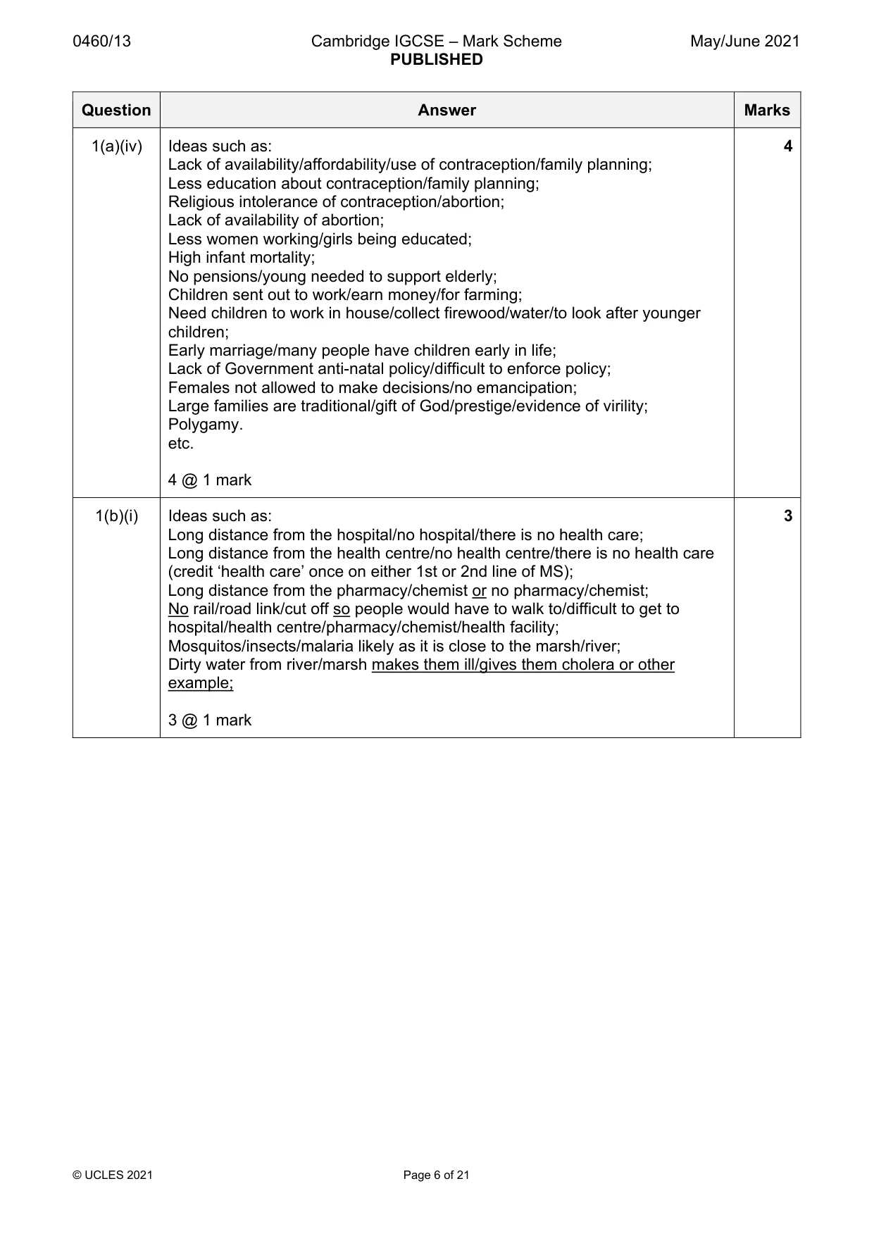
0460/13 Cambridge IGCSE – Mark Scheme PUBLISHED May/June 2021 © UCLES 2021 Page 6 of 21 Question Answer Marks 1(a)(iv) Ideas such as: Lack of availability/affordability/use of contraception/family planning; Less education about contraception/family planning; Religious intolerance of contraception/abortion; Lack of availability of abortion; Less women working/girls being educated; High infant mortality; No pensions/young needed to support elderly; Children sent out to work/earn money/for farming; Need children to work in house/collect firewood/water/to look after younger children; Early marriage/many people have children early in life; Lack of Government anti-natal policy/difficult to enforce policy; Females not allowed to make decisions/no emancipation; Large families are traditional/gift of God/prestige/evidence of virility; Polygamy. etc. 4 @ 1 mark 4 1(b)(i) Ideas such as: Long distance from the hospital/no hospital/there is no health care; Long distance from the health centre/no health centre/there is no health care (credit ‘health care’ once on either 1st or 2nd line of MS); Long distance from the pharmacy/chemist or no pharmacy/chemist; No rail/road link/cut off so people would have to walk to/difficult to get to hospital/health centre/pharmacy/chemist/health facility; Mosquitos/insects/malaria likely as it is close to the marsh/river; Dirty water from river/marsh makes them ill/gives them cholera or other example; 3 @ 1 mark 3
Mark scheme, page 7
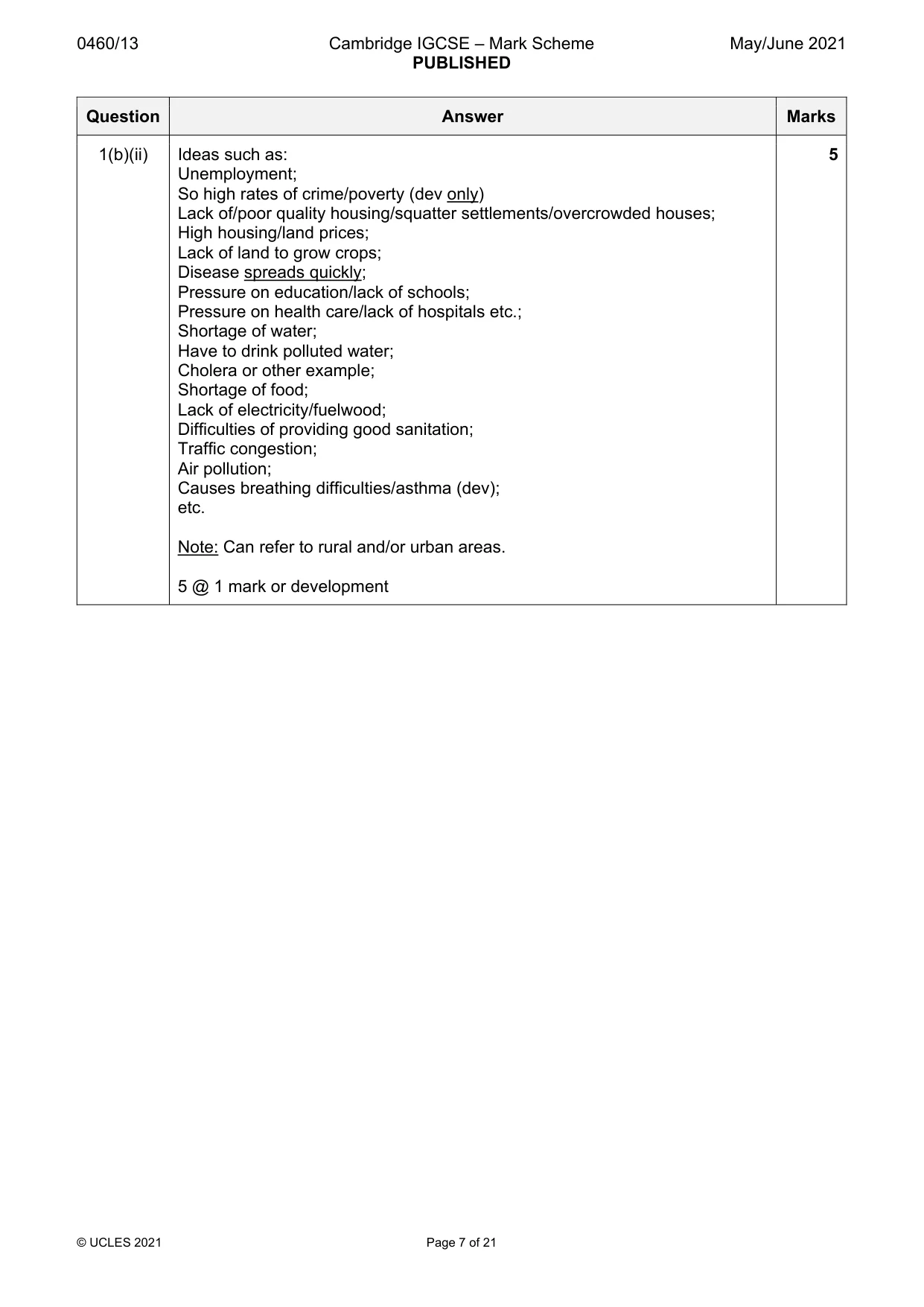
0460/13 Cambridge IGCSE – Mark Scheme PUBLISHED May/June 2021 © UCLES 2021 Page 7 of 21 Question Answer Marks 1(b)(ii) Ideas such as: Unemployment; So high rates of crime/poverty (dev only) Lack of/poor quality housing/squatter settlements/overcrowded houses; High housing/land prices; Lack of land to grow crops; Disease spreads quickly; Pressure on education/lack of schools; Pressure on health care/lack of hospitals etc.; Shortage of water; Have to drink polluted water; Cholera or other example; Shortage of food; Lack of electricity/fuelwood; Difficulties of providing good sanitation; Traffic congestion; Air pollution; Causes breathing difficulties/asthma (dev); etc. Note: Can refer to rural and/or urban areas. 5 @ 1 mark or development 5
Mark scheme, page 8
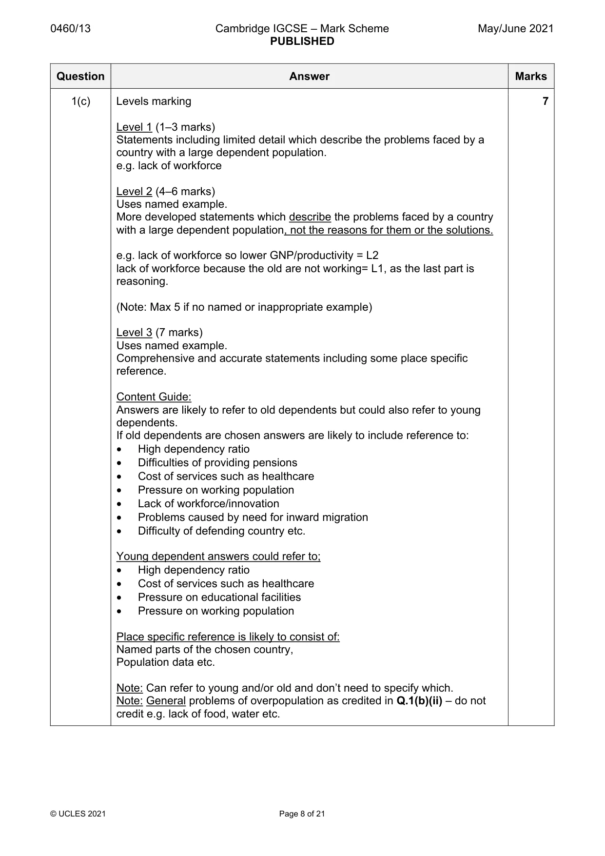
0460/13 Cambridge IGCSE – Mark Scheme PUBLISHED May/June 2021 © UCLES 2021 Page 8 of 21 Question Answer Marks 1(c) Levels marking Level 1 (1–3 marks) Statements including limited detail which describe the problems faced by a country with a large dependent population. e.g. lack of workforce Level 2 (4–6 marks) Uses named example. More developed statements which describe the problems faced by a country with a large dependent population, not the reasons for them or the solutions. e.g. lack of workforce so lower GNP/productivity = L2 lack of workforce because the old are not working= L1, as the last part is reasoning. (Note: Max 5 if no named or inappropriate example) Level 3 (7 marks) Uses named example. Comprehensive and accurate statements including some place specific reference. Content Guide: Answers are likely to refer to old dependents but could also refer to young dependents. If old dependents are chosen answers are likely to include reference to: • High dependency ratio • Difficulties of providing pensions • Cost of services such as healthcare • Pressure on working population • Lack of workforce/innovation • Problems caused by need for inward migration • Difficulty of defending country etc. Young dependent answers could refer to; • High dependency ratio • Cost of services such as healthcare • Pressure on educational facilities • Pressure on working population Place specific reference is likely to consist of: Named parts of the chosen country, Population data etc. Note: Can refer to young and/or old and don’t need to specify which. Note: General problems of overpopulation as credited in Q.1(b)(ii) – do not credit e.g. lack of food, water etc. 7
Mark scheme, page 9
0460/13 Cambridge IGCSE – Mark Scheme PUBLISHED May/June 2021 © UCLES 2021 Page 9 of 21 Question Answer Marks 2(a)(i) Linear/in a line; 1 mark 1 2(a)(ii) Ideas such as: Buildings are separated from/far away from each other/scattered; Buildings are surrounded by farmland/woodland/rural land/has own farm; Low population/building density; 2 @ 1 mark 2 2(a)(iii) Ideas such as: Junction of roads/route centre; Railway line passes through it; Away from risk of floods; Flat land; Close to city/can easily travel to work (in city); 3 @ 1 mark 3 2(a)(iv) Ideas such as: Loss of farmland; Loss of amenity value/e.g. woodlands for walking dogs; Visual impact; Traffic congestion/increase in traffic; Atmospheric pollution causes breathing difficulties; Noise; More jobs/shops/services in out of town developments/draws business outwards or e.g.; Pressure on water supply; etc. 4 @ 1 mark 4 2(b)(i) Fig. 2.2 = Tourism/resort/holidays Fig. 2.3 = Industry/industrial town/manufacturing Fig. 2.4 = Port/harbour 3 @ 1 mark 3 2(b)(ii) Ideas such as: There are lots of people living there; There is a high demand/more people want to shop/eat; They are profitable/make a large profit; High order services need large threshold populations; Large sphere of influence; People travel from a long distance; Good transport links/easily accessible to many people; Will be used by tourists/workers; Sell comparison goods/people can compare different shops/items/prices etc. 5 @ 1 mark or development 5
Mark scheme, page 10
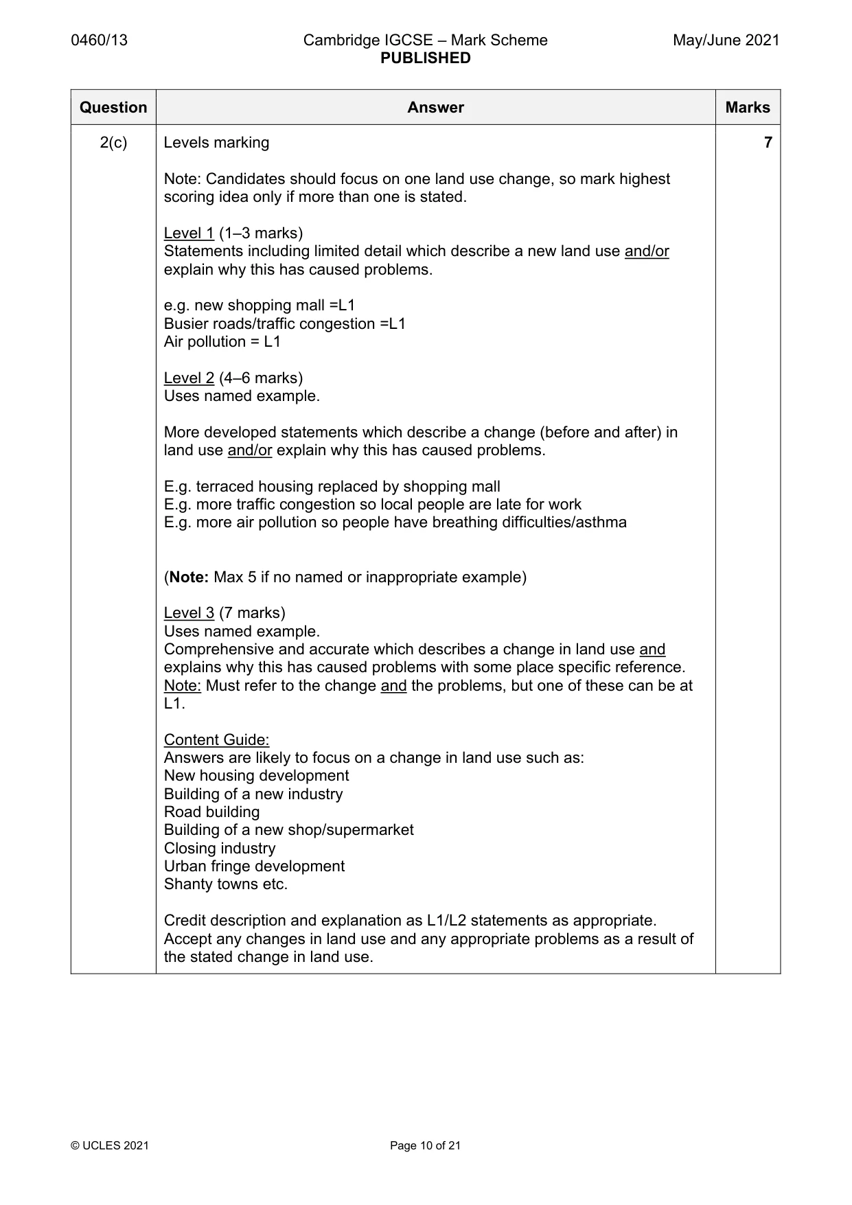
0460/13 Cambridge IGCSE – Mark Scheme PUBLISHED May/June 2021 © UCLES 2021 Page 10 of 21 Question Answer Marks 2(c) Levels marking Note: Candidates should focus on one land use change, so mark highest scoring idea only if more than one is stated. Level 1 (1–3 marks) Statements including limited detail which describe a new land use and/or explain why this has caused problems. e.g. new shopping mall =L1 Busier roads/traffic congestion =L1 Air pollution = L1 Level 2 (4–6 marks) Uses named example. More developed statements which describe a change (before and after) in land use and/or explain why this has caused problems. E.g. terraced housing replaced by shopping mall E.g. more traffic congestion so local people are late for work E.g. more air pollution so people have breathing difficulties/asthma (Note: Max 5 if no named or inappropriate example) Level 3 (7 marks) Uses named example. Comprehensive and accurate which describes a change in land use and explains why this has caused problems with some place specific reference. Note: Must refer to the change and the problems, but one of these can be at L1. Content Guide: Answers are likely to focus on a change in land use such as: New housing development Building of a new industry Road building Building of a new shop/supermarket Closing industry Urban fringe development Shanty towns etc. Credit description and explanation as L1/L2 statements as appropriate. Accept any changes in land use and any appropriate problems as a result of the stated change in land use. 7
Mark scheme, page 11
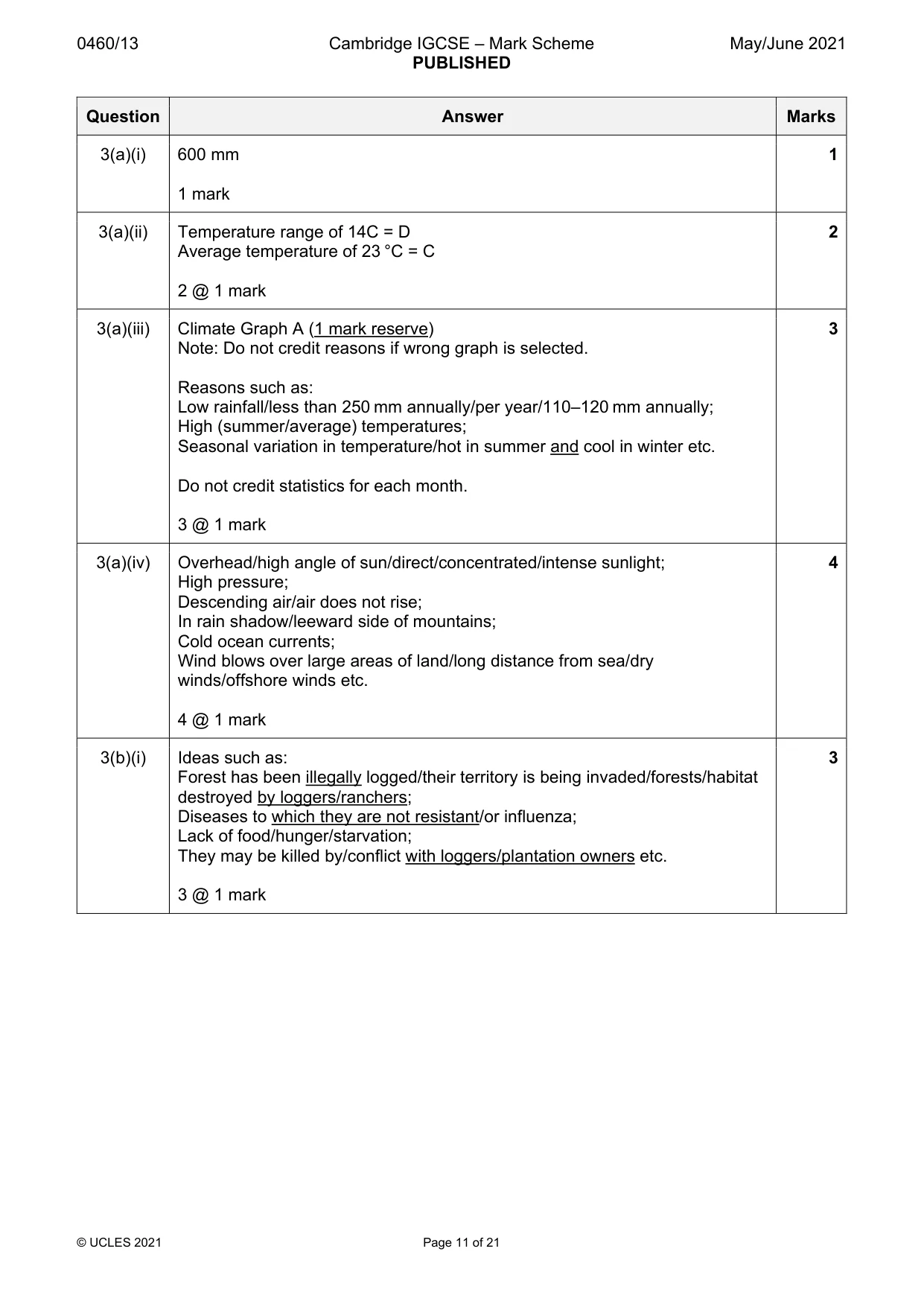
0460/13 Cambridge IGCSE – Mark Scheme PUBLISHED May/June 2021 © UCLES 2021 Page 11 of 21 Question Answer Marks 3(a)(i) 600 mm 1 mark 1 3(a)(ii) Temperature range of 14C = D Average temperature of 23 °C = C 2 @ 1 mark 2 3(a)(iii) Climate Graph A (1 mark reserve) Note: Do not credit reasons if wrong graph is selected. Reasons such as: Low rainfall/less than 250 mm annually/per year/110–120 mm annually; High (summer/average) temperatures; Seasonal variation in temperature/hot in summer and cool in winter etc. Do not credit statistics for each month. 3 @ 1 mark 3 3(a)(iv) Overhead/high angle of sun/direct/concentrated/intense sunlight; High pressure; Descending air/air does not rise; In rain shadow/leeward side of mountains; Cold ocean currents; Wind blows over large areas of land/long distance from sea/dry winds/offshore winds etc. 4 @ 1 mark 4 3(b)(i) Ideas such as: Forest has been illegally logged/their territory is being invaded/forests/habitat destroyed by loggers/ranchers; Diseases to which they are not resistant/or influenza; Lack of food/hunger/starvation; They may be killed by/conflict with loggers/plantation owners etc. 3 @ 1 mark 3
Mark scheme, page 12
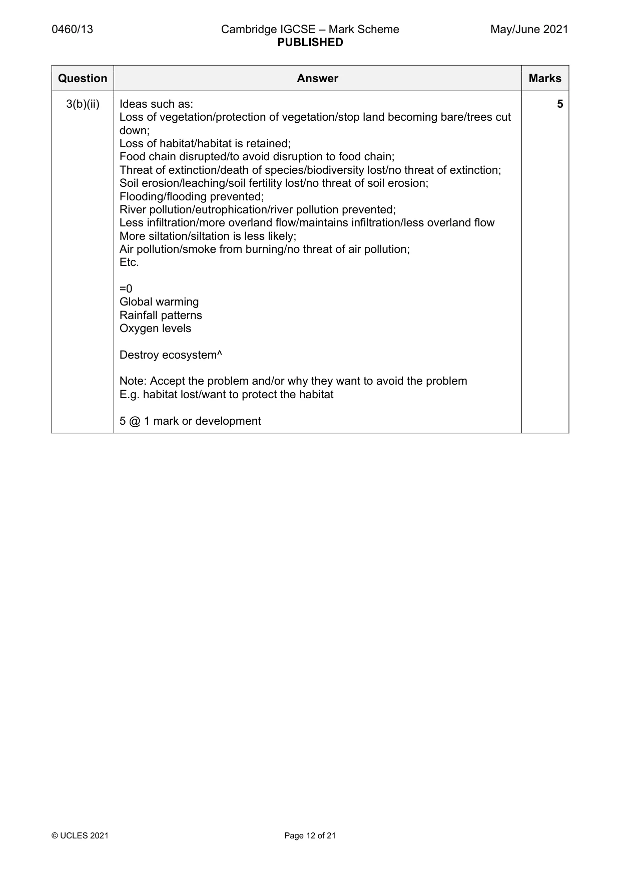
0460/13 Cambridge IGCSE – Mark Scheme PUBLISHED May/June 2021 © UCLES 2021 Page 12 of 21 Question Answer Marks 3(b)(ii) Ideas such as: Loss of vegetation/protection of vegetation/stop land becoming bare/trees cut down; Loss of habitat/habitat is retained; Food chain disrupted/to avoid disruption to food chain; Threat of extinction/death of species/biodiversity lost/no threat of extinction; Soil erosion/leaching/soil fertility lost/no threat of soil erosion; Flooding/flooding prevented; River pollution/eutrophication/river pollution prevented; Less infiltration/more overland flow/maintains infiltration/less overland flow More siltation/siltation is less likely; Air pollution/smoke from burning/no threat of air pollution; Etc. =0 Global warming Rainfall patterns Oxygen levels Destroy ecosystem^ Note: Accept the problem and/or why they want to avoid the problem E.g. habitat lost/want to protect the habitat 5 @ 1 mark or development 5
Mark scheme, page 13
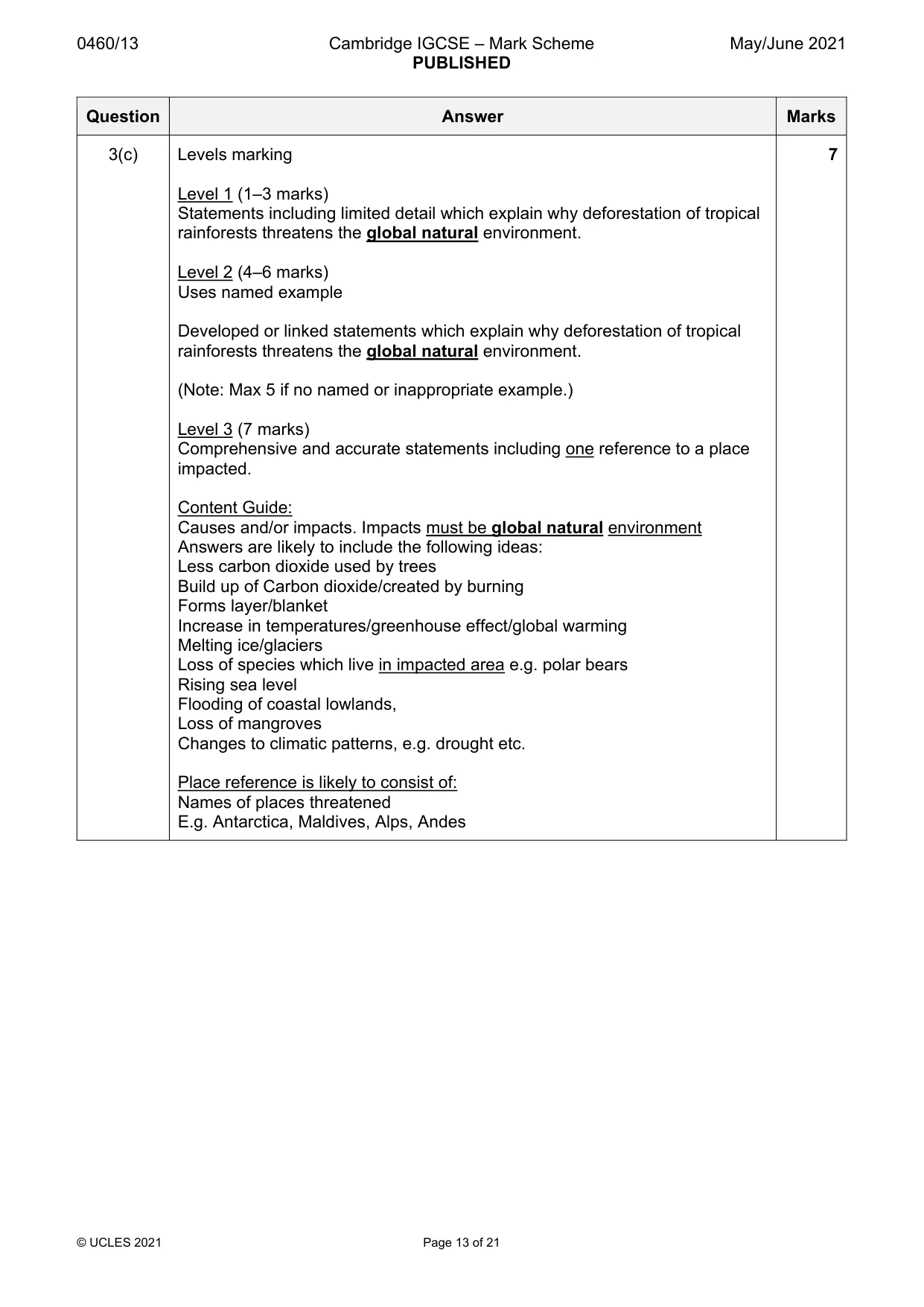
0460/13 Cambridge IGCSE – Mark Scheme PUBLISHED May/June 2021 © UCLES 2021 Page 13 of 21 Question Answer Marks 3(c) Levels marking Level 1 (1–3 marks) Statements including limited detail which explain why deforestation of tropical rainforests threatens the global natural environment. Level 2 (4–6 marks) Uses named example Developed or linked statements which explain why deforestation of tropical rainforests threatens the global natural environment. (Note: Max 5 if no named or inappropriate example.) Level 3 (7 marks) Comprehensive and accurate statements including one reference to a place impacted. Content Guide: Causes and/or impacts. Impacts must be global natural environment Answers are likely to include the following ideas: Less carbon dioxide used by trees Build up of Carbon dioxide/created by burning Forms layer/blanket Increase in temperatures/greenhouse effect/global warming Melting ice/glaciers Loss of species which live in impacted area e.g. polar bears Rising sea level Flooding of coastal lowlands, Loss of mangroves Changes to climatic patterns, e.g. drought etc. Place reference is likely to consist of: Names of places threatened E.g. Antarctica, Maldives, Alps, Andes 7
Mark scheme, page 14
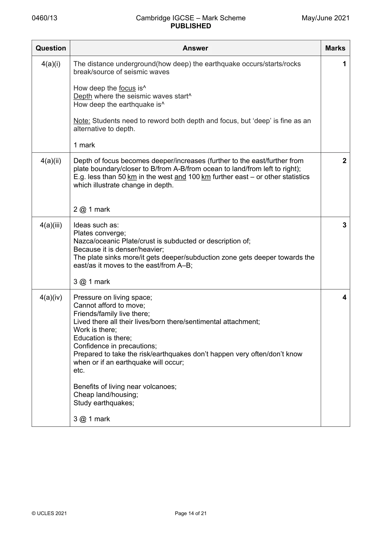
0460/13 Cambridge IGCSE – Mark Scheme PUBLISHED May/June 2021 © UCLES 2021 Page 14 of 21 Question Answer Marks 4(a)(i) The distance underground(how deep) the earthquake occurs/starts/rocks break/source of seismic waves How deep the focus is^ Depth where the seismic waves start^ How deep the earthquake is^ Note: Students need to reword both depth and focus, but ‘deep’ is fine as an alternative to depth. 1 mark 1 4(a)(ii) Depth of focus becomes deeper/increases (further to the east/further from plate boundary/closer to B/from A-B/from ocean to land/from left to right); E.g. less than 50 km in the west and 100 km further east – or other statistics which illustrate change in depth. 2 @ 1 mark 2 4(a)(iii) Ideas such as: Plates converge; Nazca/oceanic Plate/crust is subducted or description of; Because it is denser/heavier; The plate sinks more/it gets deeper/subduction zone gets deeper towards the east/as it moves to the east/from A–B; 3 @ 1 mark 3 4(a)(iv) Pressure on living space; Cannot afford to move; Friends/family live there; Lived there all their lives/born there/sentimental attachment; Work is there; Education is there; Confidence in precautions; Prepared to take the risk/earthquakes don’t happen very often/don’t know when or if an earthquake will occur; etc. Benefits of living near volcanoes; Cheap land/housing; Study earthquakes; 3 @ 1 mark 4
Mark scheme, page 15
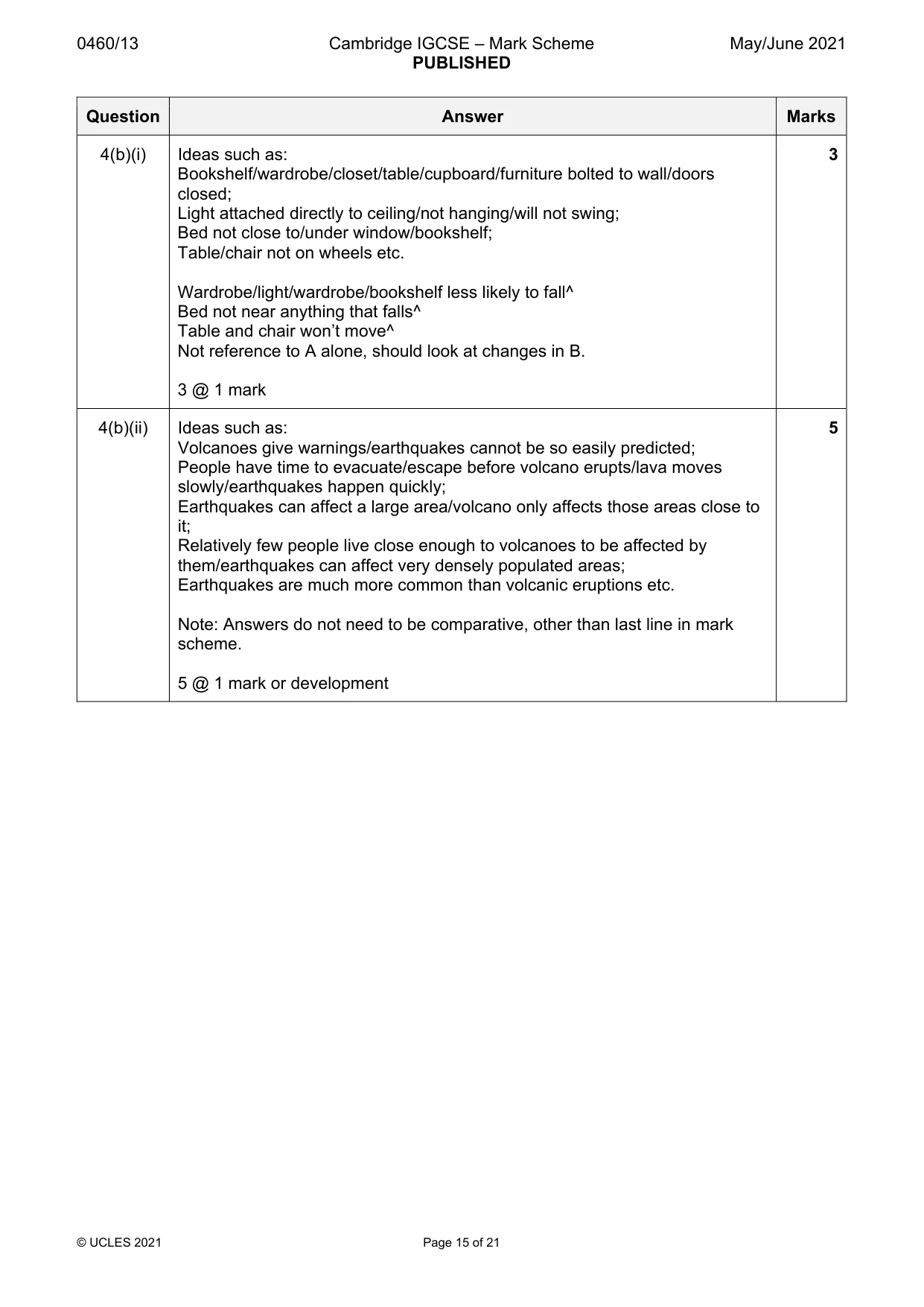
0460/13 Cambridge IGCSE – Mark Scheme PUBLISHED May/June 2021 © UCLES 2021 Page 15 of 21 Question Answer Marks 4(b)(i) Ideas such as: Bookshelf/wardrobe/closet/table/cupboard/furniture bolted to wall/doors closed; Light attached directly to ceiling/not hanging/will not swing; Bed not close to/under window/bookshelf; Table/chair not on wheels etc. Wardrobe/light/wardrobe/bookshelf less likely to fall^ Bed not near anything that falls^ Table and chair won’t move^ Not reference to A alone, should look at changes in B. 3 @ 1 mark 3 4(b)(ii) Ideas such as: Volcanoes give warnings/earthquakes cannot be so easily predicted; People have time to evacuate/escape before volcano erupts/lava moves slowly/earthquakes happen quickly; Earthquakes can affect a large area/volcano only affects those areas close to it; Relatively few people live close enough to volcanoes to be affected by them/earthquakes can affect very densely populated areas; Earthquakes are much more common than volcanic eruptions etc. Note: Answers do not need to be comparative, other than last line in mark scheme. 5 @ 1 mark or development 5
Mark scheme, page 16
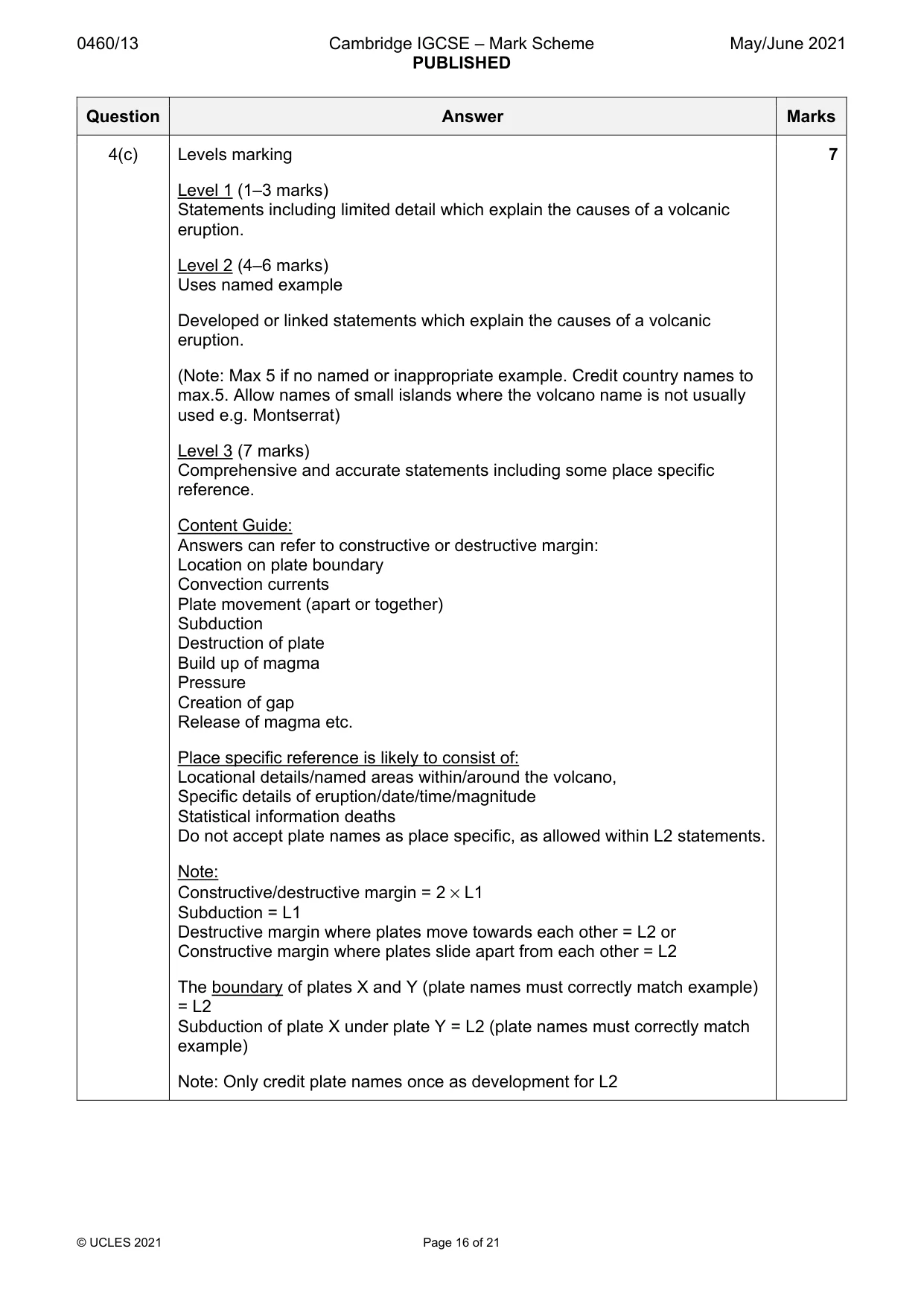
0460/13 Cambridge IGCSE – Mark Scheme PUBLISHED May/June 2021 © UCLES 2021 Page 16 of 21 Question Answer Marks 4(c) Levels marking Level 1 (1–3 marks) Statements including limited detail which explain the causes of a volcanic eruption. Level 2 (4–6 marks) Uses named example Developed or linked statements which explain the causes of a volcanic eruption. (Note: Max 5 if no named or inappropriate example. Credit country names to max.5. Allow names of small islands where the volcano name is not usually used e.g. Montserrat) Level 3 (7 marks) Comprehensive and accurate statements including some place specific reference. Content Guide: Answers can refer to constructive or destructive margin: Location on plate boundary Convection currents Plate movement (apart or together) Subduction Destruction of plate Build up of magma Pressure Creation of gap Release of magma etc. Place specific reference is likely to consist of: Locational details/named areas within/around the volcano, Specific details of eruption/date/time/magnitude Statistical information deaths Do not accept plate names as place specific, as allowed within L2 statements. Note: Constructive/destructive margin = 2 × L1 Subduction = L1 Destructive margin where plates move towards each other = L2 or Constructive margin where plates slide apart from each other = L2 The boundary of plates X and Y (plate names must correctly match example) = L2 Subduction of plate X under plate Y = L2 (plate names must correctly match example) Note: Only credit plate names once as development for L2 7
Mark scheme, page 17
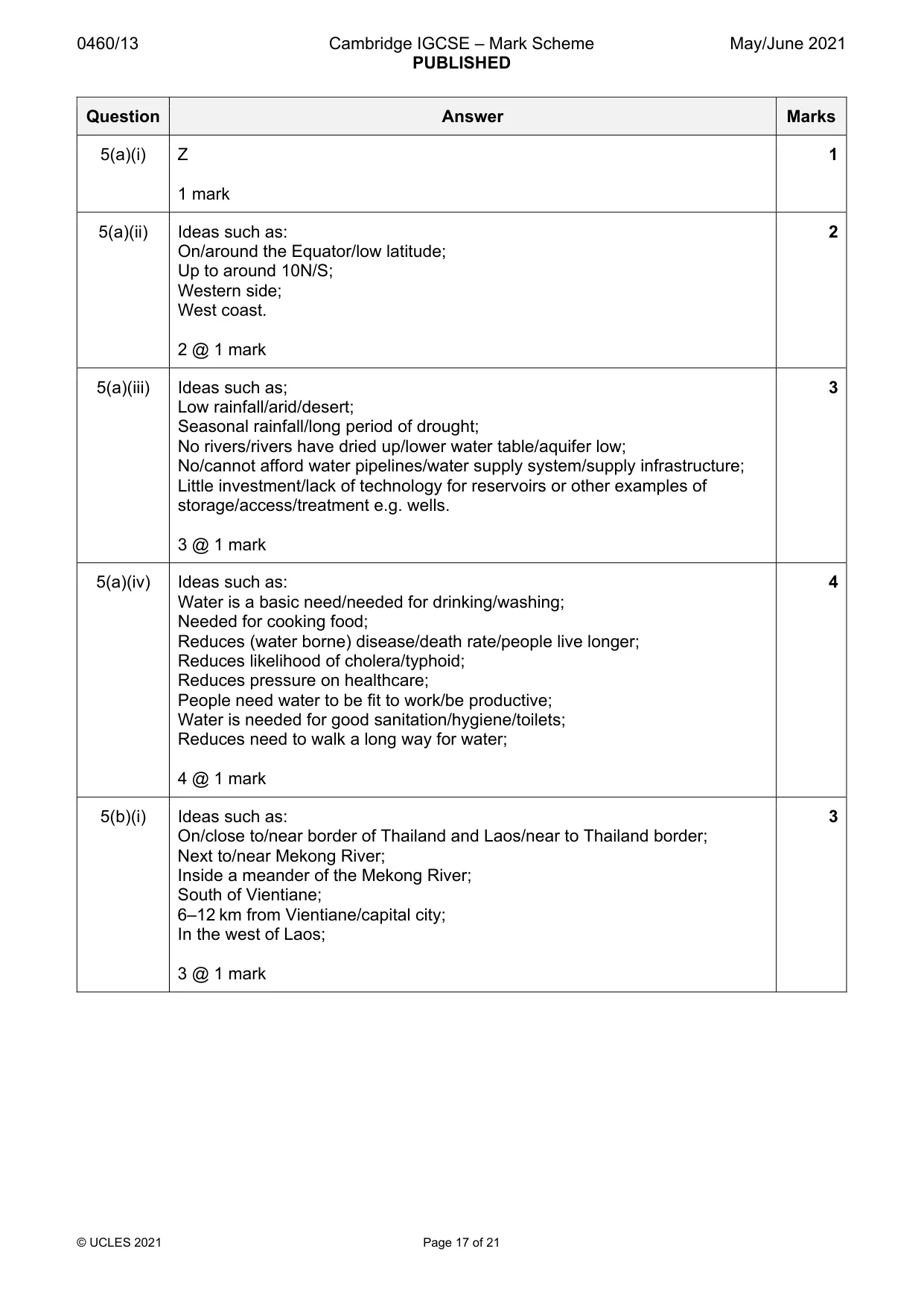
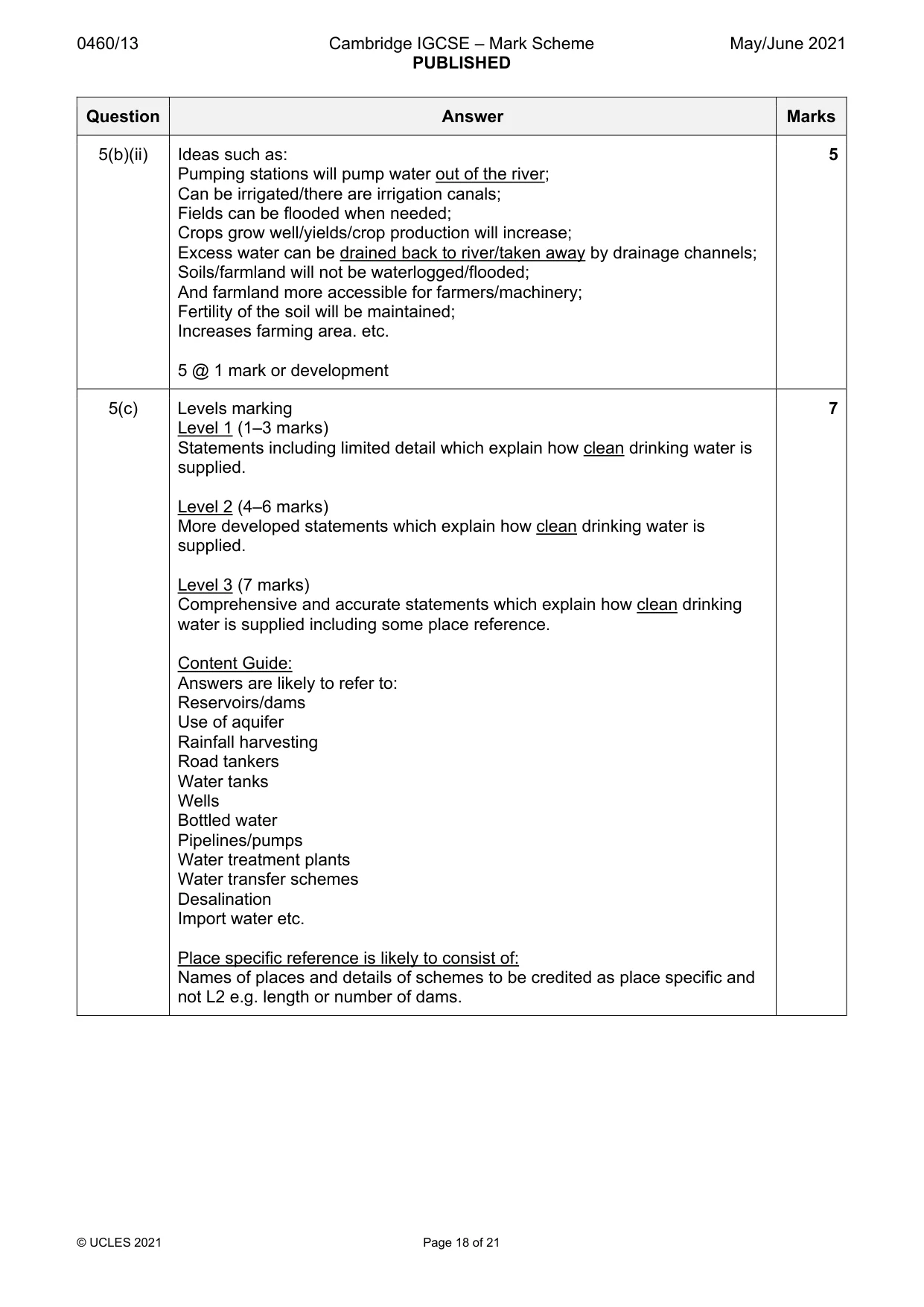
0460/13 Cambridge IGCSE – Mark Scheme PUBLISHED May/June 2021 © UCLES 2021 Page 17 of 21 Question Answer Marks 5(a)(i) Z 1 mark 1 5(a)(ii) Ideas such as: On/around the Equator/low latitude; Up to around 10N/S; Western side; West coast. 2 @ 1 mark 2 5(a)(iii) Ideas such as; Low rainfall/arid/desert; Seasonal rainfall/long period of drought; No rivers/rivers have dried up/lower water table/aquifer low; No/cannot afford water pipelines/water supply system/supply infrastructure; Little investment/lack of technology for reservoirs or other examples of storage/access/treatment e.g. wells. 3 @ 1 mark 3 5(a)(iv) Ideas such as: Water is a basic need/needed for drinking/washing; Needed for cooking food; Reduces (water borne) disease/death rate/people live longer; Reduces likelihood of cholera/typhoid; Reduces pressure on healthcare; People need water to be fit to work/be productive; Water is needed for good sanitation/hygiene/toilets; Reduces need to walk a long way for water; 4 @ 1 mark 4 5(b)(i) Ideas such as: On/close to/near border of Thailand and Laos/near to Thailand border; Next to/near Mekong River; Inside a meander of the Mekong River; South of Vientiane; 6–12 km from Vientiane/capital city; In the west of Laos; 3 @ 1 mark 3
Mark scheme, page 18
0460/13 Cambridge IGCSE – Mark Scheme PUBLISHED May/June 2021 © UCLES 2021 Page 18 of 21 Question Answer Marks 5(b)(ii) Ideas such as: Pumping stations will pump water out of the river; Can be irrigated/there are irrigation canals; Fields can be flooded when needed; Crops grow well/yields/crop production will increase; Excess water can be drained back to river/taken away by drainage channels; Soils/farmland will not be waterlogged/flooded; And farmland more accessible for farmers/machinery; Fertility of the soil will be maintained; Increases farming area. etc. 5 @ 1 mark or development 5 5(c) Levels marking Level 1 (1–3 marks) Statements including limited detail which explain how clean drinking water is supplied. Level 2 (4–6 marks) More developed statements which explain how clean drinking water is supplied. Level 3 (7 marks) Comprehensive and accurate statements which explain how clean drinking water is supplied including some place reference. Content Guide: Answers are likely to refer to: Reservoirs/dams Use of aquifer Rainfall harvesting Road tankers Water tanks Wells Bottled water Pipelines/pumps Water treatment plants Water transfer schemes Desalination Import water etc. Place specific reference is likely to consist of: Names of places and details of schemes to be credited as place specific and not L2 e.g. length or number of dams. 7
Mark scheme, page 19
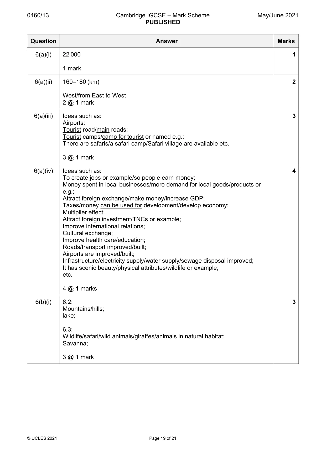
0460/13 Cambridge IGCSE – Mark Scheme PUBLISHED May/June 2021 © UCLES 2021 Page 19 of 21 Question Answer Marks 6(a)(i) 22 000 1 mark 1 6(a)(ii) 160–180 (km) West/from East to West 2 @ 1 mark 2 6(a)(iii) Ideas such as: Airports; Tourist road/main roads; Tourist camps/camp for tourist or named e.g.; There are safaris/a safari camp/Safari village are available etc. 3 @ 1 mark 3 6(a)(iv) Ideas such as: To create jobs or example/so people earn money; Money spent in local businesses/more demand for local goods/products or e.g.; Attract foreign exchange/make money/increase GDP; Taxes/money can be used for development/develop economy; Multiplier effect; Attract foreign investment/TNCs or example; Improve international relations; Cultural exchange; Improve health care/education; Roads/transport improved/built; Airports are improved/built; Infrastructure/electricity supply/water supply/sewage disposal improved; It has scenic beauty/physical attributes/wildlife or example; etc. 4 @ 1 marks 4 6(b)(i) 6.2: Mountains/hills; lake; 6.3: Wildlife/safari/wild animals/giraffes/animals in natural habitat; Savanna; 3 @ 1 mark 3
Mark scheme, page 20
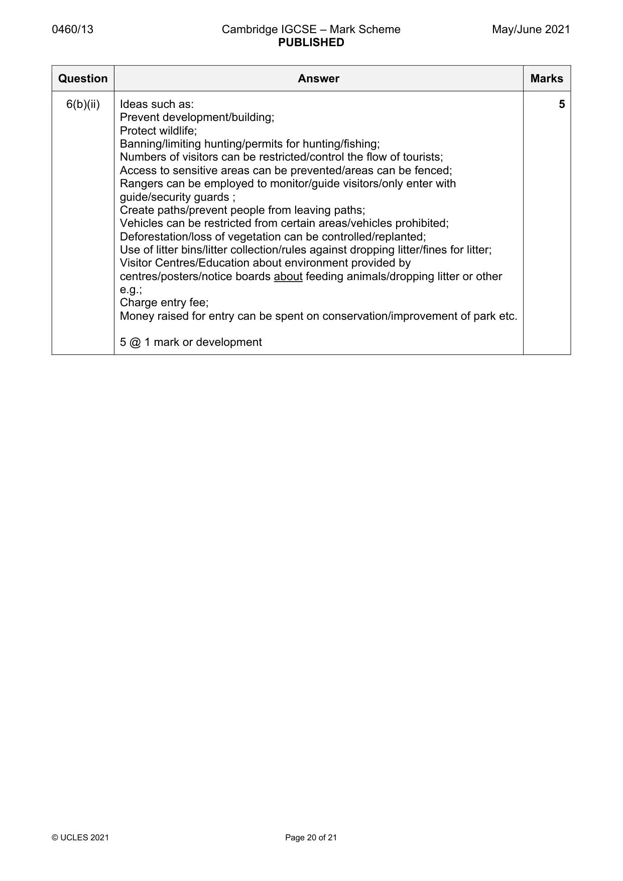
0460/13 Cambridge IGCSE – Mark Scheme PUBLISHED May/June 2021 © UCLES 2021 Page 20 of 21 Question Answer Marks 6(b)(ii) Ideas such as: Prevent development/building; Protect wildlife; Banning/limiting hunting/permits for hunting/fishing; Numbers of visitors can be restricted/control the flow of tourists; Access to sensitive areas can be prevented/areas can be fenced; Rangers can be employed to monitor/guide visitors/only enter with guide/security guards ; Create paths/prevent people from leaving paths; Vehicles can be restricted from certain areas/vehicles prohibited; Deforestation/loss of vegetation can be controlled/replanted; Use of litter bins/litter collection/rules against dropping litter/fines for litter; Visitor Centres/Education about environment provided by centres/posters/notice boards about feeding animals/dropping litter or other e.g.; Charge entry fee; Money raised for entry can be spent on conservation/improvement of park etc. 5 @ 1 mark or development 5
Mark scheme, page 21
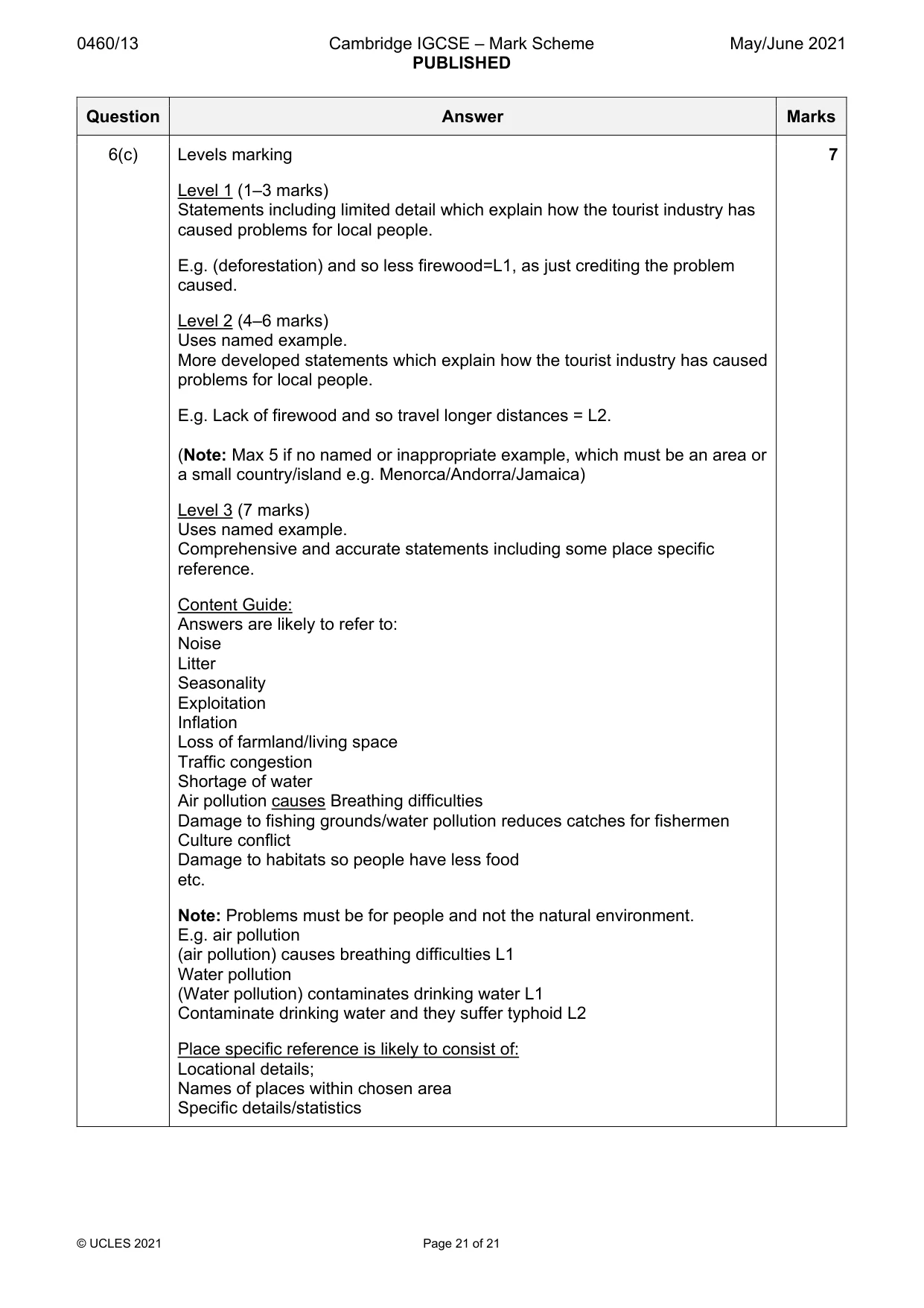
0460/13 Cambridge IGCSE – Mark Scheme PUBLISHED May/June 2021 © UCLES 2021 Page 21 of 21 Question Answer Marks 6(c) Levels marking Level 1 (1–3 marks) Statements including limited detail which explain how the tourist industry has caused problems for local people. E.g. (deforestation) and so less firewood=L1, as just crediting the problem caused. Level 2 (4–6 marks) Uses named example. More developed statements which explain how the tourist industry has caused problems for local people. E.g. Lack of firewood and so travel longer distances = L2. (Note: Max 5 if no named or inappropriate example, which must be an area or a small country/island e.g. Menorca/Andorra/Jamaica) Level 3 (7 marks) Uses named example. Comprehensive and accurate statements including some place specific reference. Content Guide: Answers are likely to refer to: Noise Litter Seasonality Exploitation Inflation Loss of farmland/living space Traffic congestion Shortage of water Air pollution causes Breathing difficulties Damage to fishing grounds/water pollution reduces catches for fishermen Culture conflict Damage to habitats so people have less food etc. Note: Problems must be for people and not the natural environment. E.g. air pollution (air pollution) causes breathing difficulties L1 Water pollution (Water pollution) contaminates drinking water L1 Contaminate drinking water and they suffer typhoid L2 Place specific reference is likely to consist of: Locational details; Names of places within chosen area Specific details/statistics 7
What you needed in this session
Cambridge’s own grade thresholds for 2021 May/June, Paper 1 · Variant 3. A higher threshold means an easier paper — the bar moves with how the cohort did.