Cambridge IGCSE Geography 0460 — 2013 May/June Paper 1 · Variant 2
0460/12/M/J/13 · 75 marks · ≈84 min
The question paper and its mark scheme, free to read here and free to download. This is Cambridge’s own paper, exactly as it was sat.
Question paper28 pages

Mark scheme14 pages
Answers below. Sit the paper first if you are practising.
Paper as text
Question paper, page 1
This document consists of 28 printed pages and 1 Insert. DC (NF/JG) 63681/8 © UCLES 2013 [Turn over UNIVERSITY OF CAMBRIDGE INTERNATIONAL EXAMINATIONS International General Certificate of Secondary Education * 9 2 3 1 1 7 6 8 7 6 * GEOGRAPHY 0460/12 Paper 1 May/June 2013 1 hour 45 minutes Candidates answer on the Question Paper. Additional Materials: Ruler Calculator READ THESE INSTRUCTIONS FIRST Write your Centre number, candidate number and name in the spaces provided. Write in dark blue or black pen. You may use a soft pencil for any diagrams, graphs or rough working. Do not use staples, paper clips, highlighters, glue or correction fluid. DO NOT WRITE ON ANY BARCODES. Write your answer to each question in the space provided. If additional space is required, you should use the lined page at the end of this booklet. The question number(s) must be clearly shown. Answer three questions. The Insert contains Photograph A for Question 2, Photograph B for Question 3, Photograph C for Question 4 and Photographs D, E and F for Question 5. The Insert is not required by the Examiner. Sketch maps and diagrams should be drawn whenever they serve to illustrate an answer. At the end of the examination, fasten all your work securely together. The number of marks is given in brackets [ ] at the end of each question or part question. For Examiner’s Use Q1 Q2 Q3 Q4 Q5 Q6 Total www.theallpapers.com
Question paper, page 2
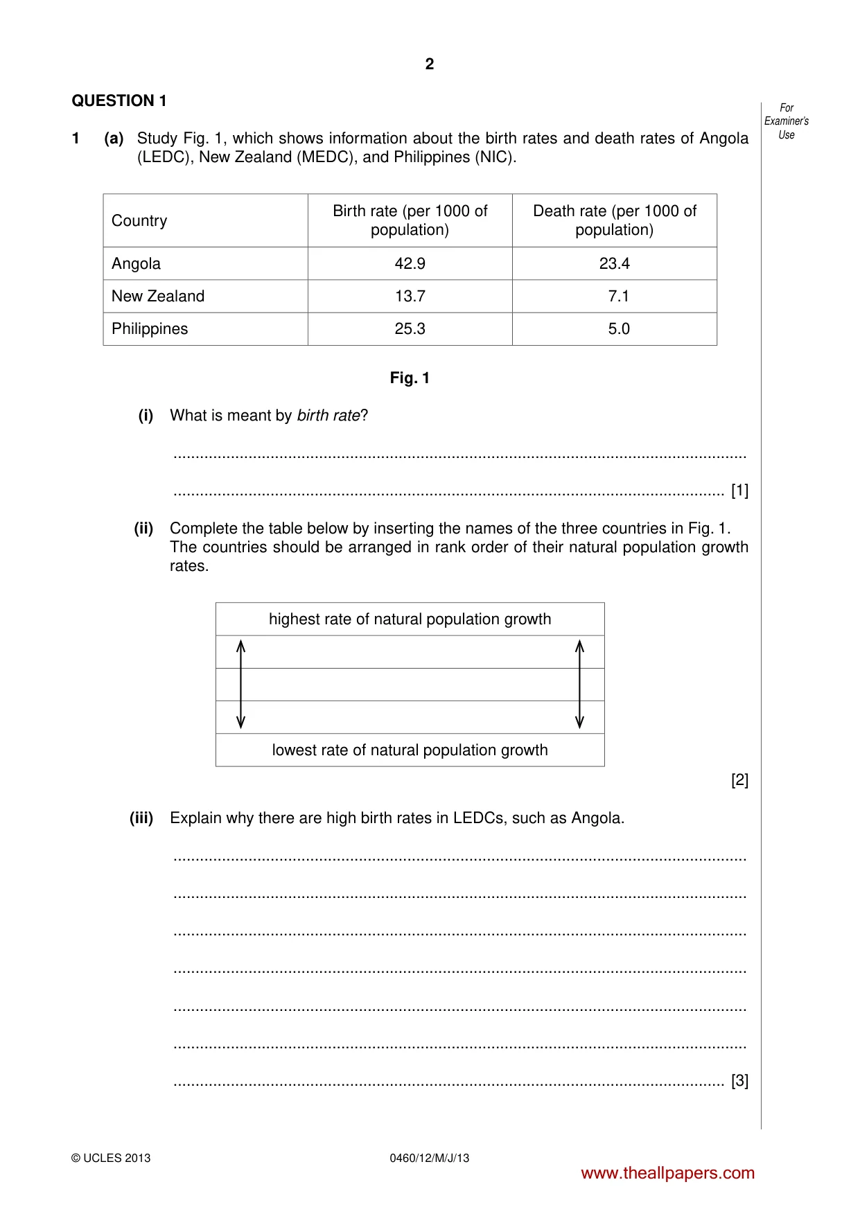
2 0460/12/M/J/13 © UCLES 2013 For Examiner’s Use QUESTION 1 1 (a) Study Fig. 1, which shows information about the birth rates and death rates of Angola (LEDC), New Zealand (MEDC), and Philippines (NIC). Country Birth rate (per 1000 of population) Death rate (per 1000 of population) Angola 42.9 23.4 New Zealand 13.7 7.1 Philippines 25.3 5.0 Fig. 1 (i) What is meant by birth rate? … … [1] (ii) Complete the table below by inserting the names of the three countries in Fig. 1. The countries should be arranged in rank order of their natural population growth rates. highest rate of natural population growth lowest rate of natural population growth [2] (iii) Explain why there are high birth rates in LEDCs, such as Angola. … … … … … … … [3] www.theallpapers.com
Question paper, page 3
3 0460/12/M/J/13 © UCLES 2013 [Turn over For Examiner’s Use (iv) Explain how death rates have been reduced in NICs, such as Philippines. … … … … … … … … [4] www.theallpapers.com
Question paper, page 4
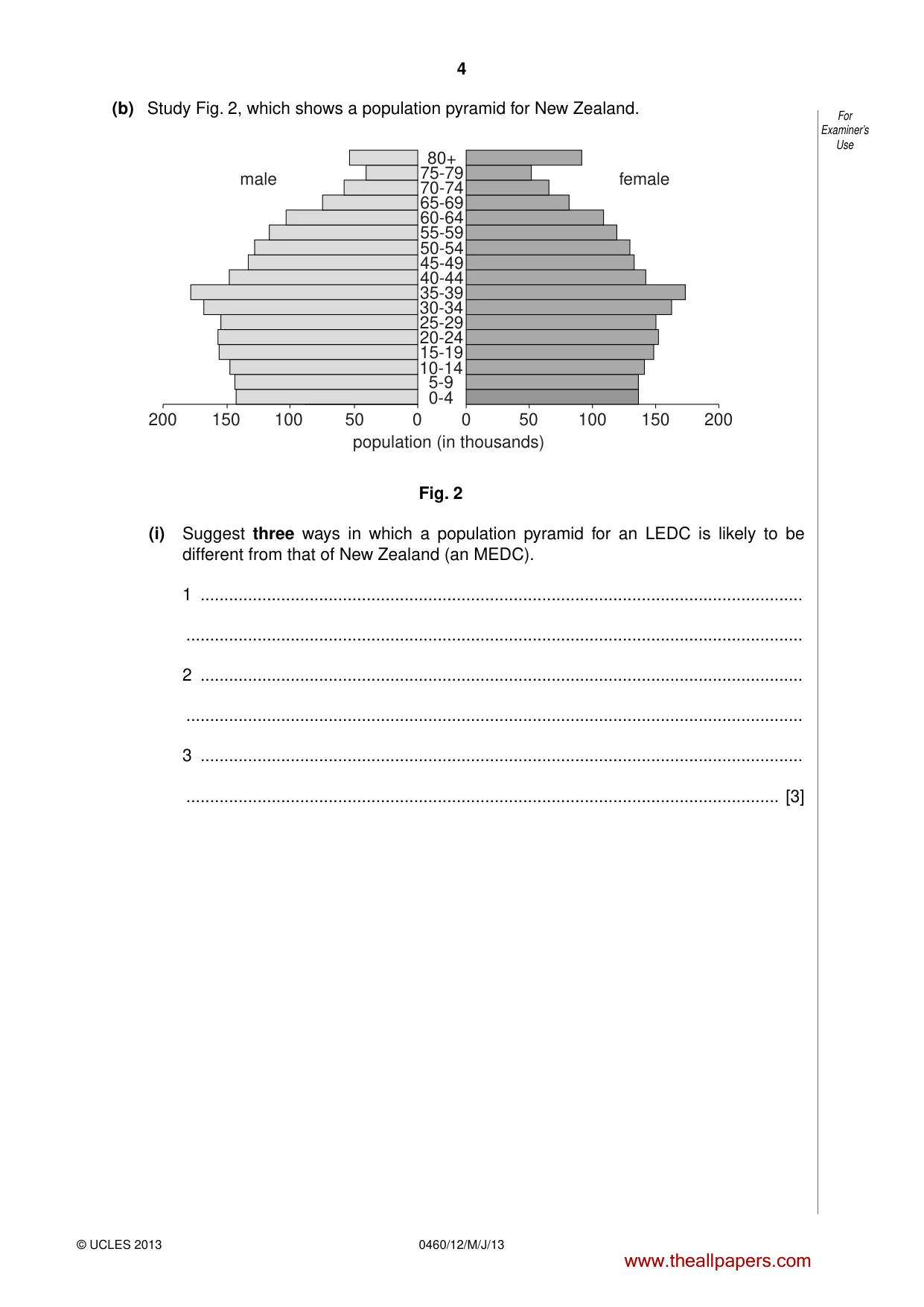
4 0460/12/M/J/13 © UCLES 2013 For Examiner’s Use (b) Study Fig. 2, which shows a population pyramid for New Zealand. male female 200 200 150 100 150 100 50 50 0 0 40-44 45-49 50-54 55-59 60-64 65-69 70-74 75-79 80+ 35-39 30-34 25-29 20-24 15-19 10-14 5-9 0-4 population (in thousands) Fig. 2 (i) Suggest three ways in which a population pyramid for an LEDC is likely to be different from that of New Zealand (an MEDC). 1 … … 2 … … 3 … … [3] www.theallpapers.com
Question paper, page 5
5 0460/12/M/J/13 © UCLES 2013 [Turn over For Examiner’s Use (ii) Describe the likely problems for an MEDC, such as New Zealand, of having so many old dependents. … … … … … … … … … … [5] www.theallpapers.com
Question paper, page 6
6 0460/12/M/J/13 © UCLES 2013 For Examiner’s Use (c) The size and structure of the population in a country may change as a result of international migration. Choose any example of international migration which you have studied and name the countries between which people moved. Explain why many people made the decision to migrate. You should refer both to pull and to push factors. Chosen example … … … … … … … … … … … … … … … [7] [Total: 25 marks] END OF QUESTION 1 www.theallpapers.com
Question paper, page 7
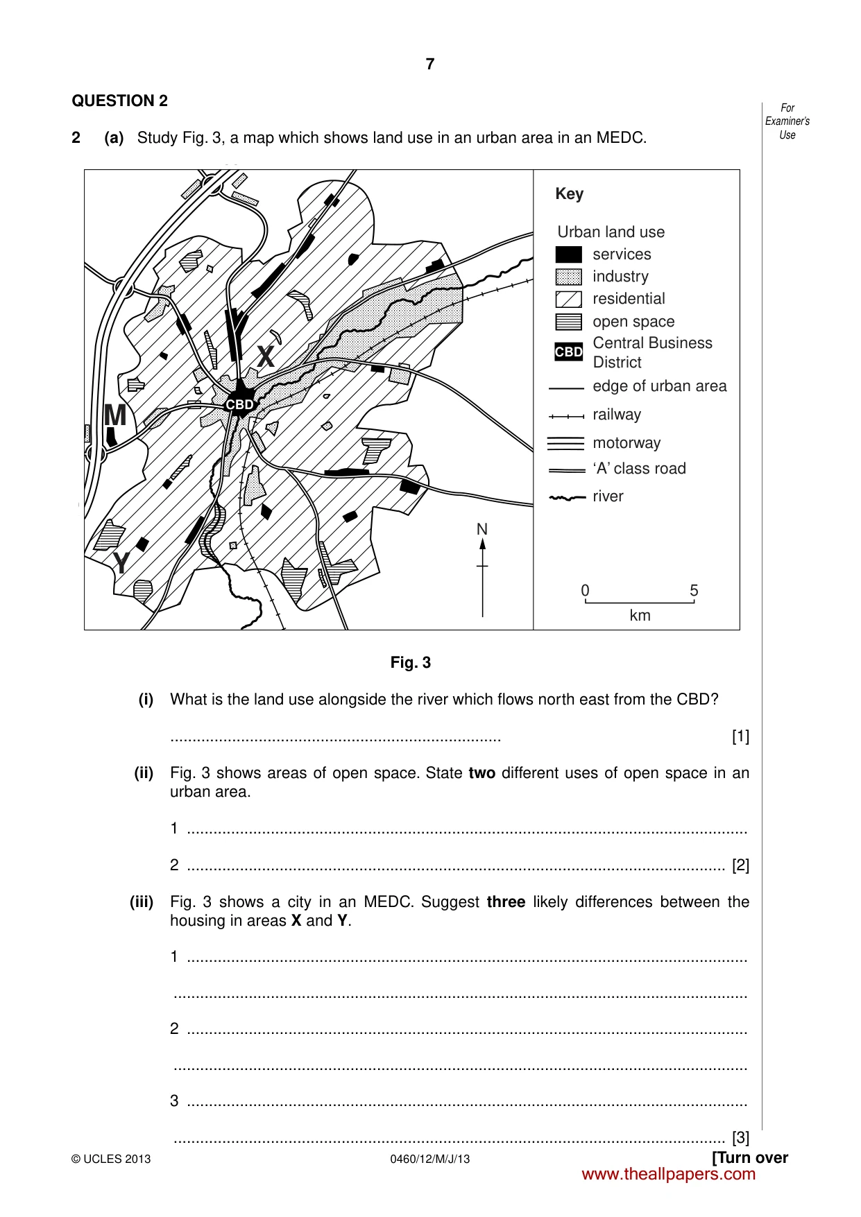
7 0460/12/M/J/13 © UCLES 2013 [Turn over For Examiner’s Use QUESTION 2 2 (a) Study Fig. 3, a map which shows land use in an urban area in an MEDC. X M Y N 0 5 km Key Urban land use services industry residential open space Central Business District edge of urban area railway ‘A’ class road motorway river CBD CBD Fig. 3 (i) What is the land use alongside the river which flows north east from the CBD? … [1] (ii) Fig. 3 shows areas of open space. State two different uses of open space in an urban area. 1 … 2 … [2] (iii) Fig. 3 shows a city in an MEDC. Suggest three likely differences between the housing in areas X and Y. 1 … … 2 … … 3 … … [3] www.theallpapers.com
Question paper, page 8
8 0460/12/M/J/13 © UCLES 2013 For Examiner’s Use (iv) Explain why M is a good location for an out of town shopping area. … … … … … … … … [4] (b) Study Photograph A (Insert), which shows part of the CBD in Hong Kong. (i) Using only evidence from Photograph A, describe three features of the CBD of Hong Kong. 1 … … 2 … … 3 … … [3] www.theallpapers.com
Question paper, page 9
9 0460/12/M/J/13 © UCLES 2013 [Turn over For Examiner’s Use (ii) Describe the problems for people using the CBD of a large urban area. … … … … … … … … … … [5] www.theallpapers.com
Question paper, page 10
10 0460/12/M/J/13 © UCLES 2013 For Examiner’s Use (c) Choose one problem of living in urban areas. For a named urban area, describe the attempts which have been made to solve the problem you have chosen. Name of urban area … Chosen problem … … … … … … … … … … … … … … … … [7] [Total: 25 marks] END OF QUESTION 2 www.theallpapers.com
Question paper, page 11
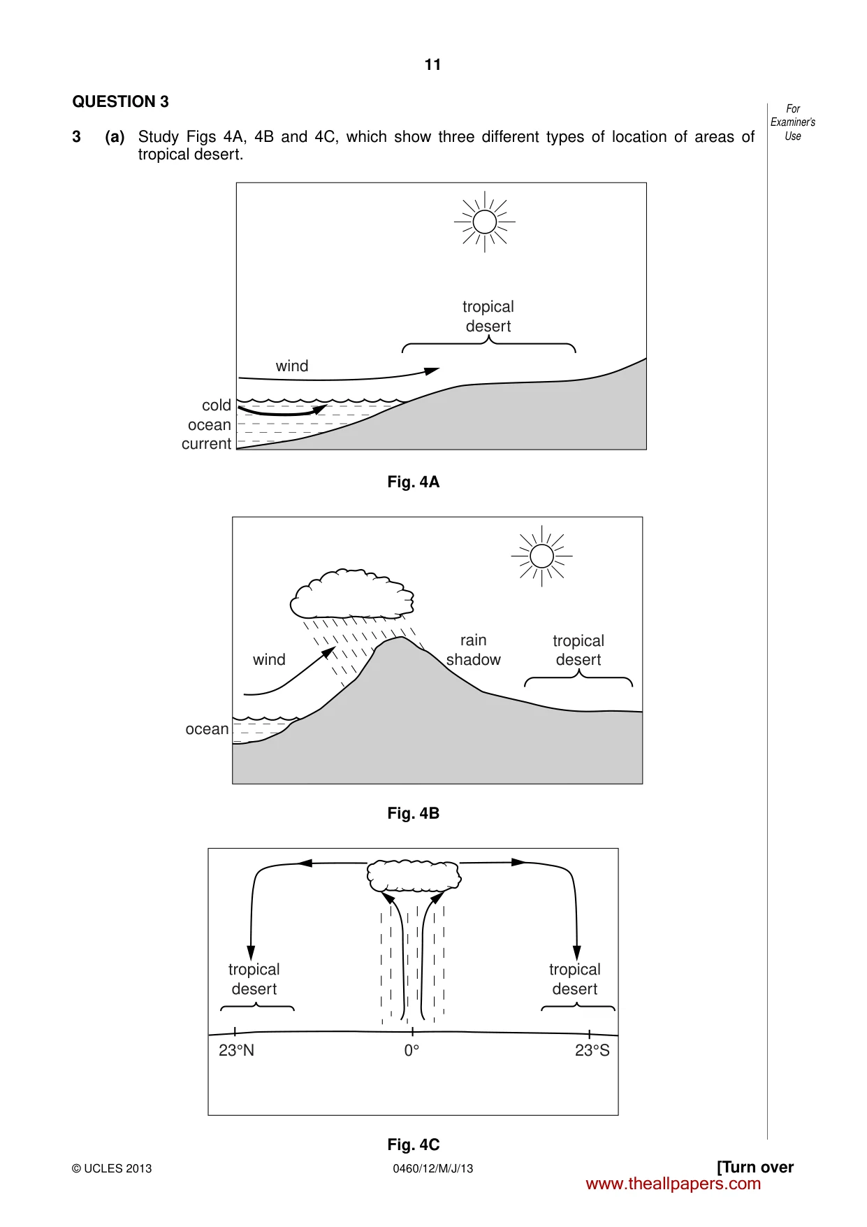
11 0460/12/M/J/13 © UCLES 2013 [Turn over For Examiner’s Use QUESTION 3 3 (a) Study Figs 4A, 4B and 4C, which show three different types of location of areas of tropical desert. wind tropical desert cold ocean current Fig. 4A wind ocean rain shadow tropical desert Fig. 4B tropical desert tropical desert 23°N 23°S 0° Fig. 4C www.theallpapers.com
Question paper, page 12
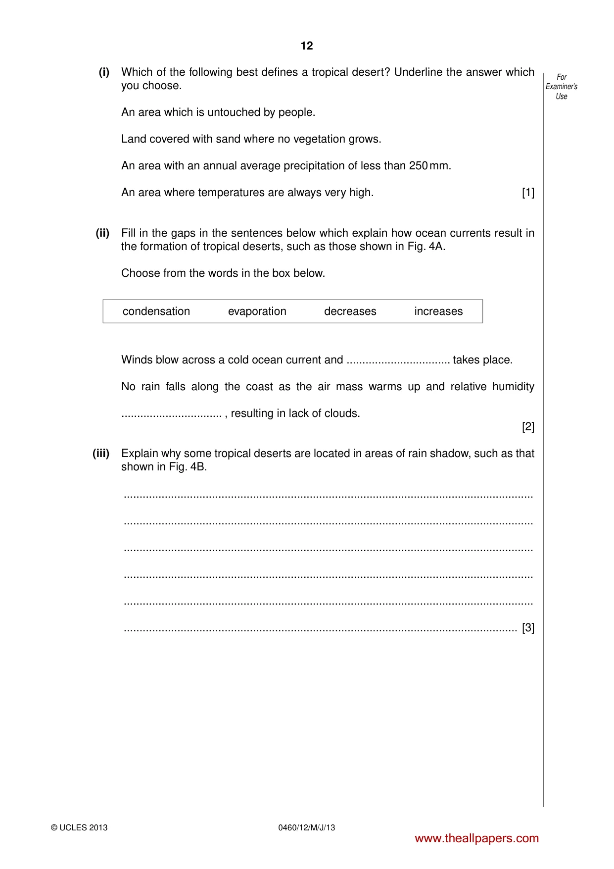
12 0460/12/M/J/13 © UCLES 2013 For Examiner’s Use (i) Which of the following best defines a tropical desert? Underline the answer which you choose. An area which is untouched by people. Land covered with sand where no vegetation grows. An area with an annual average precipitation of less than 250 mm. An area where temperatures are always very high. [1] (ii) Fill in the gaps in the sentences below which explain how ocean currents result in the formation of tropical deserts, such as those shown in Fig. 4A. Choose from the words in the box below. condensation evaporation decreases increases Winds blow across a cold ocean current and … takes place. No rain falls along the coast as the air mass warms up and relative humidity … , resulting in lack of clouds. [2] (iii) Explain why some tropical deserts are located in areas of rain shadow, such as that shown in Fig. 4B. … … … … … … [3] www.theallpapers.com
Question paper, page 13
13 0460/12/M/J/13 © UCLES 2013 [Turn over For Examiner’s Use (iv) Use the information in Fig. 4C to explain why many tropical deserts are located in areas close to 23° north and south of the Equator. … … … … … … … … [4] (b) Study Photograph B (Insert), which shows an area of tropical desert. (i) Describe three features of the area of tropical desert shown in Photograph B. 1 … … 2 … … 3 … … [3] www.theallpapers.com
Question paper, page 14
14 0460/12/M/J/13 © UCLES 2013 For Examiner’s Use (ii) Explain how the natural vegetation of tropical desert areas can survive in the hot, dry climate. … … … … … … … … … … [5] www.theallpapers.com
Question paper, page 15
15 0460/12/M/J/13 © UCLES 2013 [Turn over For Examiner’s Use (c) Another type of natural environment is tropical rain forest. Describe the impact of human activity on a tropical rain forest ecosystem which you have studied. Name of tropical rain forest … … … … … … … … … … … … … … … [7] [Total: 25 marks] END OF QUESTION 3 www.theallpapers.com
Question paper, page 16
16 0460/12/M/J/13 © UCLES 2013 For Examiner’s Use QUESTION 4 4 (a) Study Photograph C (Insert), which shows an area of coastline. (i) Identify the coastal landform shown by Photograph C. Underline the answer which you choose. cliff delta natural arch sand spit [1] (ii) Using only evidence from Photograph C, describe two features of this coastal landform. 1 … … 2 … … [2] (iii) Show how erosion affects coastlines like the one shown in Photograph C. To do so you should complete the sentences below by using arrows to match the correct beginnings and endings. The first sentence has been done for you. Hydraulic action erodes the coast when the materials carried by the waves hit the rocks Corrasion makes rocks smaller as they hit each other in the waves Corrosion wears away the rocks by the weight and power of the waves Attrition dissolves the rocks by chemical reactions [3] www.theallpapers.com
Question paper, page 17
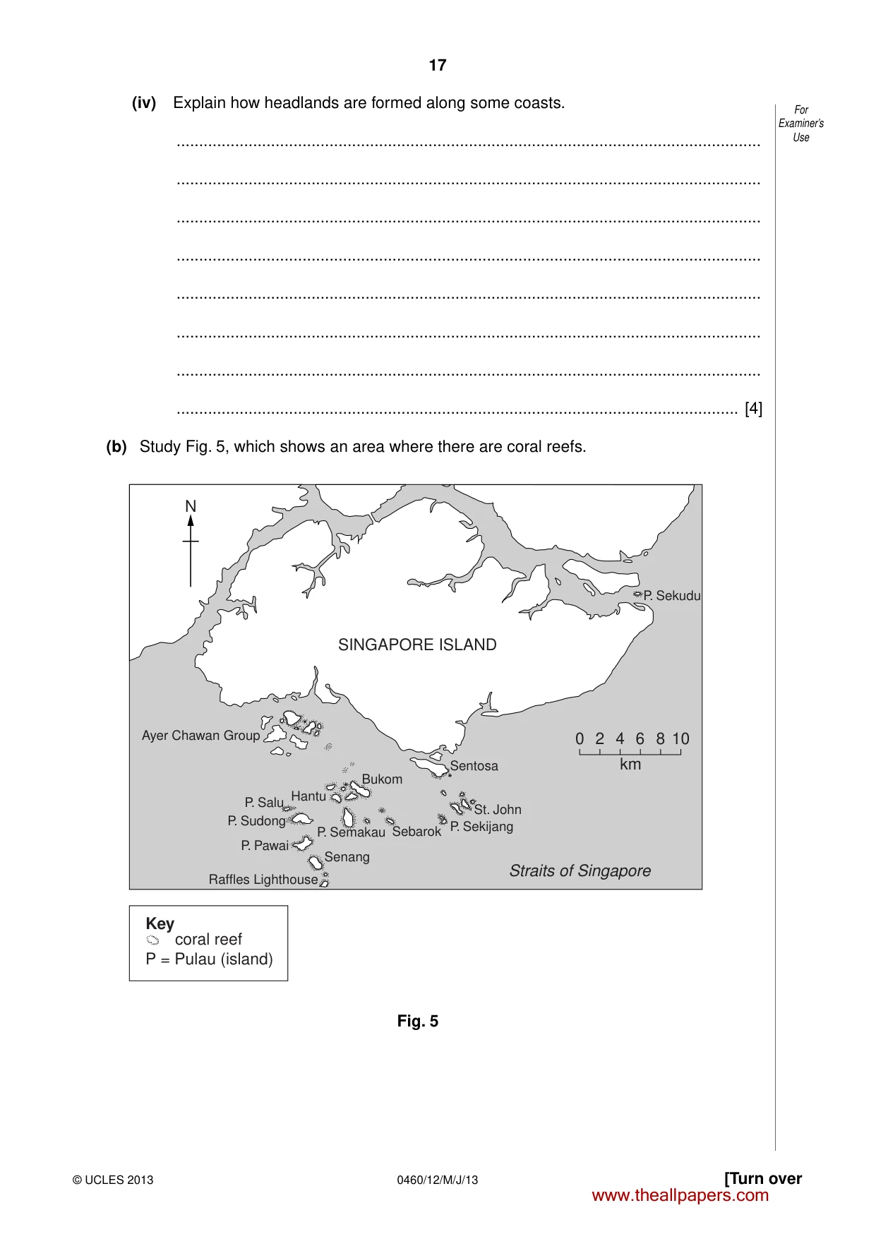
17 0460/12/M/J/13 © UCLES 2013 [Turn over For Examiner’s Use (iv) Explain how headlands are formed along some coasts. … … … … … … … … [4] (b) Study Fig. 5, which shows an area where there are coral reefs. Key coral reef P = Pulau (island) 0 2 4 6 8 10 km Raffles Lighthouse Senang P. Pawai P. Sudong P. Salu P. Sekudu Hantu Bukom P. Semakau Sebarok Sentosa P. Sekijang St. John Ayer Chawan Group SINGAPORE ISLAND N Straits of Singapore Fig. 5 www.theallpapers.com
Question paper, page 18
18 0460/12/M/J/13 © UCLES 2013 For Examiner’s Use (i) Describe the distribution of coral reefs shown in Fig. 5. … … … … … … [3] (ii) Explain why coral reefs are only found in some sea areas. … … … … … … … … … … [5] www.theallpapers.com
Question paper, page 19
19 0460/12/M/J/13 © UCLES 2013 [Turn over For Examiner’s Use (c) For a named area which you have studied, describe the impacts of a tropical storm. Name of area … … … … … … … … … … … … … … … [7] [Total: 25 marks] END OF QUESTION 4 www.theallpapers.com
Question paper, page 20
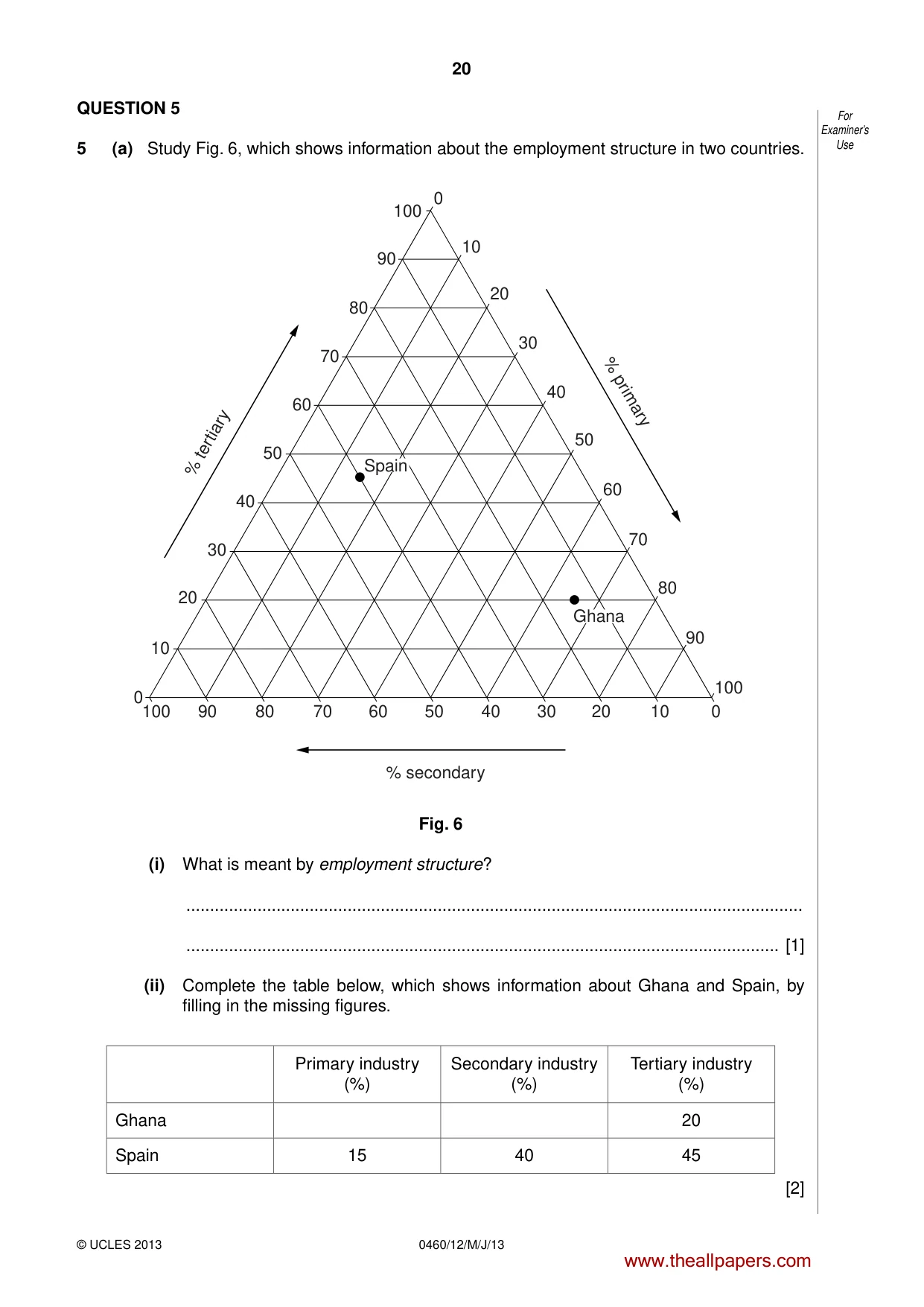
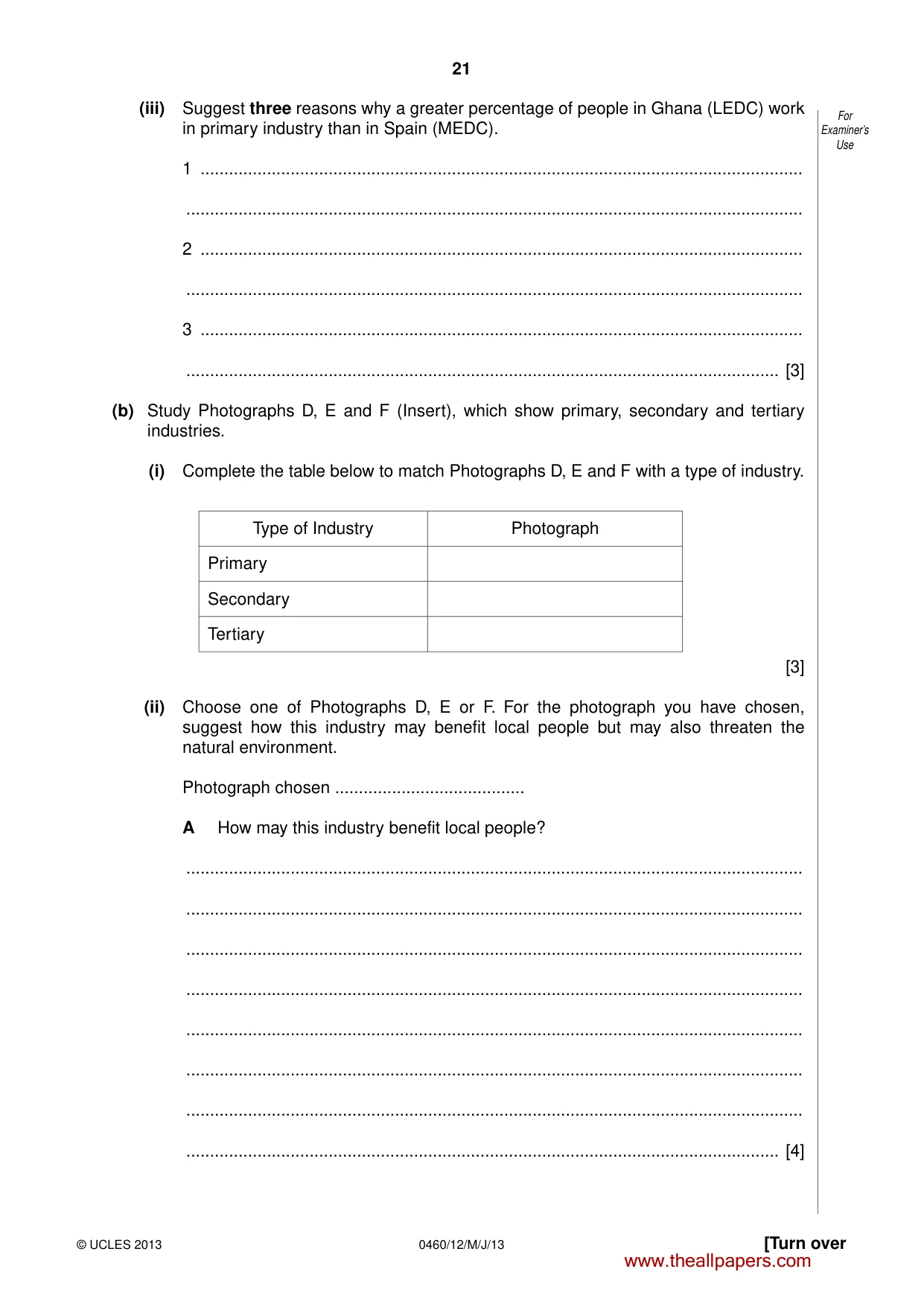
20 0460/12/M/J/13 © UCLES 2013 For Examiner’s Use QUESTION 5 5 (a) Study Fig. 6, which shows information about the employment structure in two countries. 0 0 10 20 30 40 50 60 70 80 90 100 10 20 30 40 50 60 70 80 90 100 100 90 80 70 60 50 40 30 20 10 0 % tertiary % primary % secondary Spain Ghana Fig. 6 (i) What is meant by employment structure? … … [1] (ii) Complete the table below, which shows information about Ghana and Spain, by filling in the missing figures. Primary industry (%) Secondary industry (%) Tertiary industry (%) Ghana 20 Spain 15 40 45 [2] www.theallpapers.com
Question paper, page 21
21 0460/12/M/J/13 © UCLES 2013 [Turn over For Examiner’s Use (iii) Suggest three reasons why a greater percentage of people in Ghana (LEDC) work in primary industry than in Spain (MEDC). 1 … … 2 … … 3 … … [3] (b) Study Photographs D, E and F (Insert), which show primary, secondary and tertiary industries. (i) Complete the table below to match Photographs D, E and F with a type of industry. Type of Industry Photograph Primary Secondary Tertiary [3] (ii) Choose one of Photographs D, E or F. For the photograph you have chosen, suggest how this industry may benefit local people but may also threaten the natural environment. Photograph chosen … A How may this industry benefit local people? … … … … … … … … [4] www.theallpapers.com
Question paper, page 22
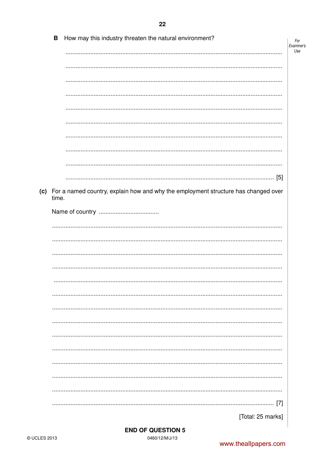
22 0460/12/M/J/13 © UCLES 2013 For Examiner’s Use B How may this industry threaten the natural environment? … … … … … … … … … … [5] (c) For a named country, explain how and why the employment structure has changed over time. Name of country … … … … … … … … … … … … … … … [7] [Total: 25 marks] END OF QUESTION 5 www.theallpapers.com
Question paper, page 23
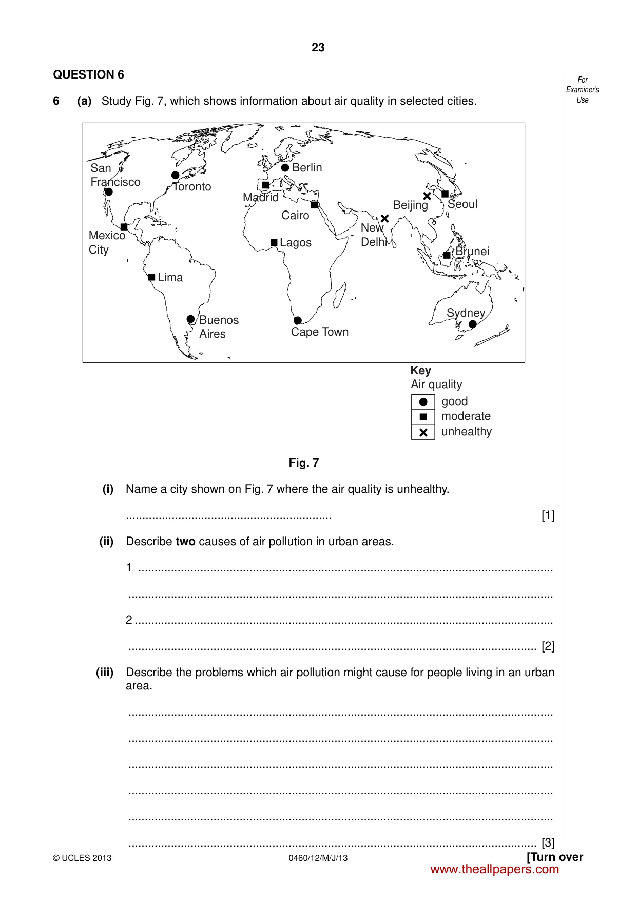
23 0460/12/M/J/13 © UCLES 2013 [Turn over For Examiner’s Use QUESTION 6 6 (a) Study Fig. 7, which shows information about air quality in selected cities. San Francisco Toronto Berlin Madrid Lagos Cairo Mexico City Lima Buenos Aires Cape Town Sydney Brunei Beijing Seoul good moderate unhealthy Key Air quality New Delhi Fig. 7 (i) Name a city shown on Fig. 7 where the air quality is unhealthy. … [1] (ii) Describe two causes of air pollution in urban areas. 1 … … 2 … … [2] (iii) Describe the problems which air pollution might cause for people living in an urban area. … … … … … … [3] www.theallpapers.com
Question paper, page 24
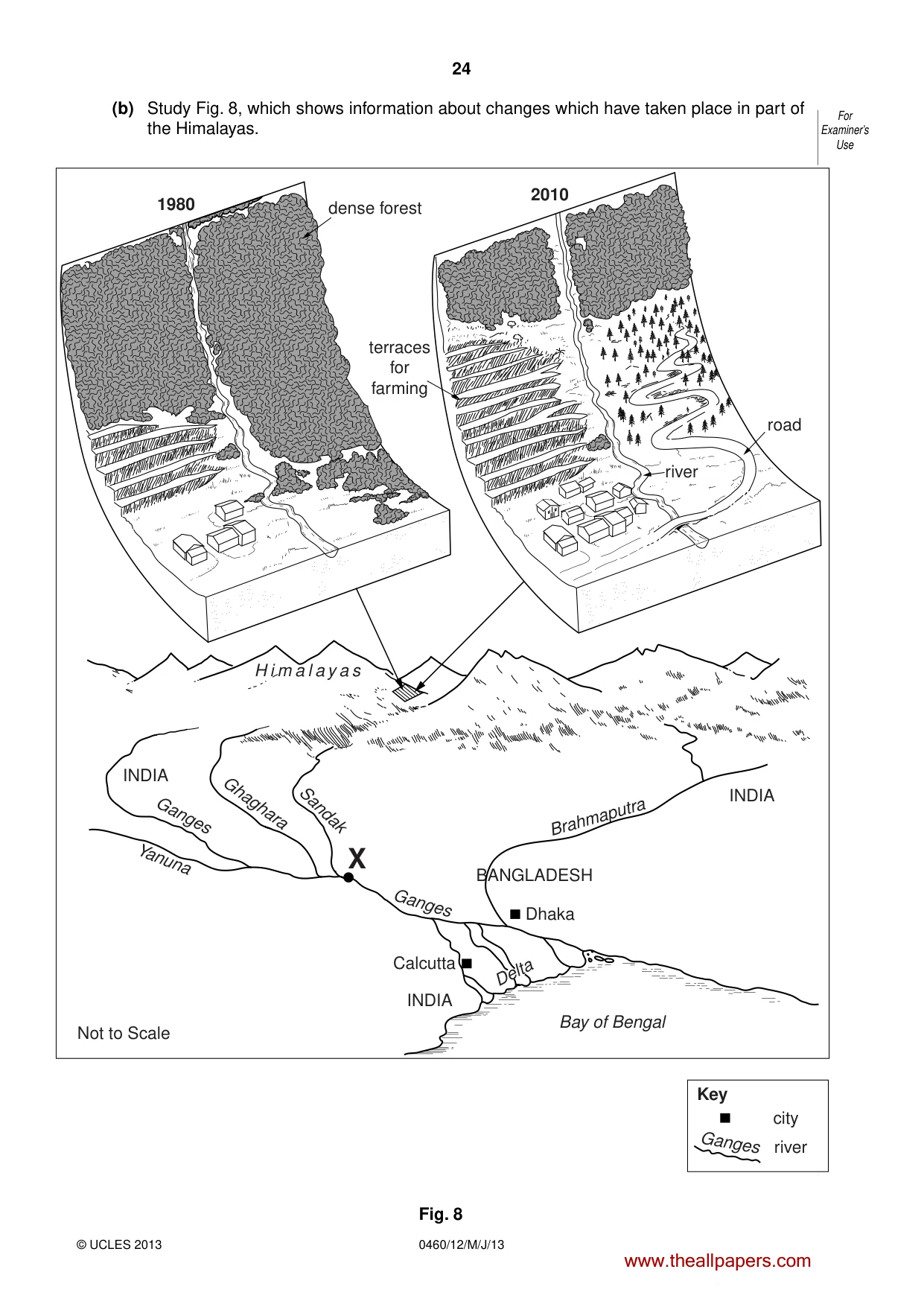
24 0460/12/M/J/13 © UCLES 2013 For Examiner’s Use (b) Study Fig. 8, which shows information about changes which have taken place in part of the Himalayas. dense forest terraces for farming road 1980 2010 INDIA INDIA INDIA Not to Scale BANGLADESH Brahmaputra Ganges Delta Sandak Ghaghara Ganges Yanuna Calcutta Dhaka H i m a l a y a s Bay of Bengal X river Key city river Ganges Fig. 8 www.theallpapers.com
Question paper, page 25
25 0460/12/M/J/13 © UCLES 2013 [Turn over For Examiner’s Use (i) Identify three changes which have taken place in the area shown in Fig. 8 between 1980 and 2010. 1 … … 2 … … 3 … … [3] (ii) Explain why the changes shown in Fig. 8 are likely to cause increased risks of flooding at X. … … … … … … … … [4] www.theallpapers.com
Question paper, page 26
26 0460/12/M/J/13 © UCLES 2013 For Examiner’s Use (iii) Explain how the changes shown in Fig. 8 may cause other threats to the natural environment. You should not write about flooding. … … … … … … … … … … [5] www.theallpapers.com
Question paper, page 27
27 0460/12/M/J/13 © UCLES 2013 [Turn over For Examiner’s Use (c) Name an example of a sea, lake or river which has been polluted by human activity and explain the causes of this pollution. Name of example … … … … … … … … … … … … … … … [7] [Total: 25 marks] END OF QUESTION 6 www.theallpapers.com
Question paper, page 28
28 0460/12/M/J/13 © UCLES 2013 For Examiner’s Use Additional Page If you use the following lines to complete the answer(s) to any question(s), the question number(s) must be clearly shown. … … … … … … … … … … … … … … … … … … … … … Copyright Acknowledgements: Question 2 Photograph A S Sibley © UCLES. Question 3 Photograph B S Sibley © UCLES. Question 4 Photograph C S Sibley © UCLES. Question 5 Photographs D, E & F S Sibley © UCLES. Permission to reproduce items where third-party owned material protected by copyright is included has been sought and cleared where possible. Every reasonable effort has been made by the publisher (UCLES) to trace copyright holders, but if any items requiring clearance have unwittingly been included, the publisher will be pleased to make amends at the earliest possible opportunity. University of Cambridge International Examinations is part of the Cambridge Assessment Group. Cambridge Assessment is the brand name of University of Cambridge Local Examinations Syndicate (UCLES), which is itself a department of the University of Cambridge. www.theallpapers.com
Mark scheme, page 1
CAMBRIDGE INTERNATIONAL EXAMINATIONS International General Certificate of Secondary Education MARK SCHEME for the May/June 2013 series 0460 GEOGRAPHY 0460/12 Paper 1, maximum raw mark 75 This mark scheme is published as an aid to teachers and candidates, to indicate the requirements of the examination. It shows the basis on which Examiners were instructed to award marks. It does not indicate the details of the discussions that took place at an Examiners’ meeting before marking began, which would have considered the acceptability of alternative answers. Mark schemes should be read in conjunction with the question paper and the Principal Examiner Report for Teachers. Cambridge will not enter into discussions about these mark schemes. Cambridge is publishing the mark schemes for the May/June 2013 series for most IGCSE, GCE Advanced Level and Advanced Subsidiary Level components and some Ordinary Level components. www.theallpapers.com
Mark scheme, page 2
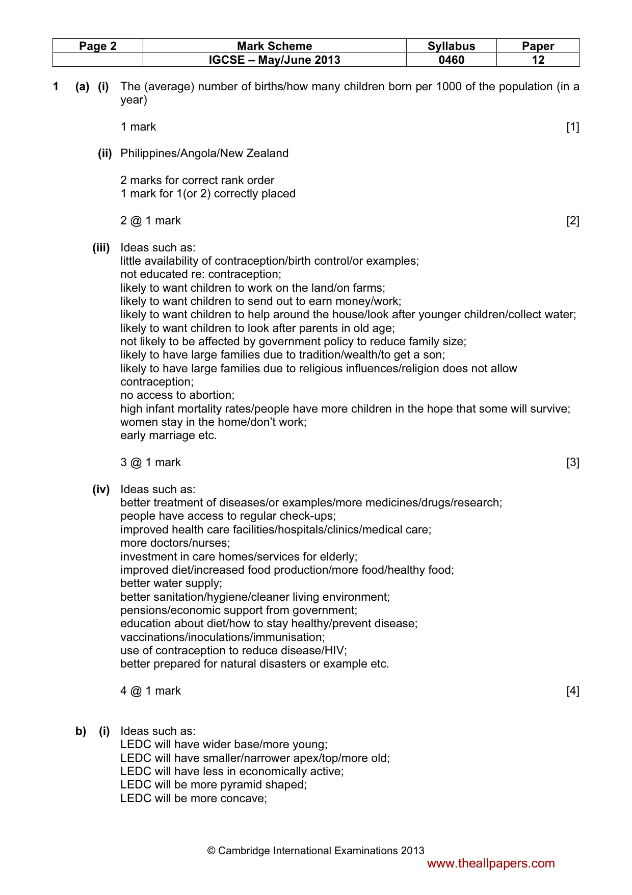
Page 2 Mark Scheme Syllabus Paper IGCSE – May/June 2013 0460 12 © Cambridge International Examinations 2013 1 (a) (i) The (average) number of births/how many children born per 1000 of the population (in a year) 1 mark [1] (ii) Philippines/Angola/New Zealand 2 marks for correct rank order 1 mark for 1(or 2) correctly placed 2 @ 1 mark [2] (iii) Ideas such as: little availability of contraception/birth control/or examples; not educated re: contraception; likely to want children to work on the land/on farms; likely to want children to send out to earn money/work; likely to want children to help around the house/look after younger children/collect water; likely to want children to look after parents in old age; not likely to be affected by government policy to reduce family size; likely to have large families due to tradition/wealth/to get a son; likely to have large families due to religious influences/religion does not allow contraception; no access to abortion; high infant mortality rates/people have more children in the hope that some will survive; women stay in the home/don’t work; early marriage etc. 3 @ 1 mark [3] (iv) Ideas such as: better treatment of diseases/or examples/more medicines/drugs/research; people have access to regular check-ups; improved health care facilities/hospitals/clinics/medical care; more doctors/nurses; investment in care homes/services for elderly; improved diet/increased food production/more food/healthy food; better water supply; better sanitation/hygiene/cleaner living environment; pensions/economic support from government; education about diet/how to stay healthy/prevent disease; vaccinations/inoculations/immunisation; use of contraception to reduce disease/HIV; better prepared for natural disasters or example etc. 4 @ 1 mark [4] b) (i) Ideas such as: LEDC will have wider base/more young; LEDC will have smaller/narrower apex/top/more old; LEDC will have less in economically active; LEDC will be more pyramid shaped; LEDC will be more concave; www.theallpapers.com
Mark scheme, page 3
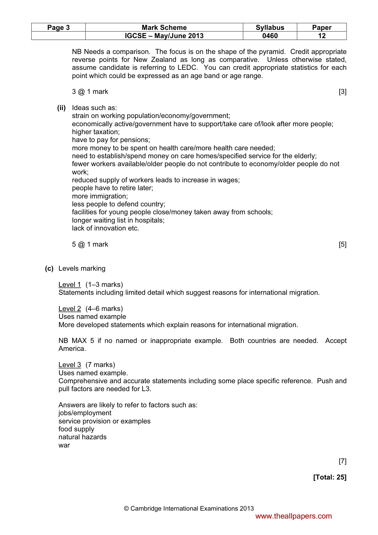
Page 3 Mark Scheme Syllabus Paper IGCSE – May/June 2013 0460 12 © Cambridge International Examinations 2013 NB Needs a comparison. The focus is on the shape of the pyramid. Credit appropriate reverse points for New Zealand as long as comparative. Unless otherwise stated, assume candidate is referring to LEDC. You can credit appropriate statistics for each point which could be expressed as an age band or age range. 3 @ 1 mark [3] (ii) Ideas such as: strain on working population/economy/government; economically active/government have to support/take care of/look after more people; higher taxation; have to pay for pensions; more money to be spent on health care/more health care needed; need to establish/spend money on care homes/specified service for the elderly; fewer workers available/older people do not contribute to economy/older people do not work; reduced supply of workers leads to increase in wages; people have to retire later; more immigration; less people to defend country; facilities for young people close/money taken away from schools; longer waiting list in hospitals; lack of innovation etc. 5 @ 1 mark [5] (c) Levels marking Level 1 (1–3 marks) Statements including limited detail which suggest reasons for international migration. Level 2 (4–6 marks) Uses named example More developed statements which explain reasons for international migration. NB MAX 5 if no named or inappropriate example. Both countries are needed. Accept America. Level 3 (7 marks) Uses named example. Comprehensive and accurate statements including some place specific reference. Push and pull factors are needed for L3. Answers are likely to refer to factors such as: jobs/employment service provision or examples food supply natural hazards war [7] [Total: 25] www.theallpapers.com
Mark scheme, page 4
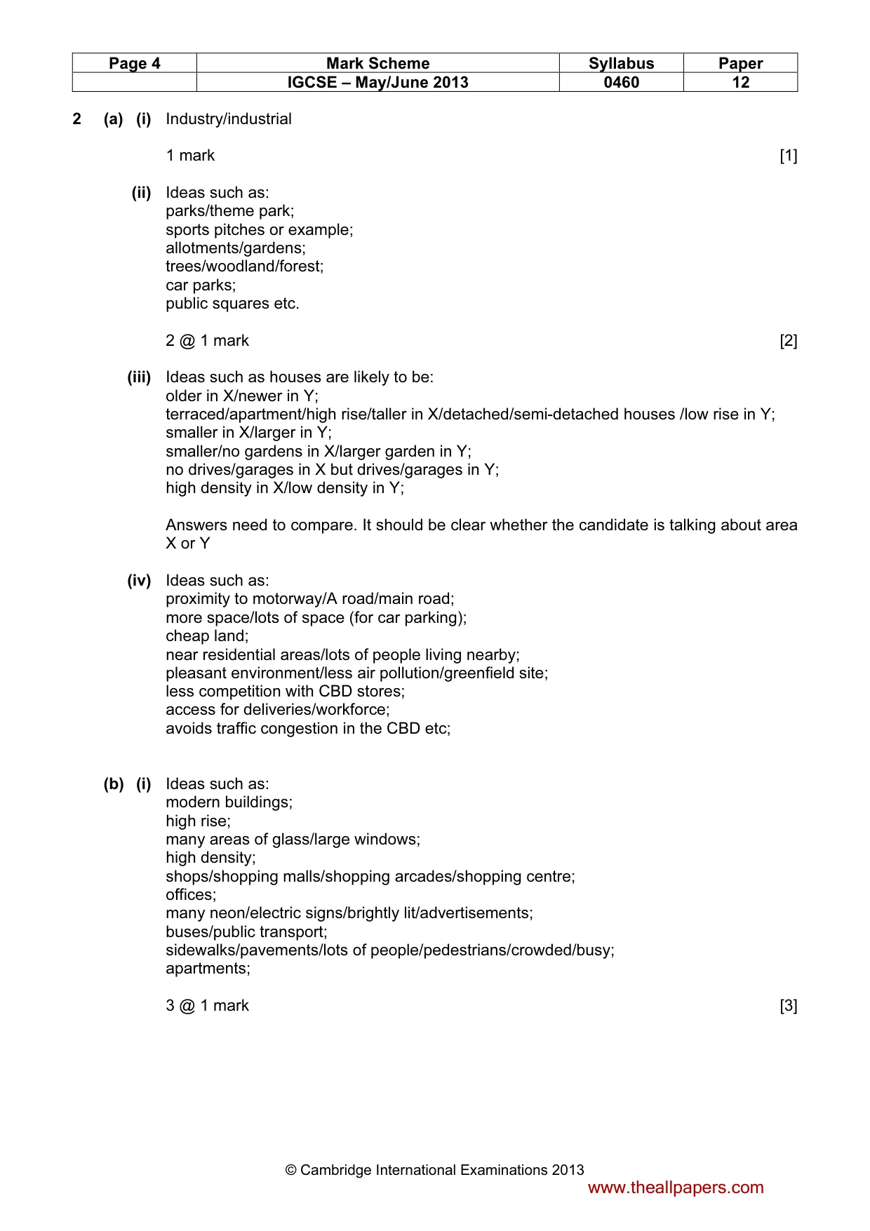
Page 4 Mark Scheme Syllabus Paper IGCSE – May/June 2013 0460 12 © Cambridge International Examinations 2013 2 (a) (i) Industry/industrial 1 mark [1] (ii) Ideas such as: parks/theme park; sports pitches or example; allotments/gardens; trees/woodland/forest; car parks; public squares etc. 2 @ 1 mark [2] (iii) Ideas such as houses are likely to be: older in X/newer in Y; terraced/apartment/high rise/taller in X/detached/semi-detached houses /low rise in Y; smaller in X/larger in Y; smaller/no gardens in X/larger garden in Y; no drives/garages in X but drives/garages in Y; high density in X/low density in Y; Answers need to compare. It should be clear whether the candidate is talking about area X or Y (iv) Ideas such as: proximity to motorway/A road/main road; more space/lots of space (for car parking); cheap land; near residential areas/lots of people living nearby; pleasant environment/less air pollution/greenfield site; less competition with CBD stores; access for deliveries/workforce; avoids traffic congestion in the CBD etc; (b) (i) Ideas such as: modern buildings; high rise; many areas of glass/large windows; high density; shops/shopping malls/shopping arcades/shopping centre; offices; many neon/electric signs/brightly lit/advertisements; buses/public transport; sidewalks/pavements/lots of people/pedestrians/crowded/busy; apartments; 3 @ 1 mark [3] www.theallpapers.com
Mark scheme, page 5
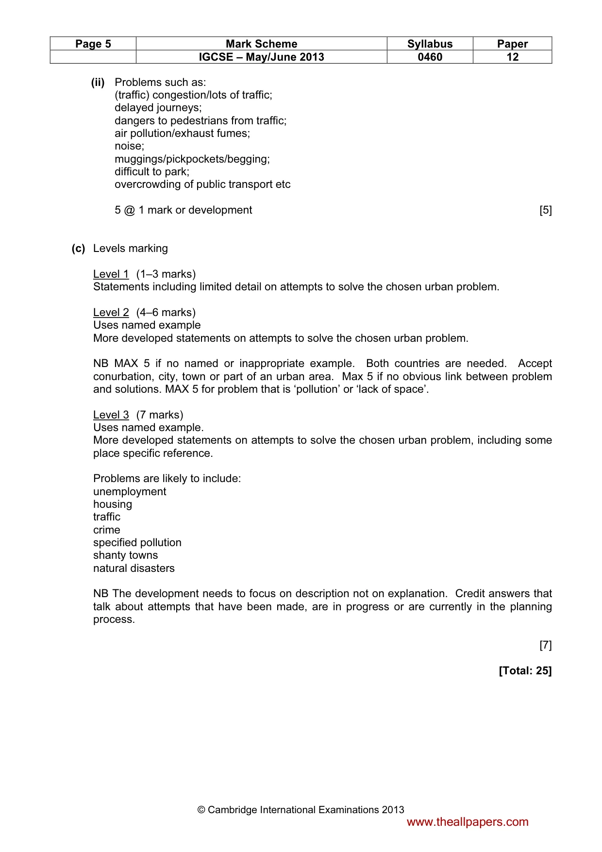
Page 5 Mark Scheme Syllabus Paper IGCSE – May/June 2013 0460 12 © Cambridge International Examinations 2013 (ii) Problems such as: (traffic) congestion/lots of traffic; delayed journeys; dangers to pedestrians from traffic; air pollution/exhaust fumes; noise; muggings/pickpockets/begging; difficult to park; overcrowding of public transport etc 5 @ 1 mark or development [5] (c) Levels marking Level 1 (1–3 marks) Statements including limited detail on attempts to solve the chosen urban problem. Level 2 (4–6 marks) Uses named example More developed statements on attempts to solve the chosen urban problem. NB MAX 5 if no named or inappropriate example. Both countries are needed. Accept conurbation, city, town or part of an urban area. Max 5 if no obvious link between problem and solutions. MAX 5 for problem that is ‘pollution’ or ‘lack of space’. Level 3 (7 marks) Uses named example. More developed statements on attempts to solve the chosen urban problem, including some place specific reference. Problems are likely to include: unemployment housing traffic crime specified pollution shanty towns natural disasters NB The development needs to focus on description not on explanation. Credit answers that talk about attempts that have been made, are in progress or are currently in the planning process. [7] [Total: 25] www.theallpapers.com
Mark scheme, page 6
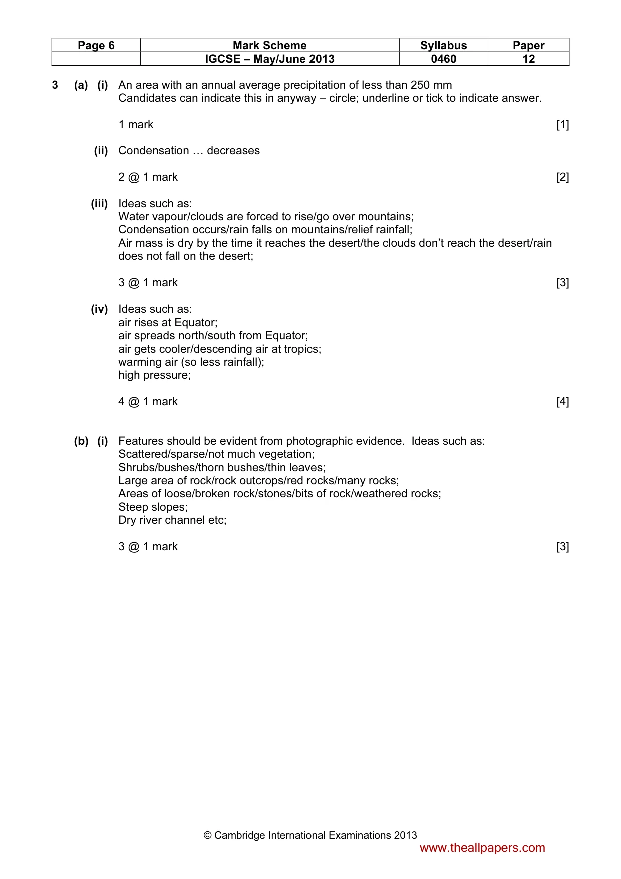
Page 6 Mark Scheme Syllabus Paper IGCSE – May/June 2013 0460 12 © Cambridge International Examinations 2013 3 (a) (i) An area with an annual average precipitation of less than 250 mm Candidates can indicate this in anyway – circle; underline or tick to indicate answer. 1 mark [1] (ii) Condensation … decreases 2 @ 1 mark [2] (iii) Ideas such as: Water vapour/clouds are forced to rise/go over mountains; Condensation occurs/rain falls on mountains/relief rainfall; Air mass is dry by the time it reaches the desert/the clouds don’t reach the desert/rain does not fall on the desert; 3 @ 1 mark [3] (iv) Ideas such as: air rises at Equator; air spreads north/south from Equator; air gets cooler/descending air at tropics; warming air (so less rainfall); high pressure; 4 @ 1 mark [4] (b) (i) Features should be evident from photographic evidence. Ideas such as: Scattered/sparse/not much vegetation; Shrubs/bushes/thorn bushes/thin leaves; Large area of rock/rock outcrops/red rocks/many rocks; Areas of loose/broken rock/stones/bits of rock/weathered rocks; Steep slopes; Dry river channel etc; 3 @ 1 mark [3] www.theallpapers.com
Mark scheme, page 7
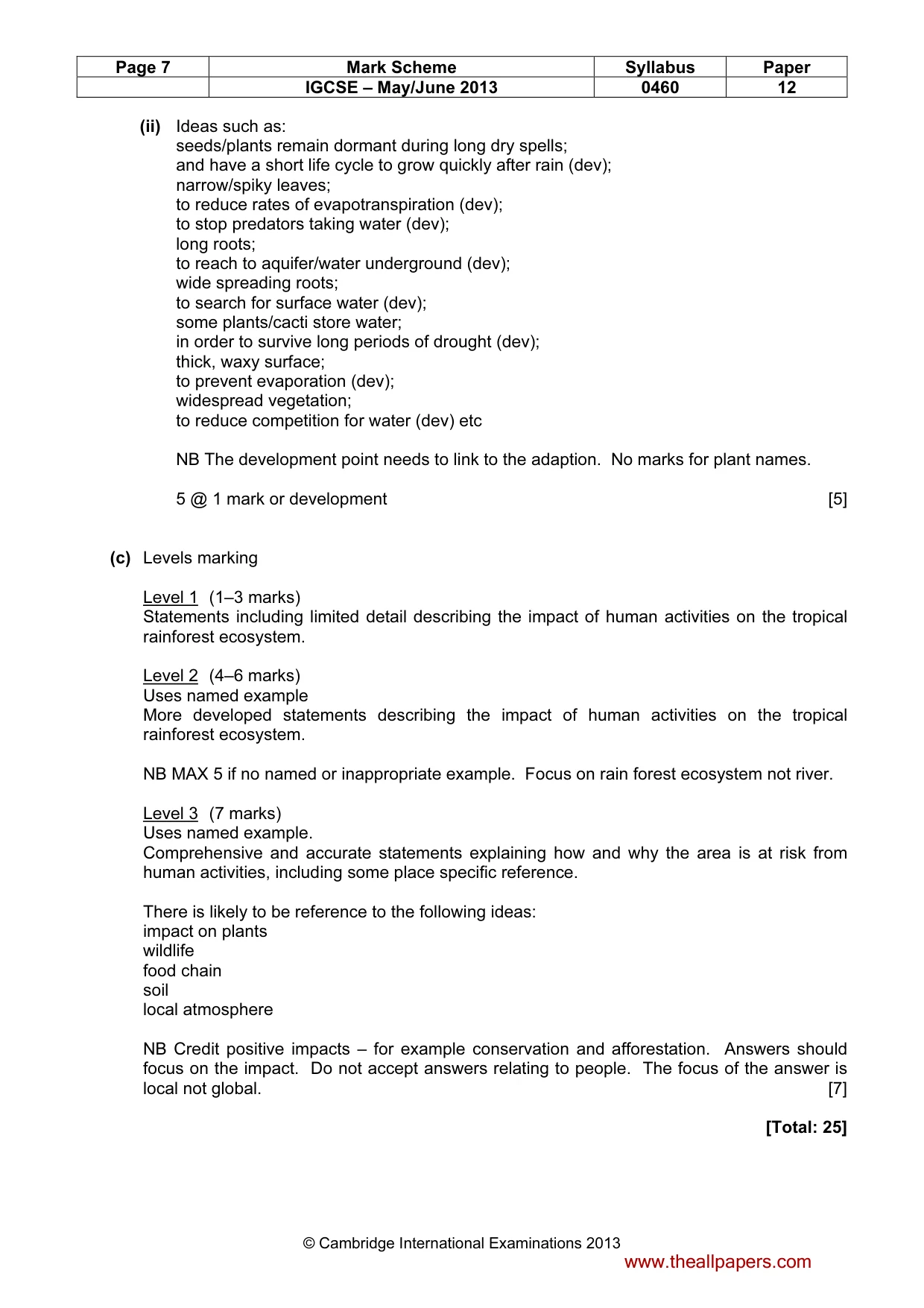
Page 7 Mark Scheme Syllabus Paper IGCSE – May/June 2013 0460 12 © Cambridge International Examinations 2013 (ii) Ideas such as: seeds/plants remain dormant during long dry spells; and have a short life cycle to grow quickly after rain (dev); narrow/spiky leaves; to reduce rates of evapotranspiration (dev); to stop predators taking water (dev); long roots; to reach to aquifer/water underground (dev); wide spreading roots; to search for surface water (dev); some plants/cacti store water; in order to survive long periods of drought (dev); thick, waxy surface; to prevent evaporation (dev); widespread vegetation; to reduce competition for water (dev) etc NB The development point needs to link to the adaption. No marks for plant names. 5 @ 1 mark or development [5] (c) Levels marking Level 1 (1–3 marks) Statements including limited detail describing the impact of human activities on the tropical rainforest ecosystem. Level 2 (4–6 marks) Uses named example More developed statements describing the impact of human activities on the tropical rainforest ecosystem. NB MAX 5 if no named or inappropriate example. Focus on rain forest ecosystem not river. Level 3 (7 marks) Uses named example. Comprehensive and accurate statements explaining how and why the area is at risk from human activities, including some place specific reference. There is likely to be reference to the following ideas: impact on plants wildlife food chain soil local atmosphere NB Credit positive impacts – for example conservation and afforestation. Answers should focus on the impact. Do not accept answers relating to people. The focus of the answer is local not global. [7] [Total: 25] www.theallpapers.com
Mark scheme, page 8
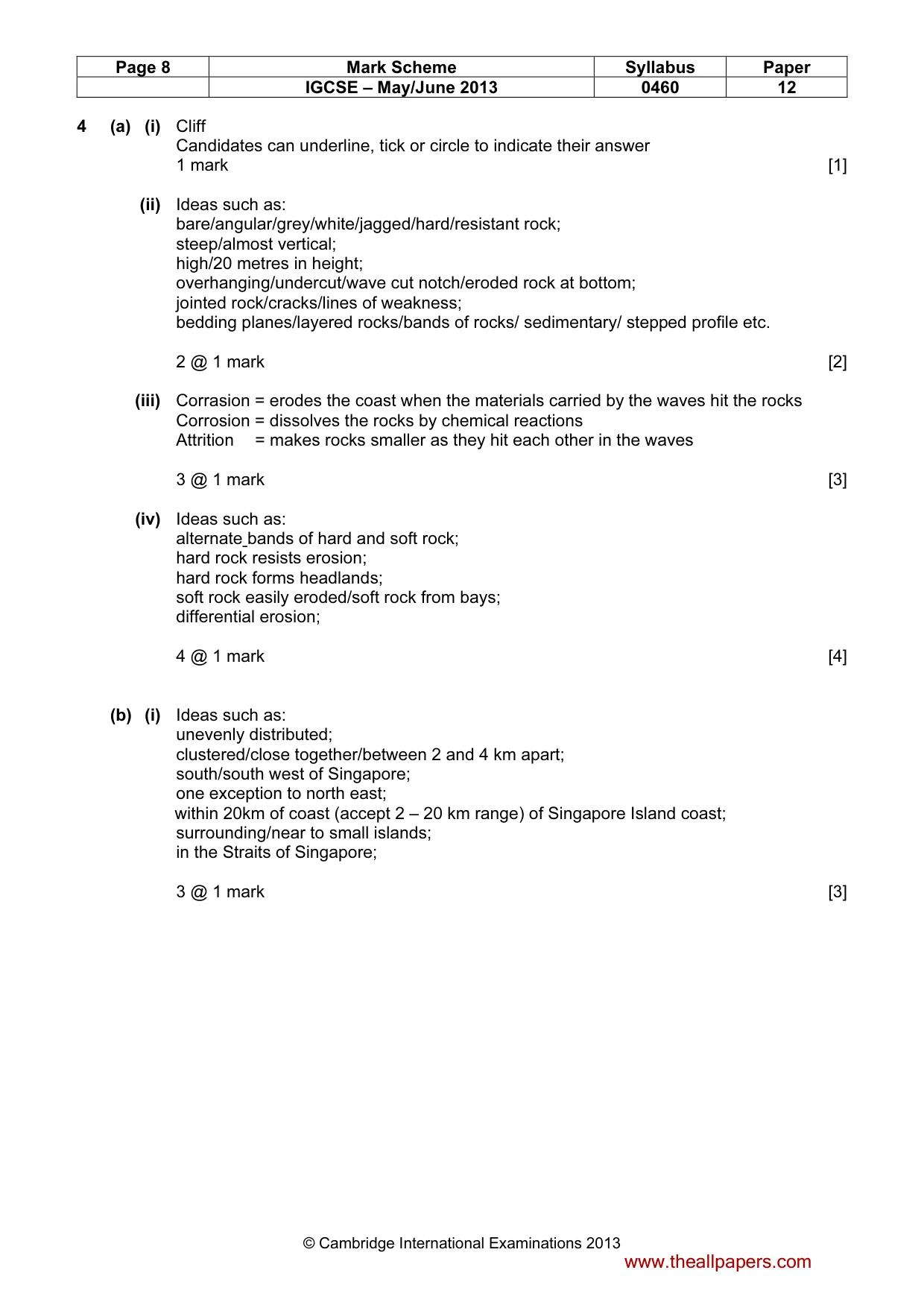
Page 8 Mark Scheme Syllabus Paper IGCSE – May/June 2013 0460 12 © Cambridge International Examinations 2013 4 (a) (i) Cliff Candidates can underline, tick or circle to indicate their answer 1 mark [1] (ii) Ideas such as: bare/angular/grey/white/jagged/hard/resistant rock; steep/almost vertical; high/20 metres in height; overhanging/undercut/wave cut notch/eroded rock at bottom; jointed rock/cracks/lines of weakness; bedding planes/layered rocks/bands of rocks/ sedimentary/ stepped profile etc. 2 @ 1 mark [2] (iii) Corrasion = erodes the coast when the materials carried by the waves hit the rocks Corrosion = dissolves the rocks by chemical reactions Attrition = makes rocks smaller as they hit each other in the waves 3 @ 1 mark [3] (iv) Ideas such as: alternate bands of hard and soft rock; hard rock resists erosion; hard rock forms headlands; soft rock easily eroded/soft rock from bays; differential erosion; 4 @ 1 mark [4] (b) (i) Ideas such as: unevenly distributed; clustered/close together/between 2 and 4 km apart; south/south west of Singapore; one exception to north east; within 20km of coast (accept 2 – 20 km range) of Singapore Island coast; surrounding/near to small islands; in the Straits of Singapore; 3 @ 1 mark [3] www.theallpapers.com
Mark scheme, page 9
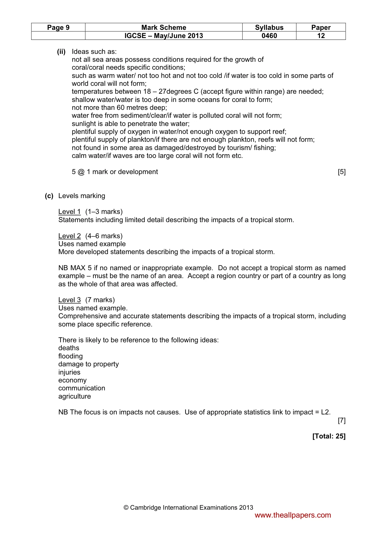
Page 9 Mark Scheme Syllabus Paper IGCSE – May/June 2013 0460 12 © Cambridge International Examinations 2013 (ii) Ideas such as: not all sea areas possess conditions required for the growth of coral/coral needs specific conditions; such as warm water/ not too hot and not too cold /if water is too cold in some parts of world coral will not form; temperatures between 18 – 27degrees C (accept figure within range) are needed; shallow water/water is too deep in some oceans for coral to form; not more than 60 metres deep; water free from sediment/clear/if water is polluted coral will not form; sunlight is able to penetrate the water; plentiful supply of oxygen in water/not enough oxygen to support reef; plentiful supply of plankton/if there are not enough plankton, reefs will not form; not found in some area as damaged/destroyed by tourism/ fishing; calm water/if waves are too large coral will not form etc. 5 @ 1 mark or development [5] (c) Levels marking Level 1 (1–3 marks) Statements including limited detail describing the impacts of a tropical storm. Level 2 (4–6 marks) Uses named example More developed statements describing the impacts of a tropical storm. NB MAX 5 if no named or inappropriate example. Do not accept a tropical storm as named example – must be the name of an area. Accept a region country or part of a country as long as the whole of that area was affected. Level 3 (7 marks) Uses named example. Comprehensive and accurate statements describing the impacts of a tropical storm, including some place specific reference. There is likely to be reference to the following ideas: deaths flooding damage to property injuries economy communication agriculture NB The focus is on impacts not causes. Use of appropriate statistics link to impact = L2. [7] [Total: 25] www.theallpapers.com
Mark scheme, page 10
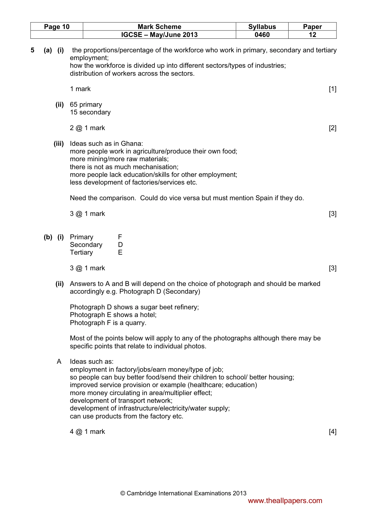
Page 10 Mark Scheme Syllabus Paper IGCSE – May/June 2013 0460 12 © Cambridge International Examinations 2013 5 (a) (i) the proportions/percentage of the workforce who work in primary, secondary and tertiary employment; how the workforce is divided up into different sectors/types of industries; distribution of workers across the sectors. 1 mark [1] (ii) 65 primary 15 secondary 2 @ 1 mark [2] (iii) Ideas such as in Ghana: more people work in agriculture/produce their own food; more mining/more raw materials; there is not as much mechanisation; more people lack education/skills for other employment; less development of factories/services etc. Need the comparison. Could do vice versa but must mention Spain if they do. 3 @ 1 mark [3] (b) (i) Primary F Secondary D Tertiary E 3 @ 1 mark [3] (ii) Answers to A and B will depend on the choice of photograph and should be marked accordingly e.g. Photograph D (Secondary) Photograph D shows a sugar beet refinery; Photograph E shows a hotel; Photograph F is a quarry. Most of the points below will apply to any of the photographs although there may be specific points that relate to individual photos. A Ideas such as: employment in factory/jobs/earn money/type of job; so people can buy better food/send their children to school/ better housing; improved service provision or example (healthcare; education) more money circulating in area/multiplier effect; development of transport network; development of infrastructure/electricity/water supply; can use products from the factory etc. 4 @ 1 mark [4] www.theallpapers.com
Mark scheme, page 11
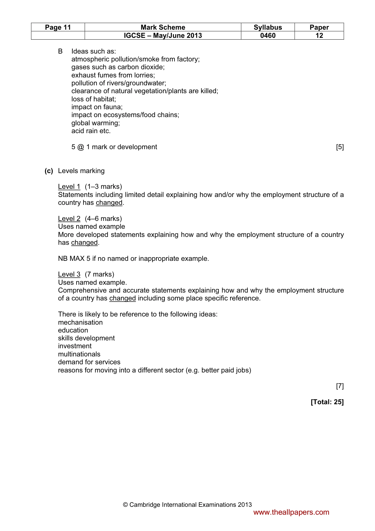
Page 11 Mark Scheme Syllabus Paper IGCSE – May/June 2013 0460 12 © Cambridge International Examinations 2013 B Ideas such as: atmospheric pollution/smoke from factory; gases such as carbon dioxide; exhaust fumes from lorries; pollution of rivers/groundwater; clearance of natural vegetation/plants are killed; loss of habitat; impact on fauna; impact on ecosystems/food chains; global warming; acid rain etc. 5 @ 1 mark or development [5] (c) Levels marking Level 1 (1–3 marks) Statements including limited detail explaining how and/or why the employment structure of a country has changed. Level 2 (4–6 marks) Uses named example More developed statements explaining how and why the employment structure of a country has changed. NB MAX 5 if no named or inappropriate example. Level 3 (7 marks) Uses named example. Comprehensive and accurate statements explaining how and why the employment structure of a country has changed including some place specific reference. There is likely to be reference to the following ideas: mechanisation education skills development investment multinationals demand for services reasons for moving into a different sector (e.g. better paid jobs) [7] [Total: 25] www.theallpapers.com
Mark scheme, page 12
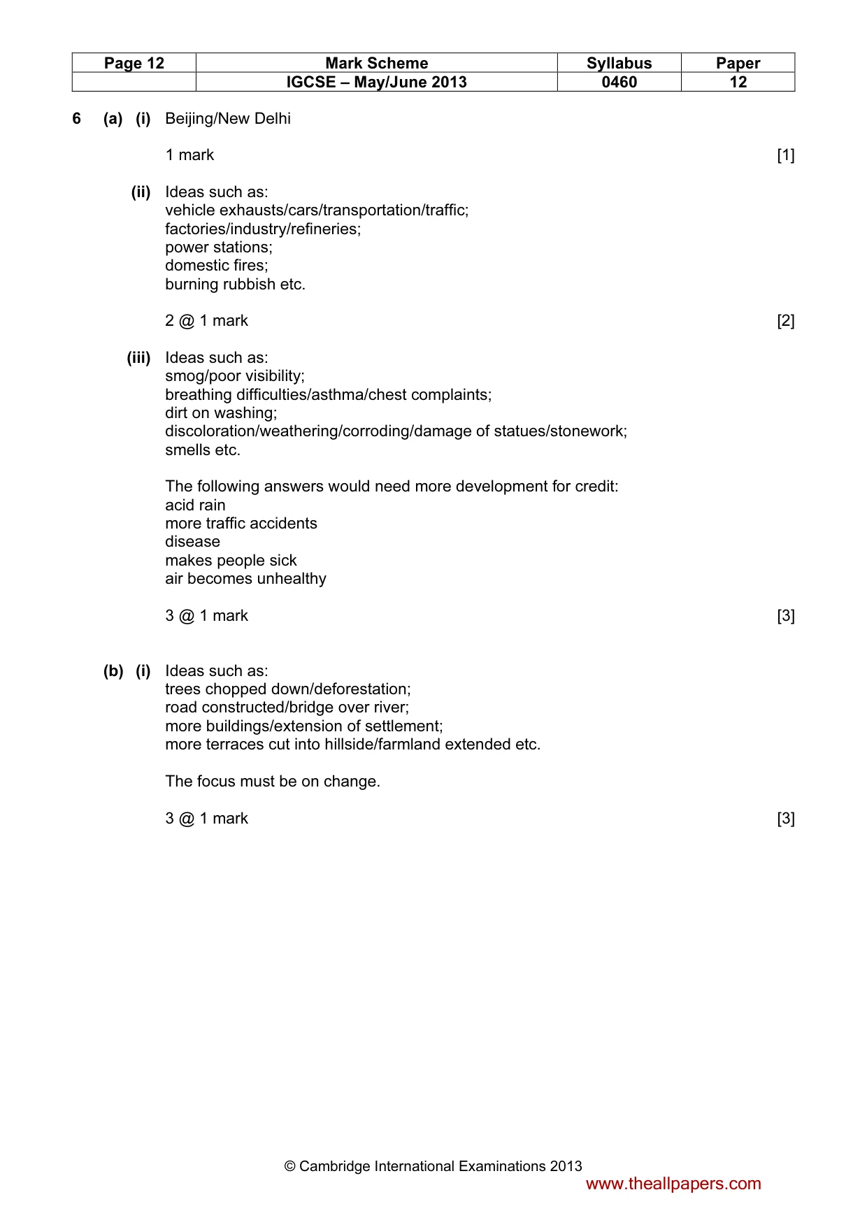
Page 12 Mark Scheme Syllabus Paper IGCSE – May/June 2013 0460 12 © Cambridge International Examinations 2013 6 (a) (i) Beijing/New Delhi 1 mark [1] (ii) Ideas such as: vehicle exhausts/cars/transportation/traffic; factories/industry/refineries; power stations; domestic fires; burning rubbish etc. 2 @ 1 mark [2] (iii) Ideas such as: smog/poor visibility; breathing difficulties/asthma/chest complaints; dirt on washing; discoloration/weathering/corroding/damage of statues/stonework; smells etc. The following answers would need more development for credit: acid rain more traffic accidents disease makes people sick air becomes unhealthy 3 @ 1 mark [3] (b) (i) Ideas such as: trees chopped down/deforestation; road constructed/bridge over river; more buildings/extension of settlement; more terraces cut into hillside/farmland extended etc. The focus must be on change. 3 @ 1 mark [3] www.theallpapers.com
Mark scheme, page 13
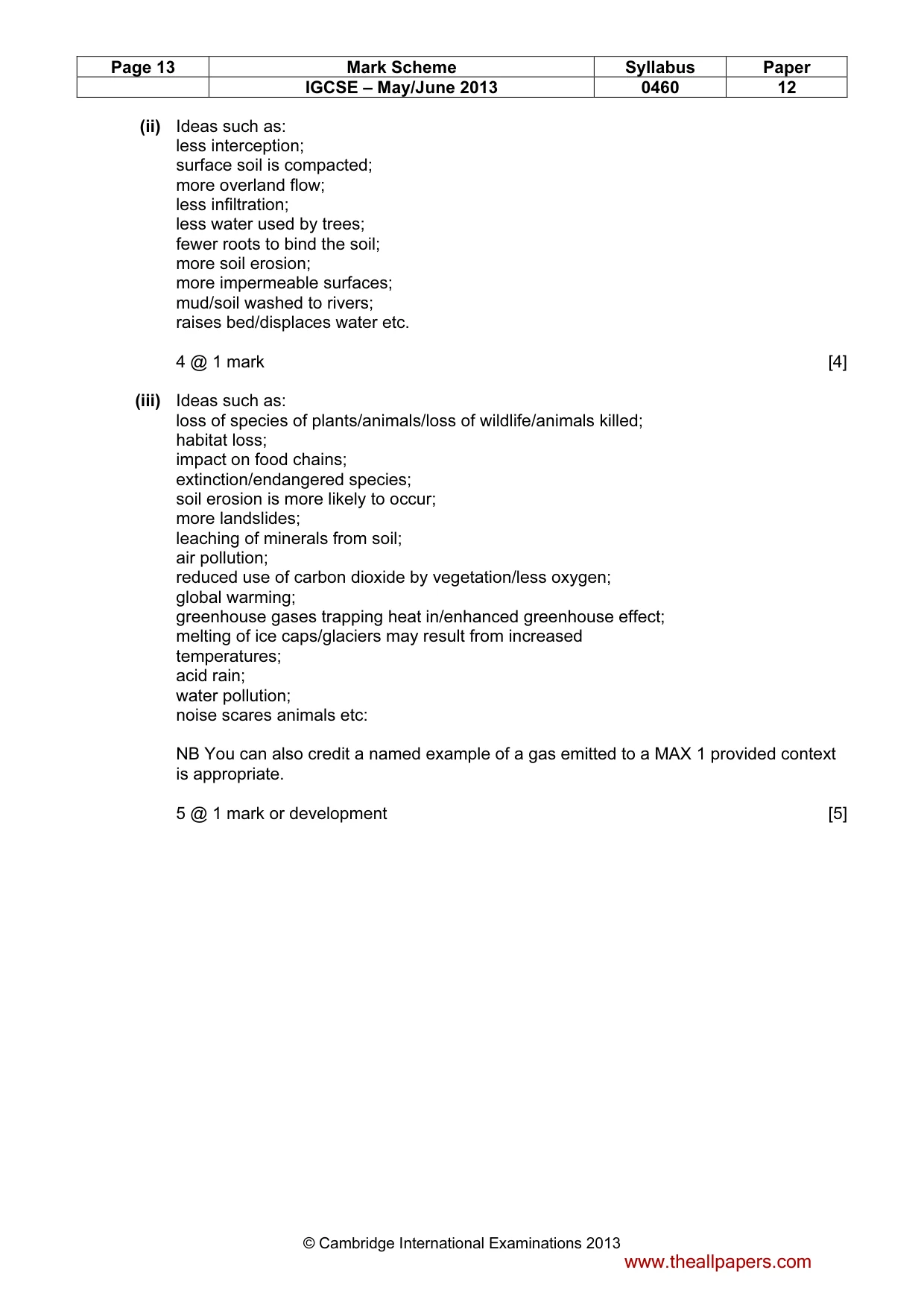
Page 13 Mark Scheme Syllabus Paper IGCSE – May/June 2013 0460 12 © Cambridge International Examinations 2013 (ii) Ideas such as: less interception; surface soil is compacted; more overland flow; less infiltration; less water used by trees; fewer roots to bind the soil; more soil erosion; more impermeable surfaces; mud/soil washed to rivers; raises bed/displaces water etc. 4 @ 1 mark [4] (iii) Ideas such as: loss of species of plants/animals/loss of wildlife/animals killed; habitat loss; impact on food chains; extinction/endangered species; soil erosion is more likely to occur; more landslides; leaching of minerals from soil; air pollution; reduced use of carbon dioxide by vegetation/less oxygen; global warming; greenhouse gases trapping heat in/enhanced greenhouse effect; melting of ice caps/glaciers may result from increased temperatures; acid rain; water pollution; noise scares animals etc: NB You can also credit a named example of a gas emitted to a MAX 1 provided context is appropriate. 5 @ 1 mark or development [5] www.theallpapers.com
Mark scheme, page 14
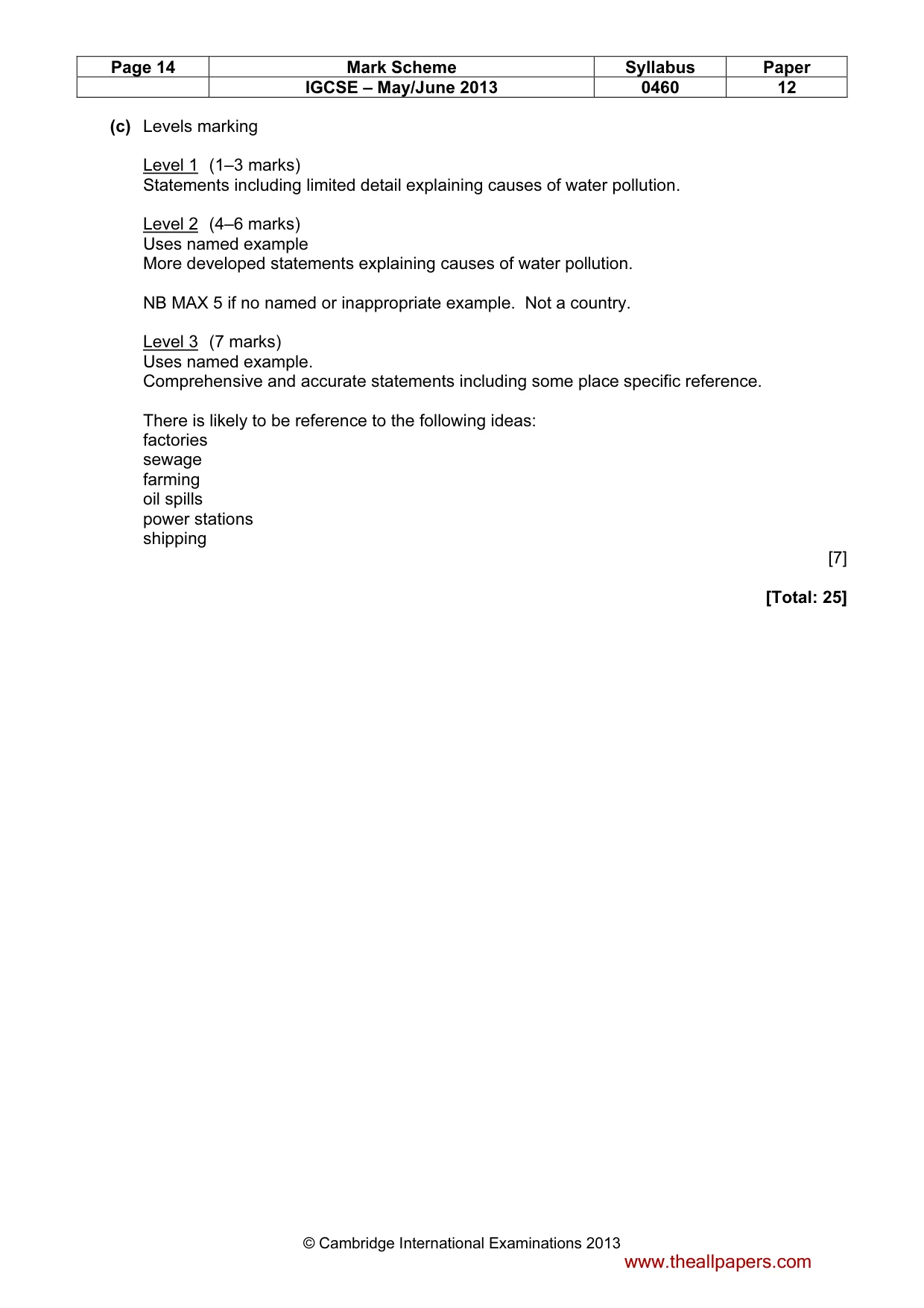
Page 14 Mark Scheme Syllabus Paper IGCSE – May/June 2013 0460 12 © Cambridge International Examinations 2013 (c) Levels marking Level 1 (1–3 marks) Statements including limited detail explaining causes of water pollution. Level 2 (4–6 marks) Uses named example More developed statements explaining causes of water pollution. NB MAX 5 if no named or inappropriate example. Not a country. Level 3 (7 marks) Uses named example. Comprehensive and accurate statements including some place specific reference. There is likely to be reference to the following ideas: factories sewage farming oil spills power stations shipping [7] [Total: 25] www.theallpapers.com
What you needed in this session
Cambridge’s own grade thresholds for 2013 May/June, Paper 1 · Variant 2. A higher threshold means an easier paper — the bar moves with how the cohort did.