Cambridge A Level Environmental Management (AS only) 8291 — 2017 Oct/Nov Paper 1 · Variant 2
8291/12/O/N/17 · 80 marks · ≈90 min
The question paper and its mark scheme, free to read here and free to download. This is Cambridge’s own paper, exactly as it was sat.
Question paper12 pages
Mark scheme14 pages
Answers below. Sit the paper first if you are practising.
Paper as text
Question paper, page 1
* 4 2 3 1 5 3 6 2 9 7 * This document consists of 11 printed pages and 1 blank page. DC (RW/AR) 135021/2 © UCLES 2017 [Turn over Cambridge International Examinations Cambridge International Advanced Subsidiary Level ENVIRONMENTAL MANAGEMENT 8291/12 Paper 1 Lithosphere and Atmosphere October/November 2017 1 hour 30 minutes Additional Materials: Answer Booklet/Paper READ THESE INSTRUCTIONS FIRST Write your Centre number, candidate number and name on all the work you hand in. Write in dark blue or black pen. You may use an HB pencil for any diagrams or graphs. Do not use staples, paper clips, glue or correction fluid. DO NOT WRITE IN ANY BARCODES. Electronic calculators may be used. You may lose marks if you do not show your working or if you do not use appropriate units. Section A Answer all questions in this section. Write your answers in the spaces provided on the question paper. Section B Answer one question from this section. Write your answers on the separate answer paper provided. At the end of the examination, 1. fasten all separate answer paper securely to the question paper; 2. enter the question number from Section B in the grid. For Examiner’s Use Section A 1 2 Section B Total
Question paper, page 2
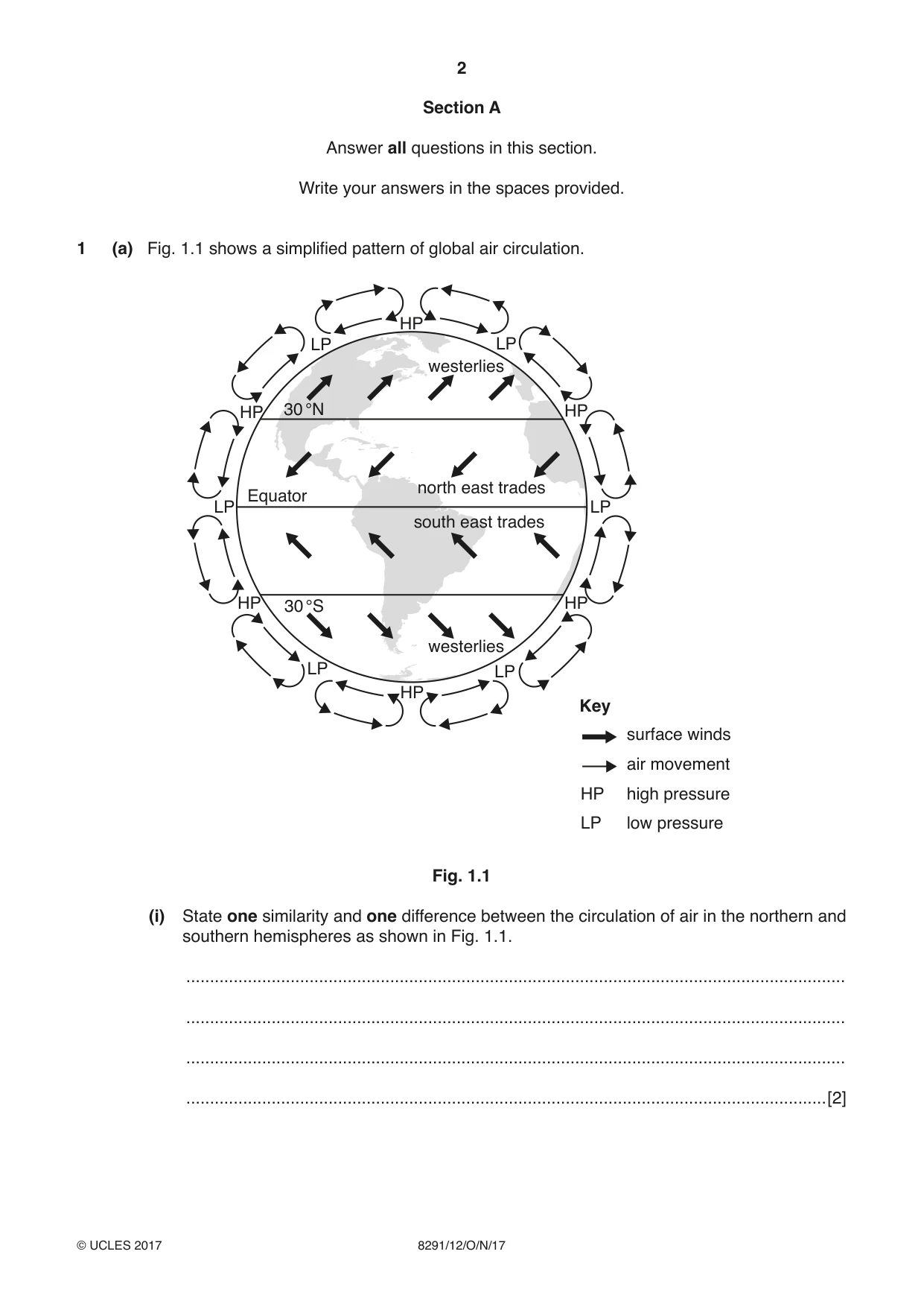
2 8291/12/O/N/17 © UCLES 2017 Section A Answer all questions in this section. Write your answers in the spaces provided. 1 (a) Fig. 1.1 shows a simplified pattern of global air circulation. Key surface winds air movement high pressure low pressure LP LP LP LP LP LP HP HP HP HP HP HP HP LP 30 °N 30 °S Equator westerlies westerlies north east trades south east trades Fig. 1.1 (i) State one similarity and one difference between the circulation of air in the northern and southern hemispheres as shown in Fig. 1.1. … … … …[2]
Question paper, page 3
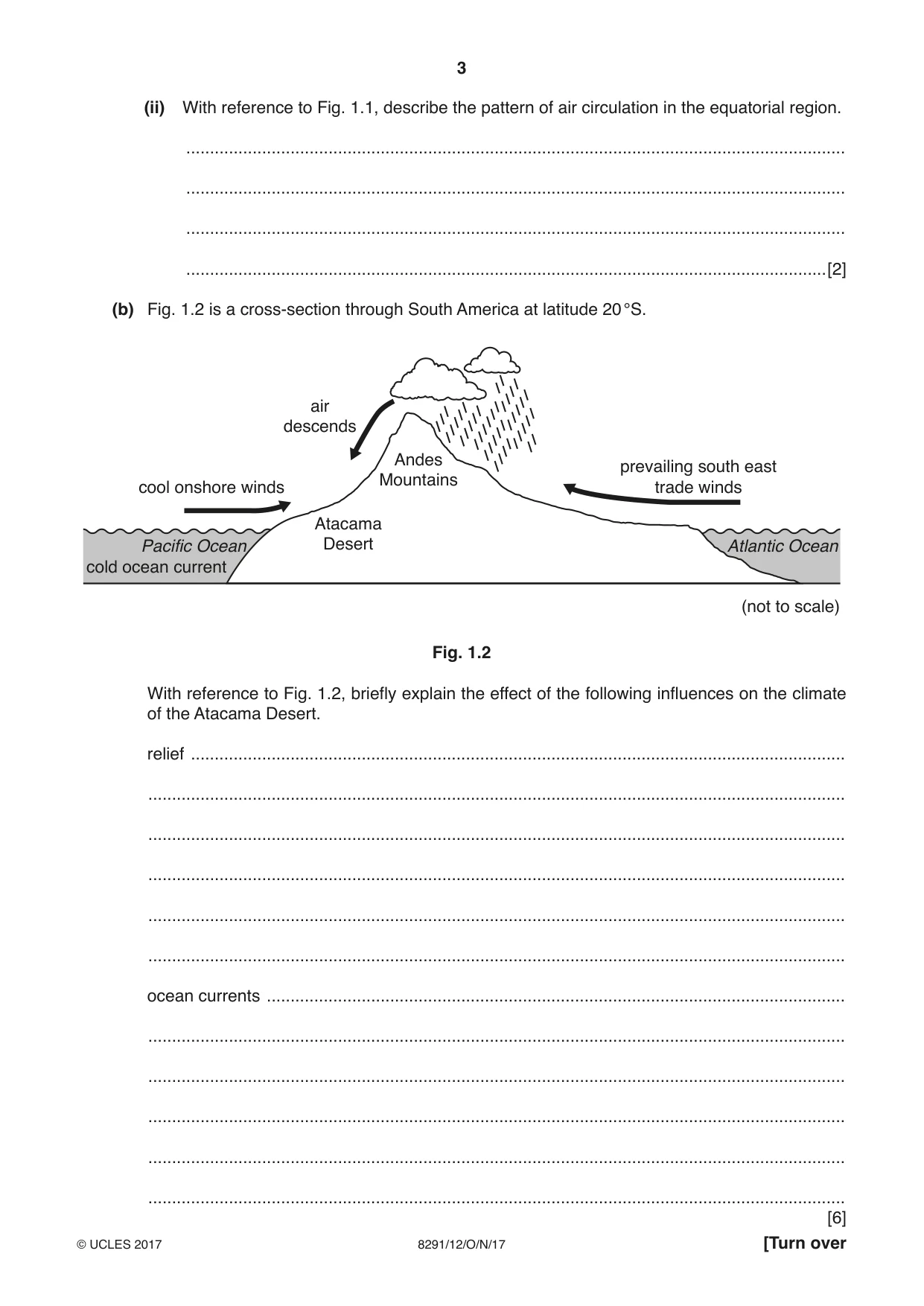
3 8291/12/O/N/17 © UCLES 2017 [Turn over (ii) With reference to Fig. 1.1, describe the pattern of air circulation in the equatorial region. … … … …[2] (b) Fig. 1.2 is a cross-section through South America at latitude 20 °S. cool onshore winds air descends prevailing south east trade winds Atacama Desert Pacific Ocean cold ocean current Atlantic Ocean Andes Mountains (not to scale) Fig. 1.2 With reference to Fig. 1.2, briefly explain the effect of the following influences on the climate of the Atacama Desert. relief … … … … … … ocean currents … … … … … … [6]
Question paper, page 4
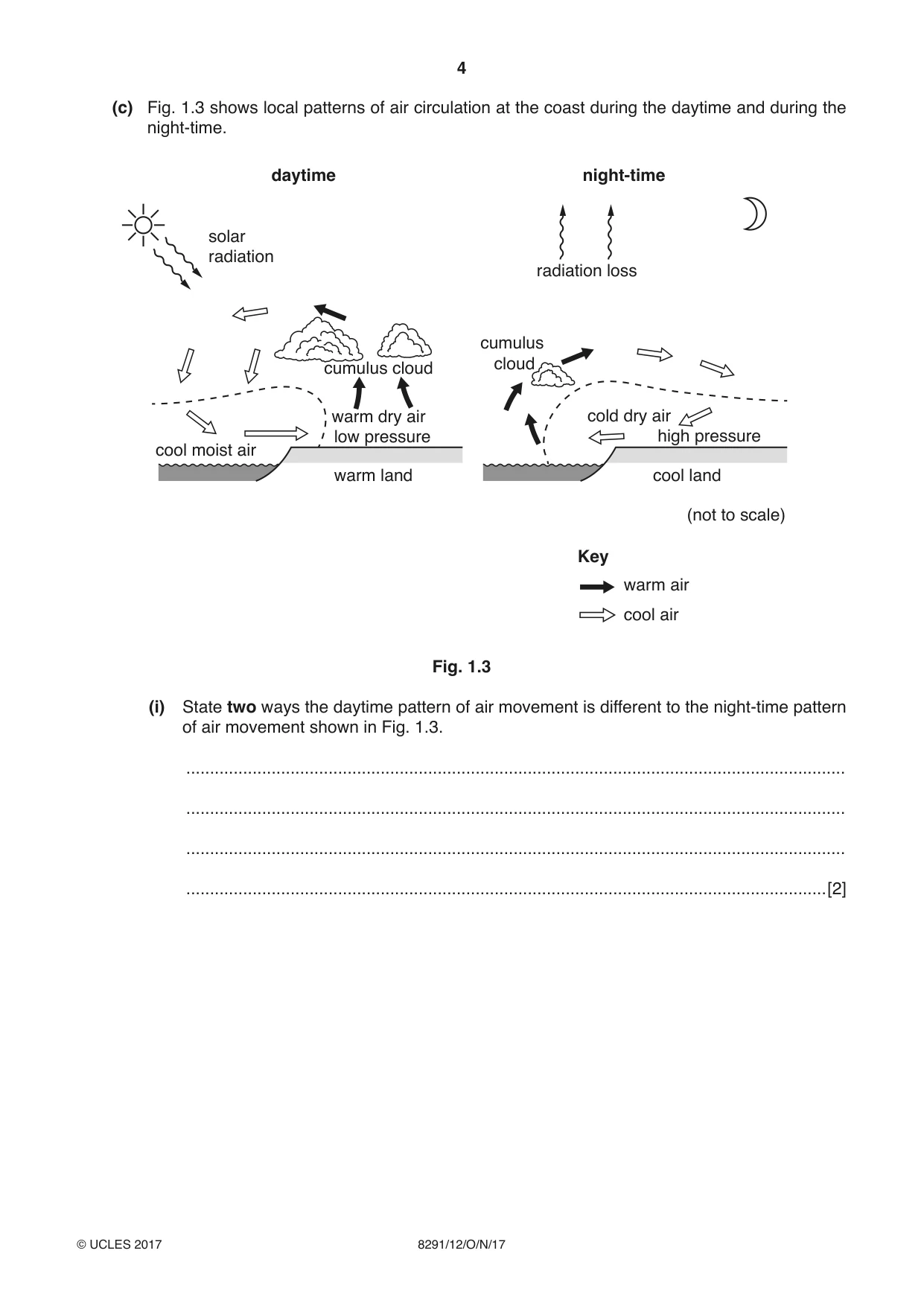
4 8291/12/O/N/17 © UCLES 2017 (c) Fig. 1.3 shows local patterns of air circulation at the coast during the daytime and during the night-time. cumulus cloud cumulus cloud daytime night-time solar radiation radiation loss cool moist air low pressure warm land Key warm air cool air warm dry air cool land cold dry air high pressure (not to scale) Fig. 1.3 (i) State two ways the daytime pattern of air movement is different to the night-time pattern of air movement shown in Fig. 1.3. … … … …[2]
Question paper, page 5
5 8291/12/O/N/17 © UCLES 2017 [Turn over (ii) Explain why clouds are more common along the coast during the daytime than during the night-time. … … … … … … … …[4] (d) Explain why daily forecasts of wind speed are useful. … … … … … … … …[4] [Total: 20]
Question paper, page 6
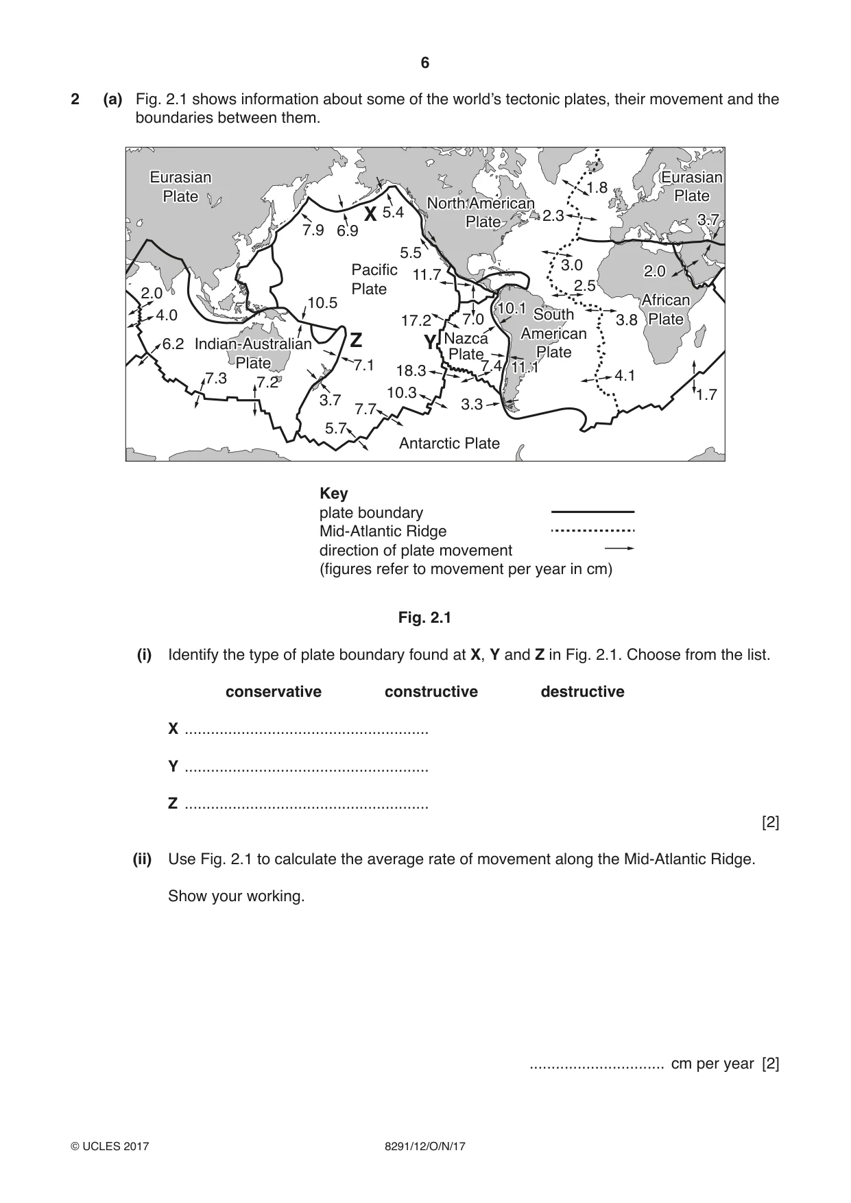
6 8291/12/O/N/17 © UCLES 2017 2 (a) Fig. 2.1 shows information about some of the world’s tectonic plates, their movement and the boundaries between them. Key plate boundary Mid-Atlantic Ridge direction of plate movement (figures refer to movement per year in cm) Indian-Australian Plate North American Plate 10.1 11.1 2.0 African Plate Eurasian Plate Eurasian Plate 3.7 South American Plate 2.0 4.0 6.2 7.3 7.2 3.7 5.7 7.7 7.1 7.0 Z Y 10.5 7.9 6.9 X 5.4 5.5 11.7 Pacific Plate Indian-Australian Plate 17.2 18.3 10.3 Nazca Plate 3.3 Antarctic Plate 7.4 North American Plate 2.3 1.8 3.0 10.1 11.1 2.5 3.8 4.1 2.0 African Plate Eurasian Plate Eurasian Plate 3.7 1.7 South American Plate Fig. 2.1 (i) Identify the type of plate boundary found at X, Y and Z in Fig. 2.1. Choose from the list. conservative constructive destructive X … Y … Z … [2] (ii) Use Fig. 2.1 to calculate the average rate of movement along the Mid-Atlantic Ridge. Show your working. … cm per year [2]
Question paper, page 7
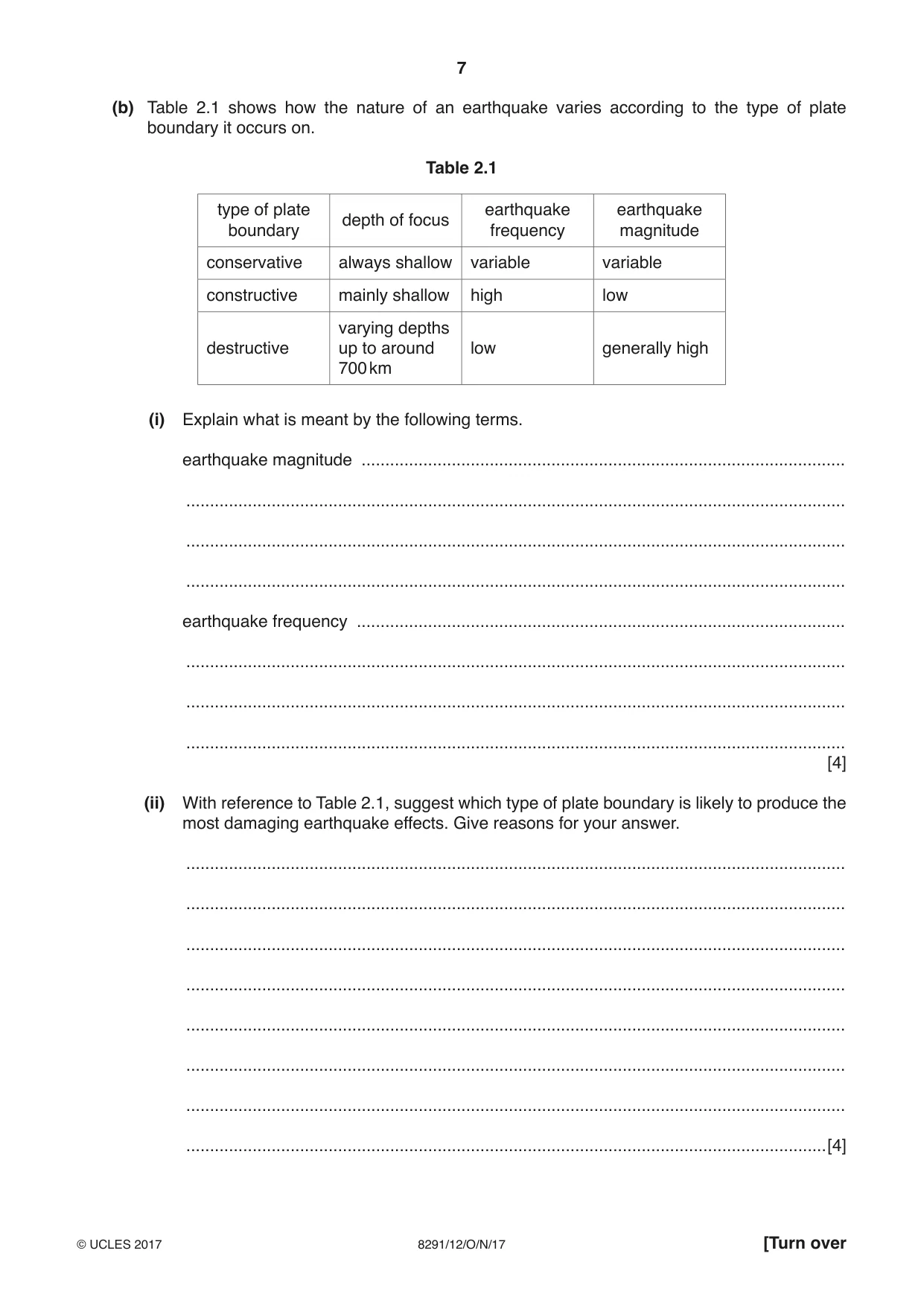
7 8291/12/O/N/17 © UCLES 2017 [Turn over (b) Table 2.1 shows how the nature of an earthquake varies according to the type of plate boundary it occurs on. Table 2.1 type of plate boundary depth of focus earthquake frequency earthquake magnitude conservative always shallow variable variable constructive mainly shallow high low destructive varying depths up to around 700 km low generally high (i) Explain what is meant by the following terms. earthquake magnitude … … … … earthquake frequency … … … … [4] (ii) With reference to Table 2.1, suggest which type of plate boundary is likely to produce the most damaging earthquake effects. Give reasons for your answer. … … … … … … … …[4]
Question paper, page 8
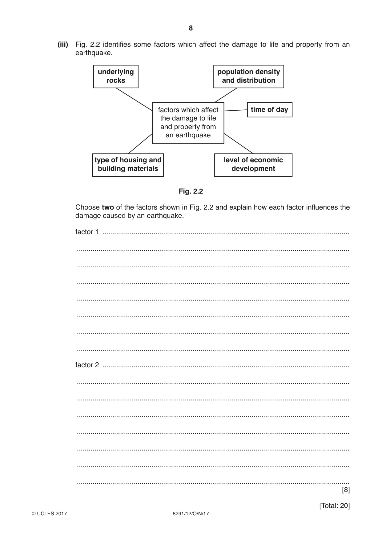
8 8291/12/O/N/17 © UCLES 2017 (iii) Fig. 2.2 identifies some factors which affect the damage to life and property from an earthquake. underlying rocks population density and distribution factors which affect the damage to life and property from an earthquake type of housing and building materials time of day level of economic development Fig. 2.2 Choose two of the factors shown in Fig. 2.2 and explain how each factor influences the damage caused by an earthquake. factor 1 … … … … … … … … factor 2 … … … … … … … … [8] [Total: 20]
Question paper, page 9
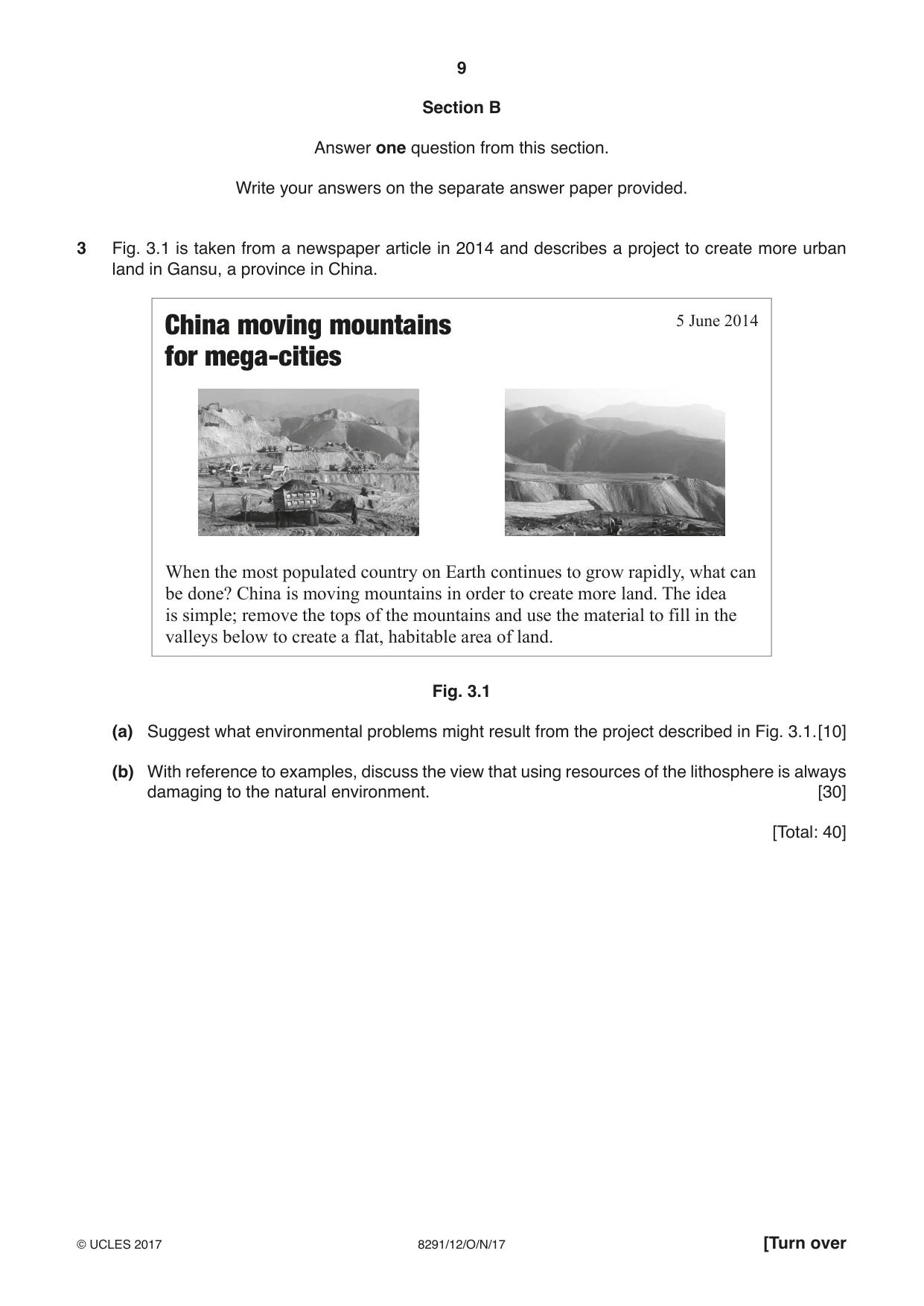
9 8291/12/O/N/17 © UCLES 2017 [Turn over Section B Answer one question from this section. Write your answers on the separate answer paper provided. 3 Fig. 3.1 is taken from a newspaper article in 2014 and describes a project to create more urban land in Gansu, a province in China. China moving mountains for mega-cities 5 June 2014 When the most populated country on Earth continues to grow rapidly, what can be done? China is moving mountains in order to create more land. The idea is simple; remove the tops of the mountains and use the material to fill in the valleys below to create a flat, habitable area of land. Fig. 3.1 (a) Suggest what environmental problems might result from the project described in Fig. 3.1. [10] (b) With reference to examples, discuss the view that using resources of the lithosphere is always damaging to the natural environment. [30] [Total: 40]
Question paper, page 10
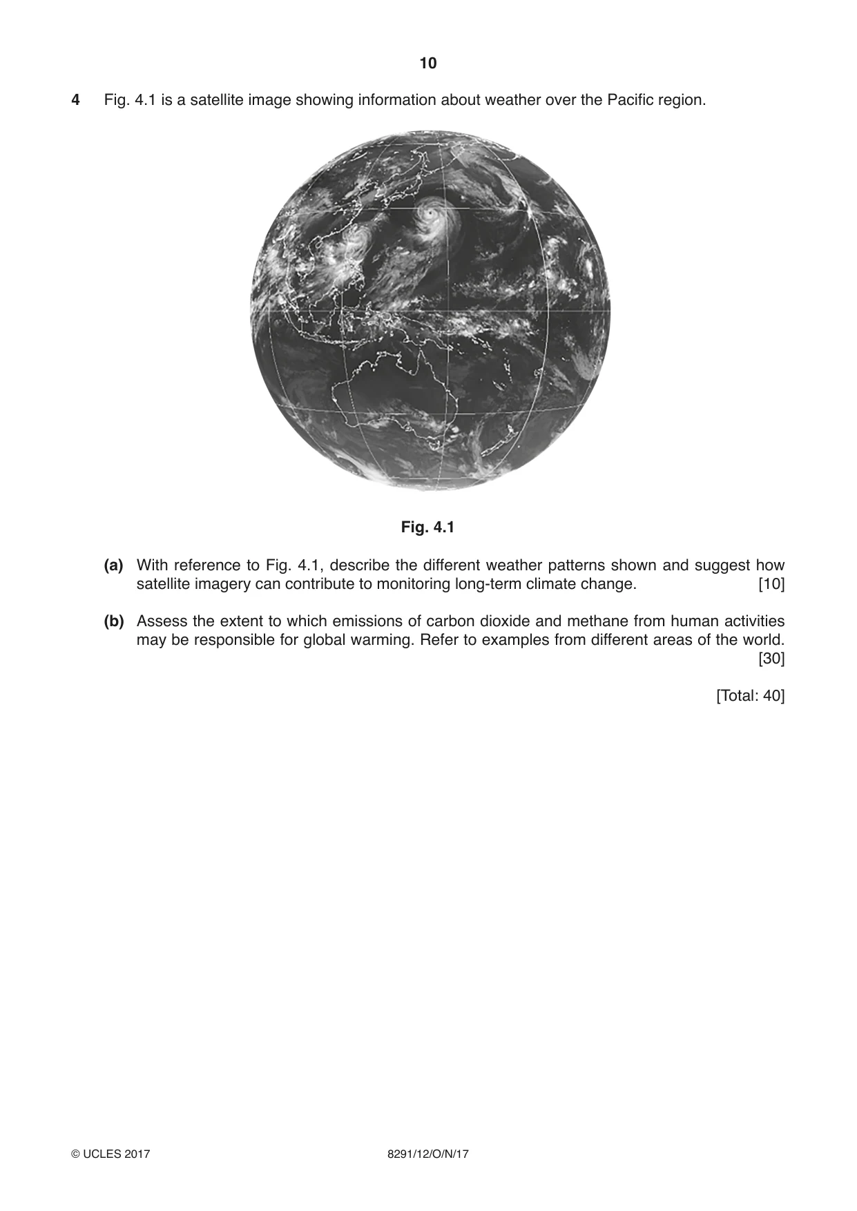
10 8291/12/O/N/17 © UCLES 2017 4 Fig. 4.1 is a satellite image showing information about weather over the Pacific region. Fig. 4.1 (a) With reference to Fig. 4.1, describe the different weather patterns shown and suggest how satellite imagery can contribute to monitoring long-term climate change. [10] (b) Assess the extent to which emissions of carbon dioxide and methane from human activities may be responsible for global warming. Refer to examples from different areas of the world. [30] [Total: 40]
Question paper, page 11
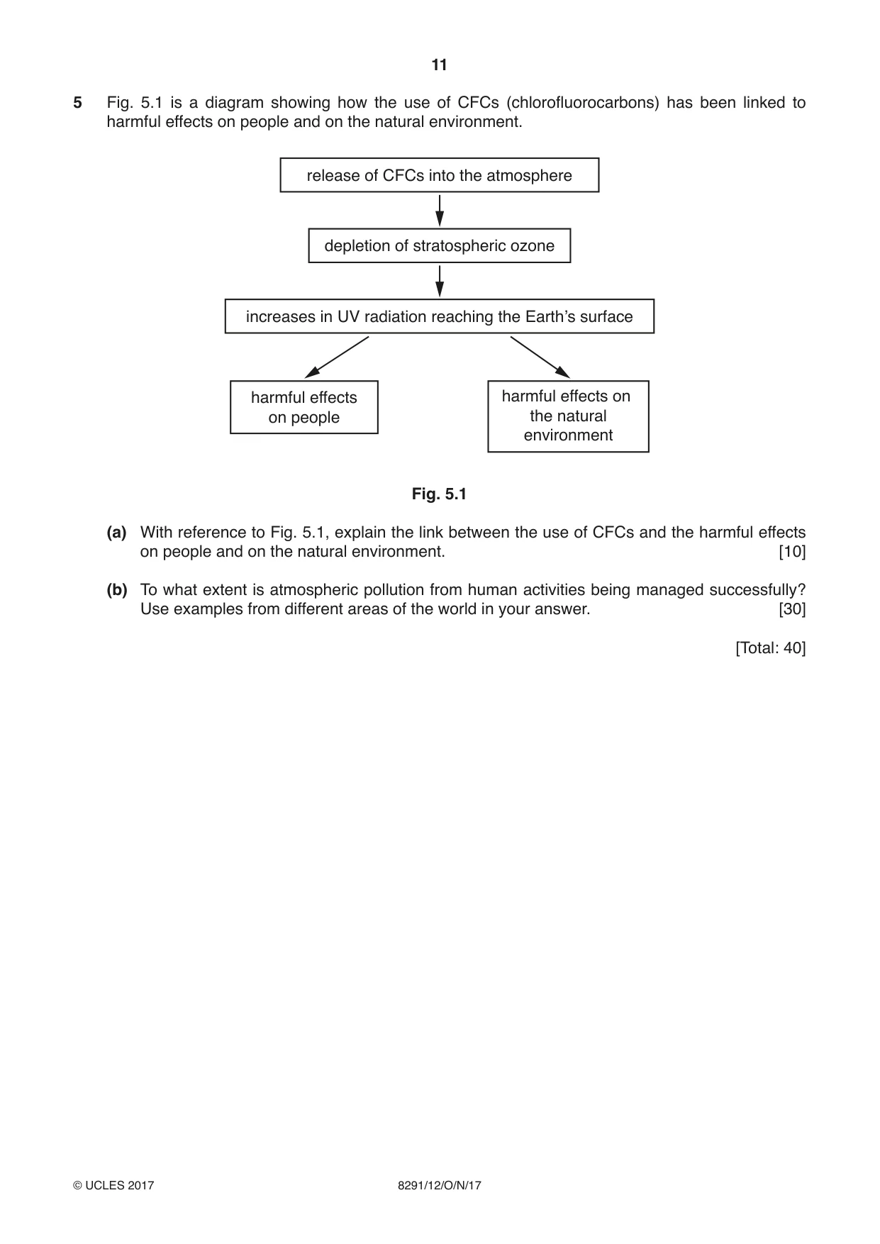
11 8291/12/O/N/17 © UCLES 2017 5 Fig. 5.1 is a diagram showing how the use of CFCs (chlorofluorocarbons) has been linked to harmful effects on people and on the natural environment. release of CFCs into the atmosphere depletion of stratospheric ozone increases in UV radiation reaching the Earth’s surface harmful effects on people harmful effects on the natural environment Fig. 5.1 (a) With reference to Fig. 5.1, explain the link between the use of CFCs and the harmful effects on people and on the natural environment. [10] (b) To what extent is atmospheric pollution from human activities being managed successfully? Use examples from different areas of the world in your answer. [30] [Total: 40]
Question paper, page 12
12 8291/12/O/N/17 © UCLES 2017 Permission to reproduce items where third-party owned material protected by copyright is included has been sought and cleared where possible. Every reasonable effort has been made by the publisher (UCLES) to trace copyright holders, but if any items requiring clearance have unwittingly been included, the publisher will be pleased to make amends at the earliest possible opportunity. To avoid the issue of disclosure of answer-related information to candidates, all copyright acknowledgements are reproduced online in the Cambridge International Examinations Copyright Acknowledgements Booklet. This is produced for each series of examinations and is freely available to download at www.cie.org.uk after the live examination series. Cambridge International Examinations is part of the Cambridge Assessment Group. Cambridge Assessment is the brand name of University of Cambridge Local Examinations Syndicate (UCLES), which is itself a department of the University of Cambridge. BLANK PAGE
Mark scheme, page 1
® IGCSE is a registered trademark. This document consists of 14 printed pages. © UCLES 2017 [Turn over Cambridge Assessment International Education Cambridge International Advanced Subsidiary Level ENVIRONMENTAL MANAGEMENT 8291/12 Paper 1 October/November 2017 MARK SCHEME Maximum Mark: 80 Published This mark scheme is published as an aid to teachers and candidates, to indicate the requirements of the examination. It shows the basis on which Examiners were instructed to award marks. It does not indicate the details of the discussions that took place at an Examiners’ meeting before marking began, which would have considered the acceptability of alternative answers. Mark schemes should be read in conjunction with the question paper and the Principal Examiner Report for Teachers. Cambridge International will not enter into discussions about these mark schemes. Cambridge International is publishing the mark schemes for the October/November 2017 series for most Cambridge IGCSE®, Cambridge International A and AS Level components and some Cambridge O Level components.
Mark scheme, page 2
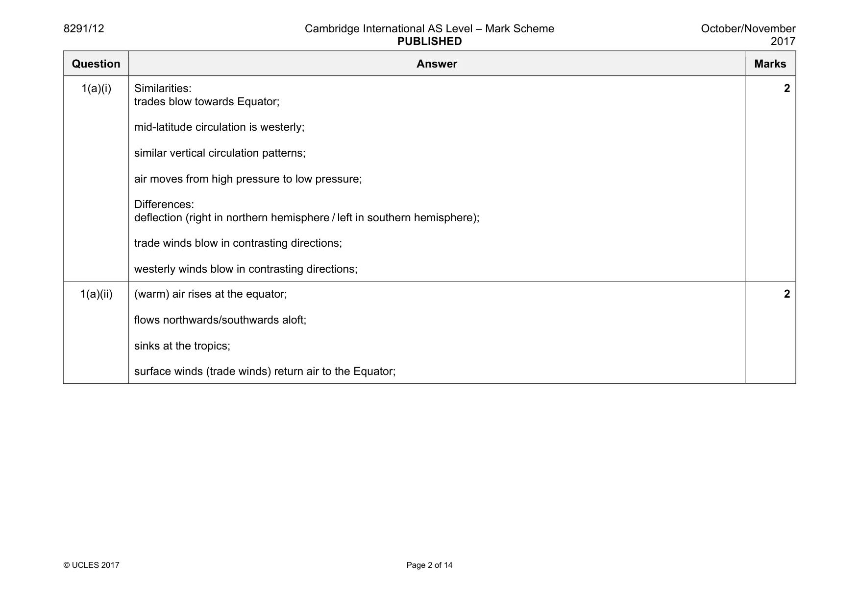
8291/12 Cambridge International AS Level – Mark Scheme PUBLISHED October/November 2017 © UCLES 2017 Page 2 of 14 Question Answer Marks 1(a)(i) Similarities: trades blow towards Equator; mid-latitude circulation is westerly; similar vertical circulation patterns; air moves from high pressure to low pressure; Differences: deflection (right in northern hemisphere / left in southern hemisphere); trade winds blow in contrasting directions; westerly winds blow in contrasting directions; 2 1(a)(ii) (warm) air rises at the equator; flows northwards/southwards aloft; sinks at the tropics; surface winds (trade winds) return air to the Equator; 2
Mark scheme, page 3
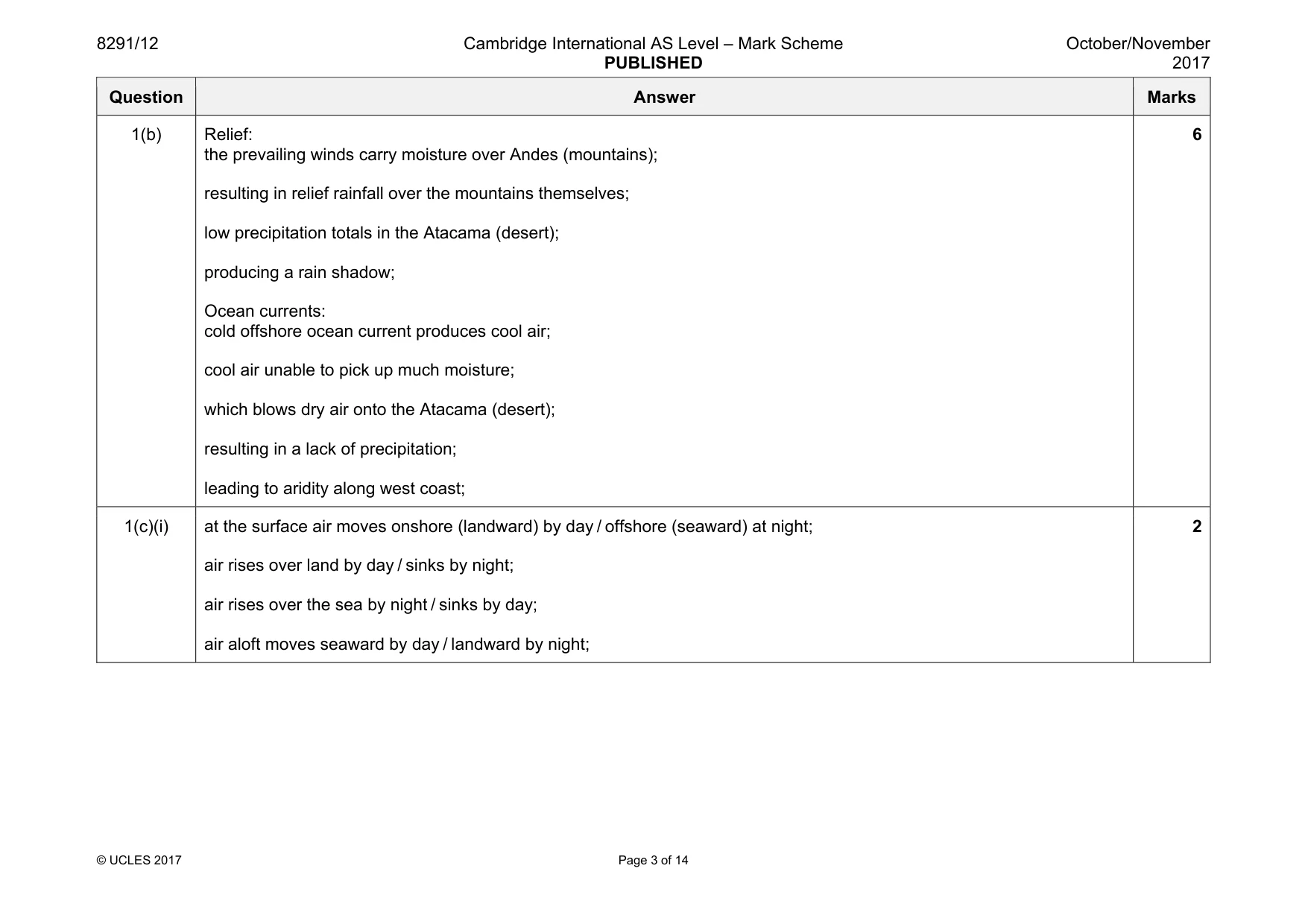
8291/12 Cambridge International AS Level – Mark Scheme PUBLISHED October/November 2017 © UCLES 2017 Page 3 of 14 Question Answer Marks 1(b) Relief: the prevailing winds carry moisture over Andes (mountains); resulting in relief rainfall over the mountains themselves; low precipitation totals in the Atacama (desert); producing a rain shadow; Ocean currents: cold offshore ocean current produces cool air; cool air unable to pick up much moisture; which blows dry air onto the Atacama (desert); resulting in a lack of precipitation; leading to aridity along west coast; 6 1(c)(i) at the surface air moves onshore (landward) by day / offshore (seaward) at night; air rises over land by day / sinks by night; air rises over the sea by night / sinks by day; air aloft moves seaward by day / landward by night; 2
Mark scheme, page 4
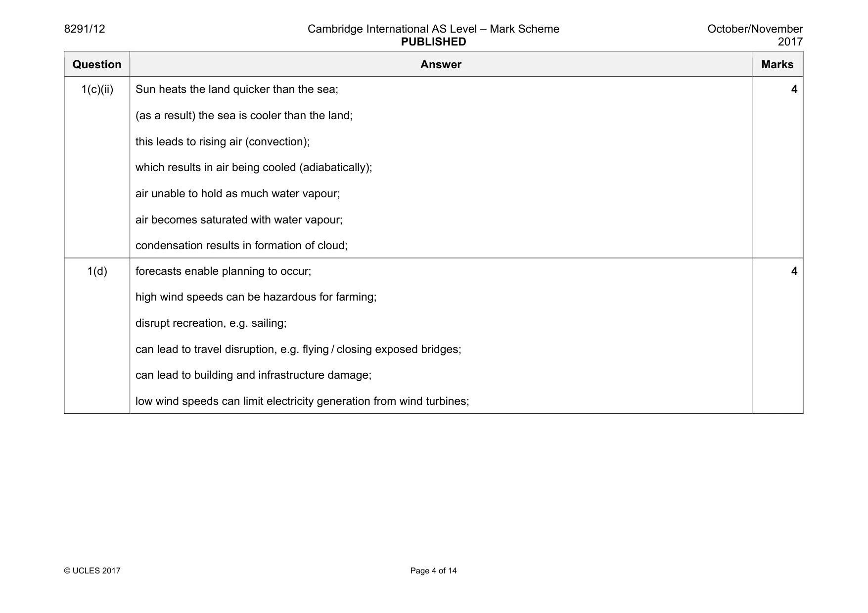
8291/12 Cambridge International AS Level – Mark Scheme PUBLISHED October/November 2017 © UCLES 2017 Page 4 of 14 Question Answer Marks 1(c)(ii) Sun heats the land quicker than the sea; (as a result) the sea is cooler than the land; this leads to rising air (convection); which results in air being cooled (adiabatically); air unable to hold as much water vapour; air becomes saturated with water vapour; condensation results in formation of cloud; 4 1(d) forecasts enable planning to occur; high wind speeds can be hazardous for farming; disrupt recreation, e.g. sailing; can lead to travel disruption, e.g. flying / closing exposed bridges; can lead to building and infrastructure damage; low wind speeds can limit electricity generation from wind turbines; 4
Mark scheme, page 5
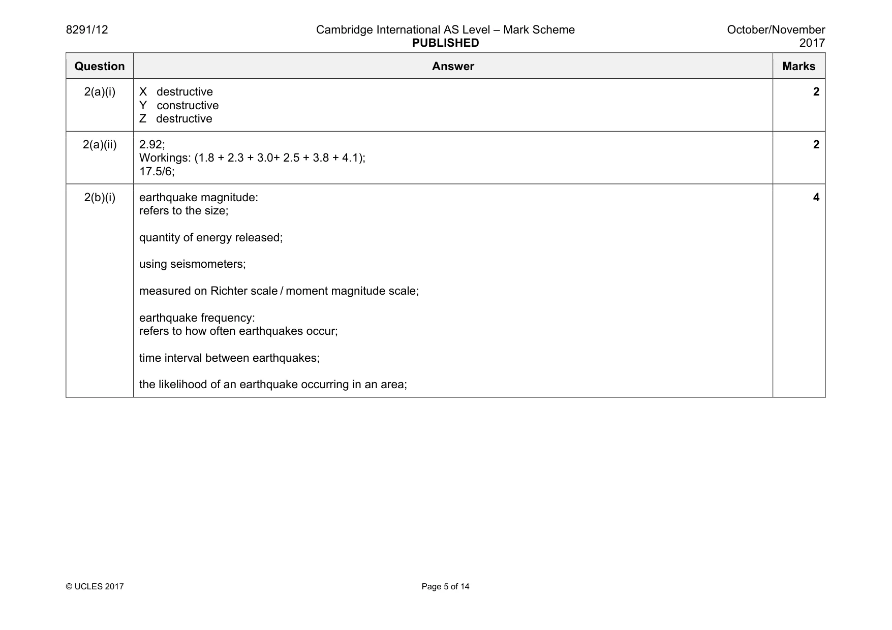
8291/12 Cambridge International AS Level – Mark Scheme PUBLISHED October/November 2017 © UCLES 2017 Page 5 of 14 Question Answer Marks 2(a)(i) X destructive Y constructive Z destructive 2 2(a)(ii) 2.92; Workings: (1.8 + 2.3 + 3.0+ 2.5 + 3.8 + 4.1); 17.5/6; 2 2(b)(i) earthquake magnitude: refers to the size; quantity of energy released; using seismometers; measured on Richter scale / moment magnitude scale; earthquake frequency: refers to how often earthquakes occur; time interval between earthquakes; the likelihood of an earthquake occurring in an area; 4
Mark scheme, page 6
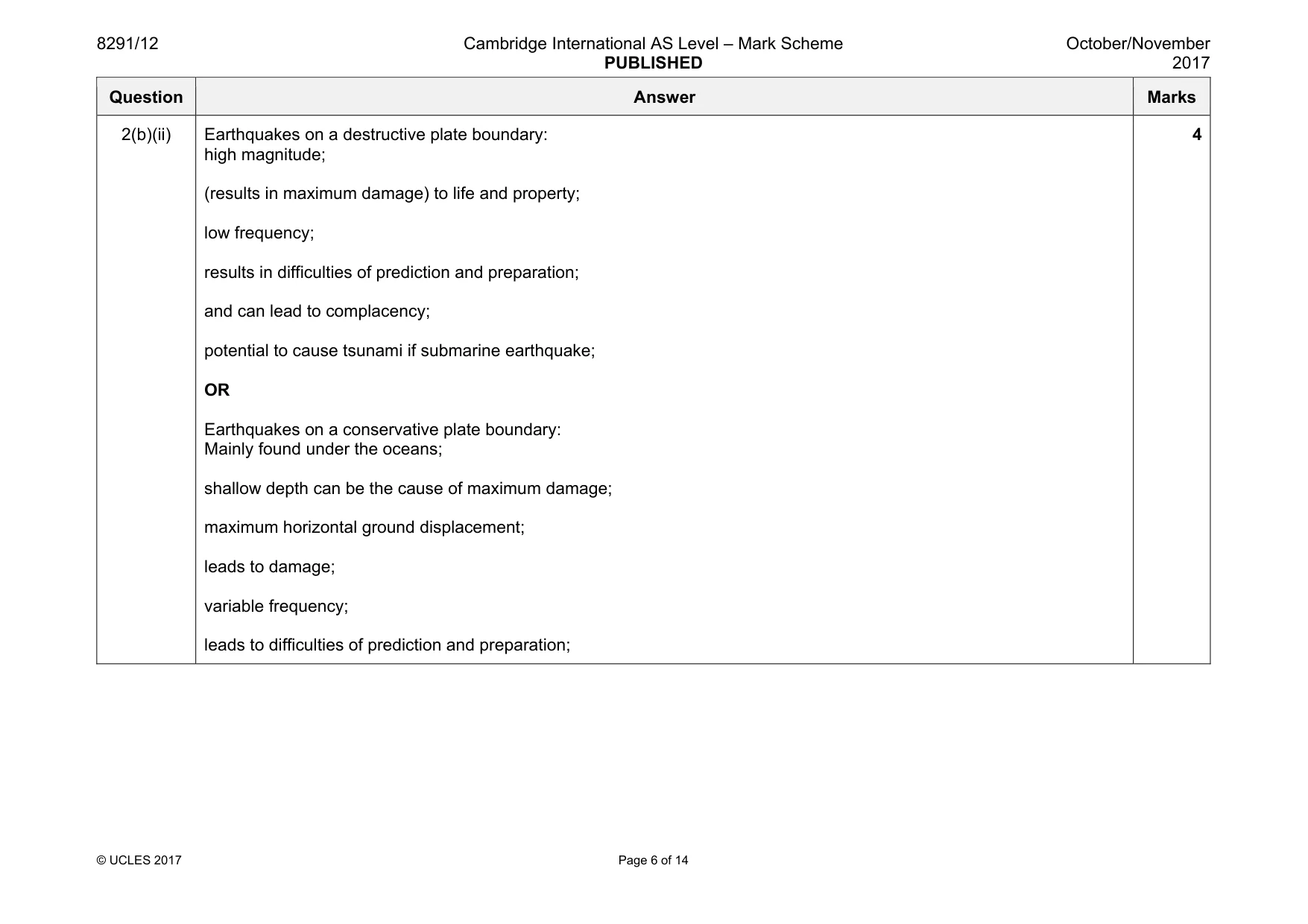
8291/12 Cambridge International AS Level – Mark Scheme PUBLISHED October/November 2017 © UCLES 2017 Page 6 of 14 Question Answer Marks 2(b)(ii) Earthquakes on a destructive plate boundary: high magnitude; (results in maximum damage) to life and property; low frequency; results in difficulties of prediction and preparation; and can lead to complacency; potential to cause tsunami if submarine earthquake; OR Earthquakes on a conservative plate boundary: Mainly found under the oceans; shallow depth can be the cause of maximum damage; maximum horizontal ground displacement; leads to damage; variable frequency; leads to difficulties of prediction and preparation; 4
Mark scheme, page 7
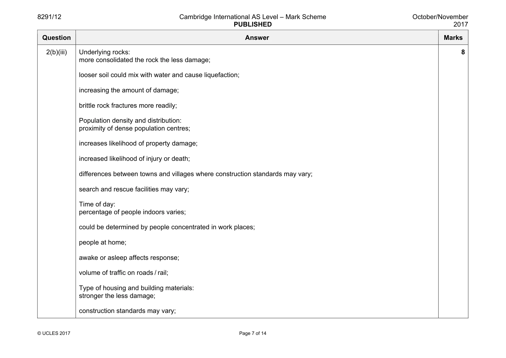
8291/12 Cambridge International AS Level – Mark Scheme PUBLISHED October/November 2017 © UCLES 2017 Page 7 of 14 Question Answer Marks 2(b)(iii) Underlying rocks: more consolidated the rock the less damage; looser soil could mix with water and cause liquefaction; increasing the amount of damage; brittle rock fractures more readily; Population density and distribution: proximity of dense population centres; increases likelihood of property damage; increased likelihood of injury or death; differences between towns and villages where construction standards may vary; search and rescue facilities may vary; Time of day: percentage of people indoors varies; could be determined by people concentrated in work places; people at home; awake or asleep affects response; volume of traffic on roads / rail; Type of housing and building materials: stronger the less damage; construction standards may vary; 8
Mark scheme, page 8
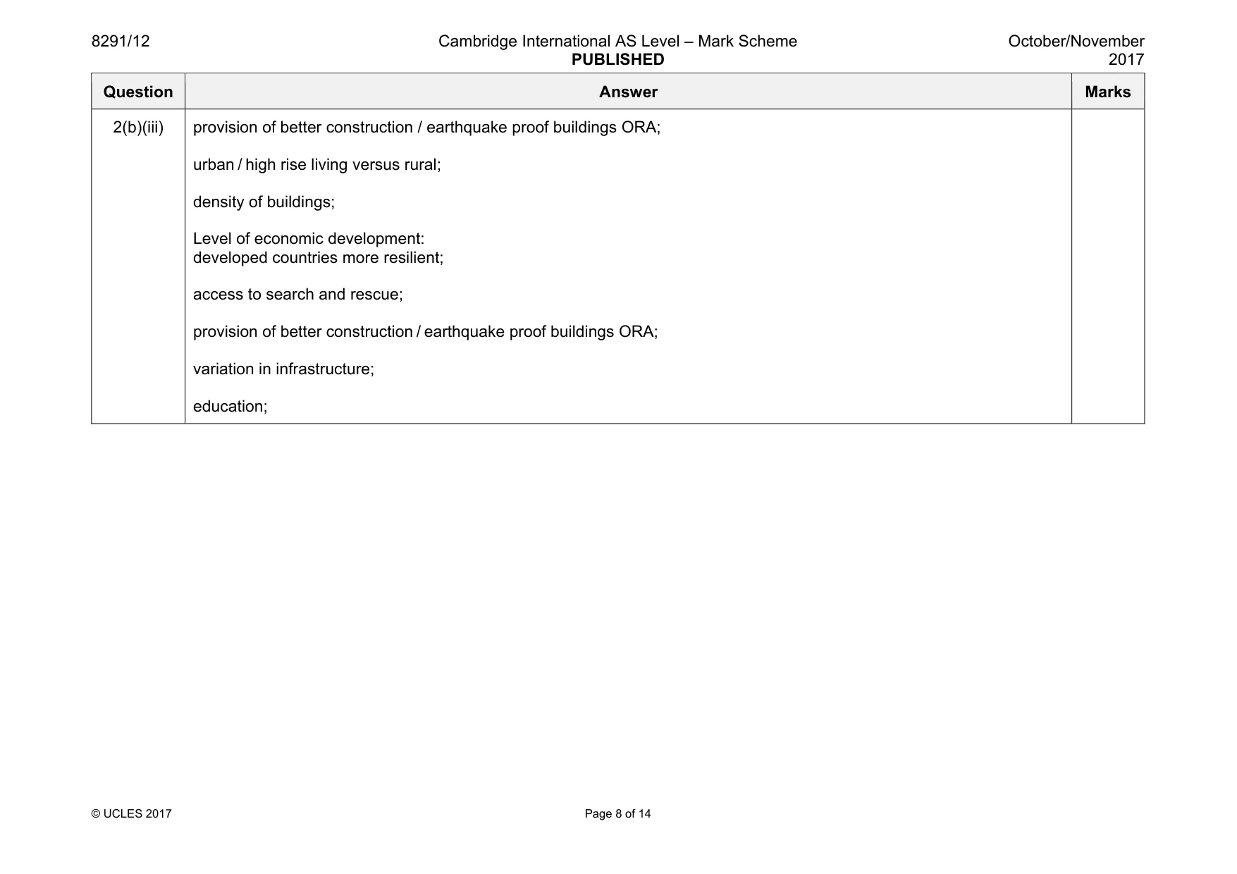
8291/12 Cambridge International AS Level – Mark Scheme PUBLISHED October/November 2017 © UCLES 2017 Page 8 of 14 Question Answer Marks 2(b)(iii) provision of better construction / earthquake proof buildings ORA; urban / high rise living versus rural; density of buildings; Level of economic development: developed countries more resilient; access to search and rescue; provision of better construction / earthquake proof buildings ORA; variation in infrastructure; education;
Mark scheme, page 9
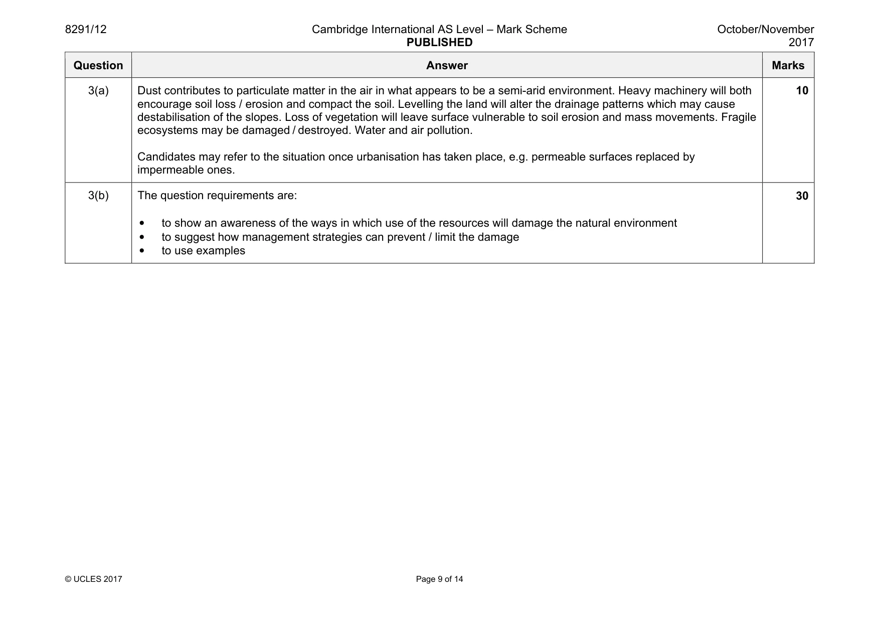
8291/12 Cambridge International AS Level – Mark Scheme PUBLISHED October/November 2017 © UCLES 2017 Page 9 of 14 Question Answer Marks 3(a) Dust contributes to particulate matter in the air in what appears to be a semi-arid environment. Heavy machinery will both encourage soil loss / erosion and compact the soil. Levelling the land will alter the drainage patterns which may cause destabilisation of the slopes. Loss of vegetation will leave surface vulnerable to soil erosion and mass movements. Fragile ecosystems may be damaged / destroyed. Water and air pollution. Candidates may refer to the situation once urbanisation has taken place, e.g. permeable surfaces replaced by impermeable ones. 10 3(b) The question requirements are: • to show an awareness of the ways in which use of the resources will damage the natural environment • to suggest how management strategies can prevent / limit the damage • to use examples 30
Mark scheme, page 10
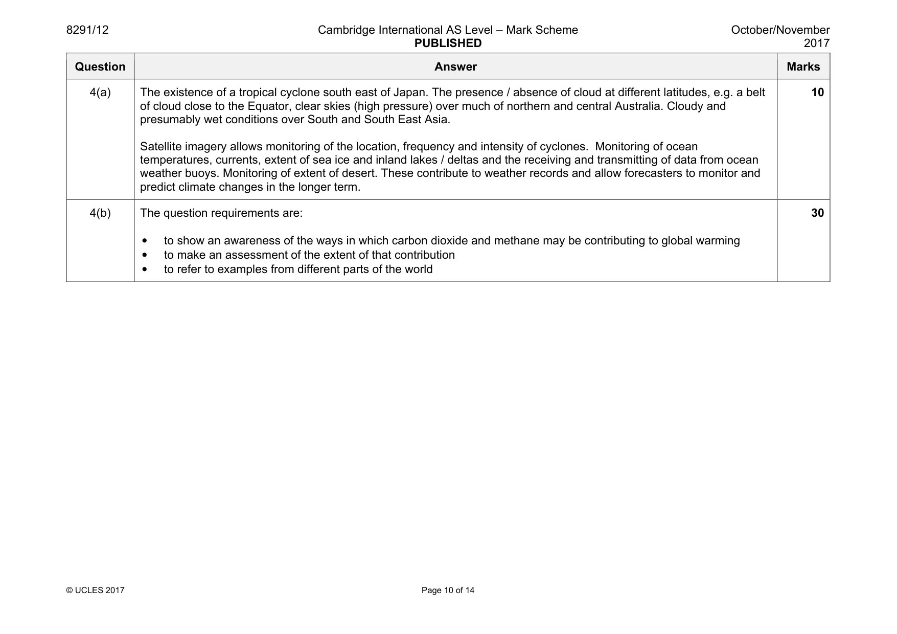
8291/12 Cambridge International AS Level – Mark Scheme PUBLISHED October/November 2017 © UCLES 2017 Page 10 of 14 Question Answer Marks 4(a) The existence of a tropical cyclone south east of Japan. The presence / absence of cloud at different latitudes, e.g. a belt of cloud close to the Equator, clear skies (high pressure) over much of northern and central Australia. Cloudy and presumably wet conditions over South and South East Asia. Satellite imagery allows monitoring of the location, frequency and intensity of cyclones. Monitoring of ocean temperatures, currents, extent of sea ice and inland lakes / deltas and the receiving and transmitting of data from ocean weather buoys. Monitoring of extent of desert. These contribute to weather records and allow forecasters to monitor and predict climate changes in the longer term. 10 4(b) The question requirements are: • to show an awareness of the ways in which carbon dioxide and methane may be contributing to global warming • to make an assessment of the extent of that contribution • to refer to examples from different parts of the world 30
Mark scheme, page 11
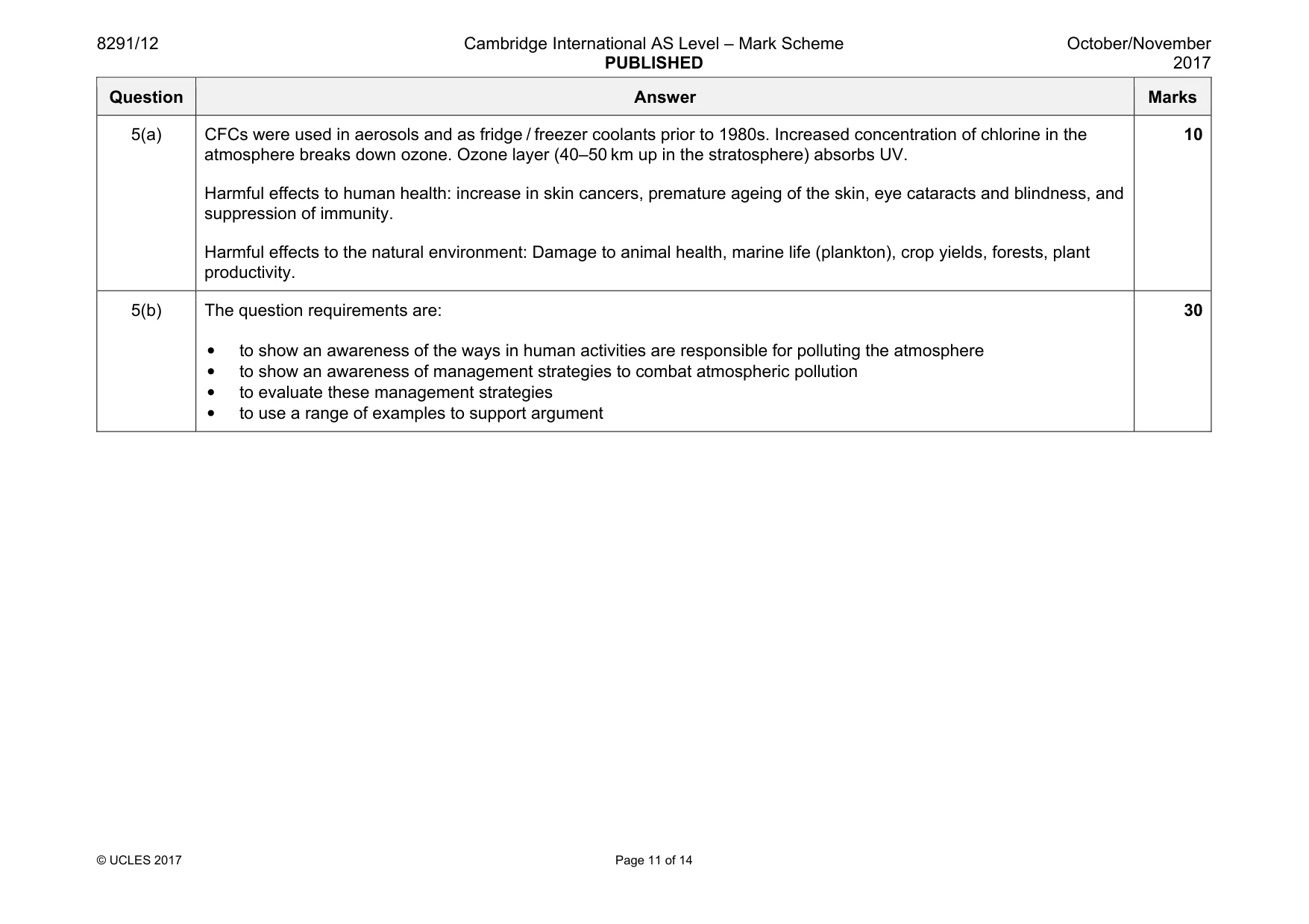
8291/12 Cambridge International AS Level – Mark Scheme PUBLISHED October/November 2017 © UCLES 2017 Page 11 of 14 Question Answer Marks 5(a) CFCs were used in aerosols and as fridge / freezer coolants prior to 1980s. Increased concentration of chlorine in the atmosphere breaks down ozone. Ozone layer (40–50 km up in the stratosphere) absorbs UV. Harmful effects to human health: increase in skin cancers, premature ageing of the skin, eye cataracts and blindness, and suppression of immunity. Harmful effects to the natural environment: Damage to animal health, marine life (plankton), crop yields, forests, plant productivity. 10 5(b) The question requirements are: • to show an awareness of the ways in human activities are responsible for polluting the atmosphere • to show an awareness of management strategies to combat atmospheric pollution • to evaluate these management strategies • to use a range of examples to support argument 30
Mark scheme, page 12
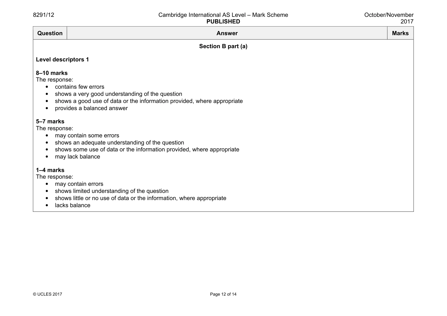
8291/12 Cambridge International AS Level – Mark Scheme PUBLISHED October/November 2017 © UCLES 2017 Page 12 of 14 Question Answer Marks Section B part (a) Level descriptors 1 8–10 marks The response: • contains few errors • shows a very good understanding of the question • shows a good use of data or the information provided, where appropriate • provides a balanced answer 5–7 marks The response: • may contain some errors • shows an adequate understanding of the question • shows some use of data or the information provided, where appropriate • may lack balance 1–4 marks The response: • may contain errors • shows limited understanding of the question • shows little or no use of data or the information, where appropriate • lacks balance
Mark scheme, page 13
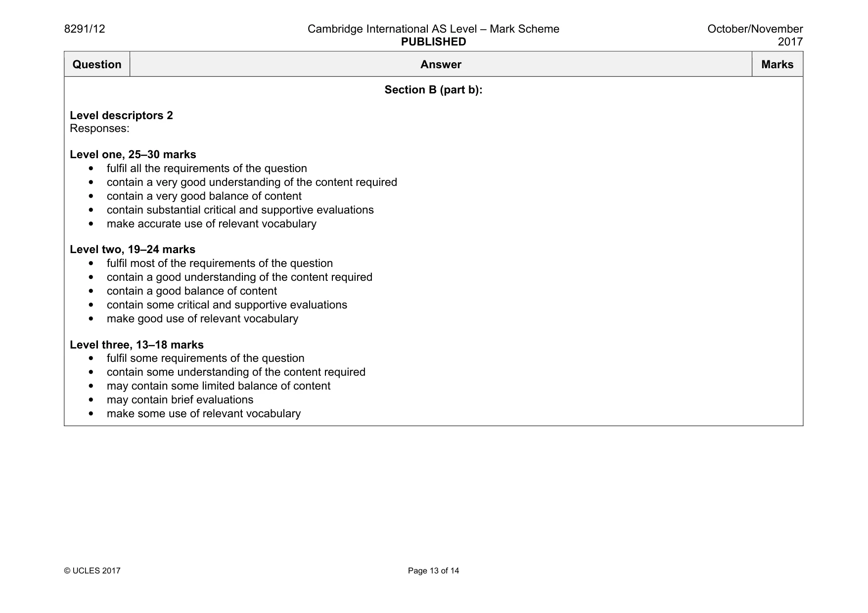
8291/12 Cambridge International AS Level – Mark Scheme PUBLISHED October/November 2017 © UCLES 2017 Page 13 of 14 Question Answer Marks Section B (part b): Level descriptors 2 Responses: Level one, 25–30 marks • fulfil all the requirements of the question • contain a very good understanding of the content required • contain a very good balance of content • contain substantial critical and supportive evaluations • make accurate use of relevant vocabulary Level two, 19–24 marks • fulfil most of the requirements of the question • contain a good understanding of the content required • contain a good balance of content • contain some critical and supportive evaluations • make good use of relevant vocabulary Level three, 13–18 marks • fulfil some requirements of the question • contain some understanding of the content required • may contain some limited balance of content • may contain brief evaluations • make some use of relevant vocabulary
Mark scheme, page 14
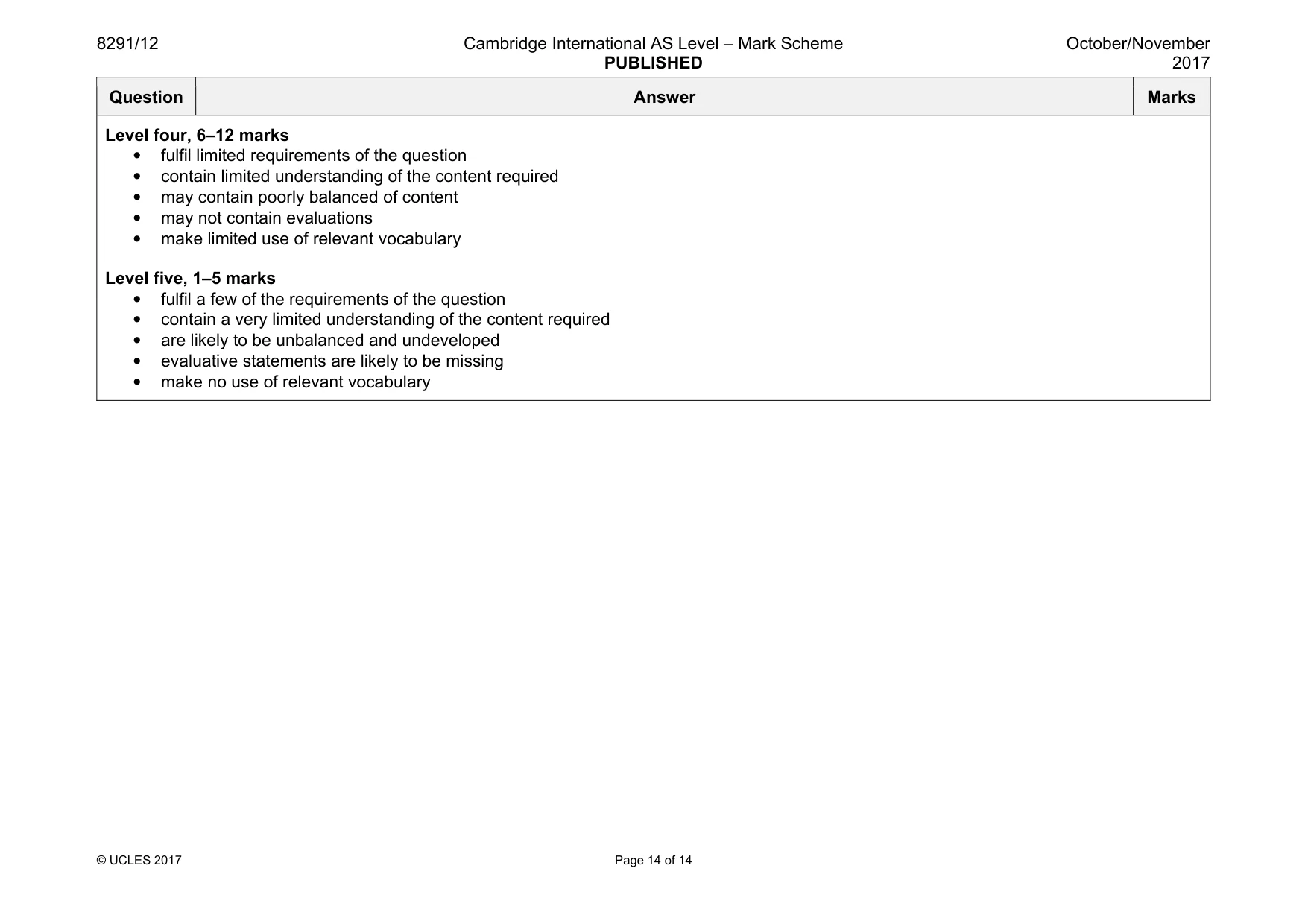
8291/12 Cambridge International AS Level – Mark Scheme PUBLISHED October/November 2017 © UCLES 2017 Page 14 of 14 Question Answer Marks Level four, 6–12 marks • fulfil limited requirements of the question • contain limited understanding of the content required • may contain poorly balanced of content • may not contain evaluations • make limited use of relevant vocabulary Level five, 1–5 marks • fulfil a few of the requirements of the question • contain a very limited understanding of the content required • are likely to be unbalanced and undeveloped • evaluative statements are likely to be missing • make no use of relevant vocabulary
What you needed in this session
Cambridge’s own grade thresholds for 2017 Oct/Nov, Paper 1 · Variant 2. A higher threshold means an easier paper — the bar moves with how the cohort did.