Cambridge A Level Environmental Management (AS only) 8291 — 2009 May/June Paper 1 · Variant 1
8291/11/M/J/09 · 80 marks · ≈90 min
The question paper and its mark scheme, free to read here and free to download. This is Cambridge’s own paper, exactly as it was sat.
Question paper12 pages


Mark scheme11 pages
Answers below. Sit the paper first if you are practising.
Paper as text
Question paper, page 1
This document consists of 10 printed pages and 2 blank pages. SPA (DR/DR) T78912/2 © UCLES 2009 [Turn over UNIVERSITY OF CAMBRIDGE INTERNATIONAL EXAMINATIONS General Certificate of Education Advanced Subsidiary Level and Advanced Level READ THESE INSTRUCTIONS FIRST Write your Centre number, candidate number and name on all the work you hand in. Write in dark blue or black pen. You may use a soft pencil for any diagrams, graphs, tables or rough working. Do not use staples, paper clips, highlighters, glue or correction fluid. DO NOT WRITE IN ANY BARCODES. Section A Answer all questions. Write your answers in the spaces provided on the question paper. Section B Answer one question from this section. Answer the question on the separate answer paper provided. At the end of the examination, 1. fasten all separate answer paper securely to the question paper; 2. enter the question number from Section B in the grid opposite. ENVIRONMENTAL MANAGEMENT 8291/01 Paper 1 Lithosphere and Atmosphere May/June 2009 1 hour 30 minutes Additional Materials: Answer Booklet/Paper For Examiner’s Use Section A 1 2 Section B Total * 0 9 2 1 0 3 8 7 9 1 *
Question paper, page 2
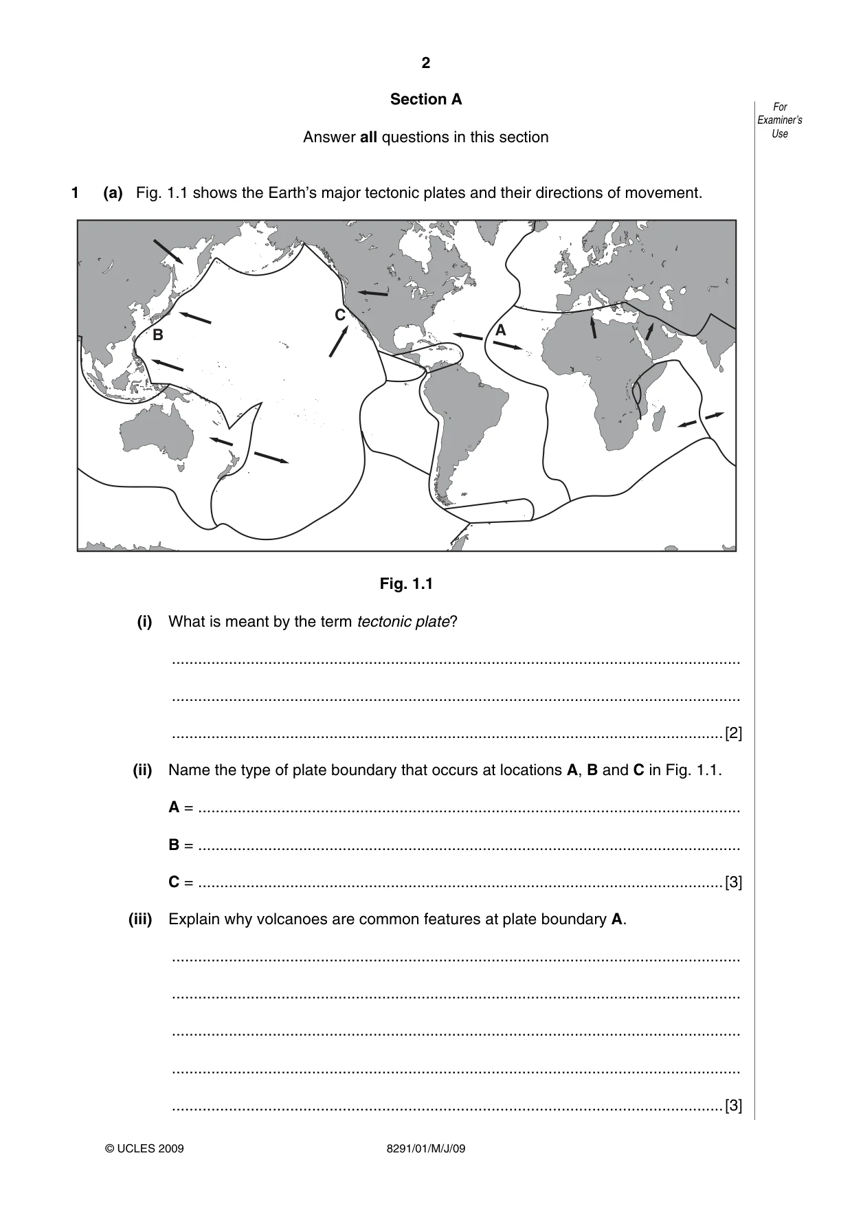
2 8291/01/M/J/09 For Examiner’s Use © UCLES 2009 Section A Answer all questions in this section 1 (a) Fig. 1.1 shows the Earth’s major tectonic plates and their directions of movement. C B A Fig. 1.1 (i) What is meant by the term tectonic plate? … … …[2] (ii) Name the type of plate boundary that occurs at locations A, B and C in Fig. 1.1. A = … B = … C = …[3] (iii) Explain why volcanoes are common features at plate boundary A. … … … … …[3]
Question paper, page 3
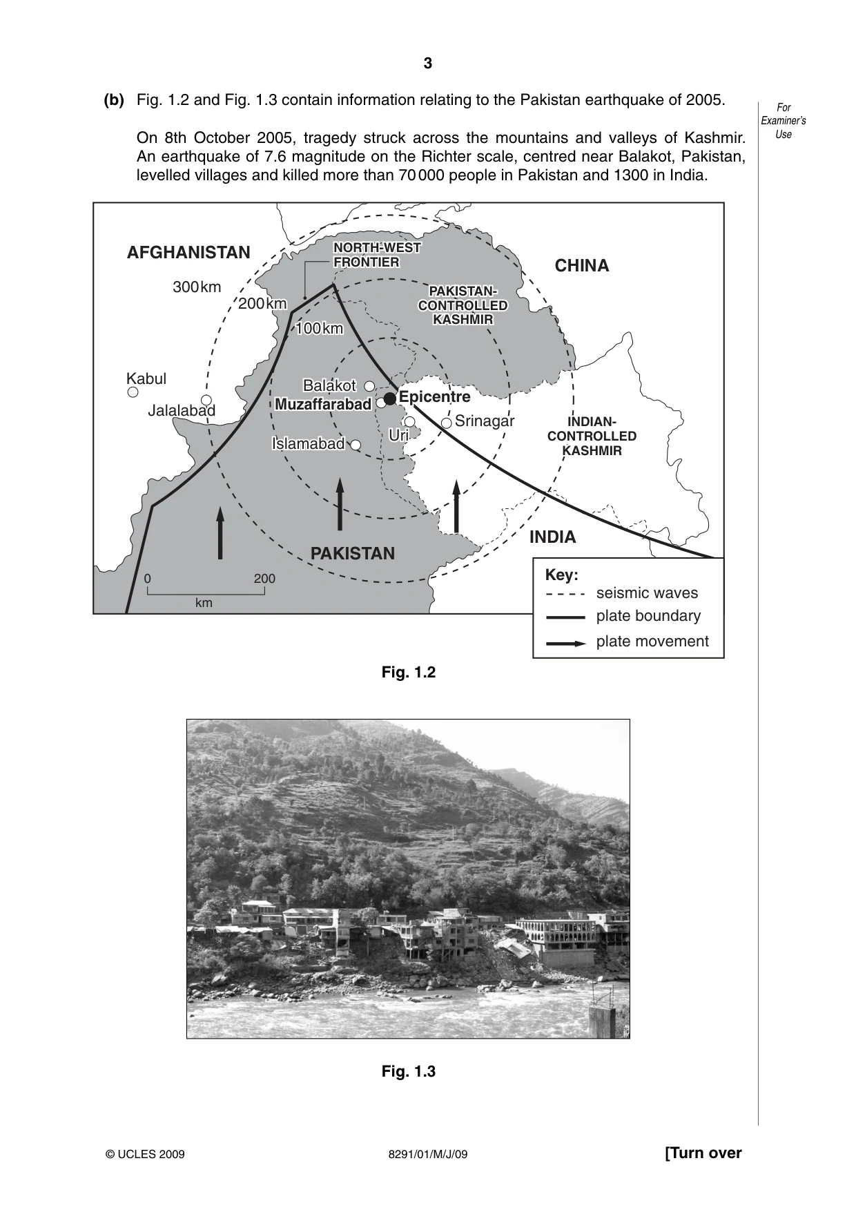
3 8291/01/M/J/09 [Turn over For Examiner’s Use © UCLES 2009 (b) Fig. 1.2 and Fig. 1.3 contain information relating to the Pakistan earthquake of 2005. On 8th October 2005, tragedy struck across the mountains and valleys of Kashmir. An earthquake of 7.6 magnitude on the Richter scale, centred near Balakot, Pakistan, levelled villages and killed more than 70 000 people in Pakistan and 1300 in India. Balakot Balakot Srinagar Srinagar Islamabad Islamabad Jalalabad Jalalabad Muzaffarabad Muzaffarabad Epicentre Epicentre 20 200km km INDIAN- INDIAN- CONTROLLED CONTROLLED KASHMIR KASHMIR PAKISTAN- PAKISTAN- CONTROLLED CONTROLLED KASHMIR KASHMIR 10 100km km Uri Uri NORTH-WEST NORTH-WEST FRONTIER FRONTIER Kabul Balakot Uri Srinagar Islamabad Jalalabad AFGHANISTAN CHINA INDIA PAKISTAN Muzaffarabad Epicentre 100km 200km 300km INDIAN- CONTROLLED KASHMIR PAKISTAN- CONTROLLED KASHMIR NORTH-WEST FRONTIER Key: seismic waves plate boundary plate movement 0 200 km Fig. 1.2 Fig. 1.3
Question paper, page 4
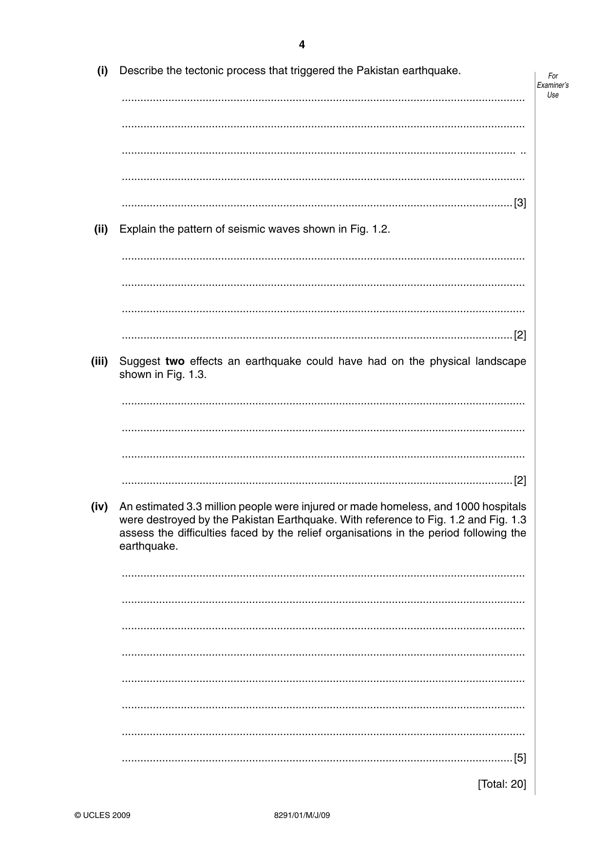
4 8291/01/M/J/09 For Examiner’s Use © UCLES 2009 (i) Describe the tectonic process that triggered the Pakistan earthquake. … … … .. … …[3] (ii) Explain the pattern of seismic waves shown in Fig. 1.2. … … … …[2] (iii) Suggest two effects an earthquake could have had on the physical landscape shown in Fig. 1.3. … … … …[2] (iv) An estimated 3.3 million people were injured or made homeless, and 1000 hospitals were destroyed by the Pakistan Earthquake. With reference to Fig. 1.2 and Fig. 1.3 assess the difficulties faced by the relief organisations in the period following the earthquake. … … … … … … … …[5] [Total: 20]
Question paper, page 5
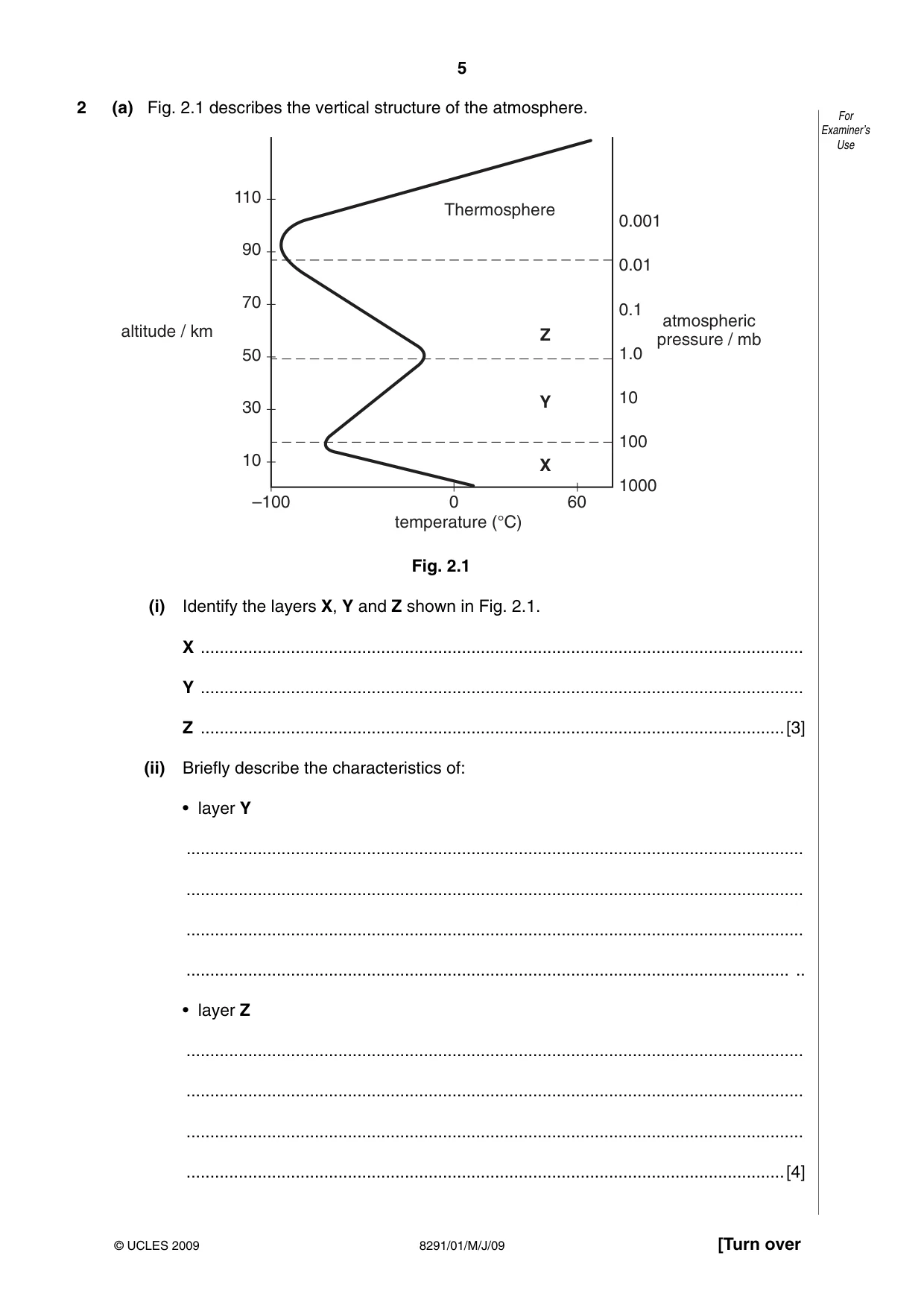
5 8291/01/M/J/09 [Turn over For Examiner’s Use © UCLES 2009 2 (a) Fig. 2.1 describes the vertical structure of the atmosphere. –100 0 temperature (°C) 60 1000 100 10 1.0 0.1 0.01 0.001 10 30 50 70 90 110 altitude / km atmospheric pressure / mb Z Y X Thermosphere Fig. 2.1 (i) Identify the layers X, Y and Z shown in Fig. 2.1. X … Y … Z …[3] (ii) Briefly describe the characteristics of: • layer Y … … … … .. • layer Z … … … …[4]
Question paper, page 6
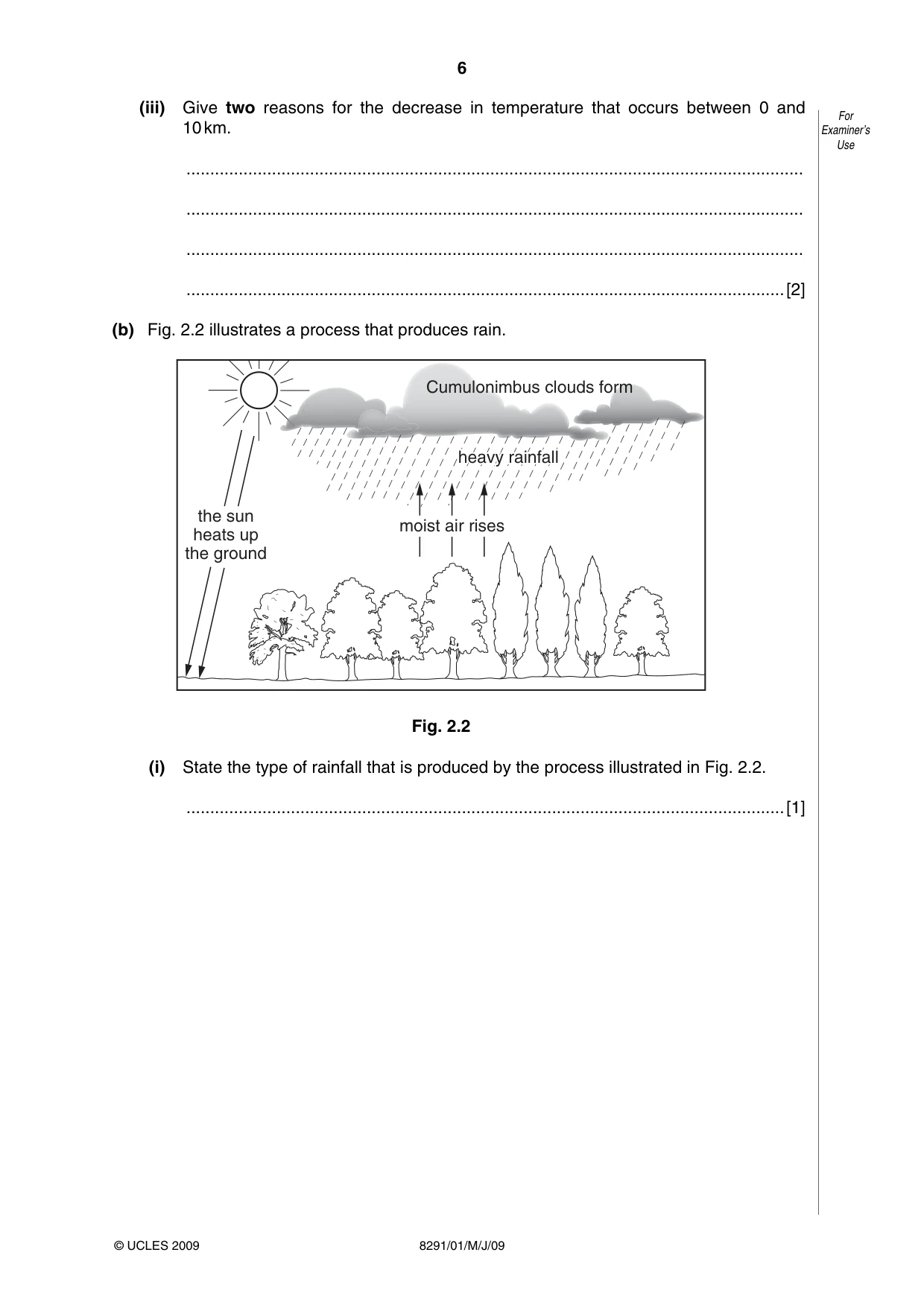
6 8291/01/M/J/09 For Examiner’s Use © UCLES 2009 (iii) Give two reasons for the decrease in temperature that occurs between 0 and 10 km. … … … …[2] (b) Fig. 2.2 illustrates a process that produces rain. moist air rises heavy rainfall heavy rainfall heavy rainfall the sun heats up the ground Cumulonimbus clouds form Fig. 2.2 (i) State the type of rainfall that is produced by the process illustrated in Fig. 2.2. …[1]
Question paper, page 7
7 8291/01/M/J/09 [Turn over For Examiner’s Use © UCLES 2009 (ii) Explain how temperature, water vapour and atmospheric pressure work together in the formation of the rainfall shown in Fig. 2.2. … … … … … … … … … …[5] (iii) Describe and explain the effects the removal of the vegetation cover in Fig. 2.2 would have on the climate of the area. … … … … … … … … … …[5] [Total: 20]
Question paper, page 8
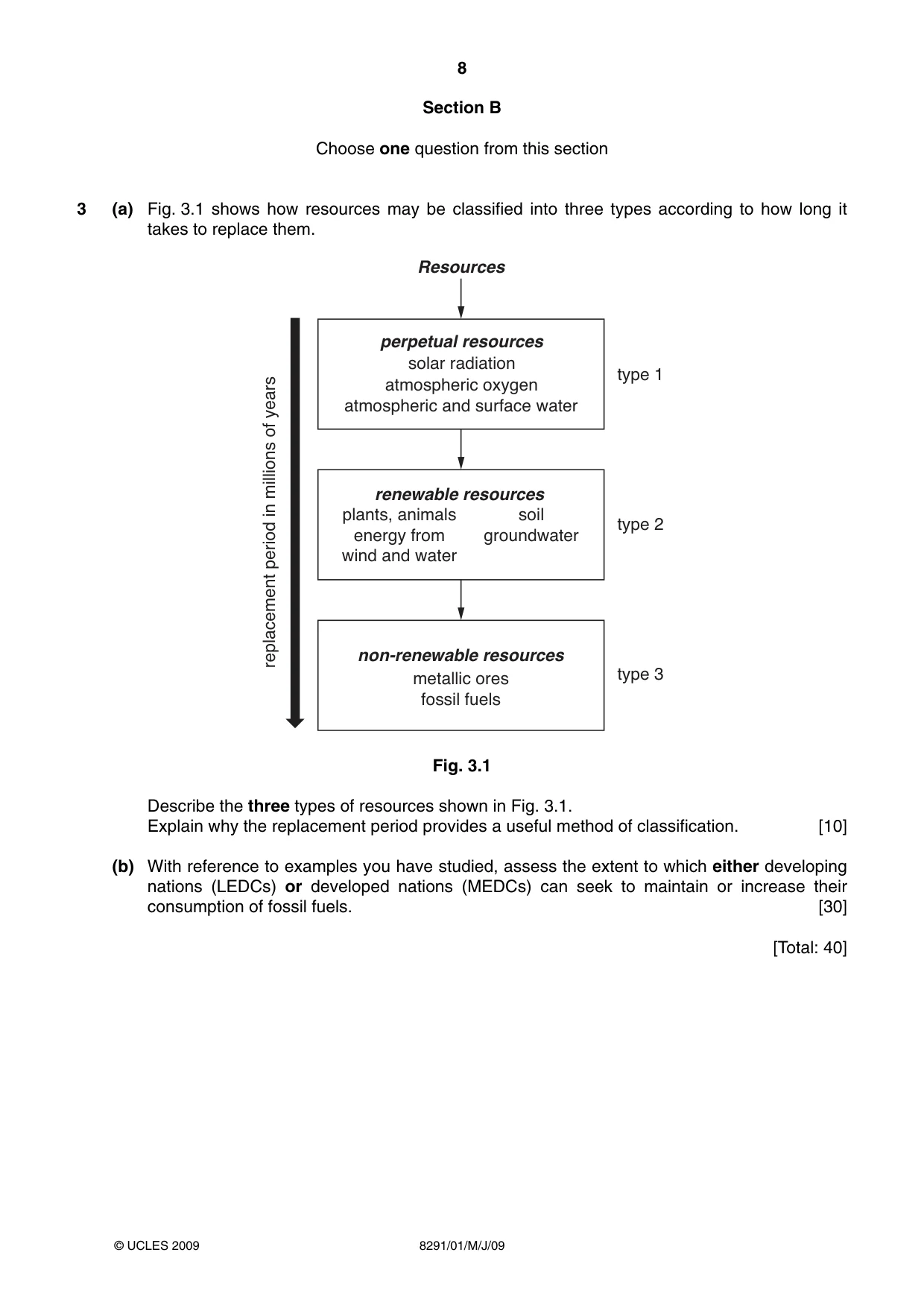
8 8291/01/M/J/09 © UCLES 2009 Section B Choose one question from this section 3 (a) Fig. 3.1 shows how resources may be classified into three types according to how long it takes to replace them. perpetual resources solar radiation atmospheric oxygen atmospheric and surface water renewable resources plants, animals soil energy from groundwater wind and water non-renewable resources metallic ores fossil fuels Resources type 1 type 2 type 3 replacement period in millions of years Fig. 3.1 Describe the three types of resources shown in Fig. 3.1. Explain why the replacement period provides a useful method of classification. [10] (b) With reference to examples you have studied, assess the extent to which either developing nations (LEDCs) or developed nations (MEDCs) can seek to maintain or increase their consumption of fossil fuels. [30] [Total: 40]
Question paper, page 9
9 8291/01/M/J/09 © UCLES 2009 [Turn over 4 (a) Burning fossil fuels can lead to the emission of acid gases. The quantities emitted can be reduced by taking action at any, or all, of the three stages in the combustion process. • before combustion • during combustion • after combustion Using examples, briefly describe why such actions might be more effective than managing the effects of acid deposition. [10] (b) For the purpose of this question you are to assume the role of an environmental planning officer responsible for either a named agricultural or a named urban region with which you are familiar. For either the agricultural area or the urban region area you have chosen, write a report that highlights the pollution issues and addresses their management. Your report should: • assess current pollution issues • consider public concerns • propose a strategy or strategies that target reducing levels of pollution. [30] [Total: 40]
Question paper, page 10
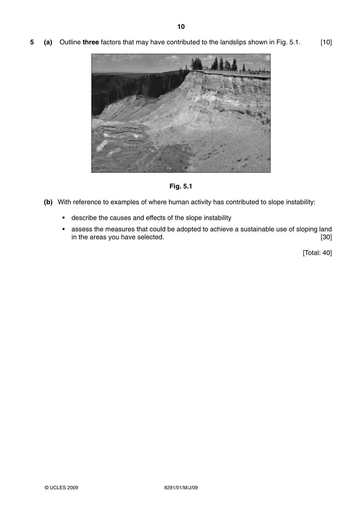
10 8291/01/M/J/09 © UCLES 2009 5 (a) Outline three factors that may have contributed to the landslips shown in Fig. 5.1. [10] Fig. 5.1 (b) With reference to examples of where human activity has contributed to slope instability: • describe the causes and effects of the slope instability • assess the measures that could be adopted to achieve a sustainable use of sloping land in the areas you have selected. [30] [Total: 40]
Question paper, page 12
12 8291/01/M/J/09 BLANK PAGE Permission to reproduce items where third-party owned material protected by copyright is included has been sought and cleared where possible. Every reasonable effort has been made by the publisher (UCLES) to trace copyright holders, but if any items requiring clearance have unwittingly been included, the publisher will be pleased to make amends at the earliest possible opportunity. University of Cambridge International Examinations is part of the Cambridge Assessment Group. Cambridge Assessment is the brand name of University of Cambridge Local Examinations Syndicate (UCLES), which is itself a department of the University of Cambridge.
Mark scheme, page 1
UNIVERSITY OF CAMBRIDGE INTERNATIONAL EXAMINATIONS GCE Advanced Subsidiary Level MARK SCHEME for the May/June 2009 question paper for the guidance of teachers 8291 ENVIRONMENTAL MANAGEMENT 8291/01 Paper 1, maximum raw mark 80 This mark scheme is published as an aid to teachers and candidates, to indicate the requirements of the examination. It shows the basis on which Examiners were instructed to award marks. It does not indicate the details of the discussions that took place at an Examiners’ meeting before marking began, which would have considered the acceptability of alternative answers. Mark schemes must be read in conjunction with the question papers and the report on the examination. • CIE will not enter into discussions or correspondence in connection with these mark schemes. CIE is publishing the mark schemes for the May/June 2009 question papers for most IGCSE, GCE Advanced Level and Advanced Subsidiary Level syllabuses and some Ordinary Level syllabuses.
Mark scheme, page 2
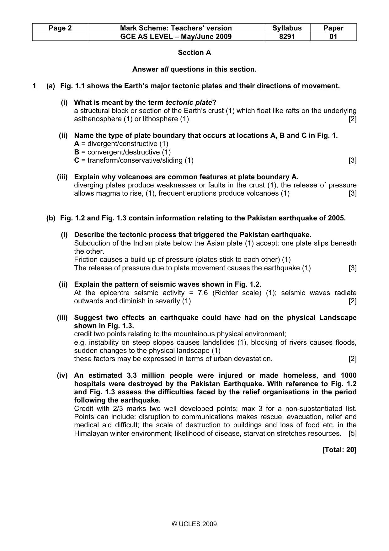
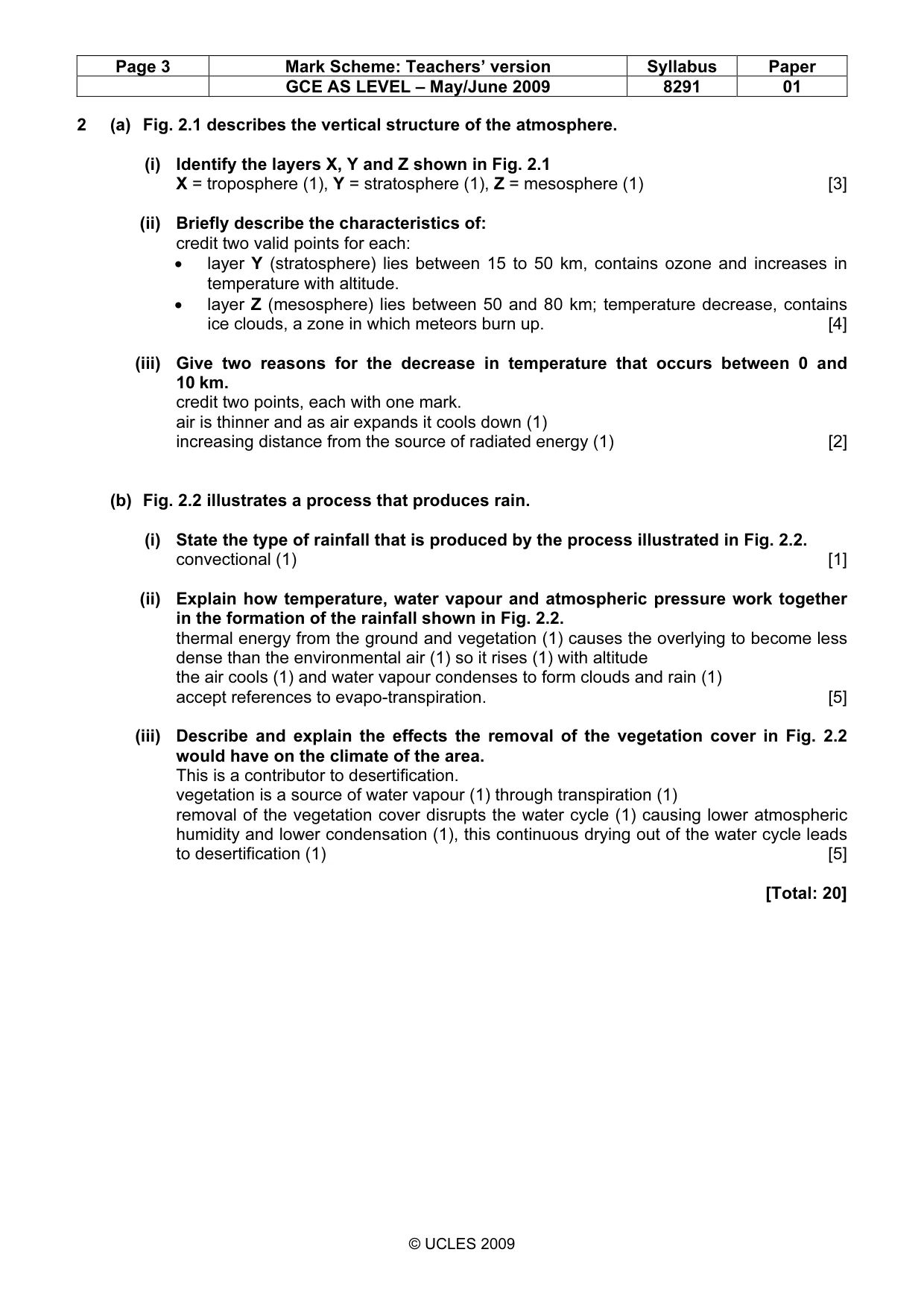
Page 2 Mark Scheme: Teachers’ version Syllabus Paper GCE AS LEVEL – May/June 2009 8291 01 © UCLES 2009 Section A Answer all questions in this section. 1 (a) Fig. 1.1 shows the Earth’s major tectonic plates and their directions of movement. (i) What is meant by the term tectonic plate? a structural block or section of the Earth’s crust (1) which float like rafts on the underlying asthenosphere (1) or lithosphere (1) [2] (ii) Name the type of plate boundary that occurs at locations A, B and C in Fig. 1. A = divergent/constructive (1) B = convergent/destructive (1) C = transform/conservative/sliding (1) [3] (iii) Explain why volcanoes are common features at plate boundary A. diverging plates produce weaknesses or faults in the crust (1), the release of pressure allows magma to rise, (1), frequent eruptions produce volcanoes (1) [3] (b) Fig. 1.2 and Fig. 1.3 contain information relating to the Pakistan earthquake of 2005. (i) Describe the tectonic process that triggered the Pakistan earthquake. Subduction of the Indian plate below the Asian plate (1) accept: one plate slips beneath the other. Friction causes a build up of pressure (plates stick to each other) (1) The release of pressure due to plate movement causes the earthquake (1) [3] (ii) Explain the pattern of seismic waves shown in Fig. 1.2. At the epicentre seismic activity = 7.6 (Richter scale) (1); seismic waves radiate outwards and diminish in severity (1) [2] (iii) Suggest two effects an earthquake could have had on the physical Landscape shown in Fig. 1.3. credit two points relating to the mountainous physical environment; e.g. instability on steep slopes causes landslides (1), blocking of rivers causes floods, sudden changes to the physical landscape (1) these factors may be expressed in terms of urban devastation. [2] (iv) An estimated 3.3 million people were injured or made homeless, and 1000 hospitals were destroyed by the Pakistan Earthquake. With reference to Fig. 1.2 and Fig. 1.3 assess the difficulties faced by the relief organisations in the period following the earthquake. Credit with 2/3 marks two well developed points; max 3 for a non-substantiated list. Points can include: disruption to communications makes rescue, evacuation, relief and medical aid difficult; the scale of destruction to buildings and loss of food etc. in the Himalayan winter environment; likelihood of disease, starvation stretches resources. [5] [Total: 20]
Mark scheme, page 3
Page 3 Mark Scheme: Teachers’ version Syllabus Paper GCE AS LEVEL – May/June 2009 8291 01 © UCLES 2009 2 (a) Fig. 2.1 describes the vertical structure of the atmosphere. (i) Identify the layers X, Y and Z shown in Fig. 2.1 X = troposphere (1), Y = stratosphere (1), Z = mesosphere (1) [3] (ii) Briefly describe the characteristics of: credit two valid points for each: • layer Y (stratosphere) lies between 15 to 50 km, contains ozone and increases in temperature with altitude. • layer Z (mesosphere) lies between 50 and 80 km; temperature decrease, contains ice clouds, a zone in which meteors burn up. [4] (iii) Give two reasons for the decrease in temperature that occurs between 0 and 10 km. credit two points, each with one mark. air is thinner and as air expands it cools down (1) increasing distance from the source of radiated energy (1) [2] (b) Fig. 2.2 illustrates a process that produces rain. (i) State the type of rainfall that is produced by the process illustrated in Fig. 2.2. convectional (1) [1] (ii) Explain how temperature, water vapour and atmospheric pressure work together in the formation of the rainfall shown in Fig. 2.2. thermal energy from the ground and vegetation (1) causes the overlying to become less dense than the environmental air (1) so it rises (1) with altitude the air cools (1) and water vapour condenses to form clouds and rain (1) accept references to evapo-transpiration. [5] (iii) Describe and explain the effects the removal of the vegetation cover in Fig. 2.2 would have on the climate of the area. This is a contributor to desertification. vegetation is a source of water vapour (1) through transpiration (1) removal of the vegetation cover disrupts the water cycle (1) causing lower atmospheric humidity and lower condensation (1), this continuous drying out of the water cycle leads to desertification (1) [5] [Total: 20]
Mark scheme, page 4
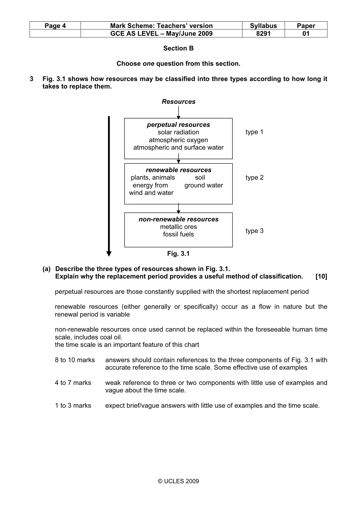
Page 4 Mark Scheme: Teachers’ version Syllabus Paper GCE AS LEVEL – May/June 2009 8291 01 © UCLES 2009 Section B Choose one question from this section. 3 Fig. 3.1 shows how resources may be classified into three types according to how long it takes to replace them. Resources type 1 type 2 type 3 Fig. 3.1 (a) Describe the three types of resources shown in Fig. 3.1. Explain why the replacement period provides a useful method of classification. [10] perpetual resources are those constantly supplied with the shortest replacement period renewable resources (either generally or specifically) occur as a flow in nature but the renewal period is variable non-renewable resources once used cannot be replaced within the foreseeable human time scale, includes coal oil. the time scale is an important feature of this chart 8 to 10 marks answers should contain references to the three components of Fig. 3.1 with accurate reference to the time scale. Some effective use of examples 4 to 7 marks weak reference to three or two components with little use of examples and vague about the time scale. 1 to 3 marks expect brief/vague answers with little use of examples and the time scale. renewable resources plants, animals soil energy from ground water wind and water non-renewable resources metallic ores fossil fuels perpetual resources solar radiation atmospheric oxygen atmospheric and surface water
Mark scheme, page 5
Page 5 Mark Scheme: Teachers’ version Syllabus Paper GCE AS LEVEL – May/June 2009 8291 01 © UCLES 2009 (b) With reference to examples you have studied, assess the extent to which either developing nations (LEDCs) or developed nations (MEDCs) can seek to maintain or increase their consumption of fossil fuels. [30] Although in past examinations this has proven to be a popular topic this question has a less open ended content. Here the emphasis is more concerned with the continued use of fossil fuels. Candidates need to select either MEDCs or LEDCs. MEDCs and LEDCs in maintaining their consumption of fossil fuels might consider: • existing reserves of oil, gas, coal • current domestic and industrial dependence on fossil fuels • current technology utilises fossil fuels; change can be expensive • thermal power stations have comparatively large output, gas and oil have quick start-up times • alternatives such as wind, solar, wave have low output, are less reliable, and expensive to set up. Increasing usage of fossil fuel would relate to: • new discoveries e.g. Arctic, Falklands etc. • limited technology and financial resources (LEDCs) • economic dependence • political factors The question of extent involves priorities: • the viability of alternatives • internal and external economic and political pressures Band 1 answers will have an appropriate emphasis, use examples and consider at least four reasons. Evaluation will feature strongly. (25–30) Band 3 answers will consider at least two reasons. Examples may have general coverage and evaluative statements will either be brief or one-sided. (13–18) Band 4 answers will consider at least on reason but have brief coverage. Examples will be poorly developed or implicit and there will be very little evaluation. (6–12) [Total: 40]
Mark scheme, page 6
Page 6 Mark Scheme: Teachers’ version Syllabus Paper GCE AS LEVEL – May/June 2009 8291 01 © UCLES 2009 4 (a) Burning fossil fuels can lead to the emission of acid gases. The quantities emitted can be reduced by taking action at any, or all, of the three stages in the combustion process. • before combustion • during combustion • after combustion Using examples, briefly describe why such actions might be more effective than managing the effects of acid deposition. [10] Notionally award 3 marks for reference to acid deposition, three marks for reference to the three stages and 4 marks for description, and then use the band descriptors. Acid deposition affects lakes, vegetation, buildings and is produced by burning fossil fuels, particularly SO2 and NOX. Management reduces the effects but not the cause. Pre-combustion mainly involves switching to cleaner fuels (high sulfur to low sulfur, petrol to hybrid or biofuels; coal washing, coal gasification. During combustion. Lime injection (multistage burning) reduces SO2 and NOX. Post combustion includes flue gas desulphurisation and catalytic systems are the most effective. 8 to 10 marks answers should contain reference to acid deposition and accurate reference to each of the three stages. Quality will be expressed through the level of understanding. 4 to 7 marks answers may contain reference to each part of the answer but lack understanding on probably the combustion stages. Expect some moderately reasoned but unbalanced answers in which one component is either good or only one dealt with. 1 to 3 marks answers will be very weak in the three combustion stages and contain limited reference to acid rain. The discussion in the question is not understood nor developed.
Mark scheme, page 7
Page 7 Mark Scheme: Teachers’ version Syllabus Paper GCE AS LEVEL – May/June 2009 8291 01 © UCLES 2009 (b) For the purpose of this question you are to assume the rôle of an environmental planning officer responsible for either a named agricultural or named urban region with which you are familiar. For either the agricultural or the urban region you have chosen, write a report that highlights the pollution issues and addresses their management. Your report should: • assess current pollution issues • consider public concerns • propose a strategy or strategies that target reducing levels of pollution. [30] As the choice is up to the candidate the mark scheme is generic. Notionally there should be a balance of 12 marks for current pollution issues 6 marks for public concerns and 12 marks for strategies Pollution issues should divide into sources, type and effect. Public concerns include health and expressed opinion. Strategies must directly relate to the first two sections and target reduction. Band 1 answers will contain a balance of the three elements and directly address the issues affecting the area chosen. The answer will contain evaluations of the effects of the pollution and the related strategies. (25–30) Band 3 answers although relevant may lack balance or contain brief descriptions of each element. Evaluations may be confined to brief statements. Max band 3 if an example is not used. (13–18) Band 4 answers may be very brief and general, comprise listed statements. There may well be a lack of balance with one or two elements of the report omitted. (6-12) [Total: 40]
Mark scheme, page 8
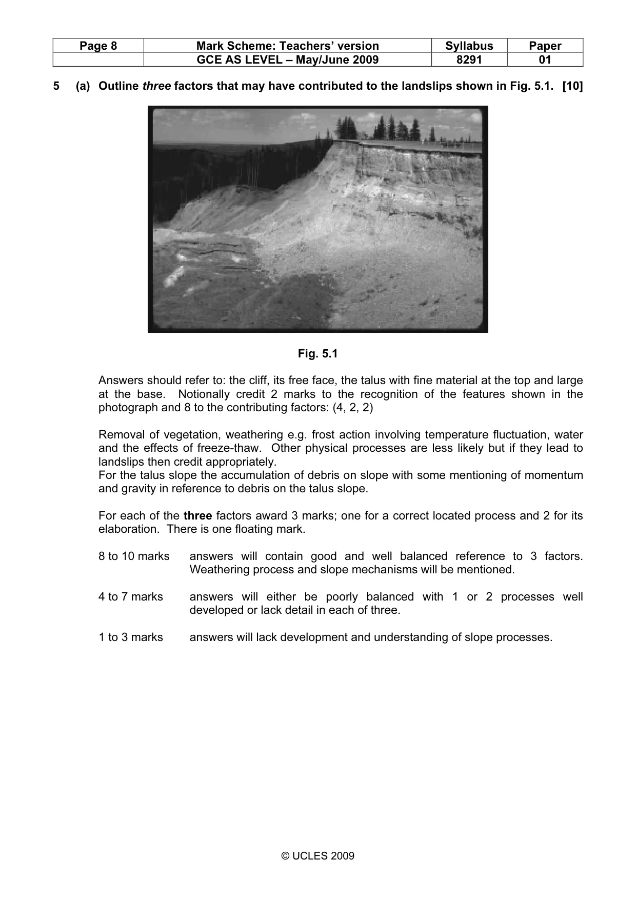
Page 8 Mark Scheme: Teachers’ version Syllabus Paper GCE AS LEVEL – May/June 2009 8291 01 © UCLES 2009 5 (a) Outline three factors that may have contributed to the landslips shown in Fig. 5.1. [10] Fig. 5.1 Answers should refer to: the cliff, its free face, the talus with fine material at the top and large at the base. Notionally credit 2 marks to the recognition of the features shown in the photograph and 8 to the contributing factors: (4, 2, 2) Removal of vegetation, weathering e.g. frost action involving temperature fluctuation, water and the effects of freeze-thaw. Other physical processes are less likely but if they lead to landslips then credit appropriately. For the talus slope the accumulation of debris on slope with some mentioning of momentum and gravity in reference to debris on the talus slope. For each of the three factors award 3 marks; one for a correct located process and 2 for its elaboration. There is one floating mark. 8 to 10 marks answers will contain good and well balanced reference to 3 factors. Weathering process and slope mechanisms will be mentioned. 4 to 7 marks answers will either be poorly balanced with 1 or 2 processes well developed or lack detail in each of three. 1 to 3 marks answers will lack development and understanding of slope processes.
Mark scheme, page 9
Page 9 Mark Scheme: Teachers’ version Syllabus Paper GCE AS LEVEL – May/June 2009 8291 01 © UCLES 2009 (b) With reference to examples of where human activity has contributed to slope instability: • describe the causes and effects of the slope instability • assess the measures that could be adopted to achieve a sustainable use of sloping land in the areas you have selected. [30] The two parts to this question should have equal weighting to achieve the correct balance. Although the emphasis is on human activity its relevance is in the exposure of, steepening and disruption to slopes that enables physical processes to operate. Hopefully candidates will select examples with which they are either familiar and/or have studied. Causes include: quarrying, building, deforestation, agriculture. Effects are usually exposure to weathering, steepening and drainage. To be seen in landslips, building collapse, gullying and in general loss of land. Strategies include: reforestation, terracing, slope reinforcement (gabions), building restrictions, multiple cropping. These permit continued use of the slope whilst reducing the likelihood of slope failure. Band 1 answers must contain a good balance of both elements and be clear about the effects of human activity and the sustainable use of slopes. There should be effective assessment of the strategies. (25–30) Band 3 answers may be stronger in one element, lack clarity on sustainability and contain limited assessment. (13–18) Band 4 answers although relevant will tend to be brief and non-evaluative. (6–12) [Total: 40]
Mark scheme, page 10
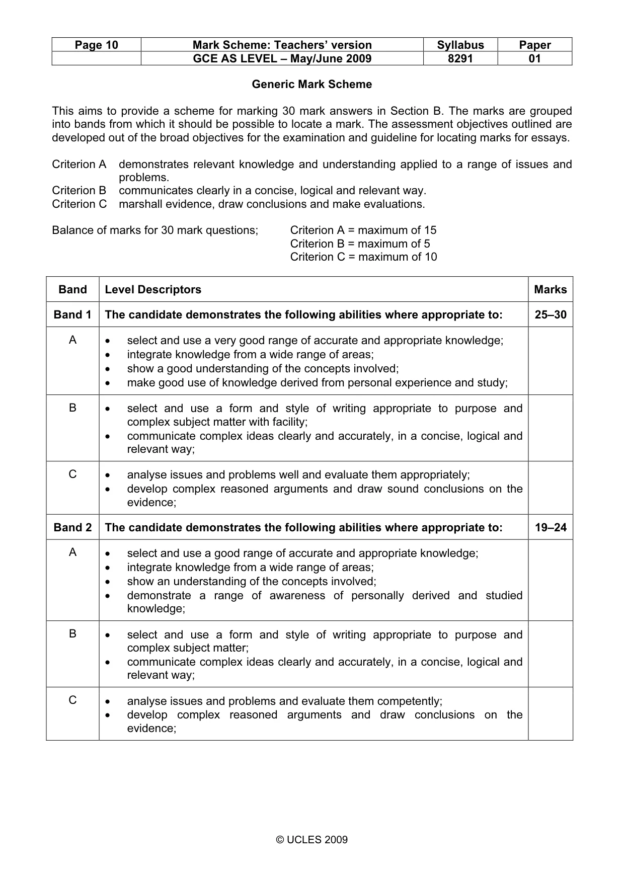
Page 10 Mark Scheme: Teachers’ version Syllabus Paper GCE AS LEVEL – May/June 2009 8291 01 © UCLES 2009 Generic Mark Scheme This aims to provide a scheme for marking 30 mark answers in Section B. The marks are grouped into bands from which it should be possible to locate a mark. The assessment objectives outlined are developed out of the broad objectives for the examination and guideline for locating marks for essays. Criterion A demonstrates relevant knowledge and understanding applied to a range of issues and problems. Criterion B communicates clearly in a concise, logical and relevant way. Criterion C marshall evidence, draw conclusions and make evaluations. Balance of marks for 30 mark questions; Criterion A = maximum of 15 Criterion B = maximum of 5 Criterion C = maximum of 10 Band Level Descriptors Marks Band 1 The candidate demonstrates the following abilities where appropriate to: 25–30 A • select and use a very good range of accurate and appropriate knowledge; • integrate knowledge from a wide range of areas; • show a good understanding of the concepts involved; • make good use of knowledge derived from personal experience and study; B • select and use a form and style of writing appropriate to purpose and complex subject matter with facility; • communicate complex ideas clearly and accurately, in a concise, logical and relevant way; C • analyse issues and problems well and evaluate them appropriately; • develop complex reasoned arguments and draw sound conclusions on the evidence; Band 2 The candidate demonstrates the following abilities where appropriate to: 19–24 A • select and use a good range of accurate and appropriate knowledge; • integrate knowledge from a wide range of areas; • show an understanding of the concepts involved; • demonstrate a range of awareness of personally derived and studied knowledge; B • select and use a form and style of writing appropriate to purpose and complex subject matter; • communicate complex ideas clearly and accurately, in a concise, logical and relevant way; C • analyse issues and problems and evaluate them competently; • develop complex reasoned arguments and draw conclusions on the evidence;
Mark scheme, page 11
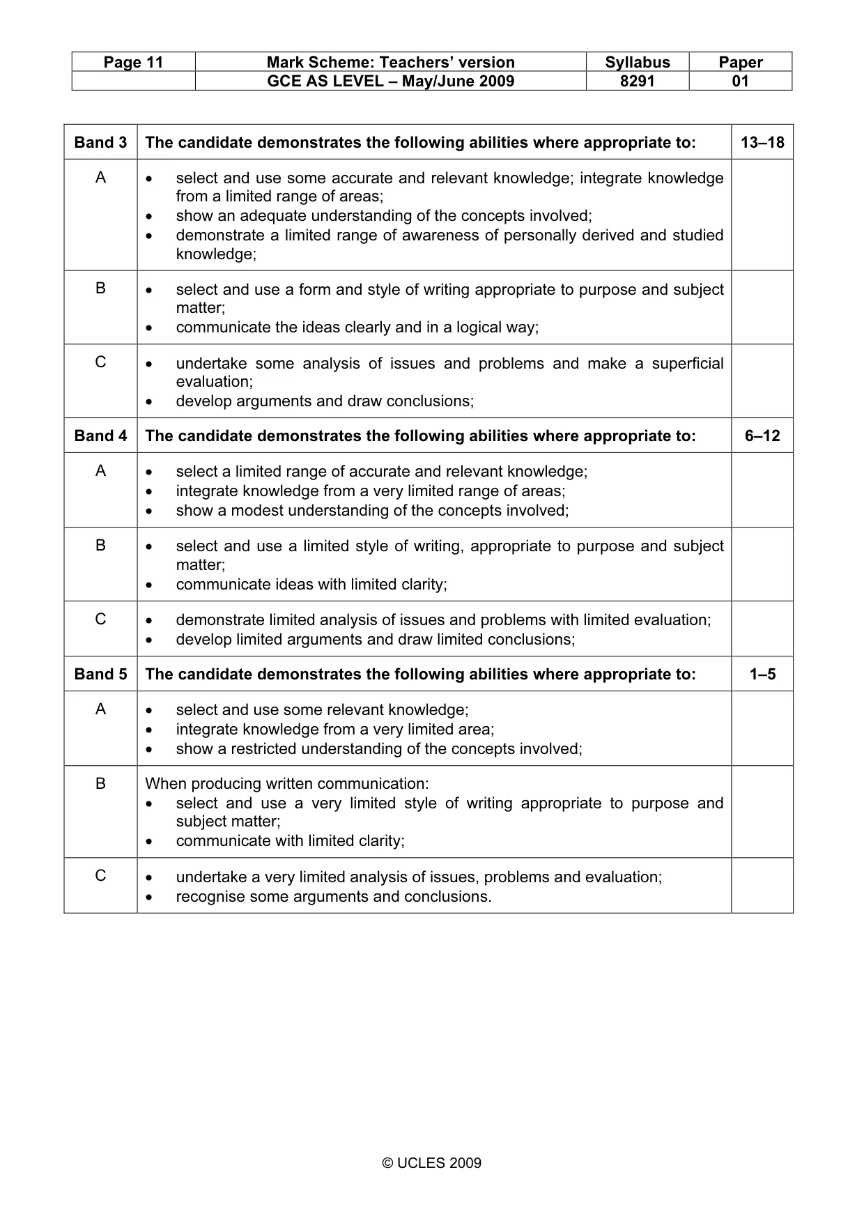
Page 11 Mark Scheme: Teachers’ version Syllabus Paper GCE AS LEVEL – May/June 2009 8291 01 © UCLES 2009 Band 3 The candidate demonstrates the following abilities where appropriate to: 13–18 A • select and use some accurate and relevant knowledge; integrate knowledge from a limited range of areas; • show an adequate understanding of the concepts involved; • demonstrate a limited range of awareness of personally derived and studied knowledge; B • select and use a form and style of writing appropriate to purpose and subject matter; • communicate the ideas clearly and in a logical way; C • undertake some analysis of issues and problems and make a superficial evaluation; • develop arguments and draw conclusions; Band 4 The candidate demonstrates the following abilities where appropriate to: 6–12 A • select a limited range of accurate and relevant knowledge; • integrate knowledge from a very limited range of areas; • show a modest understanding of the concepts involved; B • select and use a limited style of writing, appropriate to purpose and subject matter; • communicate ideas with limited clarity; C • demonstrate limited analysis of issues and problems with limited evaluation; • develop limited arguments and draw limited conclusions; Band 5 The candidate demonstrates the following abilities where appropriate to: 1–5 A • select and use some relevant knowledge; • integrate knowledge from a very limited area; • show a restricted understanding of the concepts involved; B When producing written communication: • select and use a very limited style of writing appropriate to purpose and subject matter; • communicate with limited clarity; C • undertake a very limited analysis of issues, problems and evaluation; • recognise some arguments and conclusions.
What you needed in this session
Cambridge’s own grade thresholds for 2009 May/June, Paper 1 · Variant 1. A higher threshold means an easier paper — the bar moves with how the cohort did.