Cambridge IGCSE Geography 0460 — 2003 Oct/Nov Paper 3 · Variant 1
0460/31/O/N/03
The question paper and its mark scheme, free to read here and free to download. This is Cambridge’s own paper, exactly as it was sat.
Question paper8 pages

Mark scheme
No mark scheme is in the library for this paper.
Paper as text
Question paper, page 1
This document consists of 8 printed pages, an insert and a survey map. MML 3242 5/02 S40695/1 © CIE 2003 [Turn over CAMBRIDGE INTERNATIONAL EXAMINATIONS International General Certificate of Secondary Education GEOGRAPHY 0460/03 Paper 3 October/November 2003 1 hour 30 minutes Additional Materials: Answer Booklet/Paper Ruler Protractor Set square 1:50 000 survey map is enclosed with this question paper. READ THESE INSTRUCTIONS FIRST If you have been given an Answer Booklet, follow the instructions on the front cover of the Booklet. Write your Centre number, candidate number and name on all the work you hand in. Write in dark blue or black pen on both sides of the paper. You may use a soft pencil for any diagrams, graphs or rough working. Do not use staples, paper clips, highlighters, glue or correction fluid. Answer all questions. At the end of the examination, fasten all your work securely together. The number of marks is given in brackets [ ] at the end of each question or part question. The insert contains the diagrams referred to in the question paper. UNIVERSITY of CAMBRIDGE Local Examinations Syndicate www.XtremePapers.com
Question paper, page 2
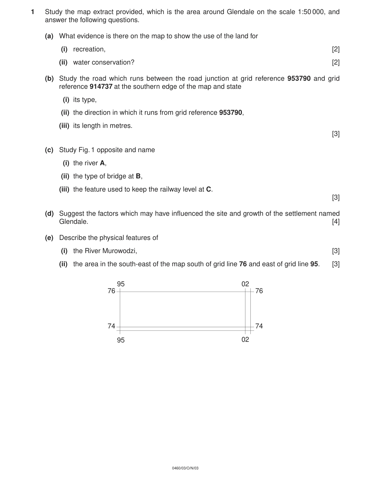
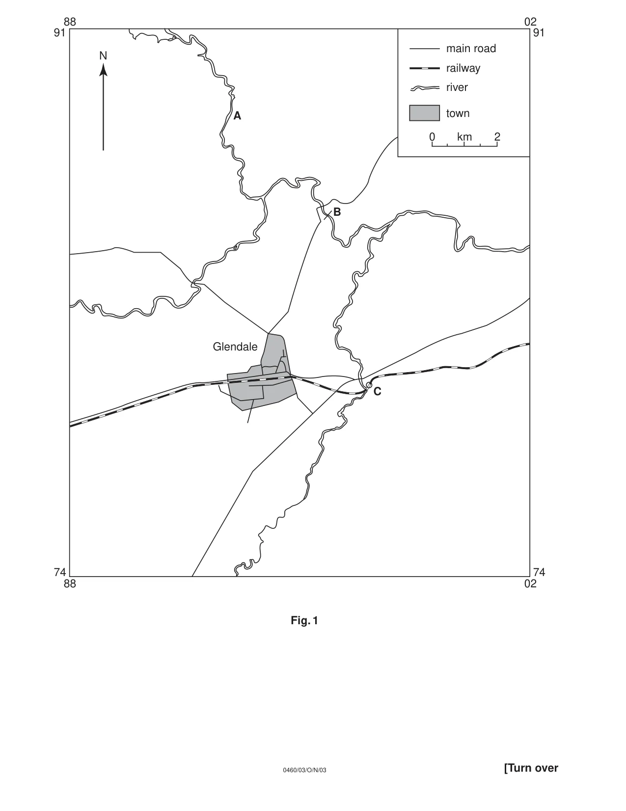
1 Study the map extract provided, which is the area around Glendale on the scale 1:50 000, and answer the following questions. (a) What evidence is there on the map to show the use of the land for (i) recreation, [2] (ii) water conservation? [2] (b) Study the road which runs between the road junction at grid reference 953790 and grid reference 914737 at the southern edge of the map and state (i) its type, (ii) the direction in which it runs from grid reference 953790, (iii) its length in metres. [3] (c) Study Fig. 1 opposite and name (i) the river A, (ii) the type of bridge at B, (iii) the feature used to keep the railway level at C. [3] (d) Suggest the factors which may have influenced the site and growth of the settlement named Glendale. [4] (e) Describe the physical features of (i) the River Murowodzi, [3] (ii) the area in the south-east of the map south of grid line 76 and east of grid line 95. [3] 0460/03/O/N/03 95 95 02 02 76 76 74 74
Question paper, page 3
Fig. 1 B A main road railway river town 0 km 2 N C 91 91 88 02 02 88 74 74 Glendale [Turn over 0460/03/O/N/03
Question paper, page 4
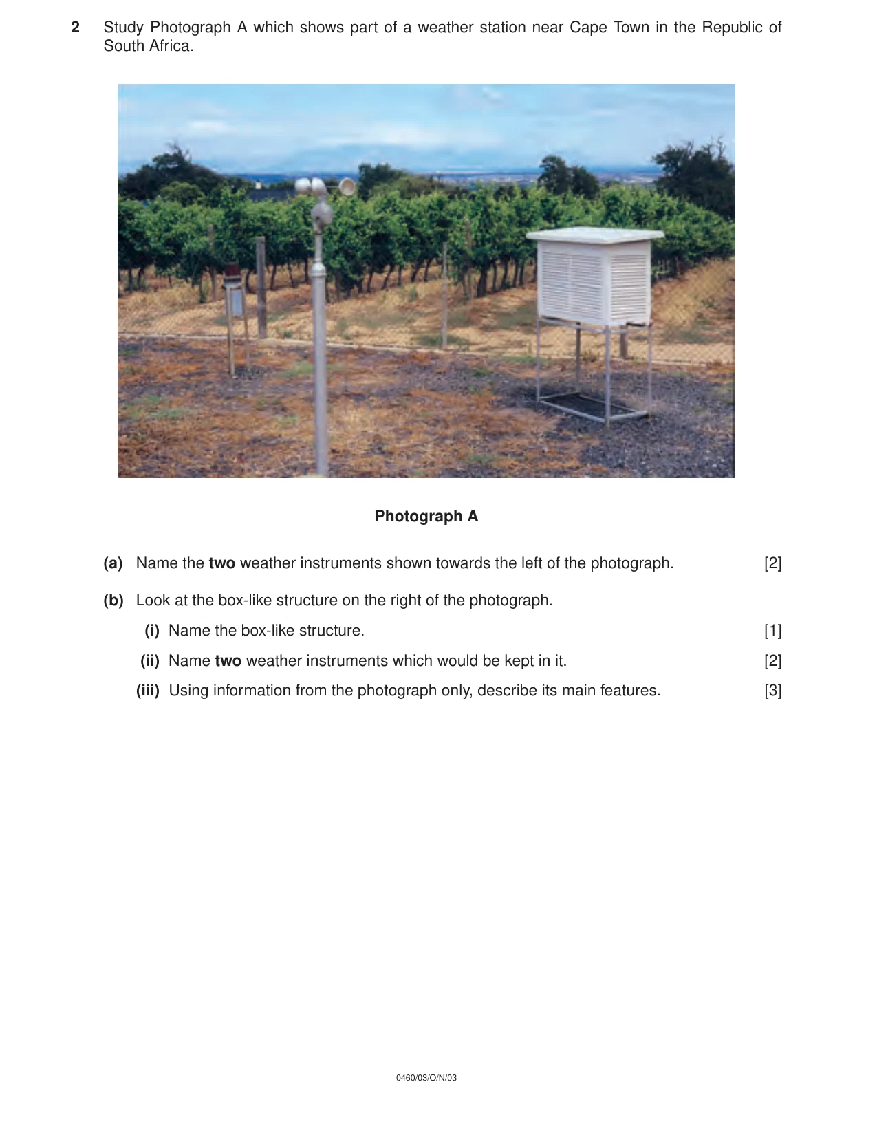
2 Study Photograph A which shows part of a weather station near Cape Town in the Republic of South Africa. Photograph A (a) Name the two weather instruments shown towards the left of the photograph. [2] (b) Look at the box-like structure on the right of the photograph. (i) Name the box-like structure. [1] (ii) Name two weather instruments which would be kept in it. [2] (iii) Using information from the photograph only, describe its main features. [3] 0460/03/O/N/03
Question paper, page 5
3 Fig. 2 (Insert) gives information about life expectancy and natural population increase in several countries. (a) How is natural population increase calculated? [2] (b) In which country, shown on Fig. 2, is the natural population increase 0.6% and life expectancy 71 years? [1] (c) On the graph (i) draw a straight line across the graph to separate the developing countries from the developed countries, [1] (ii) mark with a dot the position of Pakistan which has a population increase of 3.0% and a life expectancy of 56 years. [1] (d) What relationship between life expectancy and natural population increase is shown on Fig. 2? [1] 4 The divided bar charts, Fig. 3 (Insert) will, when completed, show the percentages of people in different occupations in both developed and developing countries. (a) Complete the bar for country A using the following figures: Primary occupations 5% Secondary occupations 35% Tertiary occupations 60% [2] (b) Calculate the difference in the percentages of people employed in the tertiary occupations between country A and country B. [1] (c) Which of the countries, A or B, is a developing country? [1] 5 Study the information about two residential areas in a city in a developed country (Fig. 4, Insert). (a) Complete the age pattern graphs by using the following figures: Area A 15 – 34 years 24% Area B 35 – 59 years 38% [2] (b) What percentage of the houses in Area A is lived in by the owner? [1] (c) Using information from Fig. 4, give three reasons to explain why the quality of life is likely to be poorer in Area A than in Area B. [3] [Turn over 0460/03/O/N/03
Question paper, page 6
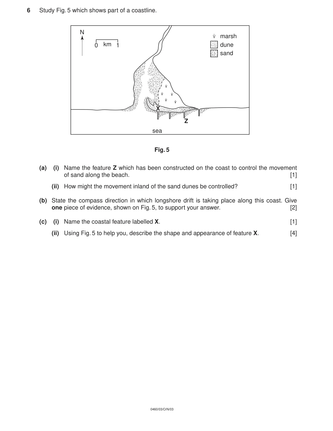
6 Study Fig. 5 which shows part of a coastline. Fig. 5 (a) (i) Name the feature Z which has been constructed on the coast to control the movement of sand along the beach. [1] (ii) How might the movement inland of the sand dunes be controlled? [1] (b) State the compass direction in which longshore drift is taking place along this coast. Give one piece of evidence, shown on Fig. 5, to support your answer. [2] (c) (i) Name the coastal feature labelled X. [1] (ii) Using Fig. 5 to help you, describe the shape and appearance of feature X. [4] marsh sand dune X Z km 0 1 N sea 0460/03/O/N/03
Question paper, page 7
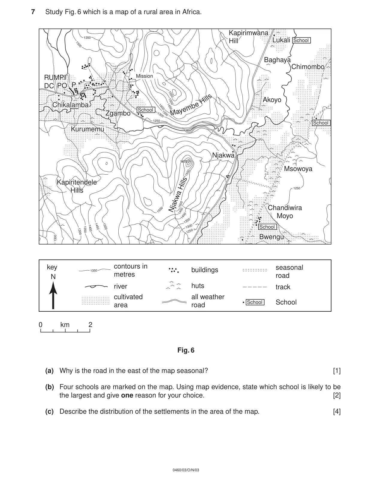
7 Study Fig. 6 which is a map of a rural area in Africa. Fig. 6 (a) Why is the road in the east of the map seasonal? [1] (b) Four schools are marked on the map. Using map evidence, state which school is likely to be the largest and give one reason for your choice. [2] (c) Describe the distribution of the settlements in the area of the map. [4] 1300 1300 1350 1350 1400 1450 1500 1500 1250 1300 1350 1400 1450 1500 1550 1250 1350 1300 1550 1500 1450 1672 1672 1250 1300 1350 1400 Kurumemui Chikalamba Baghaya Lukali School School School School School School Kapiritendele Hills Njakwa Hills Mission Mission Kapirimwana hill Kapirimwana Hill PO Bwengu Bwengu Chandiwira Moyo Msowoya Chimombo Chimombo Akoyo Njakwa Zgambo P N key contours in metres river cultivated area buildings huts all weather road seasonal road track 0 2 km Kapiritendele Hills M ay e m be H il ls RUMPI DC Kapirimwana Hill Kurumemu Chikalamba Lukali Chimombo Zgambo M ay e m be H il ls PO P RUMPI DC 0460/03/O/N/03
Question paper, page 8
Copyright Acknowledgements: Question 2. Photograph, R Howarth. Cambridge International Examinations has made every effort to trace copyright holders, but if we have inadvertently overlooked any we will be pleased to make the necessary arrangements at the first opportunity. 0460/03/O/N/03