Cambridge IGCSE Geography 0460 — 2003 May/June Paper 3 · Variant 1
0460/31/M/J/03
The question paper and its mark scheme, free to read here and free to download. This is Cambridge’s own paper, exactly as it was sat.
Question paper12 pages


Mark scheme
No mark scheme is in the library for this paper.
Paper as text
Question paper, page 1
This document consists of 9 printed pages, 3 blank pages and an insert. MML 3189 4/02 S41317/2 © CIE 2003 [Turn over CAMBRIDGE INTERNATIONAL EXAMINATIONS International General Certificate of Secondary Education GEOGRAPHY 0460/03 Paper 3 May/June 2003 1 hour 30 minutes Additional Materials: Answer Booklet/Paper Ruler Protractor 1:25 000 survey map is enclosed with this question paper. READ THESE INSTRUCTIONS FIRST If you have been given an Answer Booklet, follow the instructions on the front cover of the Booklet. Write your Centre number, candidate number and name on all the work you hand in. Write in dark blue or black pen on both sides of the paper. You may use a soft pencil for any diagrams, graphs or rough working. Do not use staples, paper clips, highlighters, glue or correction fluid. Answer all questions. At the end of the examination, fasten all your work securely together. The number of marks is given in brackets [ ] at the end of each question or part question. The insert contains Fig. 3 for Question 4. Sketch maps and diagrams should be drawn whenever they serve to illustrate an answer. UNIVERSITY of CAMBRIDGE Local Examinations Syndicate www.XtremePapers.com
Question paper, page 2
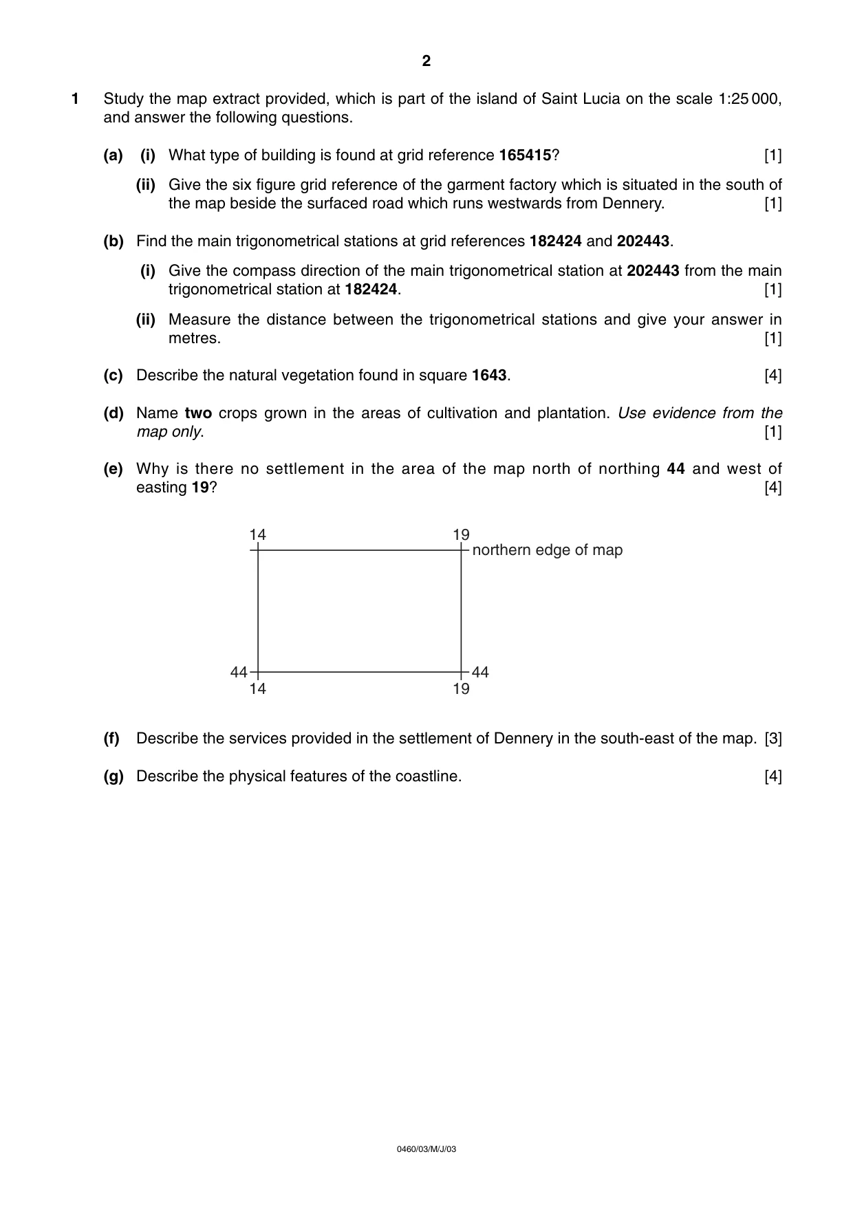
1 Study the map extract provided, which is part of the island of Saint Lucia on the scale 1:25 000, and answer the following questions. (a) (i) What type of building is found at grid reference 165415? [1] (ii) Give the six figure grid reference of the garment factory which is situated in the south of the map beside the surfaced road which runs westwards from Dennery. [1] (b) Find the main trigonometrical stations at grid references 182424 and 202443. (i) Give the compass direction of the main trigonometrical station at 202443 from the main trigonometrical station at 182424. [1] (ii) Measure the distance between the trigonometrical stations and give your answer in metres. [1] (c) Describe the natural vegetation found in square 1643. [4] (d) Name two crops grown in the areas of cultivation and plantation. Use evidence from the map only. [1] (e) Why is there no settlement in the area of the map north of northing 44 and west of easting 19? [4] (f) Describe the services provided in the settlement of Dennery in the south-east of the map. [3] (g) Describe the physical features of the coastline. [4] 14 14 19 19 44 44 northern edge of map 2 0460/03/M/J/03
Question paper, page 3
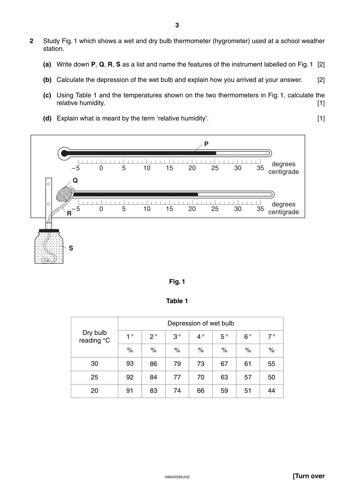
2 Study Fig. 1 which shows a wet and dry bulb thermometer (hygrometer) used at a school weather station. (a) Write down P, Q, R, S as a list and name the features of the instrument labelled on Fig. 1 [2] (b) Calculate the depression of the wet bulb and explain how you arrived at your answer. [2] (c) Using Table 1 and the temperatures shown on the two thermometers in Fig. 1, calculate the relative humidity. [1] (d) Explain what is meant by the term ‘relative humidity’. [1] Fig. 1 Table 1 0 –5 5 10 15 20 25 30 35 0 –5 5 10 15 20 25 30 35 degrees centigrade degrees centigrade P Q R S 3 [Turn over 0460/03/M/J/03 Dry bulb reading °C 30 25 20 Depression of wet bulb 1 ° 2 ° 3 ° 4 ° 5 ° 6 ° 7 ° % 93 92 91 % 86 84 83 % 79 77 74 % 73 70 66 % 67 63 59 % 61 57 51 % 55 50 44
Question paper, page 4
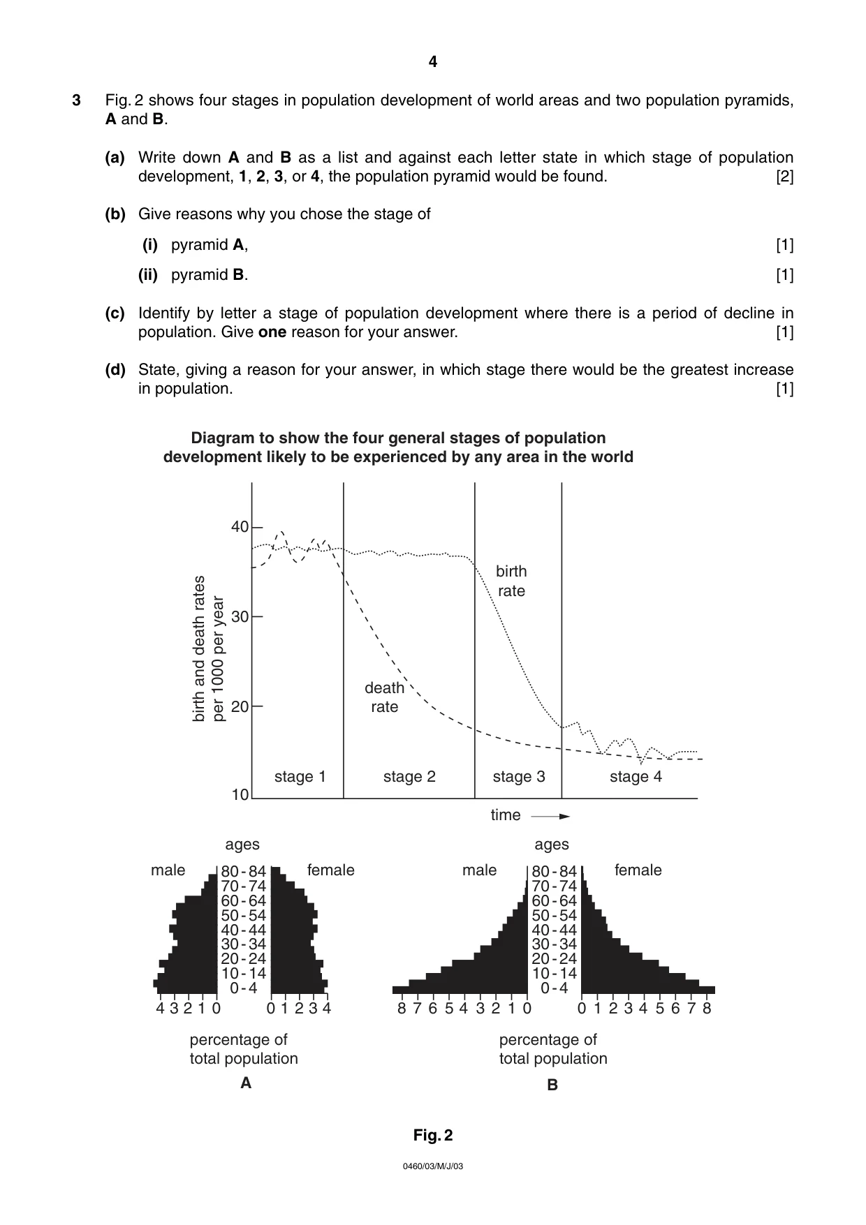
3 Fig. 2 shows four stages in population development of world areas and two population pyramids, A and B. (a) Write down A and B as a list and against each letter state in which stage of population development, 1, 2, 3, or 4, the population pyramid would be found. [2] (b) Give reasons why you chose the stage of (i) pyramid A, [1] (ii) pyramid B. [1] (c) Identify by letter a stage of population development where there is a period of decline in population. Give one reason for your answer. [1] (d) State, giving a reason for your answer, in which stage there would be the greatest increase in population. [1] Fig. 2 ages male percentage of total population female ages male percentage of total population female 80-84 70-74 60-64 50-54 40-44 30-34 20-24 10-14 0-4 80-84 70-74 60-64 50-54 40-44 30-34 20-24 10-14 0-4 B A 0 1 2 3 4 0 0 1 2 3 4 5 6 7 8 1 2 3 4 5 0 1 2 3 4 6 7 8 10 20 30 40 stage 1 stage 2 stage 3 stage 4 birth rate death rate birth and death rates per 1000 per year time Diagram to show the four general stages of population development likely to be experienced by any area in the world 4 0460/03/M/J/03
Question paper, page 5
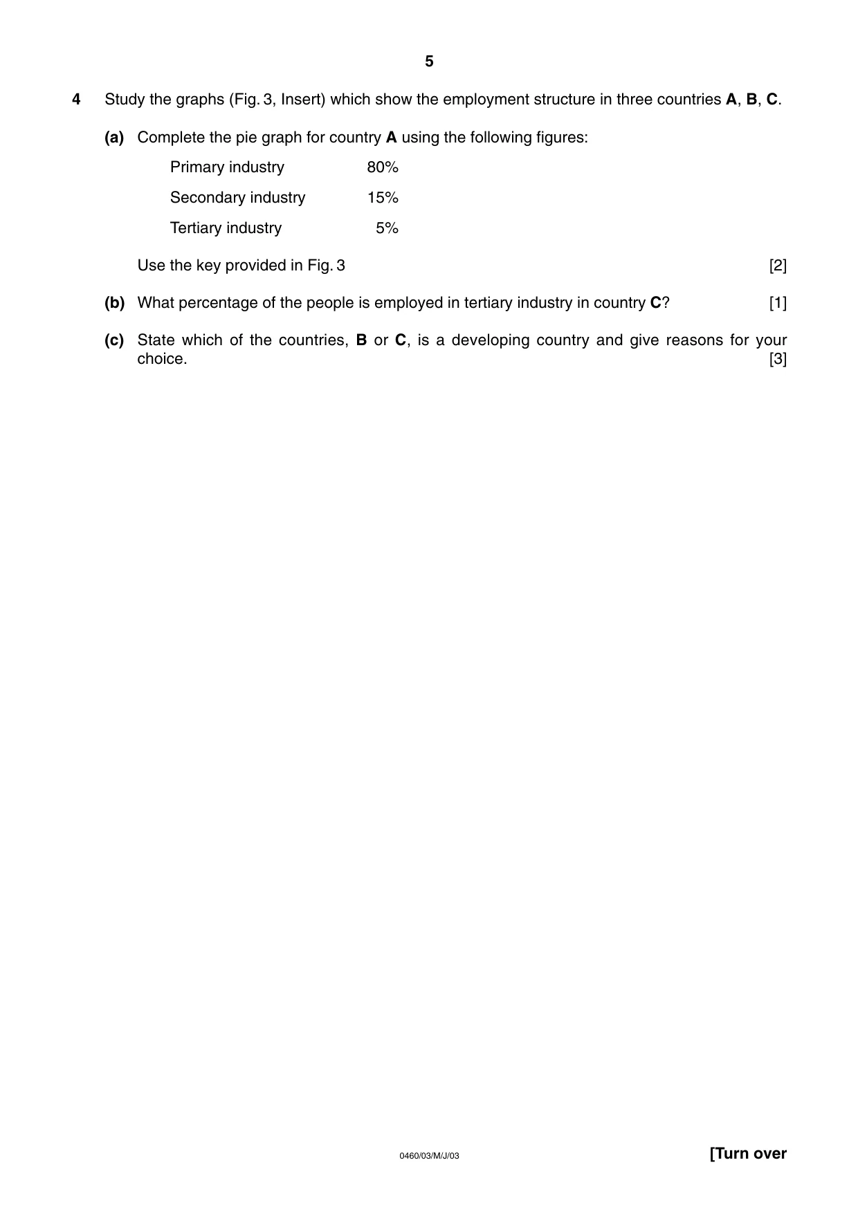
4 Study the graphs (Fig. 3, Insert) which show the employment structure in three countries A, B, C. (a) Complete the pie graph for country A using the following figures: Primary industry 80% Secondary industry 15% Tertiary industry 5% Use the key provided in Fig. 3 [2] (b) What percentage of the people is employed in tertiary industry in country C? [1] (c) State which of the countries, B or C, is a developing country and give reasons for your choice. [3] 5 [Turn over 0460/03/M/J/03
Question paper, page 6
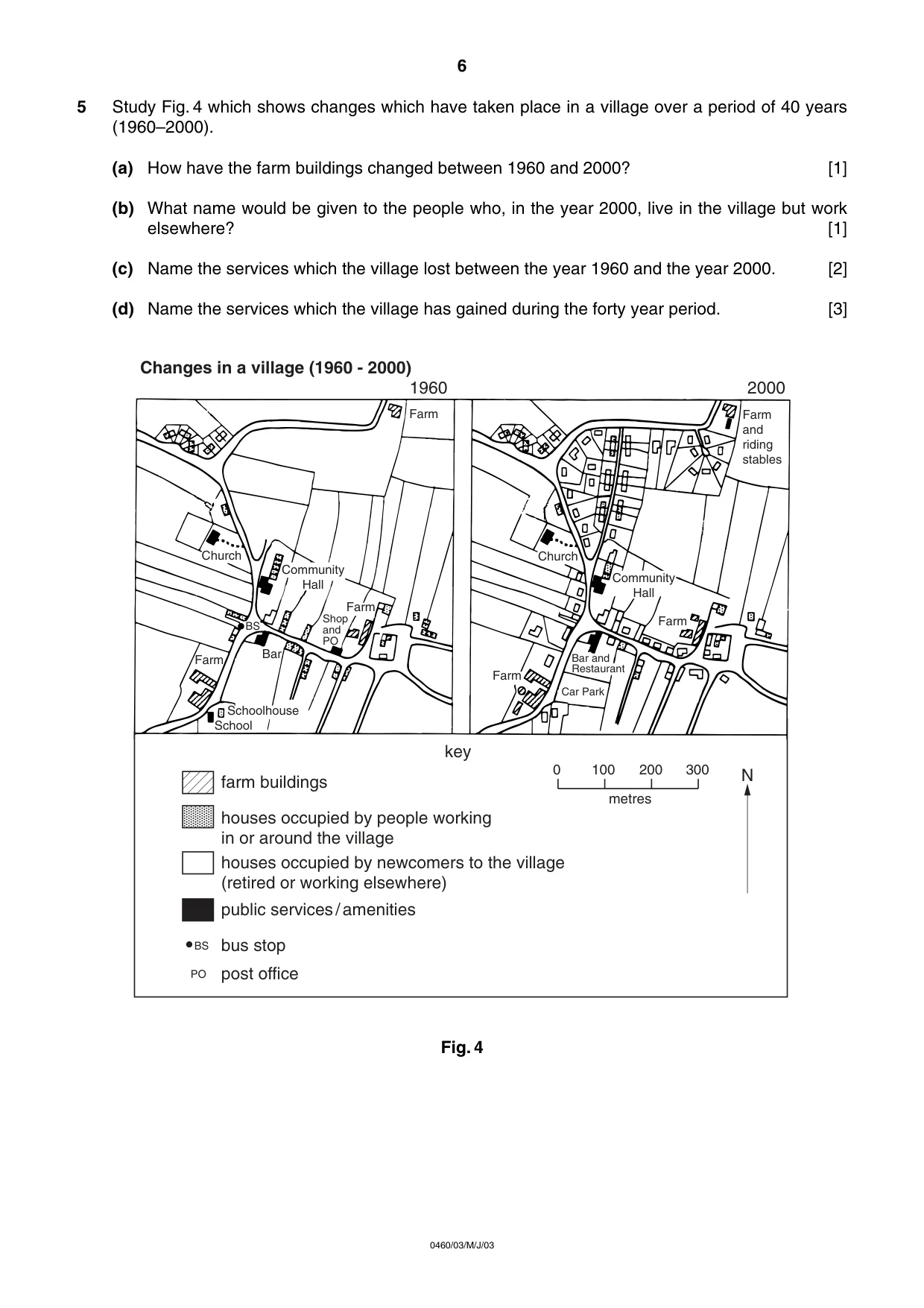
5 Study Fig. 4 which shows changes which have taken place in a village over a period of 40 years (1960–2000). (a) How have the farm buildings changed between 1960 and 2000? [1] (b) What name would be given to the people who, in the year 2000, live in the village but work elsewhere? [1] (c) Name the services which the village lost between the year 1960 and the year 2000. [2] (d) Name the services which the village has gained during the forty year period. [3] Fig. 4 Farm Farm and riding stables Farm Farm Car Park Church Church Farm Farm Schoolhouse School Bar Bar and Restaurant Shop and PO BS BS PO Community Hall Community Hall farm buildings key 1960 N houses occupied by people working in or around the village houses occupied by newcomers to the village (retired or working elsewhere) public services/amenities bus stop post office 0 100 200 300 metres 2000 Changes in a village (1960 - 2000) 6 0460/03/M/J/03
Question paper, page 7
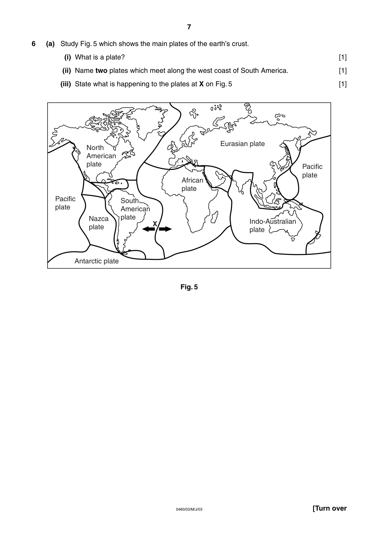
6 (a) Study Fig. 5 which shows the main plates of the earth’s crust. (i) What is a plate? [1] (ii) Name two plates which meet along the west coast of South America. [1] (iii) State what is happening to the plates at X on Fig. 5 [1] Fig. 5 North American plate Pacific plate Pacific plate Nazca plate Antarctic plate South American plate South American plate African plate Eurasian plate Indo-Australian plate Indo-Australian plate X 7 [Turn over 0460/03/M/J/03
Question paper, page 8
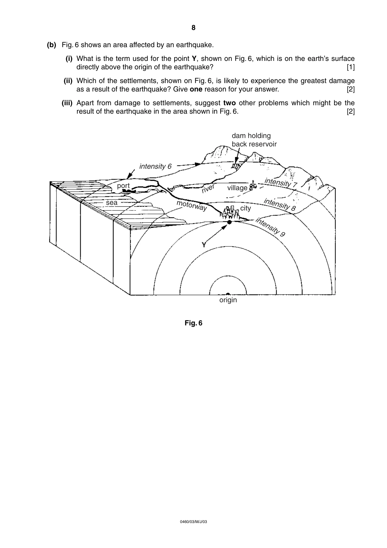
(b) Fig. 6 shows an area affected by an earthquake. (i) What is the term used for the point Y, shown on Fig. 6, which is on the earth’s surface directly above the origin of the earthquake? [1] (ii) Which of the settlements, shown on Fig. 6, is likely to experience the greatest damage as a result of the earthquake? Give one reason for your answer. [2] (iii) Apart from damage to settlements, suggest two other problems which might be the result of the earthquake in the area shown in Fig. 6. [2] Fig. 6 origin Y intensity 6 intensity 7 intensity 8 intensity 9 city village dam holding back reservoir port sea motorway river 8 0460/03/M/J/03
Question paper, page 9
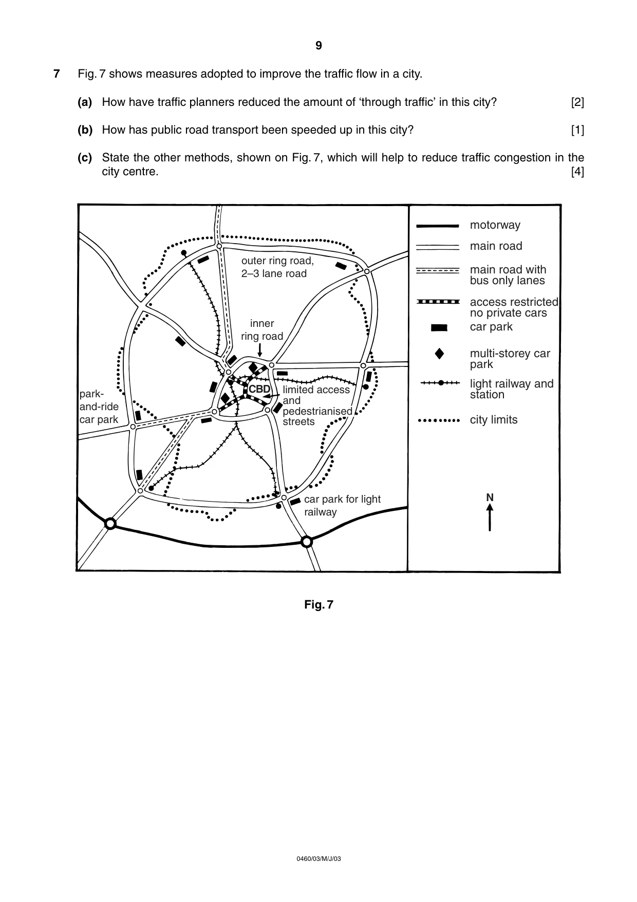
7 Fig. 7 shows measures adopted to improve the traffic flow in a city. (a) How have traffic planners reduced the amount of ‘through traffic’ in this city? [2] (b) How has public road transport been speeded up in this city? [1] (c) State the other methods, shown on Fig. 7, which will help to reduce traffic congestion in the city centre. [4] Fig. 7 outer ring road, 2–3 lane road inner ring road park- and-ride car park car park for light railway CBD motorway main road main road with bus only lanes access restricted, no private cars car park multi-storey car park light railway and station city limits N limited access and pedestrianised streets 9 0460/03/M/J/03
Question paper, page 12
BLANK PAGE 0460/03 June 2003 Copyright Acknowledgements Cambridge International Examinations has made every effort to trace copyright holders, but if we have inadvertently overlooked any we will be pleased to make the necessary arrangements at the first opportunity. 12 0460/03/M/J/03