Cambridge IGCSE Geography 0460 — 2002 Oct/Nov Paper 3 · Variant 1
0460/31/O/N/02
The question paper and its mark scheme, free to read here and free to download. This is Cambridge’s own paper, exactly as it was sat.
Question paper12 pages



Mark scheme3 pages
Answers below. Sit the paper first if you are practising.
Paper as text
Question paper, page 1
TIME 1 hour 30 minutes INSTRUCTIONS TO CANDIDATES Write your name, Centre number and candidate number in the spaces provided on the answer paper/answer booklet. Answer all questions. Write your answers on the separate answer paper provided. If you use more than one sheet of paper, fasten the sheets together. INFORMATION FOR CANDIDATES The number of marks is given in brackets [ ] at the end of each question or part question. Sketch-maps and diagrams should be drawn whenever they serve to illustrate an answer. The insert contains the diagrams referred to in the question paper. This question paper consists of 10 printed pages, 2 blank pages, an insert and a survey map. MML 1409 4/01 S16047/1 © UCLES 2002 [Turn over International General Certificate of Secondary Education CAMBRIDGE INTERNATIONAL EXAMINATIONS GEOGRAPHY 0460/3 PAPER 3 OCTOBER/NOVEMBER SESSION 2002 1 hour 30 minutes Additional materials: Answer paper Protractor Ruler Set square 1:50 000 survey map is enclosed with this question paper. UNIVERSITY of CAMBRIDGE Local Examinations Syndicate www.XtremePapers.com
Question paper, page 2
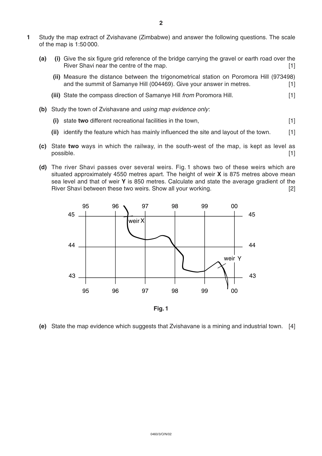
1 Study the map extract of Zvishavane (Zimbabwe) and answer the following questions. The scale of the map is 1:50 000. (a) (i) Give the six figure grid reference of the bridge carrying the gravel or earth road over the River Shavi near the centre of the map. [1] (ii) Measure the distance between the trigonometrical station on Poromora Hill (973498) and the summit of Samanye Hill (004469). Give your answer in metres. [1] (iii) State the compass direction of Samanye Hill from Poromora Hill. [1] (b) Study the town of Zvishavane and using map evidence only: (i) state two different recreational facilities in the town, [1] (ii) identify the feature which has mainly influenced the site and layout of the town. [1] (c) State two ways in which the railway, in the south-west of the map, is kept as level as possible. [1] (d) The river Shavi passes over several weirs. Fig. 1 shows two of these weirs which are situated approximately 4550 metres apart. The height of weir X is 875 metres above mean sea level and that of weir Y is 850 metres. Calculate and state the average gradient of the River Shavi between these two weirs. Show all your working. [2] Fig. 1 (e) State the map evidence which suggests that Zvishavane is a mining and industrial town. [4] 95 96 97 98 99 00 95 96 97 98 99 00 45 44 43 45 44 43 weir weir X Y 2 0460/3/O/N/02
Question paper, page 3
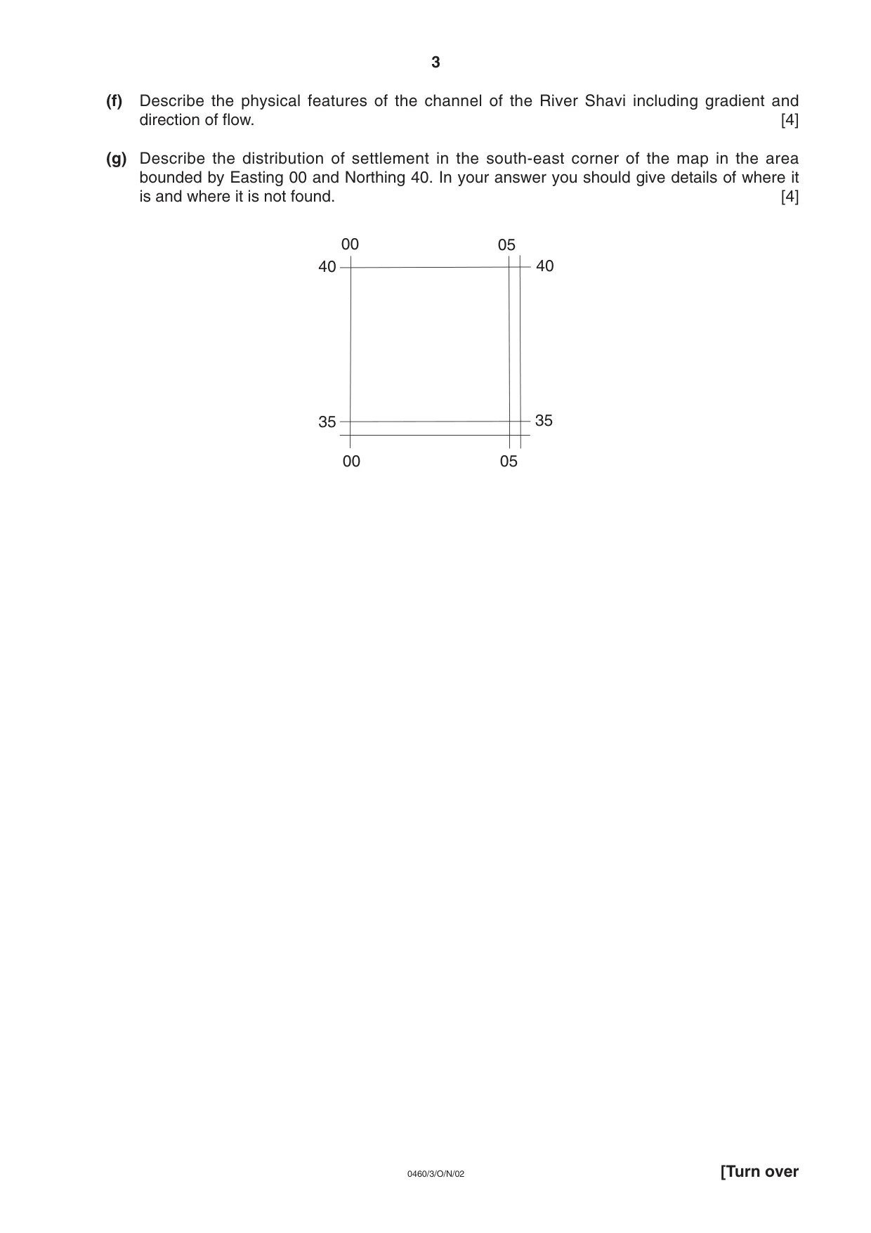
(f) Describe the physical features of the channel of the River Shavi including gradient and direction of flow. [4] (g) Describe the distribution of settlement in the south-east corner of the map in the area bounded by Easting 00 and Northing 40. In your answer you should give details of where it is and where it is not found. [4] 05 00 05 00 35 40 35 40 3 [Turn over 0460/3/O/N/02
Question paper, page 4
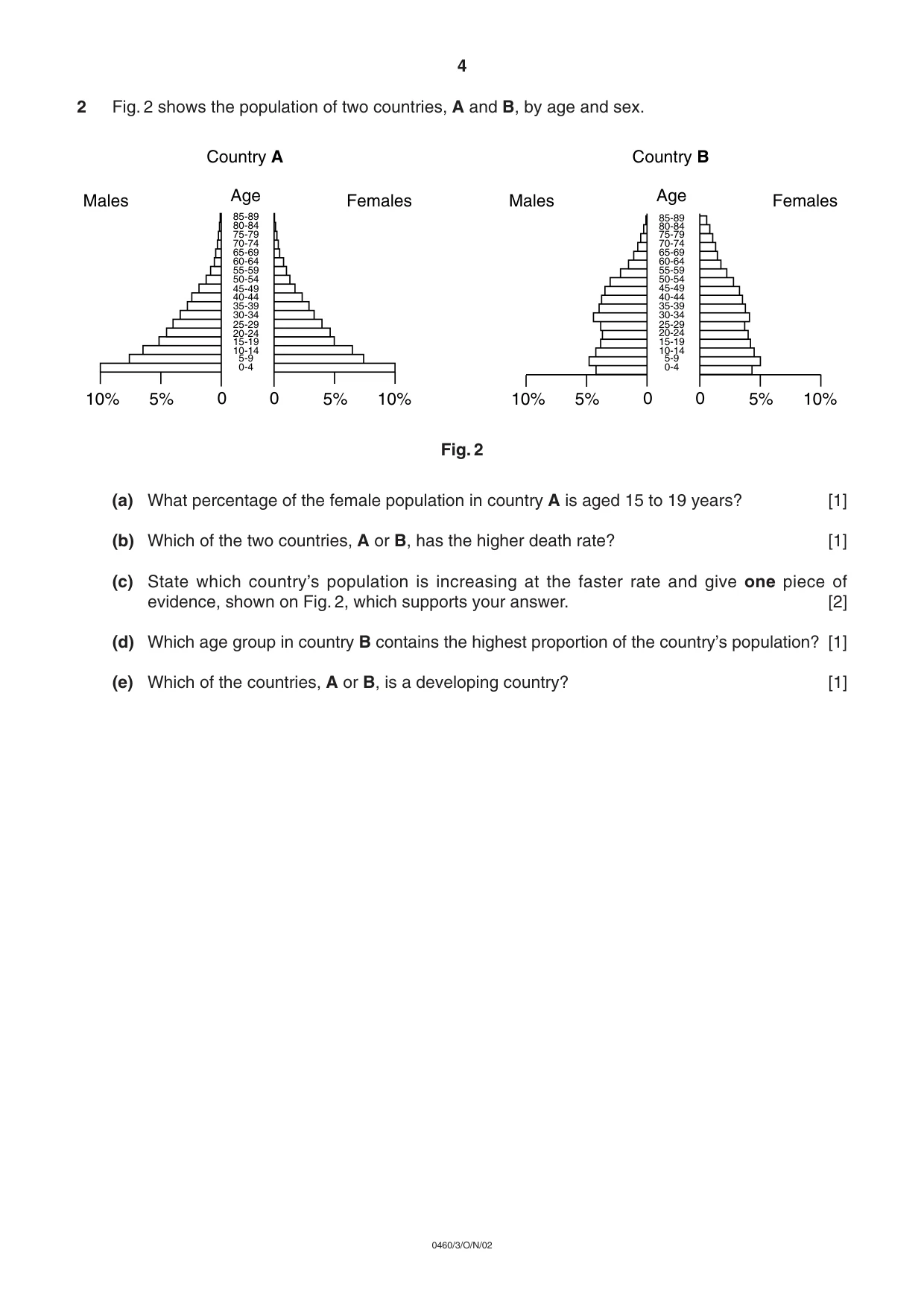
2 Fig. 2 shows the population of two countries, A and B, by age and sex. Fig. 2 (a) What percentage of the female population in country A is aged 15 to 19 years? [1] (b) Which of the two countries, A or B, has the higher death rate? [1] (c) State which country’s population is increasing at the faster rate and give one piece of evidence, shown on Fig. 2, which supports your answer. [2] (d) Which age group in country B contains the highest proportion of the country’s population? [1] (e) Which of the countries, A or B, is a developing country? [1] 10% 10% 5% 5% 0 0 85-89 80-84 75-79 70-74 65-69 60-64 55-59 50-54 45-49 40-44 35-39 30-34 25-29 20-24 15-19 10-14 5-9 0-4 Age Males Females Country A 10% 10% 5% 5% 0 0 85-89 80-84 75-79 70-74 65-69 60-64 55-59 50-54 45-49 40-44 35-39 30-34 25-29 20-24 15-19 10-14 5-9 0-4 Age Males Females Country B 4 0460/3/O/N/02
Question paper, page 5
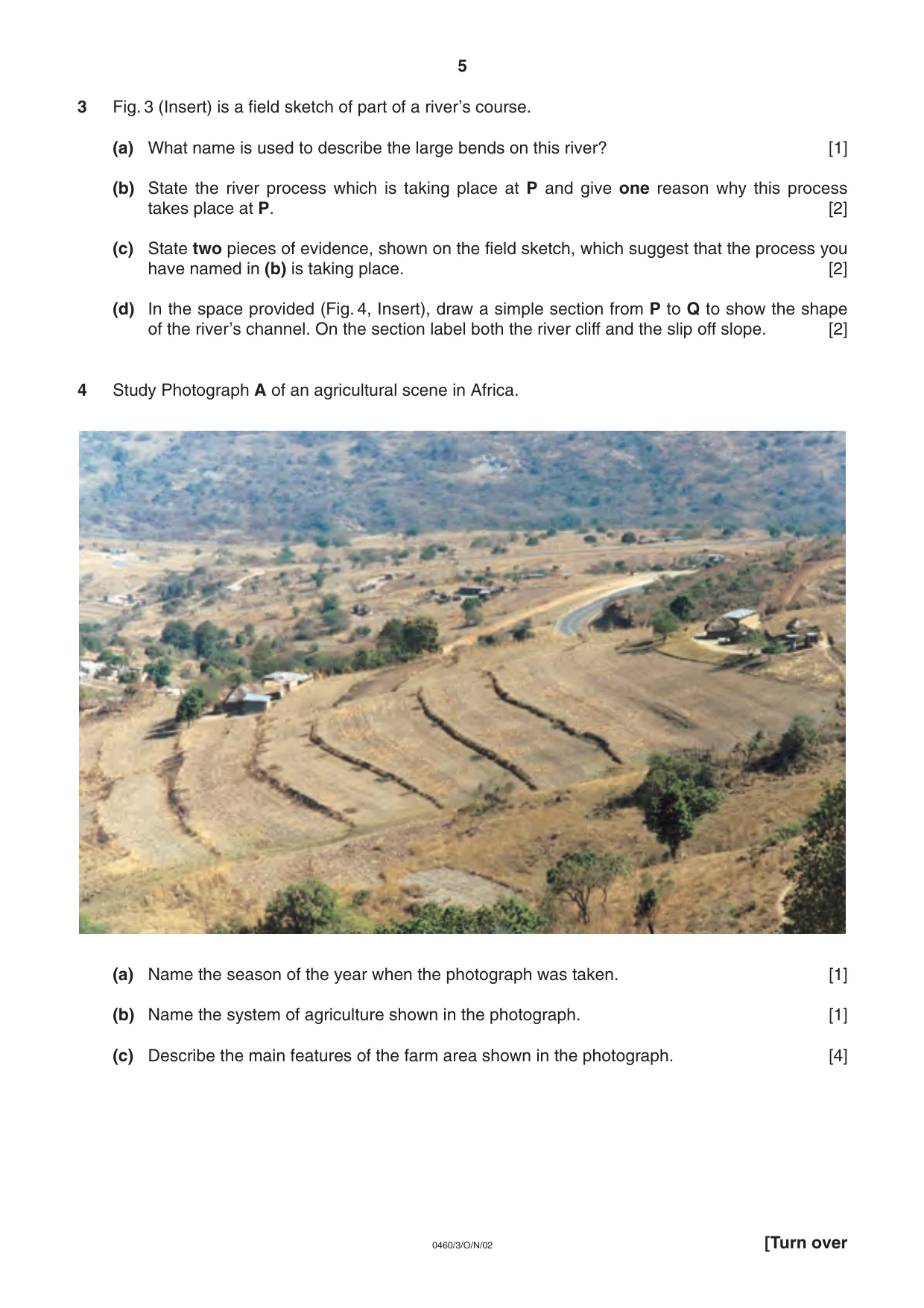
3 Fig. 3 (Insert) is a field sketch of part of a river’s course. (a) What name is used to describe the large bends on this river? [1] (b) State the river process which is taking place at P and give one reason why this process takes place at P. [2] (c) State two pieces of evidence, shown on the field sketch, which suggest that the process you have named in (b) is taking place. [2] (d) In the space provided (Fig. 4, Insert), draw a simple section from P to Q to show the shape of the river’s channel. On the section label both the river cliff and the slip off slope. [2] 4 Study Photograph A of an agricultural scene in Africa. (a) Name the season of the year when the photograph was taken. [1] (b) Name the system of agriculture shown in the photograph. [1] (c) Describe the main features of the farm area shown in the photograph. [4] 5 [Turn over 0460/3/O/N/02
Question paper, page 6
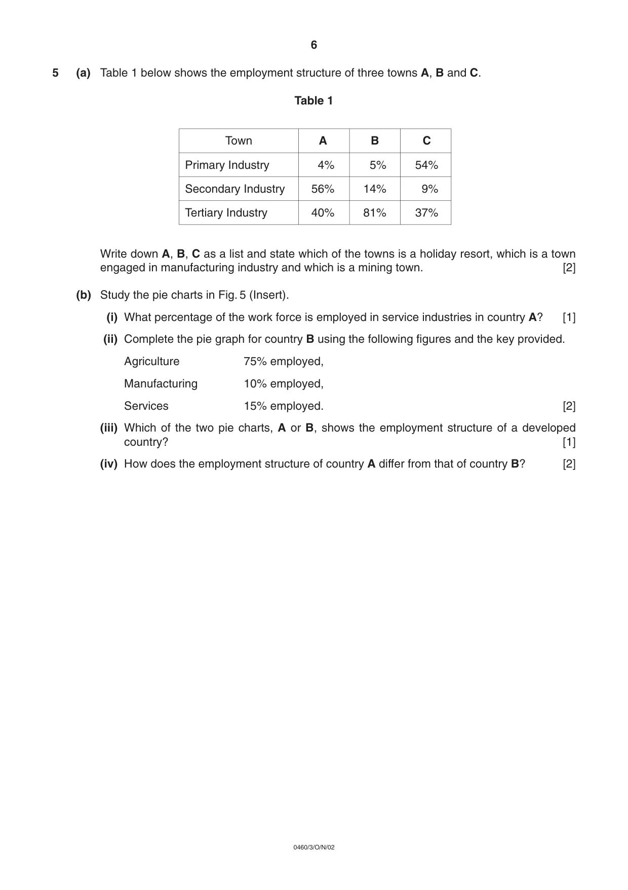
5 (a) Table 1 below shows the employment structure of three towns A, B and C. Table 1 Write down A, B, C as a list and state which of the towns is a holiday resort, which is a town engaged in manufacturing industry and which is a mining town. [2] (b) Study the pie charts in Fig. 5 (Insert). (i) What percentage of the work force is employed in service industries in country A? [1] (ii) Complete the pie graph for country B using the following figures and the key provided. Agriculture 75% employed, Manufacturing 10% employed, Services 15% employed. [2] (iii) Which of the two pie charts, A or B, shows the employment structure of a developed country? [1] (iv) How does the employment structure of country A differ from that of country B? [2] 6 0460/3/O/N/02 Town A B C 4% 5% 54% 56% 14% 9% 40% 81% 37% Primary Industry Secondary Industry Tertiary Industry
Question paper, page 8
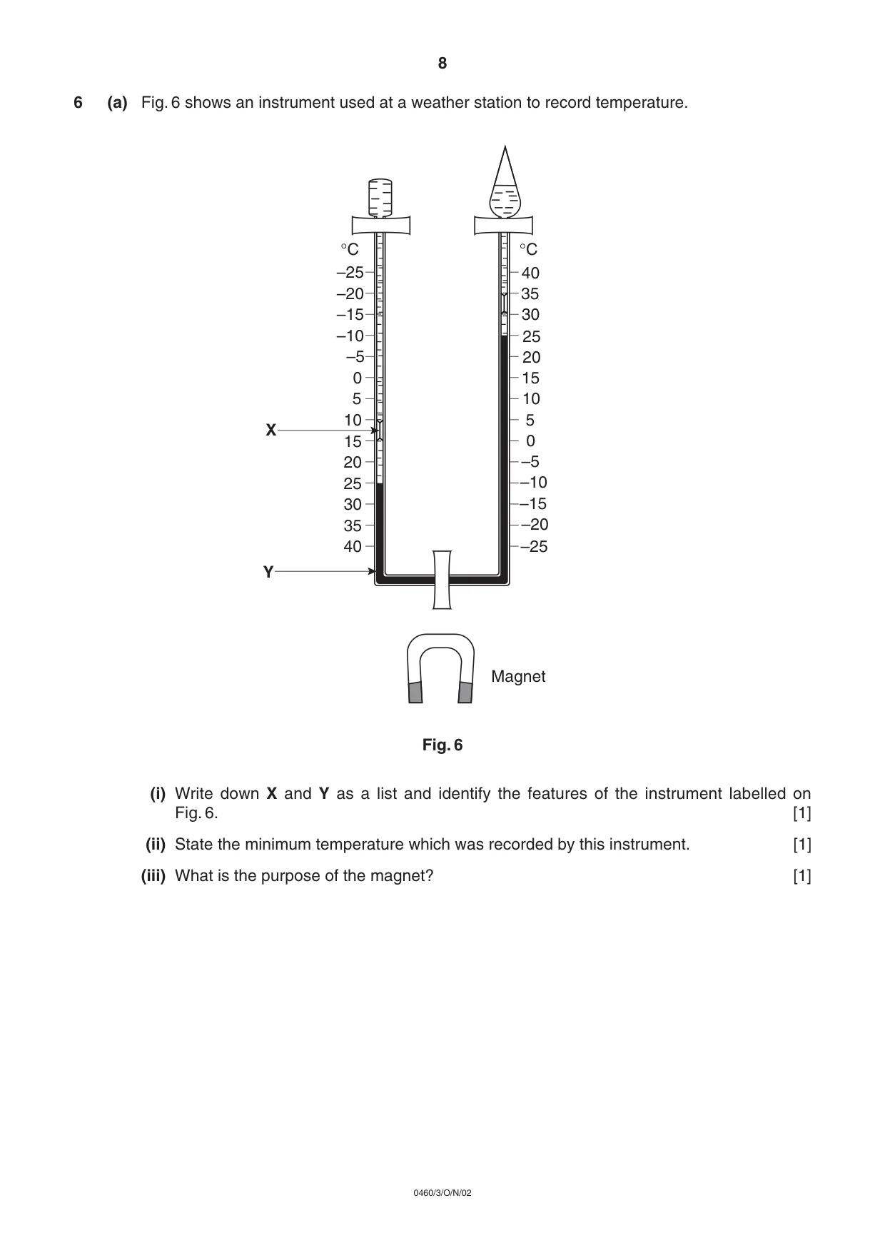
6 (a) Fig. 6 shows an instrument used at a weather station to record temperature. Fig. 6 (i) Write down X and Y as a list and identify the features of the instrument labelled on Fig. 6. [1] (ii) State the minimum temperature which was recorded by this instrument. [1] (iii) What is the purpose of the magnet? [1] 40 40 35 35 30 30 25 25 20 20 15 15 10 10 5 5 0 0 –5 –5 –10 –10 –15 –15 –20 –20 –25 –25 Magnet X Y °C °C 8 0460/3/O/N/02
Question paper, page 9
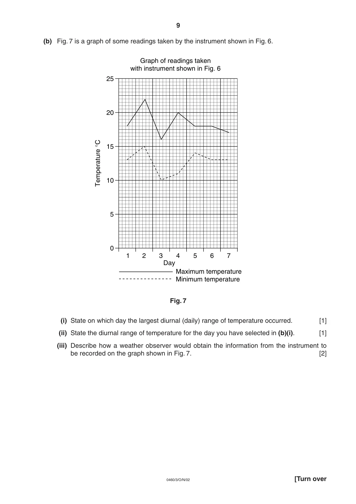
(b) Fig. 7 is a graph of some readings taken by the instrument shown in Fig. 6. Fig. 7 (i) State on which day the largest diurnal (daily) range of temperature occurred. [1] (ii) State the diurnal range of temperature for the day you have selected in (b)(i). [1] (iii) Describe how a weather observer would obtain the information from the instrument to be recorded on the graph shown in Fig. 7. [2] 6 4 2 1 3 5 7 0 5 10 15 20 25 Day Maximum temperature Minimum temperature Temperature °C Graph of readings taken with instrument shown in Fig. 6 9 [Turn over 0460/3/O/N/02
Question paper, page 10
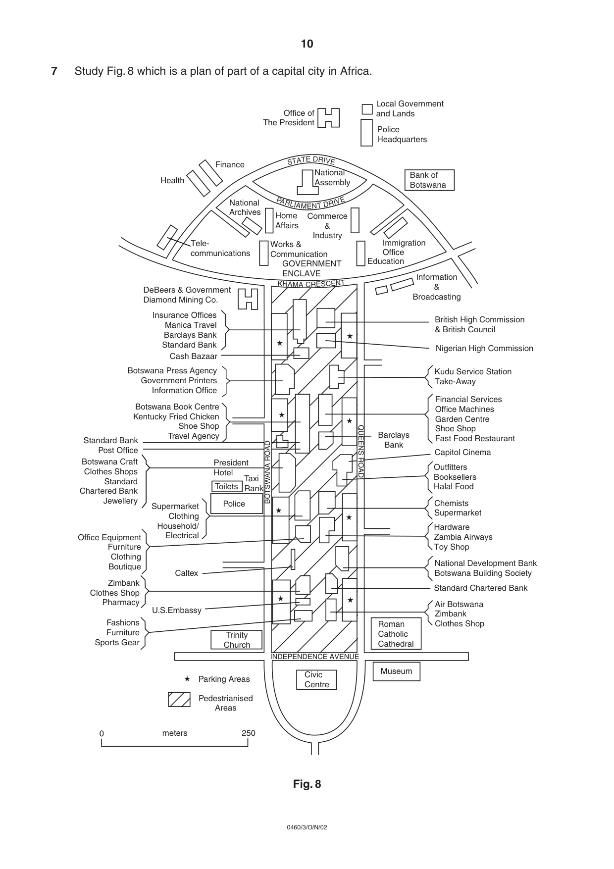
7 Study Fig. 8 which is a plan of part of a capital city in Africa. Fig. 8 PARL I A M E N T DR IV E ★ ★ ★ ★ ★ ★ ★ ★ ★ Office of The President Local Government and Lands Police Headquarters Bank of Botswana National Assembly Finance Health National Archives Home Affairs Commerce & Industry Works & Communication Immigration Office Education Information & Broadcasting Tele- communications GOVERNMENT ENCLAVE 0 meters 250 British High Commission & British Council Nigerian High Commission Kudu Service Station Take-Away Financial Services Office Machines Garden Centre Shoe Shop Fast Food Restaurant Capitol Cinema Outfitters Booksellers Halal Food Chemists Supermarket Hardware Zambia Airways Toy Shop National Development Bank Botswana Building Society Standard Chartered Bank Air Botswana Zimbank Clothes Shop Roman Catholic Cathedral Museum Civic Centre INDEPENDENCE AVENUE S T A T E D R IV E DeBeers & Government Diamond Mining Co. Insurance Offices Manica Travel Barclays Bank Standard Bank Cash Bazaar Botswana Press Agency Government Printers Information Office Botswana Book Centre Kentucky Fried Chicken Shoe Shop Travel Agency Standard Bank Post Office Botswana Craft Clothes Shops Standard Chartered Bank Jewellery President Hotel Taxi Rank Toilets Police Supermarket Clothing Household/ Electrical Office Equipment Furniture Clothing Boutique Zimbank Clothes Shop Pharmacy Fashions Furniture Sports Gear U.S.Embassy Caltex Trinity Church Parking Areas Pedestrianised Areas Barclays Bank QUEENS ROAD BOTSWANA ROAD KHA MA CRESCE NT 10 0460/3/O/N/02
Question paper, page 11
(a) Using evidence from Fig. 8 only, describe what has been done to solve the problem of traffic congestion in this part of the city. [2] (b) Describe, in your own words, the evidence which suggests that the area shown in the plan is the CBD of this city. [4] 11 0460/3/O/N/02
Question paper, page 12
BLANK PAGE 0460/3 November 2002 Copyright Acknowledgements: Question 4. Agriculture scene in Africa. © Mr R F Sharpe Question 7 Fig 8. Margaret Mackintosh. Primary Georgrapher. © Geographical Association. Cambridge International Examinations has made every effort to trace the copyright holders, but if we have inadvertently overlooked any we will be pleased to make the necessary arrangements at the first opportunity. 12 0460/3/O/N/02
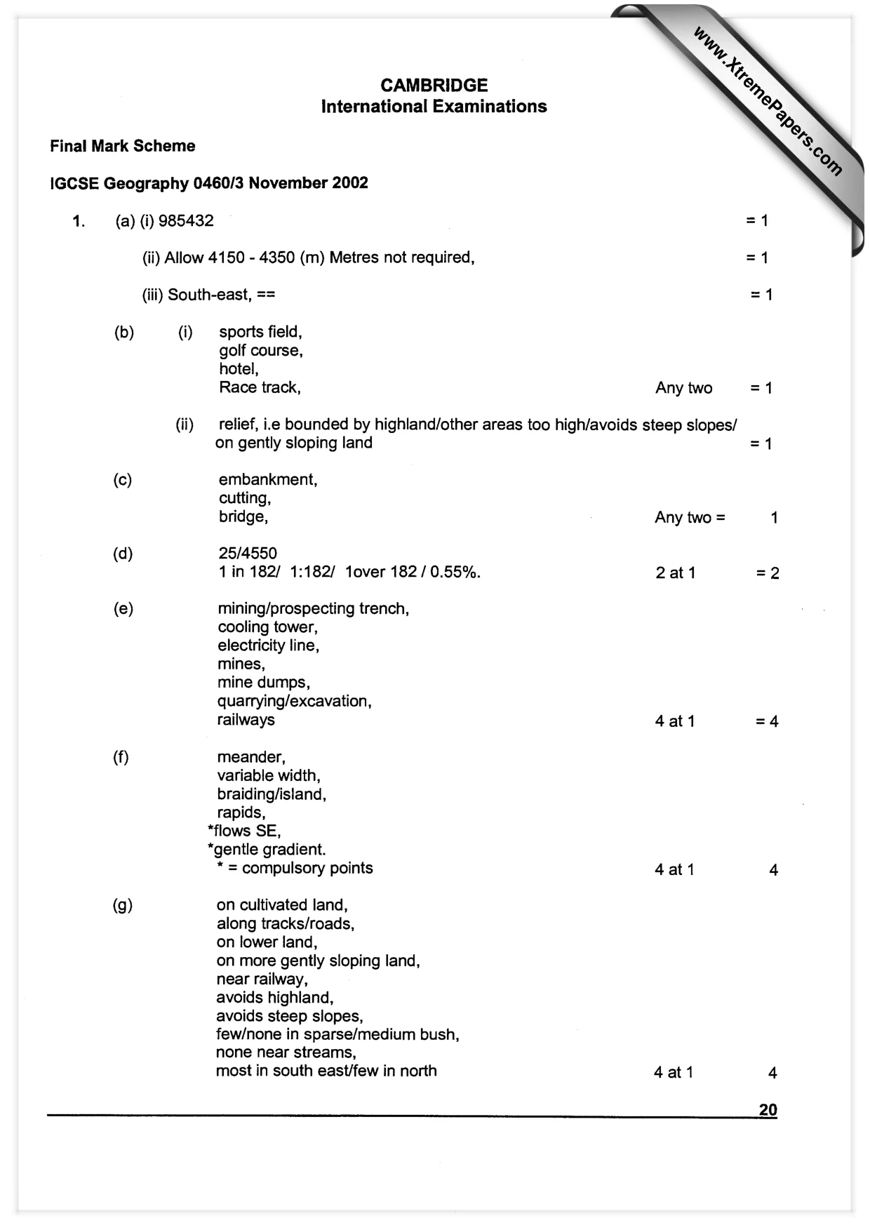
Mark scheme, page 1
CAMBRIDGE International Examinations Final Mark Scheme IGCSE Geography 0460/3 November 2002 14. (a) (i) 985432 (ii) Allow 4150 - 4350 (m) Metres not required, (iii) South-east, == =1 (b) (i) sports field, golf course, hotel, Race track, Any two =1 (ii) relief, ite bounded by highland/other areas too high/avoids steep slopes/ on gently sloping land =1 (c) embankment, cutting, bridge, Any two = 1 (d) 25/4550 1 in 182/ 1:182/ tover 182/0.55%. 2at1 =2 (e) mining/prospecting trench, cooling tower, electricity line, mines, mine dumps, quarrying/excavation, railways 4at1 =4 (f) meander, variable width, braiding/island, rapids, *flows SE, *gentle gradient. * = compulsory points 4at1 4 (g) on cultivated land, along tracks/roads, on lower land, on more gently sloping land, near railway, avoids highland, avoids steep slopes, few/none in sparse/medium bush, none near streams, most in south east/few in north 4at1 4 20
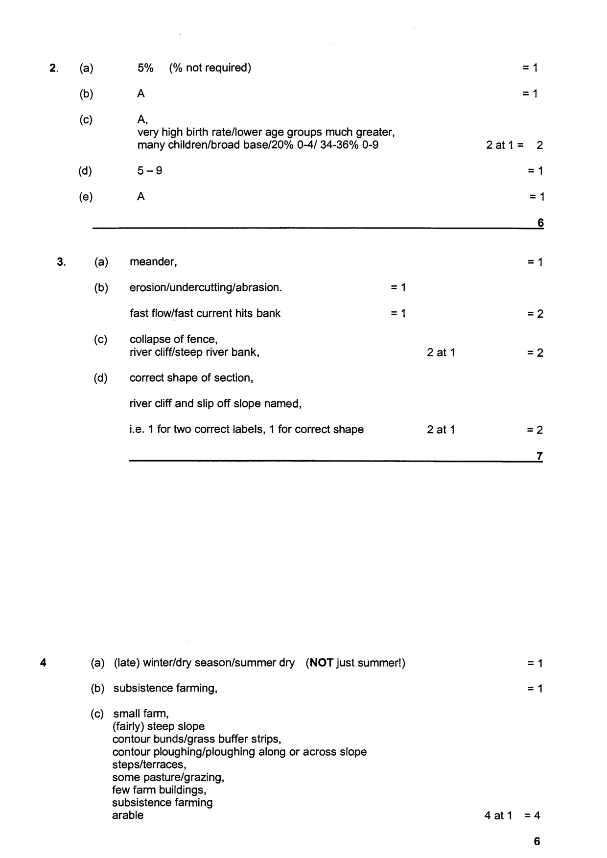
Mark scheme, page 2
4 (a) (b) (c) (d) (e) 5% (% not required) =1 A =1 A, very high birth rate/lower age groups much greater, many children/broad base/20% 0-4/ 34-36% 0-9 2at1= 2 5-9 =1 A =1 6 (a) meander, =1 (b) _ erosion/undercutting/abrasion. =1 fast flow/fast current hits bank =1 =2 (c) collapse of fence, river cliff/steep river bank, 2at1 =2 (d) correct shape of section, river cliff and slip off slope named, i.e. 1 for two correct labels, 1 for correct shape 2at1 =2 Z (a) (late) winter/dry season/summer dry (NOT just summer!) =1 (b) subsistence farming, =1 (c) small farm, (fairly) steep slope contour bunds/grass buffer strips, contour ploughing/ploughing along or across slope steps/terraces, some pasture/grazing, few farm buildings, subsistence farming arable 4at1 =4
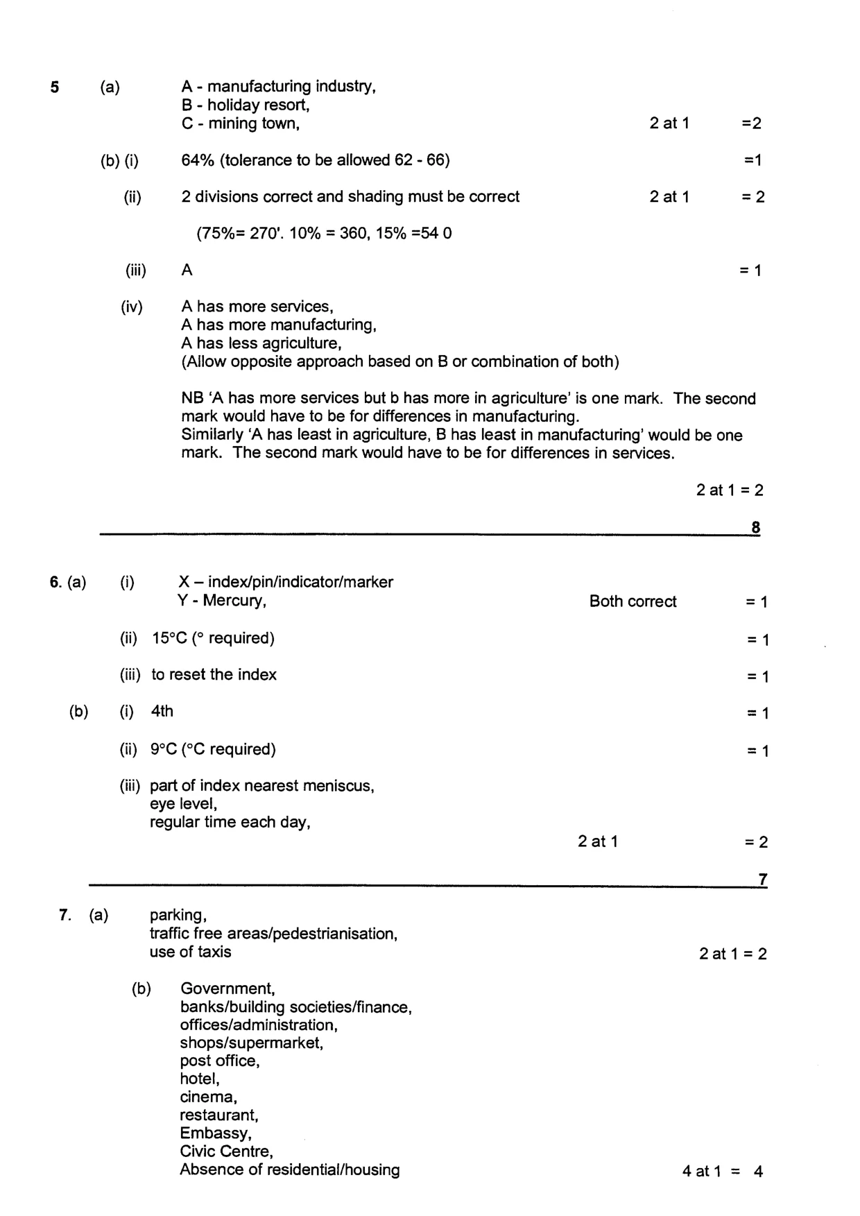
Mark scheme, page 3
5 (a) A- manufacturing industry, B - holiday resort, C - mining town, 2at1 =2 (b) (i) 64% (tolerance to be allowed 62 - 66) =1 (ii) 2 divisions correct and shading must be correct 2at1 =2 (75%= 270'. 10% = 360, 15% =54 0 (i) A =4 (iv) A has more services, A has more manufacturing, A has less agriculture, (Allow opposite approach based on B or combination of both) NB ‘A has more services but b has more in agriculture’ is one mark. The second mark would have to be for differences in manufacturing. Similarly ‘A has least in agriculture, B has least in manufacturing’ would be one mark. The second mark would have to be for differences in services. 2at1=2 8 6. (a) (i) X — index/pin/indicator/marker Y - Mercury, Both correct =1 (ii) 15°C (° required) =1 (iii) to reset the index =1 (b) (i) 4th =1 (ii) 9°C (°C required) =1 (iii) part of index nearest meniscus, eye level, regular time each day, 2at1 =2 7 7. (a) parking, traffic free areas/pedestrianisation, use of taxis 2at1=2 (b) Government, banks/building societies/finance, offices/administration, shops/supermarket, post office, hotel, cinema, restaurant, Embassy, Civic Centre, Absence of residential/housing 4at1= 4