Cambridge IGCSE Environmental Management 0680 — 2018 Oct/Nov Paper 1 · Variant 3
0680/13/O/N/18 · 60 marks · ≈68 min
The question paper and its mark scheme, free to read here and free to download. This is Cambridge’s own paper, exactly as it was sat.
Question paper16 pages

Mark scheme10 pages
Answers below. Sit the paper first if you are practising.
Paper as text
Question paper, page 1
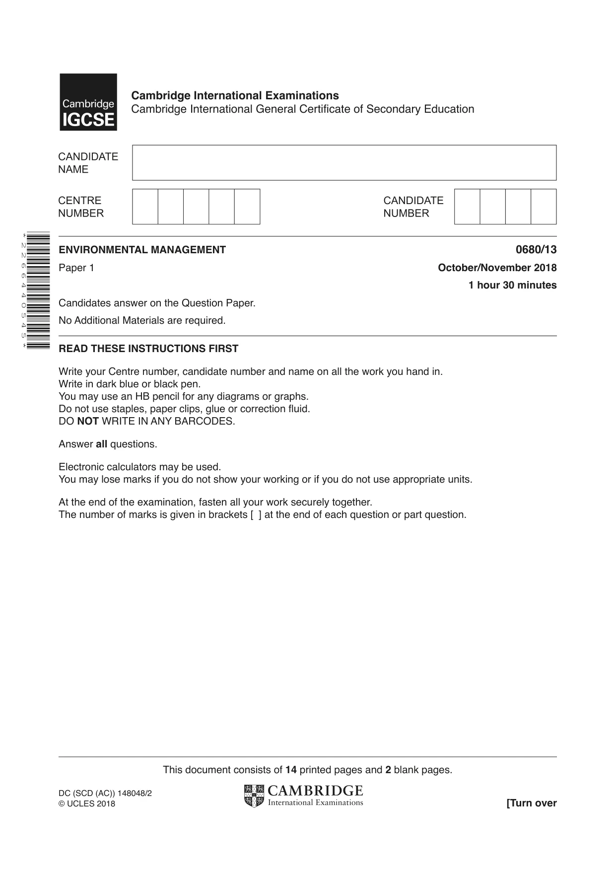
This document consists of 14 printed pages and 2 blank pages. DC (SCD (AC)) 148048/2 © UCLES 2018 [Turn over * 2 2 6 6 4 4 0 5 4 5 * ENVIRONMENTAL MANAGEMENT 0680/13 Paper 1 October/November 2018 1 hour 30 minutes Candidates answer on the Question Paper. No Additional Materials are required. READ THESE INSTRUCTIONS FIRST Write your Centre number, candidate number and name on all the work you hand in. Write in dark blue or black pen. You may use an HB pencil for any diagrams or graphs. Do not use staples, paper clips, glue or correction fluid. DO NOT WRITE IN ANY BARCODES. Answer all questions. Electronic calculators may be used. You may lose marks if you do not show your working or if you do not use appropriate units. At the end of the examination, fasten all your work securely together. The number of marks is given in brackets [ ] at the end of each question or part question. Cambridge International Examinations Cambridge International General Certificate of Secondary Education
Question paper, page 2
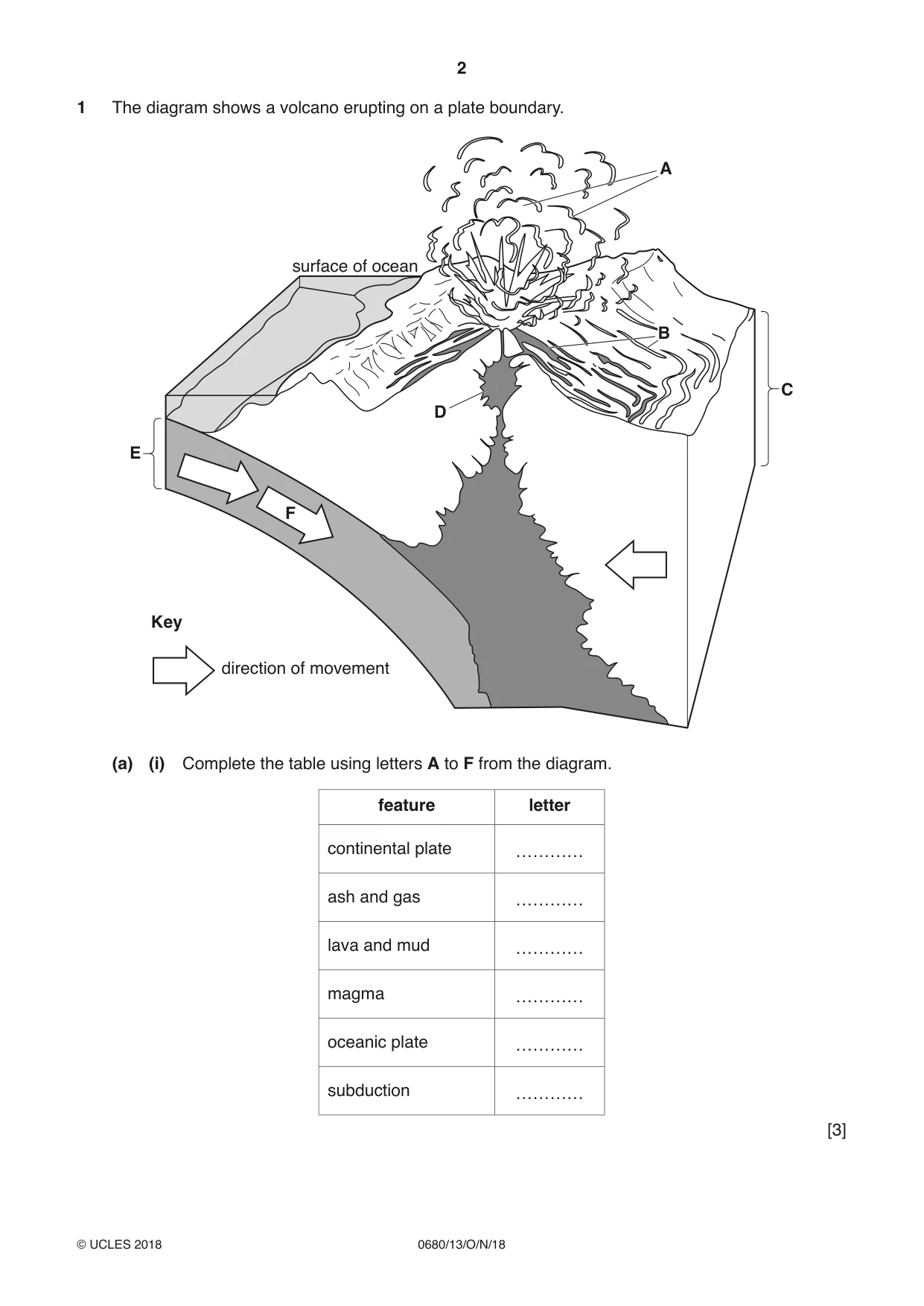
2 0680/13/O/N/18 © UCLES 2018 1 The diagram shows a volcano erupting on a plate boundary. surface of ocean direction of movement Key A C D E F B (a) (i) Complete the table using letters A to F from the diagram. feature letter continental plate ………… ash and gas ………… lava and mud ………… magma ………… oceanic plate ………… subduction ………… [3]
Question paper, page 3
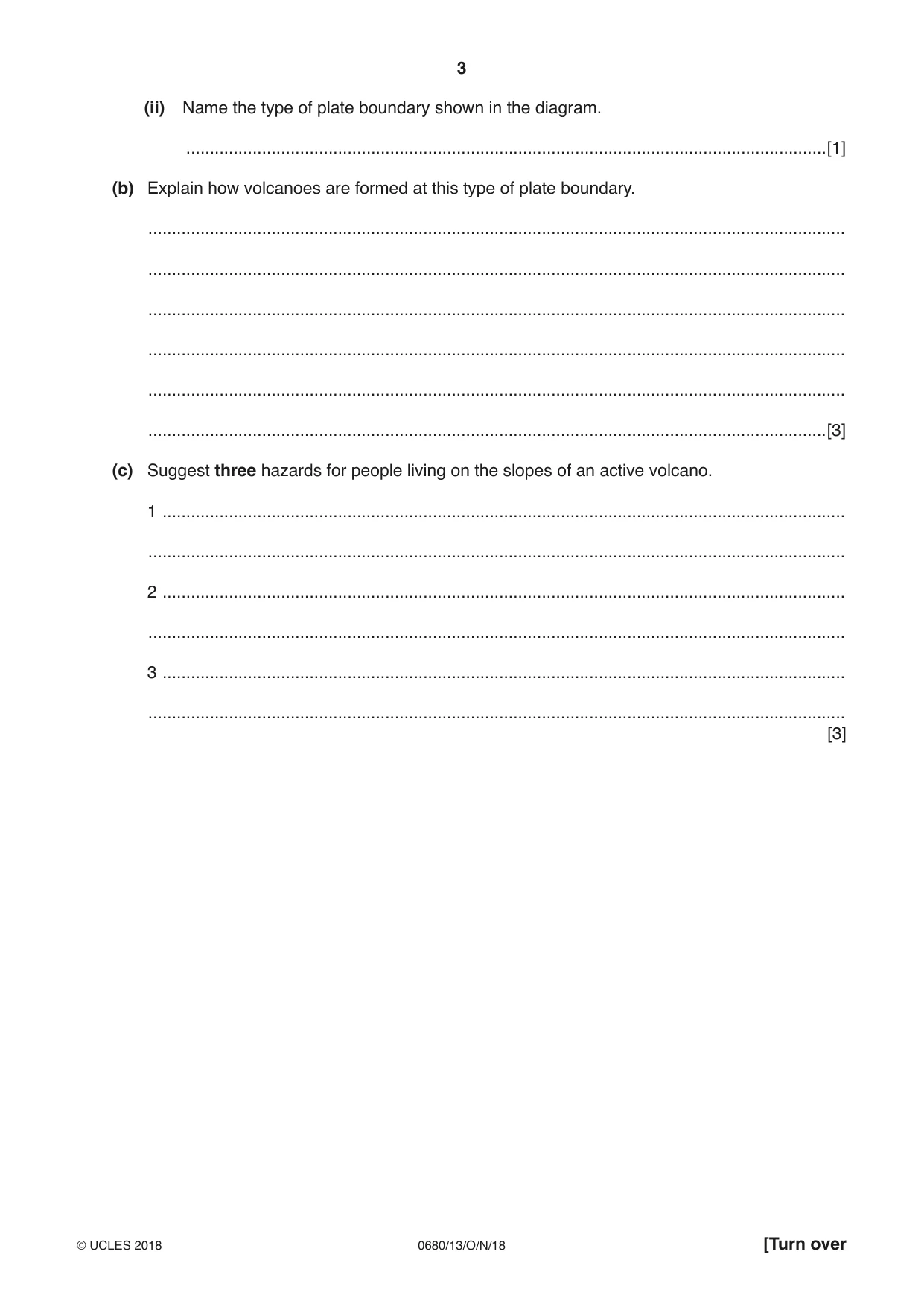
3 0680/13/O/N/18 © UCLES 2018 [Turn over (ii) Name the type of plate boundary shown in the diagram. …[1] (b) Explain how volcanoes are formed at this type of plate boundary. … … … … … …[3] (c) Suggest three hazards for people living on the slopes of an active volcano. 1 … … 2 … … 3 … … [3]
Question paper, page 4
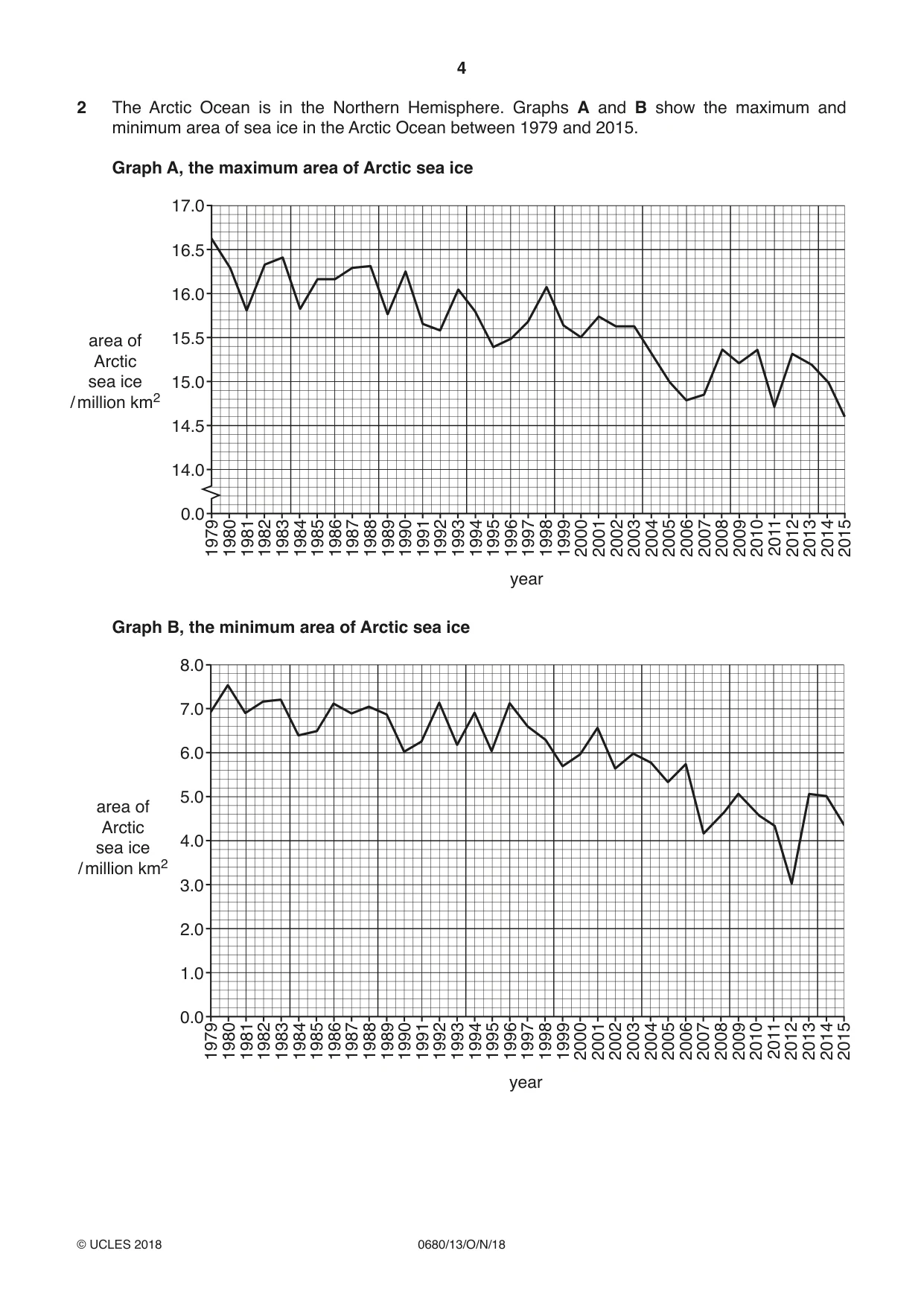
4 0680/13/O/N/18 © UCLES 2018 2 The Arctic Ocean is in the Northern Hemisphere. Graphs A and B show the maximum and minimum area of sea ice in the Arctic Ocean between 1979 and 2015. Graph A, the maximum area of Arctic sea ice 1979 1980 1981 1982 1983 1984 1985 1986 1987 1988 1989 1990 1991 1992 1993 1994 1995 1996 1997 1998 1999 2000 2001 2002 2003 2004 2005 2006 2007 2008 2009 2010 2011 2012 2013 2014 2015 0.0 year 14.0 14.5 15.0 15.5 area of Arctic sea ice / million km2 16.0 16.5 17.0 Graph B, the minimum area of Arctic sea ice 1979 1980 1981 1982 1983 1984 1985 1986 1987 1988 1989 1990 1991 1992 1993 1994 1995 1996 1997 1998 1999 2000 2001 2002 2003 2004 2005 2006 2007 2008 2009 2010 2011 2012 2013 2014 2015 0.0 year 1.0 2.0 3.0 4.0 area of Arctic sea ice / million km2 5.0 6.0 7.0 8.0
Question paper, page 5
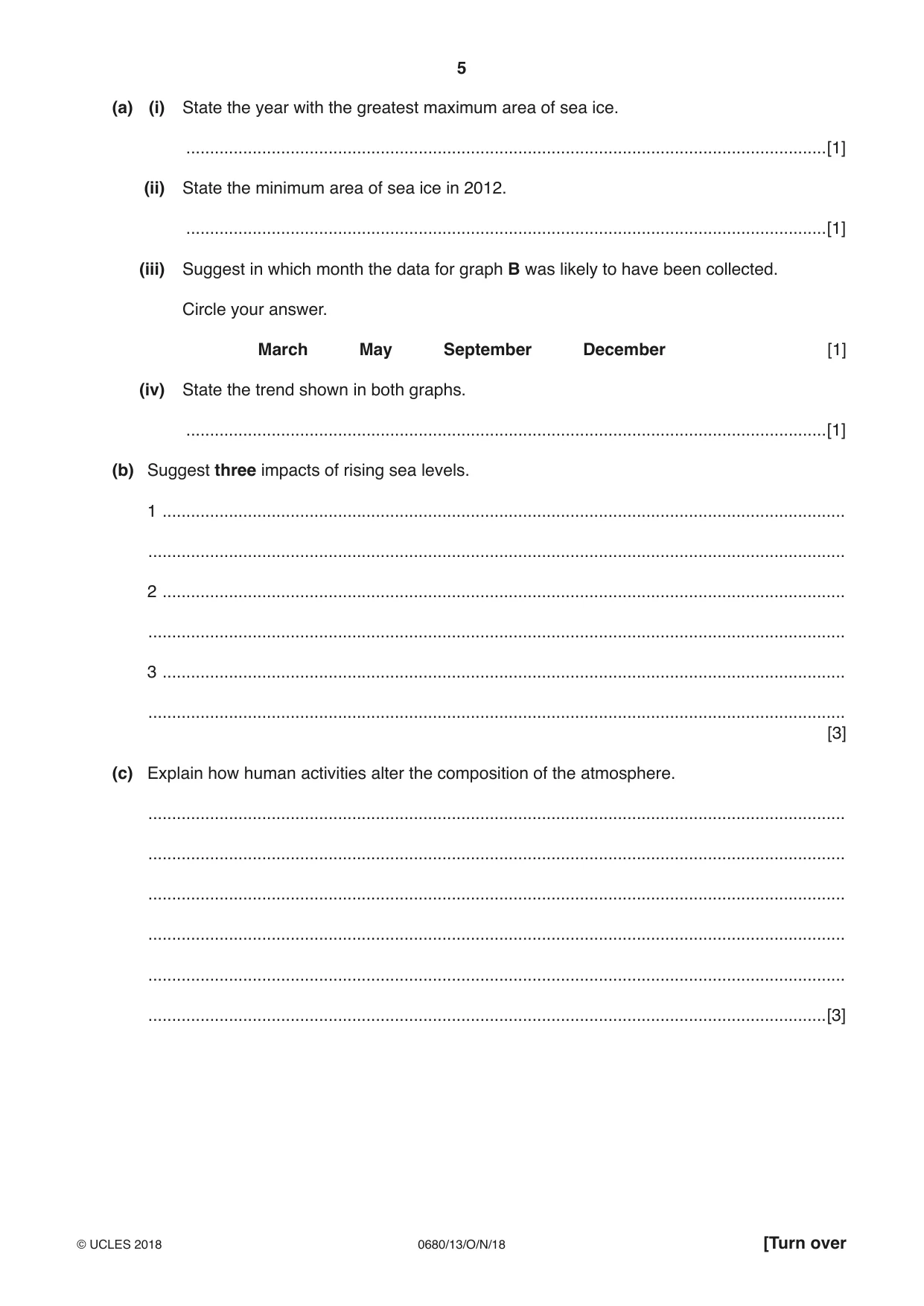
5 0680/13/O/N/18 © UCLES 2018 [Turn over (a) (i) State the year with the greatest maximum area of sea ice. …[1] (ii) State the minimum area of sea ice in 2012. …[1] (iii) Suggest in which month the data for graph B was likely to have been collected. Circle your answer. March May September December [1] (iv) State the trend shown in both graphs. …[1] (b) Suggest three impacts of rising sea levels. 1 … … 2 … … 3 … … [3] (c) Explain how human activities alter the composition of the atmosphere. … … … … … …[3]
Question paper, page 6
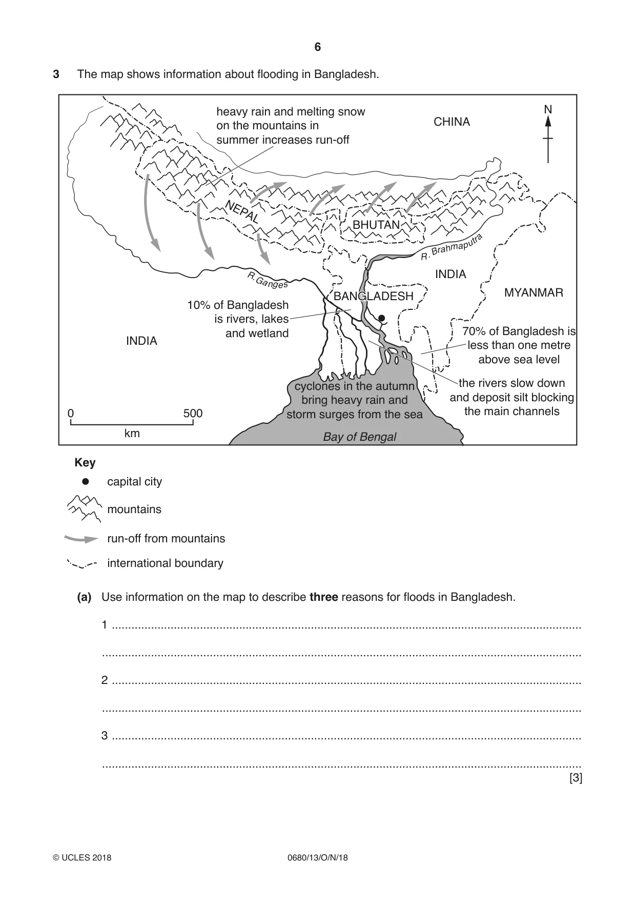
6 0680/13/O/N/18 © UCLES 2018 3 The map shows information about flooding in Bangladesh. R . B r a h m a p u t r a R . G a n g e s N Key mountains capital city INDIA CHINA MYANMAR INDIA BANGLADESH BANGLADESH BHUTAN BHUTAN NEPAL run-off from mountains international boundary 0 500 km heavy rain and melting snow on the mountains in summer increases run-off 70% of Bangladesh is less than one metre above sea level 10% of Bangladesh is rivers, lakes and wetland the rivers slow down and deposit silt blocking the main channels cyclones in the autumn bring heavy rain and storm surges from the sea Bay of Bengal (a) Use information on the map to describe three reasons for floods in Bangladesh. 1 … … 2 … … 3 … … [3]
Question paper, page 7
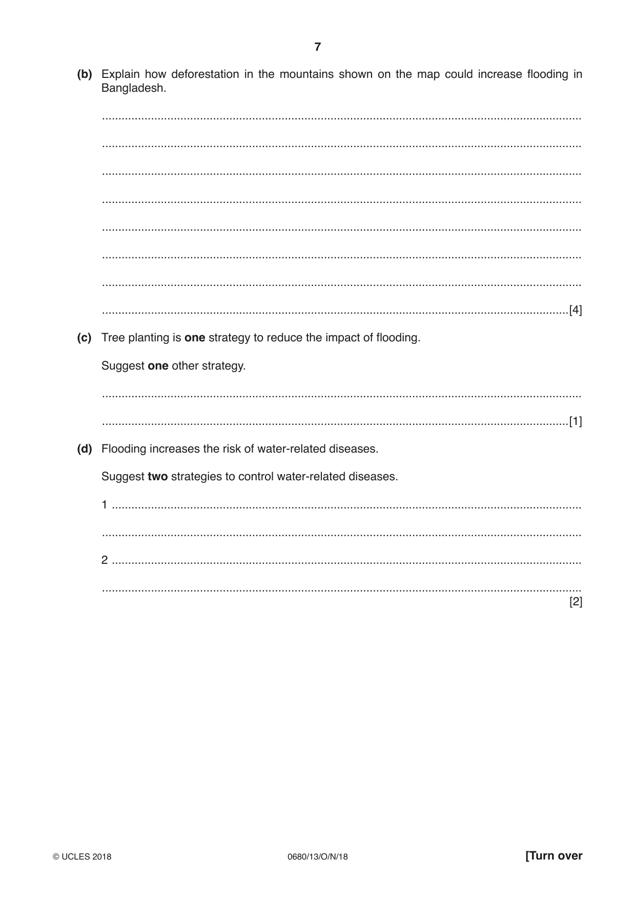
7 0680/13/O/N/18 © UCLES 2018 [Turn over (b) Explain how deforestation in the mountains shown on the map could increase flooding in Bangladesh. … … … … … … … …[4] (c) Tree planting is one strategy to reduce the impact of flooding. Suggest one other strategy. … …[1] (d) Flooding increases the risk of water-related diseases. Suggest two strategies to control water-related diseases. 1 … … 2 … … [2]
Question paper, page 8
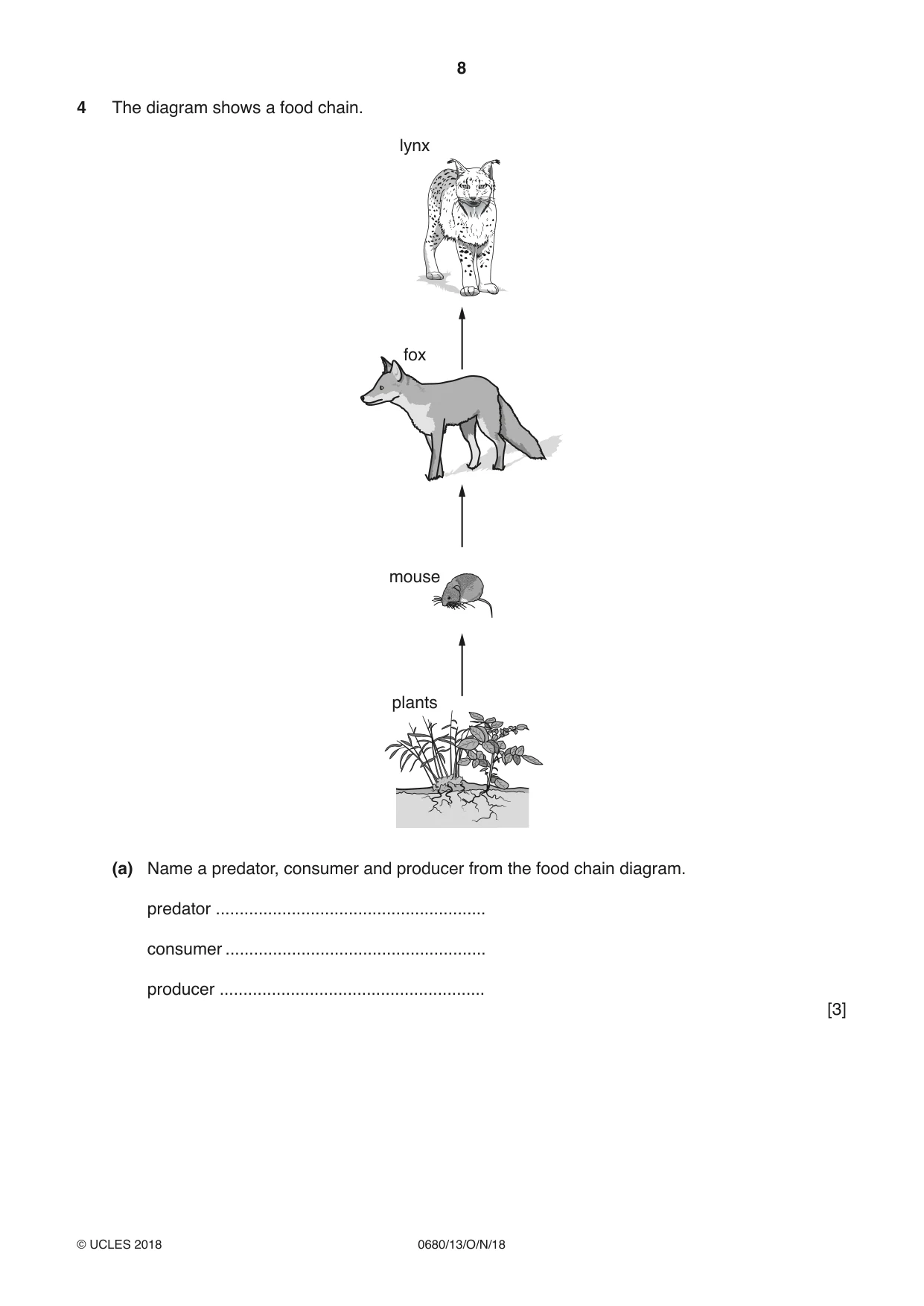
8 0680/13/O/N/18 © UCLES 2018 4 The diagram shows a food chain. fox lynx mouse plants (a) Name a predator, consumer and producer from the food chain diagram. predator … consumer … producer … [3]
Question paper, page 9
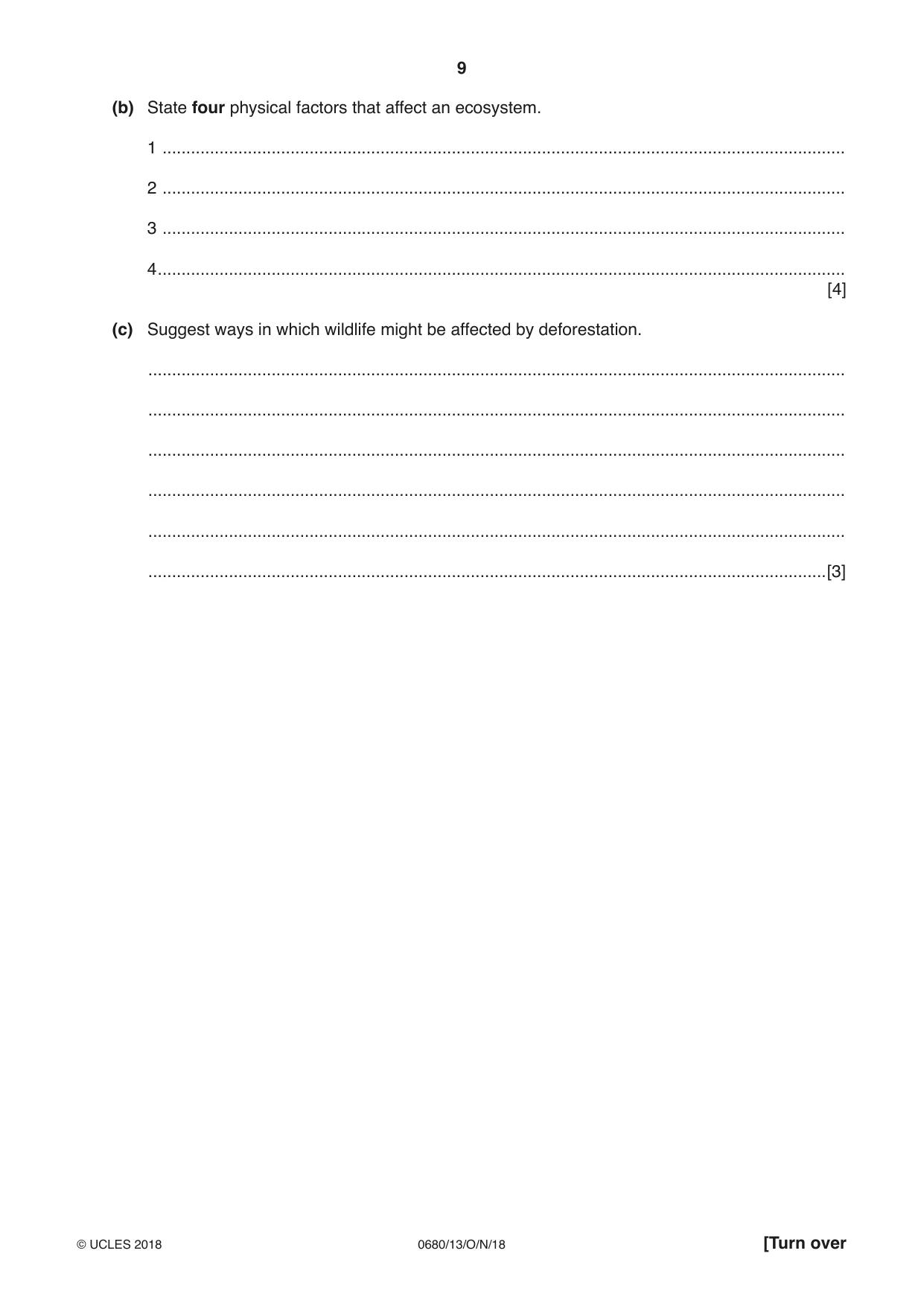
9 0680/13/O/N/18 © UCLES 2018 [Turn over (b) State four physical factors that affect an ecosystem. 1 … 2 … 3 … 4 … [4] (c) Suggest ways in which wildlife might be affected by deforestation. … … … … … …[3]
Question paper, page 10
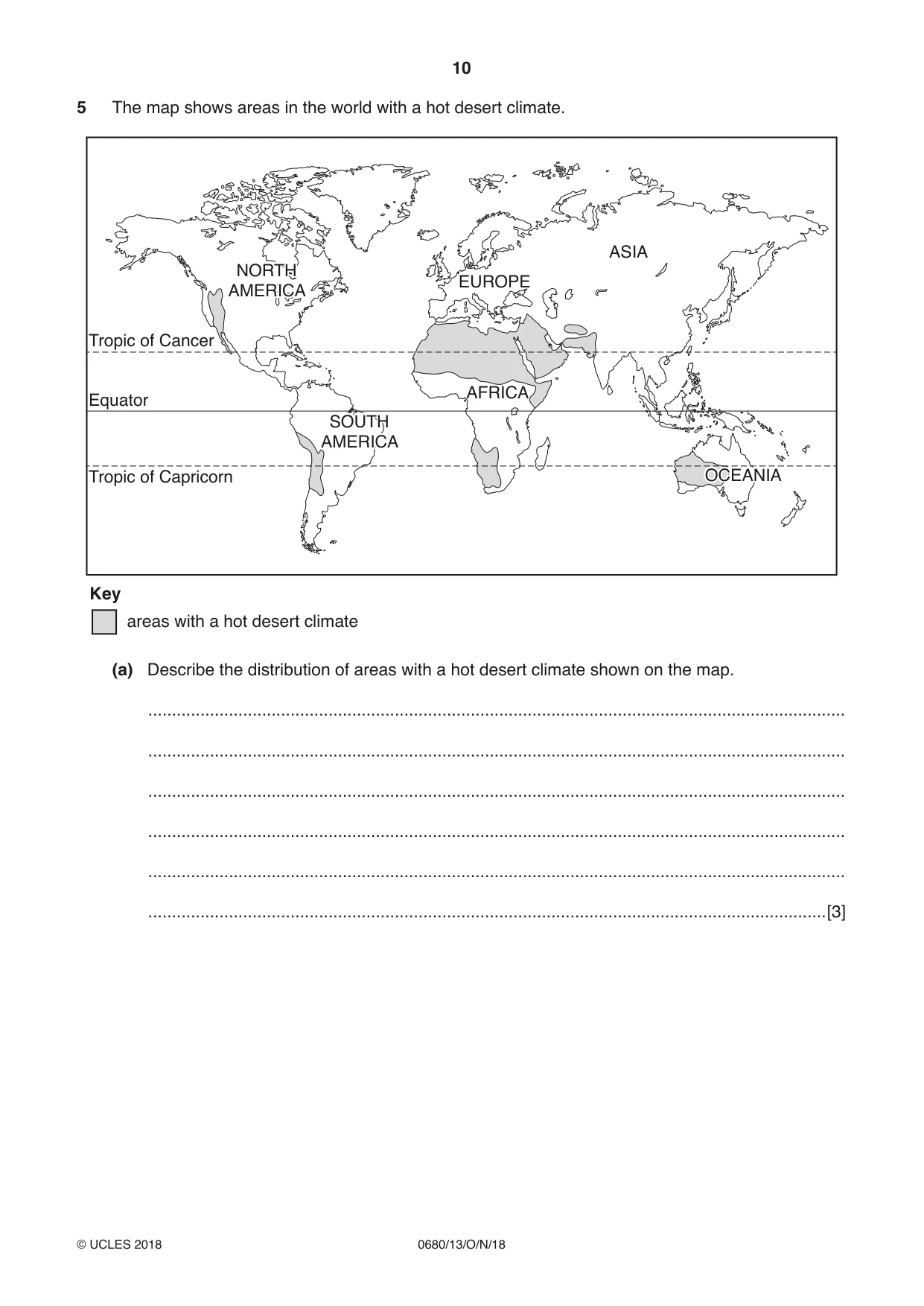
10 0680/13/O/N/18 © UCLES 2018 5 The map shows areas in the world with a hot desert climate. NORTH AMERICA NORTH AMERICA SOUTH AMERICA SOUTH AMERICA AFRICA EUROPE ASIA OCEANIA OCEANIA Tropic of Cancer Tropic of Capricorn areas with a hot desert climate Key Equator (a) Describe the distribution of areas with a hot desert climate shown on the map. … … … … … …[3]
Question paper, page 11
11 0680/13/O/N/18 © UCLES 2018 [Turn over (b) (i) Suggest why few countries in hot desert areas use desalination for fresh water supplies. … … … …[2] (ii) Suggest one environmental problem caused by desalination. … …[1] (c) Describe ways, other than by desalination, for improving the quantity of fresh water available. … … … …[2] (d) Explain why some countries have plentiful supplies of fresh water. … … … …[2]
Question paper, page 12
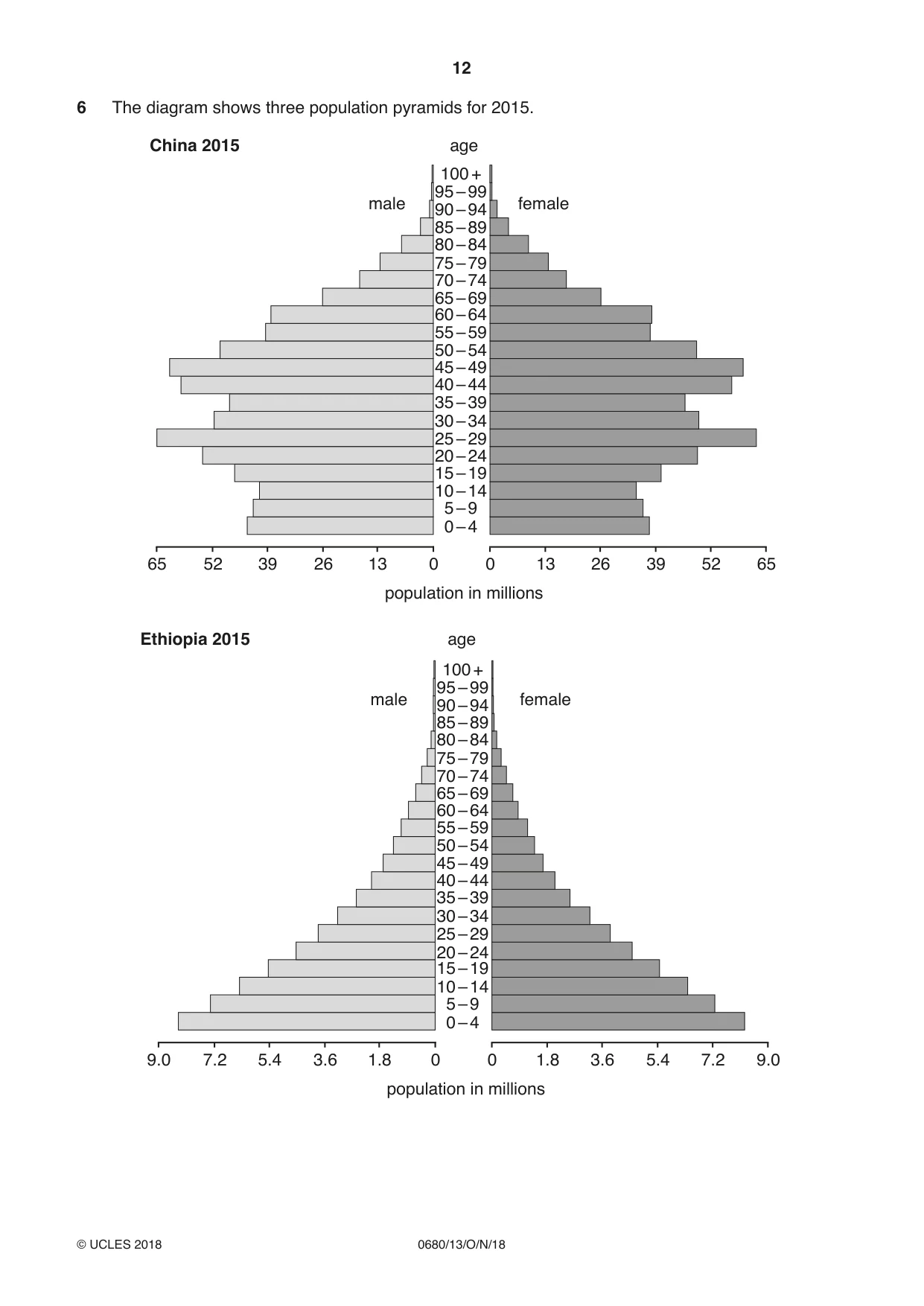
12 0680/13/O/N/18 © UCLES 2018 6 The diagram shows three population pyramids for 2015. 65 52 39 26 population in millions age China 2015 13 0 0 0 – 4 5 – 9 10 – 14 15 – 19 20 – 24 25 – 29 30 – 34 35 – 39 40 – 44 45 – 49 50 – 54 55 – 59 60 – 64 65 – 69 70 – 74 75 – 79 80 – 84 85 – 89 90 – 94 95 – 99 100 + male female 13 26 39 52 65 9.0 7.2 5.4 3.6 population in millions 1.8 0 0 0 – 4 5 – 9 10 – 14 15 – 19 20 – 24 25 – 29 30 – 34 35 – 39 40 – 44 45 – 49 50 – 54 55 – 59 60 – 64 65 – 69 70 – 74 75 – 79 80 – 84 85 – 89 90 – 94 95 – 99 100 + male female 1.8 3.6 5.4 7.2 9.0 age Ethiopia 2015
Question paper, page 13
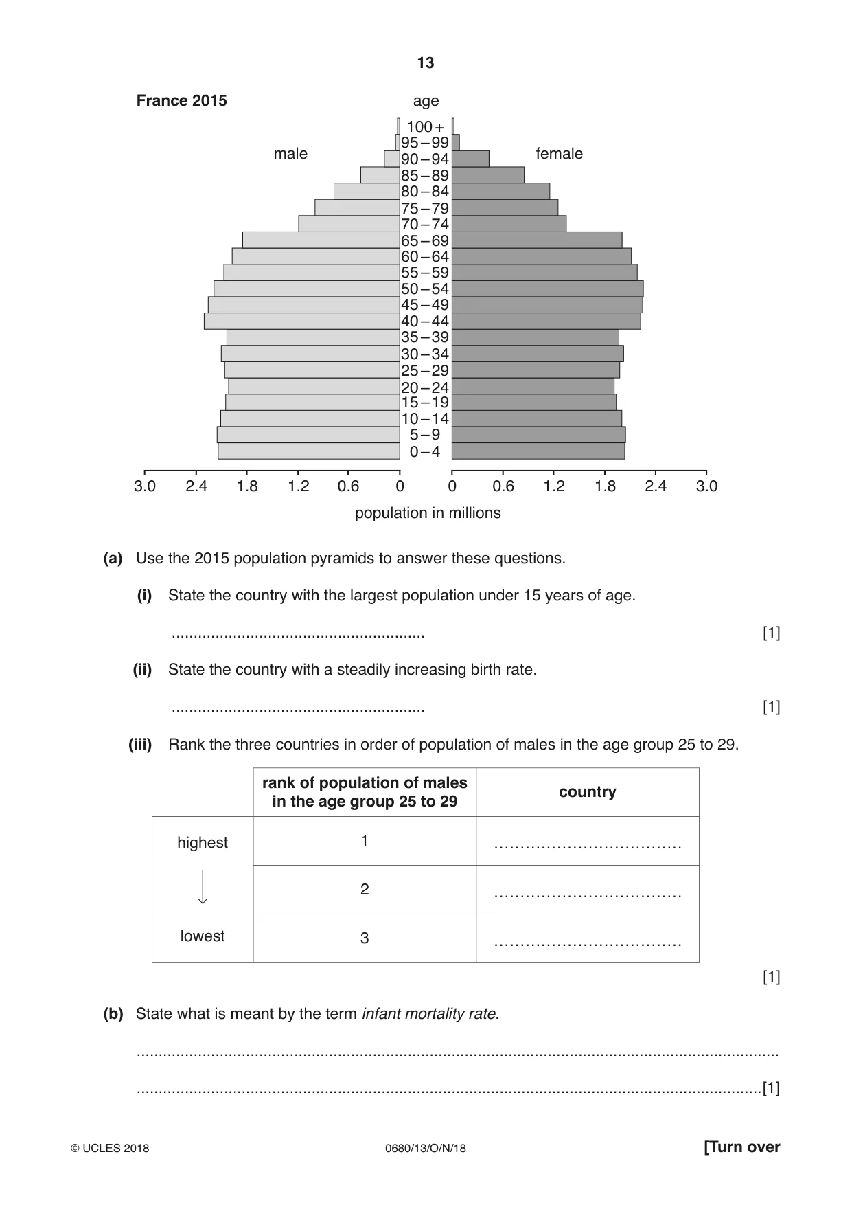
13 0680/13/O/N/18 © UCLES 2018 [Turn over 3.0 2.4 1.8 1.2 population in millions age France 2015 0.6 0 0 0 – 4 5 – 9 10 – 14 15 – 19 20 – 24 25 – 29 30 – 34 35 – 39 40 – 44 45 – 49 50 – 54 55 – 59 60 – 64 65 – 69 70 – 74 75 – 79 80 – 84 85 – 89 90 – 94 95 – 99 100 + male female 0.6 1.2 1.8 2.4 3.0 (a) Use the 2015 population pyramids to answer these questions. (i) State the country with the largest population under 15 years of age. … [1] (ii) State the country with a steadily increasing birth rate. … [1] (iii) Rank the three countries in order of population of males in the age group 25 to 29. rank of population of males in the age group 25 to 29 country highest lowest 1 ……………………………… 2 ……………………………… 3 ……………………………… [1] (b) State what is meant by the term infant mortality rate. … …[1]
Question paper, page 14
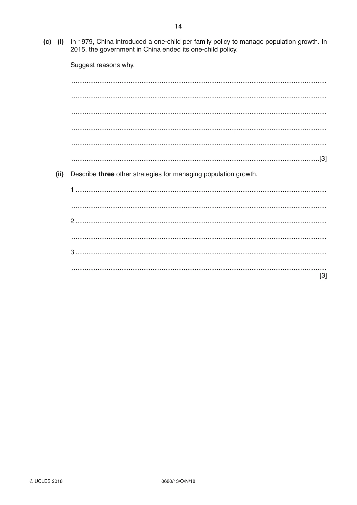
14 0680/13/O/N/18 © UCLES 2018 (c) (i) In 1979, China introduced a one-child per family policy to manage population growth. In 2015, the government in China ended its one-child policy. Suggest reasons why. … … … … … …[3] (ii) Describe three other strategies for managing population growth. 1 … … 2 … … 3 … … [3]
Question paper, page 15
15 0680/13/O/N/18 © UCLES 2018 BLANK PAGE
Question paper, page 16
16 0680/13/O/N/18 © UCLES 2018 Permission to reproduce items where third-party owned material protected by copyright is included has been sought and cleared where possible. Every reasonable effort has been made by the publisher (UCLES) to trace copyright holders, but if any items requiring clearance have unwittingly been included, the publisher will be pleased to make amends at the earliest possible opportunity. To avoid the issue of disclosure of answer-related information to candidates, all copyright acknowledgements are reproduced online in the Cambridge International Examinations Copyright Acknowledgements Booklet. This is produced for each series of examinations and is freely available to download at www.cie.org.uk after the live examination series. Cambridge International Examinations is part of the Cambridge Assessment Group. Cambridge Assessment is the brand name of University of Cambridge Local Examinations Syndicate (UCLES), which is itself a department of the University of Cambridge. BLANK PAGE
Mark scheme, page 1
This document consists of 10 printed pages. © UCLES 2018 [Turn over Cambridge Assessment International Education Cambridge International General Certificate of Secondary Education ENVIRONMENTAL MANAGEMENT 0680/13 Paper 1 October/November 2018 MARK SCHEME Maximum Mark: 60 Published This mark scheme is published as an aid to teachers and candidates, to indicate the requirements of the examination. It shows the basis on which Examiners were instructed to award marks. It does not indicate the details of the discussions that took place at an Examiners’ meeting before marking began, which would have considered the acceptability of alternative answers. Mark schemes should be read in conjunction with the question paper and the Principal Examiner Report for Teachers. Cambridge International will not enter into discussions about these mark schemes. Cambridge International is publishing the mark schemes for the October/November 2018 series for most Cambridge IGCSE™, Cambridge International A and AS Level components and some Cambridge O Level components.
Mark scheme, page 2
0680/13 Cambridge IGCSE – Mark Scheme PUBLISHED October/November 2018 © UCLES 2018 Page 2 of 10 Generic Marking Principles These general marking principles must be applied by all examiners when marking candidate answers. They should be applied alongside the specific content of the mark scheme or generic level descriptors for a question. Each question paper and mark scheme will also comply with these marking principles. GENERIC MARKING PRINCIPLE 1: Marks must be awarded in line with: • the specific content of the mark scheme or the generic level descriptors for the question • the specific skills defined in the mark scheme or in the generic level descriptors for the question • the standard of response required by a candidate as exemplified by the standardisation scripts. GENERIC MARKING PRINCIPLE 2: Marks awarded are always whole marks (not half marks, or other fractions). GENERIC MARKING PRINCIPLE 3: Marks must be awarded positively: • marks are awarded for correct/valid answers, as defined in the mark scheme. However, credit is given for valid answers which go beyond the scope of the syllabus and mark scheme, referring to your Team Leader as appropriate • marks are awarded when candidates clearly demonstrate what they know and can do • marks are not deducted for errors • marks are not deducted for omissions • answers should only be judged on the quality of spelling, punctuation and grammar when these features are specifically assessed by the question as indicated by the mark scheme. The meaning, however, should be unambiguous. GENERIC MARKING PRINCIPLE 4: Rules must be applied consistently e.g. in situations where candidates have not followed instructions or in the application of generic level descriptors.
Mark scheme, page 3
0680/13 Cambridge IGCSE – Mark Scheme PUBLISHED October/November 2018 © UCLES 2018 Page 3 of 10 GENERIC MARKING PRINCIPLE 5: Marks should be awarded using the full range of marks defined in the mark scheme for the question (however; the use of the full mark range may be limited according to the quality of the candidate responses seen). GENERIC MARKING PRINCIPLE 6: Marks awarded are based solely on the requirements as defined in the mark scheme. Marks should not be awarded with grade thresholds or grade descriptors in mind.
Mark scheme, page 4
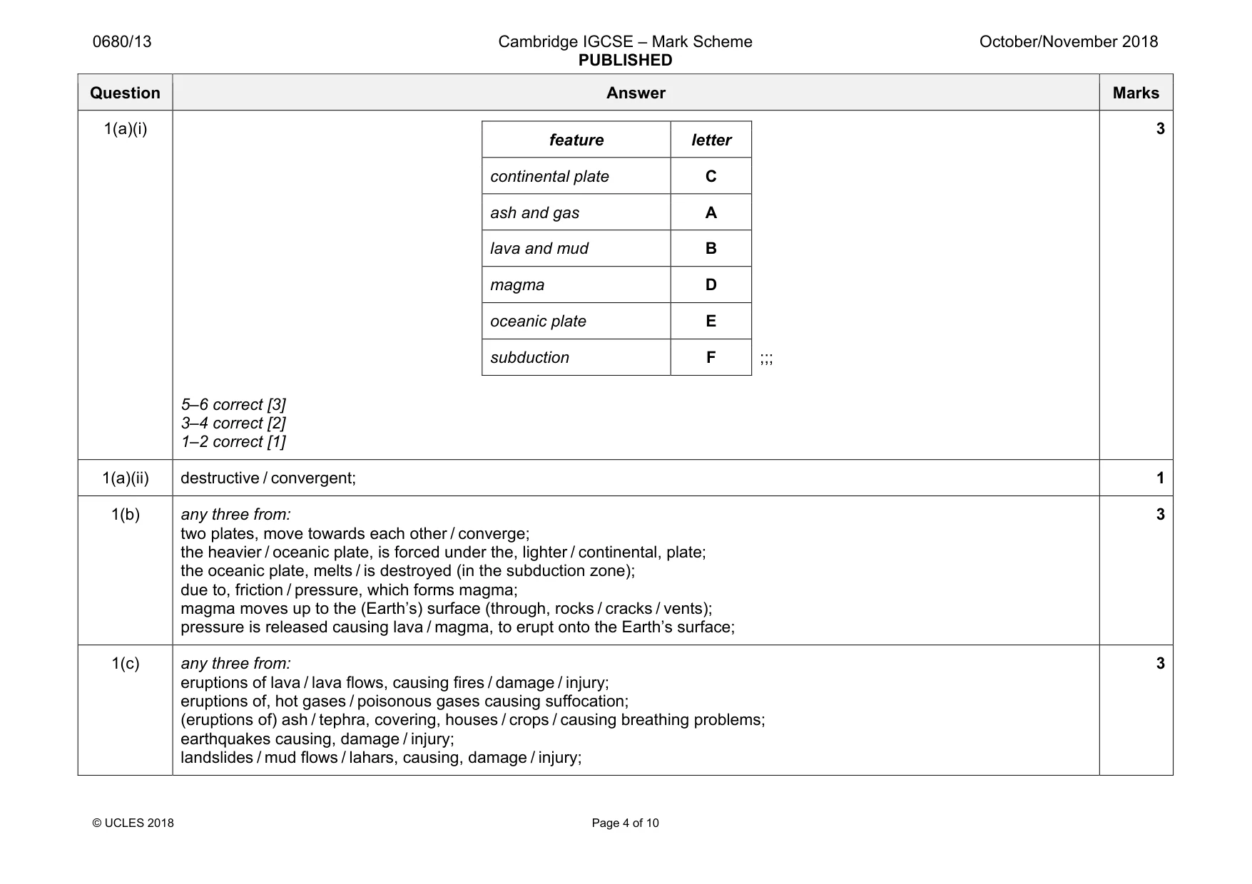
0680/13 Cambridge IGCSE – Mark Scheme PUBLISHED October/November 2018 © UCLES 2018 Page 4 of 10 Question Answer Marks 1(a)(i) feature letter continental plate C ash and gas A lava and mud B magma D oceanic plate E subduction F ;;; 5–6 correct [3] 3–4 correct [2] 1–2 correct [1] 3 1(a)(ii) destructive / convergent; 1 1(b) any three from: two plates, move towards each other / converge; the heavier / oceanic plate, is forced under the, lighter / continental, plate; the oceanic plate, melts / is destroyed (in the subduction zone); due to, friction / pressure, which forms magma; magma moves up to the (Earth’s) surface (through, rocks / cracks / vents); pressure is released causing lava / magma, to erupt onto the Earth’s surface; 3 1(c) any three from: eruptions of lava / lava flows, causing fires / damage / injury; eruptions of, hot gases / poisonous gases causing suffocation; (eruptions of) ash / tephra, covering, houses / crops / causing breathing problems; earthquakes causing, damage / injury; landslides / mud flows / lahars, causing, damage / injury; 3
Mark scheme, page 5
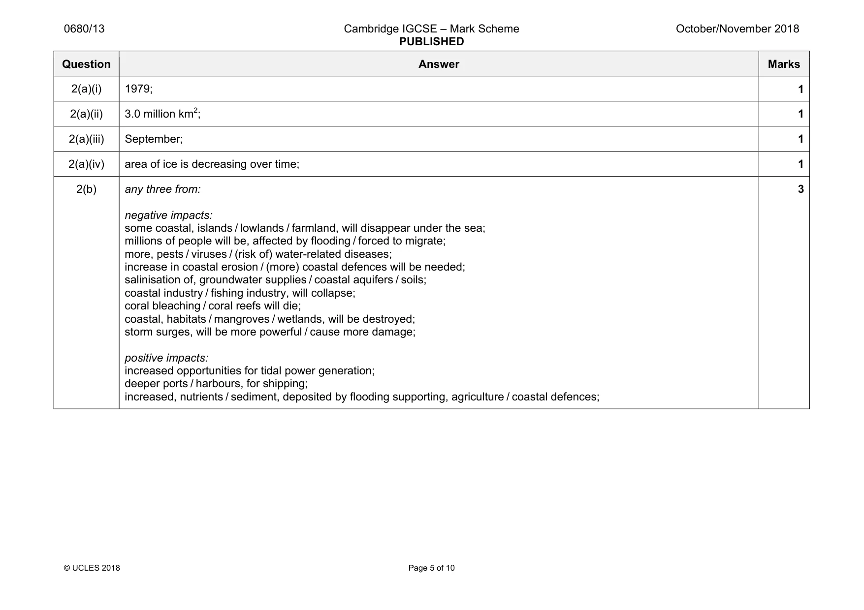
0680/13 Cambridge IGCSE – Mark Scheme PUBLISHED October/November 2018 © UCLES 2018 Page 5 of 10 Question Answer Marks 2(a)(i) 1979; 1 2(a)(ii) 3.0 million km2; 1 2(a)(iii) September; 1 2(a)(iv) area of ice is decreasing over time; 1 2(b) any three from: negative impacts: some coastal, islands / lowlands / farmland, will disappear under the sea; millions of people will be, affected by flooding / forced to migrate; more, pests / viruses / (risk of) water-related diseases; increase in coastal erosion / (more) coastal defences will be needed; salinisation of, groundwater supplies / coastal aquifers / soils; coastal industry / fishing industry, will collapse; coral bleaching / coral reefs will die; coastal, habitats / mangroves / wetlands, will be destroyed; storm surges, will be more powerful / cause more damage; positive impacts: increased opportunities for tidal power generation; deeper ports / harbours, for shipping; increased, nutrients / sediment, deposited by flooding supporting, agriculture / coastal defences; 3
Mark scheme, page 6
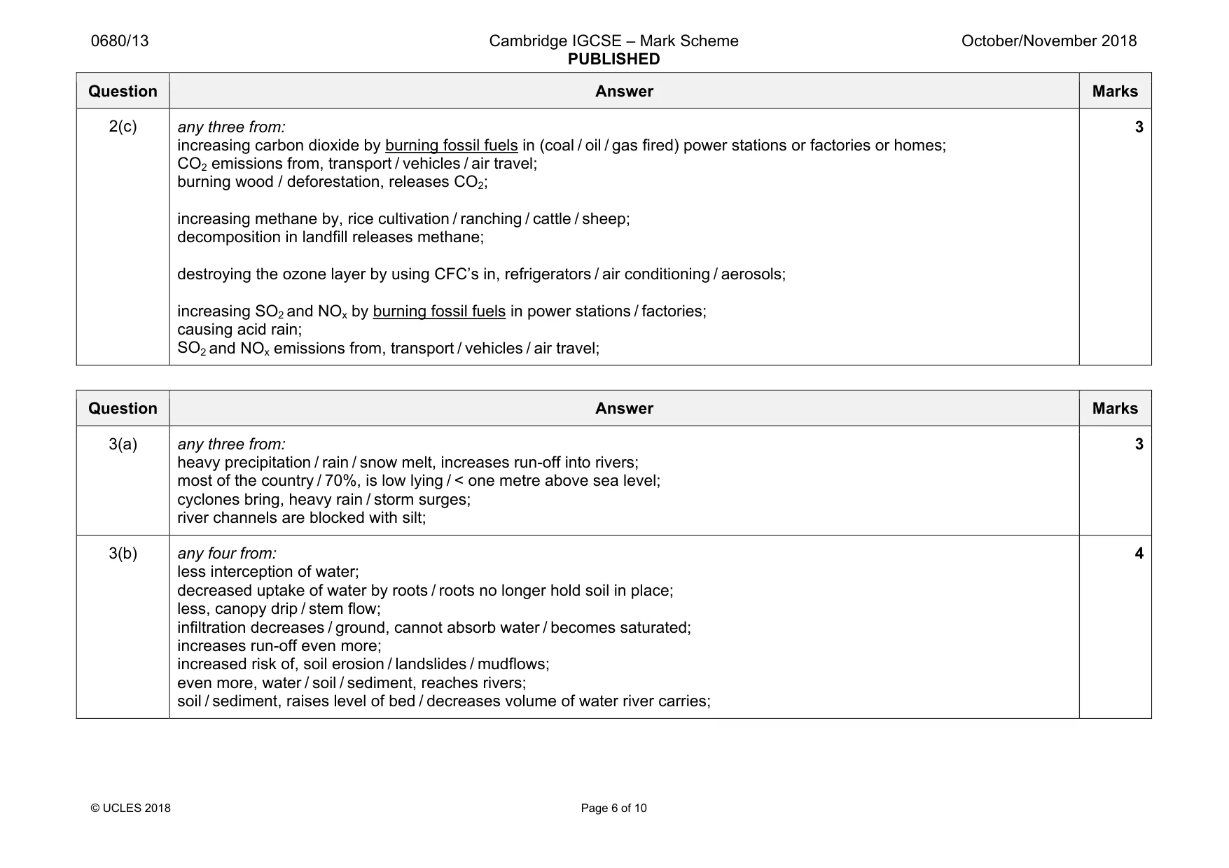
0680/13 Cambridge IGCSE – Mark Scheme PUBLISHED October/November 2018 © UCLES 2018 Page 6 of 10 Question Answer Marks 2(c) any three from: increasing carbon dioxide by burning fossil fuels in (coal / oil / gas fired) power stations or factories or homes; CO2 emissions from, transport / vehicles / air travel; burning wood / deforestation, releases CO2; increasing methane by, rice cultivation / ranching / cattle / sheep; decomposition in landfill releases methane; destroying the ozone layer by using CFC’s in, refrigerators / air conditioning / aerosols; increasing SO2 and NOx by burning fossil fuels in power stations / factories; causing acid rain; SO2 and NOx emissions from, transport / vehicles / air travel; 3 Question Answer Marks 3(a) any three from: heavy precipitation / rain / snow melt, increases run-off into rivers; most of the country / 70%, is low lying / < one metre above sea level; cyclones bring, heavy rain / storm surges; river channels are blocked with silt; 3 3(b) any four from: less interception of water; decreased uptake of water by roots / roots no longer hold soil in place; less, canopy drip / stem flow; infiltration decreases / ground, cannot absorb water / becomes saturated; increases run-off even more; increased risk of, soil erosion / landslides / mudflows; even more, water / soil / sediment, reaches rivers; soil / sediment, raises level of bed / decreases volume of water river carries; 4
Mark scheme, page 7
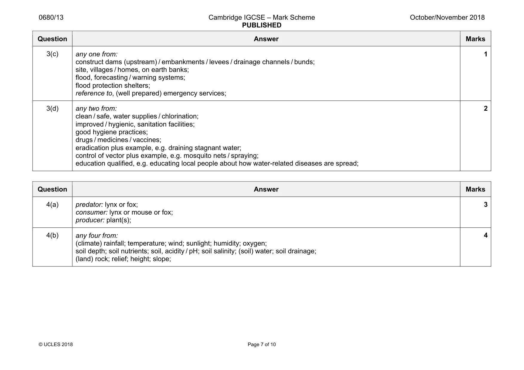
0680/13 Cambridge IGCSE – Mark Scheme PUBLISHED October/November 2018 © UCLES 2018 Page 7 of 10 Question Answer Marks 3(c) any one from: construct dams (upstream) / embankments / levees / drainage channels / bunds; site, villages / homes, on earth banks; flood, forecasting / warning systems; flood protection shelters; reference to, (well prepared) emergency services; 1 3(d) any two from: clean / safe, water supplies / chlorination; improved / hygienic, sanitation facilities; good hygiene practices; drugs / medicines / vaccines; eradication plus example, e.g. draining stagnant water; control of vector plus example, e.g. mosquito nets / spraying; education qualified, e.g. educating local people about how water-related diseases are spread; 2 Question Answer Marks 4(a) predator: lynx or fox; consumer: lynx or mouse or fox; producer: plant(s); 3 4(b) any four from: (climate) rainfall; temperature; wind; sunlight; humidity; oxygen; soil depth; soil nutrients; soil, acidity / pH; soil salinity; (soil) water; soil drainage; (land) rock; relief; height; slope; 4
Mark scheme, page 8
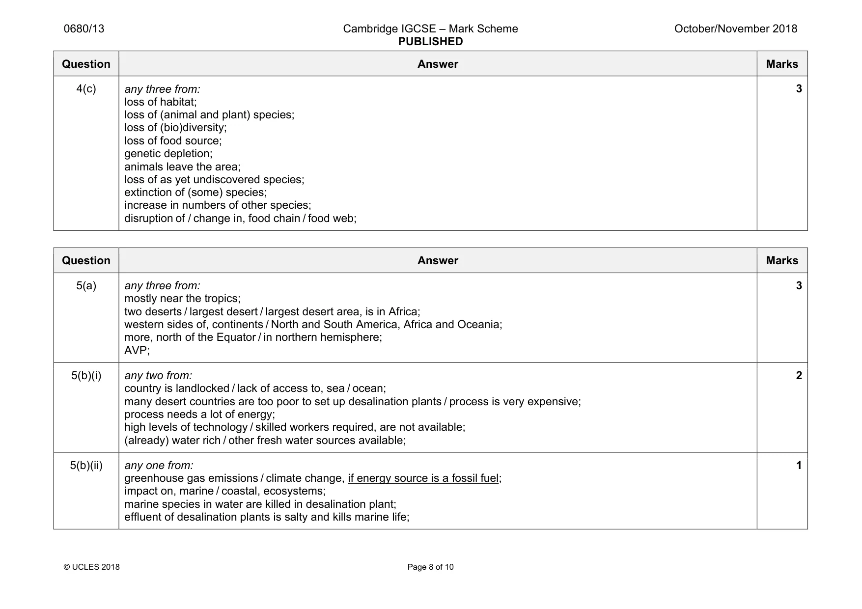
0680/13 Cambridge IGCSE – Mark Scheme PUBLISHED October/November 2018 © UCLES 2018 Page 8 of 10 Question Answer Marks 4(c) any three from: loss of habitat; loss of (animal and plant) species; loss of (bio)diversity; loss of food source; genetic depletion; animals leave the area; loss of as yet undiscovered species; extinction of (some) species; increase in numbers of other species; disruption of / change in, food chain / food web; 3 Question Answer Marks 5(a) any three from: mostly near the tropics; two deserts / largest desert / largest desert area, is in Africa; western sides of, continents / North and South America, Africa and Oceania; more, north of the Equator / in northern hemisphere; AVP; 3 5(b)(i) any two from: country is landlocked / lack of access to, sea / ocean; many desert countries are too poor to set up desalination plants / process is very expensive; process needs a lot of energy; high levels of technology / skilled workers required, are not available; (already) water rich / other fresh water sources available; 2 5(b)(ii) any one from: greenhouse gas emissions / climate change, if energy source is a fossil fuel; impact on, marine / coastal, ecosystems; marine species in water are killed in desalination plant; effluent of desalination plants is salty and kills marine life; 1
Mark scheme, page 9
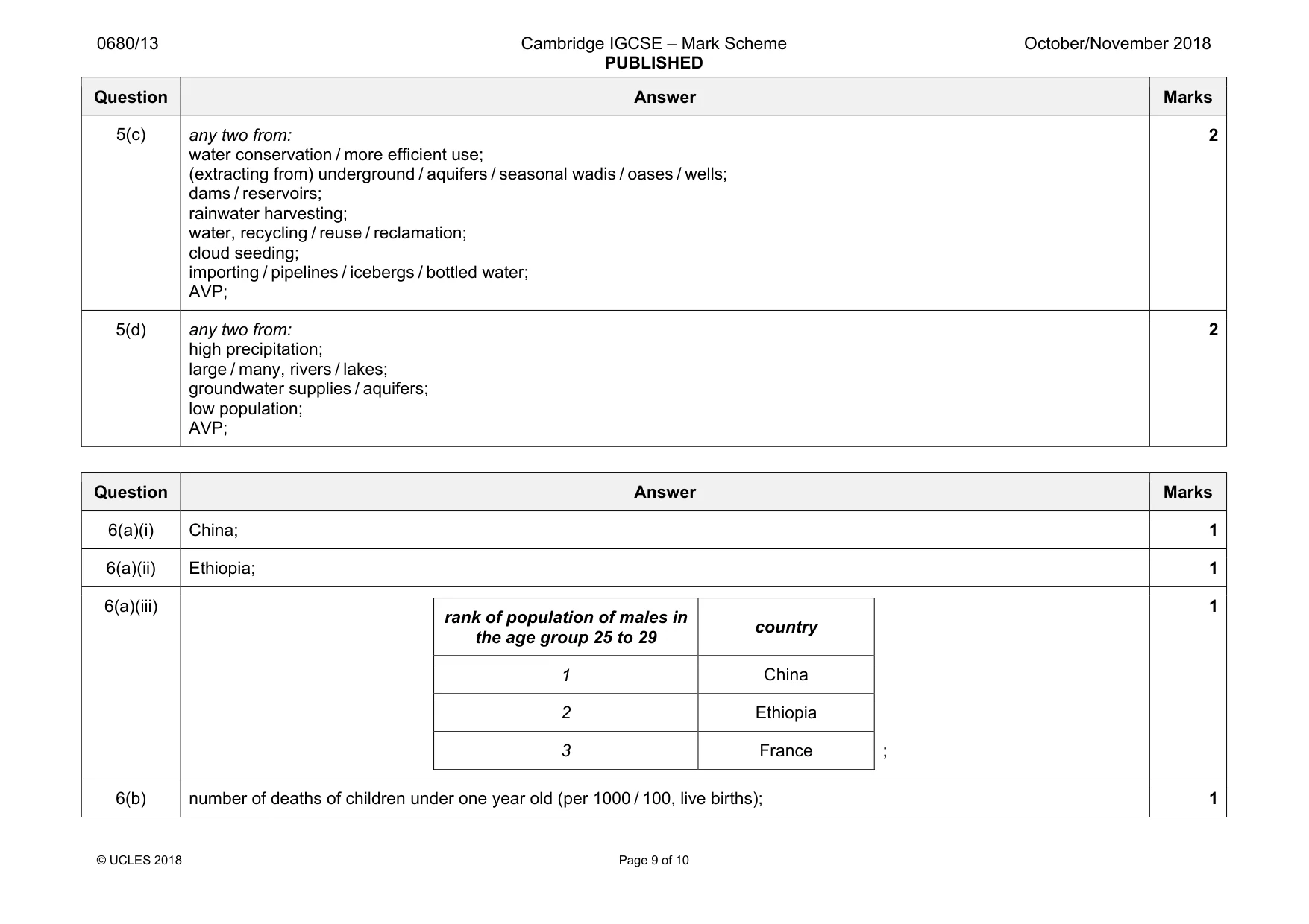
0680/13 Cambridge IGCSE – Mark Scheme PUBLISHED October/November 2018 © UCLES 2018 Page 9 of 10 Question Answer Marks 5(c) any two from: water conservation / more efficient use; (extracting from) underground / aquifers / seasonal wadis / oases / wells; dams / reservoirs; rainwater harvesting; water, recycling / reuse / reclamation; cloud seeding; importing / pipelines / icebergs / bottled water; AVP; 2 5(d) any two from: high precipitation; large / many, rivers / lakes; groundwater supplies / aquifers; low population; AVP; 2 Question Answer Marks 6(a)(i) China; 1 6(a)(ii) Ethiopia; 1 6(a)(iii) rank of population of males in the age group 25 to 29 country 1 China 2 Ethiopia 3 France ; 1 6(b) number of deaths of children under one year old (per 1000 / 100, live births); 1
Mark scheme, page 10
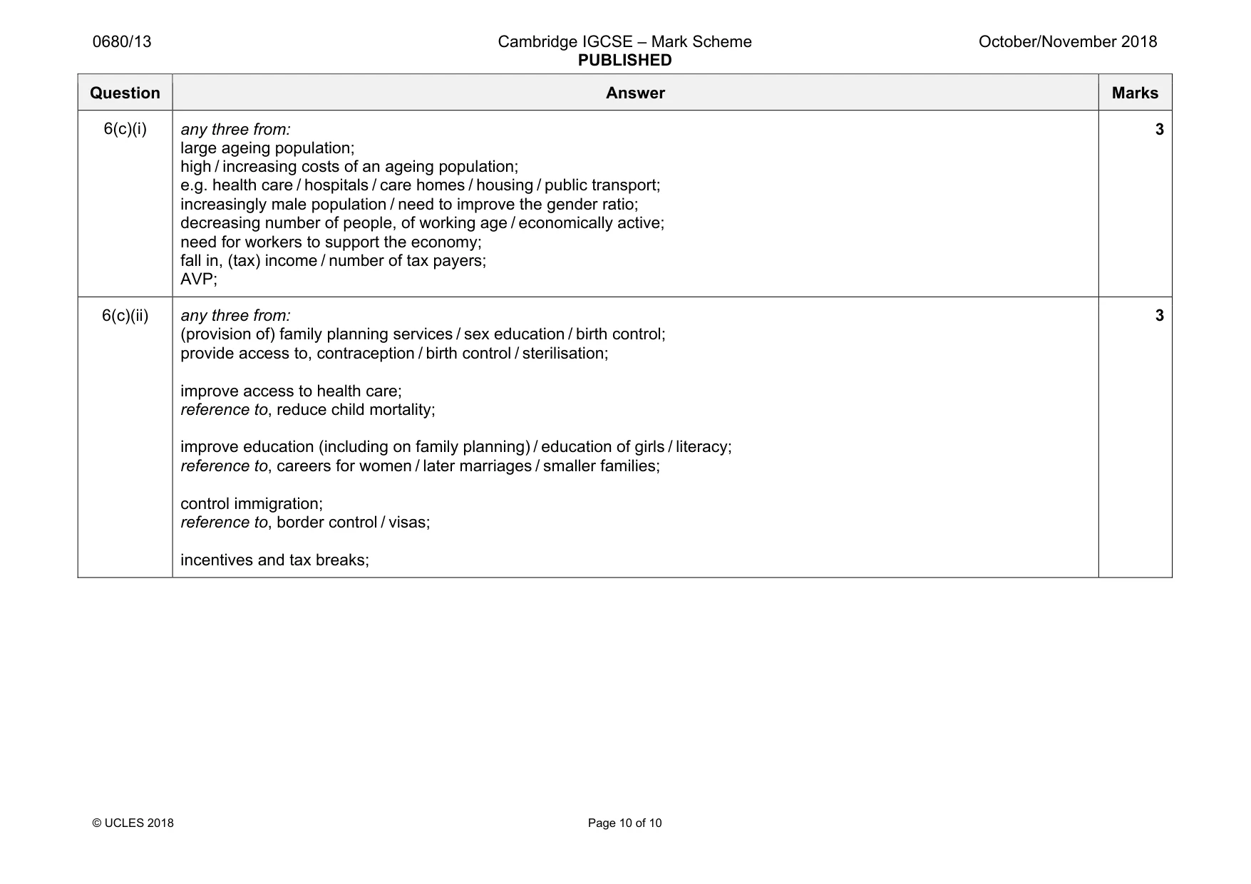
0680/13 Cambridge IGCSE – Mark Scheme PUBLISHED October/November 2018 © UCLES 2018 Page 10 of 10 Question Answer Marks 6(c)(i) any three from: large ageing population; high / increasing costs of an ageing population; e.g. health care / hospitals / care homes / housing / public transport; increasingly male population / need to improve the gender ratio; decreasing number of people, of working age / economically active; need for workers to support the economy; fall in, (tax) income / number of tax payers; AVP; 3 6(c)(ii) any three from: (provision of) family planning services / sex education / birth control; provide access to, contraception / birth control / sterilisation; improve access to health care; reference to, reduce child mortality; improve education (including on family planning) / education of girls / literacy; reference to, careers for women / later marriages / smaller families; control immigration; reference to, border control / visas; incentives and tax breaks; 3
What you needed in this session
Cambridge’s own grade thresholds for 2018 Oct/Nov, Paper 1 · Variant 3. A higher threshold means an easier paper — the bar moves with how the cohort did.